The enhanced capabilities of the Suomi NPP satellite's day-night band are really becoming clear, as was seen this week when Tropical Storm Flossie was heading toward Hawaii. On Monday, July 29th, the lack of organization of the system made it difficult to understand the storm’s central circulation. Infrared data, though able to provide cloud imagery during the night, is best at measuring cloud-top properties. Flossie, however, had a lower-level circulation that was evident in visible imagery earlier in the day. At nighttime that information was lost using traditional satellite technology, such as GOES West. The day-night-band on Suomi NPP provides visible-like information during nighttime hours when only moonlight is available. When Suomi NPP passed over the storm around 1:00am (local), the day-night band imagery allowed forecasters to identify a center of circulation that was more north than previously estimated. Two passes from Suomi NPP (at 11 and 12z, respectively) are shown here. The spiral of the lower level clouds and center of circulation can be seen northwest of Hawaii, whereas the more detailed and higher cloud top areas are due east of the Big Island. Also visible are the nighttime lights of Honolulu on Oahu, along with other cities throughout the island chain.  Credit NASA/NOAA  An unlabeled version may be downloaded here: <a href="http://1.usa.gov/1bOjhN6" rel="nofollow">1.usa.gov/1bOjhN6</a>  <b><a href="http://www.nasa.gov/audience/formedia/features/MP_Photo_Guidelines.html" rel="nofollow">NASA image use policy.</a></b>  <b><a href="http://www.nasa.gov/centers/goddard/home/index.html" rel="nofollow">NASA Goddard Space Flight Center</a></b> enables NASA’s mission through four scientific endeavors: Earth Science, Heliophysics, Solar System Exploration, and Astrophysics. Goddard plays a leading role in NASA’s accomplishments by contributing compelling scientific knowledge to advance the Agency’s mission.  <b>Follow us on <a href="http://twitter.com/NASA_GoddardPix" rel="nofollow">Twitter</a></b>  <b>Like us on <a href="http://www.facebook.com/pages/Greenbelt-MD/NASA-Goddard/395013845897?ref=tsd" rel="nofollow">Facebook</a></b>  <b>Find us on <a href="http://instagram.com/nasagoddard?vm=grid" rel="nofollow">Instagram</a></b>
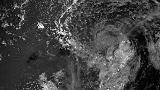
Satellite Nighttime Imagery Assists in Flossie Track
jsc2021e052205 (8/26/2020) --- A preflight imagery of personnel posing with the CUAVA-1 flight module prior to thermal vacuum testing at the Australian Research Council Industrial Transformation Training Centre (AITC). Image Credit: CUAVA.
CUAVA-1 CubeSat Preflight Imagery
Coverage of the imagery and views received from the Orion spacecraft on Nov. 16 following liftoff of Orion atop the Space Launch System from the Kennedy Space Center in Florida just hours before. Orion is completing a 25-day test flight of all key systems as part of Artemis I mission.
Orion_Spacecraft_Earth_Views_20221116
jsc2021e063274 (3/17/2021) --- Preflight imagery for the Characterizing Antibiotic Resistance in Microgravity Environments (CARMEn) experiment, part of Nanoracks Module-96. CARMEn observes how spaceflight affects the growth of a culture of two species of bacteria. The Mechanical Engineering team is pictured in the Mechanical Engineering Shop with connector piece. From left to right: Deanna Duqmaq, Alfonso Ussia, Gaurav Kulkarni, Kalpana Ganeshan.
Preflight Imagery for the CARMEn Investigation
jsc2021e063278 (12/10/2021) --- Preflight imagery for the Characterizing Antibiotic Resistance in Microgravity Environments (CARMEn) experiment, part of Nanoracks Module-96. CARMEn observes how spaceflight affects the growth of a culture of two species of bacteria. SPOCS Project Co-Lead Swati Ravi is pictured in the Columbia University Dietrich Biological Shape and Pattern Formation Lab with prepared diluted bacterial colonies of P. aeruginosa and S. aureus.
Preflight Imagery for the CARMEn Investigation
jsc2021e063280 (12/10/2021) --- Preflight imagery for the Characterizing Antibiotic Resistance in Microgravity Environments (CARMEn) experiment, part of Nanoracks Module-96. CARMEn observes how spaceflight affects the growth of a culture of two species of bacteria. SPOCS Project Co-Lead Swati Ravi is pictured operating an imaging microscope to observe P. aeruginosa and S. aureus bacterial biofilms in the Columbia University Dietrich Biological Shape and Pattern Formation Laboratory.
Preflight Imagery for the CARMEn Investigation
jsc2021e063277 (12/10/2021) --- Preflight imagery for the Characterizing Antibiotic Resistance in Microgravity Environments (CARMEn) experiment, part of Nanoracks Module-96. CARMEn observes how spaceflight affects the growth of a culture of two species of bacteria. Team members are pictured alongside the payload at Carleton Laboratory, where the payload’s structural integrity is tested. From left to right: Kalpana Ganeshan, Swati Ravi, Juan Zuniga, Gaurav Kulkarni, Alfonso Ussia.
Preflight Imagery for the CARMEn Investigation
NASA Terra spacecraft captured this imagery and data over Hurricane Sandy as the storm approached the U.S. east coast on Oct. 28, 2012. The image at left covers an area 250 miles 400 kilometers wide and extends from Massachusetts to Florida.
NASA Spacecraft Imagery Shows Hurricane Sandy Wind Flow
This imagery is being released in association with NASA Mars Science Laboratory mission. This is a temporary caption to be replaced as soon as more information is available.
Rover Takes Its First Steps
This imagery is being released in association with NASA Mars Science Laboratory mission. This is a temporary caption to be replaced as soon as more information is available.
Nailing Down Curiosity Landing Site
In addition to an elevation model of most of Earth landmass, NASA Shuttle Radar Topography Mission will produce C-band radar imagery of the same area.
SRTM Radar - Landsat Image Comparison, Patagonia, Argentina
The objective of NASA Shuttle Imaging Radar A SIR-A was to observe the Earth by use of radar imagery, acquire and transmit data of different geologic regions. This is a view of China in 2000.
Radar view of China
Measuring in at 10,159 miles (16,350 kilometers) in width (as of April 3, 2017) Jupiter's Great Red Spot is 1.3 times as wide as Earth. This composite image was generated by combining NASA imagery of Earth with an image of Jupiter taken by astronomer Christopher Go.  This composite image was generated by combining NASA imagery of Earth with an image of Jupiter taken by astronomer Christopher Go.  https://photojournal.jpl.nasa.gov/catalog/PIA21774
PIA21774
iss063e113776 (10/20/2020) --- A view of the CubeLab Microscope Imagery Tech Demo aboard the International Space Station (ISS). The CubeLab Microscope Imagery Technology Demonstration (CubeLab Microscope Imagery Tech Demo) tests enhanced microscope imagery capabilities for experiments aboard the space station. Images provide a primary way to document and analyze many microgravity investigations, and better quality images could lead to better results.
iss063e113776
To present the best information in a single view of Jupiter moon Ganymede, a global image mosaic was assembled, incorporating the best available imagery from NASA Voyager 1 and 2 spacecraft and NASA Galileo spacecraft.
Ganymede Global Geologic Map and Global Image Mosaic
In August 2001, NASA Galileo spacecraft has returned imagery of a hot spot on Jupiter moon Io that was the source of a towering plume indicating a sulfur-dioxide concentration that may have been fallout from the plume.
A New Hot Spot on Northern Io
This animation shows a mosaic of imagery from Cassini radar instrument obtained during three flybys of Titan north pole: T16 July 22, 2006, T18 Sept. 23, 2006 and T19 Oct. 9, 2006
Titan Lakes Movie
Data from a portion of the imagery acquired by NASA Terra spacecraft during 2000-2002 were combined to create this cloud-free natural-color mosaic of southwestern Europe and northwestern Morocco and Algeria.
Where Europe meets Africa
This is a frame from an animation of a rotating globe of Jupiter moon Ganymede, with a geologic map superimposed over a global color mosaic, incorporating the best available imagery from NASA Voyager 1 and 2 spacecraft, and Galileo spacecraft.
Rotating Globe of Ganymede Geology
This radar imagery of asteroid 1998 QE2 and its moon was generated from data collected by NASA 230-foot-wide 70-meter Deep Space Network antenna at Goldstone, Calif., on June 1, 2013.
Radar Movies Highlight Asteroid 1998 QE2 and Its Moon
This illustration depicts a concept for the possible extent of an ancient lake inside Gale Crater. The base map combines image data from the Context Camera on NASA Mars Reconnaissance Orbiter and color information from Viking Orbiter imagery.
Possible Extent of Ancient Lake in Gale Crater, Mars
The objective of NASA Shuttle Imaging Radar A SIR-A was to observe the Earth by use of radar imagery, acquire and transmit data of different geologic regions. This is a view of New Guinea in 2000.
Radar view of New Guinea
Ash from Iceland Eyjafjallajökull volcano, viewed here in imagery from NASA Terra spacecraft on May 16, 2010, once again disrupted air traffic over Europe with the closure of major airports in the United Kingdom and the Netherlands.
Eyjafjallajökull Ash Continues to Disrupt Air Traffic
Digital elevation models DEMs, such as those produced by NASA Shuttle Radar Topography Mission SRTM, allow user-controlled visualization of the Earth landforms that is not possible using satellite imagery alone.
Landsat - SRTM Shaded Relief Comparison, Los Angeles and Vicinity
Tupan Caldera, a volcanic crater on Jupiter moon Io, has a relatively cool area, possibly an island, in its center, as indicated by infrared imagery from NASA Galileo spacecraft during an Oct. 16, 2001 flyby.
Io Tupan Caldera in Infrared
NASA JSC Electronic Imagery
MS Usachev with camera on middeck
STS126 launch imagery
STS-126 launch
STS126 launch imagery
STS-126 launch
STS126 launch imagery
STS-126 launch
STS126 launch imagery
STS-126 launch
STS126 launch imagery
STS-126 launch preparations
STS126 launch imagery
STS-126 launch
STS126 launch imagery
STS-126 launch
STS126 launch imagery
STS-126 launch
STS126 launch imagery
STS-126 launch
STS126 launch imagery
STS-126 launch
STS126 launch imagery
STS-126 launch
STS126 launch imagery
STS-126 launch
STS126 launch imagery
STS-126 launch preparations
STS126 launch imagery
STS-126 launch
NASA JSC Electronic Imagery
MS Helms with stowage items on the middeck
Russian 24S Returned Imagery Part 208
Kondratyev during EVA
Russian 24S Returned Imagery Part 208
ESA Johannes Kepler ATV-2 during approach
Russian 24S Returned Imagery Part 208
Skripochka and Kondratyev during EVA
Russian 24S Returned Imagery Part 208
ESA Johannes Kepler ATV-2 during approach
Russian 24S Returned Imagery Part 208
Kondratyev during EVA
Russian 24S Returned Imagery Part 208
Kondratyev during EVA
Russian 24S Returned Imagery Part 208
Skripochka during EVA
Russian 24S Returned Imagery Part 208
Skripochka during EVA
Russian 24S Returned Imagery Part 208
Skripochka during EVA
Russian 24S Returned Imagery Part 208
Skripochka and Kondratyev during EVA
Russian 24S Returned Imagery Part 208
Kondratyev during EVA
Russian 24S Returned Imagery Part 208
Skripochka during EVA
Russian 24S Returned Imagery Part 208
Kondratyev during EVA
Russian 24S Returned Imagery Part 208
Skripochka during EVA
Russian 24S Returned Imagery Part 208
Skripochka and Kondratyev during EVA
Russian 24S Returned Imagery Part 208
STS-133 Space Shuttle Discovery
Russian 24S Returned Imagery Part 208
ESA Johannes Kepler ATV-2 during approach
Russian 24S Returned Imagery Part 208
Skripochka during EVA
Russian 24S Returned Imagery Part 208
Progress M-08M Spacecraft during departure
Russian 24S Returned Imagery Part 208
Skripochka and Kondratyev during EVA
Russian 24S Returned Imagery Part 208
Kondratyev during EVA
Russian 24S Returned Imagery Part 208
Skripochka during EVA
Russian 24S Returned Imagery Part 208
Skripochka during EVA
Russian 24S Returned Imagery Part 208
Skripochka during EVA
Russian 24S Returned Imagery Part 208
Skripochka and Kondratyev during EVA
Russian 24S Returned Imagery Part 208
Kondratyev during EVA
Russian 24S Returned Imagery Part 208
Kondratyev during EVA
STS-53 Discovery, Orbiter Vehicle (OV) 103, Department of Defense (DOD) mission Hand-held Earth-oriented Real-time Cooperative, User-friendly, Location, targeting, and Environmental System (Hercules) spaceborne experiment equipment is documented in this table top view. HERCULES is a joint NAVY-NASA-ARMY payload designed to provide real-time high resolution digital electronic imagery and geolocation (latitude and longitude determination) of earth surface targets of interest. HERCULES system consists of (from left to right): a specially modified GRID Systems portable computer mounted atop NASA developed Playback-Downlink Unit (PDU) and the Naval Research Laboratory (NRL) developed HERCULES Attitude Processor (HAP); the NASA-developed Electronic Still Camera (ESC) Electronics Box (ESCEB) including removable imagery data storage disks and various connecting cables; the ESC (a NASA modified Nikon F-4 camera) mounted atop the NRL HERCULES Inertial Measurement Unit (HIMU) containing the three-axis ring-laser gyro.
STS-53 Discovery, OV-103, DOD Hercules digital electronic imagery equipment
SpaceX USCV-7 (Crew 7) Imagery provided by SpaceX
jsc2023e037656
C-130 aircraft Shoreline Amphitheater: Thermal IR Imagery
ARC-1969-AC87-0060-2
SpaceX USCV-7 (Crew 7) Imagery provided by SpaceX
jsc2023e037688
C-130 aircraft Shoreline Amphitheater: Thermal IR Imagery
ARC-1969-AC87-0060-1
SpaceX USCV-7 (Crew 7) Imagery provided by SpaceX
jsc2023e037662
SpaceX USCV-7 (Crew 7) Imagery provided by SpaceX
jsc2023e037661
SpaceX USCV-7 (Crew 7) Imagery provided by SpaceX
jsc2023e037714
C-130 aircraft Shoreline Amphitheater: Thermal IR Imagery
ARC-1969-AC87-0060-3
SpaceX USCV-7 (Crew 7) Imagery provided by SpaceX
jsc2023e037708
SpaceX USCV-7 (Crew 7) Imagery provided by SpaceX
jsc2023e037697
SpaceX USCV-7 (Crew 7) Imagery provided by SpaceX
jsc2023e037676
SpaceX USCV-7 (Crew 7) Imagery provided by SpaceX
jsc2023e037664
SpaceX USCV-7 (Crew 7) Imagery provided by SpaceX
jsc2023e037693
SpaceX USCV-7 (Crew 7) Imagery provided by SpaceX
jsc2023e037672
SpaceX USCV-7 (Crew 7) Imagery provided by SpaceX
jsc2023e037710
SpaceX USCV-7 (Crew 7) Imagery provided by SpaceX
jsc2023e037685
SpaceX USCV-7 (Crew 7) Imagery provided by SpaceX
jsc2023e037668
SpaceX USCV-7 (Crew 7) Imagery provided by SpaceX
jsc2023e037707
SpaceX USCV-7 (Crew 7) Imagery provided by SpaceX
jsc2023e037652
SpaceX USCV-7 (Crew 7) Imagery provided by SpaceX
jsc2023e037669
SpaceX USCV-7 (Crew 7) Schematic Photos Imagery provided by SpaceX.
jsc2023e037642