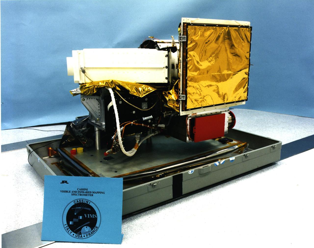
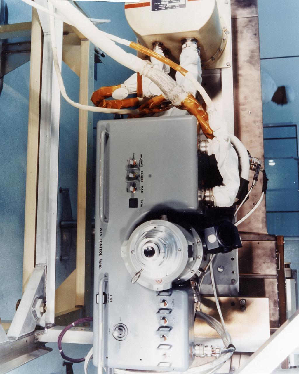
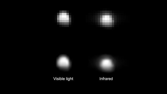
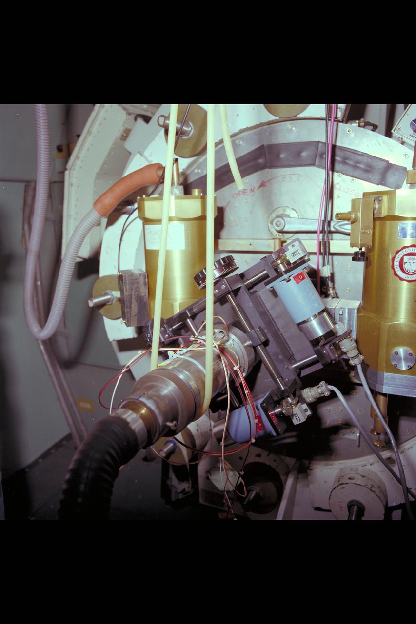
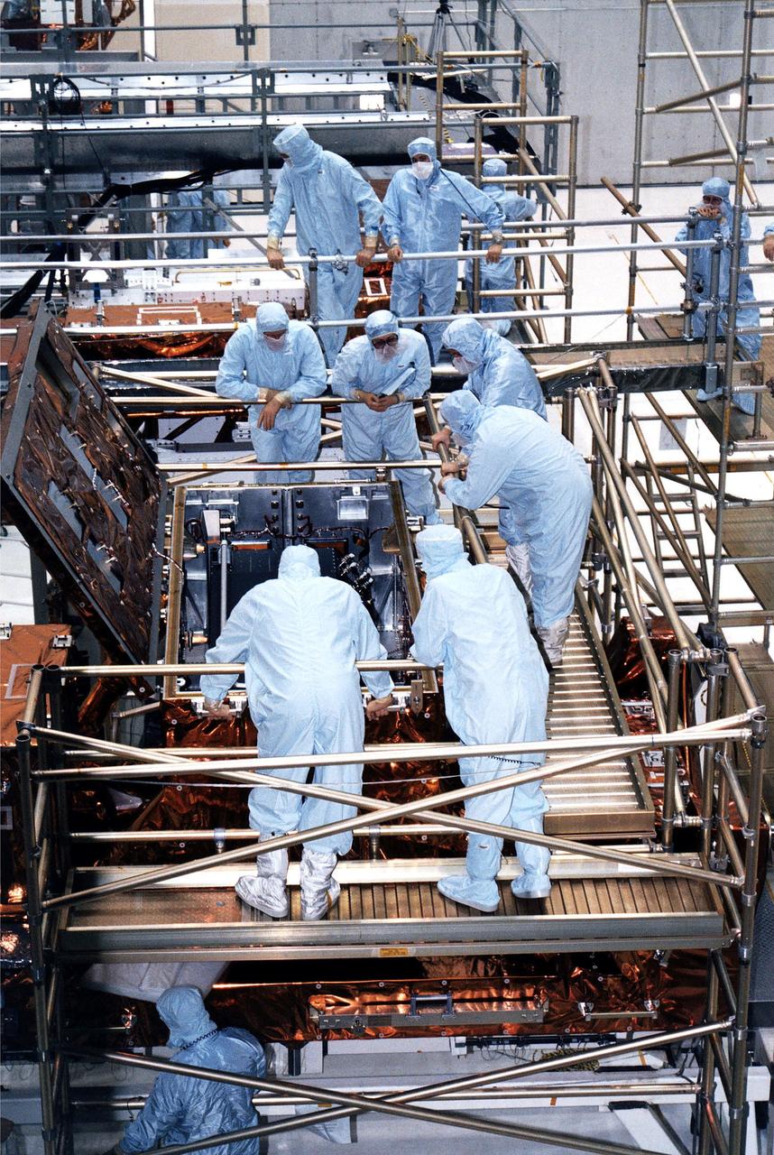
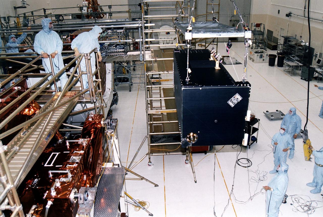
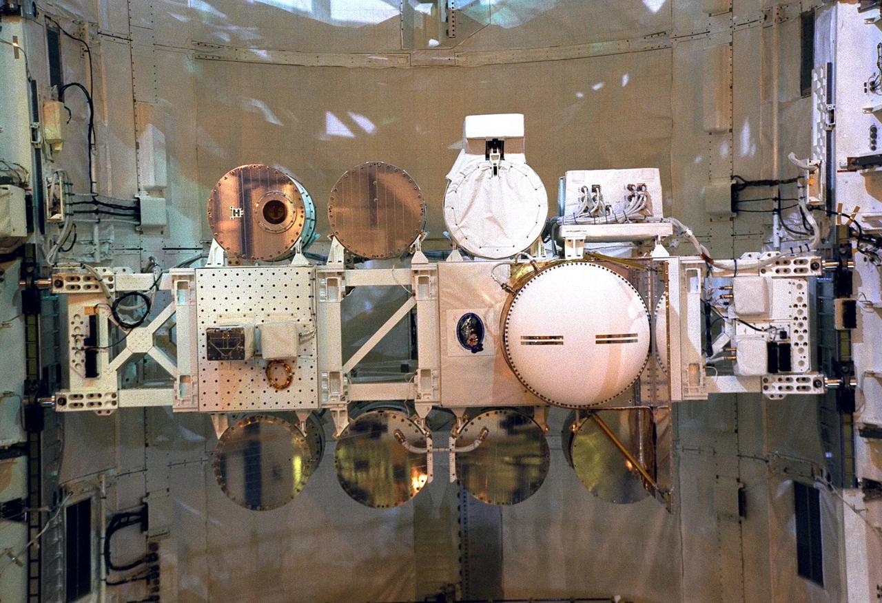
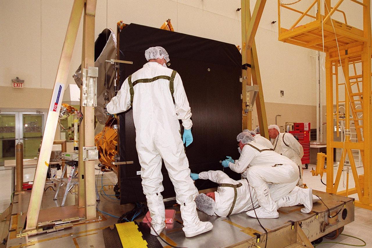
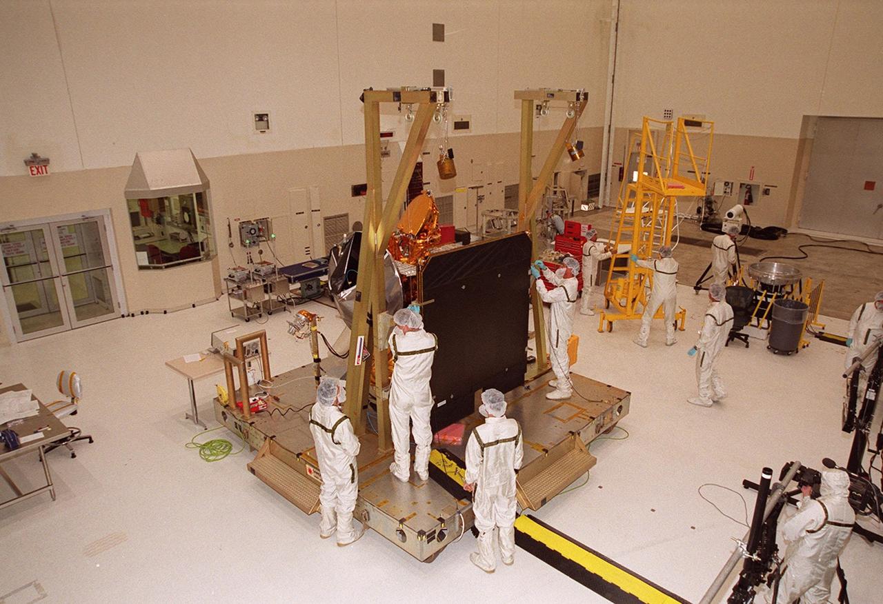
This image shows the visual and infrared mapping spectrometer instrument just before it was attached to NASA Cassini spacecraft. Cassini launched in 1997 and has been exploring the Saturn system since 2004.
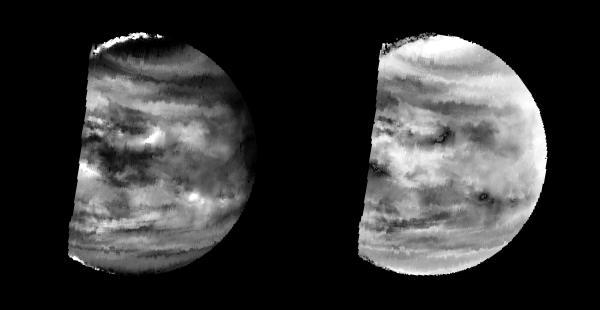
This image is a false color version of a near infrared map of lower level clouds on the night side of Venus, obtained by the Near Infrared Mapping Spectrometer aboard NASA's Galileo spacecraft as it approached the planet Feb. 10, 1990. http://photojournal.jpl.nasa.gov/catalog/PIA00112
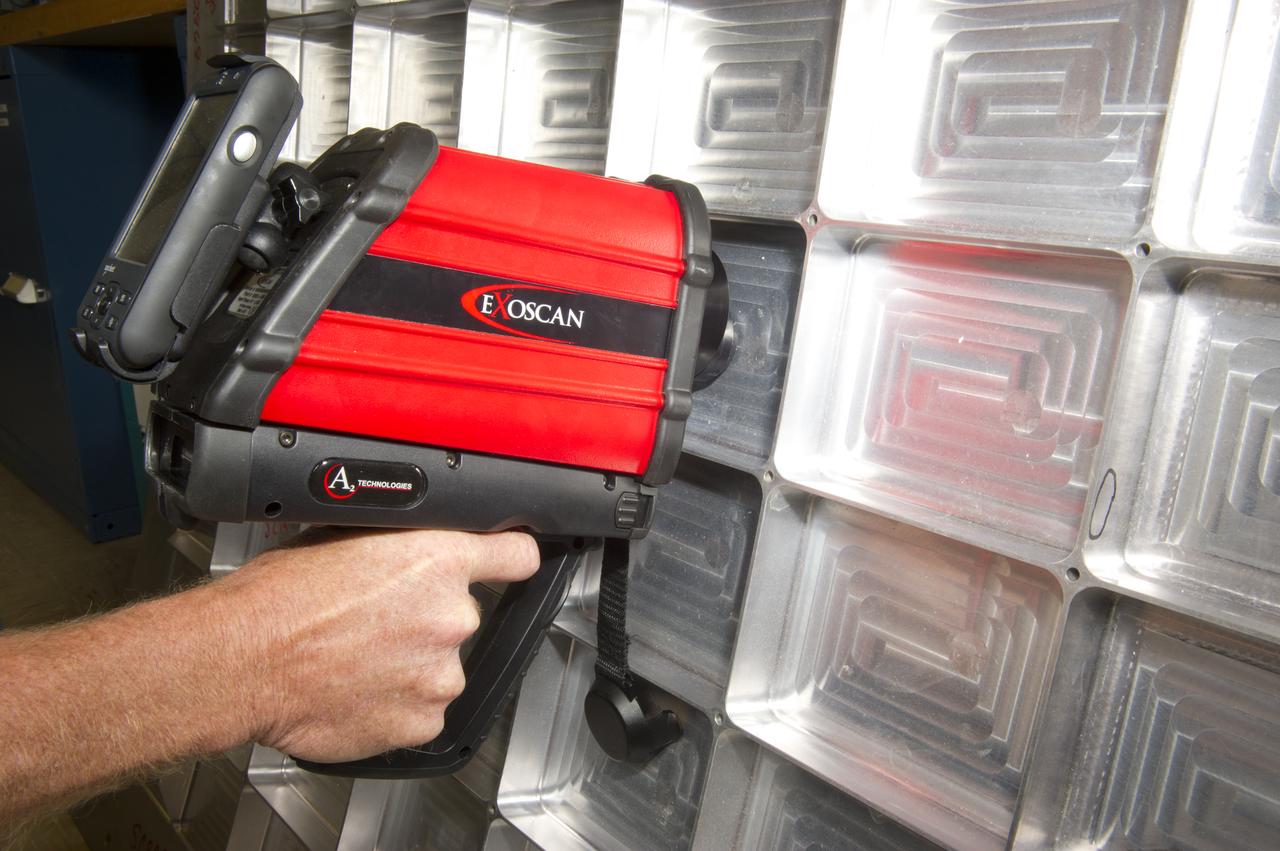
PORTABLE FOURIER TRANSFORM INFRARED (FTIR) SPECTROMETER FOR IN-PROCESS SURFACE INSPECTION.

This image from NASA Dawn spacecraft shows Dawn visible and infrared spectrometer image, overlain on top of a framing camera image of the same region on asteroid Vesta.
The active volcano Prometheus on Jupiter moon Io was imaged by NASA Galileo spacecraft during the close flyby of Io on Oct.10, 1999. The spectrometer can detect active volcanoes on Io by measuring their heat in the near-infrared wavelengths.
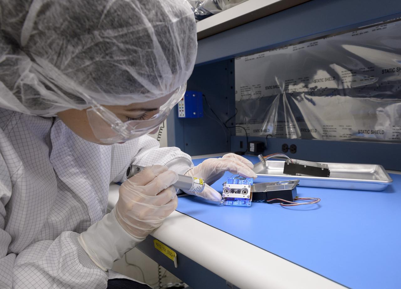
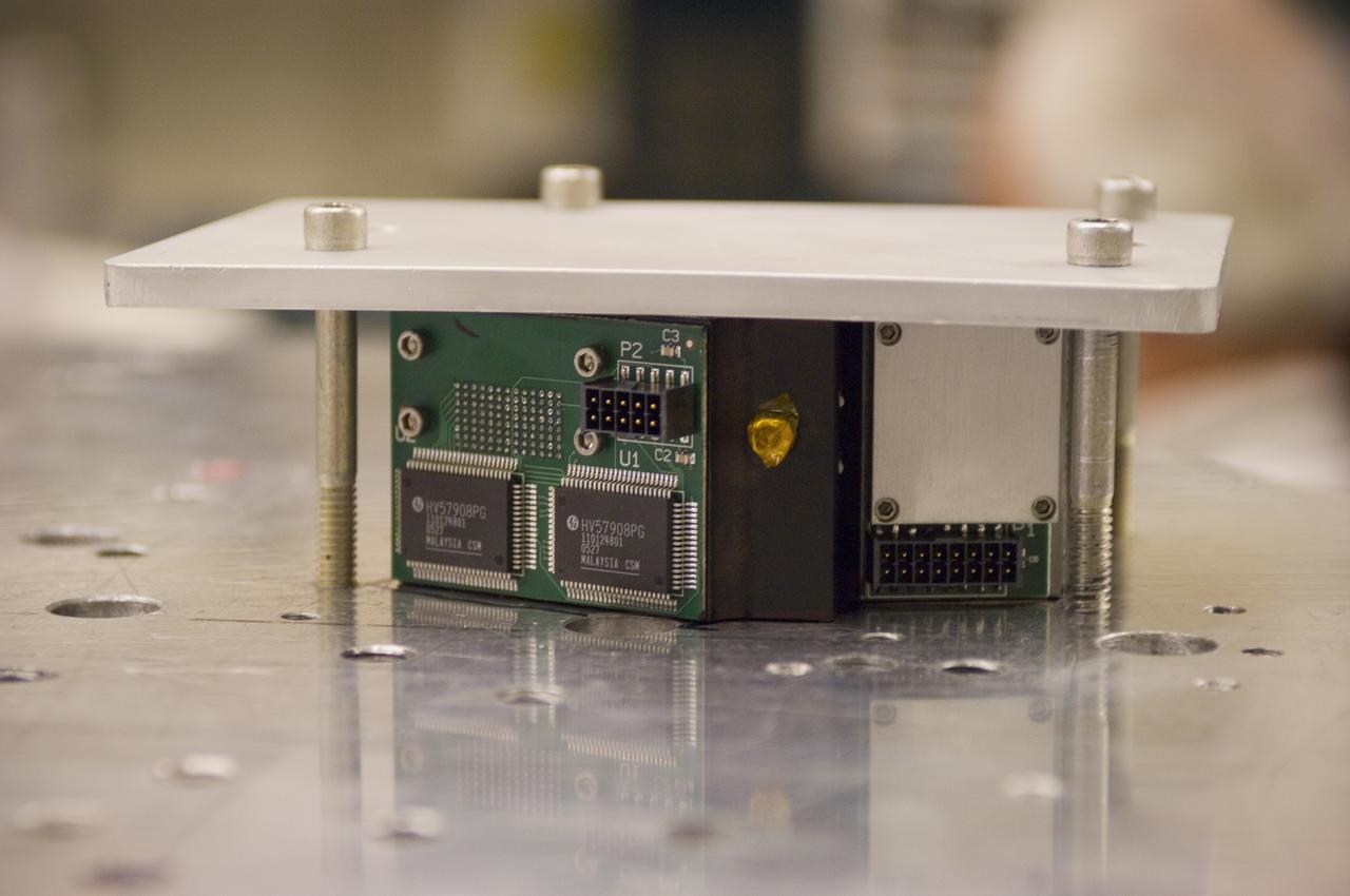
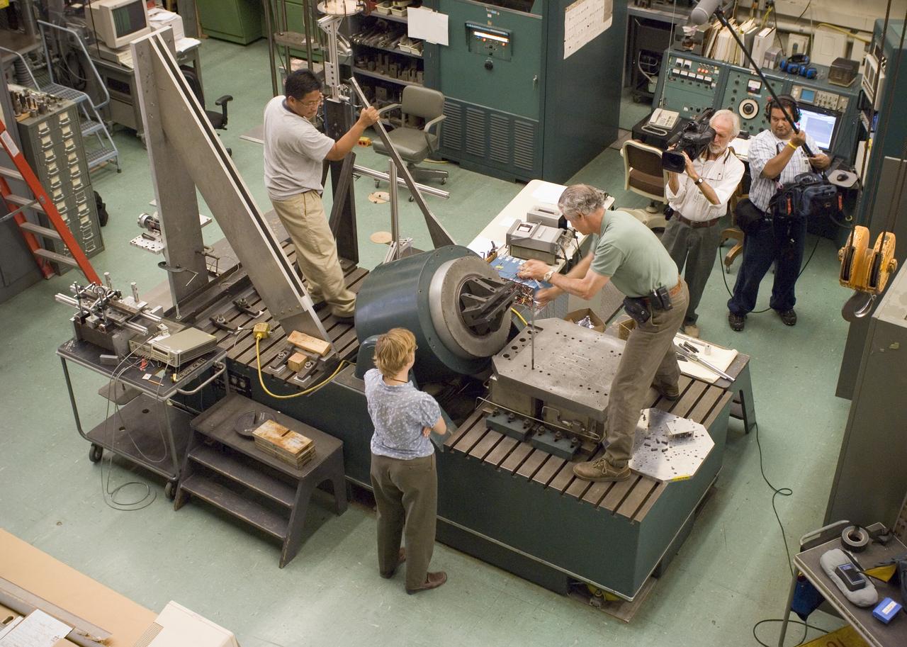
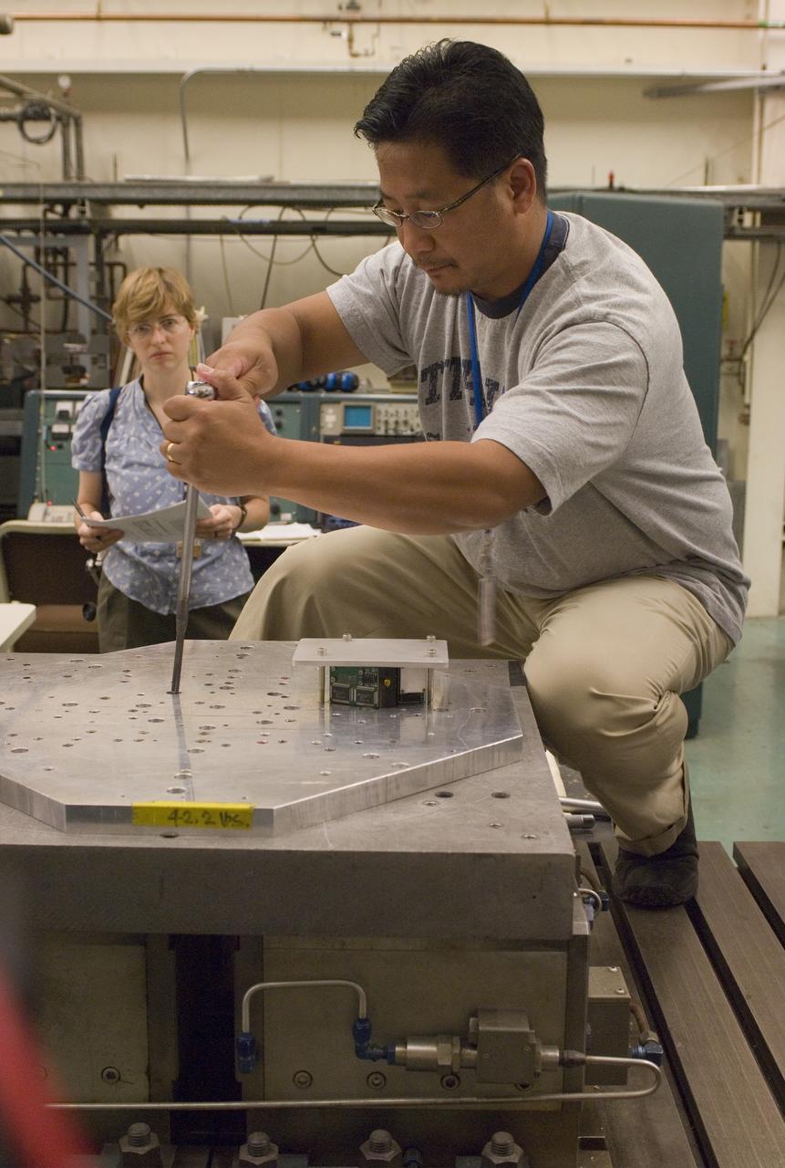
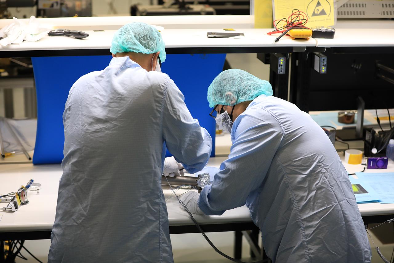
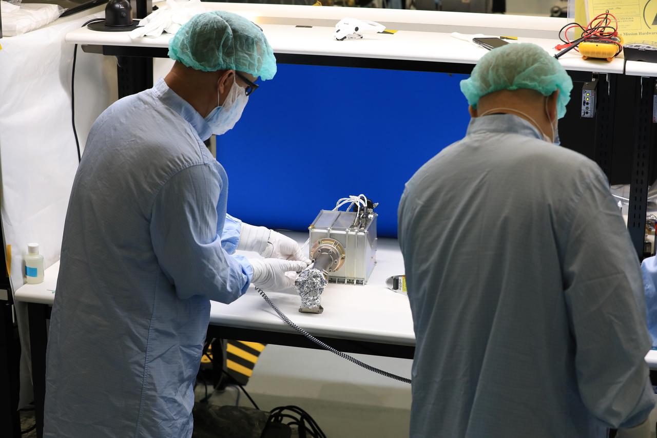
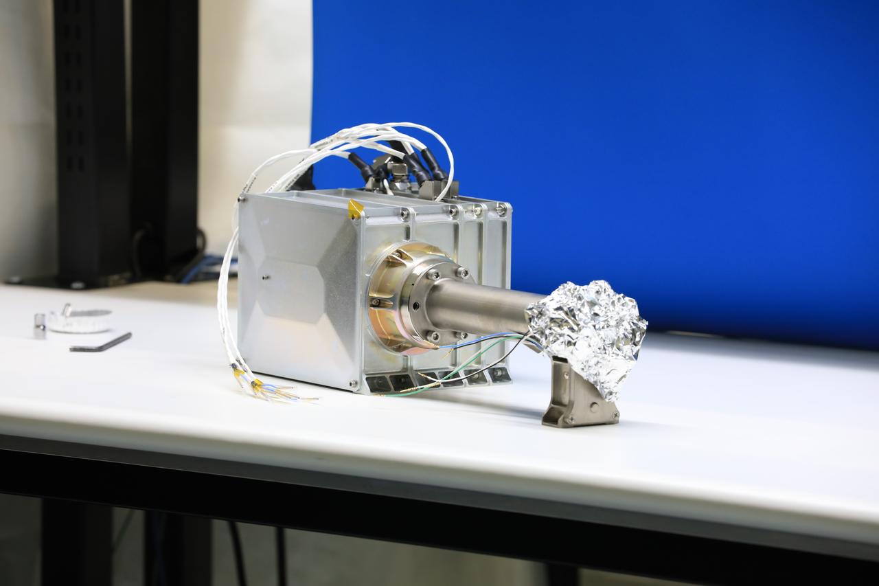
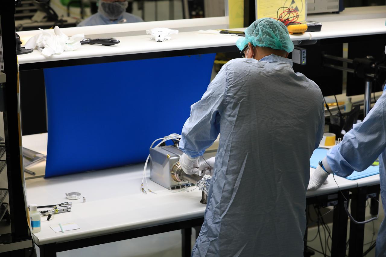
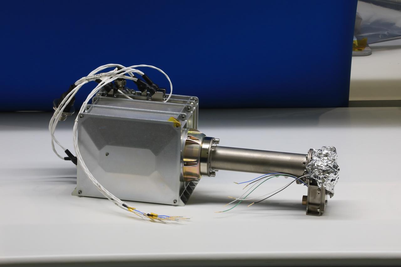
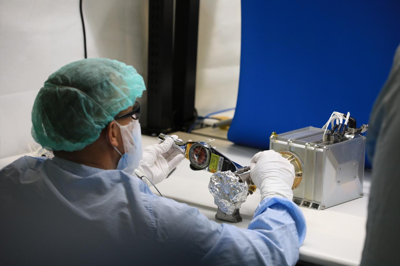
Near InfraRed Volatiles Spectrometer System (NIRVSS) engineering build in Ames N-213 Laboratory with Amanda Cook. The NIRVSS will fly on the Volatiles Investigating Polar Exploration Rover, or VIPER in its search for water on the south pole of the moon.
This 1970 photograph shows Skylab's Infrared Spectrometer Viewfinder Tracking System, a major component of an Earth Resources Experiment Package (EREP). It was designed to evaluate Earth resources sensors for specific regions of the the visible and infrared spectra and assess the value of real time identification of ground sites. The overall purpose of the EREP was to test the use of sensors that operated in the visible, infrared, and microwave portions of the electromagnetic spectrum to monitor and study Earth resources. The Marshall Space Flight Center had program management responsibility for the development of Skylab hardware and experiments.
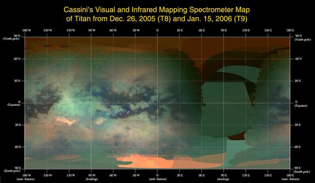
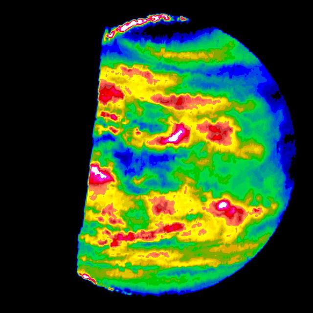
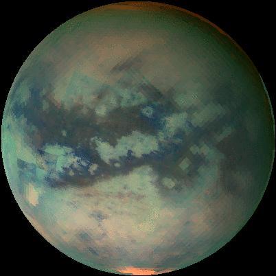
This global infrared map of Titan was composed with data from Cassini visual and infrared mapping spectrometer taken during the last two Titan flybys
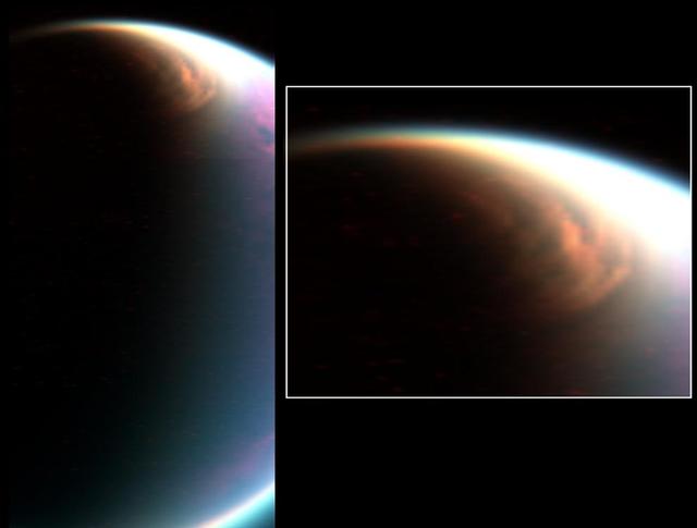
Cassini visual and infrared mapping spectrometer has imaged a huge cloud system covering the north pole of Titan
This movie of Titan shows data taken with Cassini visual and infrared mapping spectrometer during the last three flybys of Titan
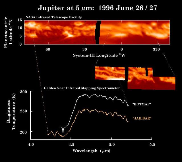
These observations of Jupiter equator in thermal heat emission were made by NASA Infrared Telescope Facility top panel within hours of the Near-Infrared Mapping Spectrometer NIMS instrument image middle inset and the spectra bottom.

NASA Dawn spacecraft used its Visible and Infrared Imaging Spectrometer instrument to produce these three different composite images of the same region of asteroid Vesta surface.
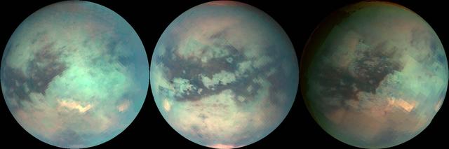
The three mosaics shown here were composed with data from Cassini visual and infrared mapping spectrometer taken during the last three Titan flybys
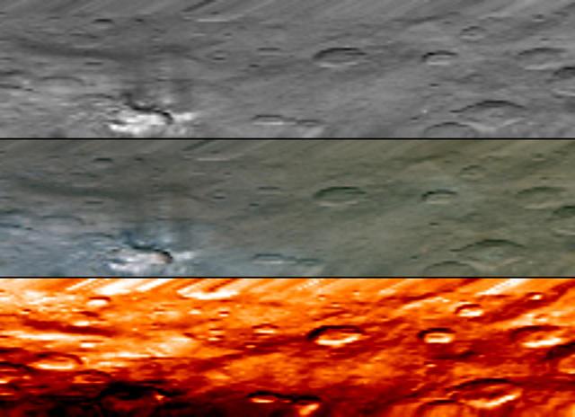
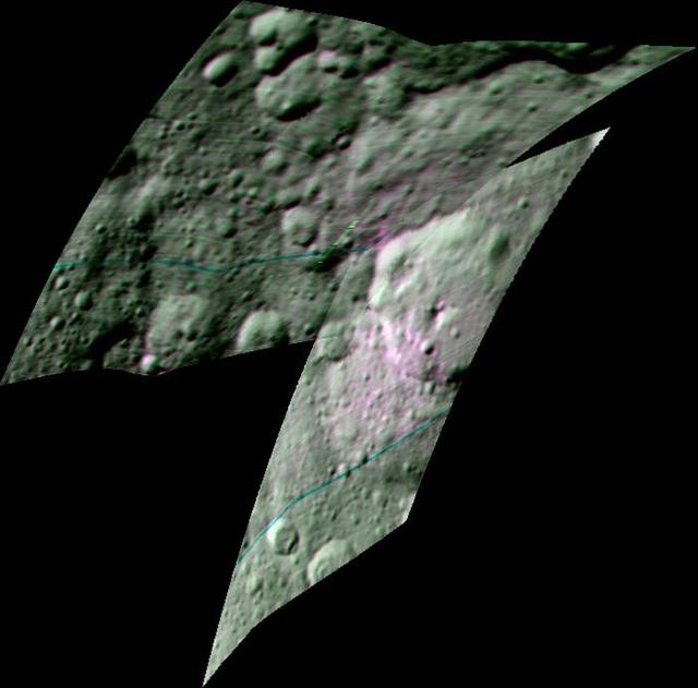
These images of Tarpeia crater, near the south pole of the giant asteroid Vesta, were obtained by the visible and infrared mapping spectrometer on NASA Dawn spacecraft.
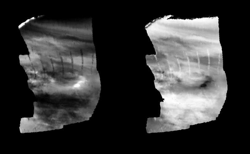
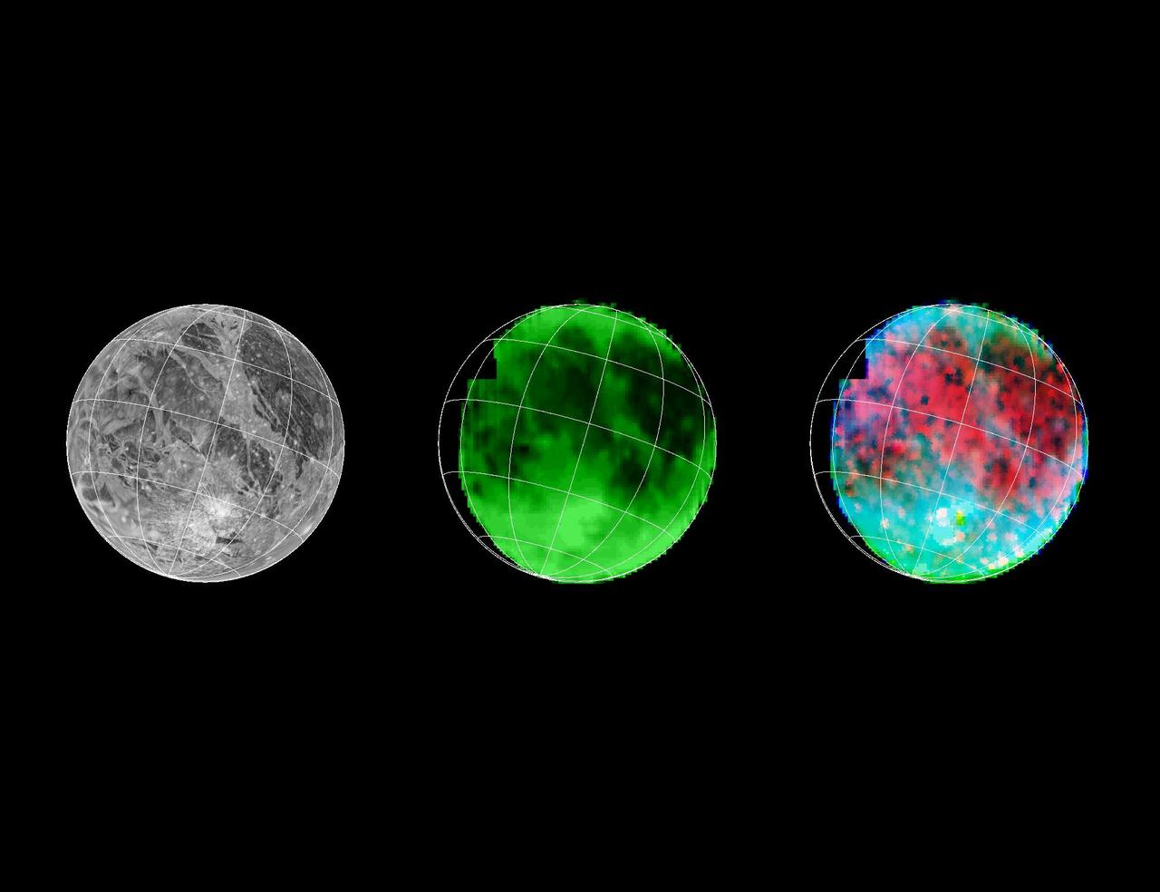
These images are two versions of a near-infrared map of lower-level clouds on the night side of Venus, obtained by the Near Infrared Mapping Spectrometer aboard NASA Galileo spacecraft as it approached the planet February 10, 1990. http://photojournal.jpl.nasa.gov/catalog/PIA00222
These images are two versions of a near-infrared map of lower-level clouds on the night side of Venus, obtained by the Near Infrared Mapping Spectrometer aboard NASA Galileo spacecraft as it approached the planet February 10, 1990. http://photojournal.jpl.nasa.gov/catalog/PIA00221

Astronomers using the Hubble Space Telescope (HST) have identified what may be the most luminous star known; a celestial mammoth that releases up to 10-million times the power of the Sun and is big enough to fill the diameter of Earth's orbit. The star unleashes as much energy in six seconds as our Sun does in one year. The image, taken by a UCLA-led team with the recently installed Near-Infrared Camera and Multi-Object Spectrometer (NICMOS) aboard the HST, also reveals a bright nebula, created by extremely massive stellar eruptions. The UCLA astronomers estimate that the star, called the Pistol Star, (for the pistol shaped nebula surrounding it), is approximately 25,000 light-years from Earth, near the center of our Milky Way galaxy. The Pistol Star is not visible to the eye, but is located in the direction of the constellation Sagittarius, hidden behind the great dust clouds along the Milky Way

Crew chief Darin Whittington and mechanic Edwin Flores watch as mechanic Francisco Rodriguez works on a mounting bolt to secure the Airborne Visible/Infrared Imaging Spectrometer (AVIRIS) instrument into a NASA ER-2 high-altitude aircraft at NASA’s Armstrong Flight Research Center in Edwards, California, on Wednesday, March 11, 2026. The installation helped enabled the Geological Earth Mapping Experiment (GEMx) airborne science mission, which began on March 31, 2026.

Mechanic Francisco Rodriguez and crew chief Darin Whittington installed the Airborne Visible/Infrared Imaging Spectrometer (AVIRIS) instrument into a NASA ER-2 high-altitude aircraft at NASA’s Armstrong Flight Research Center in Edwards, California, on Wednesday, March 11, 2026. The installation helped enabled the Geological Earth Mapping Experiment (GEMx) airborne science
This colorized image from the visible and infrared mapping spectrometer onboard NASA Dawn spacecraft shows temperature variations at Tarpeia crater, near the south pole of the giant asteroid Vesta.
This image, combining data from the imaging science subsystem and composite infrared spectrometer aboard NASA Cassini spacecraft, shows pockets of heat appearing along one of the mysterious fractures in the south polar region of Saturn moon Enceladus

The Culann Patera volcano on Jupiter moon Io was observed by the near-infrared mapping spectrometer instrument onboard NASA Galileo spacecraft during its Io flyby on Nov. 25, 1999.
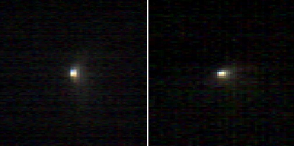
On June 8, 2011, the visible and infrared mapping spectrometer aboard NASA Dawn spacecraft captured the instrument first images of Vesta that are larger than a few pixels, from a distance of about 218,000 miles 351,000 kilometers.
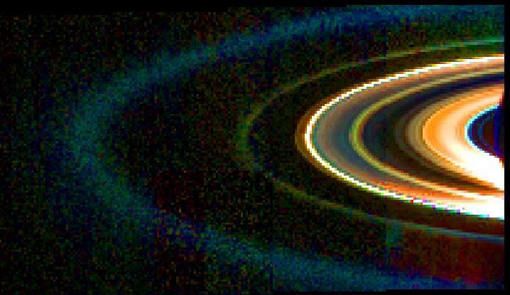
This mosaic of Saturn rings was acquired by NASA Cassini visual and infrared mapping spectrometer instrument on Sept. 15, 2006, while the spacecraft was in the shadow of the planet looking back towards the rings
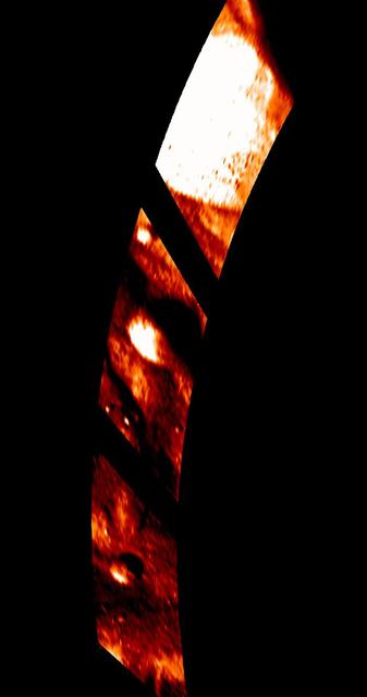
This image of Loki Patera on Jupiter volcanic moon Io shows data taken by the near-infrared mapping spectrometer onboard NASA Galileo spacecraft during its Io flyby on Oct. 10, 1999.
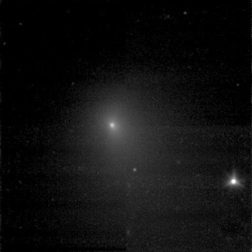
These two infrared images of comet C/2013 A1 Siding Spring were taken by the Compact Reconnaissance Imaging Spectrometer for Mars CRISM aboard NASA Mars Reconnaissance Orbiter on Oct. 19, 2014.
This visual and infrared mapping spectrometer image captured by NASA Cassini spacecraft of Saturn moon Enceladus, shows the dark cracks at the south pole dubbed tiger stripes for their distinct stripe-like appearance.
he visible and infrared mapping spectrometer aboard NASA Dawn spacecraft acquired this set of images during the high-altitude mapping orbit phase at about 420 miles 680 kilometers above the surface of asteroid Vesta.
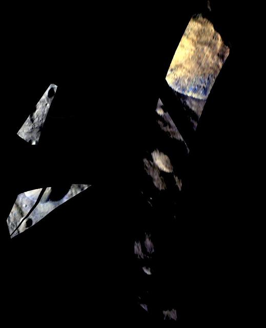
Callisto southern hemisphere was imaged by both the Near Infrared Mapping Spectrometer NIMS and the Solid State Imaging SSI instrument during NASA Galileo eighth orbit of Jupiter. This is a mosaic combining both views.

Taking its first peek at Uranus, NASA Hubble Space Telescope Near Infrared Camera and Multi-Object Spectrometer NICMOS detected six distinct clouds in images taken July 28,1997.
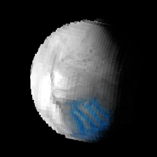
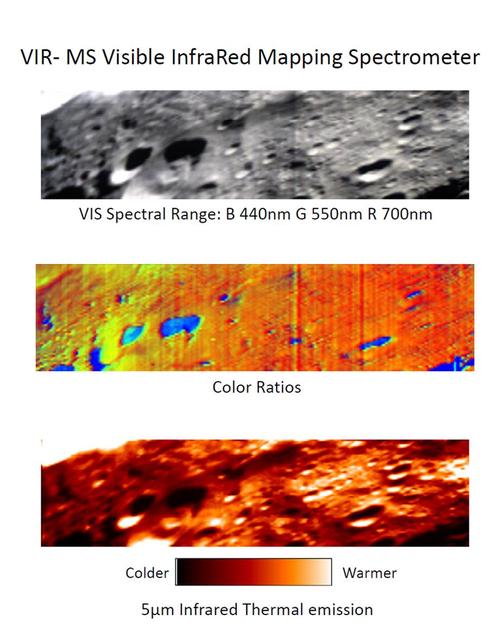
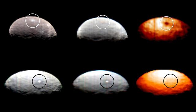
Images from Dawn's visible and infrared mapping spectrometer (VIR) show a portion of Ceres' cratered northern hemisphere, taken on May 16, 2015. From top to bottom, the views include a black-and-white image, a true-color view and a temperature image. The true-color view contains reddish dots that are image artifacts, which are not part of Ceres' surface. These images were taken at a distance of 4,500 miles (7,300 kilometers) from Ceres. They have a resolution of 1.1 miles (1.8 kilometers) per pixel. The temperature image is derived from data in the infrared light range. The lightest areas are the hottest and the darkest are the coolest. http://photojournal.jpl.nasa.gov/catalog/PIA19571
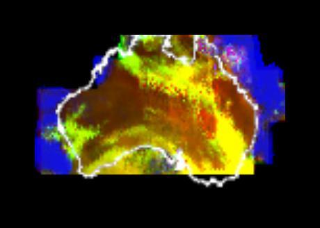
This multispectral map of Australia and surrounding seas was obtained by NASA’s Galileo spacecraft Near Infrared Mapping Spectrometer shortly after closest approach on Dec. 8, 1990 from an altitude of about 50,000 miles. http://photojournal.jpl.nasa.gov/catalog/PIA00227
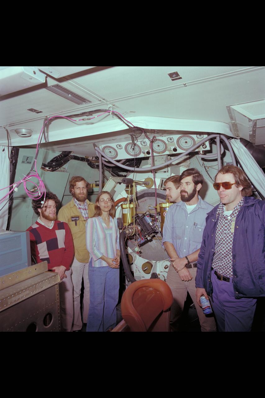
C-141 Circular Variable Filter Spectrometer & Yerkes Infrared (Group Photo)
C-141 Circular Variable Filter Spectrometer & Yerkes Infrared (Group Photo)
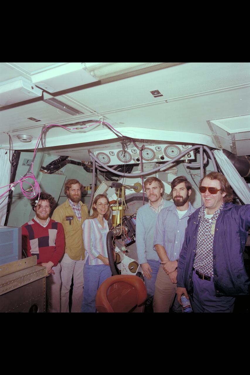
C-141 Circular Variable Filter Spectrometer & Yerkes Infrared (Group Photo)
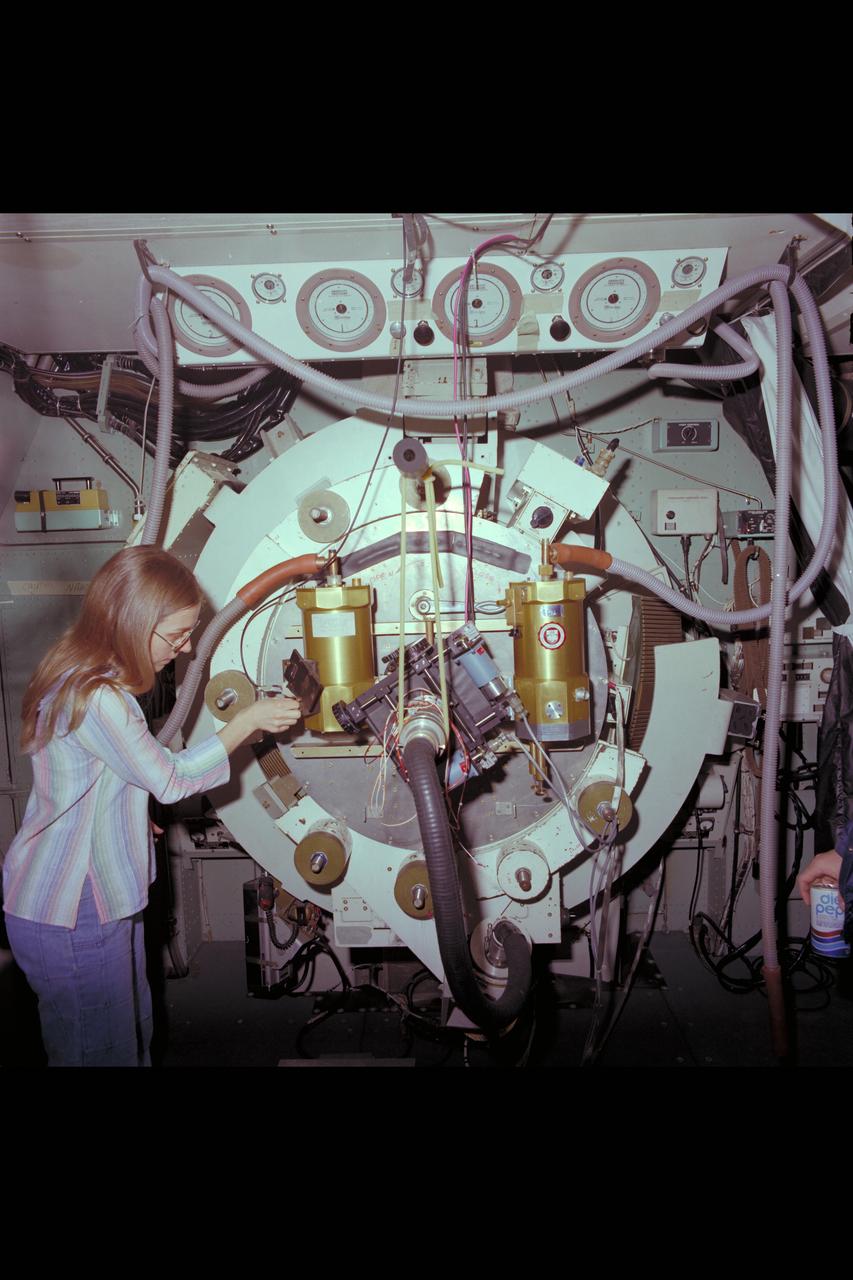
C-141 Circular Variable Filter Spectrometer & Yerkes Infrared

This mosaic from NASA Dawn spacecraft shows asteroid Vesta southern hemisphere lower part of the image and equatorial regions upper part of the image.
LCROSS (Lunar Crater Observation Sensing Satellite) Near InfraRed Spectrometer shake test in Ames N-244 high bay EEL Lab - Spectrometer on shake table
LCROSS (Lunar Crater Observation Sensing Satellite) Near InfraRed Spectrometer shake test in Ames N-244 high bay EEL Lab - Spectrometer on shake table
LCROSS (Lunar Crater Observation Sensing Satellite) Near InfraRed Spectrometer shake test in Ames N-244 high bay EEL Lab - Spectrometer on shake table
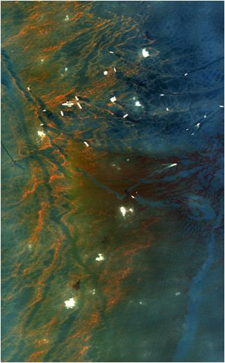
This image from NASA Airborne Visible/Infrared Imaging Spectrometer instrument AVIRIS was collected on May 17, 2010, over the site of the Deepwater Horizon BP oil spill disaster. In the image, crude oil on the surface appears orange to brown.
This montage of images, made from data obtained by Cassini's visual and infrared mapping spectrometer, shows the location on Saturn where the NASA spacecraft entered Saturn's atmosphere on Sept. 15, 2017. This view shows Saturn in the thermal infrared, at a wavelength of 5 microns. Here, the instrument is sensing heat coming from Saturn's interior, in red. Clouds in the atmosphere are silhouetted against that inner glow. This location -- the site of Cassini's atmospheric entry -- was at this time on the night side of the planet, but would rotate into daylight by the time Cassini made its final dive into Saturn's upper atmosphere, ending its remarkable 13-year exploration of Saturn. Both an annotated version and an animation are available at https://photojournal.jpl.nasa.gov/catalog/PIA21896
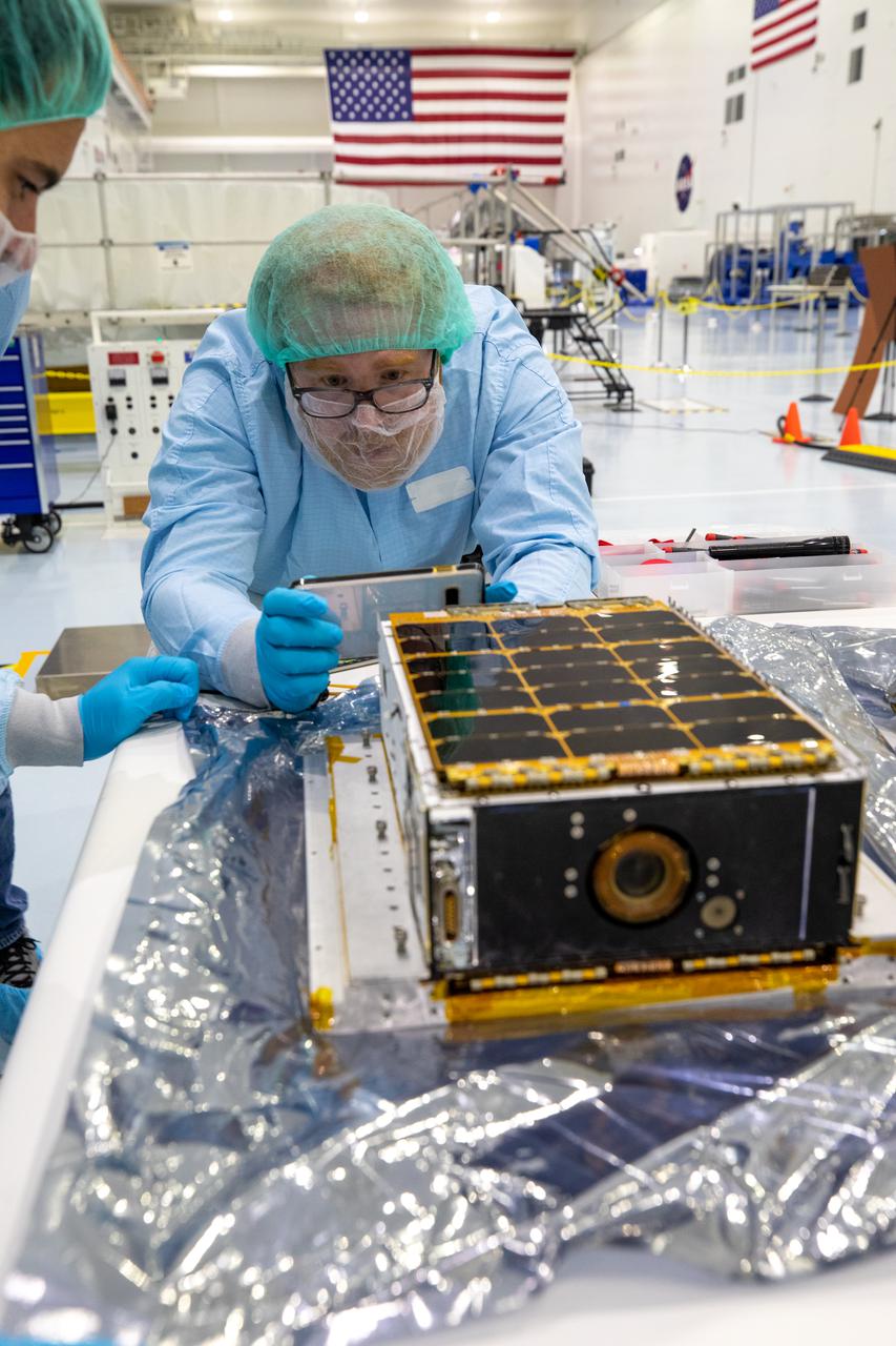
This image shows one of two shoebox-size satellites that make up NASA's Polar Radiant Energy in the Far-InfraRed Experiment (PREFIRE) mission. PREFIRE will measure the amount of heat Earth emits into space from two of the coldest, most remote regions on the planet. Data from the cube satellites, or CubeSats, will improve computer models researchers use to predict how Earth's ice, seas, and weather will change in a warming world. Earth absorbs a lot of the Sun's energy at the tropics, and weather and ocean currents transport that heat to the poles. Ice, snow, clouds, and other parts of the polar environment emit the heat into space, much of it in the form of far-infrared radiation. The difference between this incoming and outgoing heat helps to determines the planet's temperature and drives a dynamic system of climate and weather. But far-infrared emissions at the poles have never been systematically measured. This is where PREFIRE comes in. The crucial instrument on each spacecraft is a thermal infrared spectrometer, which will measure wavelengths of light in the far-infrared range. The mission will help researchers gain a clearer understanding of when and where Earth's poles emit far-infrared radiation, as well as how atmospheric water vapor and clouds influence the amount that escapes to space. https://photojournal.jpl.nasa.gov/catalog/PIA26186
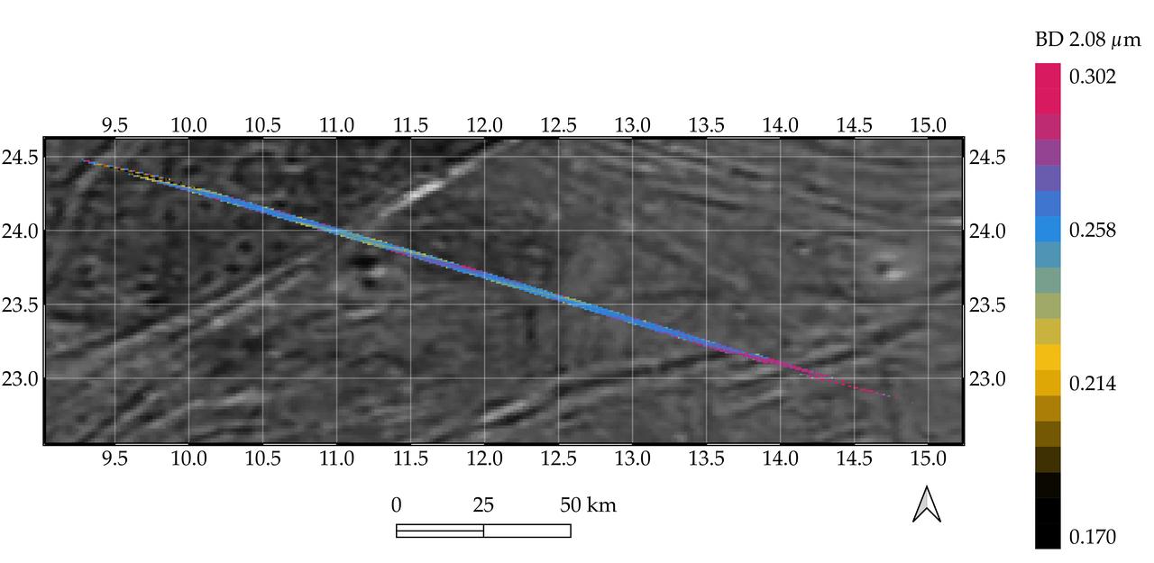
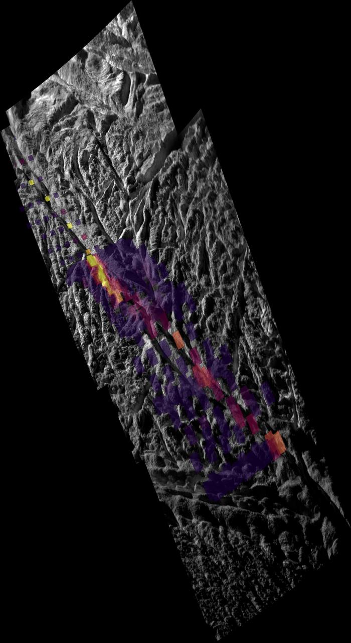
Processed data from the Jovian InfraRed Auroral Mapper (JIRAM) spectrometer aboard NASA's Juno mission is superimposed on a mosaic of optical images from the agency's Galileo and Voyager spacecraft that shows grooved terrain on Jupiter's moon Ganymede. This composite image covers a portion of Phrygia Suclus, northeast of Nanshe Catena, on Ganymede. The data was taken by Juno during its June 7, 2021, flyby of the icy moon. The JIRAM data is represented by the colored line running from the upper left to lower right in the graphic. The line depicts an increase in intensity of the spectral signature of a non-ice compound, possibly ammonium chloride, in the groove at the lower right of the image. JIRAM "sees" infrared light not visible to the human eye. It measures heat radiated from the planet at an infrared wavelengths. https://photojournal.jpl.nasa.gov/catalog/PIA26075
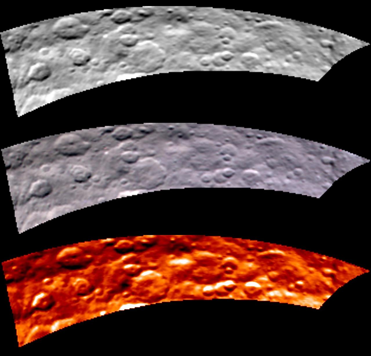
This image, from NASA Dawn visible and infrared mapping spectrometer VIR, highlights a bright region on Ceres known as Haulani, named after the Hawaiian plant goddess. Each row shows Ceres' surface at different wavelengths. On top is a black-and-white image; in the middle is a true-color image, and the bottom is in thermal infrared, where brighter colors represent higher temperatures and dark colors correspond to colder temperatures. The three images appear slightly flattened in the y-axis and smeared in the upper part due to the motion of the spacecraft. These images were taken at a distance of 2,700 miles (4,400 kilometers) from Ceres and have a resolution of about 0.6 miles (1 kilometer) per pixel. They were produced on June 6, 2015. http://photojournal.jpl.nasa.gov/catalog/PIA19608

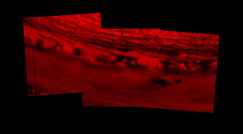
NASA's Airborne Visible Infrared Imaging Spectrometer instrument (AVIRIS), flying aboard a NASA Armstrong Flight Research Center high-altitude ER-2 aircraft, observed wildfires burning in Southern California on Dec. 5-7, 2017. AVIRIS is an imaging spectrometer that observes light in visible and infrared wavelengths, measuring the full spectrum of radiated energy. Unlike regular cameras with three colors, AVIRIS has 224 spectral channels, measuring contiguously from the visible through the shortwave infrared. Data from these flights, compared against measurements acquired earlier in the year, show many ways this one instrument can improve both our understanding of fire risk and the response to fires in progress. The top row in this image compilation shows pre-fire data acquired from June 2017. At top left is a visible-wavelength image similar to what our own eyes would see. The top middle image is a map of surface composition based on analyzing the full electromagnetic spectrum, revealing green vegetated areas and non-photosynthetic vegetation that is potential fuel as well as non-vegetated surfaces that may slow an advancing fire. The image at top right is a remote measurement of the water in tree canopies, a proxy for how much moisture is in the vegetation. The bottom row in the compilation shows data acquired from the Thomas fire in progress in December 2017. At bottom left is a visible wavelength image. The bottom middle image is an infrared image, with red at 2,250 nanometers showing fire energy, green at 1,650 nanometers showing the surface through the smoke, and blue at 1,000 nanometers showing the smoke itself. The image at bottom right is a fire temperature map using spectroscopic analysis to measure fire thermal emission recorded in the AVIRIS spectra. https://photojournal.jpl.nasa.gov/catalog/PIA22194
LCROSS (Lunar Crater Observation Sensing Satellite) Near InfraRed Spectrometer shake test in Ames N-244 high bay EEL Lab - with Lynn Hofland
LCROSS (Lunar Crater Observation Sensing Satellite) Near InfraRed Spectrometer shake test in Ames N-244 high bay EEL Lab - with Lynn Hofland
LCROSS (Lunar Crater Observation Sensing Satellite) Near InfraRed Spectrometer shake test in Ames N-244 high bay EEL Lab - with Lynn Hofland
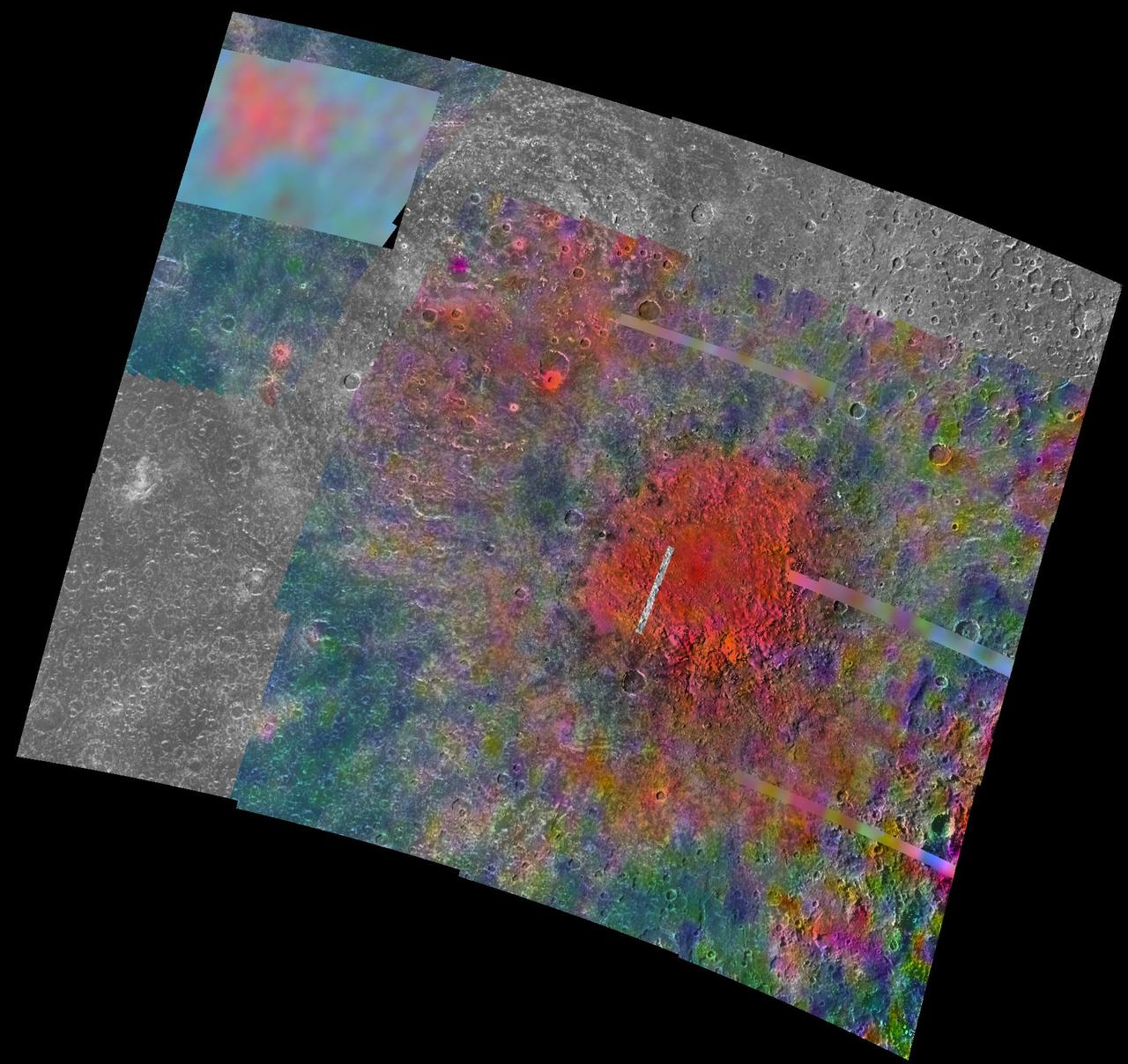
This enhanced color composite image from Dawn's visible and infrared mapping spectrometer shows the area around Ernutet Crater on Ceres. The instrument detected the evidence of organic materials in this area, as reported in a 2017 study in the journal Science. In this view, areas that appear pink with respect to the background appear to be rich in organics, and green areas are where organic material appears to be less abundant. Light with a wavelength of 2000 nanometers is shown in blue, 3400 nanometers is shown in green and 1700 nanometers is shown in red. http://photojournal.jpl.nasa.gov/catalog/PIA21420
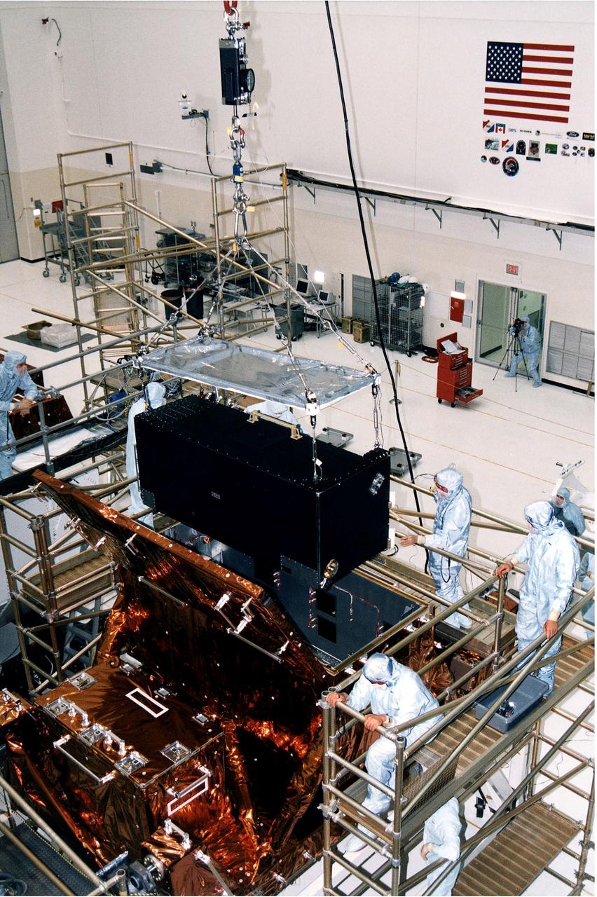
KENNEDY SPACE CENTER, FLA. - Workers in KSC's Vertical Processing Facility lower the Near Infrared Camera and Multi-Object Spectrometer (NICMOS) into the Second Axial Carrier. NICMOS is one of two new scientific instruments that will replace two outdated instruments on the Hubble Space Telescope (HST). NICMOS will provide HST with the capability for infrared imaging and spectroscopic observations of astronomical targets. The refrigerator-sized NICMOS is HST's first cryogenic instrument -- its sensitive infrared detectors must operate at very cold temperatures of minus 355 degrees Fahrenheit or 58 derees Kelvin. NICMOS will be installed in Hubble during STS-82, the second Hubble Space Telescope servicing mission. Liftoff is targeted Feb. 11 aboard Discovery with a crew of seven.
KENNEDY SPACE CENTER, FLA. - Workers in KSC's Vertical Processing Facility lower the Near Infrared Camera and Multi-Object Spectrometer (NICMOS) into the Second Axial Carrier. NICMOS is one of two new scientific instruments that will replace two outdated instruments on the Hubble Space Telescope (HST). NICMOS will provide HST with the capability for infrared imaging and spectroscopic observations of astronomical targets. The refrigerator-sized NICMOS also is HST's first cryogenic instrument — its sensitive infrared detectors must operate at very cold temperatures of minus 355 degrees Fahrenheit or 58 degrees Kelvin. NICMOS will be installed in Hubble during STS-82, the second Hubble Space Telescope servicing mission. Liftoff is targeted Feb. 11 aboard Discovery with a crew of seven.
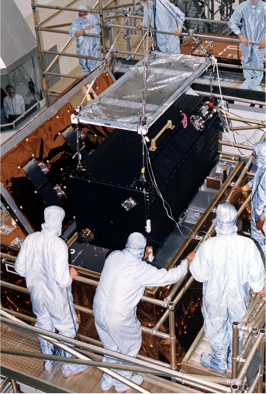
KENNEDY SPACE CENTER, FLA. - Workers in KSC's Vertical Processing Facility inspect the Near Infrared Camera and Multi-Object Spectrometer (NICMOS) on its handling fixture. NICMOS is one of two new scientific instruments that will replace two outdated instruments on the Hubble Space Telescope (HST). NICMOS will provide HST with the capability for infrared imaging and spectroscopic observations of astronomical targets. The refrigerator-sized NICMOS also is HST's first cryogenic instrument — its sensitive infrared detectors must operate at very cold temperatures of minus 355 degrees Fahrenheit or 58 degrees Kelvin. NICMOS will be installed in Hubble during STS-82, the second Hubble Space Telescope servicing mission. Liftoff is targeted Feb. 11 aboard Discovery with a crew of seven.
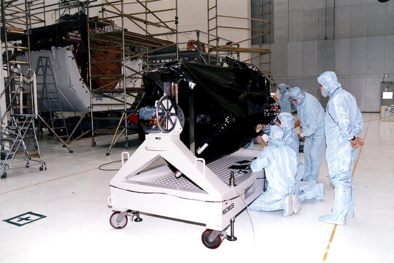
KENNEDY SPACE CENTER, FLA. - STS-82 crew members and workers at KSC's Vertical Processing Facility get a final look at the Near Infrared Camera and Multi-Object Spectrometer (NICMOS) in its flight configuration for the STS-82 mission. The crew is participating in the Crew Equipment Integration Test (CEIT). NICMOS is one of two new scientific instruments that will replace two outdated instruments on the Hubble Space Telescope (HST). NICMOS will provide HST with the capability for infrared imaging and spectroscopic observations of astronomical targets. The refrigerator-sized NICMOS also is HST's first cryogenic instrument - its sensitive infrared detectors must operate at very cold temperatures of minus 355 degrees Fahrenheit or 58 degrees Kelvin. NICMOS will be installed in Hubble during STS-82, the second Hubble Space Telescope servicing mission. Liftoff is scheduled Feb. 11 aboard Discovery with a crew of seven.
KENNEDY SPACE CENTER, FLA. - Workers in KSC's Vertical Processing Facility lift the Near Infrared Camera and Multi-Object Spectrometer (NICMOS) prior to its installation in the Second Axial Carrier. NICMOS is one of two new scientific instruments that will replace two outdated instruments on the Hubble Space Telescope (HST). NICMOS will provide HST with the capability for infrared imaging and spectroscopic observations of astronomical targets. The refrigerator-sized NICMOS also is HST's first cryogenic instrument — its sensitive infrared detectors must operate at very cold temperatures of minus 355 degrees Fahrenheit or 58 degrees Kelvin. NICMOS will be installed in Hubble during STS-82, the second Hubble Space Telescope servicing mission. Liftoff is targeted Feb. 11 aboard Discovery with a crew of seven.
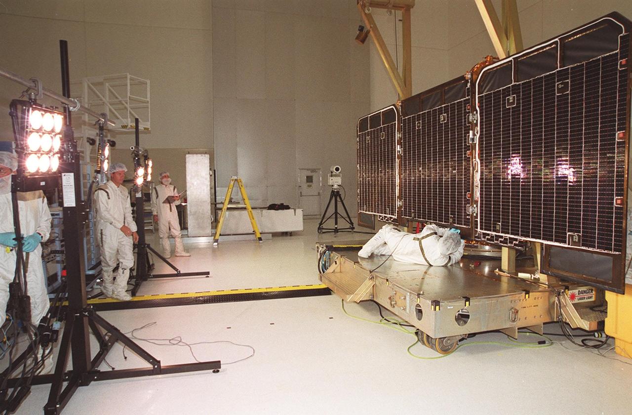
These images were obtained by the Dawn spacecraft on July 23, 2011. The bottom two images are false-color, where different colors represent visible and infrared light wavelengths.
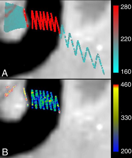
Cassini made a close flyby of Saturn's moon Iapetus on Sept. 10, 2007, and the visual and infrared mapping spectrometer obtained these images during that event. These two images show a higher resolution version of the equatorial region shown in PIA10010. The equatorial region includes the equatorial bulge which shows no differences in these compositions compared to surrounding regions. The color image on the right shows the results of mapping for three components of Iapetus' surface: carbon dioxide that is trapped or adsorbed in the surface (red), water in the form of ice (green), and a newly-discovered effect due to trace amount of dark particles in the ice creating what scientists call Rayleigh scattering (blue). The Rayleigh scattering effect is the main reason why the Earth's sky appears blue. There is a complex transition zone from the dark region, on the right, which is high in carbon dioxide, to the more ice-rich region on the left. Some crater floors are filled with carbon dioxide-rich dark material. As the ice becomes cleaner to the left, the small dark particles become more scattered and increase the Rayleigh scattering effect, again indicative of less than 2 percent dark sub-0.5-micron particles. The visual and infrared mapping spectrometer is like a digital camera, but instead of using three colors, it makes images in 352 colors, or wavelengths, from the ultraviolet to the near-infrared. The many wavelengths produce a continuous spectrum in each pixel, and these spectra measure how light is absorbed by different materials. By analyzing the absorptions expressed in each pixel, a map of the composition at each location on the moon can be constructed. http://photojournal.jpl.nasa.gov/catalog/PIA10011
LCROSS (Lunar Crater Observation Sensing Satellite) Near InfraRed Spectrometer shake test in Ames N-244 high bay EEL Lab - with Kimberly Ennico, Lynn Hofland, Frank Pichay and Discovery Channel video crew

LCROSS (Lunar Crater Observation Sensing Satellite) Near InfraRed Spectrometer shake test in Ames N-244 high bay EEL Lab - with Anthony Colaprete, Ames code SST

LCROSS (Lunar Crater Observation Sensing Satellite) Near InfraRed Spectrometer shake test in Ames N-244 high bay EEL Lab - with Kimberly Ennico, Anthony Colaprete and Lynn Hofland

LCROSS (Lunar Crater Observation Sensing Satellite) Near InfraRed Spectrometer shake test in Ames N-244 high bay EEL Lab - with Kimberly Ennico, Anthony Colaprete and Lynn Hofland
LCROSS (Lunar Crater Observation Sensing Satellite) Near InfraRed Spectrometer shake test in Ames N-244 high bay EEL Lab - with Kimberly Ennico and Anthony Colaprete
LCROSS (Lunar Crater Observation Sensing Satellite) Near InfraRed Spectrometer shake test in Ames N-244 high bay EEL Lab - with Kimberly Ennico, Anthony Colaprete and Lynn Hofland

LCROSS (Lunar Crater Observation Sensing Satellite) Near InfraRed Spectrometer shake test in Ames N-244 high bay EEL Lab - with Lynn Hofland, Ames EEL lab) and Kimberly Ennico, LCROSS payload scientist
LCROSS (Lunar Crater Observation Sensing Satellite) Near InfraRed Spectrometer shake test in Ames N-244 high bay EEL Lab - with Kimberly Ennico and Anthony Colaprete
LCROSS (Lunar Crater Observation Sensing Satellite) Near InfraRed Spectrometer shake test in Ames N-244 high bay EEL Lab - with Frank Pichay, EEL lab
LCROSS (Lunar Crater Observation Sensing Satellite) Near InfraRed Spectrometer shake test in Ames N-244 high bay EEL Lab - with Lynn Hofland, Ames EEL lab) and Kimberly Ennico, LCROSS payload scientist
KENNEDY SPACE CENTER, FLA. -- The final tasks to prepare the Cryogenic Infrared Spectrometers and Telescopes for the Atmosphere-Shuttle Pallet Satellite-2 (CRISTA-SPAS-2) payload for the STS-85 mission are completed aboard Discovery at Launch Complex 39A. The CRISTA is a system of three telescopes and four spectrometers to measure infrared radiation emitted by the Earth’s middle atmosphere. During the 11-day mission, the CRISTA-SPAS-2 free-flying satellite will be deployed from Discovery and retrieved later in the flight. Also onboard the satellite will be the Middle Atmosphere High Resolution Spectrograph Investigation (MAHRSI) to measure ultraviolet radiation emitted and scattered by the Earth’s atmosphere.
KENNEDY SPACE CENTER, FLA. -- Space Shuttle orbiter Discovery's payload bay doors are closed in preparation for the flight of mission STS-85. The payload includes the Cryogenic Infrared Spectrometers and Telescopes for the Atmosphere-Shuttle Pallet Satellite-2 (CRISTA-SPAS-2). The CRISTA is a system of three telescopes and four spectrometers to measure infrared radiation emitted by the Earth’s middle atmosphere. During the 11-day mission, the CRISTA-SPAS-2 free-flying satellite will be deployed from Discovery and retrieved later in the flight. Also onboard the satellite will be the Middle Atmosphere High Resolution Spectrograph Investigation (MAHRSI) to measure ultraviolet radiation emitted and scattered by the Earth’s atmosphere.
KENNEDY SPACE CENTER, FLA. -- The final tasks to prepare the Cryogenic Infrared Spectrometers and Telescopes for the Atmosphere-Shuttle Pallet Satellite-2 (CRISTA-SPAS-2) payload for the STS-85 mission are completed aboard Discovery at Launch Complex 39A. The CRISTA is a system of three telescopes and four spectrometers to measure infrared radiation emitted by the Earth’s middle atmosphere. During the 11-day mission, the CRISTA-SPAS-2 free-flying satellite will be deployed from Discovery and retrieved later in the flight. Also onboard the satellite will be the Middle Atmosphere High Resolution Spectrograph Investigation (MAHRSI) to measure ultraviolet radiation emitted and scattered by the Earth’s atmosphere.
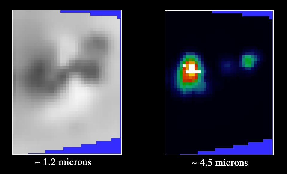
Galileo has eyes that can see more than ours can. By looking at what we call the infrared wavelengths, the NIMS (Near Infrared Mapping Spectrometer) instrument can determine what type and size of material is on the surface of a moon. Here, 3 images of Ganymede are shown. Left: Voyager's camera. Middle: NIMS, showing water ice on the surface. Dark is less water, bright is more. Right: NIMS, showing the locations of minerals in red, and the size of ice grains in shades of blue. http://photojournal.jpl.nasa.gov/catalog/PIA00500
One of the two pictures of Tempel 1 (see also PIA02101) taken by Deep Impact's medium-resolution camera is shown next to data of the comet taken by the spacecraft's infrared spectrometer. This instrument breaks apart light like a prism to reveal the "fingerprints," or signatures, of chemicals. Even though the spacecraft was over 10 days away from the comet when these data were acquired, it detected some of the molecules making up the comet's gas and dust envelope, or coma. The signatures of these molecules -- including water, hydrocarbons, carbon dioxide and carbon monoxide -- can be seen in the graph, or spectrum. Deep Impact's impactor spacecraft is scheduled to collide with Tempel 1 at 10:52 p.m. Pacific time on July 3 (1:52 a.m. Eastern time, July 4). The mission's flyby spacecraft will use its infrared spectrometer to sample the ejected material, providing the first look at the chemical composition of a comet's nucleus. These data were acquired from June 20 to 21, 2005. The picture of Tempel 1 was taken by the flyby spacecraft's medium-resolution instrument camera. The infrared spectrometer uses the same telescope as the high-resolution instrument camera. http://photojournal.jpl.nasa.gov/catalog/PIA02100
This video shows Jupiter as revealed by a powerful telescope and a mid-infrared filter sensitive to the giant planet's tropospheric temperatures and cloud thickness. It combines observations made on Jan. 14, 2017, using the Subaru Telescope in Hawaii. The filter used admits infrared light centered on a wavelength of 8.8 microns. The video includes interpolated frames for smoother apparent motion. The instrument used to take this image is Cooled Mid-Infrared Camera and Spectrometer (COMICS) of the National Astronomical Observatory of Japan's Subaru Telescope on the Maunakea volcano. Animations are available at https://photojournal.jpl.nasa.gov/catalog/PIA21715
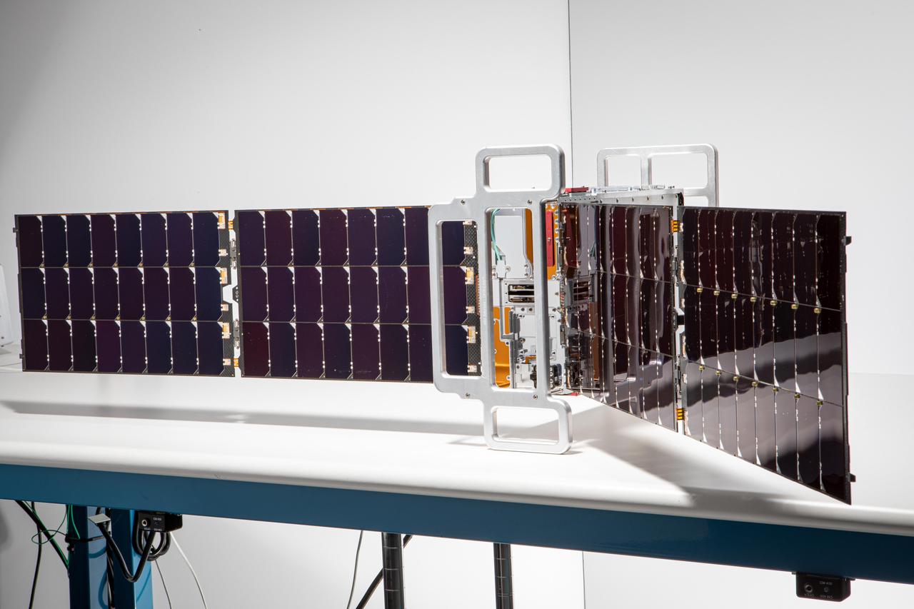
Teams prepare the Lunar IceCube before its installation in the Space Launch System rocket Orion stage adapter at NASA’s Kennedy Space Center in Florida. This small satellite will be deployed from the rocket and will orbit the Moon for six months and search for water and ice with an infrared spectrometer.

S85-E-5096 (15 August 1997) --- The Cryogenic Infrared Spectrometers and Telescopes for the Atmosphere-Shuttle Pallet Satellite-2 (CRISTA-SPAS-2) payload is backdropped against the darkness of space prior to its retrieval by Discovery's remote manipulator system (RMS) on Aug. 16.
These images, from Dawn's visible and infrared mapping spectrometer (VIR), highlight two regions on Ceres containing bright spots. The top images feature a bright spot scientists have labeled "1" (located at around 4 degrees north, 8 degrees east on Ceres' surface); the bottom images feature the spot labeled "5" (located at around 20 degrees north, 240 degrees east). Spot 5 actually contains two spots, which are the brightest on Ceres. Each row shows Ceres' surface at different wavelengths. At left are images taken in visible light, close to wavelengths seen by the human eye. The center images show the same regions of Ceres in wavelengths shifted to the infrared range. The two images at right show Ceres in thermal infrared, where brighter colors represent higher temperatures. During Dawn's arrival at Ceres, VIR has been examining the relative temperatures of features on the dwarf planet's surface. Preliminary examination suggests that region 1 is cooler than the rest of Ceres' surface, but region 5 appears to be located in a region that is similar in temperature to its surroundings. The images were captured on February 19, 2015, when Dawn was nearly 29,000 miles (46,000 kilometers) from Ceres. Image scale on Ceres is about 7 miles (11 kilometers) per pixel. http://photojournal.jpl.nasa.gov/catalog/PIA19316
Engineers and technicians at NASA’s Kennedy Space Center in Florida work with instruments for Mass Spectrometer observing lunar operations (MSolo) inside the Space Station Processing on Sept. 25, 2020. MSolo is a commercial off-the-shelf mass spectrometer modified to work in space and it will help analyze the chemical makeup of landing sites on the Moon, as well as study water on the lunar surface. This work is preparing MSolo hardware for a robotic mission as part of the Commercial Lunar Payload Services (CLPS) launching to exploring Lacus Mortis, a large crater on the near side of the Moon in 2021. A future mission will send a mobile robot named the Volatiles Investigating Polar Exploration Rover (VIPER) to the Moon to prospect for water. VIPER will have several instruments that will allow it to detect and sample water including MSolo, the Neutron Spectrometer System, the Near Infrared Volatiles Spectrometer System and The Regolith and Ice Drill for Exploring New Terrain (TRIDENT).
Instruments for the Mass Spectrometer observing lunar operations (MSolo) are in view inside the Space Station Processing Facility at NASA’s Kennedy Space Center in Florida on Sept. 25, 2020. MSolo is a commercial off-the-shelf mass spectrometer modified to work in space and it will help analyze the chemical makeup of landing sites on the Moon, as well as study water on the lunar surface. This work is preparing MSolo hardware for a robotic mission as part of the Commercial Lunar Payload Services (CLPS) launching to exploring Lacus Mortis, a large crater on the near side of the Moon in 2021. A future mission will send a mobile robot named the Volatiles Investigating Polar Exploration Rover (VIPER) to the Moon to prospect for water. VIPER will have several instruments that will allow it to detect and sample water including MSolo, the Neutron Spectrometer System, the Near Infrared Volatiles Spectrometer System and The Regolith and Ice Drill for Exploring New Terrain (TRIDENT).
Engineers and technicians at NASA’s Kennedy Space Center in Florida work with instruments for Mass Spectrometer observing lunar operations (MSolo) inside the Space Station Processing on Sept. 25, 2020. MSolo is a commercial off-the-shelf mass spectrometer modified to work in space and it will help analyze the chemical makeup of landing sites on the Moon, as well as study water on the lunar surface. This work is preparing MSolo hardware for a robotic mission as part of the Commercial Lunar Payload Services (CLPS) launching to exploring Lacus Mortis, a large crater on the near side of the Moon in 2021. A future mission will send a mobile robot named the Volatiles Investigating Polar Exploration Rover (VIPER) to the Moon to prospect for water. VIPER will have several instruments that will allow it to detect and sample water including MSolo, the Neutron Spectrometer System, the Near Infrared Volatiles Spectrometer System and The Regolith and Ice Drill for Exploring New Terrain (TRIDENT).
Engineers and technicians at NASA’s Kennedy Space Center in Florida work with instruments for Mass Spectrometer observing lunar operations (MSolo) inside the Space Station Processing on Sept. 25, 2020. MSolo is a commercial off-the-shelf mass spectrometer modified to work in space and it will help analyze the chemical makeup of landing sites on the Moon, as well as study water on the lunar surface. This work is preparing MSolo hardware for a robotic mission as part of the Commercial Lunar Payload Services (CLPS) launching to exploring Lacus Mortis, a large crater on the near side of the Moon in 2021. A future mission will send a mobile robot named the Volatiles Investigating Polar Exploration Rover (VIPER) to the Moon to prospect for water. VIPER will have several instruments that will allow it to detect and sample water including MSolo, the Neutron Spectrometer System, the Near Infrared Volatiles Spectrometer System and The Regolith and Ice Drill for Exploring New Terrain (TRIDENT).
Engineers and technicians at NASA’s Kennedy Space Center in Florida are preparing the Mass Spectrometer observing lunar operations (MSolo) for launch inside the Space Station Processing Facility at NASA’s Kennedy Space Center in Florida on Sept. 25, 2020. MSolo is a commercial off-the-shelf mass spectrometer modified to work in space and it will help analyze the chemical makeup of landing sites on the Moon, as well as study water on the lunar surface. MSolo hardware is a payload for a robotic mission to the Moon as part of the Commercial Lunar Payload Services (CLPS) launching to exploring Lacus Mortis, a large crater on the near side of the Moon in 2021. A future mission will send a mobile robot named the Volatiles Investigating Polar Exploration Rover (VIPER) to the Moon to prospect for water. VIPER will have several instruments that will allow it to detect and sample water including MSolo, the Neutron Spectrometer System, the Near Infrared Volatiles Spectrometer System and The Regolith and Ice Drill for Exploring New Terrain (TRIDENT).
Engineers and technicians at NASA’s Kennedy Space Center in Florida work with instruments for Mass Spectrometer observing lunar operations (MSolo) inside the Space Station Processing on Sept. 25, 2020. MSolo is a commercial off-the-shelf mass spectrometer modified to work in space and it will help analyze the chemical makeup of landing sites on the Moon, as well as study water on the lunar surface. This work is preparing MSolo hardware for a robotic mission as part of the Commercial Lunar Payload Services (CLPS) launching to exploring Lacus Mortis, a large crater on the near side of the Moon in 2021. A future mission will send a mobile robot named the Volatiles Investigating Polar Exploration Rover (VIPER) to the Moon to prospect for water. VIPER will have several instruments that will allow it to detect and sample water including MSolo, the Neutron Spectrometer System, the Near Infrared Volatiles Spectrometer System and The Regolith and Ice Drill for Exploring New Terrain (TRIDENT).
The instruments that make up the Ames Autonomous Module Scanner (AMS) that provided precise thermal-infrared imaging during the Western States Fire Mission in 2007 are detailed in this photo of the AMS as mounted on Ikhana's pod tray. The large foil-covered foam-insulated box at left covers the pressure vessel containing the data system computers and other electronics. The round white-topped assembly is the scan head, including the scan mirror, folded telescope, blackbody references, spectrometer and detectors. Two pressure boxes visible at the forward end of the tray contain the Applanix POS/AV precision navigation subsystem (black) and the power distributor including circuit breakers and ancillary wiring, scan motor controller and the blackbody reference temperature controller (blue).
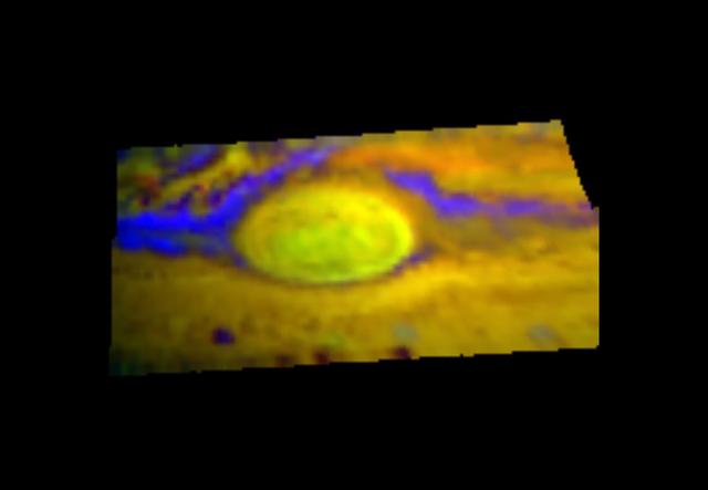
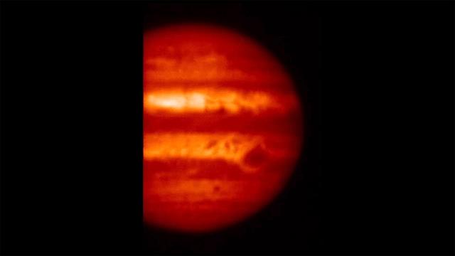
This infrared image, taken by NASA Galileo spacecraft in late June, 1996, of Jupiter Great Red Spot has different colors than what you normally see.
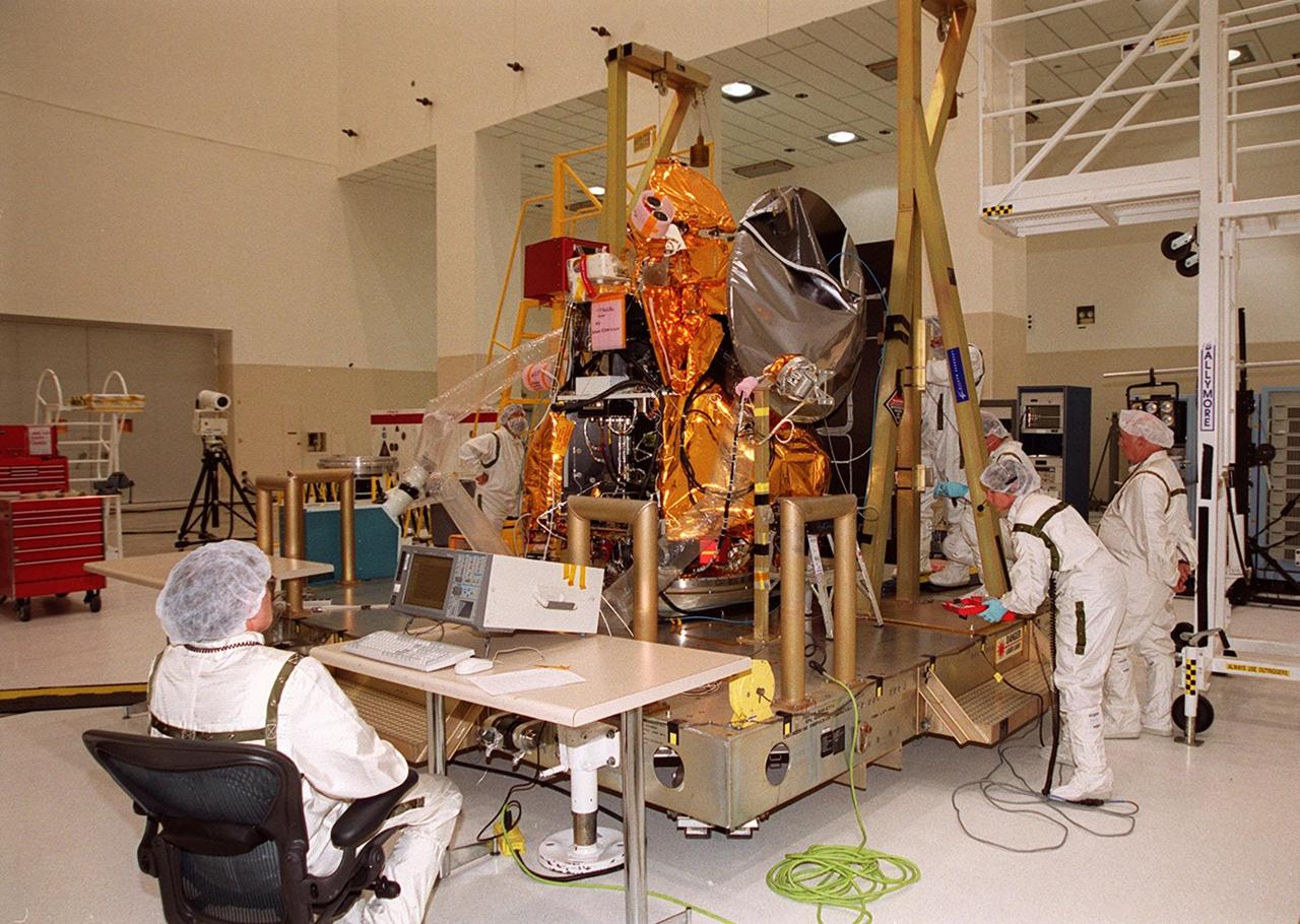
Workers in the Spacecraft Assembly and Encapsulation Facility (SAEF 2) get ready to conduct an illumination test on the 2001 Mars Odyssey Orbiter. Various components of the Odyssey Orbiter are undergoing testing. Scheduled for launch April 7, 2001, the orbiter contains three science instruments: THEMIS, the Gamma Ray Spectrometer (GRS), and the Mars Radiation Environment Experiment (MARIE). THEMIS will map the mineralogy and morphology of the Martian surface using a high-resolution camera and a thermal infrared imaging spectrometer. The GRS will achieve global mapping of the elemental composition of the surface and determine the abundance of hydrogen in the shallow subsurface. The MARIE will characterize aspects of the near-space radiation environment with regards to the radiation-related risk to human explorers
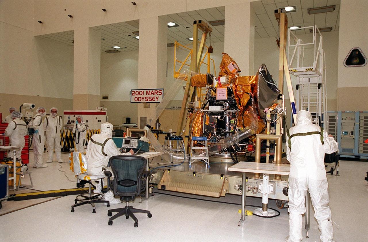
The 2001 Mars Odyssey Orbiter sits in the Spacecraft Assembly and Encapsulation Facility (SAEF 2) while components undergo testing. Workers in the foreground check instruments during testing of the UHF antenna. Scheduled for launch April 7, 2001, the orbiter contains three science instruments: THEMIS, the Gamma Ray Spectrometer (GRS), and the Mars Radiation Environment Experiment (MARIE). THEMIS will map the mineralogy and morphology of the Martian surface using a high-resolution camera and a thermal infrared imaging spectrometer. The GRS will achieve global mapping of the elemental composition of the surface and determine the abundance of hydrogen in the shallow subsurface. The MARIE will characterize aspects of the near-space radiation environment with regards to the radiation-related risk to human explorers

The first stage of a Boeing Delta rocket arrives on Launch Pad 17-A, Cape Canaveral Air Force Station. The rocket will carry the 2001 Mars Odyssey Orbiter, scheduled for launch April 7, 2001. Mars Odyssey contains three science instruments: THEMIS, the Gamma Ray Spectrometer (GRS), and the Mars Radiation Environment Experiment (MARIE). THEMIS will map the mineralogy and morphology of the Martian surface using a high-resolution camera and a thermal infrared imaging spectrometer. The GRS will achieve global mapping of the elemental composition of the surface and determine the abundance of hydrogen in the shallow subsurface. The MARIE will characterize aspects of the near-space radiation environment with regards to the radiation-related risk to human explorers

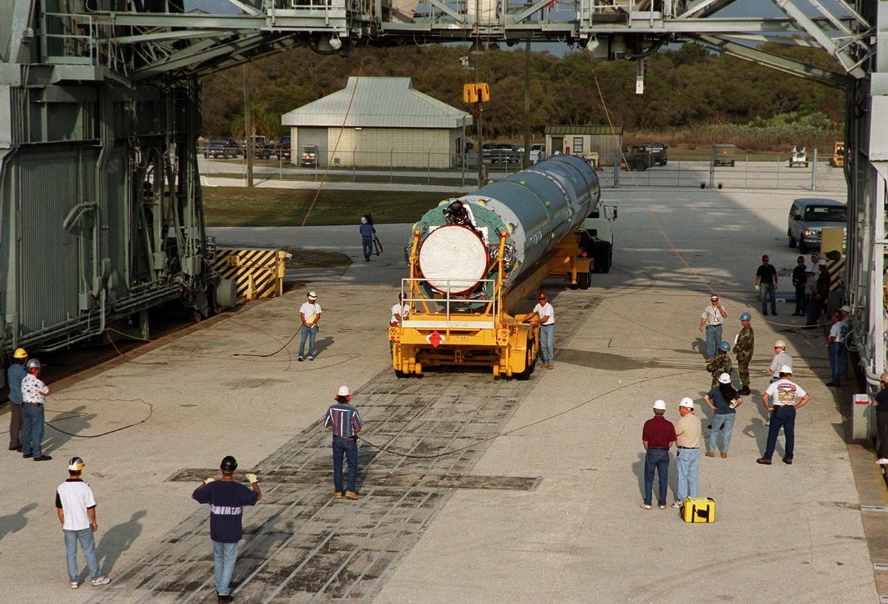
A crane lifts a solid rocket booster on Launch Pad 17-A, Cape Canaveral Air Force Station, where it will be mated with a Delta 7925 rocket for launch April 7, 2001. The rocket will carry the 2001 Mars Odyssey Orbiter, containing three science instruments: THEMIS, the Gamma Ray Spectrometer (GRS), and the Mars Radiation Environment Experiment (MARIE). THEMIS will map the mineralogy and morphology of the Martian surface using a high-resolution camera and a thermal infrared imaging spectrometer. The GRS will achieve global mapping of the elemental composition of the surface and determine the abundance of hydrogen in the shallow subsurface. The MARIE will characterize aspects of the near-space radiation environment with regards to the radiation-related risk to human explorers
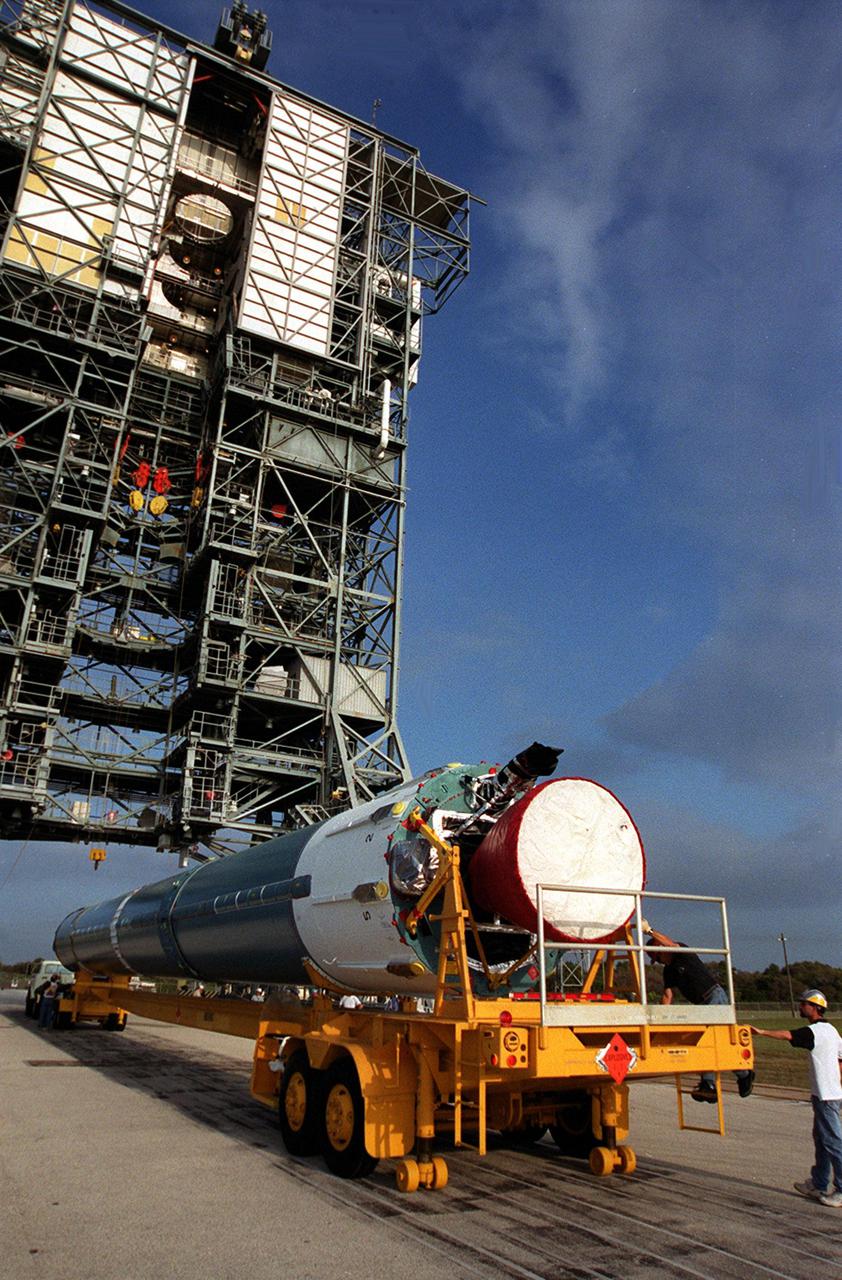
The first stage of a Boeing Delta rocket arrives on Launch Pad 17-A, Cape Canaveral Air Force Station. The rocket will carry the 2001 Mars Odyssey Orbiter, scheduled for launch April 7, 2001. Mars Odyssey contains three science instruments: THEMIS, the Gamma Ray Spectrometer (GRS), and the Mars Radiation Environment Experiment (MARIE). THEMIS will map the mineralogy and morphology of the Martian surface using a high-resolution camera and a thermal infrared imaging spectrometer. The GRS will achieve global mapping of the elemental composition of the surface and determine the abundance of hydrogen in the shallow subsurface. The MARIE will characterize aspects of the near-space radiation environment with regards to the radiation-related risk to human explorers
The first stage of a Boeing Delta rocket backs into position to be lifted for erection on Launch Pad 17-A, Cape Canaveral Air Force Station. The rocket will carry the 2001 Mars Odyssey Orbiter, scheduled for launch April 7, 2001. Mars Odyssey contains three science instruments: THEMIS, the Gamma Ray Spectrometer (GRS), and the Mars Radiation Environment Experiment (MARIE). THEMIS will map the mineralogy and morphology of the Martian surface using a high-resolution camera and a thermal infrared imaging spectrometer. The GRS will achieve global mapping of the elemental composition of the surface and determine the abundance of hydrogen in the shallow subsurface. The MARIE will characterize aspects of the near-space radiation environment with regards to the radiation-related risk to human explorers
Workers in the Spacecraft Assembly and Encapsulation Facility (SAEF 2) reattach the solar panel on the 2001 Mars Odyssey Orbiter in order to conduct illumination testing. Scheduled for launch April 7, 2001, the orbiter contains three science instruments: THEMIS, the Gamma Ray Spectrometer (GRS), and the Mars Radiation Environment Experiment (MARIE). THEMIS will map the mineralogy and morphology of the Martian surface using a high-resolution camera and a thermal infrared imaging spectrometer. The GRS will achieve global mapping of the elemental composition of the surface and determine the abundance of hydrogen in the shallow subsurface. The MARIE will characterize aspects of the near-space radiation environment with regards to the radiation-related risk to human explorers
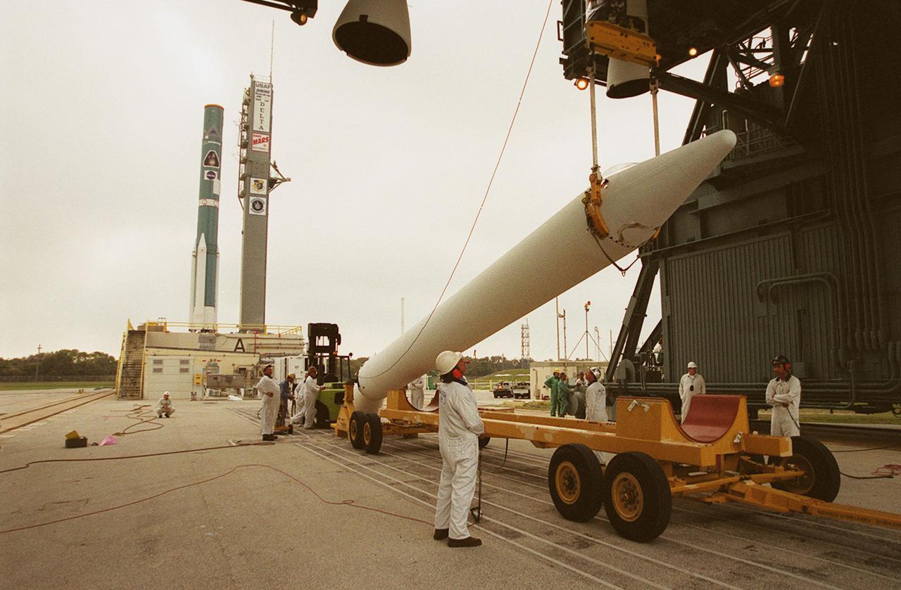
A crane lifts a solid rocket booster on Launch Pad 17-A, Cape Canaveral Air Force Station, where it will be mated with a Delta 7925 rocket for launch April 7, 2001. The rocket will carry the 2001 Mars Odyssey Orbiter, containing three science instruments: THEMIS, the Gamma Ray Spectrometer (GRS), and the Mars Radiation Environment Experiment (MARIE). THEMIS will map the mineralogy and morphology of the Martian surface using a high-resolution camera and a thermal infrared imaging spectrometer. The GRS will achieve global mapping of the elemental composition of the surface and determine the abundance of hydrogen in the shallow subsurface. The MARIE will characterize aspects of the near-space radiation environment with regards to the radiation-related risk to human explorers

On Launch Pad 17-A, Cape Canaveral Air Force Station, workers maneuver the first stage of a Boeing Delta rocket into a vertical position . The rocket will carry the 2001 Mars Odyssey Orbiter, scheduled for launch April 7, 2001. Mars Odyssey contains three science instruments: THEMIS, the Gamma Ray Spectrometer (GRS), and the Mars Radiation Environment Experiment (MARIE). THEMIS will map the mineralogy and morphology of the Martian surface using a high-resolution camera and a thermal infrared imaging spectrometer. The GRS will achieve global mapping of the elemental composition of the surface and determine the abundance of hydrogen in the shallow subsurface. The MARIE will characterize aspects of the near-space radiation environment with regards to the radiation-related risk to human explorers

A Delta 7925 rocket on Launch Pad 17-A, Cape Canaveral Air Force Station, is being erected for launch April 7, 2001. The rocket will carry the 2001 Mars Odyssey Orbiter, containing three science instruments: THEMIS, the Gamma Ray Spectrometer (GRS), and the Mars Radiation Environment Experiment (MARIE). THEMIS will map the mineralogy and morphology of the Martian surface using a high-resolution camera and a thermal infrared imaging spectrometer. The GRS will achieve global mapping of the elemental composition of the surface and determine the abundance of hydrogen in the shallow subsurface. The MARIE will characterize aspects of the near-space radiation environment with regards to the radiation-related risk to human explorers
Arrays of lights (left) in the Spacecraft Assembly and Encapsulation Facility (SAEF 2) are used for illumination testing on the solar array panels at right. The panels are part of on the 2001 Mars Odyssey Orbiter. Scheduled for launch April 7, 2001, the orbiter contains three science instruments: THEMIS, the Gamma Ray Spectrometer (GRS), and the Mars Radiation Environment Experiment (MARIE). THEMIS will map the mineralogy and morphology of the Martian surface using a high-resolution camera and a thermal infrared imaging spectrometer. The GRS will achieve global mapping of the elemental composition of the surface and determine the abundance of hydrogen in the shallow subsurface. The MARIE will characterize aspects of the near-space radiation environment with regards to the radiation-related risk to human explorers
In the Spacecraft Assembly and Encapsulation Facility (SAEF 2), workers get ready to open the panels of the solar array on the 2001 Mars Odyssey Orbiter in order to conduct illumination testing. Scheduled for launch April 7, 2001, the orbiter contains three science instruments: THEMIS, the Gamma Ray Spectrometer (GRS), and the Mars Radiation Environment Experiment (MARIE). THEMIS will map the mineralogy and morphology of the Martian surface using a high-resolution camera and a thermal infrared imaging spectrometer. The GRS will achieve global mapping of the elemental composition of the surface and determine the abundance of hydrogen in the shallow subsurface. The MARIE will characterize aspects of the near-space radiation environment with regards to the radiation-related risk to human explorers
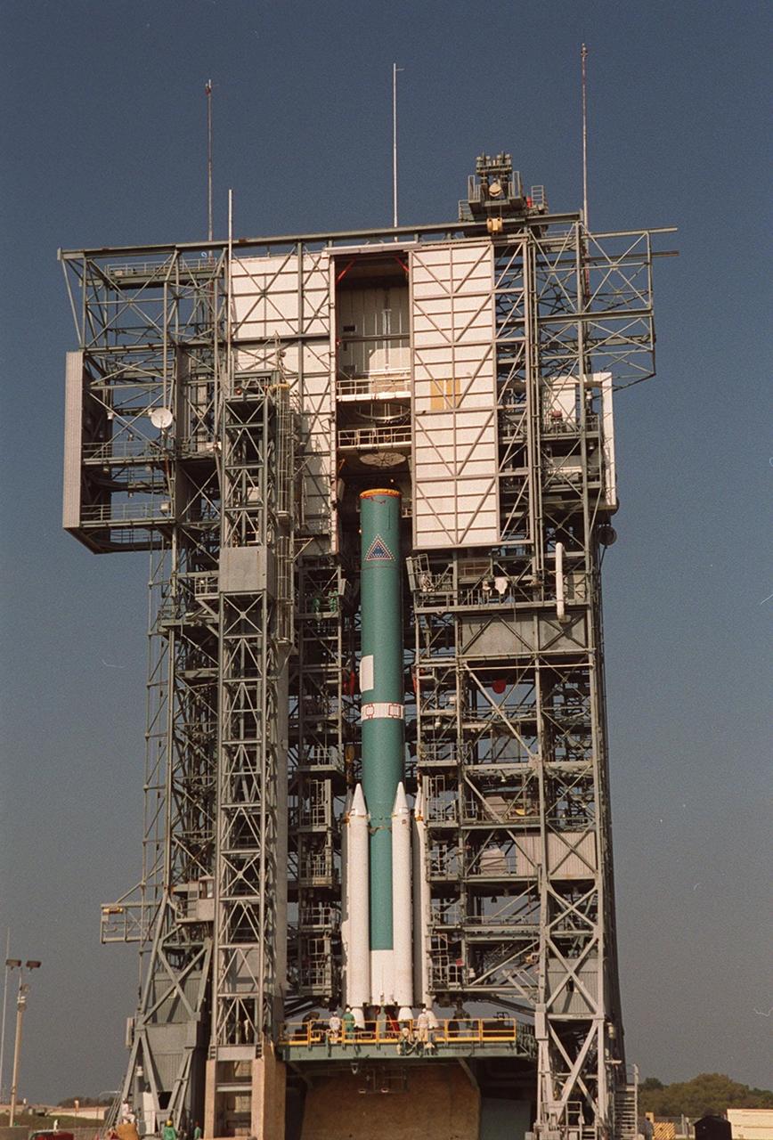
The moveable gantry closes in on a Delta 7925 rocket, bringing an additional three solid rocket boosters for mating to the rocket. Scheduled to launch April 7, 2001, the rocket will carry the 2001 Mars Odyssey Orbiter, containing three science instruments: THEMIS, the Gamma Ray Spectrometer (GRS), and the Mars Radiation Environment Experiment (MARIE). THEMIS will map the mineralogy and morphology of the Martian surface using a high-resolution camera and a thermal infrared imaging spectrometer. The GRS will achieve global mapping of the elemental composition of the surface and determine the abundance of hydrogen in the shallow subsurface. The MARIE will characterize aspects of the near-space radiation environment with regards to the radiation-related risk to human explorers

The first stage of a Boeing Delta rocket is lifted vertically up the gantry on Launch Pad 17-A, Cape Canaveral Air Force Station. The rocket will carry the 2001 Mars Odyssey Orbiter, scheduled for launch April 7, 2001. Mars Odyssey contains three science instruments: THEMIS, the Gamma Ray Spectrometer (GRS), and the Mars Radiation Environment Experiment (MARIE). THEMIS will map the mineralogy and morphology of the Martian surface using a high-resolution camera and a thermal infrared imaging spectrometer. The GRS will achieve global mapping of the elemental composition of the surface and determine the abundance of hydrogen in the shallow subsurface. The MARIE will characterize aspects of the near-space radiation environment with regards to the radiation-related risk to human explorers