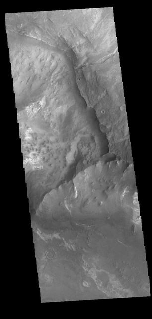
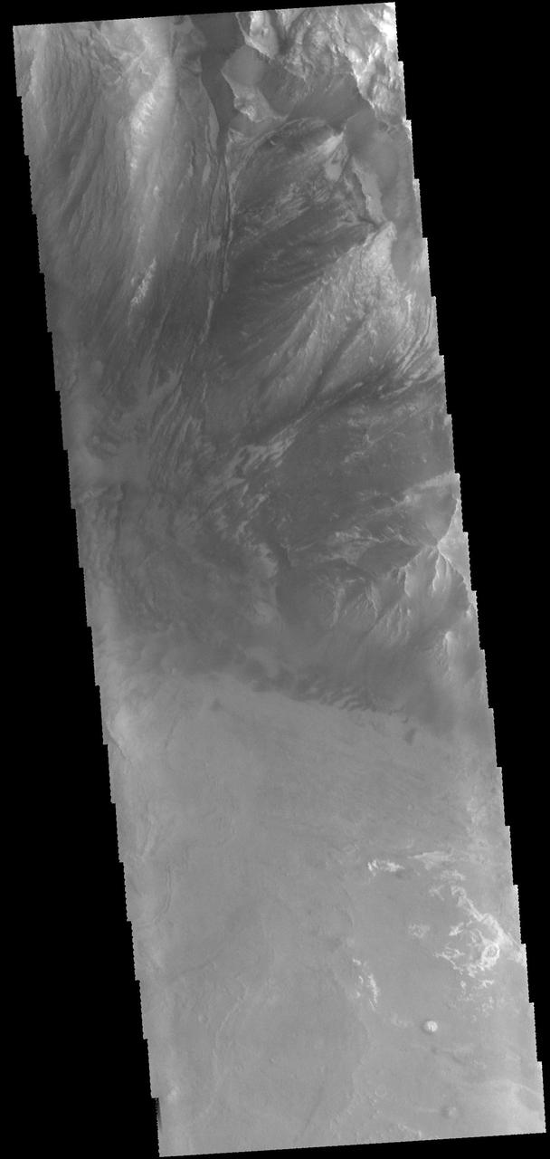
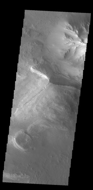
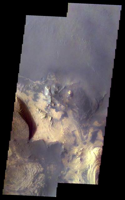
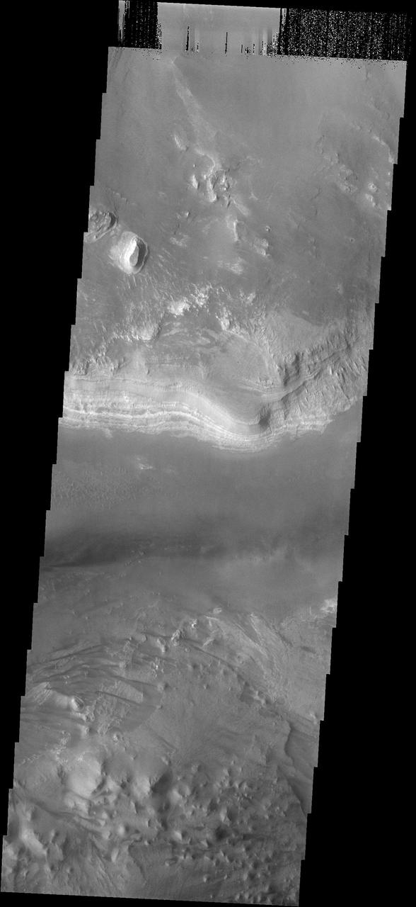
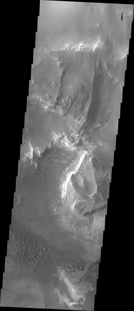
Today's VIS image shows part of the canyon wall of Melas Chasma. Orbit Number: 65682 Latitude: -9.38343 Longitude: 289.417 Instrument: VIS Captured: 2016-10-04 02:52 http://photojournal.jpl.nasa.gov/catalog/PIA21181
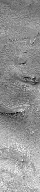
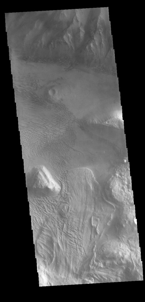
Melas Chasma
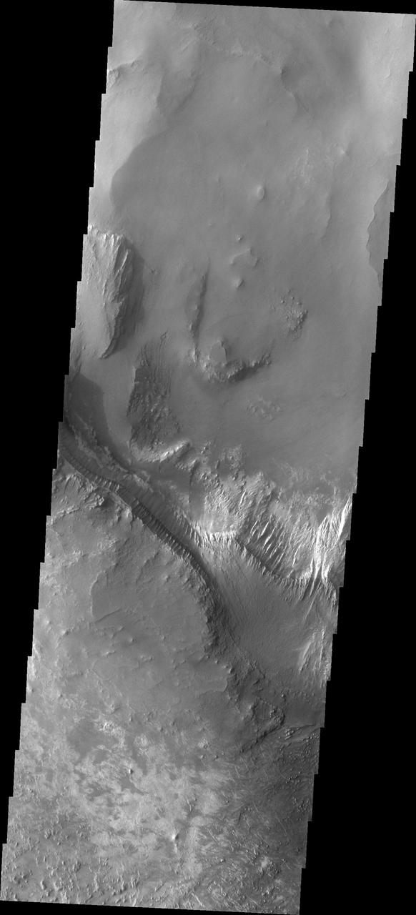
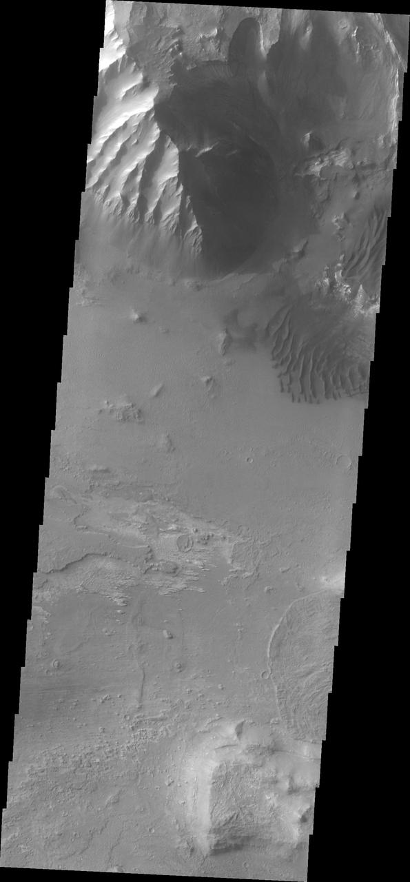
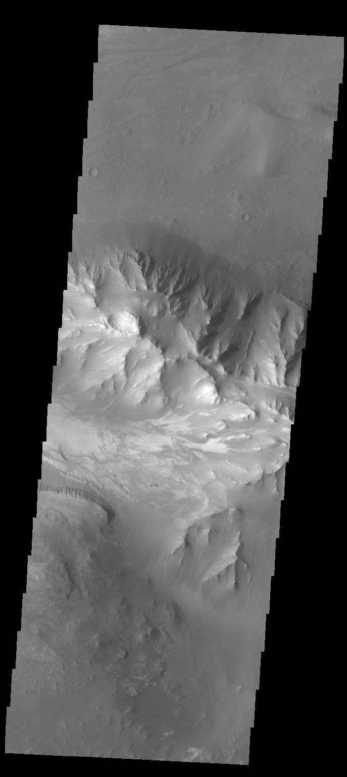
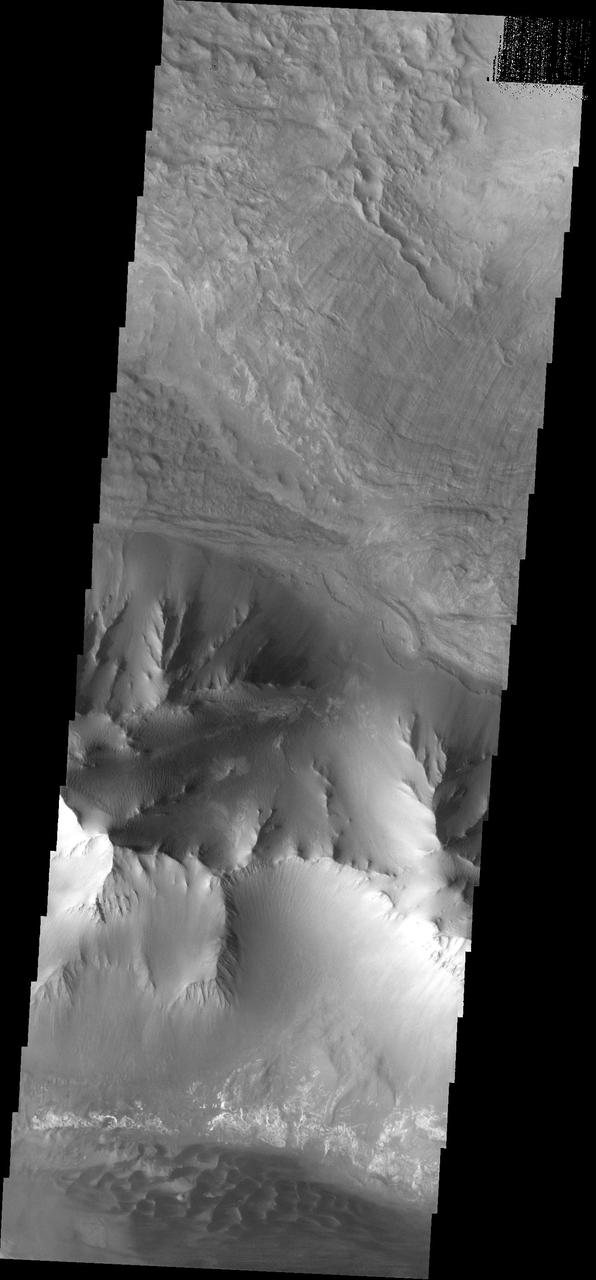
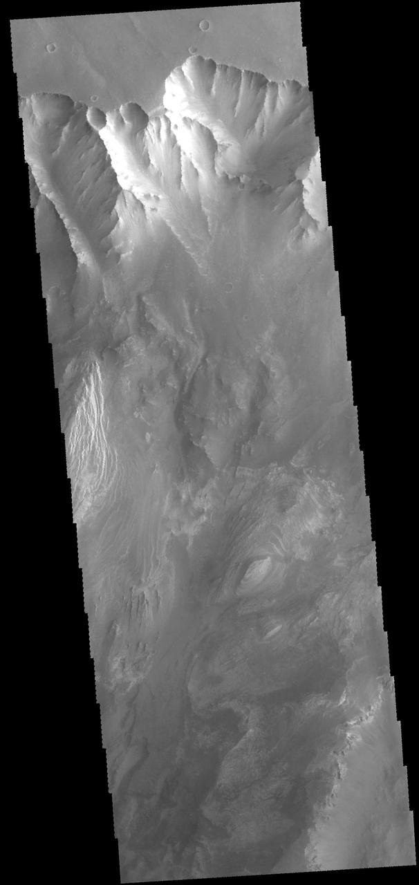
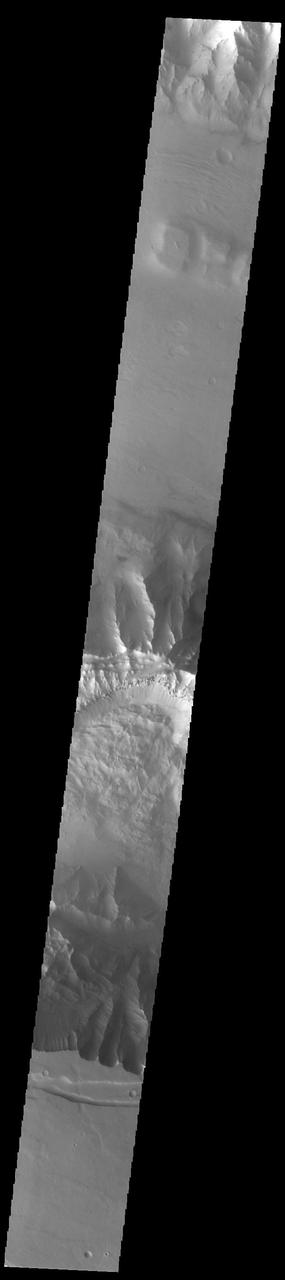
Melas Chasma
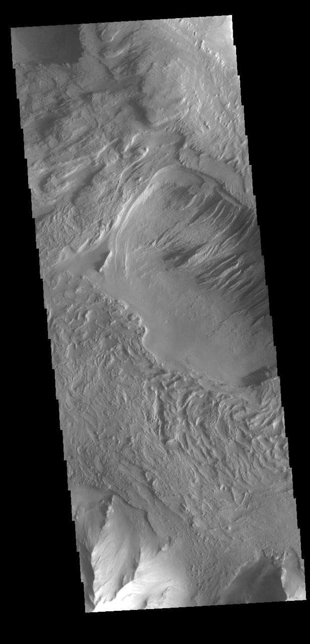
Melas Chasma
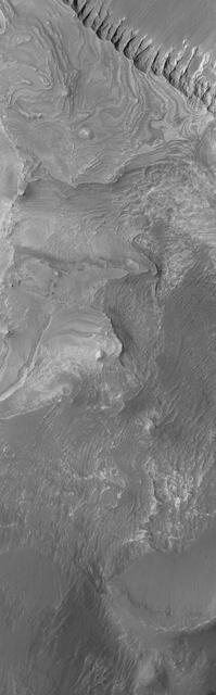
Melas Chasma
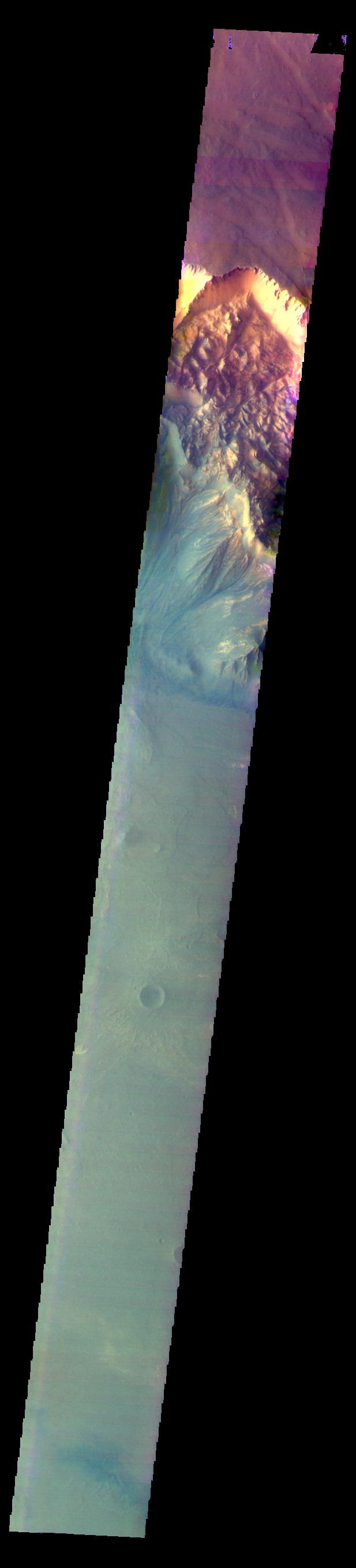
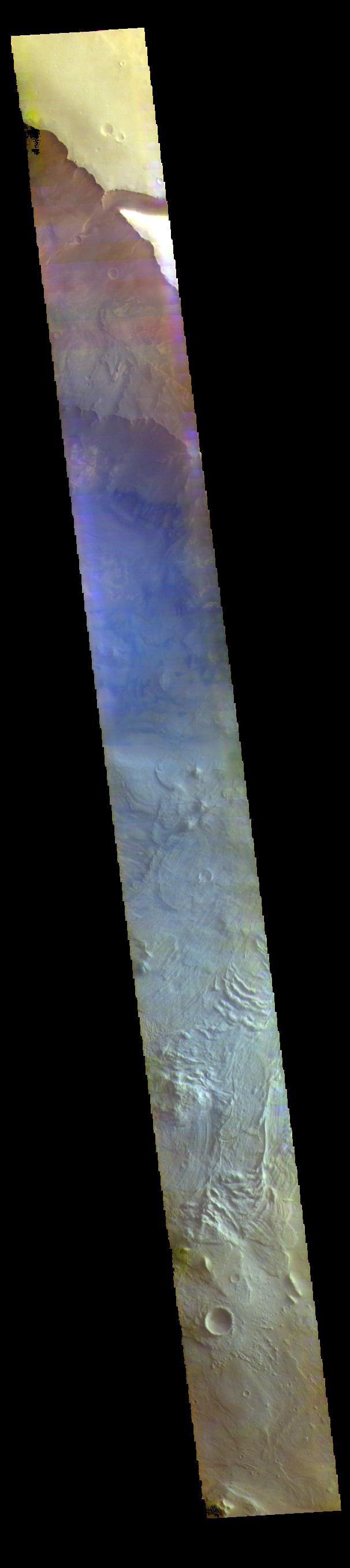
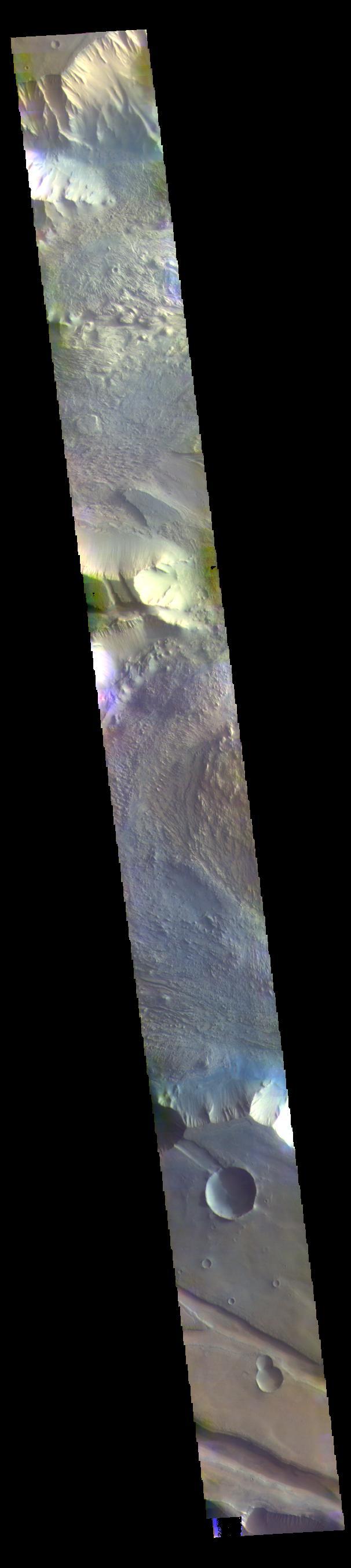
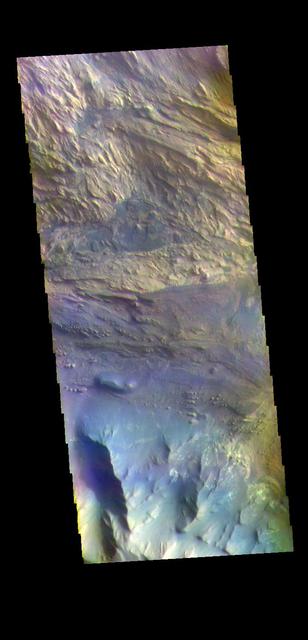
The THEMIS VIS camera contains 5 filters. The data from different filters can be combined in multiple ways to create a false color image. These false color images may reveal subtle variations of the surface not easily identified in a single band image. Today's false color image shows part of Melas Chasma. Orbit Number: 59750 Latitude: -10.5452 Longitude: 290.307 Instrument: VIS Captured: 2015-06-03 12:33 https://photojournal.jpl.nasa.gov/catalog/PIA21705
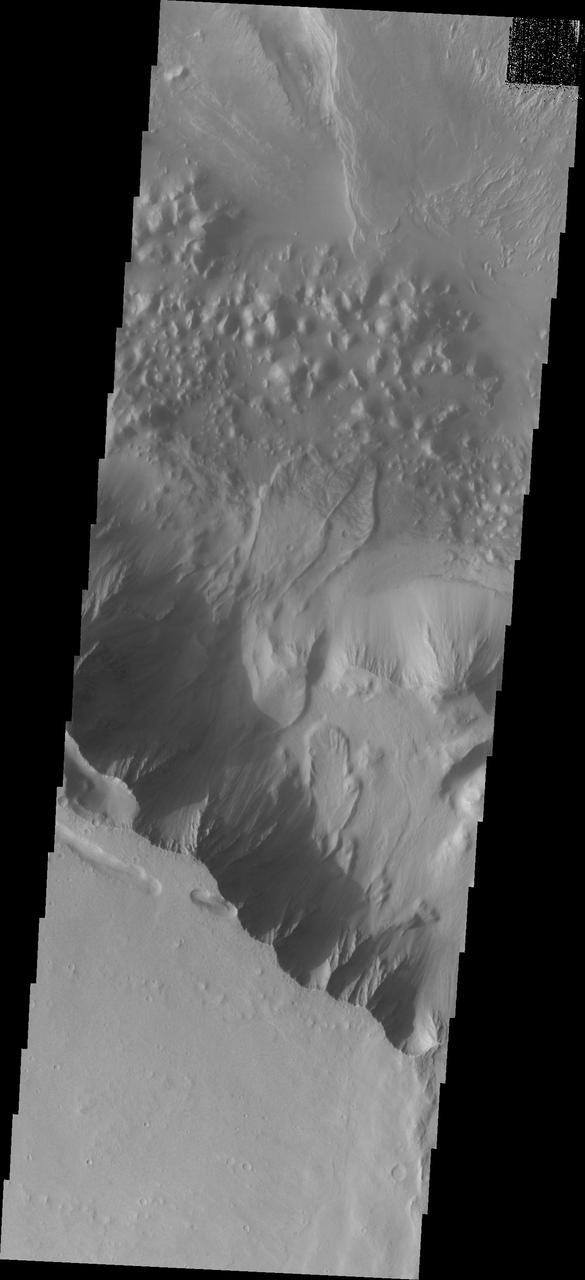
Melas Chasma in IR Color
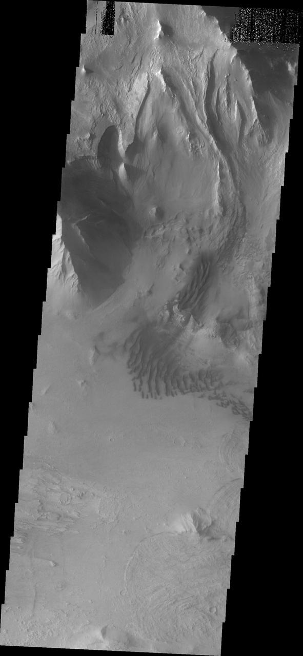
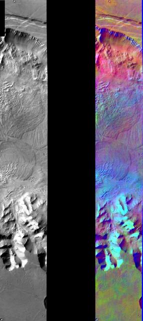
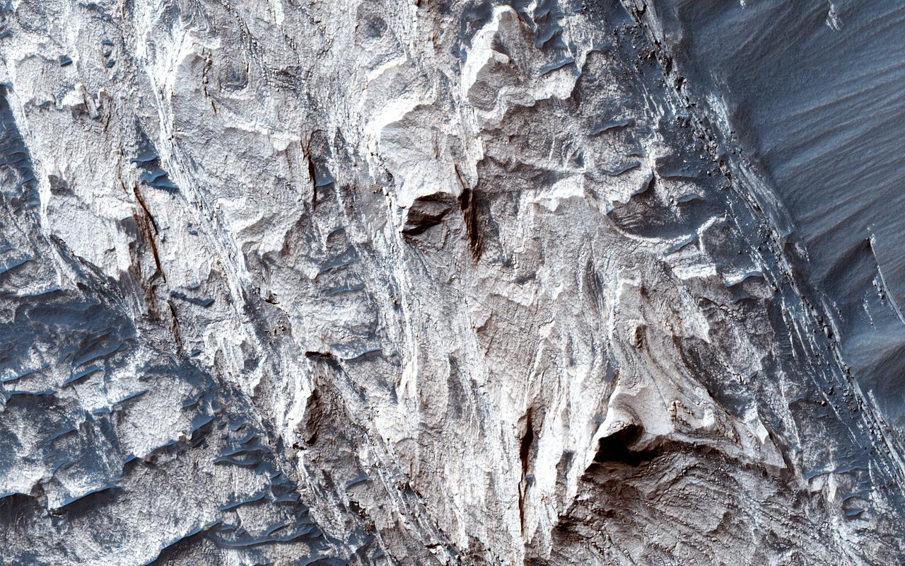
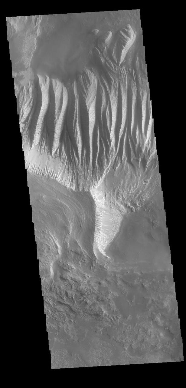
Buttes in Melas Chasma
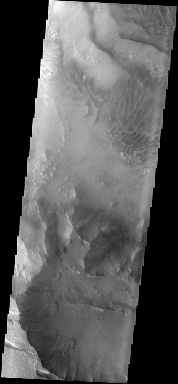
Layers in Melas Chasma

Melas Chasma Floor
Layers in Melas Chasma

Melas Chasma Floor
This image captured by NASA 2001 Mars Odyssey spacecraft shows the part of the floor of Melas Chasma. Melas Chasma in the central chasma of Valles Marineris.
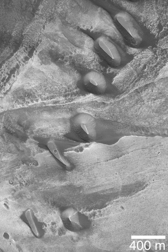
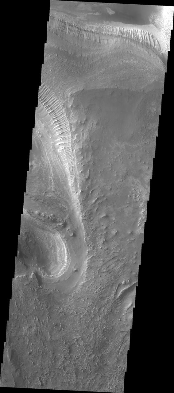
Layers and a Dust Devil in Melas Chasma
Layers and Dark Debris in Melas Chasma
Ridged Terrain on the Floor Melas Chasma
Light-Toned Material in Melas Chasma
Proposed MSL Site in Melas Chasma
Melas Chasma is the central portion of Valles Marineris. This image taken by NASA 2001 Mars Odyssey shows a small portion of the floor of Melas Chasma, including layered deposits and wind eroded and deposited materials.
This image from NASA Mars Odyssey shows the northern sidewall of Melas Chasma.
This image shows a small portion of the floor deposits within Melas Chasma.
A surprise landslump in Melas Chasma was observed by NASA Mars Reconnaissance Orbiter.

This image shows part of the floor of Melas Chasma. Layered materials and sand are common in this section of canyon
This image captured by NASA 2001 Mars Odyssey spacecraft shows part of Melas Chasma.
This image captured by NASA 2001 Mars Odyssey spacecraft shows dunes on the floor of Melas Chasma.
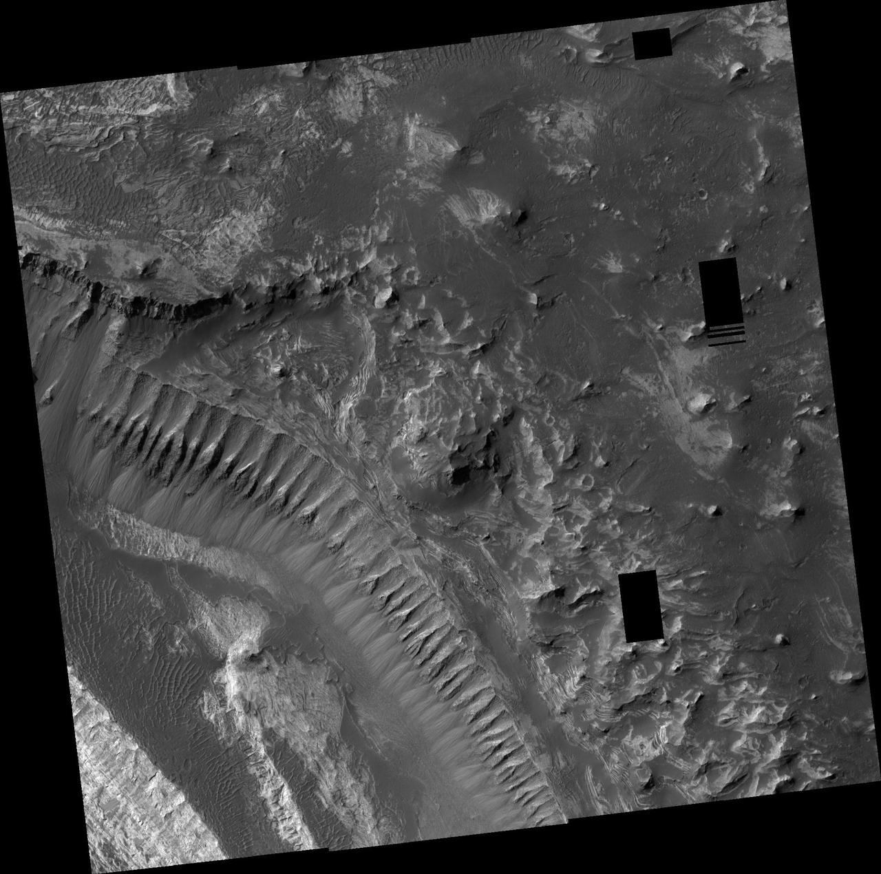
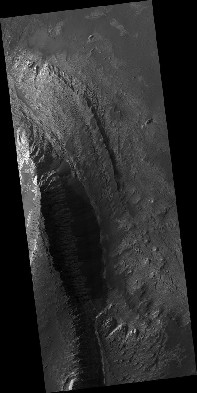
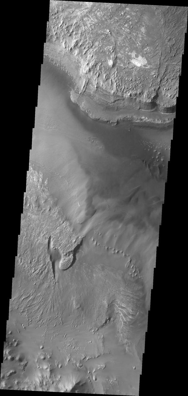
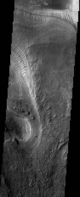
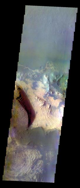
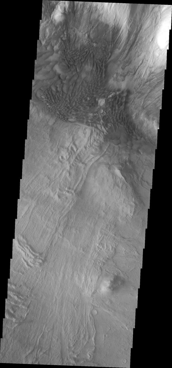
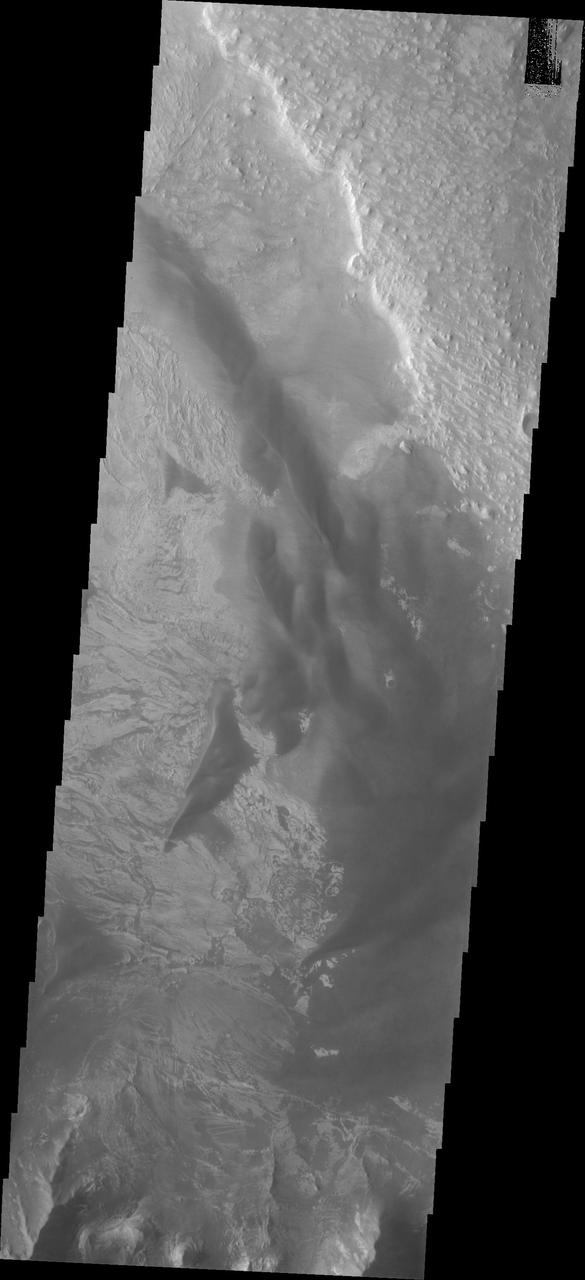
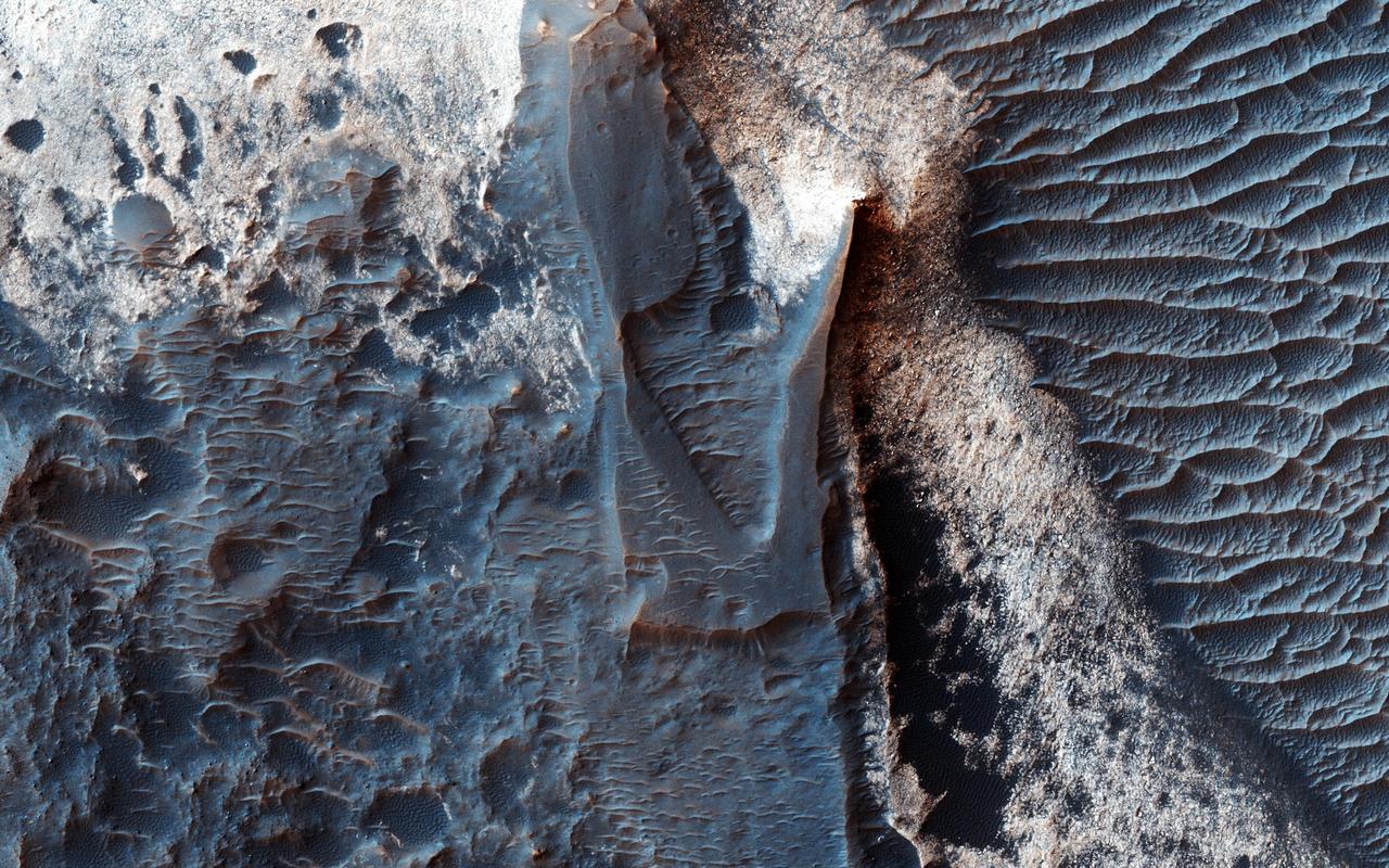
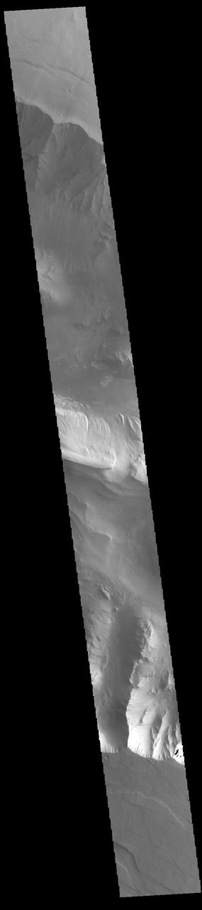
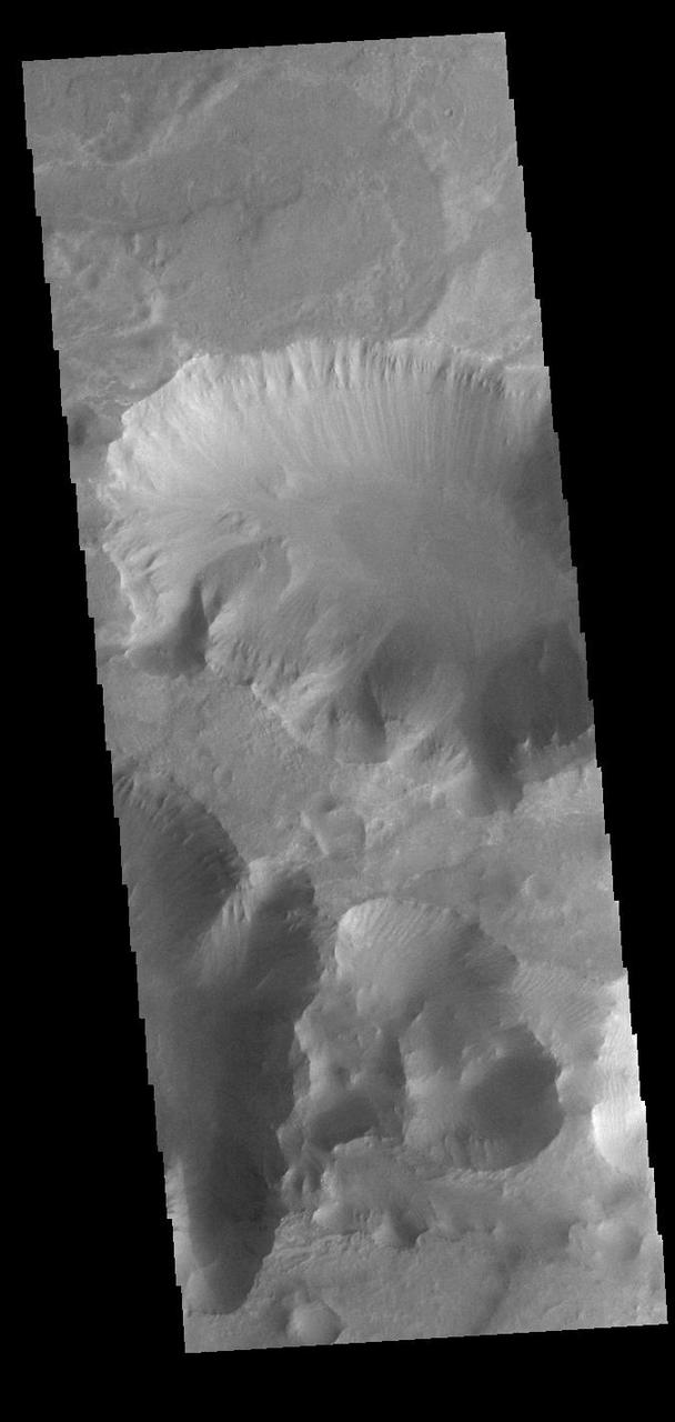
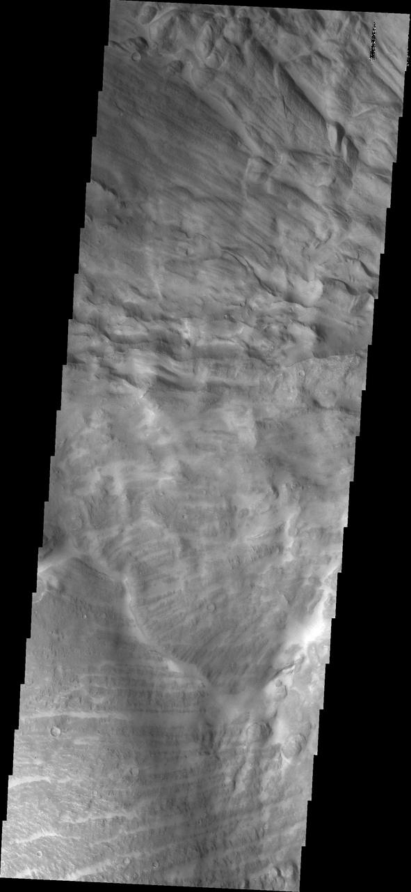
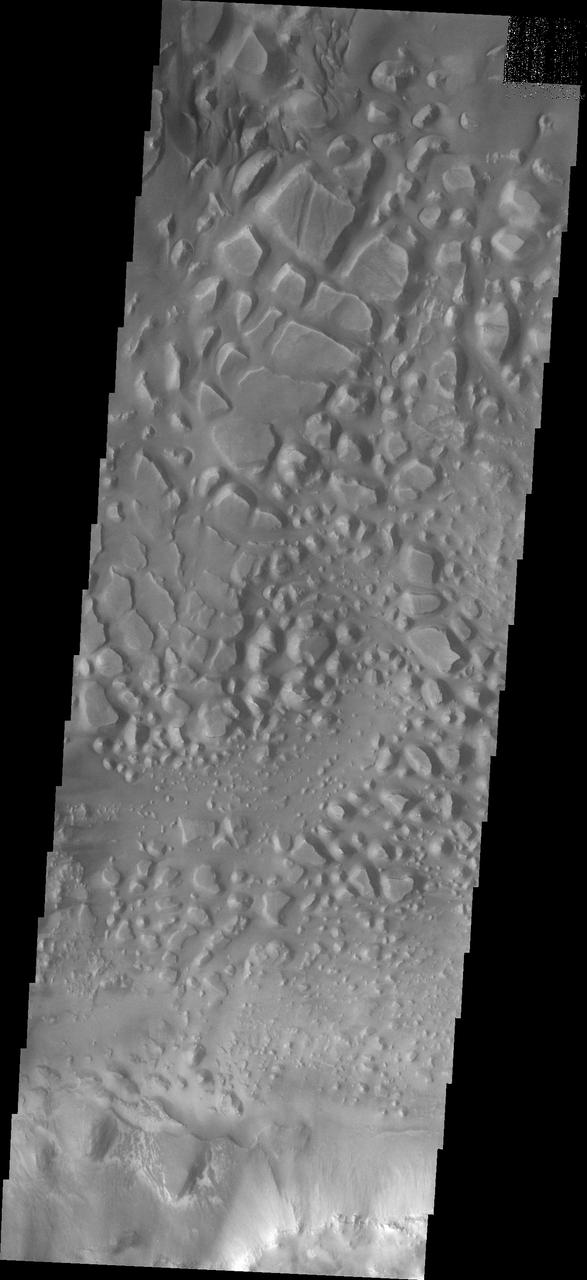
This VIS image is located in Melas Chasma. The linear and arcuate features at the top of the image are on the surface of a large landslide. This region of Melas Chasma is covered by several very large landslide deposits. Melas Chasma is part of the largest canyon system on Mars, Valles Marineris. At only 563 km long (349 miles) Melas is not the longest canyon, but it is the widest. Located in the center of Valles Marineris, it has depths up to 9,000 meters (30,000 feet) from the surrounding plains. In addition to landslide deposits, there are layered materials and sand dunes. There is evidence of both water and wind action as modes of formation for many of the interior deposits. Orbit Number: 80264 Latitude: -11.2236 Longitude: 289.776 Instrument: VIS Captured: 2020-01-18 06:05 https://photojournal.jpl.nasa.gov/catalog/PIA23817
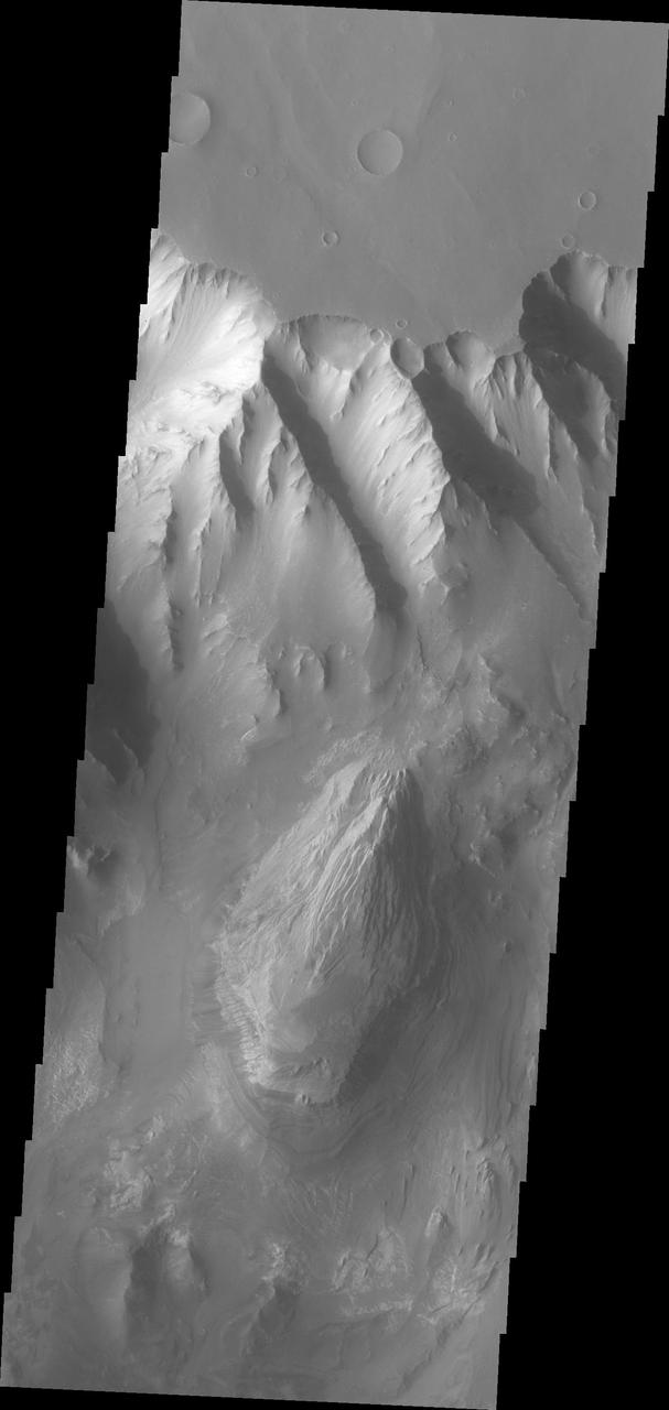
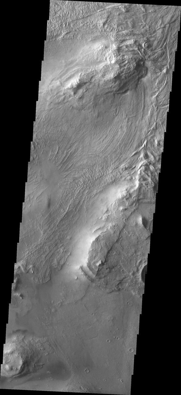
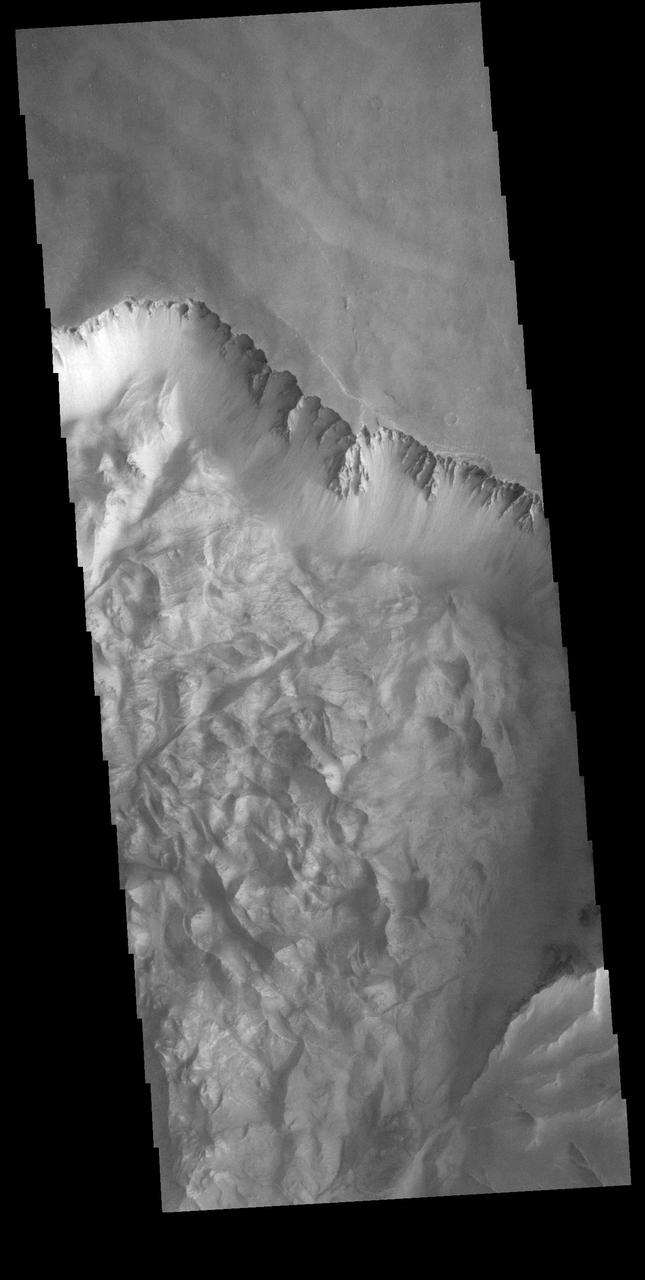
This VIS image shows part of the southern cliffside of Melas Chasma. Melas Chasma is part of the largest canyon system on Mars, Valles Marineris. At only 563 km long (349 miles) it is not the longest canyon, but it is the widest. Located in the center of Valles Marineris, it has depths up to 9 km below the surrounding plains, and is the location of many large landslide deposits, as will as layered materials and sand dunes. There is evidence of both water and wind action as modes of formation for many of the interior deposits. Orbit Number: 81537 Latitude: -11.3482 Longitude: 284.901 Instrument: VIS Captured: 2020-05-02 01:42 https://photojournal.jpl.nasa.gov/catalog/PIA23992
This image captured by NASA 2001 Mars Odyssey spacecraft shows part of the floor of Melas Chasma, which is part of the much larger Valles Marineris.
The landslide in the center of this image from NASA 2001 Mars Odyssey spacecraft occurred in the Melas Chasma region of Valles Marineris.
This image from NASA Mars Odyssey shows a small portion of two landslide deposits within Melas Chasma.
This image captured NASA Mars Odyssey shows part of a landslide deposit in Melas Chasma.
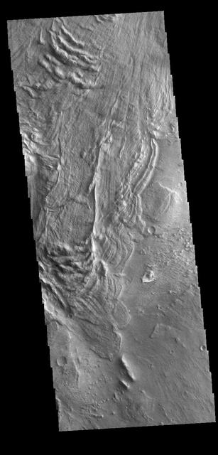
This VIS image is located in Melas Chasma. The linear and arcuate features are on the surface of a large landslide. This region of Melas Chasma is covered by several very large landslide deposits. Melas Chasma is part of the largest canyon system on Mars, Valles Marineris. At only 563 km long (349 miles) Melas is not the longest canyon, but it is the widest. Located in the center of Valles Marineris, it has depths up to 9,000 meters (30,000 feet) from the surrounding plains. In addition to landslide deposits, there are layered materials and sand dunes. There is evidence of both water and wind action as modes of formation for many of the interior deposits. Orbit Number: 78255 Latitude: -10.9711 Longitude: 290.017 Instrument: VIS Captured: 2019-08-05 19:51 https://photojournal.jpl.nasa.gov/catalog/PIA23459
Melas Chasma is part of the Valles Marineris canyon system, the largest canyon in the Solar System. This image was taken by NASA Mars Reconnaissance Orbiter.
This VIS image shows part of the southwestern cliffside of Melas Chasma. Melas Chasma is part of the largest canyon system on Mars, Valles Marineris. At only 563 km long (349 miles) it is not the longest canyon, but it is the widest. Located in the center of Valles Marineris, it has depths up to 9 km below the surrounding plains, and is the location of many large landslide deposits, as will as layered materials and sand dunes. There is evidence of both water and wind action as modes of formation for many of the interior deposits. Orbit Number: 90921 Latitude: -11.3343 Longitude: 284.714 Instrument: VIS Captured: 2022-06-13 17:44 https://photojournal.jpl.nasa.gov/catalog/PIA25519
This image is a mosaic of day and night infrared images of Melas Chasma taken by NASA Mars Odyssey spacecraft. The daytime temperature images are shown in black and white, superimposed on the Martian topography.
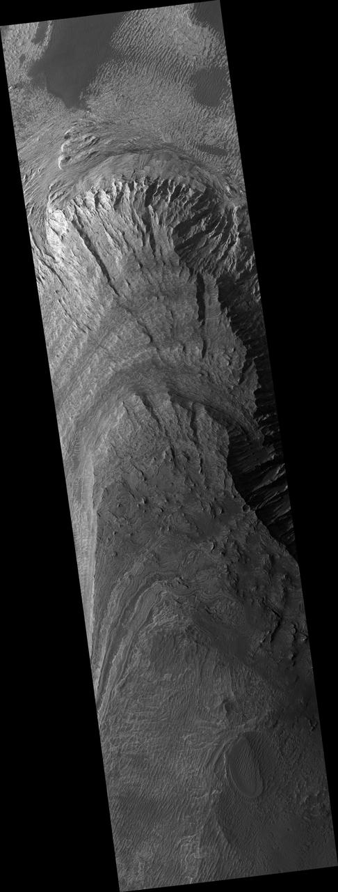
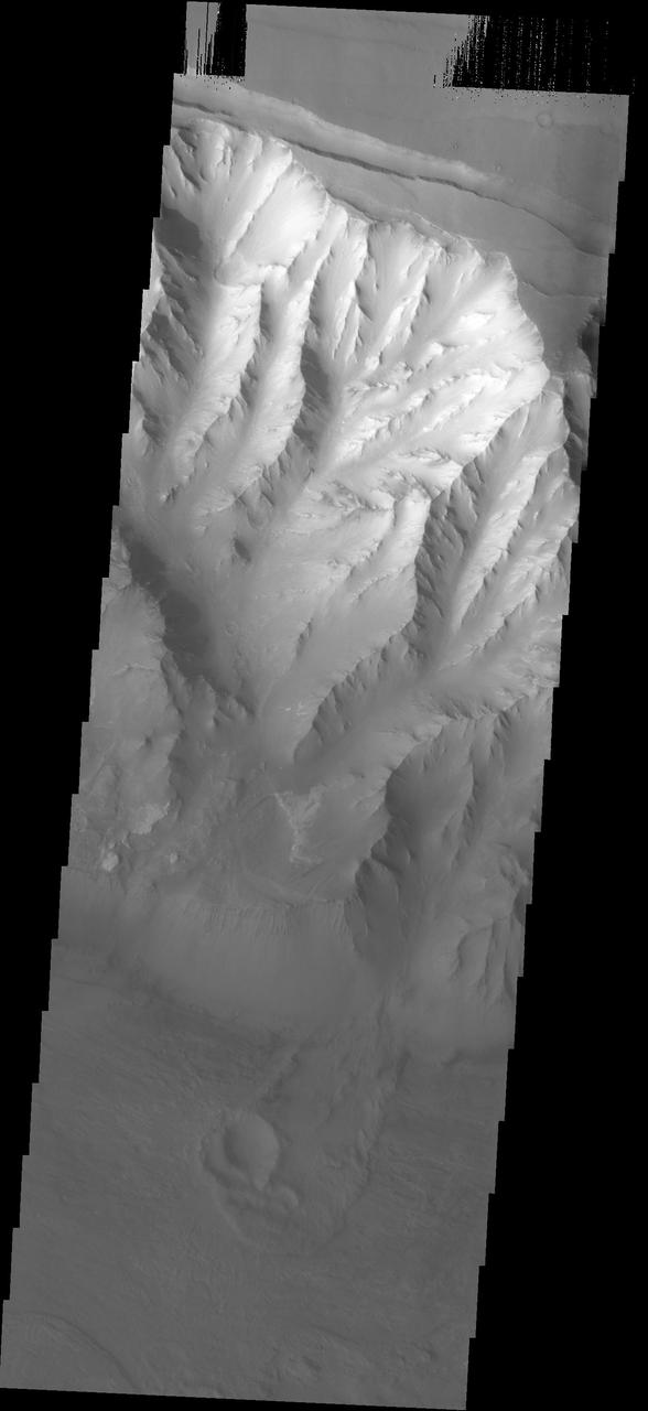
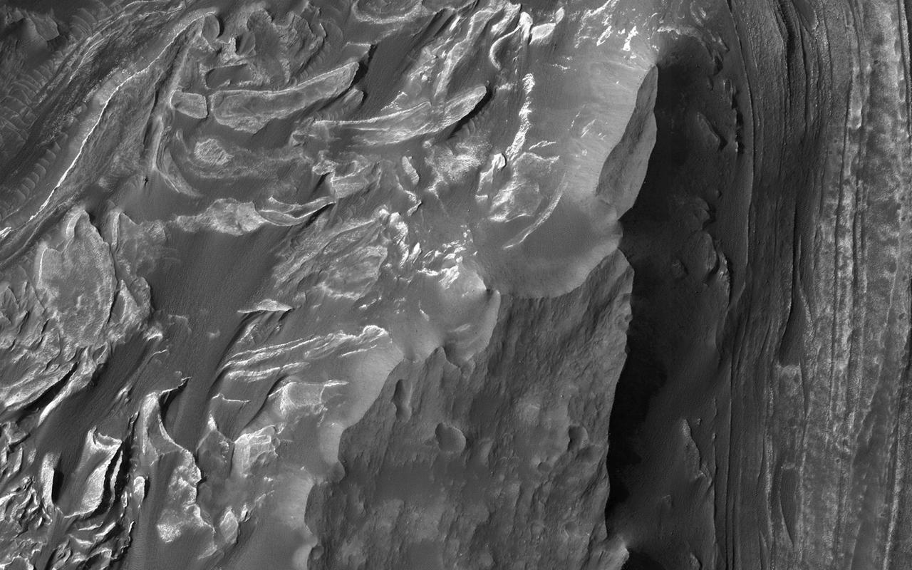
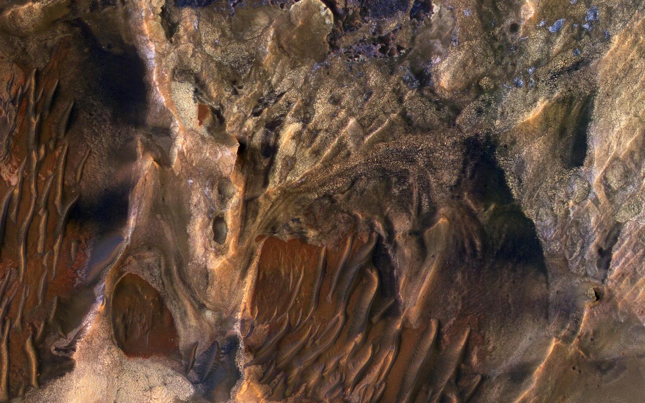
Erosion of the interior layered deposits of Melas Chasma, part of the huge Valles Marineris canyon system, has produced cliffs with examples of spur and gulley morphology and exposures of finely layered sediments, as seen in this NASA Mars Odyssey image.
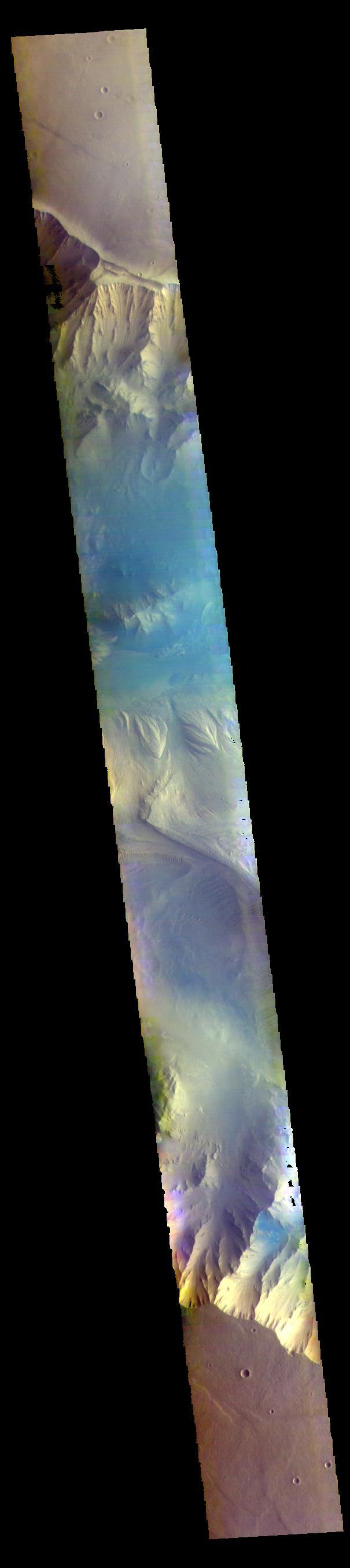
This false color image is located within Melas Chasma. The lobate forms at the bottom of the image are the remnants of landslides that crashed from the top of the cliff sides to the bottom of the chasma, a distance of 9km (5.5 miles). This distance is equivalent to the height of Mount Everest - the tallest land based mountain in the world. The THEMIS VIS camera contains 5 filters. The data from different filters can be combined in multiple ways to create a false color image. These false color images may reveal subtle variations of the surface not easily identified in a single band image. Orbit Number: 62002 Latitude: -10.1885 Longitude: 289.797 Instrument: VIS Captured: 2015-12-06 00:12 https://photojournal.jpl.nasa.gov/catalog/PIA23093
Melas Chasma is the widest segment of the Valles Marineris canyon, and is an area where NASA Mars Reconnaissance Orbiter has detected the presence of sulfates.
The THEMIS VIS camera contains 5 filters. The data from different filters can be combined in multiple ways to create a false color image. This false color image captured by NASA 2001 Mars Odyssey spacecraft shows part of Melas Chasma.
![In this image from NASA's Mars Reconnaissance Orbiter, a group of steeply inclined light-toned layers is bounded above and below by unconformities (sudden or irregular changes from one deposit to another) that indicate a "break" where erosion of pre-existing layers was taking place at a higher rate than deposition of new materials. The layered deposits in Melas Basin may have been deposited during the growth of a delta complex. This depositional sequence likely represents a period where materials were being deposited on the floor of a lake or running river. The map is projected here at a scale of 25 centimeters (9.8 inches) per pixel. [The original image scale is 28.9 centimeters (11.4 inches) per pixel (with 1 x 1 binning); objects on the order of 87 centimeters (34.2 inches) across are resolved.] North is up. https://photojournal.jpl.nasa.gov/catalog/PIA21580](https://images-assets.nasa.gov/image/PIA21580/PIA21580~medium.jpg)
In this image from NASA's Mars Reconnaissance Orbiter, a group of steeply inclined light-toned layers is bounded above and below by unconformities (sudden or irregular changes from one deposit to another) that indicate a "break" where erosion of pre-existing layers was taking place at a higher rate than deposition of new materials. The layered deposits in Melas Basin may have been deposited during the growth of a delta complex. This depositional sequence likely represents a period where materials were being deposited on the floor of a lake or running river. The map is projected here at a scale of 25 centimeters (9.8 inches) per pixel. [The original image scale is 28.9 centimeters (11.4 inches) per pixel (with 1 x 1 binning); objects on the order of 87 centimeters (34.2 inches) across are resolved.] North is up. https://photojournal.jpl.nasa.gov/catalog/PIA21580
Melas Chasma is the widest segment of Valles Marineris, the largest canyon in the Solar System as seen by Mars Reconnaissance Orbiter spacecraft. In this region, hydrated sulfate salts have been detected.
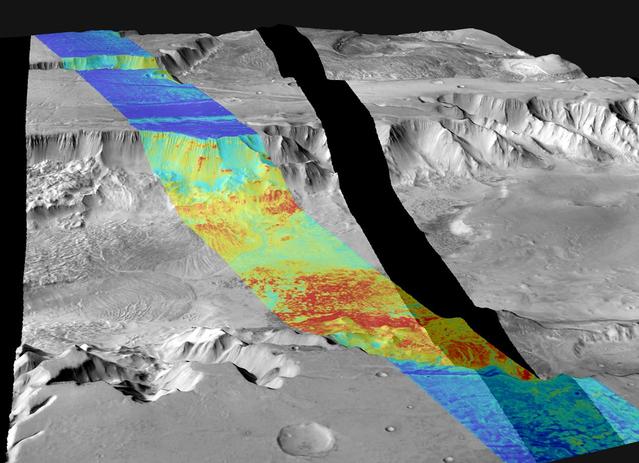
This image is a mosaic of day and night infrared images of Melas Chasma taken by NASA Mars Odyssey spacecraft. The daytime temperatures range from approximately -35 degrees Celsius -31 degrees Fahrenheit to -5 degrees Celsius 23 degrees Fahrenheit.
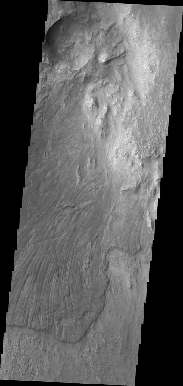
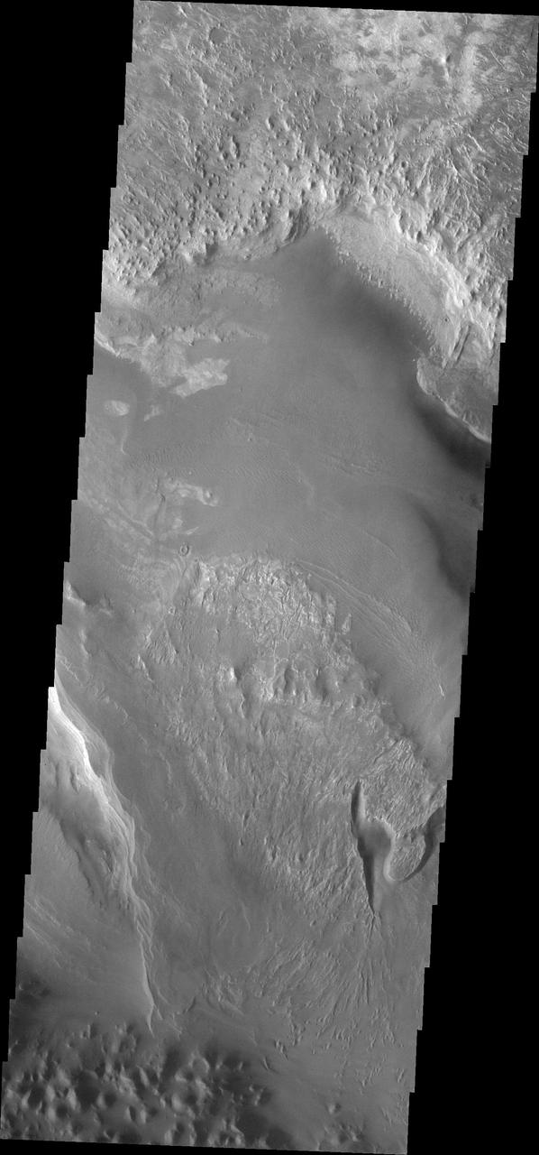
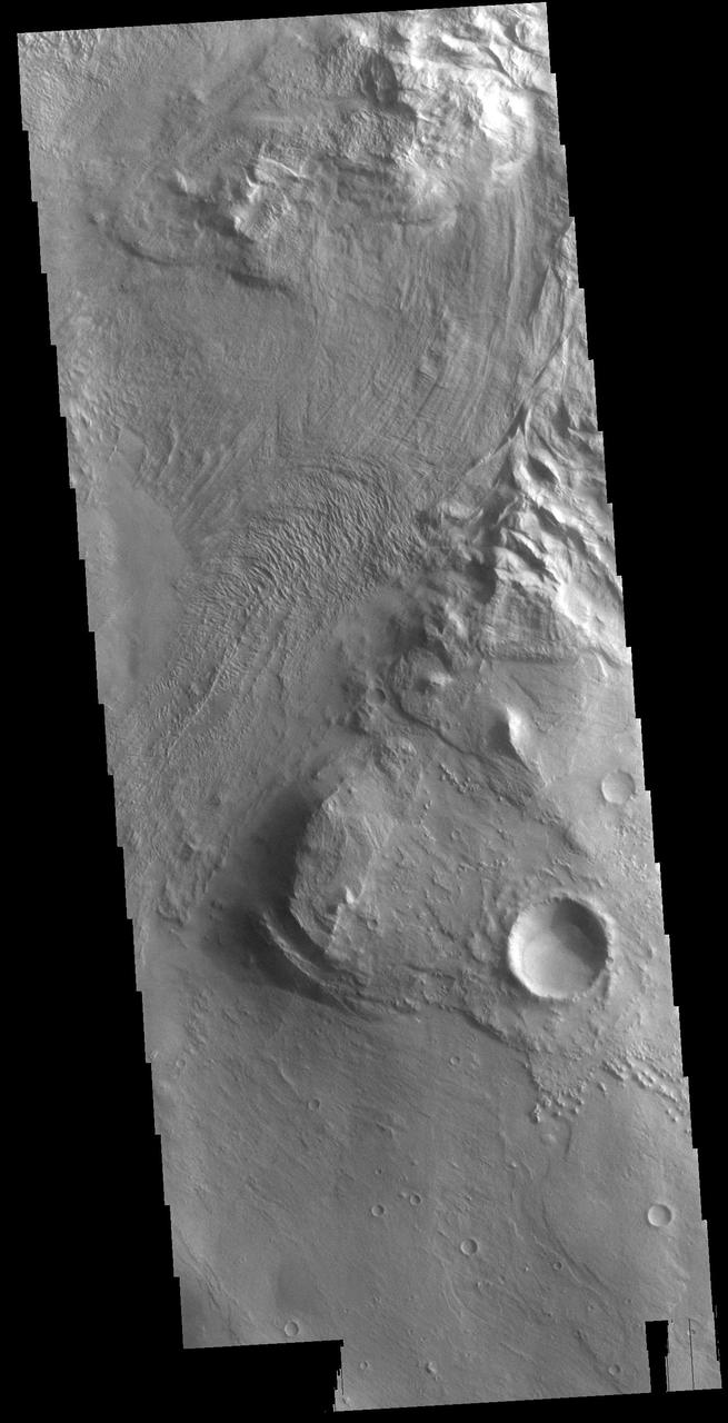
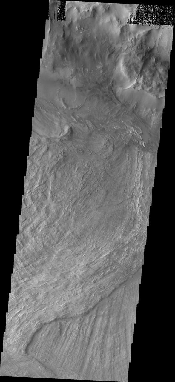
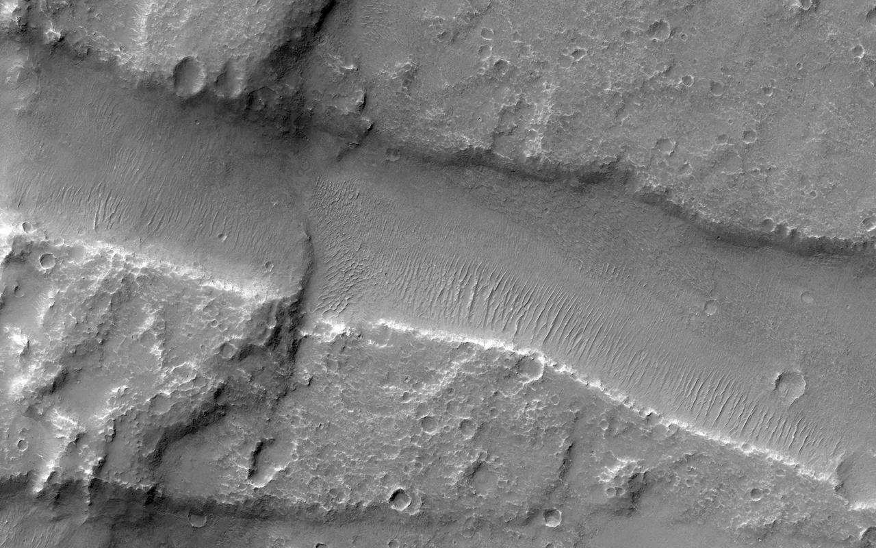
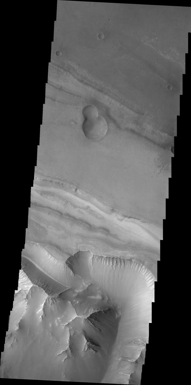
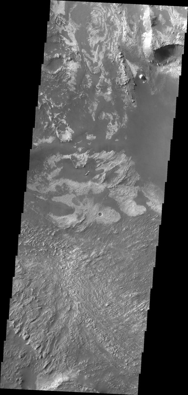
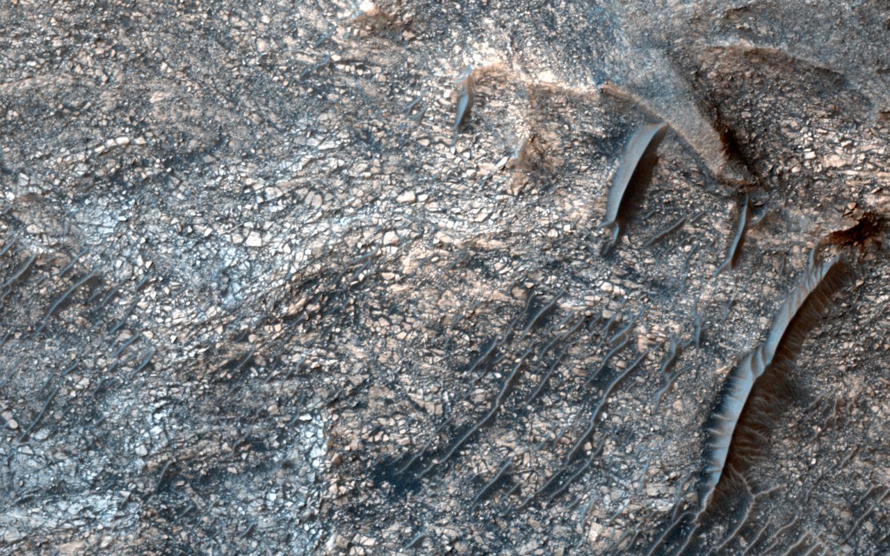
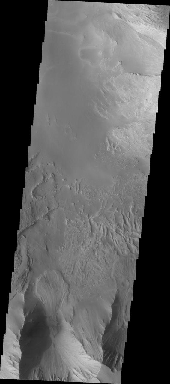
Melas Chasma is part of the largest canyon system on Mars, Valles Marineris. At only 563 km long (349 miles) it is not the longest canyon, but it is the widest. Located in the center of Valles Marineris, it has depths up to 9 km below the surrounding plains, and is the location of many large landslide deposits, as will as layered materials and sand dunes. There is evidence of both water and wind action as modes of formation for many of the interior deposits. This VIS image is located along the northern side of the chasma. The linear features are on the surface of a large landslide. This region of Melas Chasma is covered by several very large landslide deposits. The Odyssey spacecraft has spent over 15 years in orbit around Mars, circling the planet more than 69000 times. It holds the record for longest working spacecraft at Mars. THEMIS, the IR/VIS camera system, has collected data for the entire mission and provides images covering all seasons and lighting conditions. Over the years many features of interest have received repeated imaging, building up a suite of images covering the entire feature. From the deepest chasma to the tallest volcano, individual dunes inside craters and dune fields that encircle the north pole, channels carved by water and lava, and a variety of other feature, THEMIS has imaged them all. For the next several months the image of the day will focus on the Tharsis volcanoes, the various chasmata of Valles Marineris, and the major dunes fields. We hope you enjoy these images! Orbit Number: 36020 Latitude: -9.09641 Longitude: 288.172 Instrument: VIS Captured: 2010-01-27 03:51 https://photojournal.jpl.nasa.gov/catalog/PIA22138
The THEMIS VIS camera contains 5 filters. The data from different filters can be combined in multiple ways to create a false color image. This false color image from NASA 2001 Mars Odyssey spacecraft shows part of Melas Chasma. Orbit Number: 4622 Latitude: -12.797 Longitude: 288.629 Instrument: VIS Captured: 2002-12-30 00:28 http://photojournal.jpl.nasa.gov/catalog/PIA19218
The THEMIS VIS camera contains 5 filters. The data from different filters can be combined in multiple ways to create a false color image. These false color images may reveal subtle variations of the surface not easily identified in a single band image. Today's false color image shows part of Melas Chasma. Orbit Number: 10289 Latitude: -9.9472 Longitude: 285.933 Instrument: VIS Captured: 2004-04-09 12:43 http://photojournal.jpl.nasa.gov/catalog/PIA19756
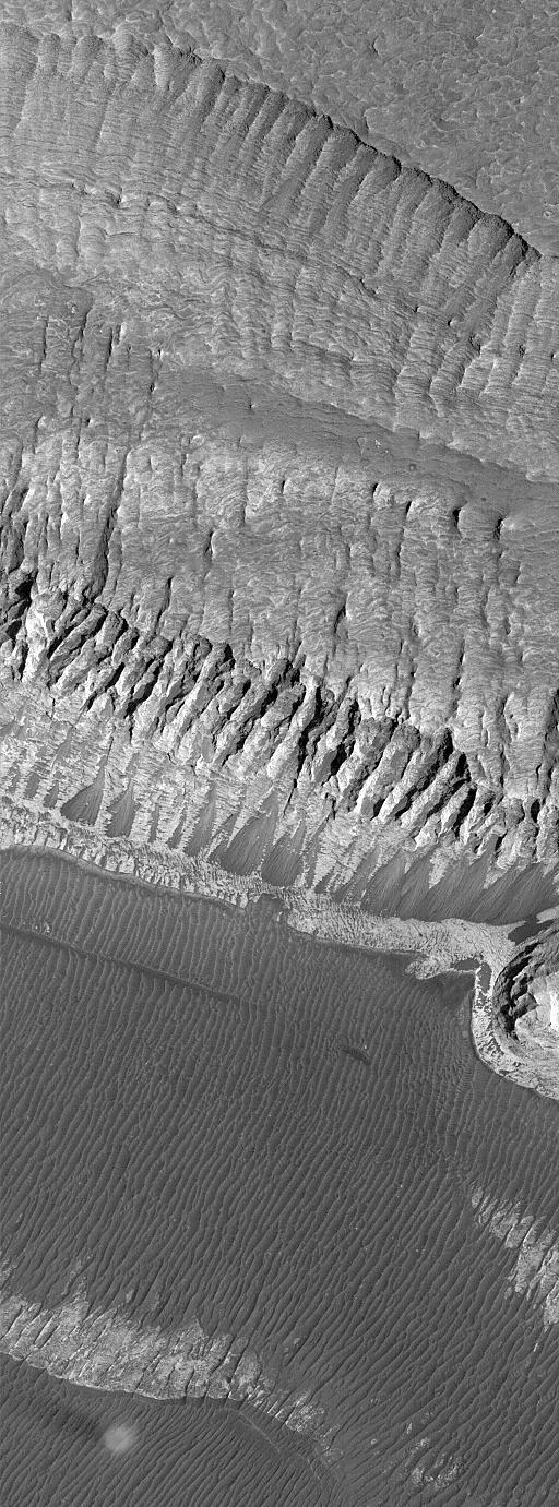
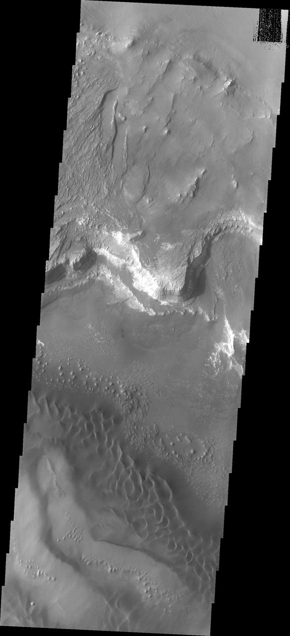
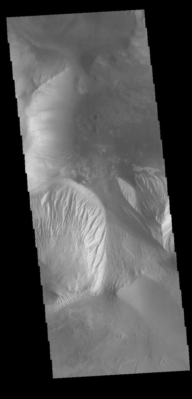
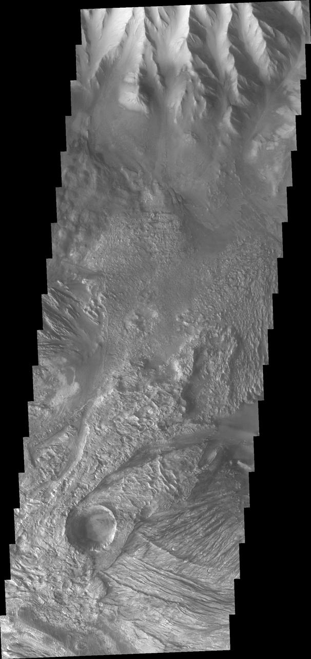
Melas Chasma is part of the largest canyon system on Mars, Valles Marineris. At only 563 km long (349 miles) it is not the longest canyon, but it is the widest. Located in the center of Valles Marineris, it has depths up to 9 km below the surrounding plains, and is the location of many large landslide deposits, as will as layered materials and sand dunes. There is evidence of both water and wind action as modes of formation for many of the interior deposits. Today's image covers part of the floor of the canyon. At the top of the image is one of the many hills found on the floor in this region. The linear grooved surface is part of a landslide deposit. Melas Chasma has many large landslide regions. Landslide deposits often have grooved surfaces with the grooves parallel to the direction of movement as the slide occurred. The ends of the landslide typically have a lobate edge, and will flow around large preexisting landforms. The Odyssey spacecraft has spent over 15 years in orbit around Mars, circling the planet more than 69000 times. It holds the record for longest working spacecraft at Mars. THEMIS, the IR/VIS camera system, has collected data for the entire mission and provides images covering all seasons and lighting conditions. Over the years many features of interest have received repeated imaging, building up a suite of images covering the entire feature. From the deepest chasma to the tallest volcano, individual dunes inside craters and dune fields that encircle the north pole, channels carved by water and lava, and a variety of other feature, THEMIS has imaged them all. For the next several months the image of the day will focus on the Tharsis volcanoes, the various chasmata of Valles Marineris, and the major dunes fields. We hope you enjoy these images! Orbit Number: 19112 Latitude: -11.1675 Longitude: 289.748 Instrument: VIS Captured: 2006-04-05 23:00 https://photojournal.jpl.nasa.gov/catalog/PIA22132
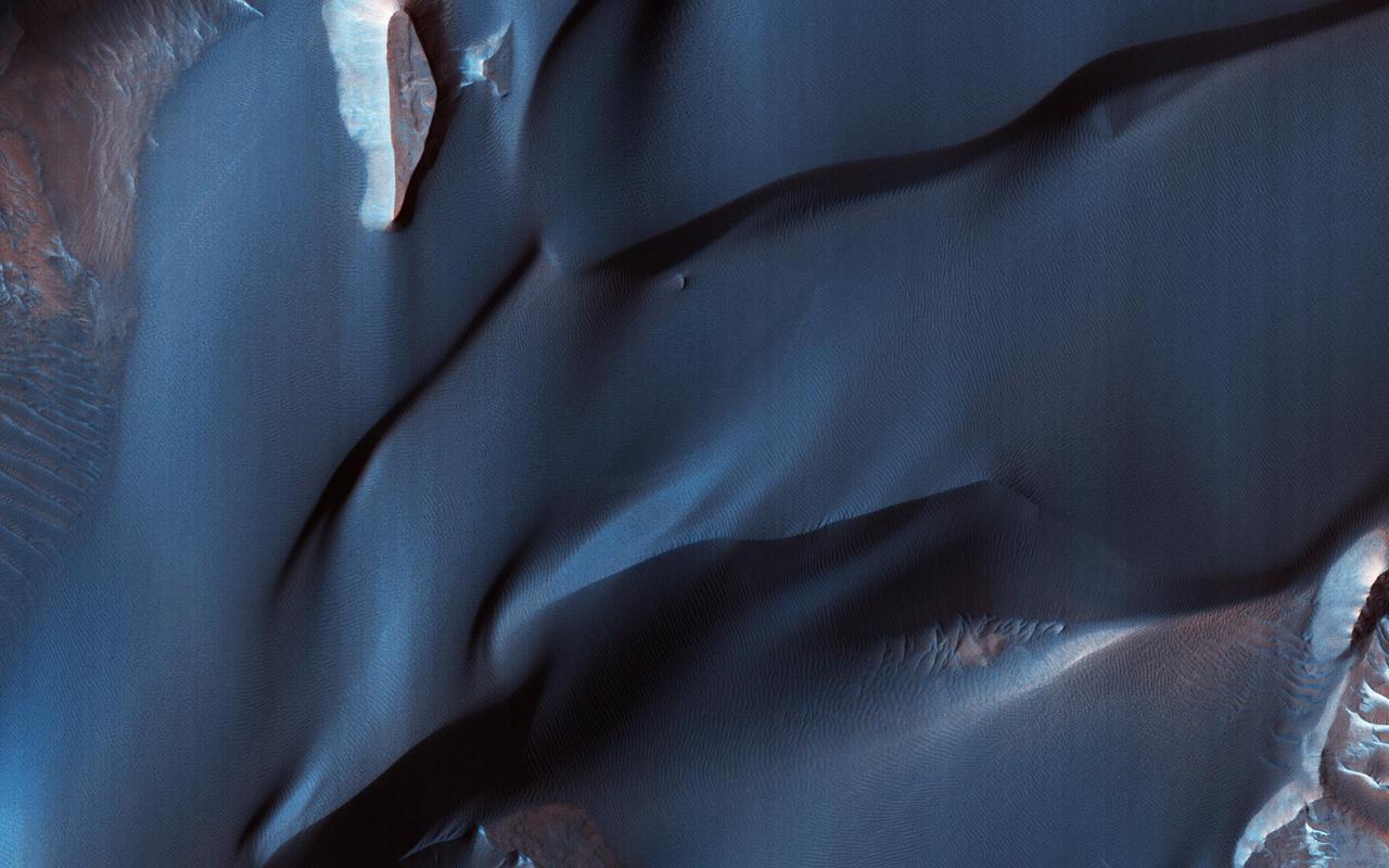
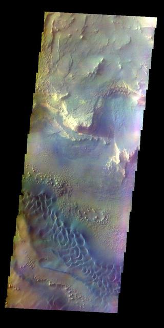
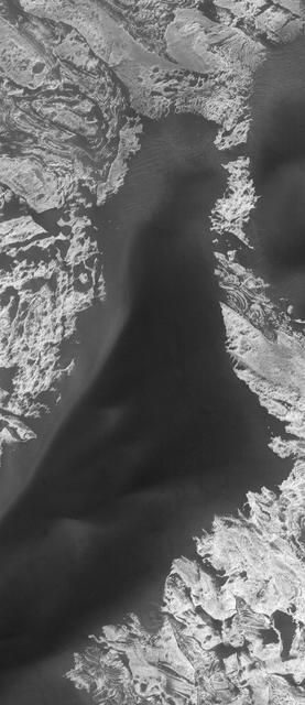
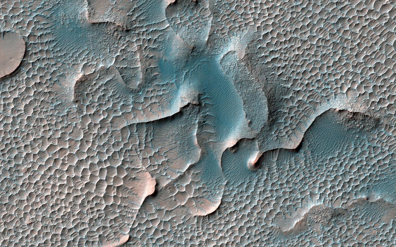
This color-infrared image shows sand dunes in Melas Chasma, located within the Valles Marineris canyon system. The dark-blue and purple colors indicate coarse-grained sands that are comprised of basalt, an iron and magnesium-rich volcanic rock that formed from cooled lava millions of years ago when volcanism was an active process on Mars. Migrating sand dunes often lead to the erosion and excavation of underlying material; regions where there are active dune fields are ideal places to search for exposed bedrock. Repeated imaging of dunes may also show changes that provide evidence for active surface processes related to wind patterns and climate. More information is available at https://photojournal.jpl.nasa.gov/catalog/PIA22783
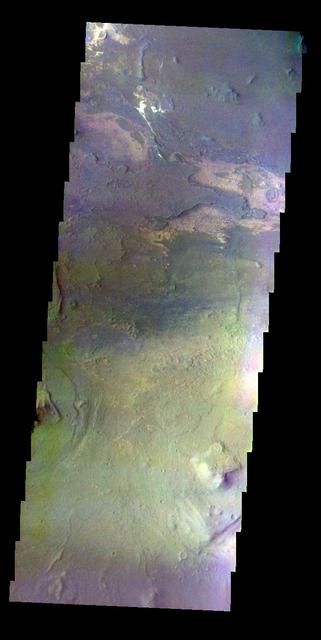
The THEMIS VIS camera contains 5 filters. The data from different filters can be combined in multiple ways to create a false color image. These false color images may reveal subtle variations of the surface not easily identified in a single band image. Today's false color image shows part of the floor of Melas Chasma. The dark blue region in this false color image is sand dunes. Orbit Number: 12061 Latitude: -12.2215 Longitude: 289.105 Instrument: VIS Captured: 2004-09-02 10:11 http://photojournal.jpl.nasa.gov/catalog/PIA19793
Melas Chasma is part of the largest canyon system on Mars, Valles Marineris. At only 563 km long (349 miles) it is not the longest canyon, but it is the widest. Located in the center of Valles Marineris, it has depths up to 9 km below the surrounding plains, and is the location of many large landslide deposits, as will as layered materials and sand dunes. There is evidence of both water and wind action as modes of formation for many of the interior deposits. This VIS image is located along the northern cliff face of the chasma. The linear features are large landslide surfaces. A region of sand dunes is located along the change in elevation from the cliff face at the top of the image and the floor of the canyon at the bottom of the image. The Odyssey spacecraft has spent over 15 years in orbit around Mars, circling the planet more than 69000 times. It holds the record for longest working spacecraft at Mars. THEMIS, the IR/VIS camera system, has collected data for the entire mission and provides images covering all seasons and lighting conditions. Over the years many features of interest have received repeated imaging, building up a suite of images covering the entire feature. From the deepest chasma to the tallest volcano, individual dunes inside craters and dune fields that encircle the north pole, channels carved by water and lava, and a variety of other feature, THEMIS has imaged them all. For the next several months the image of the day will focus on the Tharsis volcanoes, the various chasmata of Valles Marineris, and the major dunes fields. We hope you enjoy these images! Orbit Number: 31790 Latitude: -10.3951 Longitude: 290.141 Instrument: VIS Captured: 2009-02-12 20:47 https://photojournal.jpl.nasa.gov/catalog/PIA22137
This image captured by NASA 2001 Mars Odyssey spacecraft shows the region between Candor Chasma and Melas Chasma.
This MOC image shows dark sand dunes superposed on layered, light-toned outcrops -- interpreted to be sedimentary rocks -- in Melas Chasma. Melas Chasma is part of the enormous Valles Marineris trough system
This two-image mosaic shows part of the floor of Melas Chasma
This image shows a small portion of the layered deposits found in Melas Chasma
This part of Melas Chasma has been the target for many previous HiRISE images due to its diversity of terrains and materials. This observation covers an area not previously imaged, revealing a chaotic jumble of bright layered sediments, perhaps resulting from large landslides. In a closeup with enhanced colors, we can see an assortment of materials. Dark sand covers the low areas of the scene. https://photojournal.jpl.nasa.gov/catalog/PIA23063
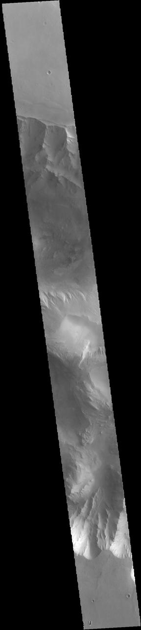
Melas Chasma is part of the largest canyon system on Mars, Valles Marineris. At only 563 km long (349 miles) it is not the longest canyon, but it is the widest. Located in the center of Valles Marineris, it has depths up to 9 km below the surrounding plains, and is the location of many large landslide deposits, as will as layered materials and sand dunes. There is evidence of both water and wind action as modes of formation for many of the interior deposits. This VIS image is located right at the edge of the canyon with the surrounding plains - the flat area at the bottom of the image. Some small landslide deposits are visible originating at the cliff side. The Odyssey spacecraft has spent over 15 years in orbit around Mars, circling the planet more than 69000 times. It holds the record for longest working spacecraft at Mars. THEMIS, the IR/VIS camera system, has collected data for the entire mission and provides images covering all seasons and lighting conditions. Over the years many features of interest have received repeated imaging, building up a suite of images covering the entire feature. From the deepest chasma to the tallest volcano, individual dunes inside craters and dune fields that encircle the north pole, channels carved by water and lava, and a variety of other feature, THEMIS has imaged them all. For the next several months the image of the day will focus on the Tharsis volcanoes, the various chasmata of Valles Marineris, and the major dunes fields. We hope you enjoy these images! Orbit Number: 26762 Latitude: -13.4233 Longitude: 287.973 Instrument: VIS Captured: 2007-12-26 19:46 https://photojournal.jpl.nasa.gov/catalog/PIA22136
Melas Chasma is part of the largest canyon system on Mars, Valles Marineris. At only 563 km long (349 miles) it is not the longest canyon, but it is the widest. Located in the center of Valles Marineris, it has depths up to 9 km below the surrounding plains, and is the location of many large landslide deposits, as will as layered materials and sand dunes. There is evidence of both water and wind action as modes of formation for many of the interior deposits. Today's image is just a bit further to the west of yesterday's. Here there are no dunes, but extensive outcrops of layered material. It is possible that these layered deposits were formed by sediments settling in a lake. The Odyssey spacecraft has spent over 15 years in orbit around Mars, circling the planet more than 69000 times. It holds the record for longest working spacecraft at Mars. THEMIS, the IR/VIS camera system, has collected data for the entire mission and provides images covering all seasons and lighting conditions. Over the years many features of interest have received repeated imaging, building up a suite of images covering the entire feature. From the deepest chasma to the tallest volcano, individual dunes inside craters and dune fields that encircle the north pole, channels carved by water and lava, and a variety of other feature, THEMIS has imaged them all. For the next several months the image of the day will focus on the Tharsis volcanoes, the various chasmata of Valles Marineris, and the major dunes fields. We hope you enjoy these images! Orbit Number: 4335 Latitude: -10.3718 Longitude: 285.195 Instrument: VIS Captured: 2002-12-06 09:30 https://photojournal.jpl.nasa.gov/catalog/PIA22135
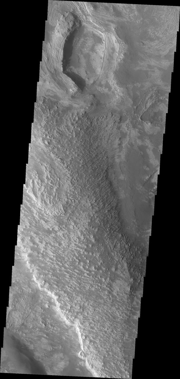
Melas Chasma is part of the largest canyon system on Mars, Valles Marineris. At only 563 km long (349 miles) it is not the longest canyon, but it is the widest. Located in the center of Valles Marineris, it has depths up to 9 km below the surrounding plains, and is the location of many large landslide deposits, as will as layered materials and sand dunes. There is evidence of both water and wind action as modes of formation for many of the interior deposits. Today's image contains a large region of dunes between the canyon cliff face and the large ridge of material at the mid-elevation of the canyon. Fine materials have been concentrated into the dunes. The Odyssey spacecraft has spent over 15 years in orbit around Mars, circling the planet more than 69000 times. It holds the record for longest working spacecraft at Mars. THEMIS, the IR/VIS camera system, has collected data for the entire mission and provides images covering all seasons and lighting conditions. Over the years many features of interest have received repeated imaging, building up a suite of images covering the entire feature. From the deepest chasma to the tallest volcano, individual dunes inside craters and dune fields that encircle the north pole, channels carved by water and lava, and a variety of other feature, THEMIS has imaged them all. For the next several months the image of the day will focus on the Tharsis volcanoes, the various chasmata of Valles Marineris, and the major dunes fields. We hope you enjoy these images! Orbit Number: 26525 Latitude: -11.3125 Longitude: 285.57 Instrument: VIS Captured: 2007-12-07 07:23 https://photojournal.jpl.nasa.gov/catalog/PIA22134
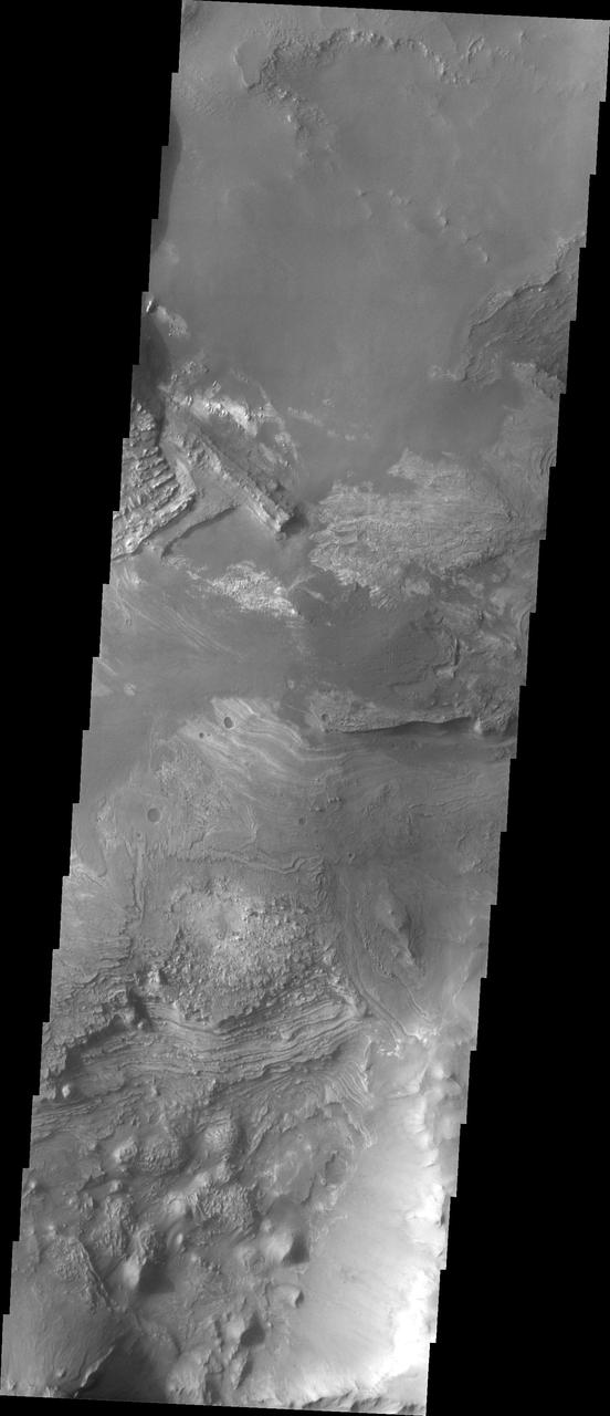
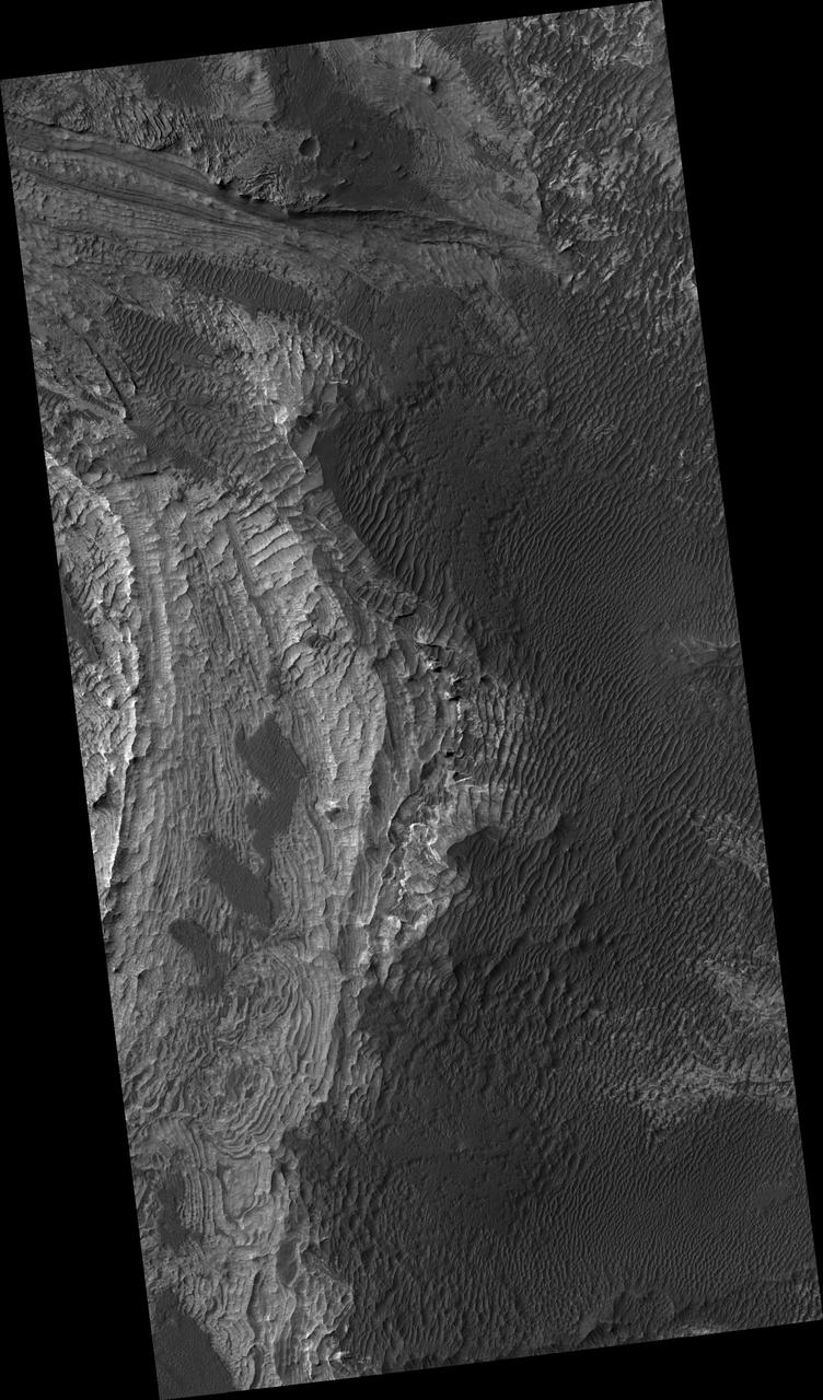
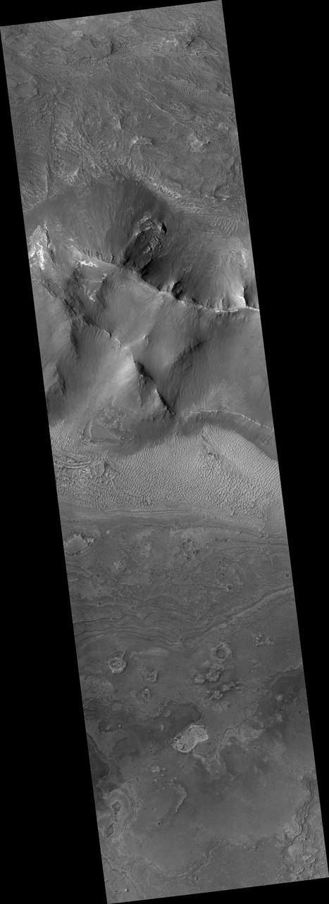
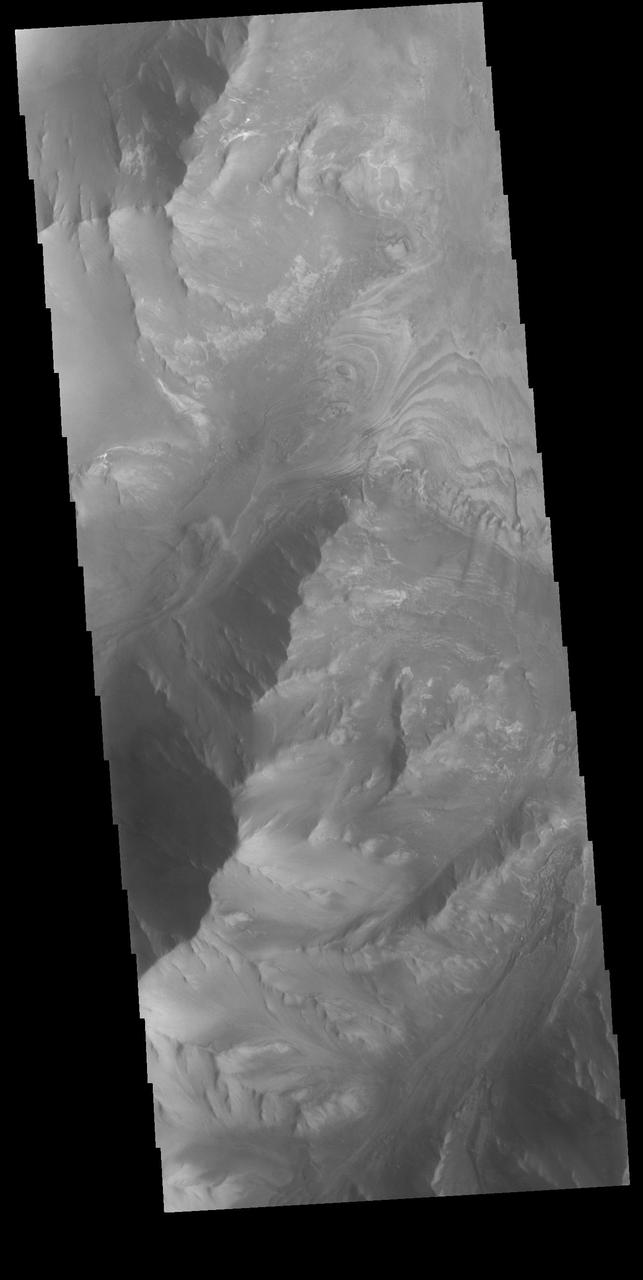
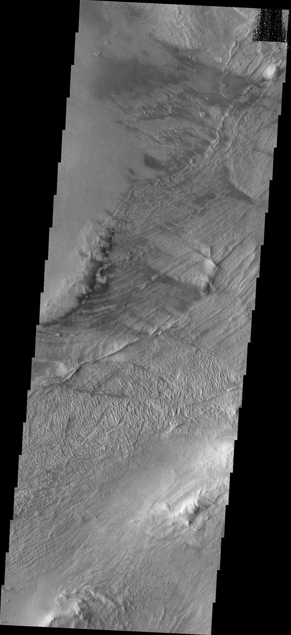
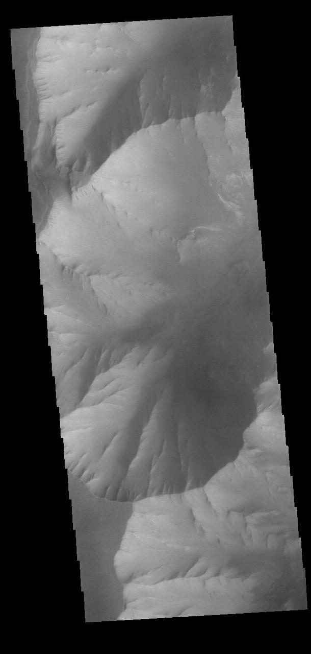
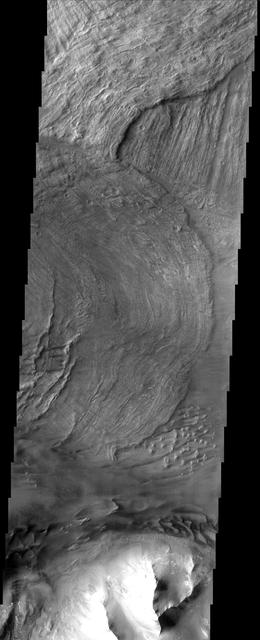
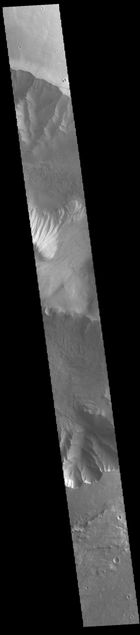
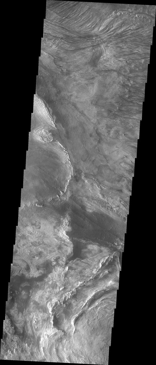
Melas Chasma is part of the largest canyon system on Mars, Valles Marineris. At only 563 km long (349 miles) it is not the longest canyon, but it is the widest. Located in the center of Valles Marineris, it has depths up to 9 km below the surrounding plains, and is the location of many large landslide deposits, as will as layered materials and sand dunes. There is evidence of both water and wind action as modes of formation for many of the interior deposits. This VIS image highlights the extent of layered materials within the canyon. The image is located on the mid elevations on the south side of the canyon. The Odyssey spacecraft has spent over 15 years in orbit around Mars, circling the planet more than 69000 times. It holds the record for longest working spacecraft at Mars. THEMIS, the IR/VIS camera system, has collected data for the entire mission and provides images covering all seasons and lighting conditions. Over the years many features of interest have received repeated imaging, building up a suite of images covering the entire feature. From the deepest chasma to the tallest volcano, individual dunes inside craters and dune fields that encircle the north pole, channels carved by water and lava, and a variety of other feature, THEMIS has imaged them all. For the next several months the image of the day will focus on the Tharsis volcanoes, the various chasmata of Valles Marineris, and the major dunes fields. We hope you enjoy these images! Orbit Number: 10813 Latitude: -13.1037 Longitude: 289.967 Instrument: VIS Captured: 2004-05-22 16:09 https://photojournal.jpl.nasa.gov/catalog/PIA22129
Melas Chasma is part of the largest canyon system on Mars, Valles Marineris. At only 563 km long (349 miles) it is not the longest canyon, but it is the widest. Located in the center of Valles Marineris, it has depths up to 9 km below the surrounding plains, and is the location of many large landslide deposits, as will as layered materials and sand dunes. There is evidence of both water and wind action as modes of formation for many of the interior deposits. Today's image of the southern section of the canyon shows a large region of sand dunes. The presence of dunes indicates wind action as the most recent geologic process modifying the canyon. The Odyssey spacecraft has spent over 15 years in orbit around Mars, circling the planet more than 69000 times. It holds the record for longest working spacecraft at Mars. THEMIS, the IR/VIS camera system, has collected data for the entire mission and provides images covering all seasons and lighting conditions. Over the years many features of interest have received repeated imaging, building up a suite of images covering the entire feature. From the deepest chasma to the tallest volcano, individual dunes inside craters and dune fields that encircle the north pole, channels carved by water and lava, and a variety of other feature, THEMIS has imaged them all. For the next several months the image of the day will focus on the Tharsis volcanoes, the various chasmata of Valles Marineris, and the major dunes fields. We hope you enjoy these images! Orbit Number: 18513 Latitude: -12.752 Longitude: 288.597 Instrument: VIS Captured: 2006-02-15 15:24 https://photojournal.jpl.nasa.gov/catalog/PIA22131
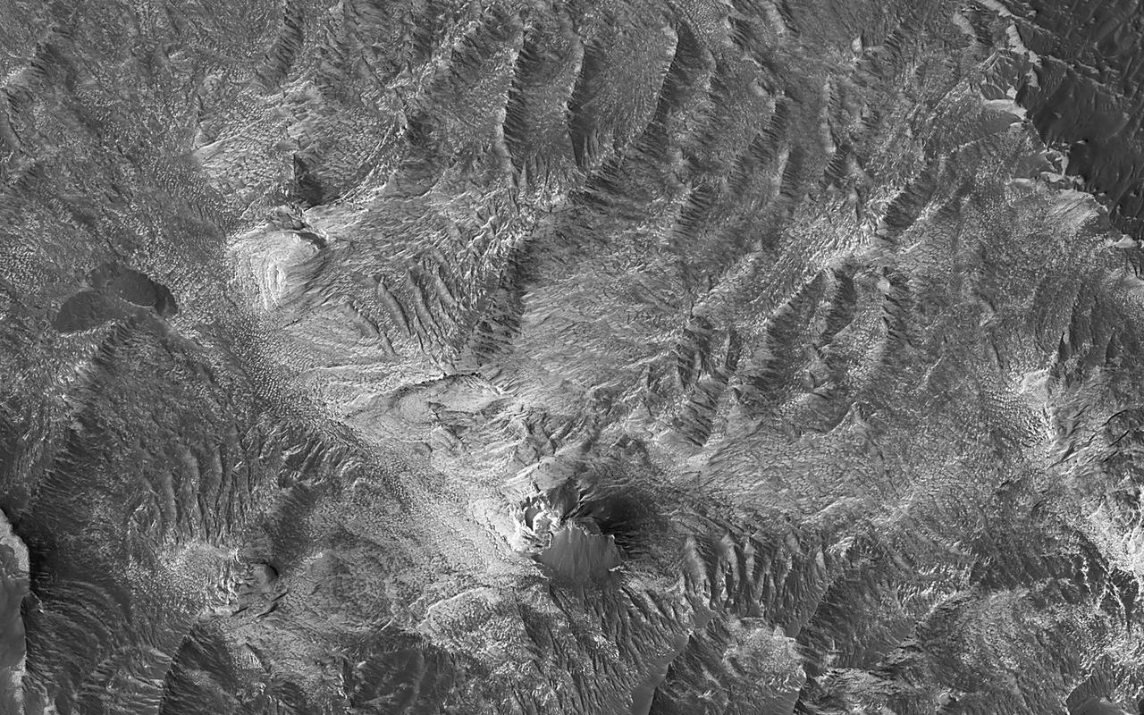
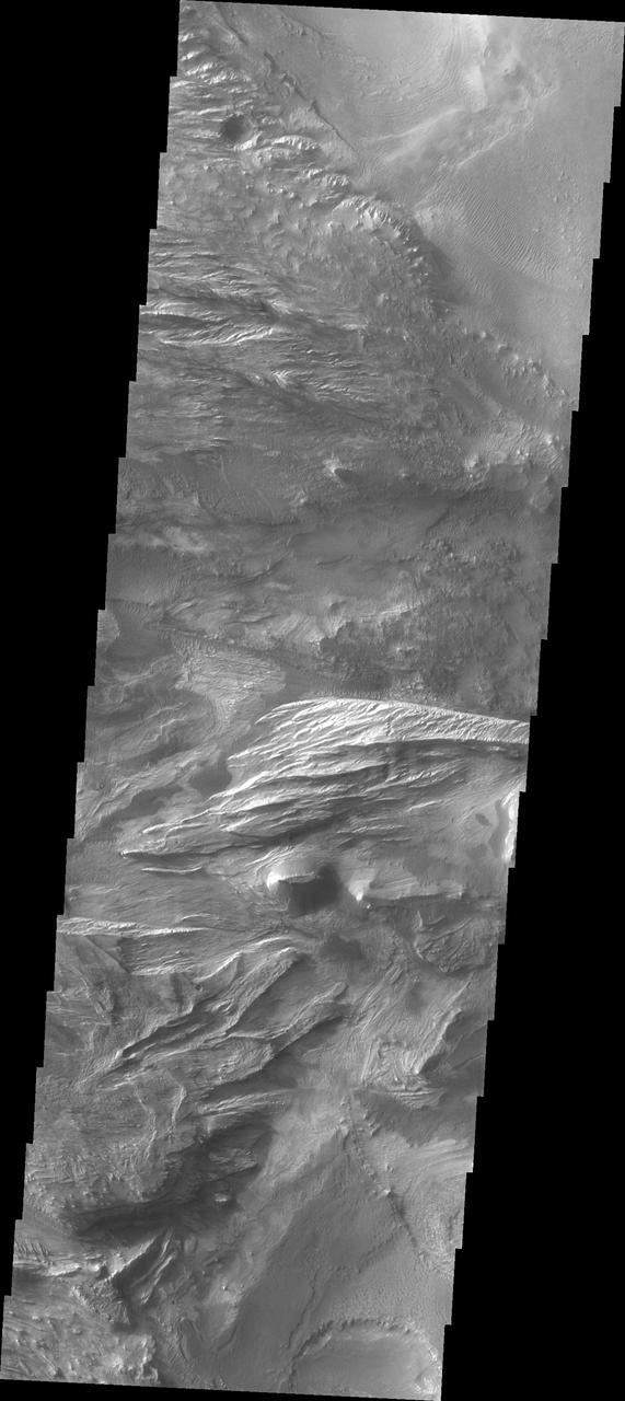
Melas Chasma is part of the largest canyon system on Mars, Valles Marineris. At only 563 km long (349 miles) it is not the longest canyon, but it is the widest. Located in the center of Valles Marineris, it has depths up to 9 km below the surrounding plains, and is the location of many large landslide deposits, as will as layered materials and sand dunes. There is evidence of both water and wind action as modes of formation for many of the interior deposits. This VIS image shows part of a large ridge of material near the south central part the canyon. The roughest looking material is the top of the ridge. The Odyssey spacecraft has spent over 15 years in orbit around Mars, circling the planet more than 69000 times. It holds the record for longest working spacecraft at Mars. THEMIS, the IR/VIS camera system, has collected data for the entire mission and provides images covering all seasons and lighting conditions. Over the years many features of interest have received repeated imaging, building up a suite of images covering the entire feature. From the deepest chasma to the tallest volcano, individual dunes inside craters and dune fields that encircle the north pole, channels carved by water and lava, and a variety of other feature, THEMIS has imaged them all. For the next several months the image of the day will focus on the Tharsis volcanoes, the various chasmata of Valles Marineris, and the major dunes fields. We hope you enjoy these images! Orbit Number: 16741 Latitude: -10.6629 Longitude: 285.637 Instrument: VIS Captured: 2005-09-22 17:54 https://photojournal.jpl.nasa.gov/catalog/PIA22130
Melas Chasma is part of the largest canyon system on Mars, Valles Marineris. At only 563 km long (349 miles) it is not the longest canyon, but it is the widest. Located in the center of Valles Marineris, it has depths up to 9 km from the surrounding plains, and is the location of many large landslide deposits, as will as layered materials and sand dunes. There is evidence of both water and wind action as modes of formation for many of the interior deposits. This VIS image shows layered materials and sand dunes. The image is located on the mid elevations on the south side of the canyon. The Odyssey spacecraft has spent over 15 years in orbit around Mars, circling the planet more than 69000 times. It holds the record for longest working spacecraft at Mars. THEMIS, the IR/VIS camera system, has collected data for the entire mission and provides images covering all seasons and lighting conditions. Over the years many features of interest have received repeated imaging, building up a suite of images covering the entire feature. From the deepest chasma to the tallest volcano, individual dunes inside craters and dune fields that encircle the north pole, channels carved by water and lava, and a variety of other feature, THEMIS has imaged them all. For the next several months the image of the day will focus on the Tharsis volcanoes, the various chasmata of Valles Marineris, and the major dunes fields. We hope you enjoy these images! Orbit Number: 10838 Latitude: -12.7865 Longitude: 288.837 Instrument: VIS Captured: 2004-05-24 17:32 https://photojournal.jpl.nasa.gov/catalog/PIA22128
This image captured by NASA 2001 Mars Odyssey spacecraft is further west from yesterday image, near the margin between Coprates Chasma and Melas Chasma.
This image shows paret of the west end of Melas Chasma. Landslide deposits are visible at the top of the image, with dark dunes appearing at the bottom
This image captured by NASA 2001 Mars Odyssey spacecraft shows part of the north wall of Valles Marineris near Melas Chasma.

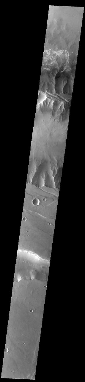
This Mars Odyssey image transects Candor Chasma and Melas Chasma. Many canyon features are clearly visible in the image, including the steep cliff faces, landslides, and layered canyon floor deposits.
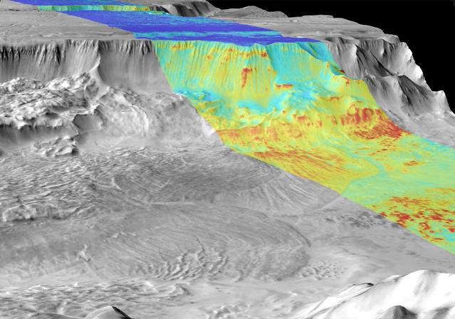
It has been known since the 1970s when the Viking orbiters took pictures of Mars that there are large (i.e., several kilometers-thick) mounds of light-toned deposits within the central portion of Valles Marineris. More recent higher resolution images of Mars, including this image of Melas Chasma, show that the wall rocks of Valles Mariners also contain similar, albeit thinner, light-toned deposits. Spectral data from the CRISM instrument indicate that the larger mounds are composed of sulfates. Some of the wall rock deposits are also made up of sulfates, but others contain clays or mixtures of several kinds of hydrated materials, suggesting that multiple aqueous processes, perhaps at different times within Valles Marineris, formed the variety of deposits we now observe. http://photojournal.jpl.nasa.gov/catalog/PIA21102

This spectacular view, taken by NASA 2001 Mars Odyssey, shows the sunlit cliffs and basaltic sand dunes in southern Melas Chasma shows Mars in a way rarely seen: in full, realistic color.
Today's VIS image shows part of Candor Chasma. Candor Chasma is one of the largest canyons that make up Valles Marineris. It is approximately 810 km long (503 miles) and has is divided into two regions – eastern and western Candor Chasma. Candor Chasma is located south of Ophir Chasma and north of Melas Chasma. The border with Melas Chasma contains many large landslide deposits. The floor of Candor Chasma includes a variety of landforms, including layered deposits, dunes, landslide deposits and steep sided cliffs and mesas. Many forms of erosion have shaped Candor Chasma. There is evidence of wind and water erosion, as well as significant gravity driven mass wasting (landslides). The bright features in this image are layered deposits that have been eroded by wind, and possible water. Orbit Number: 89623 Latitude: -6.93421 Longitude: 291.118 Instrument: VIS Captured: 2022-02-26 20:41 https://photojournal.jpl.nasa.gov/catalog/PIA25451
This canyon system imaged here by NASA Mars Odyssey was named Valles Marineris in honor of its discoverer, NASA Mariner 9 spacecraft. The image covers a portion of the canyon system called Melas Chasma. http://photojournal.jpl.nasa.gov/catalog/PIA04003
Today's VIS image shows part of eastern Candor Chasma. Candor Chasma is one of the largest canyons that make up Valles Marineris. It is approximately 810 km long (503 miles) and has is divided into two regions - eastern and western Candor. Candor is located south of Ophir Chasma and north of Melas Chasma. The border with Melas Chasma contains many large landslide deposits. The floor of Candor Chasma includes a variety of landforms, including layered deposits, dunes, landslide deposits and steep sided cliffs and mesas. Many forms of erosion have shaped Candor Chasma. There is evidence of wind and water erosion, as well as significant gravity driven mass wasting (landslides). Orbit Number: 88163 Latitude: -7.04697 Longitude: 292.058 Instrument: VIS Captured: 2021-10-29 15:27 https://photojournal.jpl.nasa.gov/catalog/PIA25152
Today's VIS image shows part of eastern Candor Chasma. Candor Chasma is one of the largest canyons that make up Valles Marineris. It is approximately 810 km long (503 miles) and is divided into two regions – eastern and western Candor. Candor is located south of Ophir Chasma and north of Melas Chasma. The border with Melas Chasma contains many large landslide deposits. The floor of Candor Chasma includes a variety of landforms, including layered deposits (bright region in the center of the image), dunes, landslide deposits and steep sided cliffs and mesas. Many forms of erosion have shaped Candor Chasma. There is evidence of wind and water erosion, as well as significant gravity driven mass wasting (landslides). Orbit Number: 85817 Latitude: -6.96093 Longitude: 291.605 Instrument: VIS Captured: 2021-04-19 11:28 https://photojournal.jpl.nasa.gov/catalog/PIA24875
Candor Chasma is one of the largest canyons that make up Valles Marineris. It is approximately 810 km long (503 miles) and is divided into two regions – eastern and western Candor. Candor Chasma is located south of Ophir Chasma and north of Melas Chasma. The border with Melas Chasma contains many large landslide deposits. The floor of Candor Chasma includes a variety of landforms, including layered deposits, dunes, landslide deposits and steep sided cliffs and mesas. Many forms of erosion have shaped Candor Chasma. There is evidence of wind and water erosion, as well as significant gravity driven mass wasting (landslides). Orbit Number: 95151 Latitude: -7.05226 Longitude: 291.676 Instrument: VIS Captured: 2023-05-28 00:49 https://photojournal.jpl.nasa.gov/catalog/PIA26263
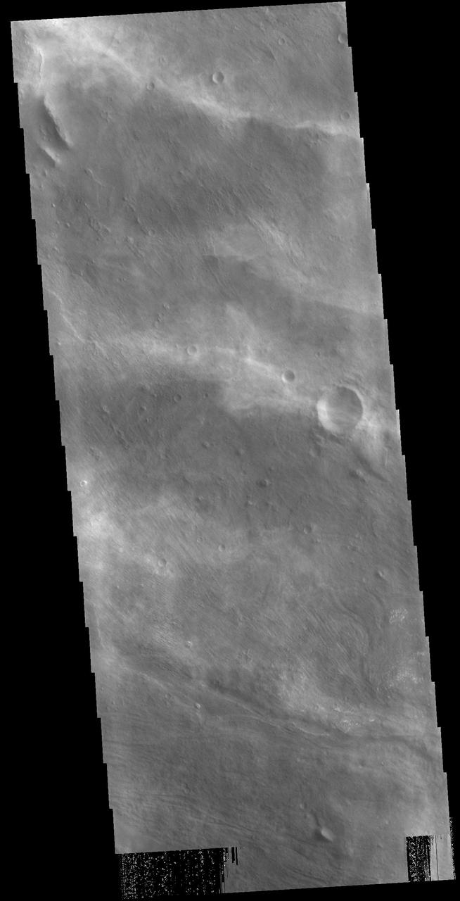
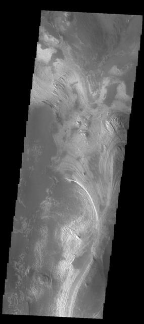
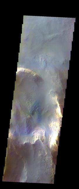
The diffuse streaks of white in this VIS image are clouds. These are high altitude winter clouds over Melas Chasma. Streamers of clouds like this are moving very quickly in high altitude winds. Orbit Number: 88213 Latitude: -11.5665 Longitude: 290.207 Instrument: VIS Captured: 2021-11-02 18:14 https://photojournal.jpl.nasa.gov/catalog/PIA25195
Candor Chasma is one of the largest canyons that make up Valles Marineris. It is approximately 810 km long (503 miles) and is divided into two regions - eastern and western Candor. Candor is located south of Ophir Chasma and north of Melas Chasma. The border with Melas Chasma contains many large landslide deposits. The floor of Candor Chasma includes a variety of landforms, including layered deposits, dunes, landslide deposits and steep sided cliffs and mesas. Many forms of erosion have shaped Candor Chasma. There is evidence of wind and water erosion, as well as significant gravity driven mass wasting (landslides). Orbit Number: 94789 Latitude: -8.22898 Longitude: 295.219 Instrument: VIS Captured: 2023-04-28 05:27 https://photojournal.jpl.nasa.gov/catalog/PIA26158
Today's VIS image is located between the main part of Coprates Chasma (north) and Coprates Catena (south). The canyon in this area is much shallower than the main canyon. Coprates Chasma is one of the numerous canyons that make up Valles Marineris. The chasma stretches for 960 km (600 miles) from Melas Chasma to the west and Capri Chasma to the east. Orbit Number: 90883 Latitude: -15.0445 Longitude: 301.518 Instrument: VIS Captured: 2022-06-10 14:37 https://photojournal.jpl.nasa.gov/catalog/PIA25516
This image taken by NASA 2001 Mars Odyssey shows a portion of the floor of Melsa Chasma. Wind blown material is located in lows between layered floor materials.
The floor of Melsa Chasma contains a variety of landforms. This image from NASA 2001 Mars Odyssey shows deposits of fine materials as well as layered deposits.
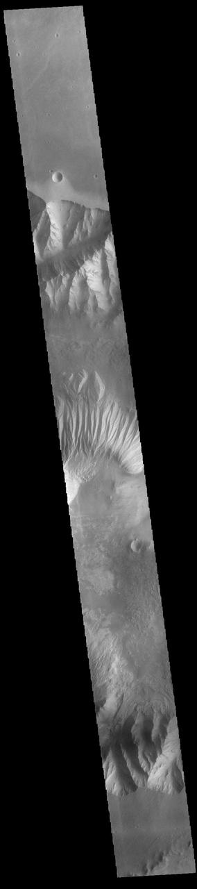
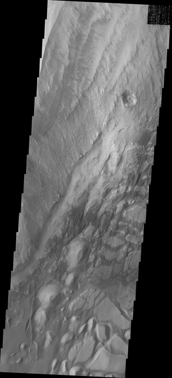
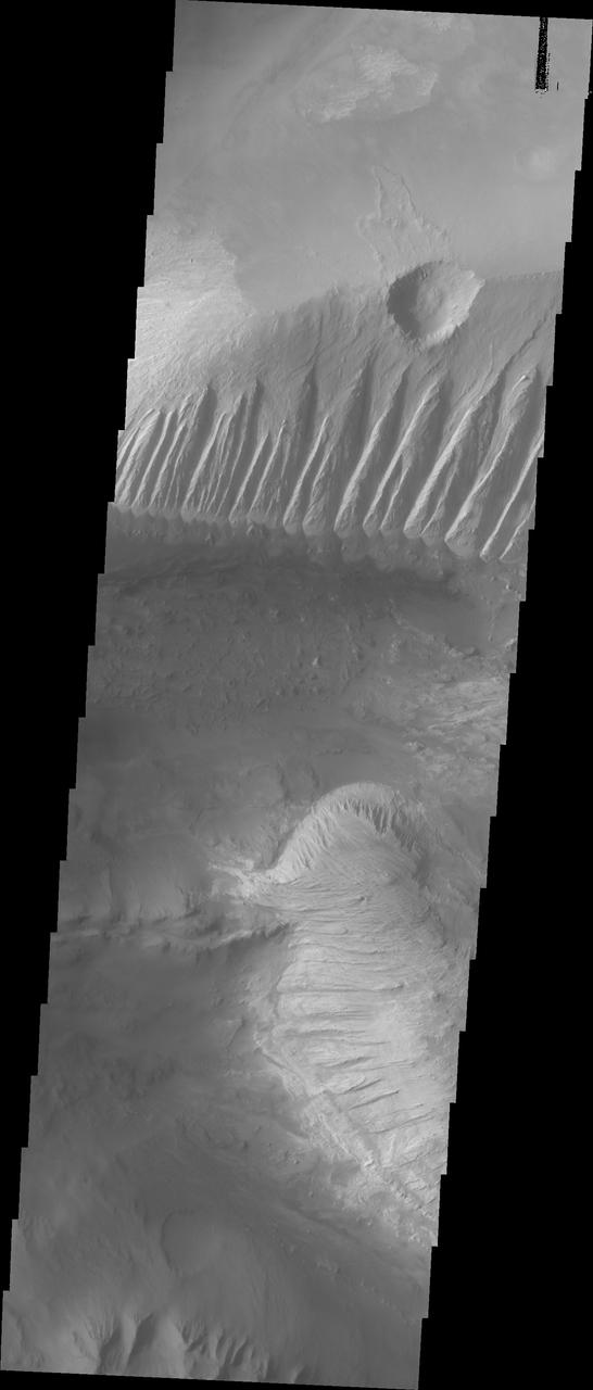
Today's VIS image shows part of the northern cliff face of Melas Chasma and the large landslide deposits at the base of the cliff face. The landslide deposits are called Ophir Labes. The descriptor term labes means landslide. Orbit Number: 74275 Latitude: -9.66666 Longitude: 290.547 Instrument: VIS Captured: 2018-09-12 01:22 https://photojournal.jpl.nasa.gov/catalog/PIA22797
This VIS image is located on the eastern side of Coprates Chasma, near Capri Chasma. The image shows a large lobe shaped landslide deposit at the bottom of the canyon cliff face. Sand dunes are visible both on the landslide deposit and other parts of the canyon floor. Coprates Chasma is one of the numerous canyons that make up Valles Marineris. The chasma stretches for 960 km (600 miles) from Melas Chasma to the west and Capri Chasma to the east. Landslide deposits, layered materials and sand dunes cover a large portion of the chasma floor. Orbit Number: 88225 Latitude: -15.0285 Longitude: 304.496 Instrument: VIS Captured: 2021-11-03 17:56 https://photojournal.jpl.nasa.gov/catalog/PIA25196

Today's VIS image shows a cross section of Coprates Chasma. The floor of the canyon is covered by large landslide deposits. Coprates Chasma is one of the numerous canyons that make up Valles Marineris. The chasma stretches for 960 km (600 miles) from Melas Chasma to the west and Capri Chasma to the east. Paralleling the chasma to the south runs a narrower and shallower chain of linked pits and depressions called Coprates Catena. Orbit Number: 93011 Latitude: -14.3186 Longitude: 299.989 Instrument: VIS Captured: 2022-12-02 19:04 https://photojournal.jpl.nasa.gov/catalog/PIA25811
Today's VIS image shows a cross section of Coprates Chasma. In this region the chasma has two sections – a deep, flat floored canyon at the top of the image, and a shallower section in the lower part of the image. The sections are divided by a large ridge. The floor of the bottom canyon is covered by large landslide deposits. Coprates Chasma is one of the numerous canyons that make up Valles Marineris. The chasma stretches for 960 km (600 miles) from Melas Chasma to the west and Capri Chasma to the east. Orbit Number: 91988 Latitude: -12.6995 Longitude: 293.287 Instrument: VIS Captured: 2022-09-09 13:27 https://photojournal.jpl.nasa.gov/catalog/PIA25717
Today's VIS image shows part of the southern margin of Candor Chasma. While not as deep as the northern regions of eastern Candor Chasma, the southern region contains all the features seen at the lower elevations to the north. Candor Chasma is one of the largest canyons that make up Valles Marineris. It is approximately 810 km long (503 miles) and is divided into two regions - eastern and western Candor. Candor is located south of Ophir Chasma and north of Melas Chasma. The border with Melas Chasma contains many large landslide deposits. The floor of Candor Chasma includes a variety of landforms, including layered deposits, dunes, landslide deposits and steep sided cliffs and mesas. Many forms of erosion have shaped Candor Chasma. There is evidence of wind and water erosion, as well as significant gravity driven mass wasting (landslides). Orbit Number: 89860 Latitude: -8.00834 Longitude: 293.829 Instrument: VIS Captured: 2022-03-18 09:02 https://photojournal.jpl.nasa.gov/catalog/PIA25398
The THEMIS VIS camera contains 5 filters. The data from different filters can be combined in multiple ways to create a false color image. These false color images may reveal subtle variations of the surface not easily identified in a single band image. Today's false color image shows part of western Candor Chasma. Candor Chasma is one of the largest canyons that make up Valles Marineris. It is approximately 810 km long (503 miles) and has is divided into two regions — eastern and western Candor. Candor is located south of Ophir Chasma and north of Melas Chasma. The border with Melas Chasma contains many large landslide deposits. The floor of Candor Chasma includes a variety of landforms, including layered deposits, dunes, landslide deposits and steep sided cliffs and mesas. Many forms of erosion have shaped Candor Chasma. There is evidence of wind and water erosion, as well as significant gravity driven mass wasting (landslides). Orbit Number: 69411 Latitude: -5.95186 Longitude: 283.147 Instrument: VIS Captured: 2017-08-07 08:33 https://photojournal.jpl.nasa.gov/catalog/PIA24081
Today's VIS image shows part of the large hill near the eastern edge of Candor Chasma. Layering is visible toward the bottom of the image. The sides of the hill are deeply incised by erosion, probably including both wind and water processes. Candor Chasma is one of the largest canyons that make up Valles Marineris. It is approximately 810 km long (503 miles) and has is divided into two regions - eastern and western Candor. Candor is located south of Ophir Chasma and north of Melas Chasma. The border with Melas Chasma contains many large landslide deposits. The floor of Candor Chasma includes a variety of landforms, including layered deposits, dunes, landslide deposits and steep sided cliffs and mesas. Many forms of erosion have shaped Candor Chasma. There is evidence of wind and water erosion, as well as significant gravity driven mass wasting (landslides). Orbit Number: 88687 Latitude: -7.91852 Longitude: 294.829 Instrument: VIS Captured: 2021-12-11 18:58 https://photojournal.jpl.nasa.gov/catalog/PIA25202
The THEMIS VIS camera contains 5 filters. The data from different filters can be combined in multiple ways to create a false color image. These false color images may reveal subtle variations of the surface not easily identified in a single band image. Today's false color image shows part of Candor Chasma. Candor Chasma is one of the largest canyons that make up Valles Marineris. It is approximately 810 km long (503 miles) and has is divided into two regions – eastern and western Candor. Candor is located south of Ophir Chasma and north of Melas Chasma. The border with Melas Chasma contains many large landslide deposits. The floor of Candor Chasma includes a variety of landforms, including layered deposits (seen in this image), dunes, landslide deposits and steep sided cliffs and mesas. Many forms of erosion have shaped Candor Chasma. There is evidence of wind and water erosion, as well as significant gravity driven mass wasting (landslides). Orbit Number: 71132 Latitude: -6.71232 Longitude: 284.46 Instrument: VIS Captured: 2017-12-27 03:31 https://photojournal.jpl.nasa.gov/catalog/PIA24508
The THEMIS VIS camera contains 5 filters. The data from different filters can be combined in multiple ways to create a false color image. These false color images may reveal subtle variations of the surface not easily identified in a single band image. Today's false color image shows part of eastern Candor Chasma. Candor Chasma is one of the largest canyons that make up Valles Marineris. It is approximately 810 km long (503 miles) and has is divided into two regions — eastern and western Candor. Candor is located south of Ophir Chasma and north of Melas Chasma. The border with Melas Chasma contains many large landslide deposits. The floor of Candor Chasma includes a variety of landforms, including layered deposits, dunes, landslide deposits and steep sided cliffs and mesas. Many forms of erosion have shaped Candor Chasma. There is evidence of wind and water erosion, as well as significant gravity driven mass wasting (landslides). Orbit Number: 68438 Latitude: -7.05392 Longitude: 291.853 Instrument: VIS Captured: 2017-05-19 04:30 https://photojournal.jpl.nasa.gov/catalog/PIA24078
Today's VIS image shows a cross section of eastern Candor Chasma. In the center of this image is a large hill. The sides of the hill are deeply incised by erosion, probably including both wind and water processes. Candor Chasma is one of the largest canyons that make up Valles Marineris. It is approximately 810 km long (503 miles) and has is divided into two regions – eastern and western Candor. Candor is located south of Ophir Chasma and north of Melas Chasma. The border with Melas Chasma contains many large landslide deposits. The floor of Candor Chasma includes a variety of landforms, including layered deposits, dunes, landslide deposits and steep sided cliffs and mesas. Many forms of erosion have shaped Candor Chasma. There is evidence of wind and water erosion, as well as significant gravity driven mass wasting (landslides). Orbit Number: 89548 Latitude: -7.8126 Longitude: 294.967 Instrument: VIS Captured: 2022-02-20 16:28 https://photojournal.jpl.nasa.gov/catalog/PIA25379
Sand dunes are found in many places on Mars. At most of these places the dunes are slowly moving, blown by the wind, just like on Earth. However, in this location in south Melas Chasma they appear to have turned to stone. The large dunes are slowly being eroded and disappearing, replaced by smaller structures of scalloped sand. https://photojournal.jpl.nasa.gov/catalog/PIA23668
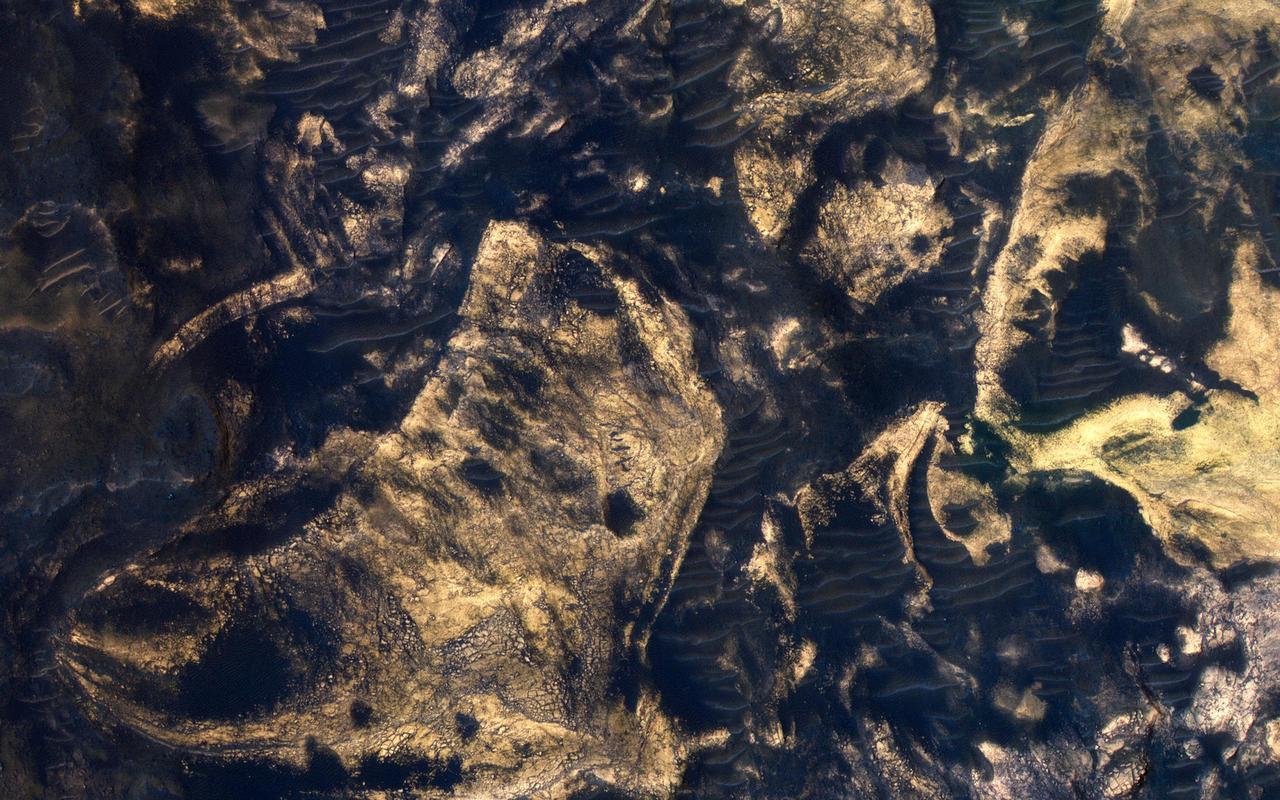
This scene captured by NASA Mars Reconnaissance Orbiter includes chaotic deposits with a wide range of colors. The deposits are distinctive with both unique colors and small-scale textures such as fracture patterns. These are probably sedimentary rocks, transported and deposited in water or air. The original layers may have been jumbled in a landslide. Dark or reddish sand dunes cover some of the bedrock. http://photojournal.jpl.nasa.gov/catalog/PIA19860
In this image from NASA's Mars Reconnaissance Orbiter, layering within the light-toned sulfate deposit is the result of different states of hydration. Some of the layers have sulfates with little water (known as monohydrated sulfates) whereas other layers have higher amounts of water (called polyhydrated sulfates). The different amounts of water within the sulfates may reflect changes in the water chemistry during deposition of the sulfates, or may have occurred after the sulfates were laid down when heat or pressure forced the water out of some layers, causing a decrease in the hydration state. Many locations on Mars have sulfates, which are sedimentary rocks formed in water. Within Valles Marineris, the large canyon system that cuts across the planet, there are big and thick sequences of sulfates. The CRISM instrument on MRO is crucial for telling scientists which type of sulfate is associated with each layer, because each hydration state will produce a spectrum with absorptions at specific wavelengths depending upon the amount of water contained within the sulfate. https://photojournal.jpl.nasa.gov/catalog/PIA21935
This image was acquired to get more information about a site where the CRISM instrument detected hydrated sulfates. The bright materials are likely to be sediments rich in the hydrated sulfates, and this image shows that most of the material is covered by a thin deposit of dark material, perhaps sand. We also see streamlined patterns that suggest fluvial processes were involved in depositing or eroding the sulfate-rich sediments. https://photojournal.jpl.nasa.gov/catalog/PIA26327
This VIS image shows part of the border between Chandor and Melas Chasmata. The entire image is landslide deposits. It is very common for landslides to develop linear surface grooves that parallel the direction of flow. Candor Chasma is one of the largest canyons that make up Valles Marineris. It is approximately 810 km long (503 miles) and has is divided into two regions - eastern and western Candor. Candor is located south of Ophir Chasma and north of Melas Chasma. The border with Melas Chasma contains many large landslide deposits. The floor of Candor Chasma includes a variety of landforms, including layered deposits, dunes, landslide deposits and steep sided cliffs and mesas. Many forms of erosion have shaped Chandor Chasma. There is evidence of wind and water erosion, as well as significant gravity driven mass wasting (landslides). The Odyssey spacecraft has spent over 15 years in orbit around Mars, circling the planet more than 69000 times. It holds the record for longest working spacecraft at Mars. THEMIS, the IR/VIS camera system, has collected data for the entire mission and provides images covering all seasons and lighting conditions. Over the years many features of interest have received repeated imaging, building up a suite of images covering the entire feature. From the deepest chasma to the tallest volcano, individual dunes inside craters and dune fields that encircle the north pole, channels carved by water and lava, and a variety of other feature, THEMIS has imaged them all. For the next several months the image of the day will focus on the Tharsis volcanoes, the various chasmata of Valles Marineris, and the major dunes fields. We hope you enjoy these images! Orbit Number: 17003 Latitude: -8.20616 Longitude: 288.108 Instrument: VIS Captured: 2005-10-14 07:36 https://photojournal.jpl.nasa.gov/catalog/PIA22167
This image shows part of eastern Candor Chasma. At the bottom of the image is the steep cliff between the upper surface elevation and the depths of Candor Chasma. The small lobate feature at the base of the cliff in the bottom of the image is a landslide deposit formed by failure of the cliff face and gravitational downslope movement of the material. Candor Chasma is one of the largest canyons that make up Valles Marineris. It is approximately 810 km long (503 miles) and has is divided into two regions - eastern and western Candor. Candor is located south of Ophir Chasma and north of Melas Chasma. The border with Melas Chasma contains many large landslide deposits. The floor of Candor Chasma includes a variety of landforms, including layered deposits, dunes, landslide deposits and steep sided cliffs and mesas. Many forms of erosion have shaped Chandor Chasma. There is evidence of wind and water erosion, as well as significant gravity driven mass wasting (landslides). The Odyssey spacecraft has spent over 15 years in orbit around Mars, circling the planet more than 69000 times. It holds the record for longest working spacecraft at Mars. THEMIS, the IR/VIS camera system, has collected data for the entire mission and provides images covering all seasons and lighting conditions. Over the years many features of interest have received repeated imaging, building up a suite of images covering the entire feature. From the deepest chasma to the tallest volcano, individual dunes inside craters and dune fields that encircle the north pole, channels carved by water and lava, and a variety of other feature, THEMIS has imaged them all. For the next several months the image of the day will focus on the Tharsis volcanoes, the various chasmata of Valles Marineris, and the major dunes fields. We hope you enjoy these images! Orbit Number: 8916 Latitude: -7.95016 Longitude: 293.509 Instrument: VIS Captured: 2003-12-18 11:38 https://photojournal.jpl.nasa.gov/catalog/PIA22162
Today's VIS image shows a cross section of Coprates Chasma. In this region the chasma has two sections – a deep, flat floored canyon at the top of the image (the northern cliff face is not visible in this image), and the second section below that separated by a large ridge. Paralleling it to the south runs a narrower and shallower chain of linked pits and depressions called Coprates Catena. Landslide deposits, layered materials and sand dunes cover a large portion of the chasma floor. The brighter materials at the top of the image are layered deposits. It is unknown how deep these canyon deposits were when they formed. The layering is only visible due to erosion, making it difficult to estimate the original thickness. While layered deposits can be found on the floor of Coprates Chasma, they are most commonly found along the lower elevations and at the bottom of the cliff faces in the canyon. Coprates Chasma is one of the numerous canyons that make up Valles Marineris. The chasma stretches for 960 km (600 miles) from Melas Chasma to the west and Capri Chasma to the east. Orbit Number: 93111 Latitude: -14.0758 Longitude: 295.079 Instrument: VIS Captured: 2022-12-11 00:40 https://photojournal.jpl.nasa.gov/catalog/PIA25816
The bottom half of this image of central Candor Chasma shows a surface topography called chaos. Chaos is a region of small to medium sized mesas surrounded by valleys that are usually the same elevation. In this image sand and sand dunes are accumulating in the valleys and increasing in depth. Candor Chasma is one of the largest canyons that make up Valles Marineris. It is approximately 810 km long (503 miles) and has is divided into two regions - eastern and western Candor. Candor is located south of Ophir Chasma and north of Melas Chasma. The border with Melas Chasma contains many large landslide deposits. The floor of Candor Chasma includes a variety of landforms, including layered deposits, dunes, landslide deposits and steep sided cliffs and mesas. Many forms of erosion have shaped Chandor Chasma. There is evidence of wind and water erosion, as well as significant gravity driven mass wasting (landslides). The Odyssey spacecraft has spent over 15 years in orbit around Mars, circling the planet more than 69000 times. It holds the record for longest working spacecraft at Mars. THEMIS, the IR/VIS camera system, has collected data for the entire mission and provides images covering all seasons and lighting conditions. Over the years many features of interest have received repeated imaging, building up a suite of images covering the entire feature. From the deepest chasma to the tallest volcano, individual dunes inside craters and dune fields that encircle the north pole, channels carved by water and lava, and a variety of other feature, THEMIS has imaged them all. For the next several months the image of the day will focus on the Tharsis volcanoes, the various chasmata of Valles Marineris, and the major dunes fields. We hope you enjoy these images! Orbit Number: 18251 Latitude: -6.45589 Longitude: 287.35 Instrument: VIS Captured: 2006-01-25 01:39 https://photojournal.jpl.nasa.gov/catalog/PIA22168
This image of central Candor Chasma shows a surface topography called chaos. Chaos is a region of small to medium sized mesas surrounded by valleys that are usually the same elevation. In this image sand and sand dunes have accumulated in the valleys near the top of the image, but are not as prevalent towards the bottom of the image. Candor Chasma is one of the largest canyons that make up Valles Marineris. It is approximately 810 km long (503 miles) and has is divided into two regions - eastern and western Candor. Candor is located south of Ophir Chasma and north of Melas Chasma. The border with Melas Chasma contains many large landslide deposits. The floor of Candor Chasma includes a variety of landforms, including layered deposits, dunes, landslide deposits and steep sided cliffs and mesas. Many forms of erosion have shaped Chandor Chasma. There is evidence of wind and water erosion, as well as significant gravity driven mass wasting (landslides). The Odyssey spacecraft has spent over 15 years in orbit around Mars, circling the planet more than 69000 times. It holds the record for longest working spacecraft at Mars. THEMIS, the IR/VIS camera system, has collected data for the entire mission and provides images covering all seasons and lighting conditions. Over the years many features of interest have received repeated imaging, building up a suite of images covering the entire feature. From the deepest chasma to the tallest volcano, individual dunes inside craters and dune fields that encircle the north pole, channels carved by water and lava, and a variety of other feature, THEMIS has imaged them all. For the next several months the image of the day will focus on the Tharsis volcanoes, the various chasmata of Valles Marineris, and the major dunes fields. We hope you enjoy these images! Orbit Number: 26213 Latitude: -7.25478 Longitude: 287.032 Instrument: VIS Captured: 2007-11-11 14:48 https://photojournal.jpl.nasa.gov/catalog/PIA22169
This THEMIS image shows part of western Candor Chasma. Near the bottom of the image is an impact crater. Impact craters are relatively rare within all the canyons of Valles Marineris. The lack of craters may be due to the relative young age of the canyon system - younger surfaces on Mars have fewer craters than older surfaces. Another factor is that the high rate of erosion and deposition within the canyon erodes the ejecta blanket and fills in the crater, effectively removing the crater over time. Candor Chasma is one of the largest canyons that make up Valles Marineris. It is approximately 810 km long (503 miles) and has is divided into two regions - eastern and western Candor. Candor is located south of Ophir Chasma and north of Melas Chasma. The border with Melas Chasma contains many large landslide deposits. The floor of Candor Chasma includes a variety of landforms, including layered deposits, dunes, landslide deposits and steep sided cliffs and mesas. Many forms of erosion have shaped Chandor Chasma. There is evidence of wind and water erosion, as well as significant gravity driven mass wasting (landslides). The Odyssey spacecraft has spent over 15 years in orbit around Mars, circling the planet more than 69000 times. It holds the record for longest working spacecraft at Mars. THEMIS, the IR/VIS camera system, has collected data for the entire mission and provides images covering all seasons and lighting conditions. Over the years many features of interest have received repeated imaging, building up a suite of images covering the entire feature. From the deepest chasma to the tallest volcano, individual dunes inside craters and dune fields that encircle the north pole, channels carved by water and lava, and a variety of other feature, THEMIS has imaged them all. For the next several months the image of the day will focus on the Tharsis volcanoes, the various chasmata of Valles Marineris, and the major dunes fields. We hope you enjoy these images! Orbit Number: 16479 Latitude: -5.02282 Longitude: 284.268 Instrument: VIS Captured: 2005-09-01 04:09 https://photojournal.jpl.nasa.gov/catalog/PIA22166
Candor Chasma is one of the largest canyons that make up Valles Marineris. It is approximately 810 km long (503 miles) and has is divided into two regions - eastern and western Candor. Candor is located south of Ophir Chasma and north of Melas Chasma. The border with Melas Chasma contains many large landslide deposits. The floor of Candor Chasma includes a variety of landforms, including layered deposits, dunes, landslide deposits and steep sided cliffs and mesas. Many forms of erosion have shaped Chandor Chasma. There is evidence of wind and water erosion, as well as significant gravity driven mass wasting (landslides). This image shows part of western Candor and the erosion of a large mesa. Layered materials are visible throughout the image and small dunes exist in several places. The Odyssey spacecraft has spent over 15 years in orbit around Mars, circling the planet more than 69000 times. It holds the record for longest working spacecraft at Mars. THEMIS, the IR/VIS camera system, has collected data for the entire mission and provides images covering all seasons and lighting conditions. Over the years many features of interest have received repeated imaging, building up a suite of images covering the entire feature. From the deepest chasma to the tallest volcano, individual dunes inside craters and dune fields that encircle the north pole, channels carved by water and lava, and a variety of other feature, THEMIS has imaged them all. For the next several months the image of the day will focus on the Tharsis volcanoes, the various chasmata of Valles Marineris, and the major dunes fields. We hope you enjoy these images! Orbit Number: 4360 Latitude: -6.08522 Longitude: 284.85 Instrument: VIS Captured: 2002-12-08 10:51 https://photojournal.jpl.nasa.gov/catalog/PIA22160
This image shows part of western Candor and the erosion of a large mesa. Layered materials are visible throughout the image. The dark material with the linear appearance in the middle of the image are sand dunes. Sand dunes are created by wind action. At the present time, wind is the active process shaping the surface. Candor Chasma is one of the largest canyons that make up Valles Marineris. It is approximately 810 km long (503 miles) and has is divided into two regions - eastern and western Candor. Candor is located south of Ophir Chasma and north of Melas Chasma. The border with Melas Chasma contains many large landslide deposits. The floor of Candor Chasma includes a variety of landforms, including layered deposits, dunes, landslide deposits and steep sided cliffs and mesas. Many forms of erosion have shaped Chandor Chasma. There is evidence of wind and water erosion, as well as significant gravity driven mass wasting (landslides). The Odyssey spacecraft has spent over 15 years in orbit around Mars, circling the planet more than 69000 times. It holds the record for longest working spacecraft at Mars. THEMIS, the IR/VIS camera system, has collected data for the entire mission and provides images covering all seasons and lighting conditions. Over the years many features of interest have received repeated imaging, building up a suite of images covering the entire feature. From the deepest chasma to the tallest volcano, individual dunes inside craters and dune fields that encircle the north pole, channels carved by water and lava, and a variety of other feature, THEMIS has imaged them all. For the next several months the image of the day will focus on the Tharsis volcanoes, the various chasmata of Valles Marineris, and the major dunes fields. We hope you enjoy these images! Orbit Number: 6245 Latitude: -5.77639 Longitude: 284.339 Instrument: VIS Captured: 2003-05-12 14:49 https://photojournal.jpl.nasa.gov/catalog/PIA22161
This image shows part of eastern Candor Chasma. In the middle of the image is a set of linear ridges and valleys. These features are called yardangs and are created by uniform winds that winnow away materials. Once the valleys are formed the wind then is funneled through the valley and erosion continues more in the valley than on the ridges. At the bottom of the valleys there are sand materials covering the slope between the valleys and the surrounding chasma floor. Beyond this coating of sand there are darker sand deposits where wind has accumulated the sand into larger dunes. The brighter mesa on the right side of the image has also been wind eroded into yardangs, but are aligned in a different direction than the larger yardangs. This indicates that wind directions within the canyon have changed over time. Candor Chasma is one of the largest canyons that make up Valles Marineris. It is approximately 810 km long (503 miles) and has is divided into two regions - eastern and western Candor. Candor is located south of Ophir Chasma and north of Melas Chasma. The border with Melas Chasma contains many large landslide deposits. The floor of Candor Chasma includes a variety of landforms, including layered deposits, dunes, landslide deposits and steep sided cliffs and mesas. Many forms of erosion have shaped Chandor Chasma. There is evidence of wind and water erosion, as well as significant gravity driven mass wasting (landslides). The Odyssey spacecraft has spent over 15 years in orbit around Mars, circling the planet more than 69000 times. It holds the record for longest working spacecraft at Mars. THEMIS, the IR/VIS camera system, has collected data for the entire mission and provides images covering all seasons and lighting conditions. Over the years many features of interest have received repeated imaging, building up a suite of images covering the entire feature. From the deepest chasma to the tallest volcano, individual dunes inside craters and dune fields that encircle the north pole, channels carved by water and lava, and a variety of other feature, THEMIS has imaged them all. For the next several months the image of the day will focus on the Tharsis volcanoes, the various chasmata of Valles Marineris, and the major dunes fields. We hope you enjoy these images! Orbit Number: 10551 Latitude: -6.93639 Longitude: 288.562 Instrument: VIS Captured: 2004-05-01 02:24 https://photojournal.jpl.nasa.gov/catalog/PIA22165