
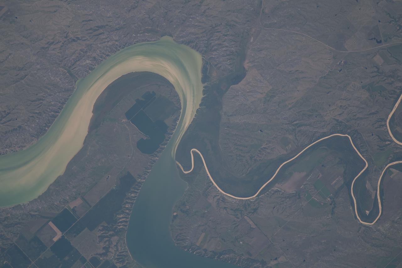
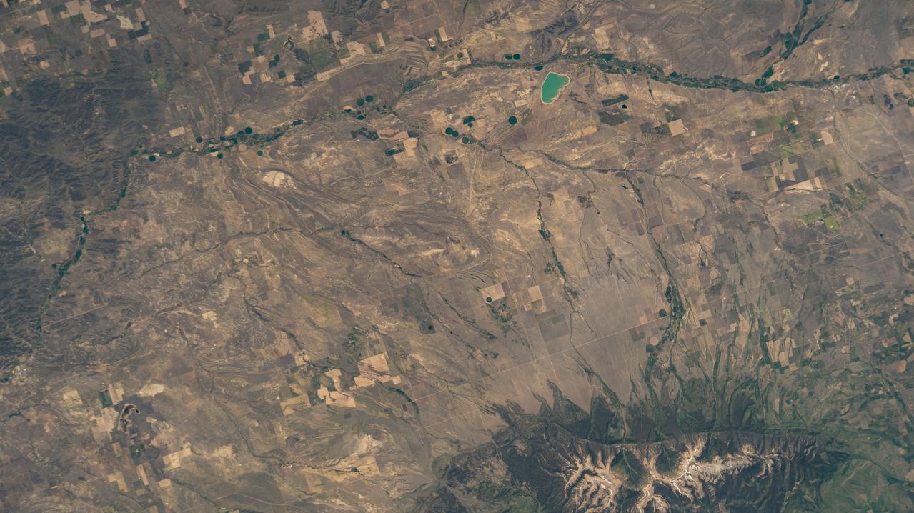
An astonishing diversity of geological features, ecological systems and human landscapes across North America is indicated within this image from NASA Terra spacecraft.
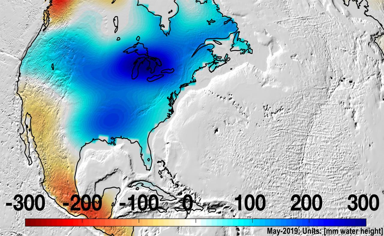
North America was almost entirely above its long-term average in mass in May 2019, due to Midwestern flooding, with the runoff raising the Great Lakes to record levels. https://photojournal.jpl.nasa.gov/catalog/PIA22840
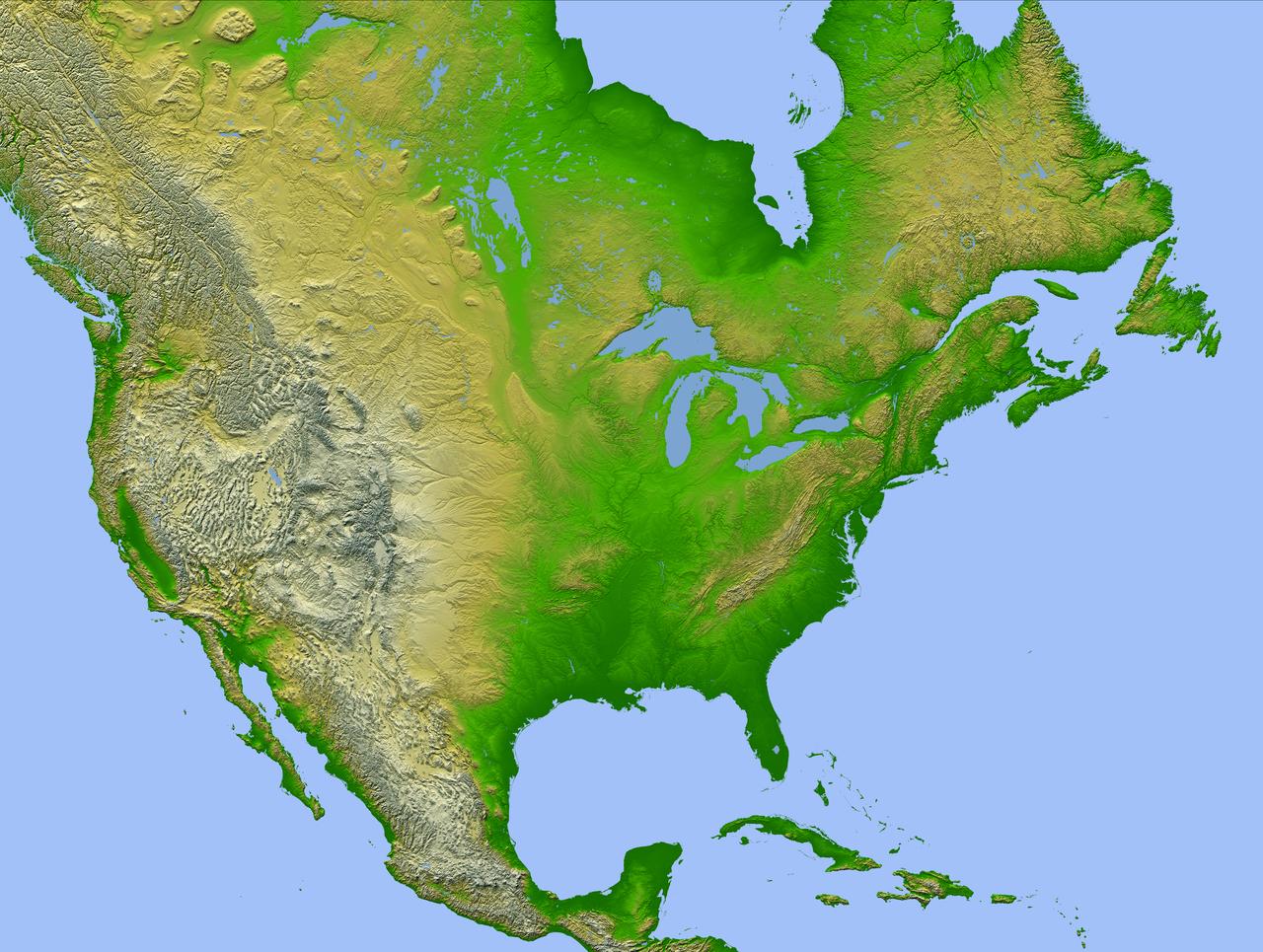
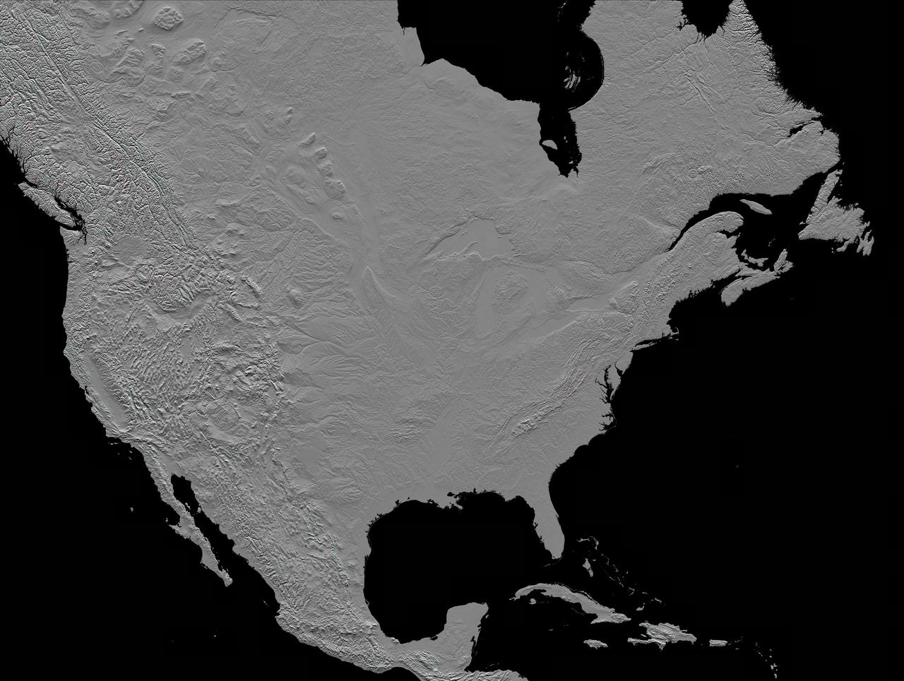
This image of North America was generated with data from NASA Shuttle Radar Topography Mission SRTM.
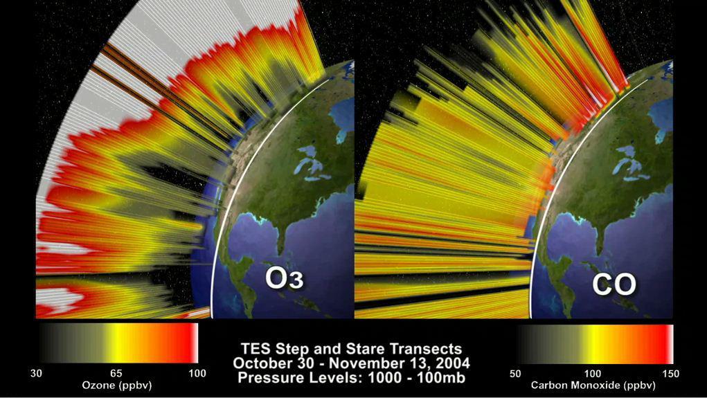
This frame from an animation depicts the distribution of O3 and CO in the atmosphere over North America. This visualization is based on data acquired by NASA Tropospheric Emission Spectrometer TES.

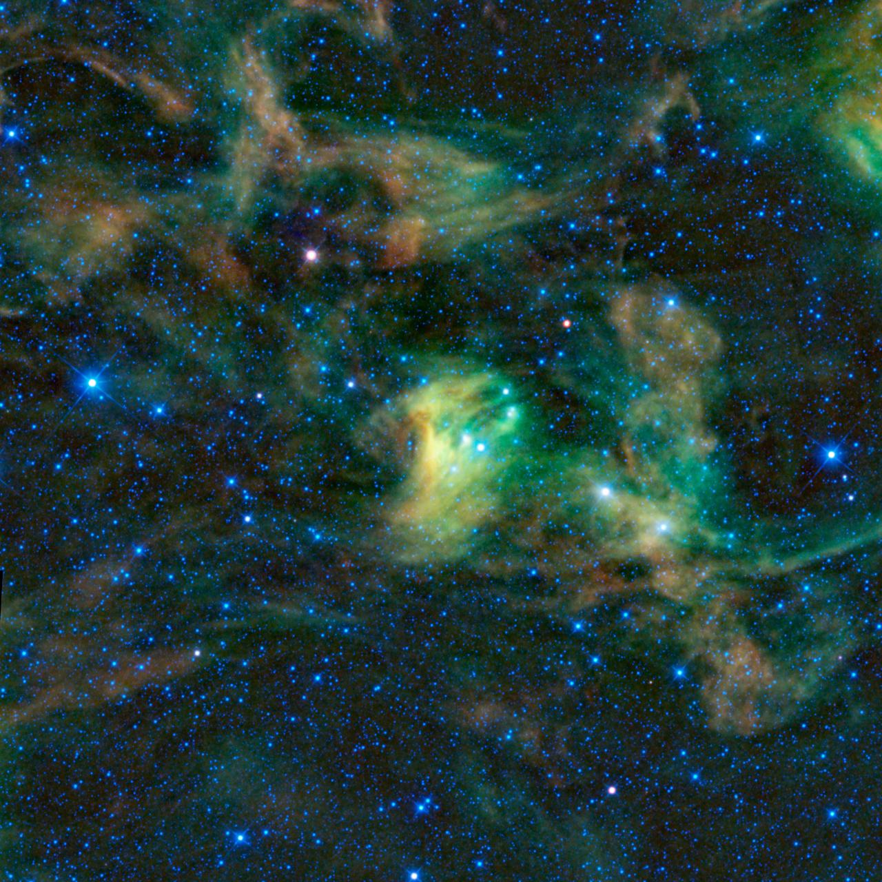
This view of the North America nebula combines both visible and infrared light observations, taken by the Digitized Sky Survey and NASA Spitzer Space Telescope. Clusters of young stars about one million years old can be found throughout the image.
Overnight on October 4-5, 2012, a mass of energetic particles from the atmosphere of the Sun were flung out into space, a phenomenon known as a coronal mass ejection. Three days later, the storm from the Sun stirred up the magnetic field around Earth and produced gorgeous displays of northern lights. NASA satellites track such storms from their origin to their crossing of interplanetary space to their arrival in the atmosphere of Earth. Using the “day-night band” (DNB) of the Visible Infrared Imaging Radiometer Suite (VIIRS), the Suomi National Polar-orbiting Partnership (Suomi NPP) satellite acquired this view of the aurora borealis early on the morning of October 8, 2012. The northern lights stretch across Canada’s Quebec and Ontario provinces in the image, and are part of the auroral oval that expanded to middle latitudes because of a geomagnetic storm. The DNB sensor detects dim light signals such as auroras, airglow, gas flares, city lights, and reflected moonlight. In the case of the image above, the sensor detected the visible light emissions as energetic particles rained down from Earth’s magnetosphere and into the gases of the upper atmosphere. The images are similar to those collected by the Operational Linescan System flown on U.S. Defense Meteorological Satellite Program (DMSP) satellites for the past three decades. “When I first saw images like this as a graduate student, I was immediately struck by the fluid dynamic characteristics of the aurora,” said Tom Moore, a space physicist at NASA's Goddard Space Flight Center. “Viewing the aurora in this way makes it immediately clear that space weather is an interaction of fluids from the Sun with those of the Earth's upper atmosphere. The electrodynamics make for important differences between plasmas and ordinary fluids, but familiar behaviors (for example, waves and vortices) are still very apparent. It makes me wonder at the ability of apparently empty space to behave like a fluid.” Auroras typically occur when solar flares and coronal mass ejections—or even an active solar wind stream—disturb and distort the magnetosphere, the cocoon of space protected by Earth’s magnetic field. The collision of solar particles and pressure into our planet’s magnetosphere accelerates particles trapped in the space around Earth (such as in the radiation belts). Those particles are sent crashing down into Earth’s upper atmosphere—at altitudes of 100 to 400 kilometers (60 to 250 miles)—where they excite oxygen and nitrogen molecules and release photons of light. The results are rays, sheets, and curtains of dancing light in the sky. Auroras are a beautiful expression of the connection between Sun and Earth, but not all of the connections are benign. Auroras are connected to geomagnetic storms, which can distort radio communications (particularly high frequencies), disrupt electric power systems on the ground, and give slight but detectable doses of radiation to flight crews and passengers on high-latitude airplane flights and on spacecraft. The advantage of images like those from VIIRS and DMSP is resolution, according to space physicist Patrick Newell of the Johns Hopkins University Applied Physics Laboratory. “You can see very fine detail in the aurora because of the low altitude and the high resolution of the camera,” he said. Most aurora scientists prefer to use images from missions dedicated to aurora studies (such as Polar, IMAGE, and ground-based imagers), which can offer many more images of a storm (rather than one per orbit) and can allow researchers to calculate the energy moving through the atmosphere. There are no science satellites flying right now that provide such a view, though astronauts regularly photograph and film auroras from the International Space Station. NASA Earth Observatory image by Jesse Allen and Robert Simmon, using VIIRS Day-Night Band data from the Suomi National Polar-orbiting Partnership (Suomi NPP) and the University of Wisconsin's Community Satellite Processing Package. Suomi NPP is the result of a partnership between NASA, the National Oceanic and Atmospheric Administration, and the Department of Defense. Caption by Mike Carlowicz. Instrument: Suomi NPP - VIIRS Credit: <b><a href="http://www.earthobservatory.nasa.gov/" rel="nofollow"> NASA Earth Observatory</a></b> <b><a href="http://www.nasa.gov/audience/formedia/features/MP_Photo_Guidelines.html" rel="nofollow">NASA image use policy.</a></b> <b><a href="http://www.nasa.gov/centers/goddard/home/index.html" rel="nofollow">NASA Goddard Space Flight Center</a></b> enables NASA’s mission through four scientific endeavors: Earth Science, Heliophysics, Solar System Exploration, and Astrophysics. Goddard plays a leading role in NASA’s accomplishments by contributing compelling scientific knowledge to advance the Agency’s mission. <b>Follow us on <a href="http://twitter.com/NASA_GoddardPix" rel="nofollow">Twitter</a></b> <b>Like us on <a href="http://www.facebook.com/pages/Greenbelt-MD/NASA-Goddard/395013845897?ref=tsd" rel="nofollow">Facebook</a></b> <b>Find us on <a href="http://instagrid.me/nasagoddard/?vm=grid" rel="nofollow">Instagram</a></b>

Using the “day-night band” (DNB) of the Visible Infrared Imaging Radiometer Suite (VIIRS), the Suomi National Polar-orbiting Partnership (Suomi NPP) satellite acquired this view of the aurora borealis on March 18, 2015. The northern lights stretch across Canada’s Quebec, Ontario, Manitoba, Nunavut, and Newfoundland provinces in the image, and are part of the auroral oval that expanded to middle latitudes because of a geomagnetic storm on March 17, 2015. The DNB sensor detects dim light signals such as auroras, airglow, gas flares, city lights, and reflected moonlight. In the case of the image above, the sensor detected the visible light emissions as energetic particles rained down from Earth’s magnetosphere and into the gases of the upper atmosphere. The images are similar to those collected by the Operational Linescan System flown on U.S. Defense Meteorological Satellite Program (DMSP) satellites for the past three decades. Auroras typically occur when solar flares and coronal mass ejections—or even an active solar wind stream—disturb and distort the magnetosphere, the cocoon of space protected by Earth’s magnetic field. The collision of solar particles and pressure into our planet’s magnetosphere accelerates particles trapped in the space around Earth (such as in the radiation belts). Those particles are sent crashing down into Earth’s upper atmosphere—at altitudes of 100 to 400 kilometers (60 to 250 miles)—where they excite oxygen and nitrogen molecules and release photons of light. The results are rays, sheets, and curtains of dancing light in the sky. Read more: <a href="http://earthobservatory.nasa.gov/NaturalHazards/view.php?id=85556&eocn=home&eoci=nh" rel="nofollow">earthobservatory.nasa.gov/NaturalHazards/view.php?id=8555...</a> NASA Earth Observatory image by Jesse Allen, using VIIRS day-night band data from the Suomi National Polar-orbiting Partnership. Suomi NPP is the result of a partnership between NASA, the National Oceanic and Atmospheric Administration, and the Department of Defense. Caption by Mike Carlowicz and Adam Voiland. Credit: <b><a href="http://www.earthobservatory.nasa.gov/" rel="nofollow"> NASA Earth Observatory</a></b> <b><a href="http://www.nasa.gov/audience/formedia/features/MP_Photo_Guidelines.html" rel="nofollow">NASA image use policy.</a></b> <b><a href="http://www.nasa.gov/centers/goddard/home/index.html" rel="nofollow">NASA Goddard Space Flight Center</a></b> enables NASA’s mission through four scientific endeavors: Earth Science, Heliophysics, Solar System Exploration, and Astrophysics. Goddard plays a leading role in NASA’s accomplishments by contributing compelling scientific knowledge to advance the Agency’s mission. <b>Follow us on <a href="http://twitter.com/NASAGoddardPix" rel="nofollow">Twitter</a></b> <b>Like us on <a href="http://www.facebook.com/pages/Greenbelt-MD/NASA-Goddard/395013845897?ref=tsd" rel="nofollow">Facebook</a></b> <b>Find us on <a href="http://instagrid.me/nasagoddard/?vm=grid" rel="nofollow">Instagram</a></b>
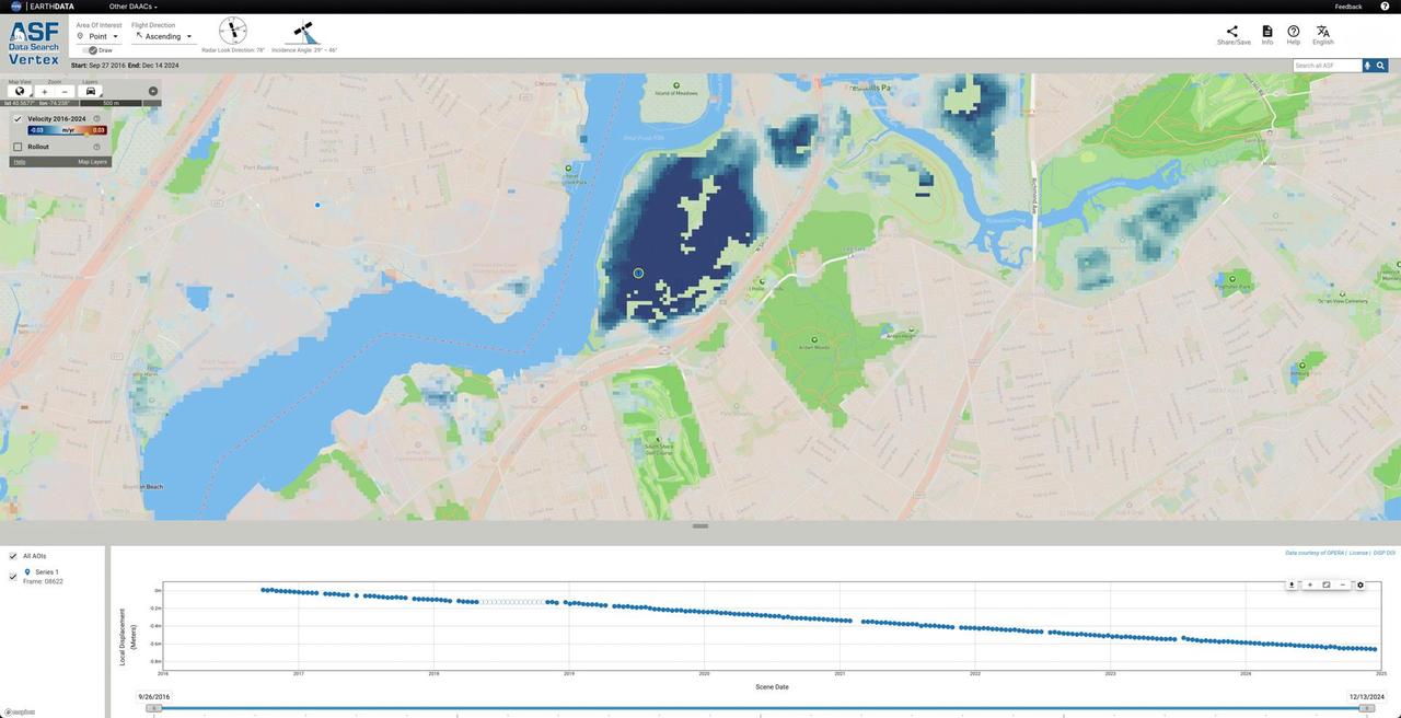
NASA, along with the agency's Jet Propulsion Laboratory in Southern California, is collaborating with the Alaska Satellite Facility in Fairbanks to create a powerful web-based tool that will show the movement of land across North America down to less than an inch. The online portal and its underlying dataset unlock a trove of satellite radar measurements that can help anyone identify where and by how much the land beneath their feet may be moving – whether from earthquakes, volcanoes, landslides, or the extraction of underground natural resources such as groundwater. Spearheaded by NASA's Observational Products for End-Users from Remote Sensing Analysis, or OPERA, project at JPL, the effort equips users with information that would otherwise take years of training to harness. The project builds on data from spaceborne synthetic aperture radars, or SARs, to generate high-resolution data on how Earth's surface is moving. Formally called the North America Surface Displacement Product Suite, the new dataset dates to 2016. By the end of 2025, the data will cover the entire United States, Central America, and Canada within 120 miles (200 kilometers) of the U.S. border. The image shows how the portal visualizes land sinking over time in Freshkills Park, which is being built on a former landfill on Staten Island, New York. Landfills tend to sink over time as waste decomposes, compacts, and settles under its own weight. The blue dot marks the point on the land where the portal is displaying movement in the accompanying scatterplot. https://photojournal.jpl.nasa.gov/catalog/PIA26494
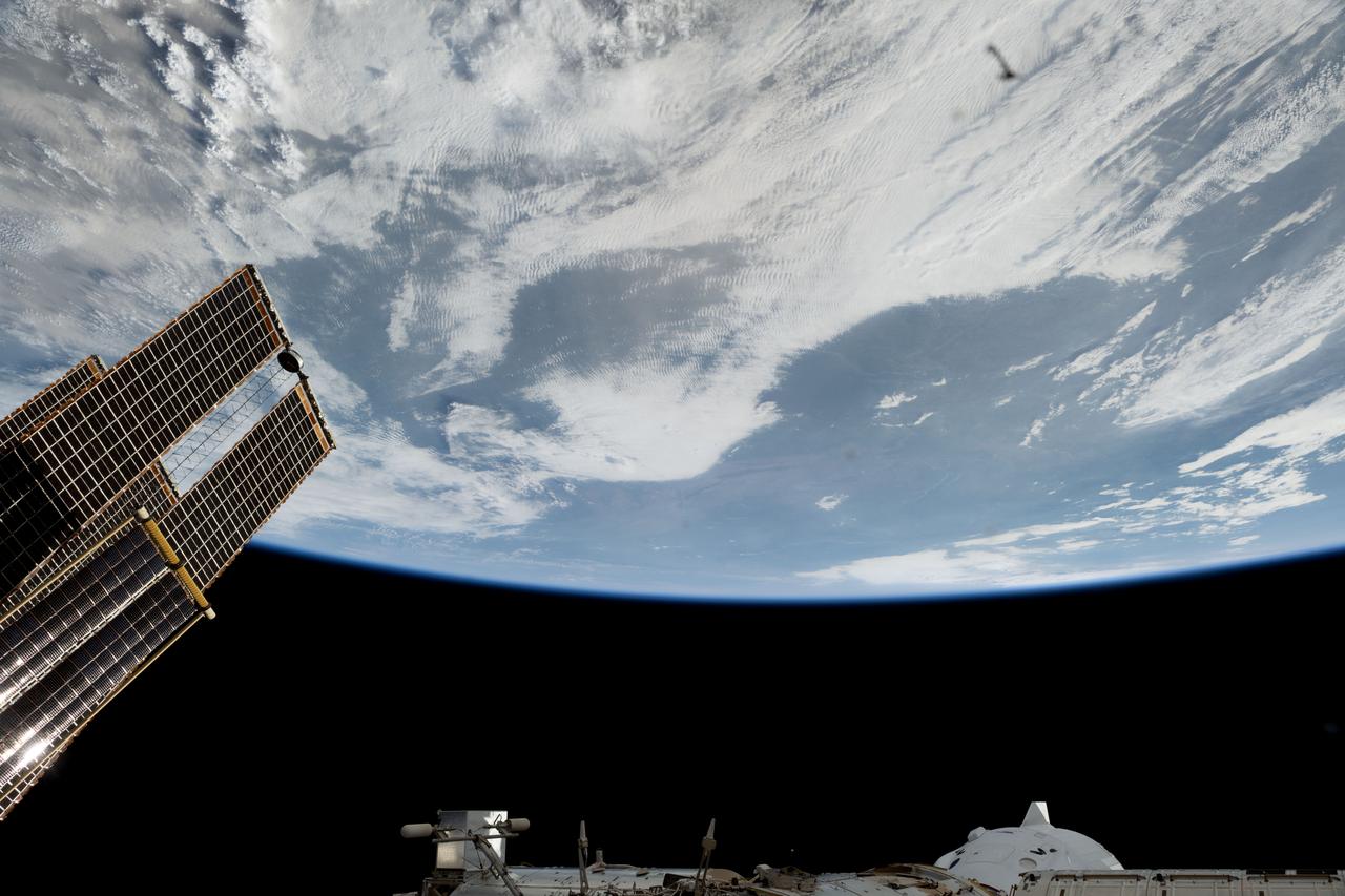
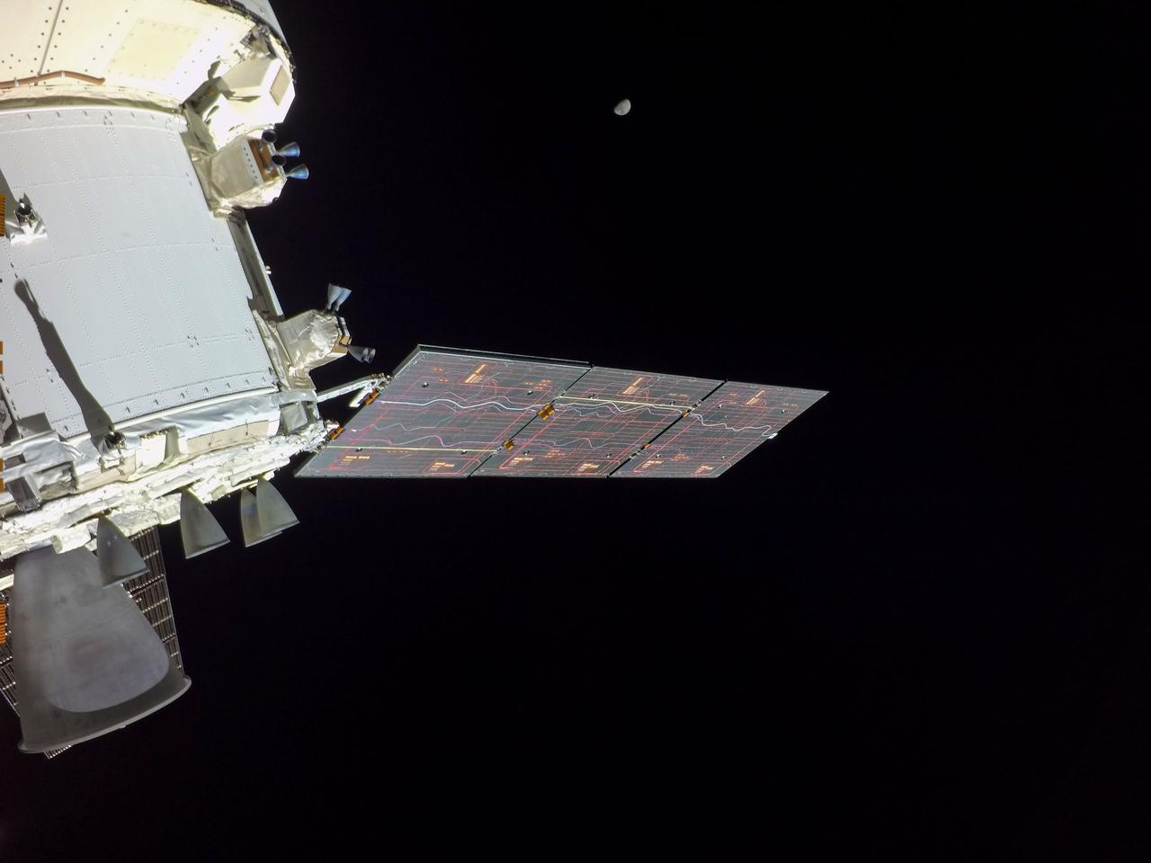
iss073e0044592 (April 28, 2025) --- Partially obscured, at bottom right, is the SpaceX Dragon crew spacecraft docked to the Harmony module's forward port on the International Space Station. At left, are a set of the orbital outpost's main solar arrays and rollout solar arrays. The space station was orbiting 262 miles above a cloudy North America at the time of this photograph.

S62-06606 (3 Oct. 1962) --- Cloud formation over Western Atlantic Ocean north of South America taken during the fourth orbit pass of the Mercury-Atlas 8 (MA-8) mission by astronaut Walter M. Schirra Jr. with a hand-held camera. Photo credit: NASA
iss073e0088323 (May 16, 2025) --- City lights dot the Pacific Northwest region of North America at approximately 2:50 a.m. local time in this photograph from the International Space Station as it orbited 261 miles above the Pacific Ocean. In the lower right foreground, is a set of the orbital outpost's main solar arrays.
Death Valley, Calif., has the lowest point in North America, Badwater at 85.5 meters 282 feet below sea level. It is also the driest and hottest location in North America. This image is from NASA Terra spacecraft.
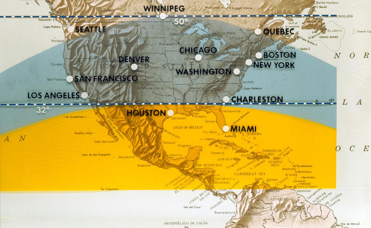
S70-06463 (June 1970) --- This map of North America has been marked to indicate areas of photographic imagery available from Apollo photography (32-degree orbits) as opposed to that imagery which will be available from a 50-degree inclined orbit. The region between the two broken lines will be in the area that can be covered by the first manned Skylab mission in 1973. Photo credit: NASA
iss073e0982431 (Oct. 25, 2025) --- A yellow-green airglow, caused by atoms and molecules releasing energy as light after being excited by ultraviolet sunlight or cosmic rays, blankets the city lights of North America in this photograph, taken at approximately 2:18 a.m. local time from the International Space Station as it orbited 260 miles above Texas.
This image from NASA Terra satellite shows the Morenci open-pit copper mine in southeast Arizona, North America leading producer of copper.
This anaglyph, from NASA Shuttle Radar Topography Mission, is of the Iturralde Structure, Bolivia, a possible impact crater. 3D glasses are necessary to view this image.
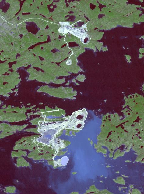
This image from NASA Terra spacecraft shows the Diavik Mine in northern Canada.The largest diamond found in North America came from the Diavik Mine. The Foxfire diamond weighs an impressive 187 carats, and was discovered in August 2015; it has been displayed in several museums throughout North America. The Diavik mine is located on an island in Lac de Gras, within the Lac de Gras kimberlite field, among other diamond mines. The image was acquired September 23, 2016, covers an area of 13.8 by 19.4 km, and is located at 64.5 degrees north, 110.2 degrees west. https://photojournal.jpl.nasa.gov/catalog/PIA21536
Between the claws of the dreaded scorpion imagined by the ancient Greeks lies this giant dust cloud, imaged by the Wide-field Infrared Survey Explorer. The constellation of Scorpius is prominent in the summer night sky in North America.
The 1,200-kilometer 800-mile San Andreas is the longest fault in California and one of the longest in North America as seen by NASA Shuttle Radar Topography Mission SRTM on February 16, 2000.

This infrared image from NASA Spitzer Space Telescope shows a swirling landscape of stars known as the North America nebula. Clusters of young stars about one million years old can be found throughout the image.

The Mackenzie River in the Northwest Territories, Canada, with its headstreams the Peace and Finley, is the longest river in North America. This image was acquired by NASA Terra satellite on August 4, 2005.
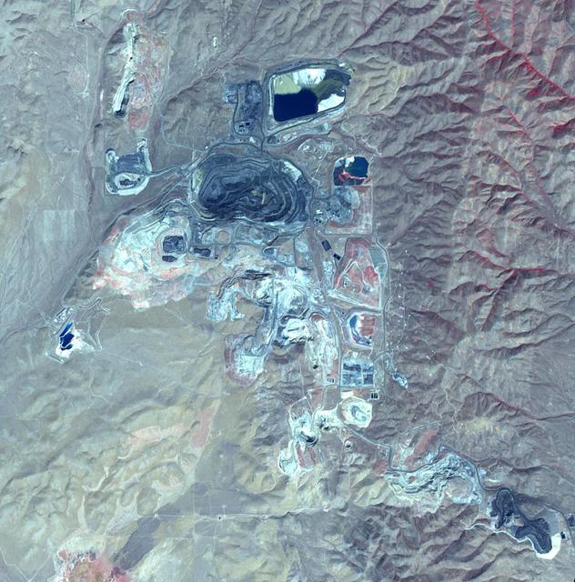
This image from NASA Terra spacecraft shows Goldstrike in northeast Nevada, the largest gold mine in North America. The mine complex, (including the Betze-Post-Screamer open-pit, and Meikle and Rodeo underground mines) is owned and operated by the world's largest gold mining company, Barrick Gold. Gold occurs as microscopically fine grains, with an average grade of 0.1 ounces per ton of ore. Estimates of reserves are as high as 35 million ounces of gold. The image was acquired September 25, 2010, covers an area of 15 by 15 km, and is located at 41 degrees north, 116.4 degrees west. https://photojournal.jpl.nasa.gov/catalog/PIA21665
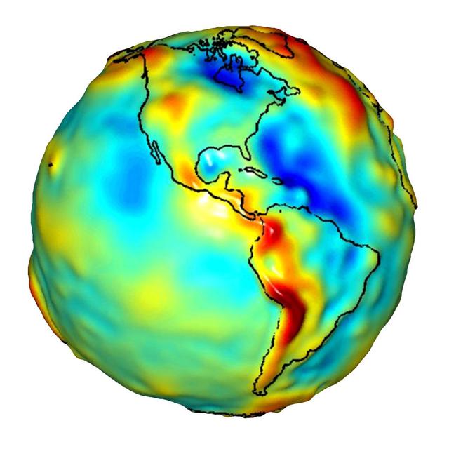
This visualization of a gravity model was created with data from NASA Gravity Recovery and Climate Experiment and shows variations in the gravity field across the Americas.

Senior executives from the Renault-Nissan Alliance, including Carlos Ghosn, chairman and CEO of Nissan, and Jose Munoz, chairman of Nissan North America, visited Ames for meetings with center management and a showcase of the technical partnership between NASA and Nissan North America.
iss062e137200 (April 6, 2020) --- A waxing gibbous Moon is pictured from the International Space Station as it orbited above North America.

iss062e137195 (April 6, 2020) --- A waxing gibbous Moon is pictured from the International Space Station as it orbited above North America.

iss070e062746 (Jan. 10, 2024) --- The city lights of North America appear under Earth's airglow and a starry night sky in this photograph from the International Space Station as it orbited 262 miles above North Dakota.
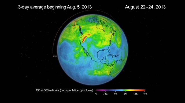
This frame from a movie was produced with data from NASA Aqua spacecraft showing the spread of carbon monoxide pollution across North America from fires in the Western U.S., including the Beaver Creek Fire in Idaho and the Rim Fire in California.

This visible light/infrared image from NASA Spitzer Space Telescope shows a swirling landscape of stars known as the North America nebula. Clusters of young stars about one million years old can be found throughout the image.
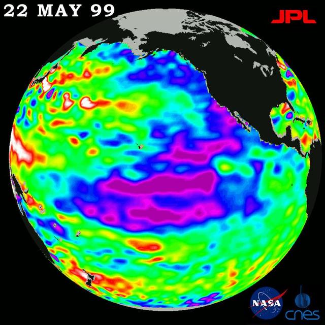
New sea surface height measurements from NASA TOPEX/Poseidon satellite show that the sea level and temperature of the entire Pacific is out of balance, including a large area of abnormally cool water along the west coast of North America.
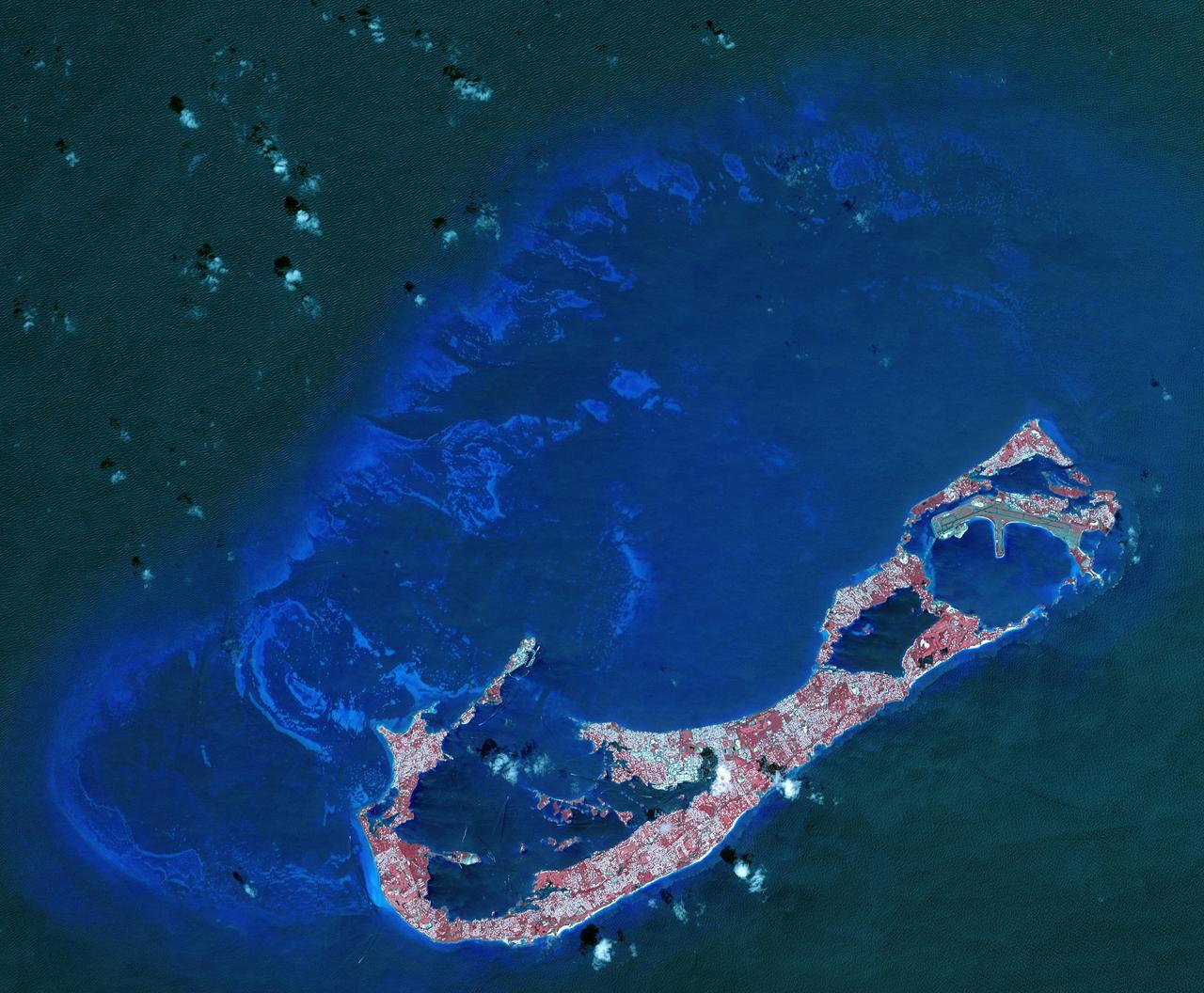
Bermuda is a British Overseas Territory in the western Atlantic off the east coast of North America. The uninhabited islands were first discovered in 1503 by the Spanish explorer Juan de Bermudez. In 1609 the English Virginia Colony settled Bermuda, and it has remained a British colony for over 400 years. Bermuda's economy is dominated by offshore insurance, and tourism, resulting in a very high GDP per capita. The image was acquired April 19, 2009, covers an area of 29.4 by 40.7 kilometers, and is located at 32.3 degrees north, 64.8 degrees west. http://photojournal.jpl.nasa.gov/catalog/PIA21315
iss061e006776 (Oct. 16, 2019) --- McDonald Lake in Saskatchewan, Canada, is pictured as the International Space Station orbited 254 miles above North America. The coal-mining city of Estevan, at the lake's southeast end surrounded by prairies and farms, is 10 miles north of the United States border of North Dakota.

Under mostly overcast skies, the Moon passes in front of the Sun as a partial solar eclipse approaches 85% in New Orleans, home of NASA’s Michoud Assembly Facility, on Monday, April 8, 2024. A total solar eclipse tracked along a narrow strip of the North American continent from Mexico’s Pacific coast to the Atlantic coast of Newfoundland, Canada. A partial solar eclipse was visible across the entire North American continent as well as parts of Europe and Central America. Image credit: NASA/Michael DeMocker

Under mostly overcast skies, the Moon passes in front of the Sun as a partial solar eclipse approaches 85% in New Orleans, home of NASA’s Michoud Assembly Facility, on Monday, April 8, 2024. A total solar eclipse tracked along a narrow strip of the North American continent from Mexico’s Pacific coast to the Atlantic coast of Newfoundland, Canada. A partial solar eclipse was visible across the entire North American continent as well as parts of Europe and Central America. Image credit: NASA/Michael DeMocker

iss061e111794 (Jan. 1, 2020) --- Winnipeg, in the Canadian province of Manitoba, is photographed in this nighttime shot as the International Space Station orbited 261 miles above North America.
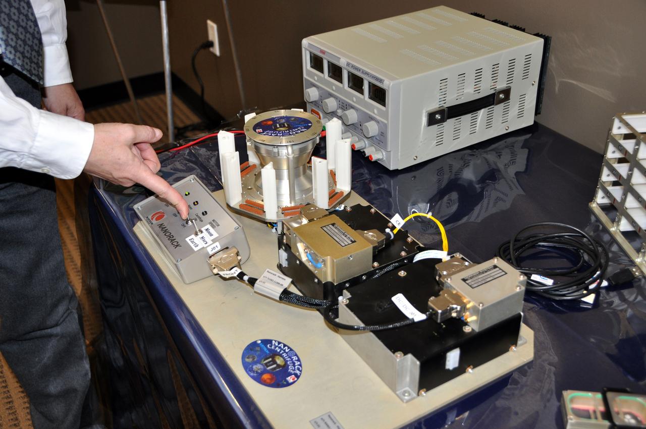
JSC2012-E-029873 (14 Feb. 2012) --- This is a medium close-up view of a gravitational research centrifuge which Astrium Space Transportation handed over to NanoRacks LLC, during a ceremony on Feb. 14 at Astrium North America?s Houston facility. Astrium ST and NanoRacks are working in cooperation with NASA to deliver the commercial centrifuge facility to the International Space Station. NASA Photo courtesy Astrium North America

Senior executives from the Renault-Nissan Alliance, including Carlos Ghosn, chairman and CEO of Nissan, and Jose Munoz, chairman of Nissan North America, visited Ames for meetings and a showcase of the technical partnership between NASA and Nissan North America. After briefings, the group observed testing of Nissan’s all-electric LEAF as it performed safe autonomous drives across the center.

Senior executives from the Renault-Nissan Alliance, including Carlos Ghosn, chairman and CEO of Nissan, and Jose Munoz, chairman of Nissan North America, visited Ames for meetings and a showcase of the technical partnership between NASA and Nissan North America. Shown here on left is Eugene Tu, Ames Center Director on right is Carlos Ghosn, CEO, Nissan

Senior executives from the Renault-Nissan Alliance, including Carlos Ghosn, chairman and CEO of Nissan, and Jose Munoz, chairman of Nissan North America, visited Ames for meetings and a showcase of the technical partnership between NASA and Nissan North America. Shown here on left is Carlos Ghosn, CEO, Nissan on right Eugene Tu, Ames Center Director in front to the NASA sign at the VMS Facility at Ames Research Center ,CA.

Senior executives from the Renault-Nissan Alliance, including Carlos Ghosn, chairman and CEO of Nissan, and Jose Munoz, chairman of Nissan North America, visited Ames for meetings and a showcase of the technical partnership between NASA and Nissan North America. After briefings, the group gathers in at the Autonomous Sciences Research Facility for a remote vehicle monitoring demo.
AS08-16-2596 (21-27 Dec. 1968) --- View of Earth as photographed by the Apollo 8 astronauts during their lunar orbit mission. North is about five percent to the right of vertical. The sunset terminator crosses North and South America. Clouds cover most of the United States. Only the desert southwest and Florida are clear.

A total solar eclipse swept across a narrow portion of the North American continent from Mexico’s Pacific coast to the Atlantic coast of Newfoundland, Canada. A partial solar eclipse was visible across the entire North American continent along with parts of Central America and Europe.
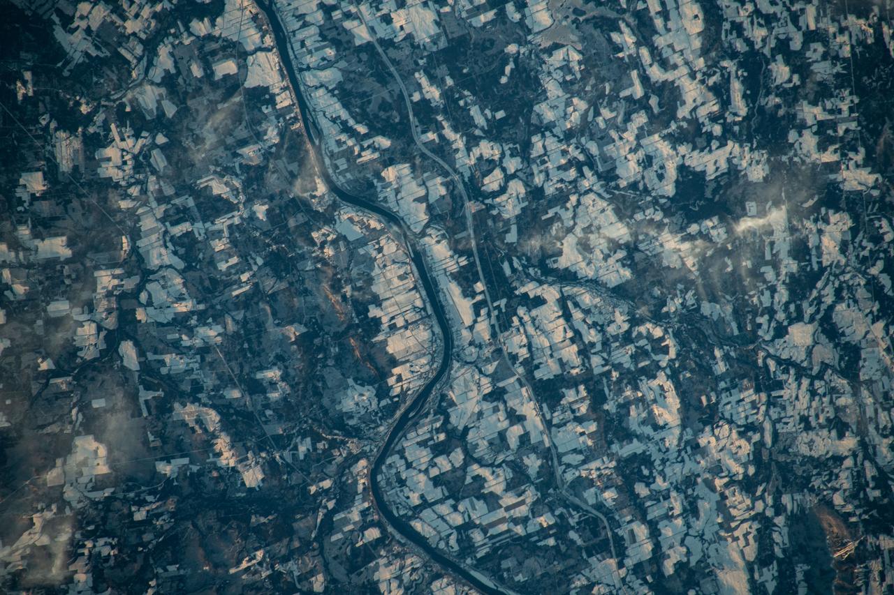
iss070e031278 (Nov. 25, 2023) --- The Canadian town of Carleton North, split by the St John River in the province of New Brunswick, borders Maine in the United States. The blue-gray colors of the landscape reveal the frigid temperatures in far North America in this photograph from the International Space Station as it orbited 262 miles above
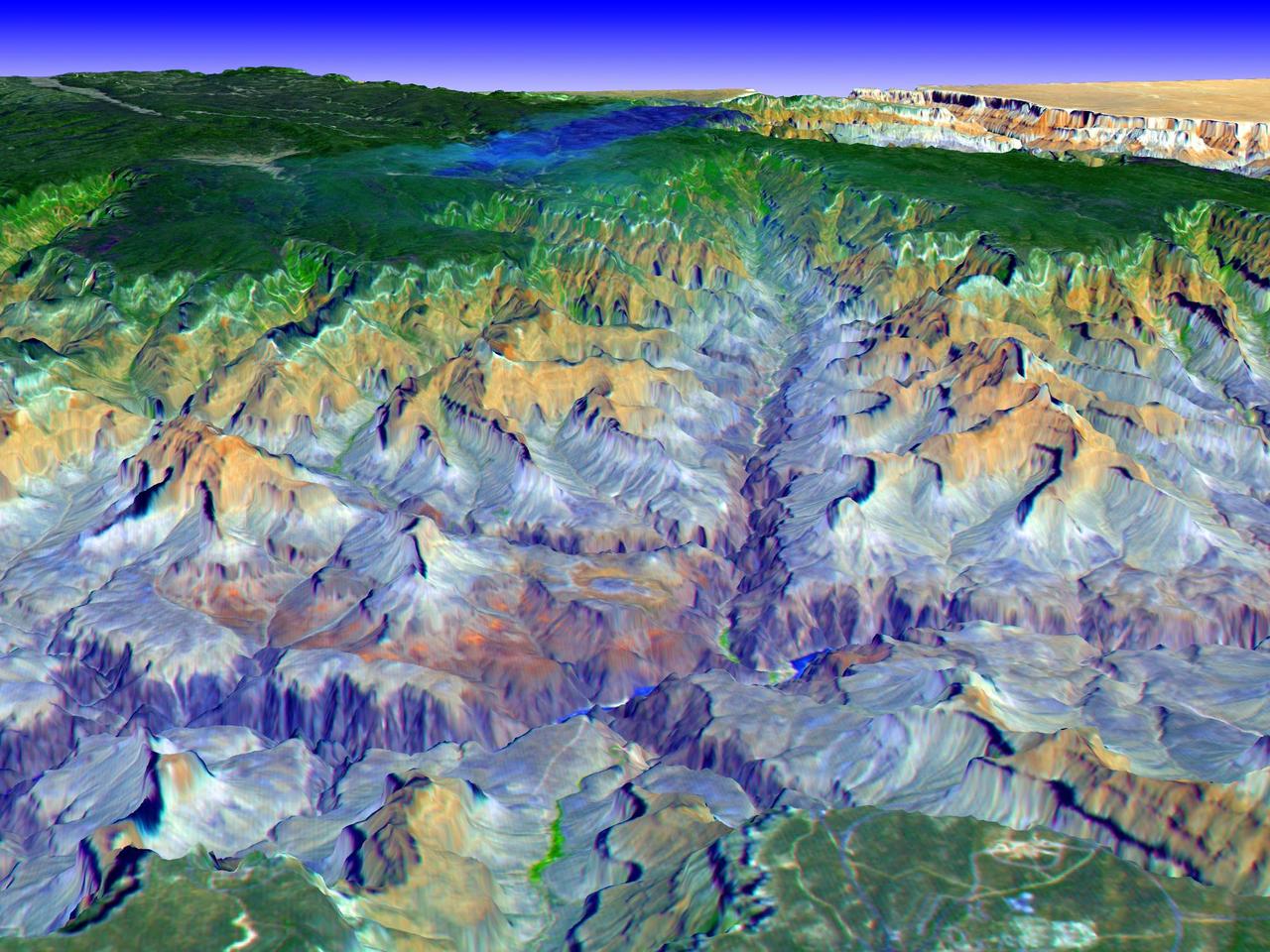
The Grand Canyon is one of North America's most spectacular geologic features. Carved primarily by the Colorado River over the past six million years, the canyon sports vertical drops of 5,000 feet and spans a 445-kilometer-long stretch of Arizona desert. The strata along the steep walls of the canyon form a record of geologic time from the Paleozoic Era (250 million years ago) to the Precambrian (1.7 billion years ago). The above view was acquired by the Advanced Spaceborne Thermal Emission and Reflection Radiometer (ASTER) instrument aboard the Terra spacecraft. Visible and near infrared data were combined to form an image that simulates the natural colors of water and vegetation. Rock colors, however, are not accurate. The image data were combined with elevation data to produce this perspective view, with no vertical exaggeration, looking from above the South Rim up Bright Angel Canyon towards the North Rim. The light lines on the plateau at lower right are the roads around the Canyon View Information Plaza. The Bright Angel Trail, which reaches the Colorado in 11.3 kilometers, can be seen dropping into the canyon over Plateau Point at bottom center. The blue and black areas on the North Rim indicate a forest fire that was smoldering as the data were acquired on May 12, 2000. http://photojournal.jpl.nasa.gov/catalog/PIA02668
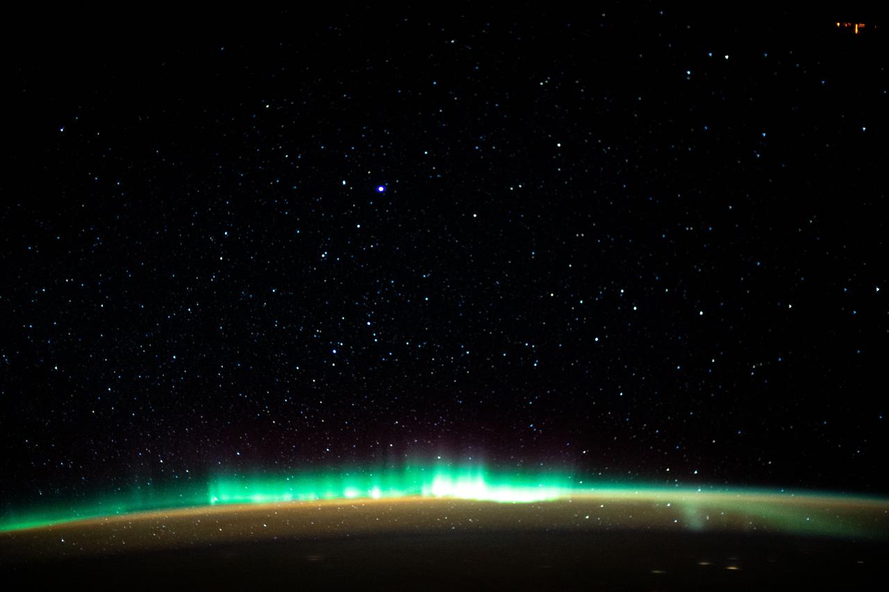
iss061e138167 (Jan. 22, 2020) --- An aurora blankets the Earth beneath a celestial night sky as the International Space Station orbited 261 miles above the Atlantic Ocean off the coast of North America.
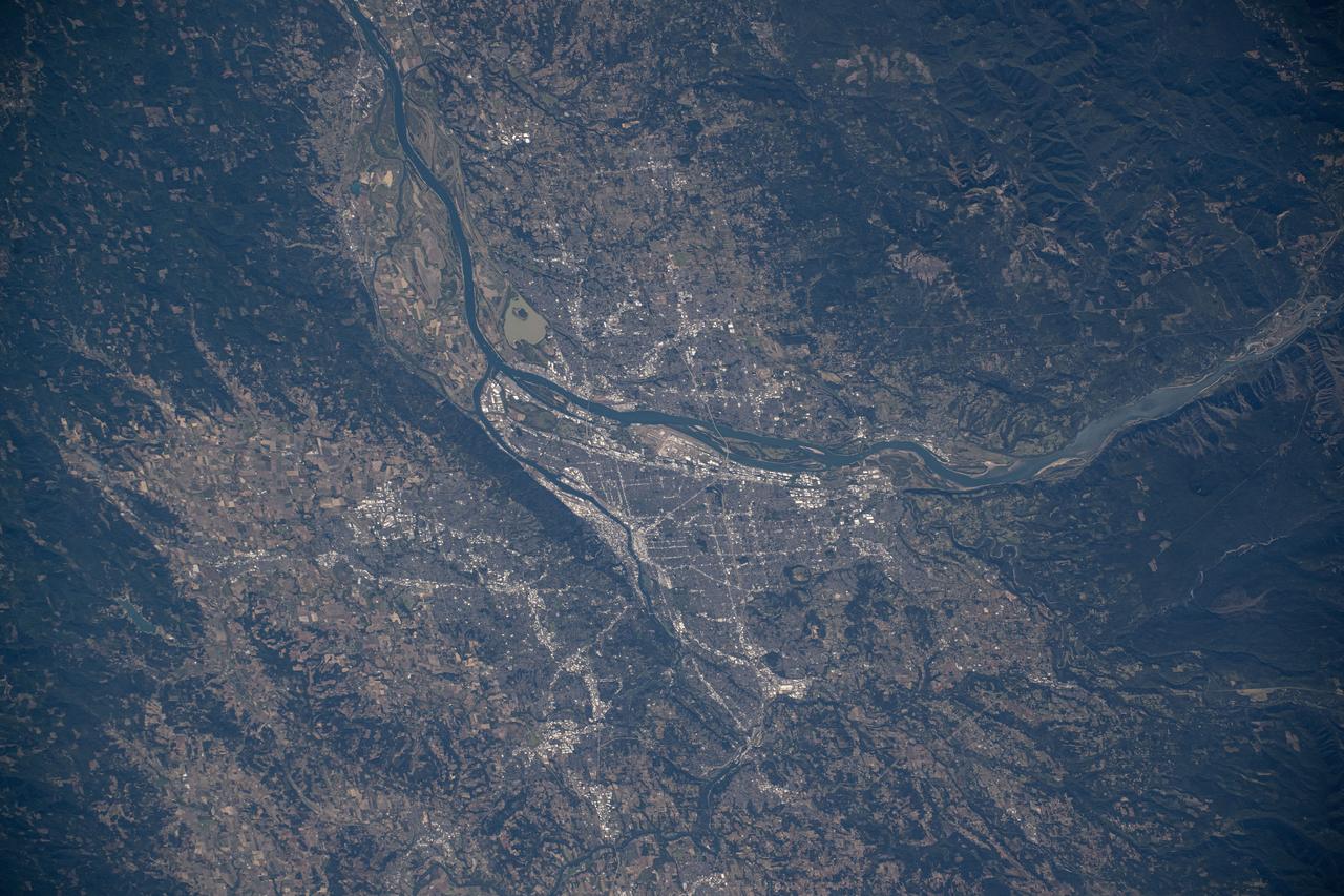
iss072e009893 (Oct. 1, 2024) --- Portland, Oregon, a city with a population of about 652,000 at the junction of the Willamette and Columbia Rivers, is pictured from the International Space Station as it orbited 259 miles above North America.
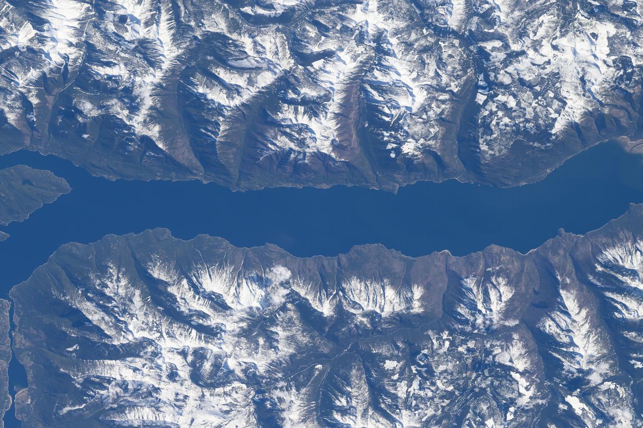
iss071e007896 (April 13, 2024) --- The southern portion of Kootenay Lake, sourrounded by the Canadian Rockies, in the Canadian province of British Columbia is pictured from the International Space Station as it orbited 260 miles above North America.
iss071e007913 (April 13, 2024) --- The Cypress Hills extend from the Canadian provinces of Alberta and Saskatchewan in this photograph from the International Space Station as it orbited 260 miles above North America.

iss065e376897 (Sept. 13, 2021) --- The International Space Station orbits 266 miles above the north Pacific Ocean off the coast of British Columbia, Canada, looking across the city lights of northwest America into a sunrise highlighted by an aurora.
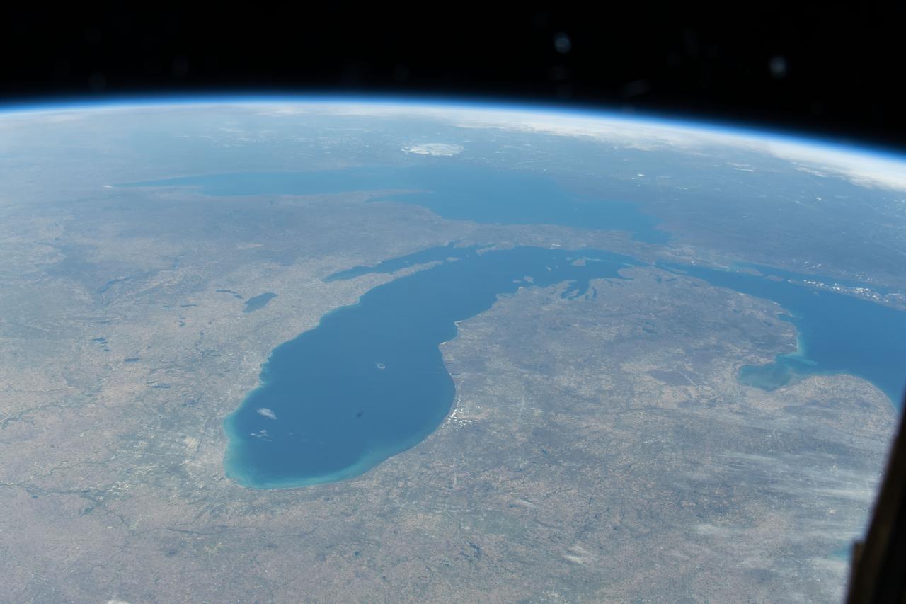
iss071e045652 (April 25, 2024) --- Lake Michigan figures prominently in the United States' upper midwest region with Lake Superior and Lake Huron in this photograph from the International Space Station as it orbited 257 miles above North America.
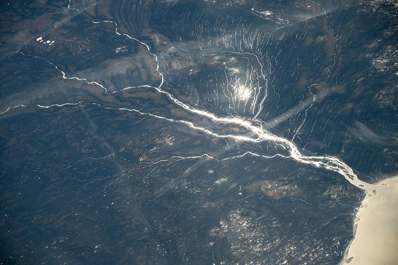
iss071e144724 (May 30, 2024) --- A sun glint-lit Moose River flows into James Bay in Ontario, Canada, in this photograph from the International Space Station as it orbited 264 miles above North America.
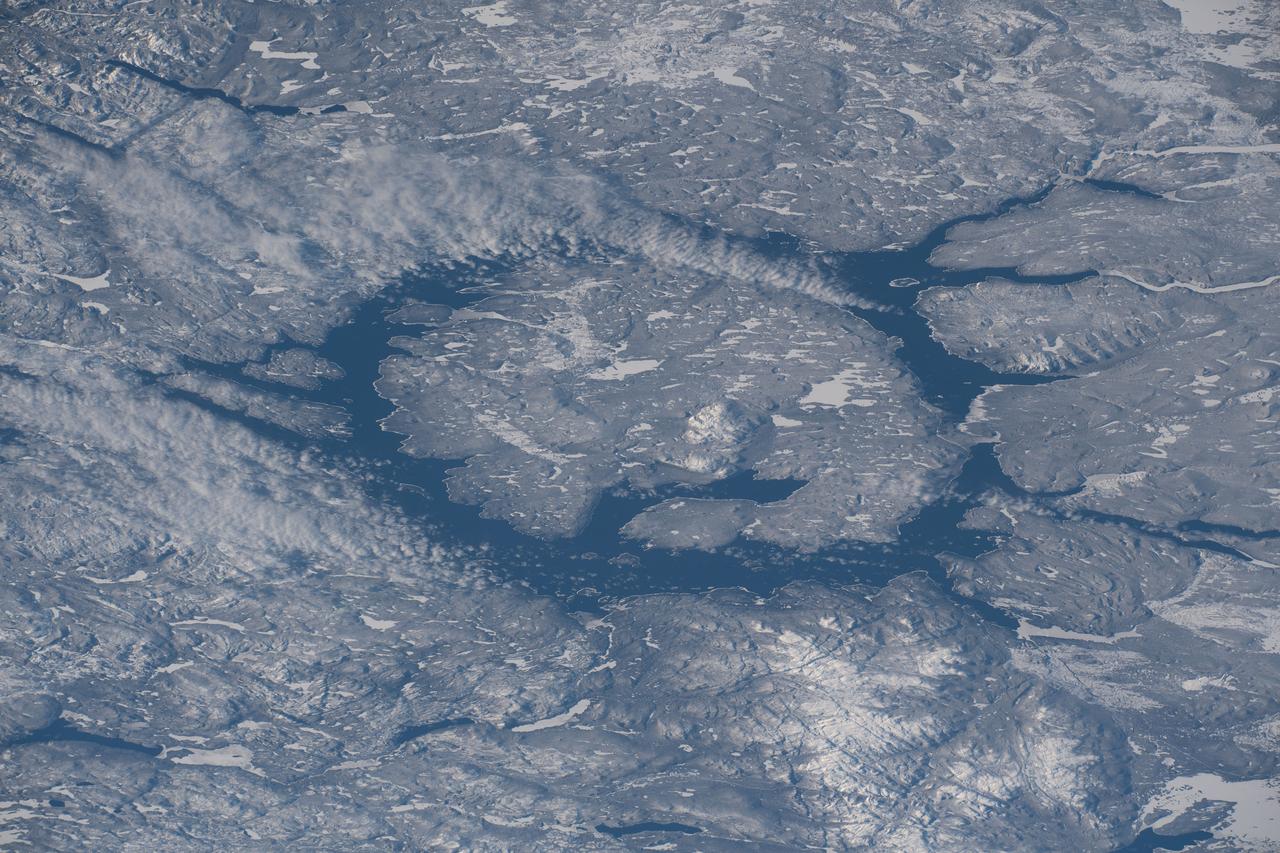
iss068e028530 (Dec. 10, 2022) --- Lake Manicouagan, formed by a meteoroid impact about 214 million years ago, in Quebec, Canada, is pictured from the International Space Station as it orbited 262 miles above North America.
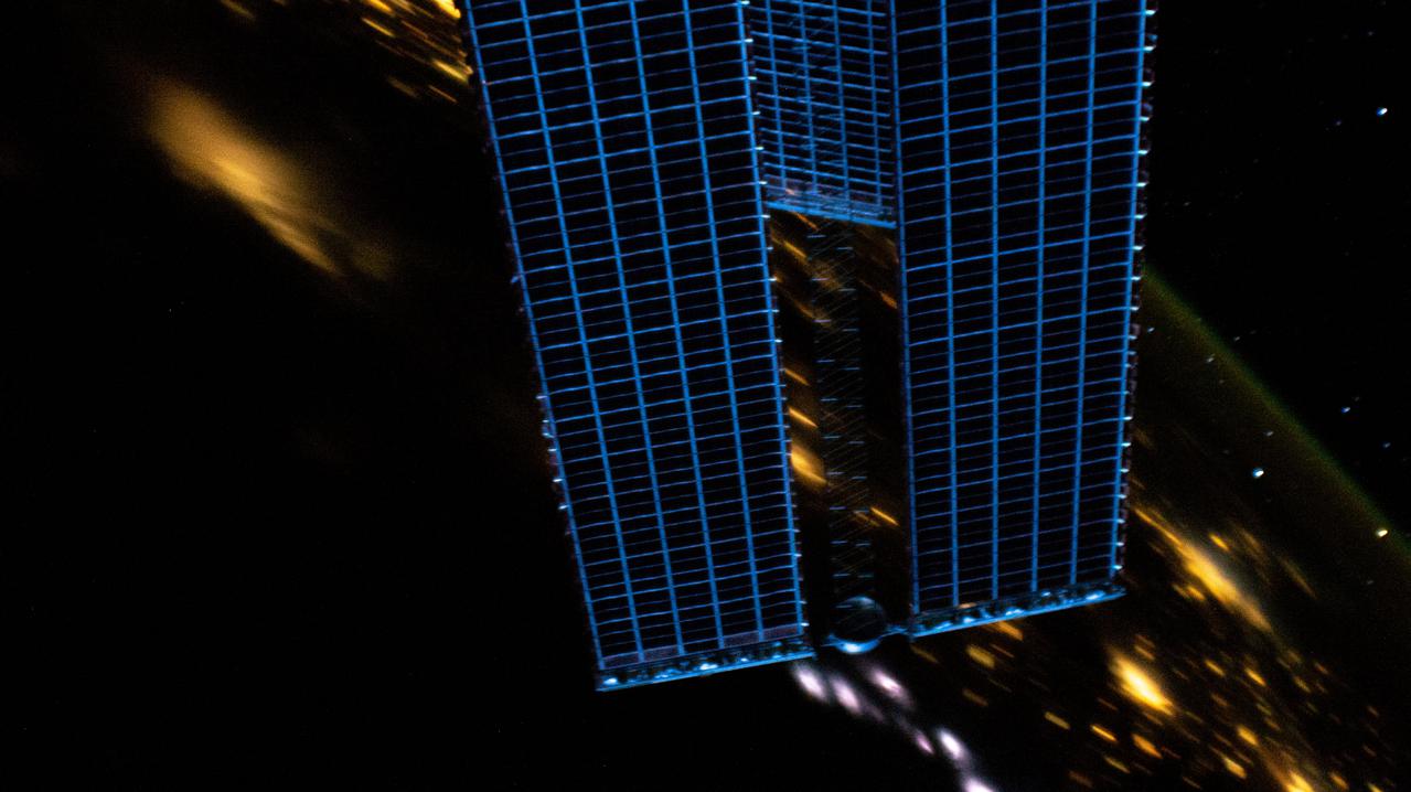
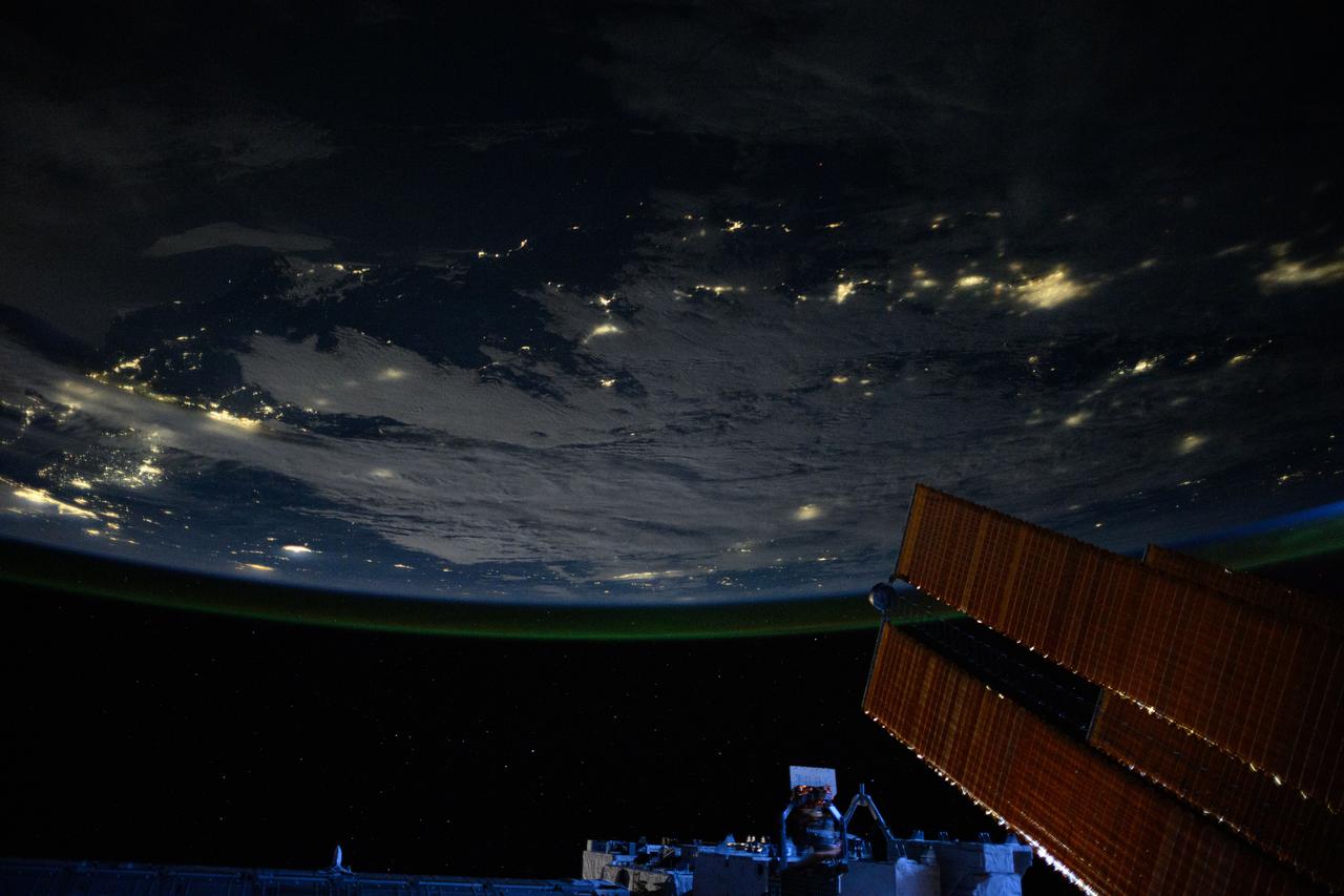
iss065e032043 (May 9, 2021) --- The night lights of North America, with the International Space Station's main solar arrays in the foreground, are pictured from the orbiting lab as it soared 264 miles above Wisconsin.
iss069e060945 (Aug. 15, 2023) --- Wildfires near Glacier Peak and Mount Baker in Washington state are pictured from the International Space Station as it orbited 265 miles above North America.
iss071e007986 (April 13, 2024) --- The Kenogami River, at the mouth of the Albany River (far right), is pictured in the Canadian province of Ontario from the International Space Station as it orbited 261 miles above North America.
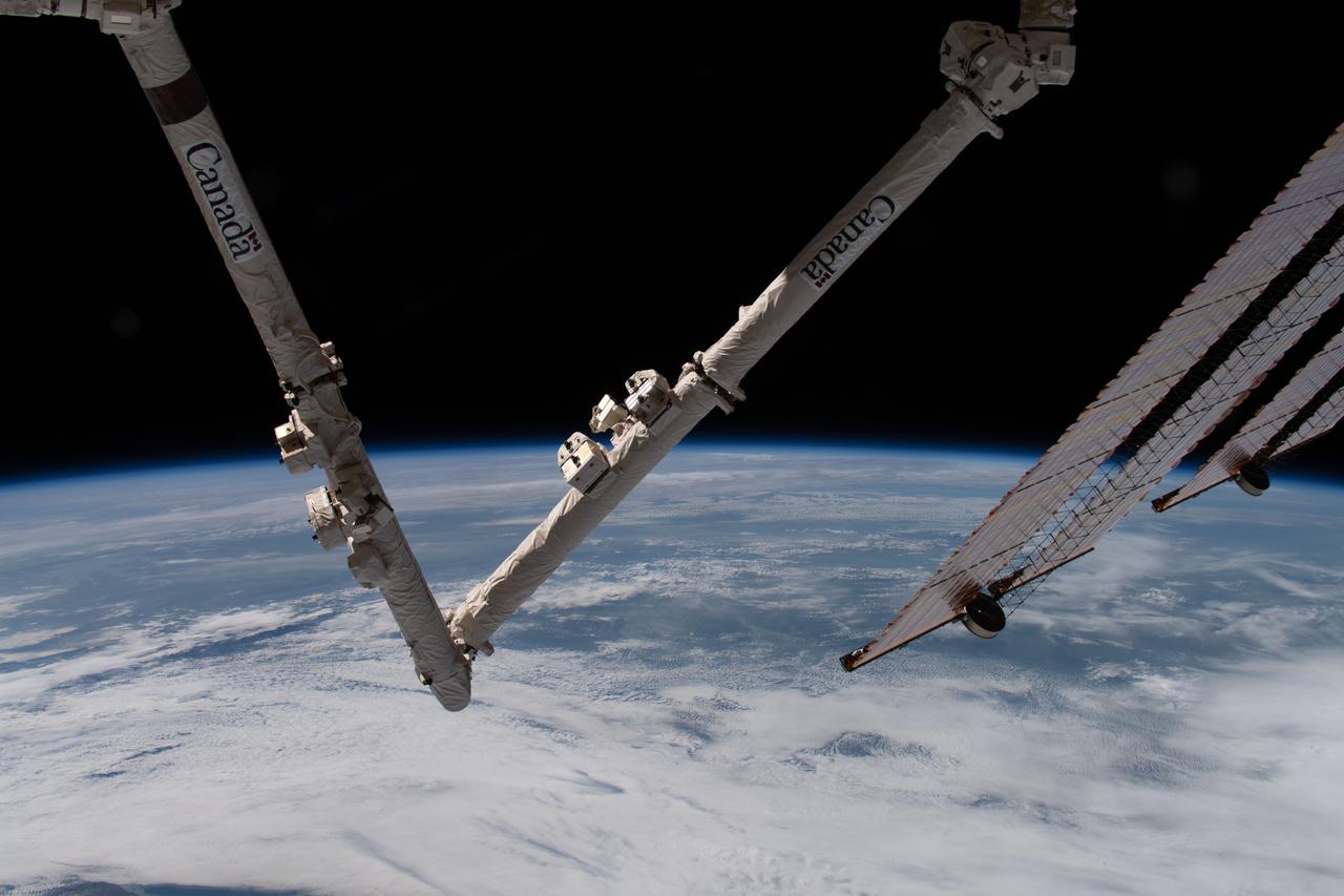
iss059e039713 (May 2, 2019) --- The Earth's limb and portions of the International Space Station's Canadarm2 robotic arm and solar arrays jut into the frame as the orbital complex flew 258 miles above the Great Lakes region of North America.
iss061e138170 (Jan. 22, 2020) --- An aurora blankets the Earth beneath a celestial night sky as the International Space Station orbited 261 miles above the Atlantic Ocean off the coast of North America.
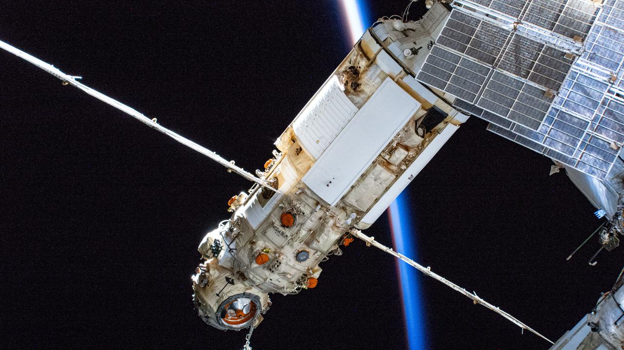
iss066e083228 (Nov. 26, 2021) --- Russia's Nauka multipurpose laboratory module is pictured as the International Space Station flew into an orbital sunset 267 miles above North America.
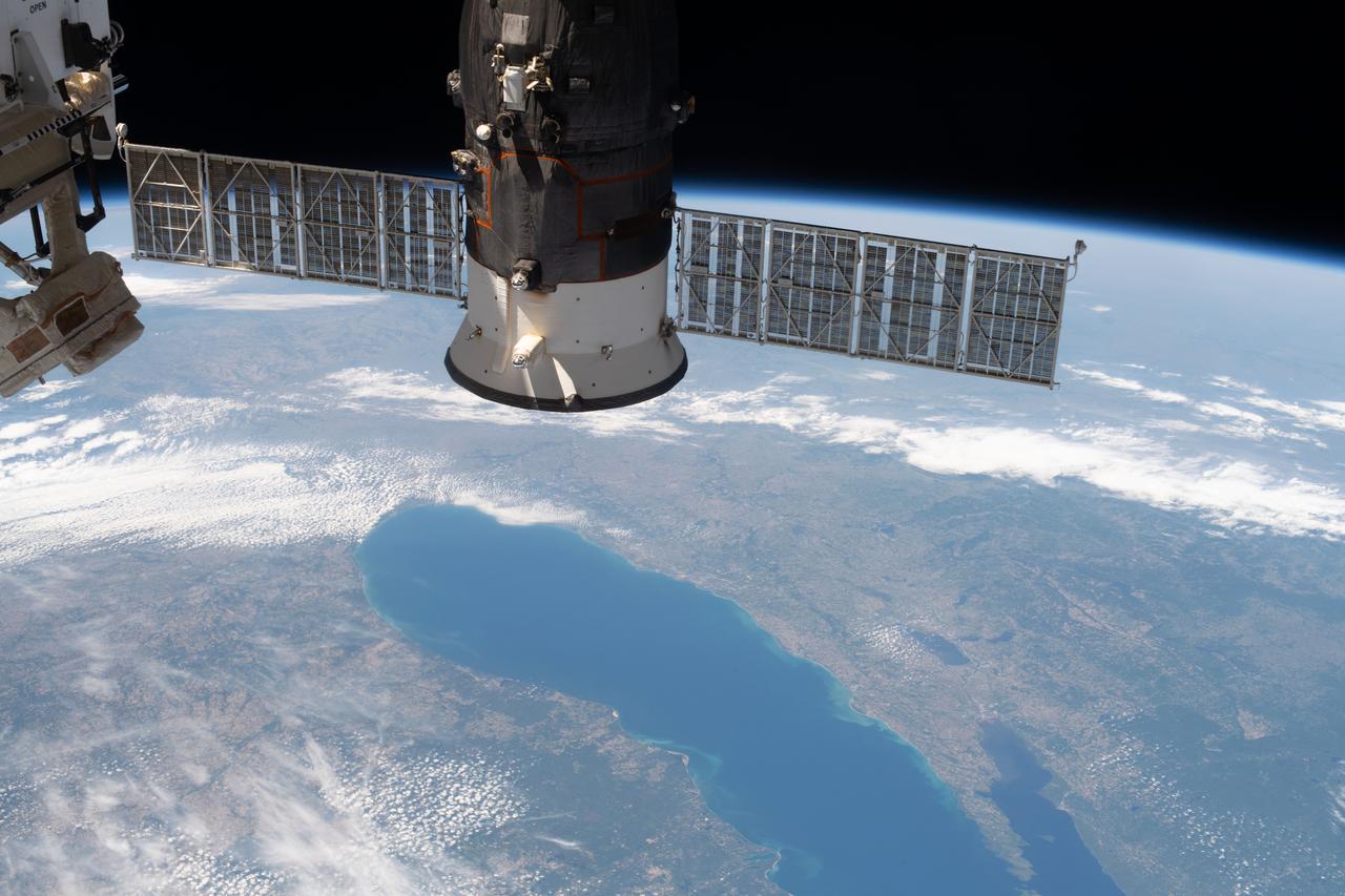
iss063e027839 (June 13, 2020) --- Lake Michigan figures prominently in this photograph of North America from the International Space Station with Russia's Progress 74 resupply ship in the foreground.
iss059e090279 (June 3, 2019) --- Lakes Erie and St. Clair and the cities of Detroit, Michigan and Toledo, Ohio are pictured as the International Space Station orbited 257 miles over North America.
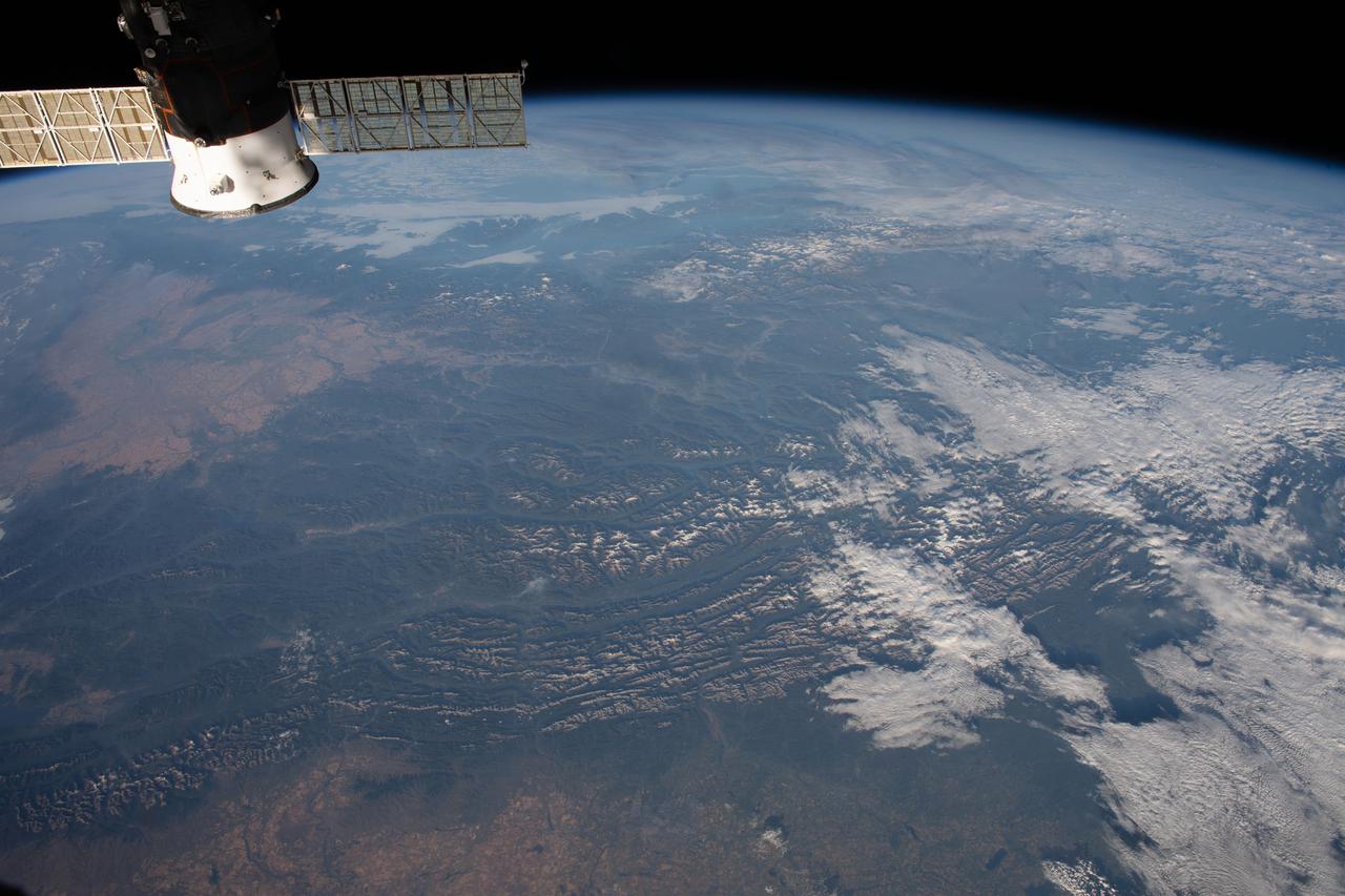
iss063e080437 (Aug. 26, 2020) --- The International Space Station was orbiting above North America when an Expedition 63 crew member, looking from northeast to southwest, photographed the Rocky Mountains running from Canada and into the United States.
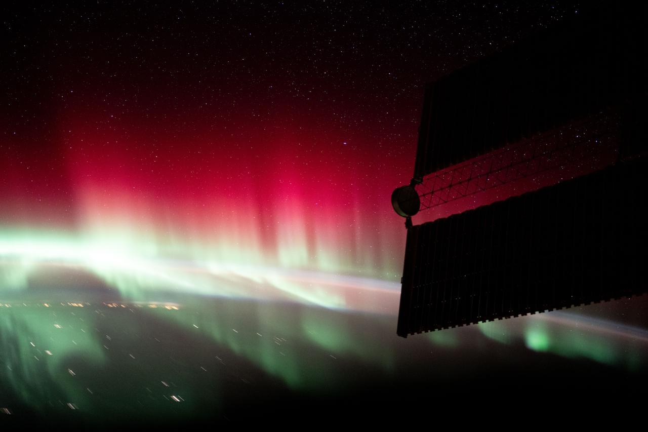
iss072e451023 (Jan. 4, 2025) --- A red and green aurora shimmers brightly above Ontario, Canada, near James Bay in this photograph from the International Space Station as it orbited 260 miles above North America.
iss071e009989 (April 18, 2024) --- The ice-covered Lakes Mistassini and Albanei in Canada's Quebec province are pictured from the International Space Station as it orbited 260 miles above North America.
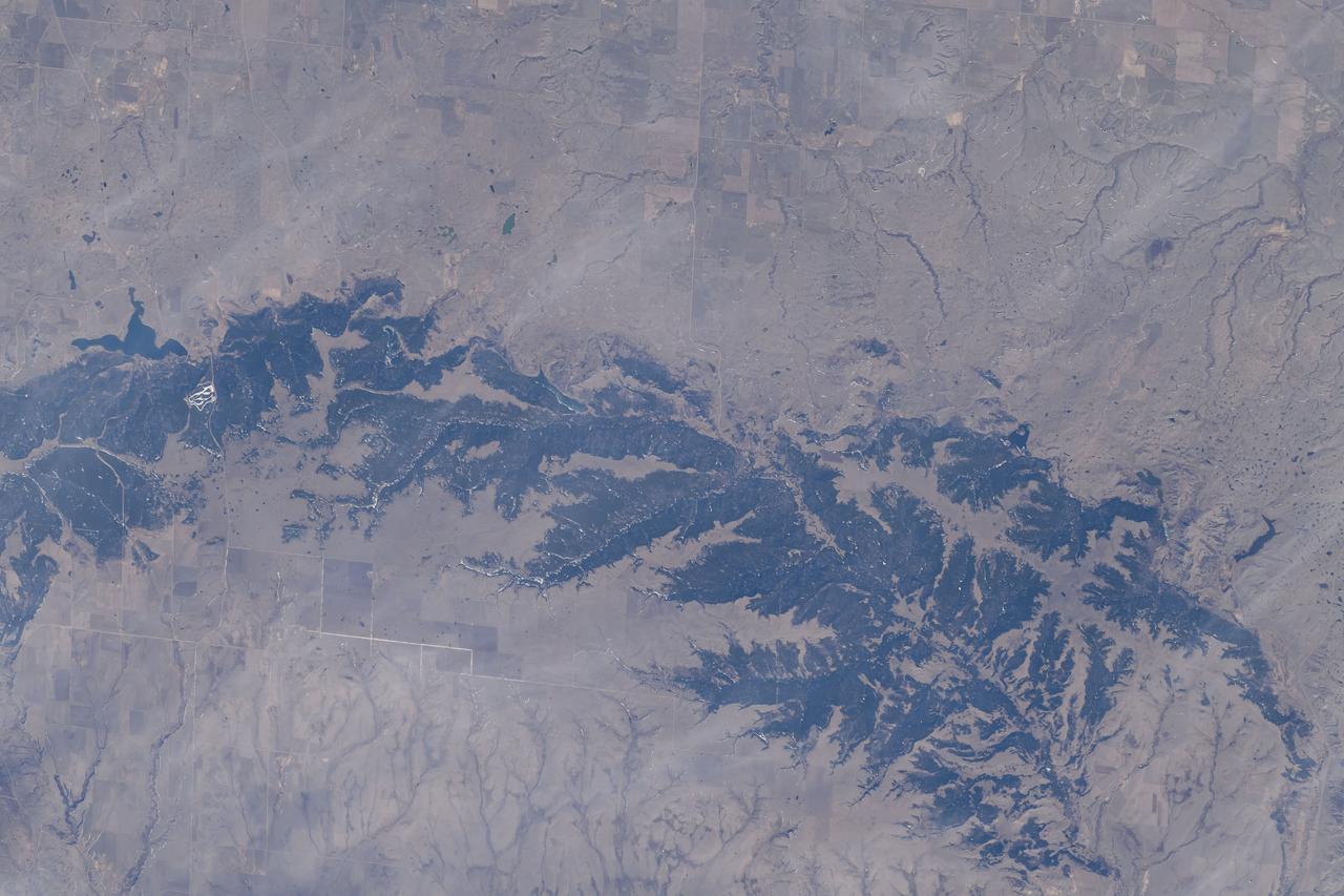
iss069e060833 (Aug. 15, 2023) --- South Dakota's Missouri River and its tributary the White River are pictured from the International Space Station as it orbited 264 miles above North America.

iss057e055582 (Oct. 22, 2018) --- A portion of Green River and its tributary canyons in the state of Utah were pictured as the International Space Station orbited 255 miles above North America.
iss067e147538 (June 22, 2022) --- Old Baldy Mountain peak (bottom right) and Dead Man's Basin Reservoir (top) in Montana are pictured from the International Space Station as it orbited 264 miles above North America.
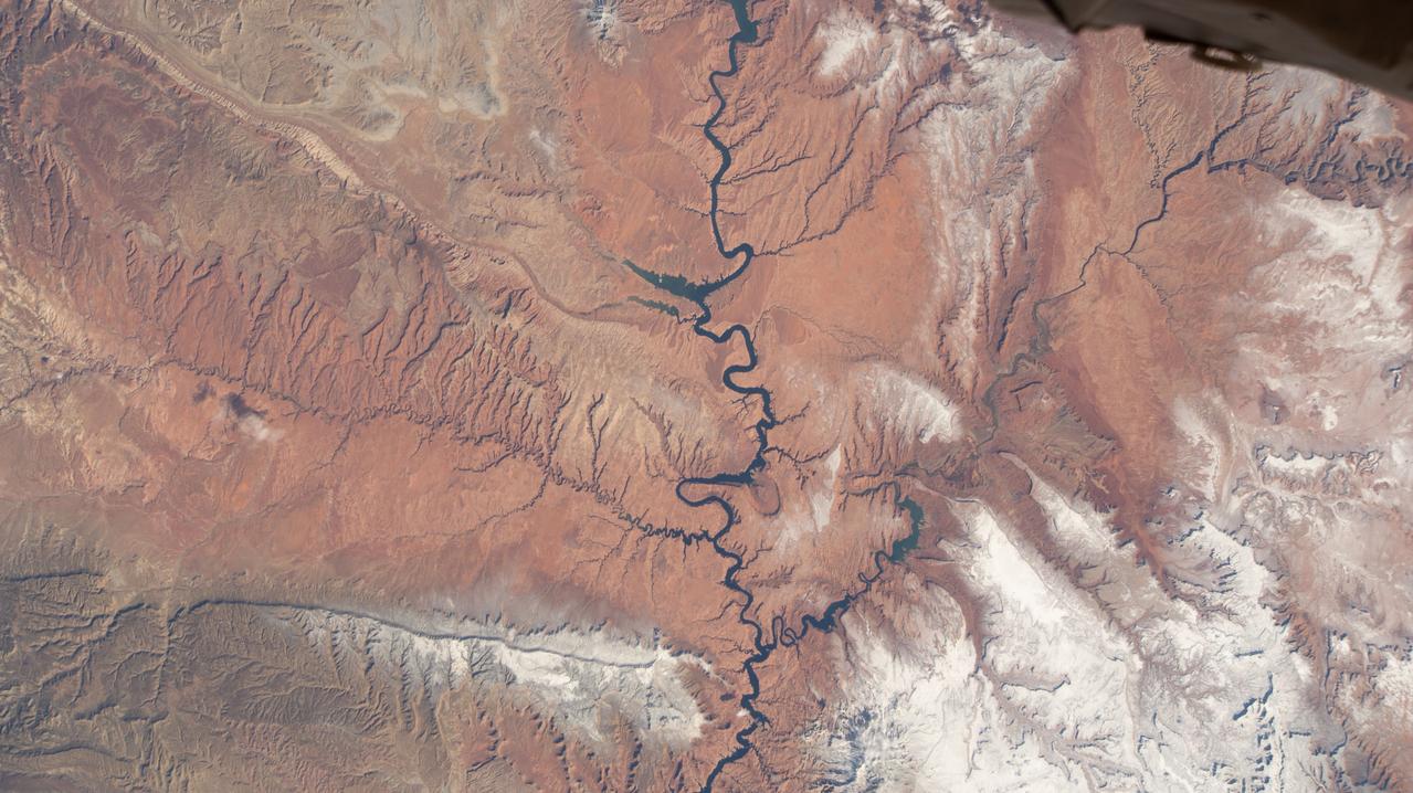
iss064e000624 (Oct. 26, 2020) --- Glen Canyon National Recreation Area and Lake Powell is pictured from the International Space Station as it orbited above Utah in North America.

iss068e011272 (Oct. 1, 2022) --- The Canadian Rockies in the Canadian provinces of British Columbia and Alberta are pictured from the International Space Station as it orbited 262 miles above North America. Credit: NASA/Bob Hines

iss068e011266 (Oct. 1, 2022) --- Vancouver in British Columbia, Canada (at top), and Seattle, Washington (lower right) are pictured from the International Space Station as it orbited 262 miles above North America. Credit: NASA/Bob Hines
iss067e213979 (Aug. 1, 2022) --- Lakes Winnipeg, Manitoba, and Winnipegosis, in the Canadian province of Manitoba, are pictured from the International Space Station as it orbited 260 miles above North America.

Guests learn about the total solar eclipse from NASA staff at the Dallas Arboretum, Monday, April 8, 2024, in Dallas, Texas. A total solar eclipse swept across a narrow portion of the North American continent from Mexico’s Pacific coast to the Atlantic coast of Newfoundland, Canada. A partial solar eclipse was visible across the entire North American continent along with parts of Central America and Europe. Photo Credit: (NASA/Keegan Barber) in Dallas, Texas on Monday, April 8, 2024. A total solar eclipse swept across a narrow portion of the North American continent from Mexico’s Pacific coast to the Atlantic coast of Newfoundland, Canada. A partial solar eclipse was visible across the entire North American continent along with parts of Central America and Europe. Photo Credit: (NASA/Keegan Barber)

Guests learn about the total solar eclipse from NASA staff at the Dallas Arboretum, Monday, April 8, 2024, in Dallas, Texas. A total solar eclipse swept across a narrow portion of the North American continent from Mexico’s Pacific coast to the Atlantic coast of Newfoundland, Canada. A partial solar eclipse was visible across the entire North American continent along with parts of Central America and Europe. Photo Credit: (NASA/Keegan Barber) in Dallas, Texas on Monday, April 8, 2024. A total solar eclipse swept across a narrow portion of the North American continent from Mexico’s Pacific coast to the Atlantic coast of Newfoundland, Canada. A partial solar eclipse was visible across the entire North American continent along with parts of Central America and Europe. Photo Credit: (NASA/Keegan Barber)

Guests learn about the total solar eclipse from NASA staff at the Dallas Arboretum, Monday, April 8, 2024, in Dallas, Texas. A total solar eclipse swept across a narrow portion of the North American continent from Mexico’s Pacific coast to the Atlantic coast of Newfoundland, Canada. A partial solar eclipse was visible across the entire North American continent along with parts of Central America and Europe. Photo Credit: (NASA/Keegan Barber) in Dallas, Texas on Monday, April 8, 2024. A total solar eclipse swept across a narrow portion of the North American continent from Mexico’s Pacific coast to the Atlantic coast of Newfoundland, Canada. A partial solar eclipse was visible across the entire North American continent along with parts of Central America and Europe. Photo Credit: (NASA/Keegan Barber)

Guests learn about the total solar eclipse from NASA staff at the Dallas Arboretum, Monday, April 8, 2024, in Dallas, Texas. A total solar eclipse swept across a narrow portion of the North American continent from Mexico’s Pacific coast to the Atlantic coast of Newfoundland, Canada. A partial solar eclipse was visible across the entire North American continent along with parts of Central America and Europe. Photo Credit: (NASA/Keegan Barber) in Dallas, Texas on Monday, April 8, 2024. A total solar eclipse swept across a narrow portion of the North American continent from Mexico’s Pacific coast to the Atlantic coast of Newfoundland, Canada. A partial solar eclipse was visible across the entire North American continent along with parts of Central America and Europe. Photo Credit: (NASA/Keegan Barber)

Guests learn about the total solar eclipse from NASA staff at the Dallas Arboretum, Monday, April 8, 2024, in Dallas, Texas. A total solar eclipse swept across a narrow portion of the North American continent from Mexico’s Pacific coast to the Atlantic coast of Newfoundland, Canada. A partial solar eclipse was visible across the entire North American continent along with parts of Central America and Europe. Photo Credit: (NASA/Keegan Barber) in Dallas, Texas on Monday, April 8, 2024. A total solar eclipse swept across a narrow portion of the North American continent from Mexico’s Pacific coast to the Atlantic coast of Newfoundland, Canada. A partial solar eclipse was visible across the entire North American continent along with parts of Central America and Europe. Photo Credit: (NASA/Keegan Barber)

Guests learn about the total solar eclipse from NASA staff at the Dallas Arboretum, Monday, April 8, 2024, in Dallas, Texas. A total solar eclipse swept across a narrow portion of the North American continent from Mexico’s Pacific coast to the Atlantic coast of Newfoundland, Canada. A partial solar eclipse was visible across the entire North American continent along with parts of Central America and Europe. Photo Credit: (NASA/Keegan Barber) in Dallas, Texas on Monday, April 8, 2024. A total solar eclipse swept across a narrow portion of the North American continent from Mexico’s Pacific coast to the Atlantic coast of Newfoundland, Canada. A partial solar eclipse was visible across the entire North American continent along with parts of Central America and Europe. Photo Credit: (NASA/Keegan Barber)

Guests learn about the total solar eclipse from NASA staff at the Dallas Arboretum, Monday, April 8, 2024, in Dallas, Texas. A total solar eclipse swept across a narrow portion of the North American continent from Mexico’s Pacific coast to the Atlantic coast of Newfoundland, Canada. A partial solar eclipse was visible across the entire North American continent along with parts of Central America and Europe. Photo Credit: (NASA/Keegan Barber) in Dallas, Texas on Monday, April 8, 2024. A total solar eclipse swept across a narrow portion of the North American continent from Mexico’s Pacific coast to the Atlantic coast of Newfoundland, Canada. A partial solar eclipse was visible across the entire North American continent along with parts of Central America and Europe. Photo Credit: (NASA/Keegan Barber)

Guests learn about the total solar eclipse from NASA staff at the Dallas Arboretum, Monday, April 8, 2024, in Dallas, Texas. A total solar eclipse swept across a narrow portion of the North American continent from Mexico’s Pacific coast to the Atlantic coast of Newfoundland, Canada. A partial solar eclipse was visible across the entire North American continent along with parts of Central America and Europe. Photo Credit: (NASA/Keegan Barber) in Dallas, Texas on Monday, April 8, 2024. A total solar eclipse swept across a narrow portion of the North American continent from Mexico’s Pacific coast to the Atlantic coast of Newfoundland, Canada. A partial solar eclipse was visible across the entire North American continent along with parts of Central America and Europe. Photo Credit: (NASA/Keegan Barber)

Guests learn about the total solar eclipse from NASA staff at the Dallas Arboretum, Monday, April 8, 2024, in Dallas, Texas. A total solar eclipse swept across a narrow portion of the North American continent from Mexico’s Pacific coast to the Atlantic coast of Newfoundland, Canada. A partial solar eclipse was visible across the entire North American continent along with parts of Central America and Europe. Photo Credit: (NASA/Keegan Barber) in Dallas, Texas on Monday, April 8, 2024. A total solar eclipse swept across a narrow portion of the North American continent from Mexico’s Pacific coast to the Atlantic coast of Newfoundland, Canada. A partial solar eclipse was visible across the entire North American continent along with parts of Central America and Europe. Photo Credit: (NASA/Keegan Barber)

Guests decorate their protective glasses at the Dallas Arboretum prior to the total solar eclipse, Monday, April 8, 2024, in Dallas, Texas. A total solar eclipse swept across a narrow portion of the North American continent from Mexico’s Pacific coast to the Atlantic coast of Newfoundland, Canada. A partial solar eclipse was visible across the entire North American continent along with parts of Central America and Europe. Photo Credit: (NASA/Keegan Barber) in Dallas, Texas on Monday, April 8, 2024. A total solar eclipse swept across a narrow portion of the North American continent from Mexico’s Pacific coast to the Atlantic coast of Newfoundland, Canada. A partial solar eclipse was visible across the entire North American continent along with parts of Central America and Europe. Photo Credit: (NASA/Keegan Barber)

Guests learn about the total solar eclipse from NASA staff at the Dallas Arboretum, Monday, April 8, 2024, in Dallas, Texas. A total solar eclipse swept across a narrow portion of the North American continent from Mexico’s Pacific coast to the Atlantic coast of Newfoundland, Canada. A partial solar eclipse was visible across the entire North American continent along with parts of Central America and Europe. Photo Credit: (NASA/Keegan Barber) in Dallas, Texas on Monday, April 8, 2024. A total solar eclipse swept across a narrow portion of the North American continent from Mexico’s Pacific coast to the Atlantic coast of Newfoundland, Canada. A partial solar eclipse was visible across the entire North American continent along with parts of Central America and Europe. Photo Credit: (NASA/Keegan Barber)

Guests learn about the total solar eclipse from NASA staff at the Dallas Arboretum, Monday, April 8, 2024, in Dallas, Texas. A total solar eclipse swept across a narrow portion of the North American continent from Mexico’s Pacific coast to the Atlantic coast of Newfoundland, Canada. A partial solar eclipse was visible across the entire North American continent along with parts of Central America and Europe. Photo Credit: (NASA/Keegan Barber) in Dallas, Texas on Monday, April 8, 2024. A total solar eclipse swept across a narrow portion of the North American continent from Mexico’s Pacific coast to the Atlantic coast of Newfoundland, Canada. A partial solar eclipse was visible across the entire North American continent along with parts of Central America and Europe. Photo Credit: (NASA/Keegan Barber)

Guests learn about the total solar eclipse from NASA staff at the Dallas Arboretum, Monday, April 8, 2024, in Dallas, Texas. A total solar eclipse swept across a narrow portion of the North American continent from Mexico’s Pacific coast to the Atlantic coast of Newfoundland, Canada. A partial solar eclipse was visible across the entire North American continent along with parts of Central America and Europe. Photo Credit: (NASA/Keegan Barber) in Dallas, Texas on Monday, April 8, 2024. A total solar eclipse swept across a narrow portion of the North American continent from Mexico’s Pacific coast to the Atlantic coast of Newfoundland, Canada. A partial solar eclipse was visible across the entire North American continent along with parts of Central America and Europe. Photo Credit: (NASA/Keegan Barber)

Guests learn about the total solar eclipse from NASA staff at the Dallas Arboretum, Monday, April 8, 2024, in Dallas, Texas. A total solar eclipse swept across a narrow portion of the North American continent from Mexico’s Pacific coast to the Atlantic coast of Newfoundland, Canada. A partial solar eclipse was visible across the entire North American continent along with parts of Central America and Europe. Photo Credit: (NASA/Keegan Barber) in Dallas, Texas on Monday, April 8, 2024. A total solar eclipse swept across a narrow portion of the North American continent from Mexico’s Pacific coast to the Atlantic coast of Newfoundland, Canada. A partial solar eclipse was visible across the entire North American continent along with parts of Central America and Europe. Photo Credit: (NASA/Keegan Barber)

Guests pose for a photo at the Dallas Arboretum, Monday, April 8, 2024, in Dallas, Texas. A total solar eclipse swept across a narrow portion of the North American continent from Mexico’s Pacific coast to the Atlantic coast of Newfoundland, Canada. A partial solar eclipse was visible across the entire North American continent along with parts of Central America and Europe. Photo Credit: (NASA/Keegan Barber) in Dallas, Texas on Monday, April 8, 2024. A total solar eclipse swept across a narrow portion of the North American continent from Mexico’s Pacific coast to the Atlantic coast of Newfoundland, Canada. A partial solar eclipse was visible across the entire North American continent along with parts of Central America and Europe. Photo Credit: (NASA/Keegan Barber)
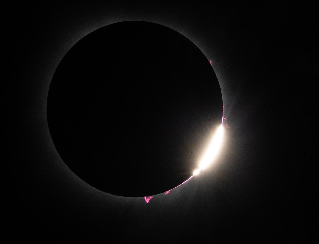
Bailey's Beads and solar prominences are seen just after totality in Dallas, Texas on Monday, April 8, 2024. A total solar eclipse swept across a narrow portion of the North American continent from Mexico’s Pacific coast to the Atlantic coast of Newfoundland, Canada. A partial solar eclipse was visible across the entire North American continent along with parts of Central America and Europe. Photo Credit: (NASA/Keegan Barber) in Dallas, Texas on Monday, April 8, 2024. A total solar eclipse swept across a narrow portion of the North American continent from Mexico’s Pacific coast to the Atlantic coast of Newfoundland, Canada. A partial solar eclipse was visible across the entire North American continent along with parts of Central America and Europe. Photo Credit: (NASA/Keegan Barber)

AS08-16-2593 (21-27 Dec. 1968) --- A striking view from the Apollo 8 spacecraft showing nearly the entire Western Hemisphere, from the mouth of the St. Lawrence River, including nearby Newfoundland, extending to Tierra del Fuego at the southern tip of South America. Central America is clearly outlined. Nearly all of South America is covered by clouds, except the high Andes Mountain chain along the west coast. A small portion of the bulge of West Africa shows along the sunset terminator.

Senior executives from the Renault-Nissan Alliance, including Carlos Ghosn, chairman and CEO of Nissan, and Jose Munoz, chairman of Nissan North America, visited Ames for meetings and a showcase of the technical partnership between NASA and Nissan North America. The partnership allows researchers to develop and test autonomy algorithms, concepts, and integrated prototypes for a variety of vehicular transport applications – from rovers to self-driving cars. After briefings, a group take a ride in the autonomous vehicle to observed testing of Nissan’s all-electric LEAF as it performed safe autonomous drives across the center.
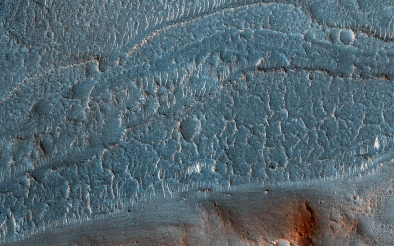
Cataracts are large landforms, and this oblique image from NASA's Mars Reconnaissance Orbiter covers only a small area of the innermost channel. The ridged material on the channel floor may be a lava flow that followed this channel after it was initially carved by giant floods of water.Obviously these are not the kind of cataracts that can develop in the lenses of your eyes, but large erosional scallops that form in river channels, like the Niagara Falls draining the Great Lakes of North America. Obviously these are not the kind of cataracts that can develop in the lenses of your eyes, but large erosional scallops that form in river channels, like the Niagara Falls draining the Great Lakes of North America. https://photojournal.jpl.nasa.gov/catalog/PIA21869

JSC2012-E-029874 (14 Feb. 2012) --- During a ceremony on Feb. 14 at the Astrium North America facility in Houston, two principal participants shake hands as a gravitational research centrifuge gets handed over by Astrium ST to NanoRacks LLC representatives. The handshake of Ulrich Kuebler (second right) of Astrium ST and Jeff Manber, managing director of NanoRacks, symbolizes the working relationship between Astrium ST and NanoRacks, who are working in cooperation with NASA, to deliver the commercial centrifuge facility to the International Space Station. At left are Luca Pieroni of Kayser Italia, one of Astrium's partners in construction the centrifuge, and Achim Schwarzwaelder of Astrium ST . NASA Photo courtesy Astrium North America

Senior executives from the Renault-Nissan Alliance, including Carlos Ghosn, chairman and CEO of Nissan, and Jose Munoz, chairman of Nissan North America, visited Ames for meetings and a showcase of the technical partnership between NASA and Nissan North America. The partnership allows researchers to develop and test autonomy algorithms, concepts, and integrated prototypes for a variety of vehicular transport applications – from rovers to self-driving cars. After briefings, a company of including Eugene Tu, Ames Center Director andLiam Pedersen, Nissan on right Carlos Ghosn, CE, Nissan on left climb into in the autonomous vehicle to observed testing of Nissan’s all-electric LEAF as it performed safe autonomous drives across the center.

JSC2012-E-029875 (14 Feb. 2012) --- During a ceremony on Feb. 14 at the Astrium North America facility in Houston, two principal participants shake hands as a gravitational research centrifuge gets handed over by Astrium ST to NanoRacks LLC representatives. The handshake of Ulrich Kuebler (second right) of Astrium ST and Jeff Manber, managing director of NanoRacks, symbolizes the working relationship between Astrium ST and NanoRacks, who are working in cooperation with NASA, to deliver the commercial centrifuge facility to the International Space Station. At left is Achim Schwarzwaelder of Astrium ST. NASA Photo courtesy Astrium North America

JSC2012-E-029877 (14 Feb. 2012) --- During a ceremony on Feb. 14, at the Astrium North America facility in Houston, some of the principal participants stand near a gravitational research centrifuge which Astrium ST handed over to NanoRacks LLC representatives. From the left are Jeanne Becker, President, CEO and Executive Director of the Center for the Advancement of Science in Space (CASIS); Ulrich Kuebler of Astrium ST ; Jeff Manber, managing director of NanoRacks; and Marybeth Edeen, U.S. National Lab manager at NASA?s Johnson Space Center. NASA Photo courtesy Astrium North America

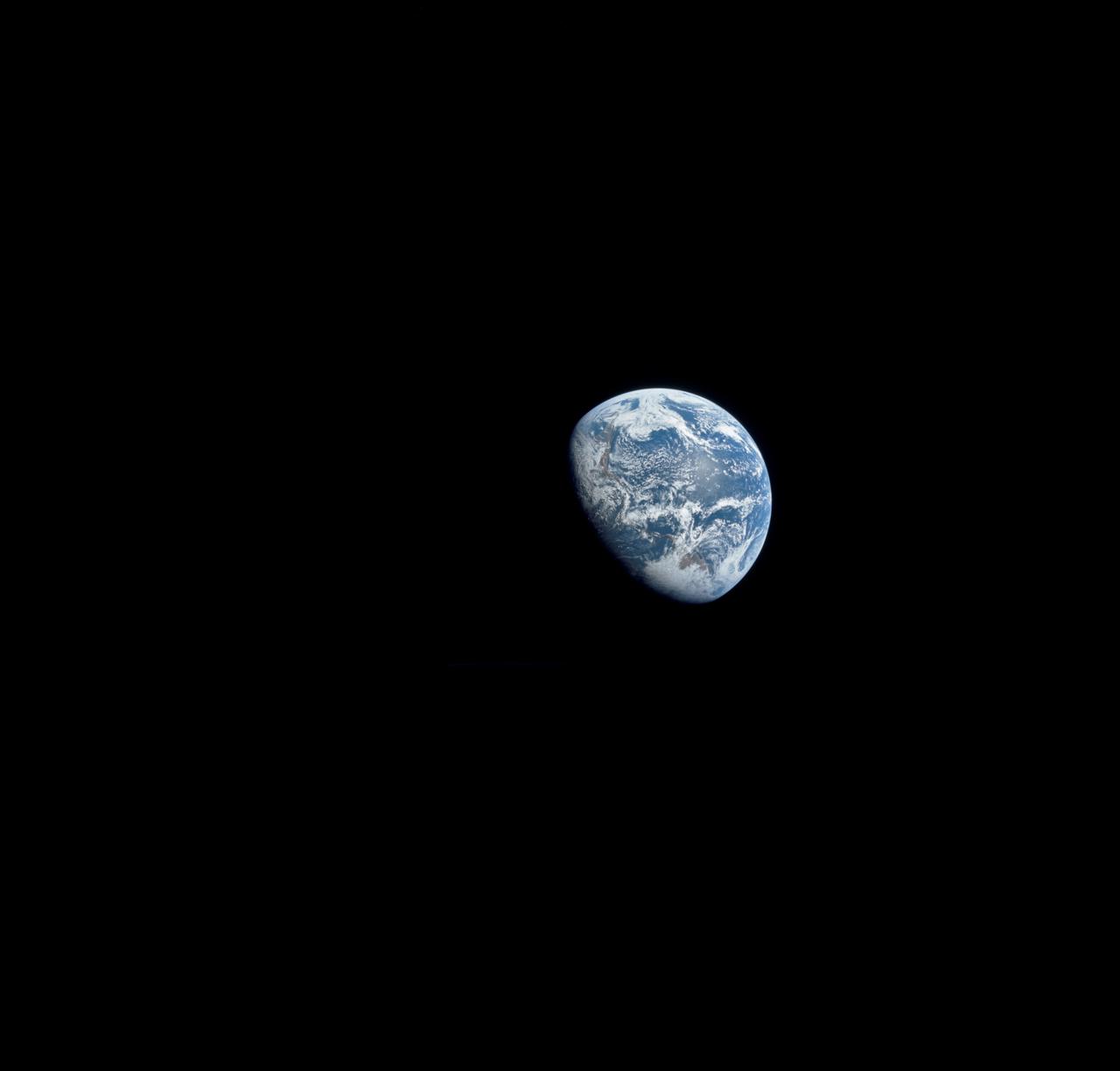
AS11-36-5337 (16 July 1969) --- This view of Earth showing clouds over its surface was photographed from the Apollo 11 spacecraft during its translunar journey toward the moon. The spacecraft was already about 10,000 nautical miles from Earth when this picture was taken. Portions of the land mass of North America and Central America can be seen. Aboard Apollo 11 were astronauts Neil A. Armstrong, Michael Collins and Edwin E. Aldrin Jr.
art001e002202 (Dec. 8, 2022) On flight day 23 of NASA’s Artemis I mission, Orion’s solar array wing camera looked back at the Moon as the spacecraft continued its journey back to Earth ahead of a splashdown off the west coast of North America on Dec. 11.
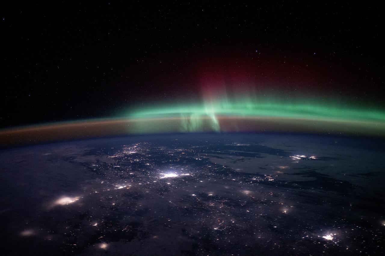
iss072e725406 (March 5, 2025) --- City lights dot the Canadian landscape underneath an atmospheric glow and an aurora borealis in this photograph taken from the International Space Station 262 miles above North America at approximately 12:15 a.m. local time.
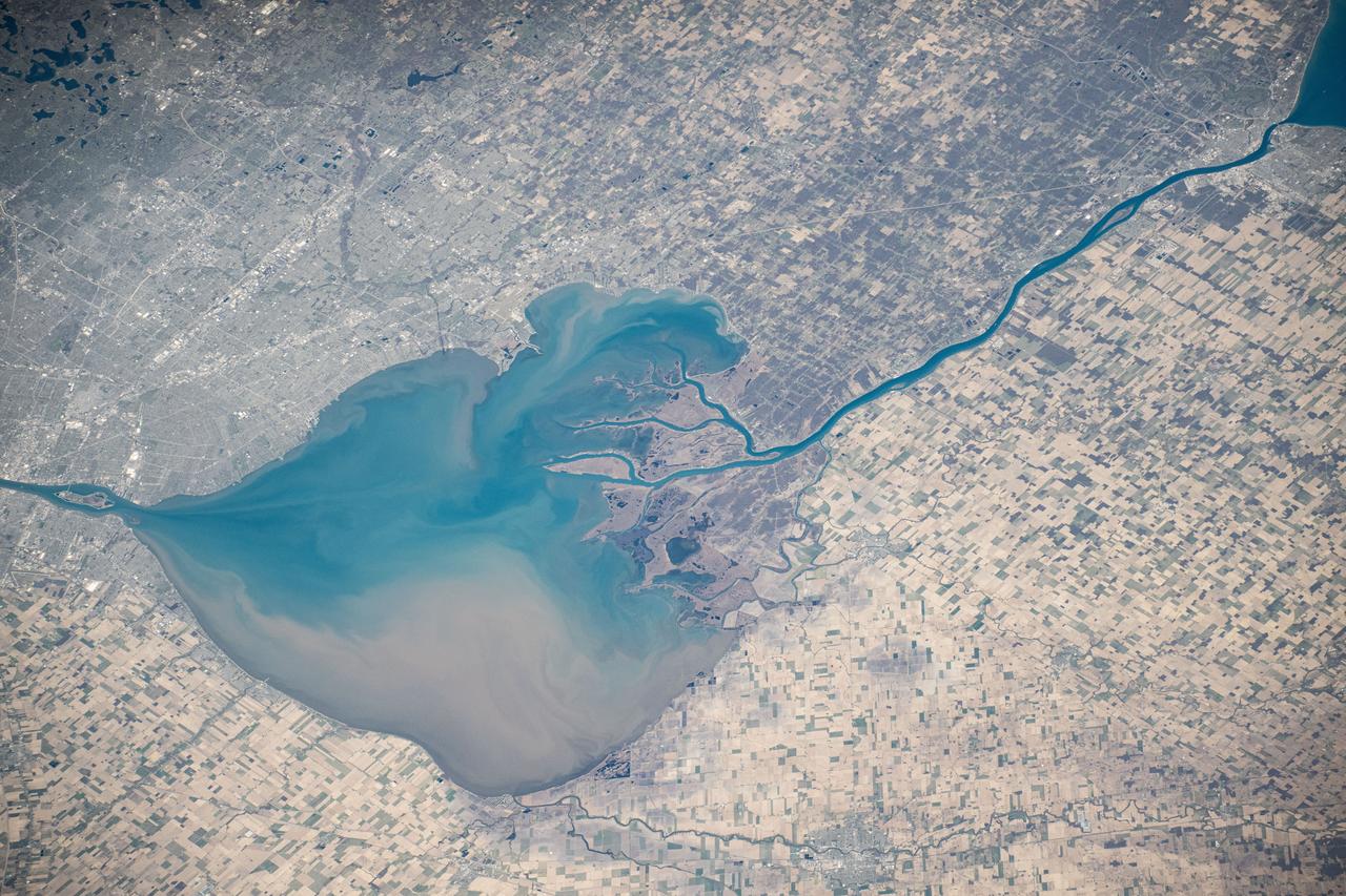
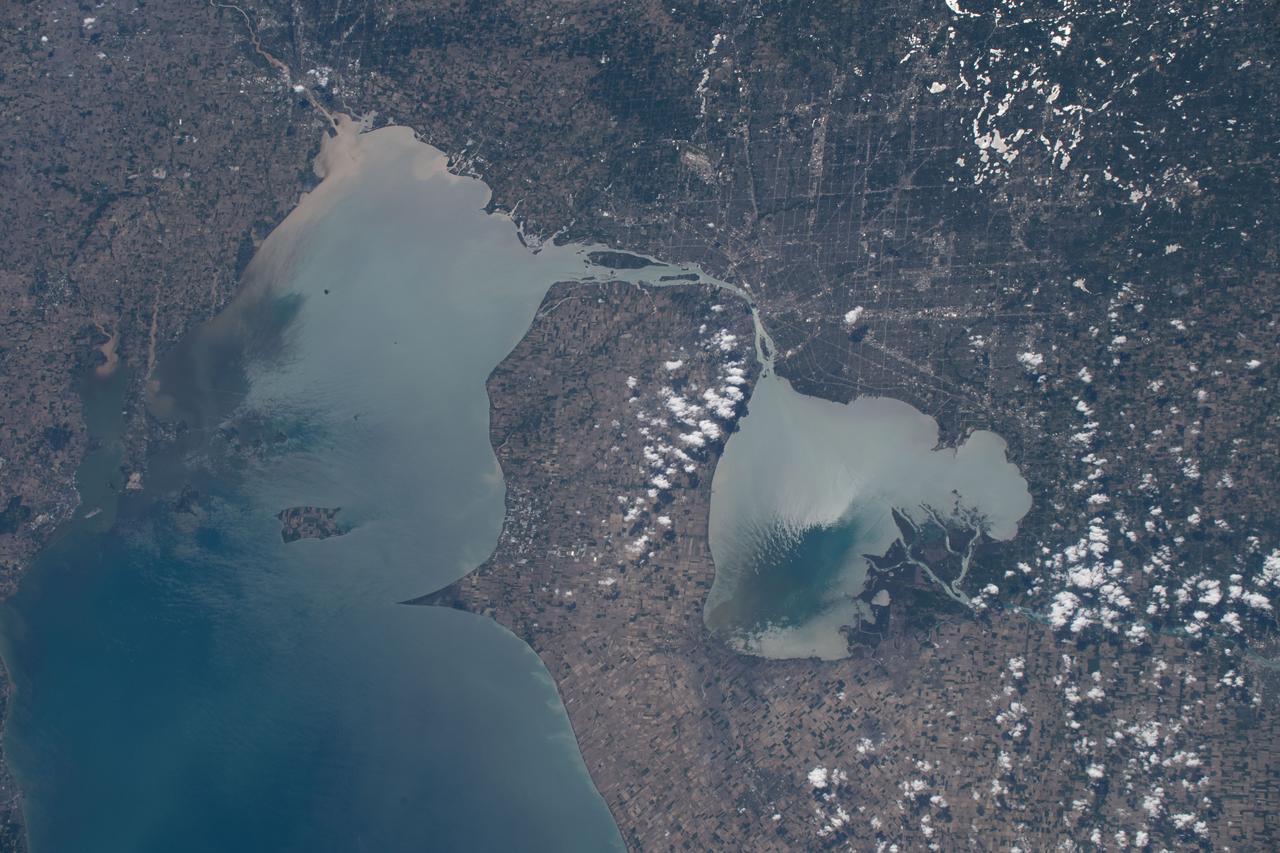
iss073e0000553 (April 22, 2025) --- The freshwater Lake St. Clair rests in between Detroit, Michigan (left), and Ontario, Canada, and connects Lake Huron and Lake Erie in North America in this photograph from the International Space Station as it orbited 260 miles above.

iss061e004579 (Oct. 18, 2019) --- The Nottaway River empties into the southern tip of James Bay in the Canadian province of Quebec. The International Space Station was orbiting 252 miles above North America and 189 miles south of James Bay at the time this photograph was taken.
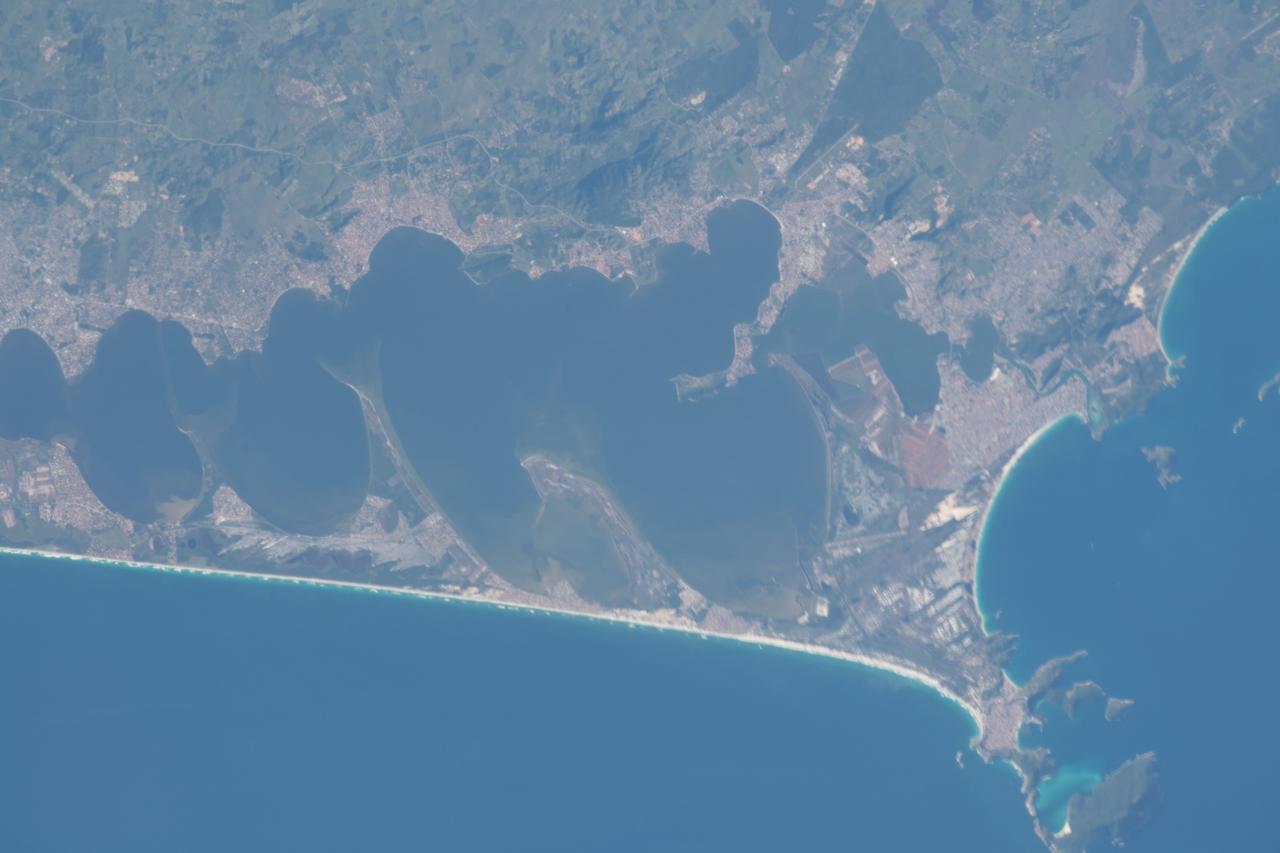
iss063e003285 (April 24, 2020) --- The Araruama Lagoon is about 52 miles east of Rio de Janeiro on the Atlantic coast of Brazil. The International Space Station was flying just north of Sao Paolo, South America's largest city when this photograph was taken.
iss067e265450 (Aug. 14, 2022) --- The Moon's glint beams off lakes on the U.S.-Canadian border, between the state of Minnesota and the province of Ontario, in this nighttime photograph from the International Space Station as it orbited 260 miles above North America.