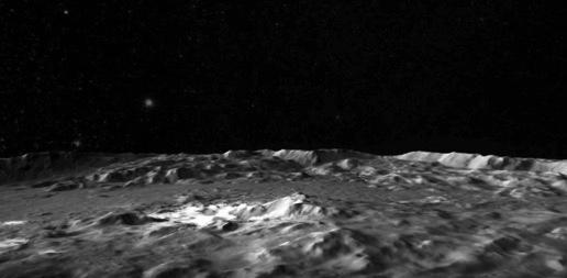
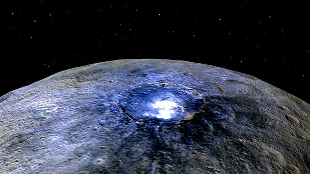
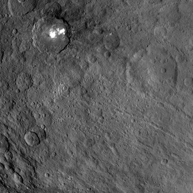
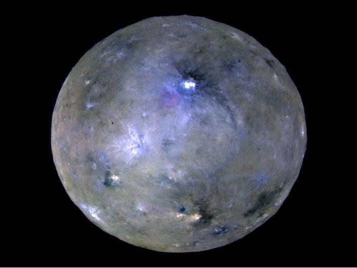
This frame from a video shows a flyover of the intriguing crater named Occator on dwarf planet Ceres. Occator is home to Ceres brightest area. Occator is home to Ceres' brightest area. It may have been produced by upwelling of salt-rich liquids after the impact that formed the crater. The animated flyover includes topographic and enhanced-color views of the crater, highlighting the central dome feature. The central area has been named Cerealia Facula. Occator's secondary group of bright spots is called Vinalia Faculae. A video is available at http://photojournal.jpl.nasa.gov/catalog/PIA21080
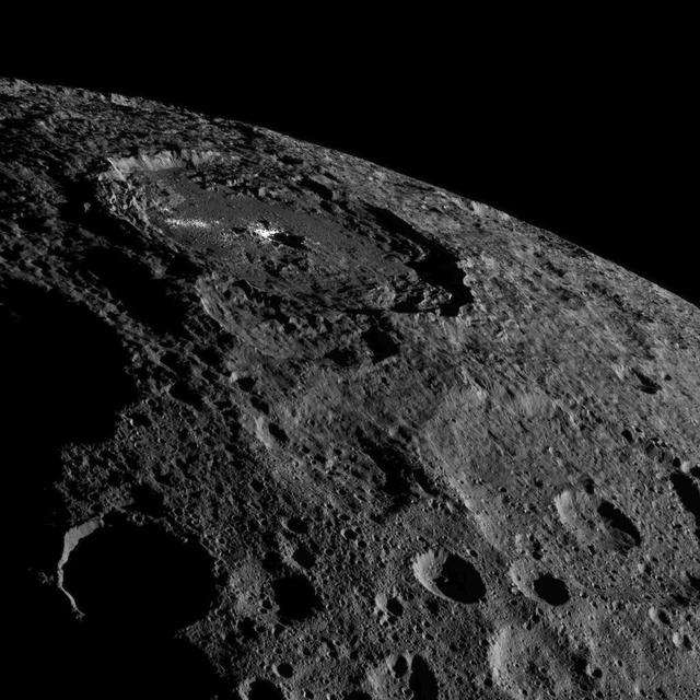
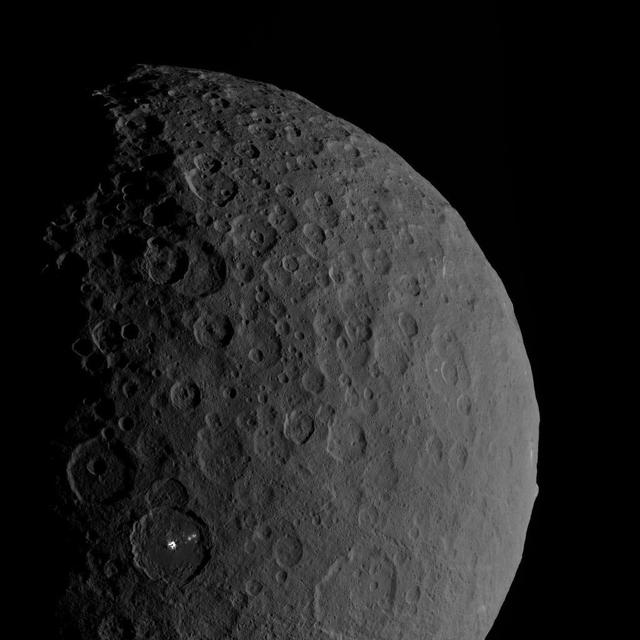
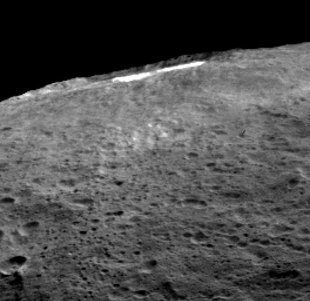
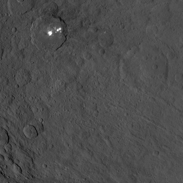
This image of the limb of dwarf planet Ceres shows a section of the northern hemisphere. Prominently featured is Occator Crater, home of Ceres' intriguing brightest areas. At 57 miles (92 kilometers) wide and 2.5 miles (4 kilometers) deep, Occator displays evidence of recent geologic activity. The latest research suggests that the bright material in this crater is comprised of salts left behind after a briny liquid emerged from below, froze and then sublimated, meaning it turned from ice into vapor. Dawn took this image on Oct. 17 from its second extended-mission science orbit (XMO2), at a distance of about 920 miles (1,480 kilometers) above the surface. The image resolution is about 460 feet (140 meters) per pixel. http://photojournal.jpl.nasa.gov/catalog/PIA21078
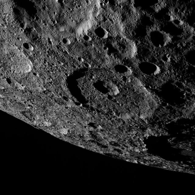
This image of the limb of dwarf planet Ceres shows a section of the northern hemisphere. A shadowy portion of Occator Crater can be seen at the lower right -- its bright "spot" areas are outside of the frame of view. Part of Kaikara Crater (45 miles, 72 kilometers in diameter) is visible at top left. Dawn took this image on Oct. 17 from its second extended-mission science orbit (XMO2), at a distance of about 920 miles (1,480 kilometers) above the surface. The image resolution is about 460 feet (140 meters) per pixel. http://photojournal.jpl.nasa.gov/catalog/PIA21230
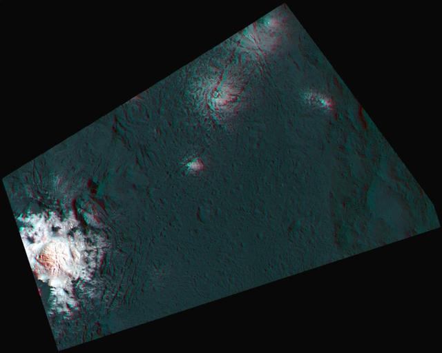
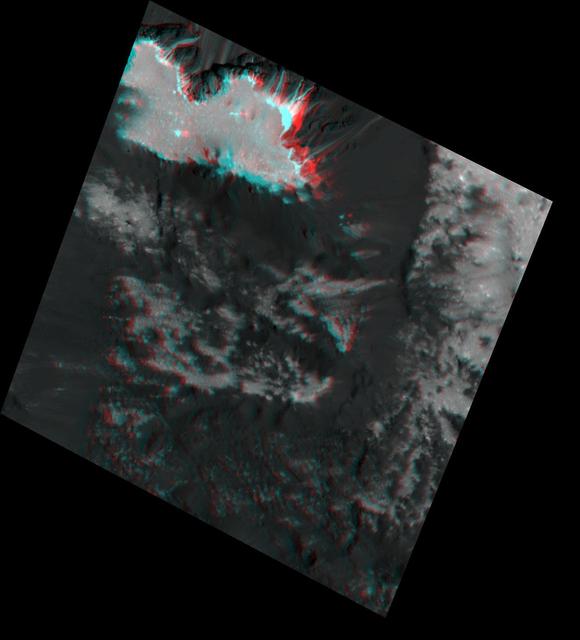
This 3-D image, or anaglyph, shows the center of Occator Crater, the brightest area on dwarf planet Ceres, using data from NASA's Dawn mission. The bright central area, including a dome that is 0.25 miles (400 meters) high, is called Cerealia Facula. The secondary, scattered bright areas are called Vinalia Faculae. A 2017 study suggests that the central bright area is significantly younger than Occator Crater. Estimates put Cerealia Facula at 4 million years old, while Occator Crater is approximately 34 million years old. The reflective material that appears so bright in this image is made of carbonate salts, according to Dawn researchers. The Vinalia Faculae seem to be composed of carbonates mixed with dark material. http://photojournal.jpl.nasa.gov/catalog/PIA21398
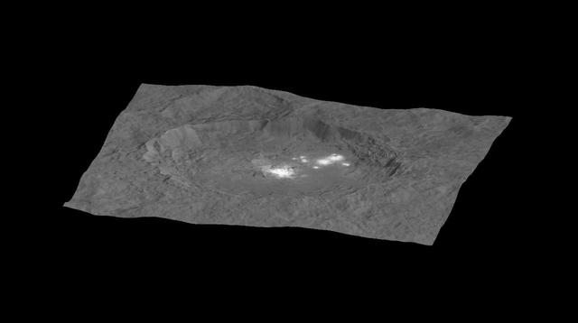
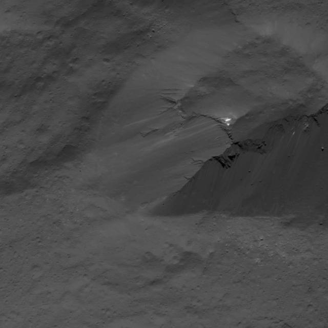
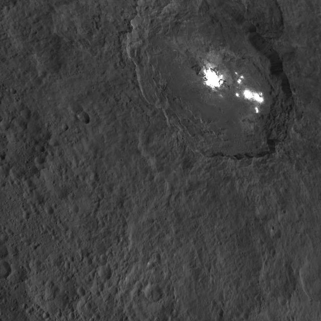
NASA Dawn spacecraft captured Occator Crater, containing the brightest area on Ceres; this closeup reveals a dome in a smooth-walled pit in the bright center of the crater.
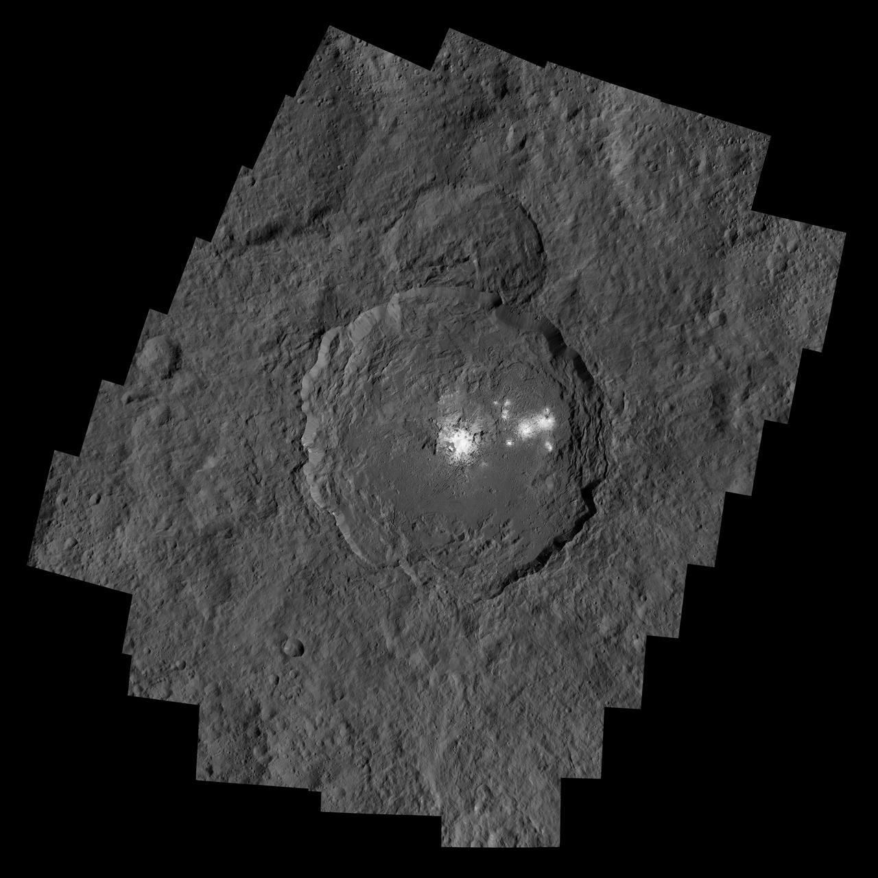
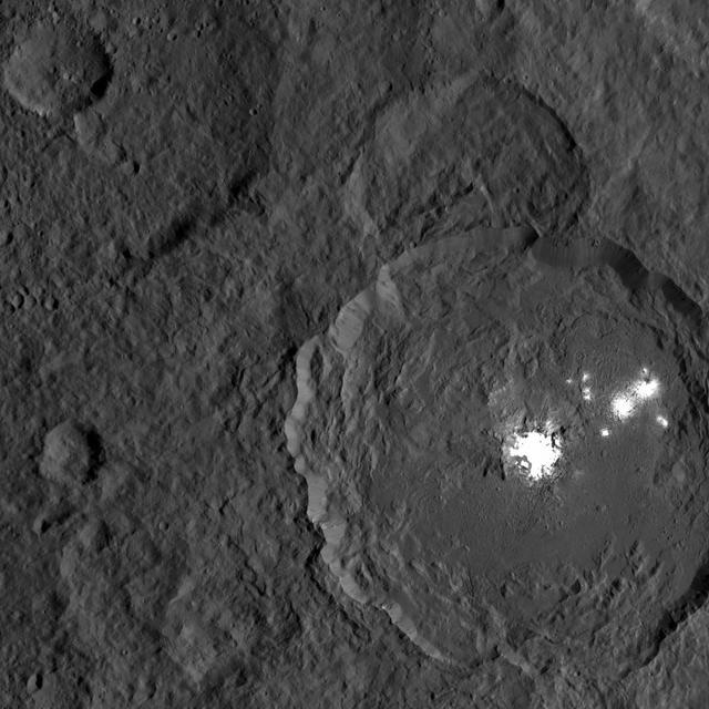
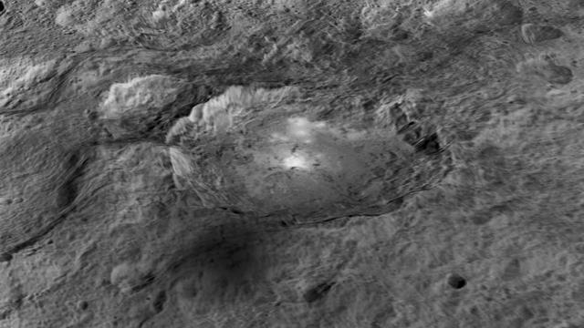
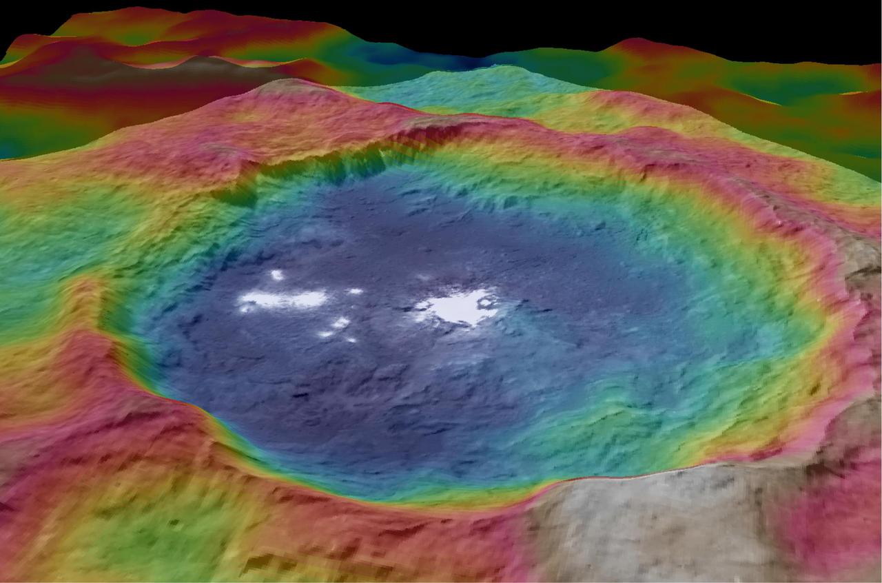
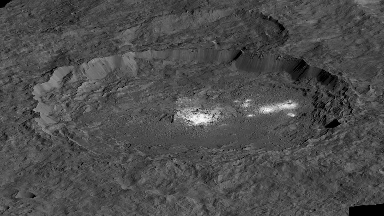
An image of Occator Crater draped over a digital terrain model provides a 3-D-like perspective view of the impact structure. Several bright areas can be seen in this crater. The inner part of the crater forms a type of "crater within a crater" measuring about 6 miles (10 kilometers) in diameter and 0.3 miles (0.5 miles) in depth, and contains the brightest material on all of Ceres. Occator measures about 60 miles (90 kilometers) wide. With its sharp rim and walls, and abundant terraces and landslide deposits, Occator appears to be among the youngest features on Ceres. Dawn mission scientists estimate its age to be about 78 million years old. http://photojournal.jpl.nasa.gov/catalog/PIA20179
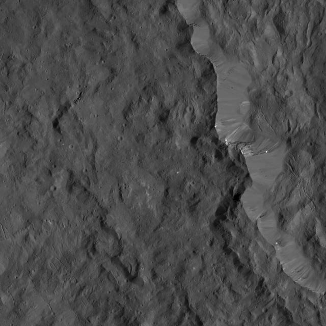
This image of the eastern rim of Occator Crater was obtained by NASA's Dawn spacecraft on June 10, 2018 from an altitude of about 22 miles (36 kilometers). https://photojournal.jpl.nasa.gov/catalog/PIA22529
This image of Ceres' Occator Crater's eastern rim was obtained by NASA's Dawn spacecraft on June 9, 2018 from an altitude of about 30 miles (48 kilometers). https://photojournal.jpl.nasa.gov/catalog/PIA22524
Occator Crater and Ahuna Mons appear together in this view obtained by NASA Dawn spacecraft on Feb. 11, 2017. Ahuna Mons, on the limb at right, is a mountain 2.5 miles (4 kilometers) tall. Occator hosts the mysterious "bright spots" (called faculae) that were revealed by Dawn to be evaporite deposits. Both features are relatively young, share a similar composition -- different from Ceres' average composition -- and hint at recent internal activity in the dwarf planet. Dawn took this image during its third extended-mission science orbit (XMO3), from a distance of about 4,700 miles (7,500 kilometers) above the surface of Ceres. The image resolution is about 2,300 feet (700 meters) per pixel. http://photojournal.jpl.nasa.gov/catalog/PIA11240
This image was obtained by NASA's Dawn spacecraft on July 24, 2018 from an altitude of about 89 miles (143 kilometers). NASA announced the conclusion of Dawn's mission operations was Oct. 31, 2018, when the spacecraft depleted its hydrazine. The center of this feature is located at about 18.5 degrees north latitude and 240.9 degrees east longitude, in the eastern part of Occator Crater. Occator Crater is named after the Roman agricultural deity of the harrowing, a helper of Ceres, the goddess of agriculture, grain crops, fertility and motherly relationships. https://photojournal.jpl.nasa.gov/catalog/PIA22981
This image from NASA's Dawn spacecraft shows Occator Crater on Ceres, with its signature bright areas. Dawn scientists have found that the central bright spot, which harbors the brightest material on Ceres, contains a variety of salts. The brightest parts of these features are overexposed in this image, which had an exposure time intended to capture details in the surrounding terrain. Shorter exposures allow details within the brightest areas to be seen, as in PIA20653. Dawn took this image on Oct. 18, 2016, from its second extended-mission science orbit (XMO2), at a distance of about 920 miles (1,480 kilometers) above the surface. The image resolution is about 460 feet (140 meters) per pixel. http://photojournal.jpl.nasa.gov/catalog/PIA21227

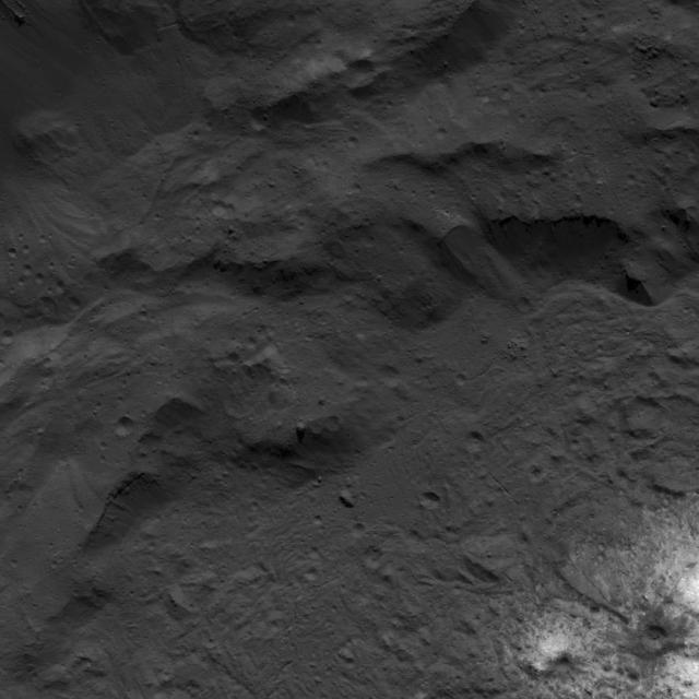
This view across the southeastern floor of the large Occator Crater on the dwarf planet Ceres, in the main asteroid belt between Mars and Jupiter, is based on images obtained during NASA's Dawn spacecraft second extended mission in 2018. The southern rim in the distance rises 2 miles (3.5 kilometers) above the floor. These images were obtained from altitudes between 22 and 31 miles (35 and 50 kilometers.) Occator Crater is 57 miles (92 kilometers) across. Bright pits and mounds in the foreground were formed by salty liquid released during the freezing of the water-rich floor, following the crater-forming impact about 20 million years ago. These features are a few miles across. This area shown here is 6 miles (about 10 kilometers) wide in the foreground and 12 miles (about 20 kilometers) in the background. This image was produced by Paul Schenk at the Lunar and Planetary Institute in Houston. https://photojournal.jpl.nasa.gov/catalog/PIA24022
This image of landslides along Ceres' Occator Crater's eastern rim was obtained by NASA's Dawn spacecraft on June 9, 2018 from an altitude of about 27 miles (44 kilometers). https://photojournal.jpl.nasa.gov/catalog/PIA22526
This image of Occator Crater's southeastern wall and floor was obtained by NASA's Dawn spacecraft on June 17, 2018 from an altitude of about 22 miles (36 kilometers). The center of this picture is located at about 17.4 degrees north latitude and 243.8 degrees east longitude. https://photojournal.jpl.nasa.gov/catalog/PIA22551
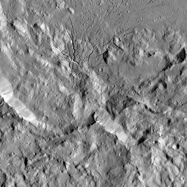
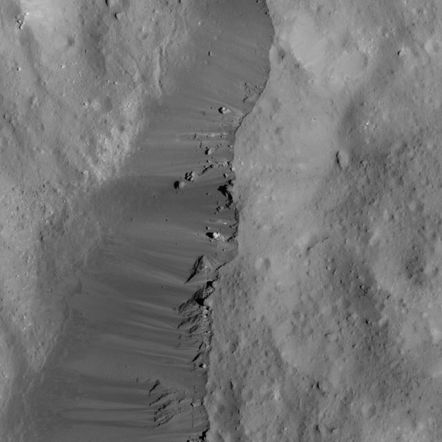
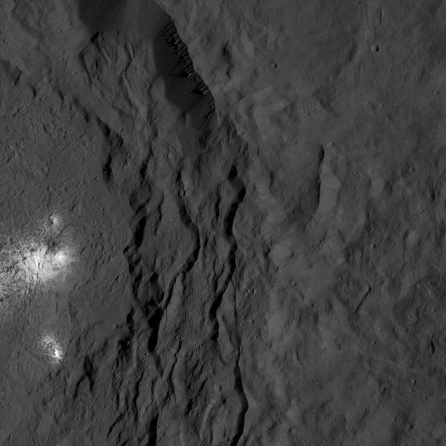
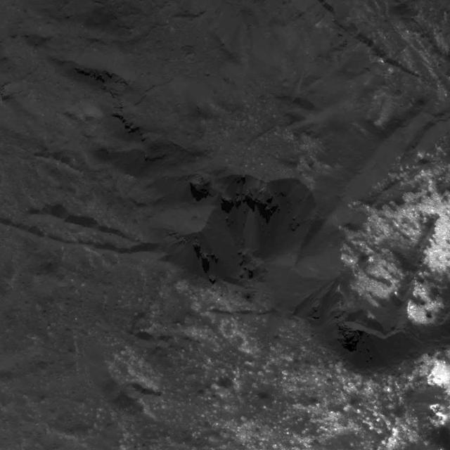
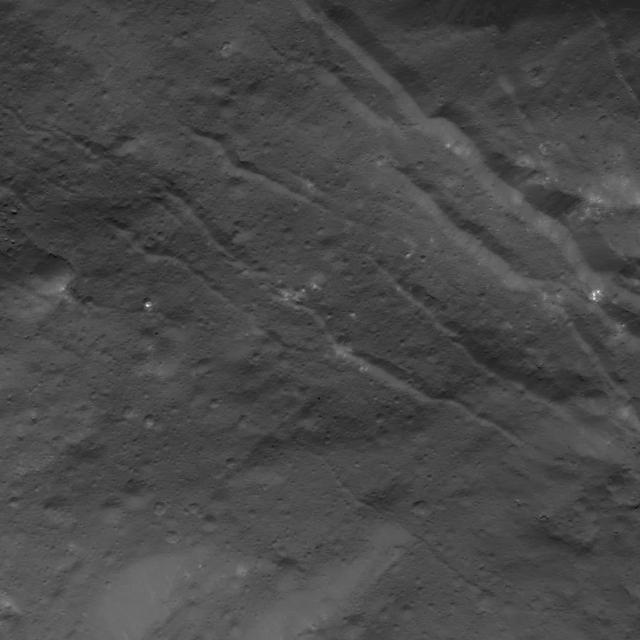
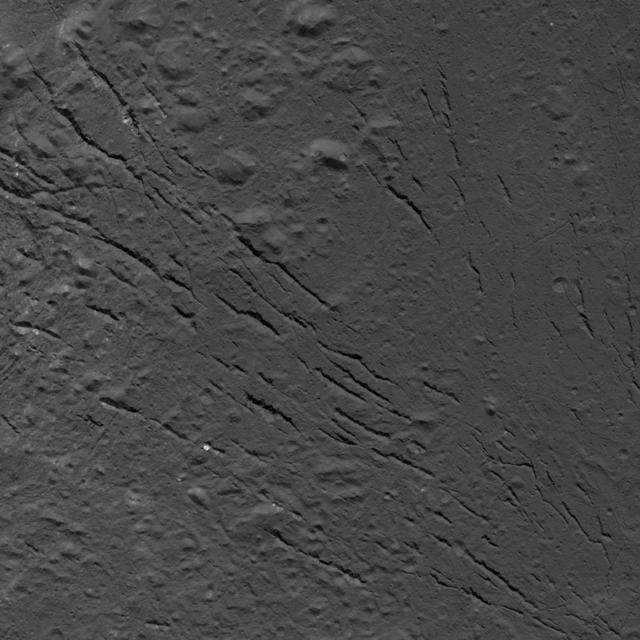
This image shows a complex set of fractures found in the southwestern region of the floor of Occator Crater on Ceres. In this picture, north is at the top. The two intersecting fracture systems (roughly northwest-southeast and southwest-northeast) are part of a larger fault network that extends across Occator's floor. These fractures have been interpreted as evidence that material came up from below and formed a dome shape, as if a piston was pushing Occator's floor from beneath the surface. This may be due to the upwelling of material coming from Ceres' deep interior. An alternative hypothesis is that the deformation is due to volume changes inside a reservoir of icy magma in the shallow subsurface that is in the process of freezing, similar to the change in volume that a bottle of water experiences when put in a freezer. Another set of fractures can be seen parallel to the southwestern wall and is not connected to the Occator fracture network. Dawn took this image during its extended mission on August 17, 2016, from its low-altitude mapping orbit, at a distance of about 240 miles (385 kilometers) above the surface. The image resolution is 120 feet (35 meters) per pixel. The center coordinates are 16 degrees north in latitude and 237 east in longitude. https://photojournal.jpl.nasa.gov/catalog/PIA22091
This image of a boulder field near Ceres' Occator Crater's eastern rim was obtained by NASA's Dawn spacecraft on June 9, 2018 from an altitude of about 30 miles (48 kilometers). https://photojournal.jpl.nasa.gov/catalog/PIA22525
The intriguing brightest spots on Ceres lie in a crater named Occator, which is about 60 miles (90 kilometers) across and 2 miles (4 kilometers) deep. This image comes from an animation, shown in PIA19619, generated using data from NASA's Dawn spacecraft. Vertical relief has been exaggerated by a factor of five. Exaggerating the relief helps scientists understand and visualize the topography much more easily, and highlights features that are sometimes subtle. http://photojournal.jpl.nasa.gov/catalog/PIA19617
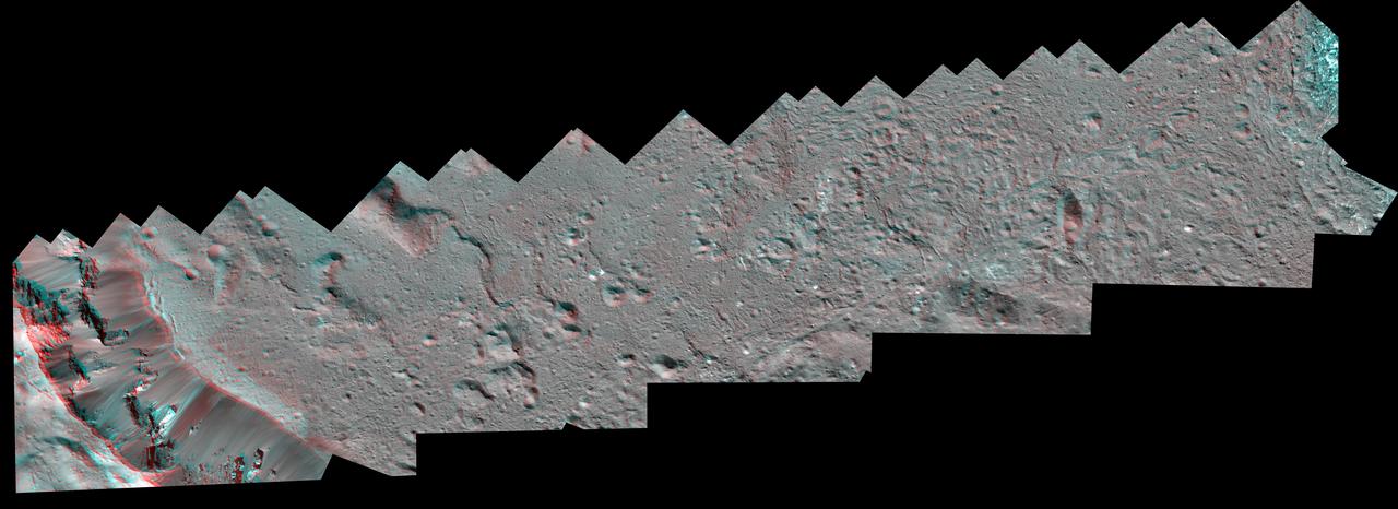
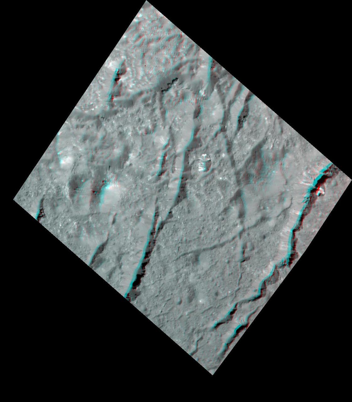
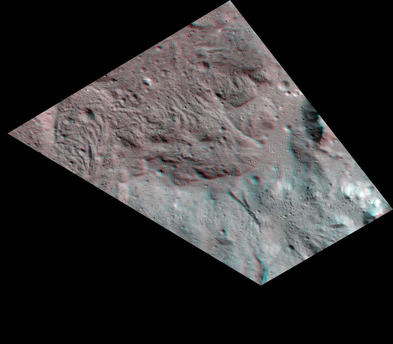
The Dawn spacecraft captured these stereo views of Occator Crater on the dwarf planet Ceres in 2018. More than 70 framing camera images were used to construct this anaglyph view (which requires red-blue stereo glasses for viewing) of the southeastern floor of the crater, including the rim at far left in this view. This area is largely covered with impact melt and features a variety of pits and low mounds, some of which are related to impact debris but others to subsurface brine seepage and deposition. The spatial resolution of the stereo images is about 11 feet (3.5 meters) per pixel. Occator Crater, named after the Roman god of the agricultural practice of harrowing, is about 57 miles (92 kilometers) in diameter. The conclusion of Dawn's mission operations was Oct. 31, 2018, when the spacecraft depleted its hydrazine used for attitude control. This image was produced by Dr. Paul Schenk at the Lunar and Planetary Institute in Houston. https://photojournal.jpl.nasa.gov/catalog/PIA24061

This image was obtained by NASA's Dawn spacecraft on August 14, 2018 from an altitude of about 1149 miles (1849 kilometers). The center of Occator Crater seen near the limb is located at about 19.8 degrees north latitude and 239.3 degrees east longitude. https://photojournal.jpl.nasa.gov/catalog/PIA22764
The Dawn spacecraft captured these stereo images of Occator Crater on the dwarf planet Ceres in 2018. Framing camera images were used to construct this anaglyph view (which requires red-blue stereo glasses for viewing) of part of the southeastern floor of the crater. This area is approximately 3 miles (5 kilometers) wide and is entirely within the large impact melt deposit formed there during the impact process. The low bright mounds and pits were probably formed by brine that moved to the surface to form surface vents and surface domes during freezing. The spatial resolution of the stereo images is about 11 feet (3.5 meters) per pixel. Occator crater, named after the Roman god of the agricultural practice of harrowing, is about 57 miles (92 kilometers) in diameter. The conclusion of Dawn's mission operations was Oct. 31, 2018, when the spacecraft depleted its hydrazine used for attitude control. This image was produced by Dr. Paul Schenk at the Lunar and Planetary Institute in Houston. https://photojournal.jpl.nasa.gov/catalog/PIA24062
The Dawn spacecraft captured these stereo images of Occator crater on the dwarf planet Ceres in 2018. Framing camera images were used to construct this anaglyph view (which requires red-blue stereo glasses for viewing) of part of the northeastern rim of the crater. This area is approximately 4 miles (7 kilometers) wide and features a thin mantling layer of impact melt draped over faulted terrace blocks. Impact melt flowed through a gap in the blocks in the center of the frame. The spatial resolution of the stereo images is about 11 feet (3.5 meters) per pixel. Occator Crater, named after the Roman god of the agricultural practice of harrowing, is about 57 miles (92 kilometers) in diameter. The conclusion of Dawn's mission operations was Oct. 31, 2018, when the spacecraft depleted its hydrazine used for attitude control. This image was produced by Dr. Paul Schenk at the Lunar and Planetary Institute in Houston. https://photojournal.jpl.nasa.gov/catalog/PIA24064

This frame from a video from NASA's Dawn mission shows dwarf planet Ceres in false-color renderings, which highlight differences in surface materials. Images were used to create a movie of Ceres rotating, followed by a flyover view of Occator Crater, home of Ceres' brightest area. A video is available at http://photojournal.jpl.nasa.gov/catalog/PIA20182

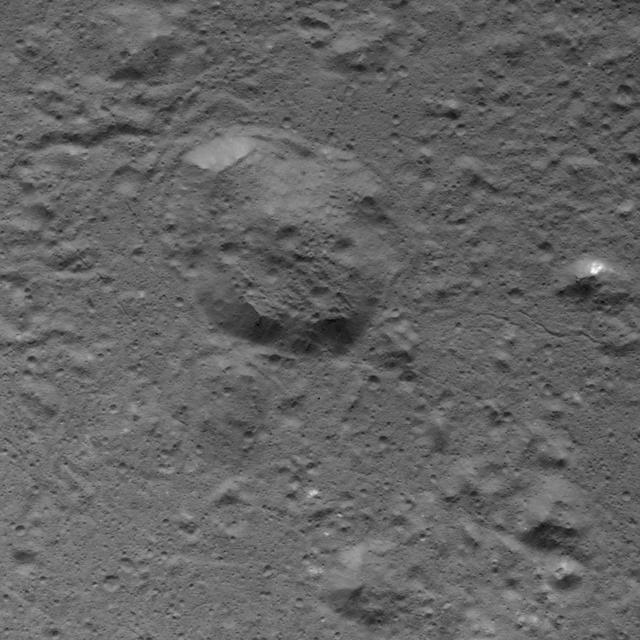
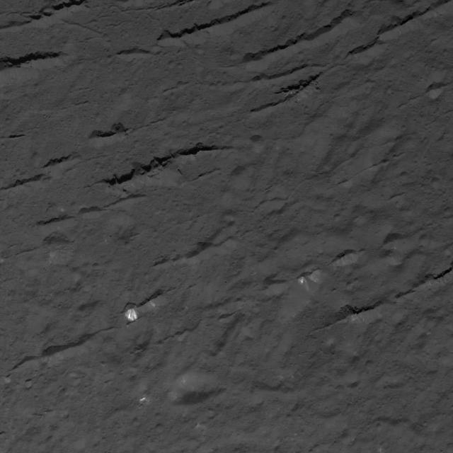
This picture captured by NASA Dawn spacecraft shows a crater that lies just north of Occator Crater, home of the brightest spots on Ceres. The northern rim of Occator, not visible here, is overprinted on the southern rim this crater.
The Dawn spacecraft captured these stereo images of Occator Crater on the dwarf planet Ceres in 2018. This view is part of a mosaic of about 50 framing camera images used to construct this anaglyph view (which requires red-blue stereo glasses for viewing) of part of the eastern floor of the crater. This area is approximately 5 miles (8.5 kilometers) wide and features bright carbonate deposits of the Vinalia Faculae formation on top of the ropey textured lobate floor impact melt deposit. Stereo views of Vinalia Faculae illustrate the complex relationship between the thin carbonates and the underlying impact deposits. The spatial resolution of the stereo images is about 11 feet (3.5 meters) per pixel. Occator crater, named after the Roman god of the agricultural practice of harrowing, is about 57 miles (92 kilometers) in diameter. The conclusion of Dawn's mission operations was Oct. 31, 2018, when the spacecraft depleted its hydrazine used for attitude control. This image was produced by Dr. Paul Schenk at the Lunar and Planetary Institute in Houston. https://photojournal.jpl.nasa.gov/catalog/PIA24063
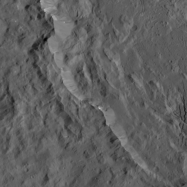
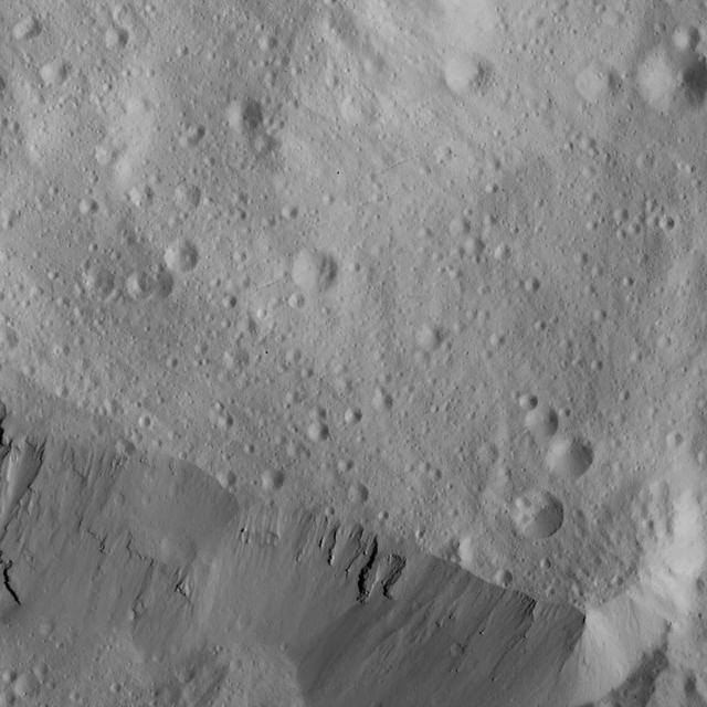
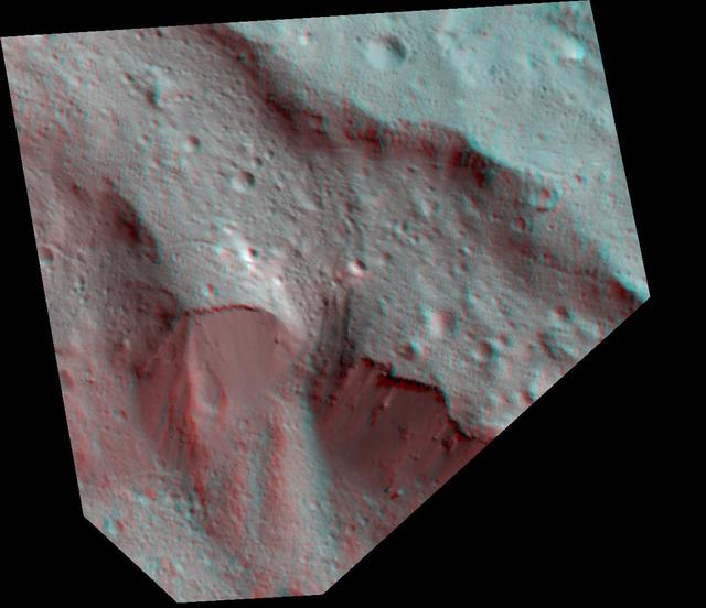
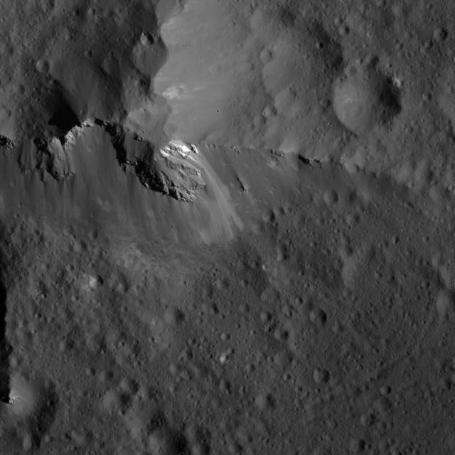
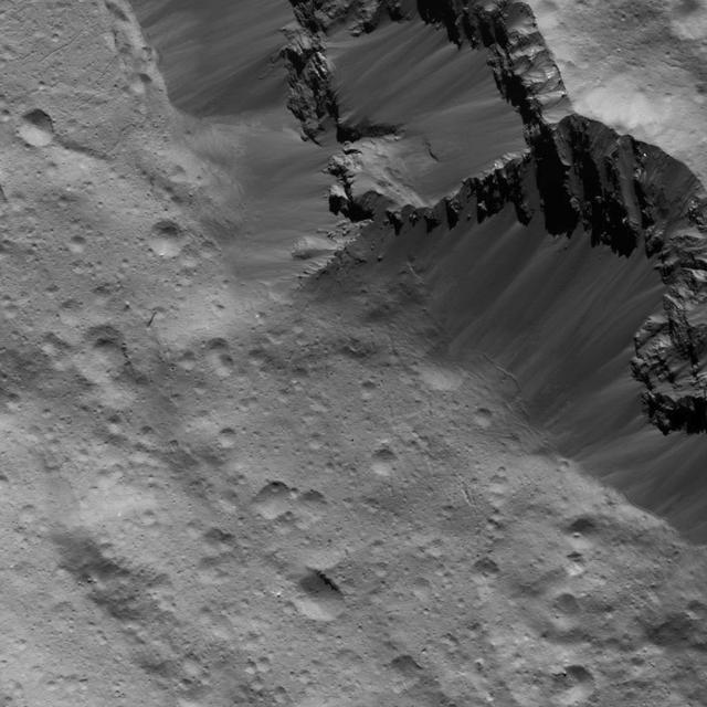
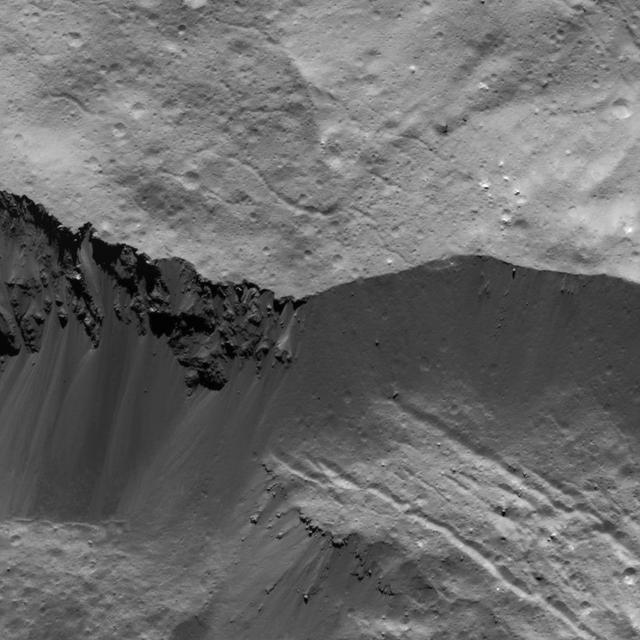
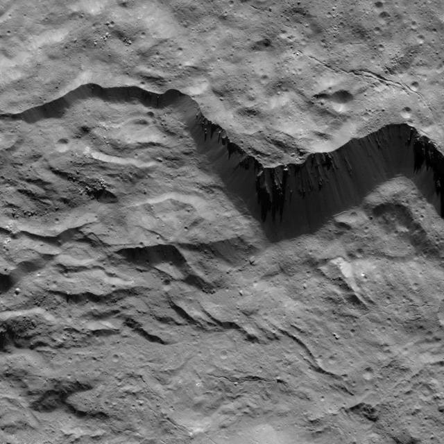
A portion of the rugged rim of Occator Crater is seen in this image from NASA's Dawn spacecraft. Occator, a young crater approximately 80 million years old, is home to the brightest area on Ceres (not pictured here). Bright streaks are visible along some of the crater's walls, along with prominent fractures on the crater floor. Dawn took this image on April 21, 2016, from its low-altitude mapping orbit, at a distance of about 240 miles (385 kilometers) above the surface. The image resolution is 120 feet (35 meters) per pixel. http://photojournal.jpl.nasa.gov/catalog/PIA20823
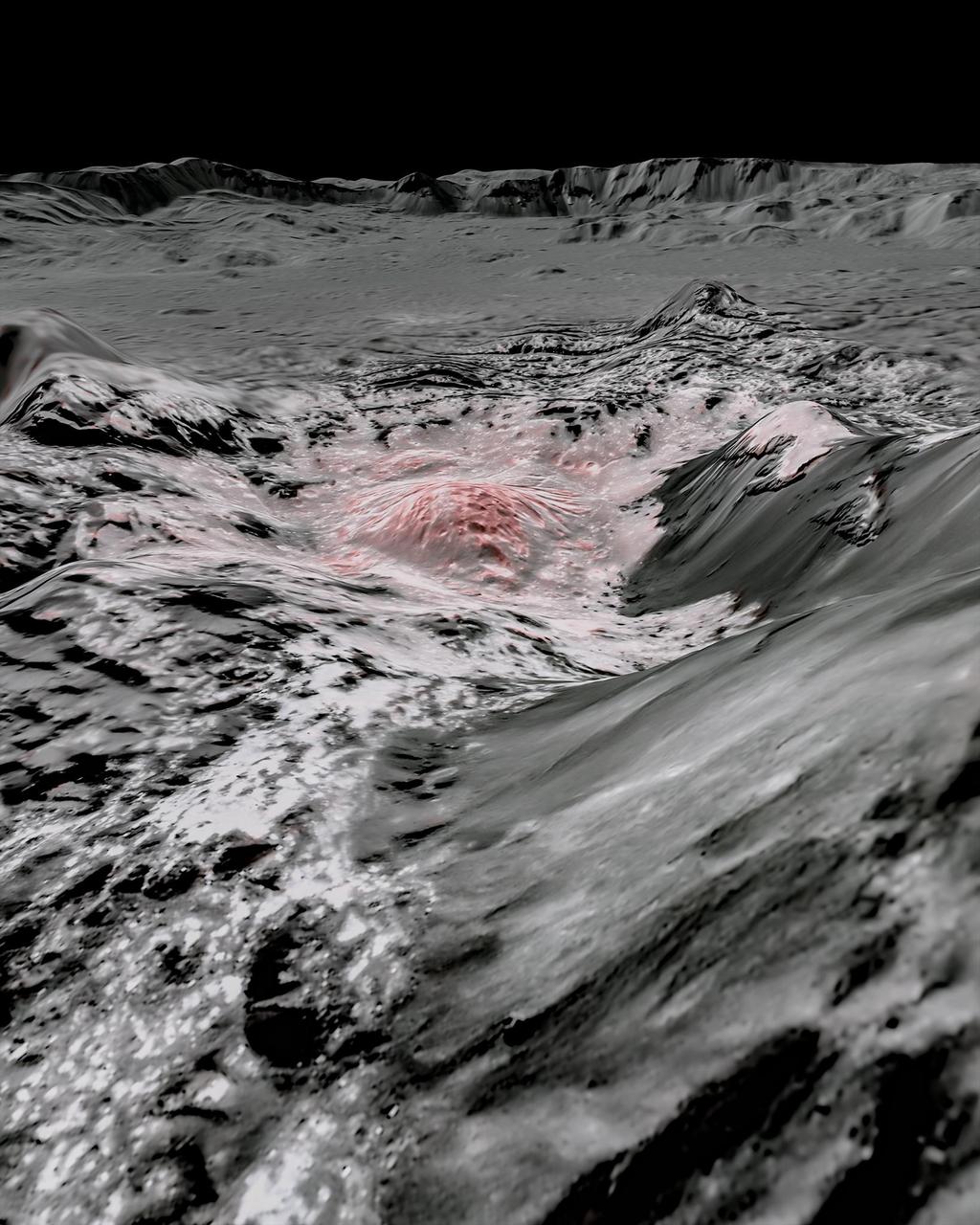
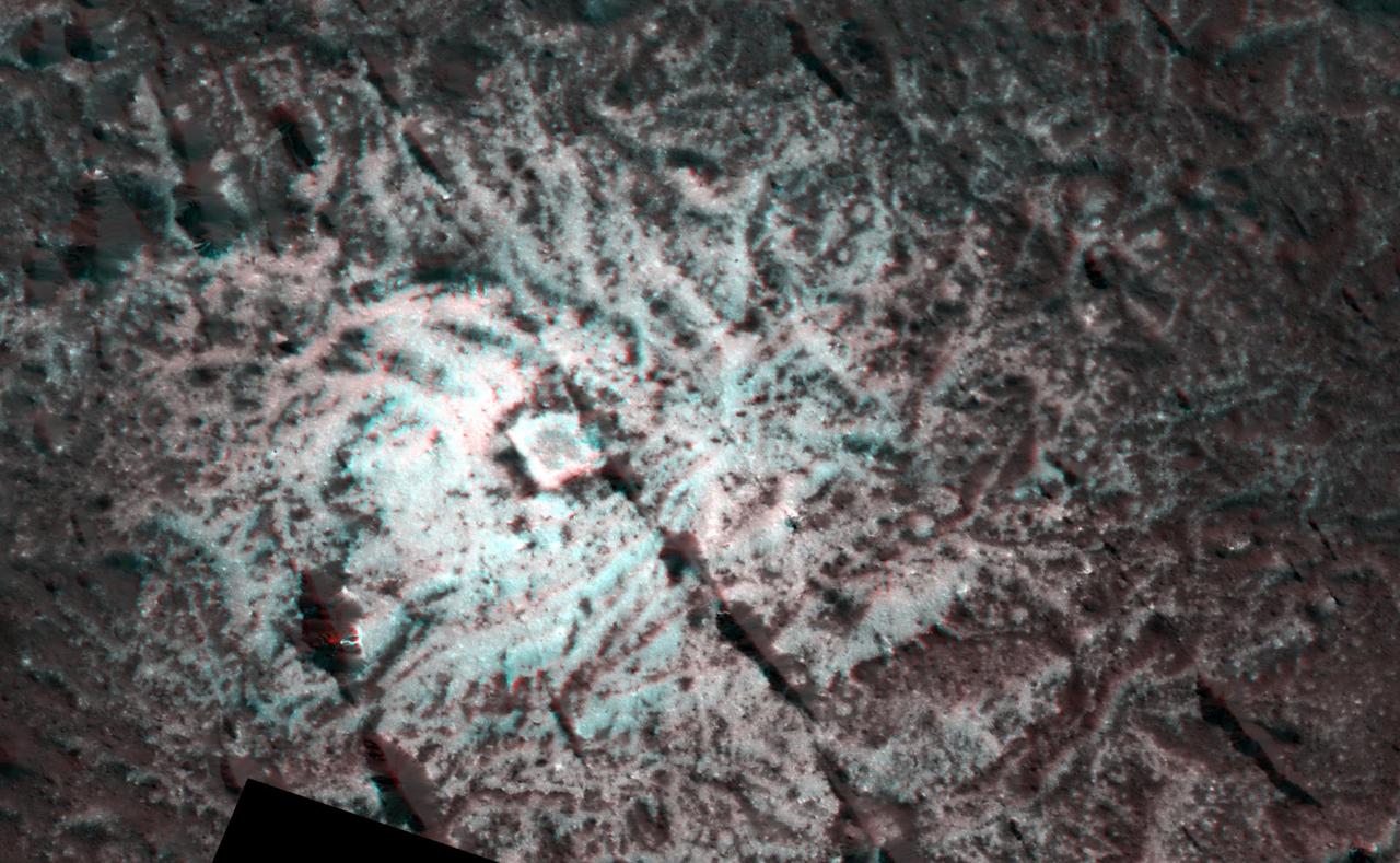
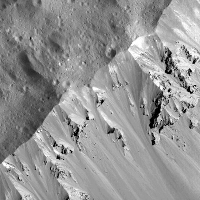
NASA's Dawn spacecraft captured pictures in visible and infrared wavelengths, which were combined to create this false-color view of a region in 57-mile-wide (92-kilometer-wide) Occator Crater on the dwarf planet Ceres (in the main asteroid belt between Mars and Jupiter). Here, recently exposed brine, or salty liquids, in the center of the crater were pushed up from a deep reservoir below Ceres' crust. In this view, they appear reddish. In the foreground, is Cerealia Facula ("facula" means bright area), a 9-mile-wide (15-kilometer-wide) region with a composition dominated by salts. The central dome, Cerealia Tholus, is about 1.9 miles (3 kilometers) across at its base and 1,100 feet (340 meters) tall. The dome is inside a central depression about 3,000 feet (900 meters) deep. The area depicted in this scene is about 1.3 miles (2.1 kilometers) wide in the foreground, about 7 miles (11 kilometers) wide across the dome, and 35 miles (56 kilometers) wide in the background, where the crater rim rises against the black sky. The distance from the near point (at the bottom) to the far point (at the top) is about 32 miles (52 kilometers). This mosaic is made from multiple images Dawn captured during its second extended mission in 2018 from an altitude of about 22 miles (35 kilometers). Those were combined with a topographic map based on images obtained during Dawn's prime mission and first extended mission in 2016, from an altitude of about 240 miles (385 kilometers). The resolution varies from about 11 feet (3.5 meters) per pixel in the bright regions to about 115 feet (35 meters) per pixel in the background. The color data that is overlain on the topographic data was obtained during the prime mission in 2015 when the spacecraft was at an altitude of 915 miles (1470 kilometers). It has a resolution of 450 feet (140 meters) per pixel. https://photojournal.jpl.nasa.gov/catalog/PIA24021
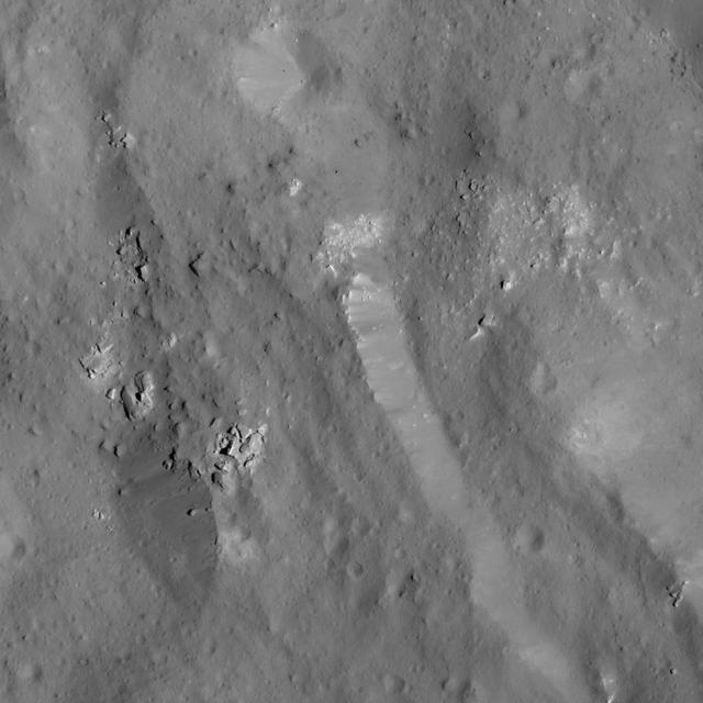
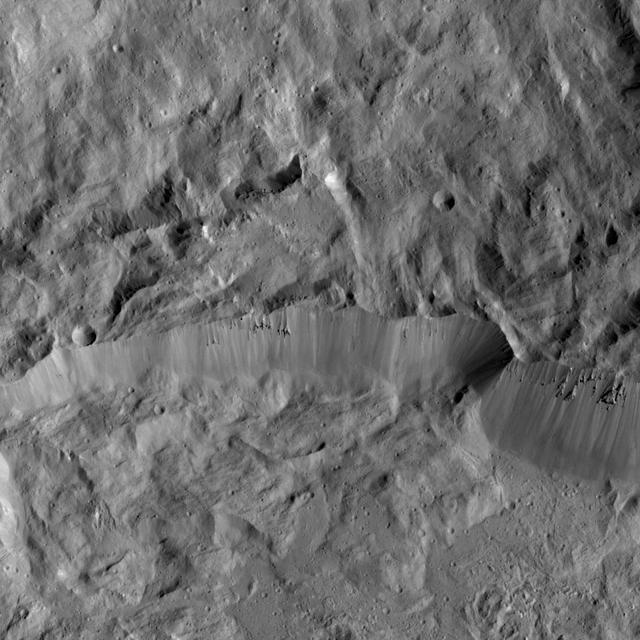
This image, taken by NASA Dawn spacecraft, shows the southeastern rim of Occator Crater. Compacted material forms spurs along the crater wall. A group of roughly parallel, braided fractures can be seen on the crater floor at top center.
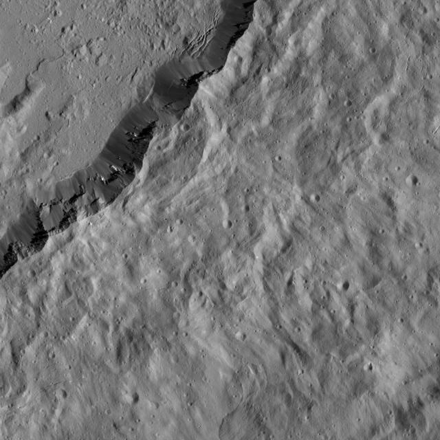
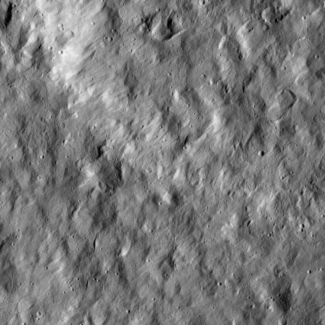
NASA's Dawn spacecraft imaged this terrain, adjacent to Occator Crater on Ceres, which is immediately to the left of this view. This relatively smooth, lightly cratered area is part of the ejecta blanket of Occator -- material thrown out by the force of the impact that created the crater, approximately 80 million years ago. Dawn took this image on April 18, 2016, from its low-altitude mapping orbit, at a distance of about 240 miles (385 kilometers) above the surface. The image resolution is 120 feet (35 meters) per pixel. http://photojournal.jpl.nasa.gov/catalog/PIA20817

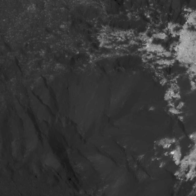
This image from NASA Dawn spacecraft shows the rim of Occator crater, just east of the area containing the brightest spots on Ceres. The crater rim has collapsed, leaving structures geologists refer to as terraces.
This view from NASA Dawn spacecraft shows a scene from the northern hemisphere of Ceres, north of Occator Crater, which is home of the brightest area on the dwarf planet.
This image from NASA Dawn spacecraft shows the western rim of Occator Crater. Several small, bright patches of material can be seen along the rim.
This frame from a movie shows that the brightest area on Ceres, located in Occator Crater, was one of the last features to be imaged as NASA Dawn progressively built its map.
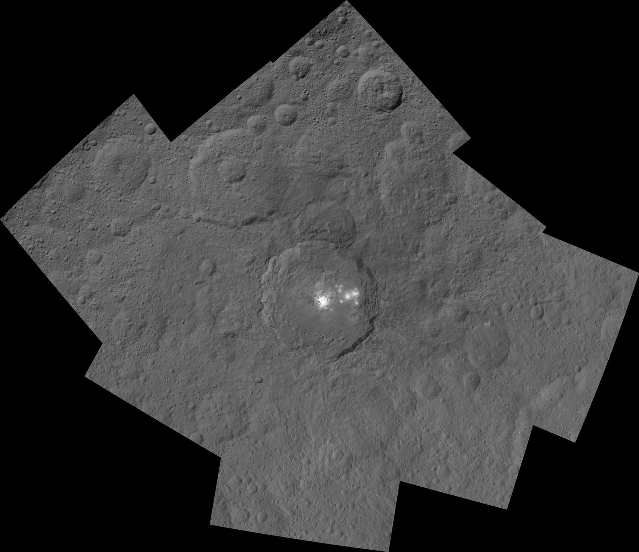
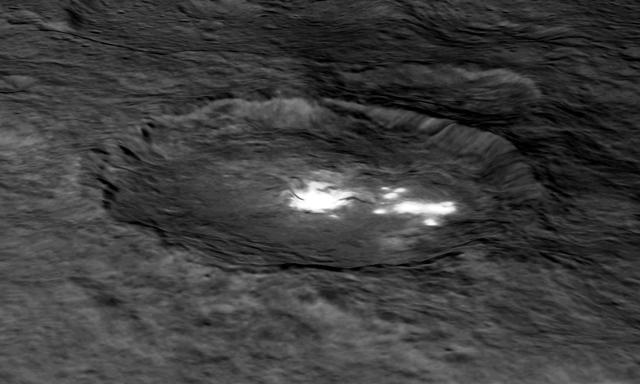
This mosaic shows Ceres' Occator crater and surrounding terrain from an altitude of 915 miles (1,470 kilometers), as seen by NASA's Dawn spacecraft. Occator is 60 miles (90 kilometers) across and 2 miles (4 kilometers) deep. Occator is home to the brightest area on Ceres, which tends to appear overexposed in most images. This view uses a composite of two images of Occator: one using a short exposure that captures the detail in the bright spots, and one where the background surface is captured at normal exposure. The images used to make this mosaic have a resolution of 450 feet (140 meters) per pixel, and were taken during the first of six mapping cycles during Dawn's high-altitude mapping orbit. http://photojournal.jpl.nasa.gov/catalog/PIA19996
A group of scientists from NASA's Dawn mission suggests that when sunlight reaches Ceres' Occator Crater, a kind of thin haze of dust and evaporating water forms there. This haze only becomes dense enough to be seen by looking at it laterally, as in this image, the scientists wrote in the journal Nature in December 2015. Occator measures about 60 miles (90 kilometers) wide, and contains the brightest material seen on Ceres. http://photojournal.jpl.nasa.gov/catalog/PIA20181
This view, made using images taken by NASA Dawn spacecraft, is a color-coded topographic map of Occator crater on Ceres. Blue is the lowest elevation, and brown is the highest. http://photojournal.jpl.nasa.gov/catalog/PIA19975

This photo of Ceres and the bright regions in Occator Crater was one of the last views NASA's Dawn spacecraft transmitted before it depleted its remaining hydrazine and completed its mission. This view, which faces south, was captured on Sept. 1, 2018 at an altitude of 2,340 miles (3,370 kilometers) as the spacecraft was ascending in its elliptical orbit. At its lowest point, the orbit dipped down to only about 22 miles (35 kilometers), which allowed Dawn to acquire very high-resolution images in this final phase of its mission. Some of the close-up images of Occator Crater are shown here. Occator Crater is 57 miles (92 kilometers) across and 2.5 miles (4 kilometers) deep and holds the brightest area on Ceres, Cerealia Facula in its center and Vinalia Faculae in its western side. This region has been the subject of intense interest since Dawn's approach to the dwarf planet in early 2015. https://photojournal.jpl.nasa.gov/catalog/PIA22485
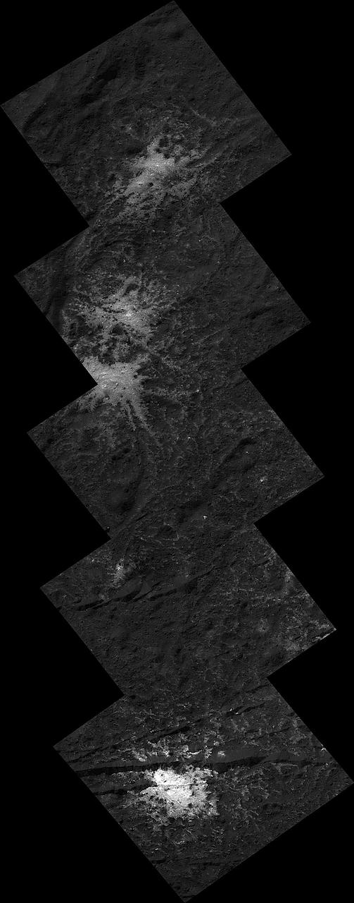
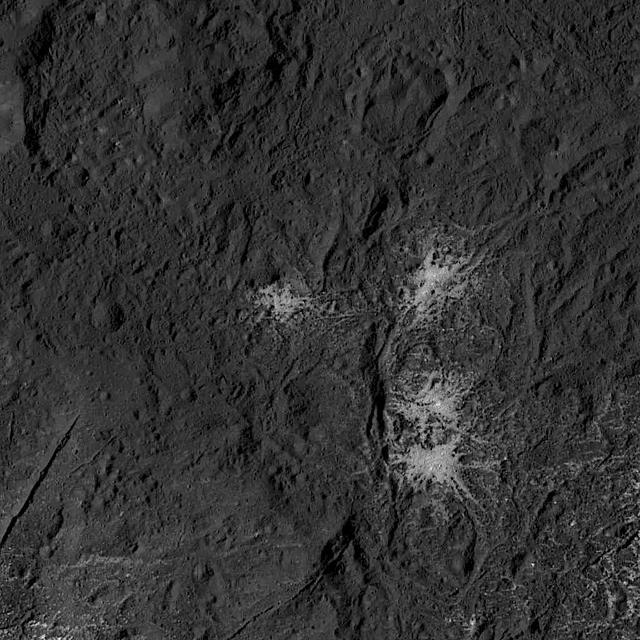
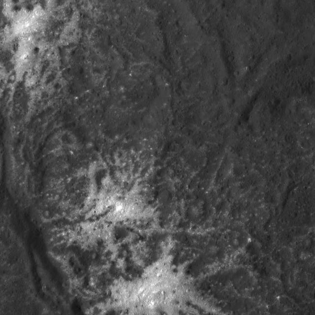
These "stars" found on the floor of Ceres' Occator Crater belong to the Vinalia Faculae. The faculae are deposits of salts, in particular sodium carbonate, possibly extruded through fractures connecting the surface to a deep reservoir of salty liquid. The images used in this montage were obtained by NASA's Dawn spacecraft in June 2018 from an altitude of about 21 miles (34 kilometers). NASA announced the conclusion of Dawn's mission operations was Oct. 31, 2018, when the spacecraft depleted its hydrazine. The center of this feature is located at about 20.2 degrees north latitude and 241.3 degrees east longitude, in the eastern part of Occator Crater. Occator Crater is named after the Roman agricultural deity of the harrowing, a helper of Ceres, the goddess of agriculture, grain crops, fertility and motherly relationships. https://photojournal.jpl.nasa.gov/catalog/PIA22980

This orthographic projection shows dwarf planet Ceres as seen by NASA's Dawn spacecraft. The projection is centered on Occator Crater, home to the brightest area on Ceres. Occator is centered at 20 degrees north latitude, 239 degrees east longitude. This image was made from views Dawn took during its low-altitude mapping orbit, at about 240 miles (385 kilometers) above the surface. The image resolution is about 460 feet (140 meters) per pixel. https://photojournal.jpl.nasa.gov/catalog/PIA21906

NASA Dawn spacecraft sees Occator Crater, home of the brightest area on Ceres, also has an intriguing rim. The jagged slopes of this basin, and linear features on its floor, contrast with the relatively smooth terrain around it.

The iconic bright spots of Occator Crater are seen up close in this image of Ceres. This image from NASA Dawn spacecraft reveals a central dome with linear features on and around it.
This picture shows a portion of the northern rim of Occator Crater, which measures 57 miles (92 kilometers) across and 2.5 miles (4 kilometers) deep. Occator is home to Ceres' brightest spots, not pictured. A view of the entirety of the crater is at PIA20350. The view is centered at approximately 25 degrees north latitude, 240 degrees east longitude. NASA's Dawn spacecraft took this image on April 21, 2016, from its low-altitude mapping orbit, at a distance of about 240 miles (385 kilometers) above the surface. The image resolution is 120 feet (35 meters) per pixel. http://photojournal.jpl.nasa.gov/catalog/PIA20683
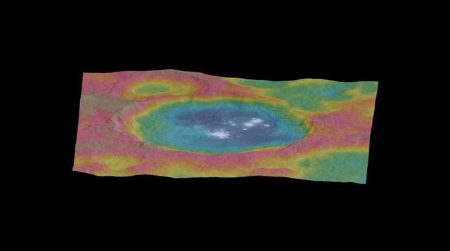
This still from an animation, made using images taken by NASA's Dawn spacecraft, features a color-coded topographic map of Occator crater on Ceres. Elevations span a range of about 4 miles (6 kilometers) from the lowest places in Occator to the highest terrains surrounding the crater. Blue is the lowest elevation, and brown is the highest. The animation was generated using two components: images of the surface taken during Dawn's High Altitude Mapping Orbit (HAMO) phase, where it viewed the surface at a resolution of about 450 feet (140 meters) per pixel, and a shape model generated using images taken at varying sun and viewing angles during Dawn's lower-resolution Survey phase. The shape model, which has been stretched by 1.5 times in the vertical direction to better illustrate the crater's topography. An animation is available is http://photojournal.jpl.nasa.gov/catalog/PIA19891
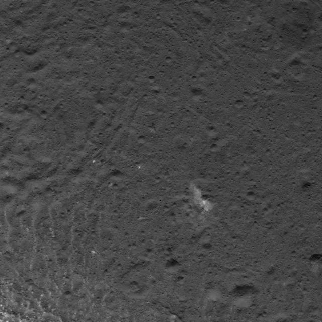
A cluster of bright areas in Ceres Occator Crater are seen in this image from NASA Dawn spacecraft. These areas are not as bright as the material at the center of the crater. Dawn took this image on June 16, 2016, from its low-altitude mapping orbit, at a distance of about 240 miles (385 kilometers) above the surface. The image resolution is 120 feet (35 meters) per pixel. http://photojournal.jpl.nasa.gov/catalog/PIA20831
This still from an animation, made using images taken by NASA's Dawn spacecraft, shows Occator crater on Ceres, home to a collection of intriguing bright spots. The animation was generated using two components: images taken during Dawn's High Altitude Mapping Orbit (HAMO) phase, where it viewed the surface at a resolution of about 450 feet (140 meters) per pixel, and a shape model generated using images that were taken during Dawn's lower-resolution Survey phase. The image is draped over the shape model, which has been stretched by 1.5 times in the vertical direction to better illustrate the crater's topography. Elevations span a range of about 4 miles (6 kilometers) from the lowest places in Occator to the highest terrains surrounding the crater. The bright spots are much brighter than the rest of the surface, and tend to appear overexposed in most images. The image used here is a composite of two images of Occator: one using a short exposure that captures the detail in the bright spots, and one where the background surface is captured at normal exposure. http://photojournal.jpl.nasa.gov/catalog/PIA19890
This image was obtained by NASA's Dawn spacecraft on July 31, 2018 from an altitude of about 31 miles (50 kilometers). The center of this picture is located at about 45.4 degrees south latitude and 252.8 degrees east longitude. https://photojournal.jpl.nasa.gov/catalog/PIA22762
This image was obtained by NASA's Dawn spacecraft on July 5, 2018 from an altitude of about 32 miles (51 kilometers). The center of this picture is located at about 18.8 degrees north latitude and 240.7 degrees east longitude. https://photojournal.jpl.nasa.gov/catalog/PIA22632
This image was obtained by NASA's Dawn spacecraft on July 6, 2018 from an altitude of about 72 miles (116 kilometers). The center of this picture is located at about 44.1 degrees south latitude and 249.1 degrees east longitude. https://photojournal.jpl.nasa.gov/catalog/PIA22628
This image was obtained by NASA's Dawn spacecraft on July 3, 2018 from an altitude of about 26 miles (42 kilometers). The center of this picture is located at about 16.5 degrees north latitude and 241.2 degrees east longitude. https://photojournal.jpl.nasa.gov/catalog/PIA22640
This image was obtained by NASA's Dawn spacecraft on July 5, 2018 from an altitude of about 34 miles (55 kilometers). The center of this picture is located at about 20.9 degrees north latitude and 240.5 degrees east longitude. https://photojournal.jpl.nasa.gov/catalog/PIA22629
This image was obtained by NASA's Dawn spacecraft on July 3, 2018 from an altitude of about 22 miles (35 kilometers). The center of this picture is located at about 14.4 degrees north latitude and 241.4 degrees east longitude. https://photojournal.jpl.nasa.gov/catalog/PIA22634
This image was obtained by NASA's Dawn spacecraft on July 3, 2018 from an altitude of about 28 miles (44 kilometers). The center of this picture is located at about 18.0 degrees north latitude and 238.0 degrees east longitude. https://photojournal.jpl.nasa.gov/catalog/PIA22639
This image was obtained by NASA's Dawn spacecraft on July 6, 2018 from an altitude of about 72 miles (116 kilometers). The center of this picture is located at about 44.1 degrees south latitude and 249.1 degrees east longitude. https://photojournal.jpl.nasa.gov/catalog/PIA22627
This image of Occator Crater's northern wall was obtained by NASA's Dawn spacecraft on June 16, 2018 from an altitude of about 21 miles (33 kilometers). The sub-spacecraft position from which this image was taken is about 25.8 degrees north latitude and 242.1 degrees east longitude. https://photojournal.jpl.nasa.gov/catalog/PIA22550

This image taken by NASA's Dawn spacecraft, shows Occator crater on Ceres, home to a collection of intriguing bright spots. The bright spots are much brighter than the rest of Ceres' surface, and tend to appear overexposed in most images. This view is a composite of two images of Occator: one using a short exposure that captures the detail in the bright spots, and one where the background surface is captured at normal exposure. The images were obtained by Dawn during the mission's High Altitude Mapping Orbit (HAMO) phase, from which the spacecraft imaged the surface at a resolution of about 450 feet (140 meters) per pixel. http://photojournal.jpl.nasa.gov/catalog/PIA19889
This image, taken by NASA's Dawn spacecraft, shows the bright spots of Occator crater on Ceres from an altitude of 2,700 miles (4,400 kilometers). The image, with a resolution of 1,400 feet (410 meters) per pixel, was taken on June 25, 2015. http://photojournal.jpl.nasa.gov/catalog/PIA19630
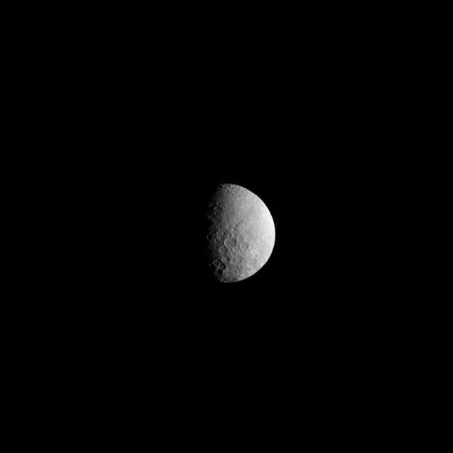
One of the most intriguing features on Ceres, Occator crater, is seen in this oblique view from NASA's Dawn spacecraft. This crater is 60 miles (90 kilometers) across and 2 miles (4 kilometers) deep, and is home to the brightest areas on Ceres. This image was acquired from an altitude of 915 miles (1,470 kilometers). Dawn took this image on Oct. 18, 2015. http://photojournal.jpl.nasa.gov/catalog/PIA20132

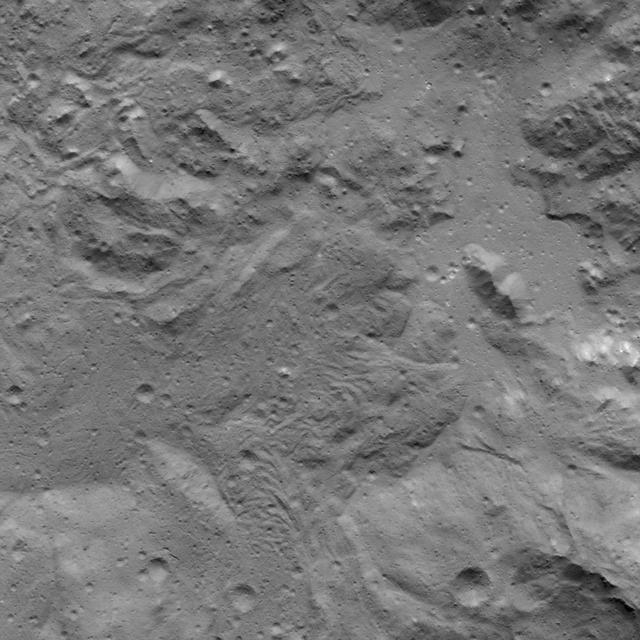
This image from NASA Dawn spacecraft shows a portion of Ceres known as Erntedank Planum, a broad plateau 345 miles 555 kilometers wide. The terrain seen here lies just to the southeast of Occator Crater, home of Ceres brightest region.
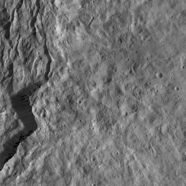
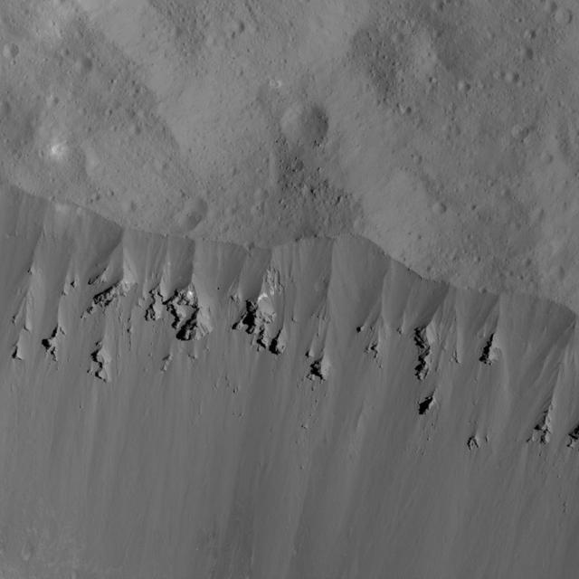
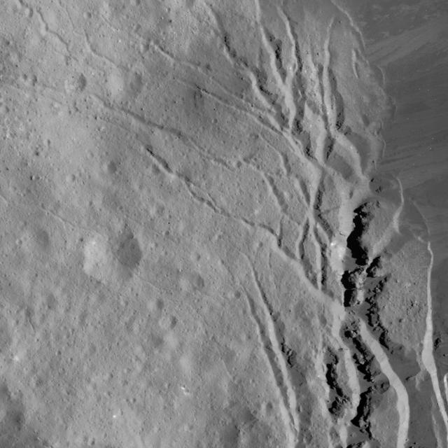
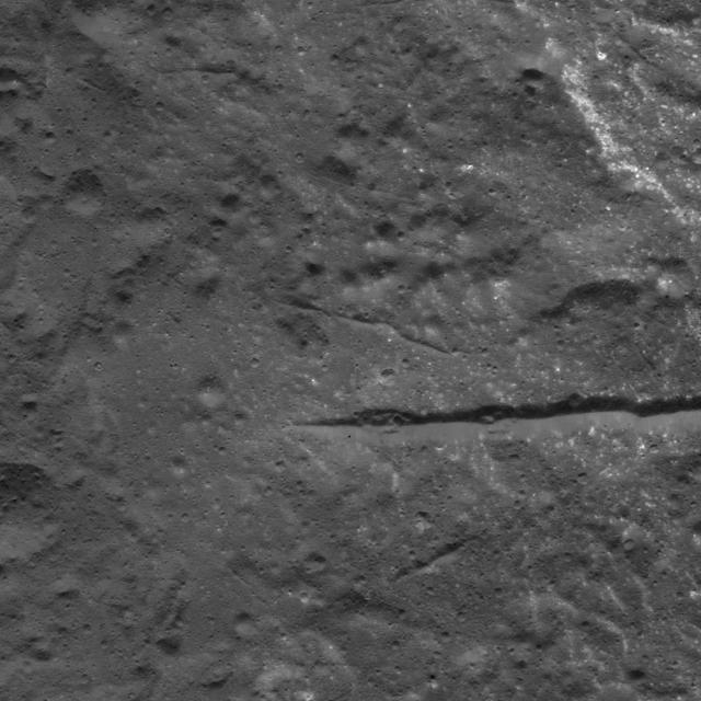
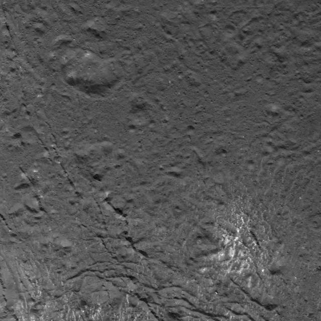
This view from NASA's Dawn spacecraft features the rugged rim of Occator Crater at left. A number of thin fractures are visible, roughly parallel to the rim. Dawn took this image on April 18, 2016, from its low-altitude mapping orbit, at a distance of about 240 miles (385 kilometers) above the surface. The image resolution is 120 feet (35 meters) per pixel. http://photojournal.jpl.nasa.gov/catalog/PIA20818
This image was obtained by NASA's Dawn spacecraft on July 5, 2018 from an altitude of about 32 miles (52 kilometers). The center of this picture is located at about 19.3 degrees north latitude and 240.7 degrees east longitude. https://photojournal.jpl.nasa.gov/catalog/PIA22631
This image was obtained by NASA's Dawn spacecraft on July 16, 2018 from an altitude of about 67 miles (107 kilometers). The center of this picture is located at about 22.3 degrees north latitude and 240.3 degrees east longitude. https://photojournal.jpl.nasa.gov/catalog/PIA22642
This image was obtained by NASA's Dawn spacecraft on July 16, 2018 from an altitude of about 58 miles (93 kilometers). The center of this picture is located at about 18.5 degrees north latitude and 240.9 degrees east longitude. https://photojournal.jpl.nasa.gov/catalog/PIA22757
This image was obtained by NASA's Dawn spacecraft on July 16, 2018 from an altitude of about 47 miles (76 kilometers). The center of this picture is located at about 14.7 degrees north latitude and 241.5 degrees east longitude. https://photojournal.jpl.nasa.gov/catalog/PIA22643
This image was obtained by NASA's Dawn spacecraft on July 25, 2018 from an altitude of about 87 miles (140 kilometers). The center of this picture is located at about 16.4 degrees north latitude and 238.9 degrees east longitude. https://photojournal.jpl.nasa.gov/catalog/PIA22760
This image was obtained by NASA's Dawn spacecraft on July 4, 2018 from an altitude of about 30 miles (48 kilometers). The center of this picture is located at about 18.5 degrees north latitude and 240.5 degrees east longitude. https://photojournal.jpl.nasa.gov/catalog/PIA22637
This image was obtained by NASA's Dawn spacecraft on July 26, 2018 from an altitude of about 94 miles (152 kilometers). The center of this picture is located at about 16.9 degrees north latitude and 237.5 degrees east longitude. https://photojournal.jpl.nasa.gov/catalog/PIA22761
his image was obtained by NASA's Dawn spacecraft on July 1, 2018 from an altitude of about 29 miles (46 kilometers). The center of this picture is located at about 20.8 degrees north latitude and 241.2 degrees east longitude. https://photojournal.jpl.nasa.gov/catalog/PIA22644

This image from NASA's Dawn spacecraft shows Dantu Crater, which is 78 miles (126 kilometers) across. Its shape is reminiscent of Occator Crater -- in particular, they both have shallow floors and central pits. This suggests melting and possibly some hydrothermal activity occurred following impact that formed Dantu. Part of the energy generated by the impact would have been turned into heat. The relatively warm temperatures found at the low latitudes of Dantu and Occator make it easier for Ceres' ice-rich material to melt as a consequence of impact-generated heat. The unnamed crater seen below Dantu in this image is smaller and has a much rougher floor. This is because the smaller impact event would not have generated as much heat. The numerous bright spots found across the crater suggest bright material may be just below the surface, exposed through small impacts and landslides. Ejected material from Dantu extends up to Kerwan crater, with a dark color reminiscent of material that came from Occator. Dantu was named for the Ghanaian god associated with the planting of the corn. This picture was taken by the Dawn framing camera on September 25, 2015, from 915 miles (1,470 kilometers) altitude. The center coordinates of this picture are 22 degrees north latitude, 133 degrees east longitude. https://photojournal.jpl.nasa.gov/catalog/PIA21412
This frame from a video shows the bright spots in Occator crater on dwarf planet Ceres, generated from data from NASA Dawn spacecraft. The global view uses data collected by NASA's Dawn mission in April and May 2015. The highest-resolution parts of the map have a resolution of 1,600 feet (480 meters) per pixel. The second portion of the video shows the bright spots in Occator crater, which is about 60 miles (90 kilometers) across and 2 miles (4 kilometers) deep. Vertical relief has been exaggerated by a factor of five. Exaggerating the relief helps scientists understand and visualize the topography more easily, and highlights features that are sometimes subtle. The third portion of the video shows a mountain about 4 miles (6 kilometers) high, which is roughly the elevation of Mount McKinley in Alaska's Denali National Park. Vertical relief has been exaggerated by a factor of five. Exaggerating the relief helps scientists understand and visualize the topography much more easily, and highlights features that are sometimes subtle. The fourth section of the video shows the global view from the first section in 3-D view. A pair of 3-D glasses reveals striking detail in the topography of the dwarf planet. http://photojournal.jpl.nasa.gov/catalog/PIA19619
This representation of Ceres' Occator Crater in false colors shows differences in the surface composition. Red corresponds to a wavelength range around 0.97 micrometers (near infrared), green to a wavelength range around 0.75 micrometers (red, visible light) and blue to a wavelength range of around 0.44 micrometers (blue, visible light). Occator measures about 60 miles (90 kilometers) wide. Scientists use false color to examine differences in surface materials. The color blue on Ceres is generally associated with bright material, found in more than 130 locations, and seems to be consistent with salts, such as sulfates. It is likely that silicate materials are also present. The images were obtained by the framing camera on NASA's Dawn spacecraft from a distance of about 2,700 miles (4,400 kilometers). http://photojournal.jpl.nasa.gov/catalog/PIA20180
This close-up image of the Vinalia Faculae in Occator Crater was obtained by NASA's Dawn spacecraft on June 14, 2018 from an altitude of about 24 miles (39 kilometers). This image reveals the intricate pattern between bright and dark material across this flow feature. The complex structure of the dark background is reminiscent of lava flows observed on Earth. However, in the case of Ceres, the flow material likely involved a lot of ice. The bright material is mostly composed of sodium carbonate, a salt whose exposure onto the crater floor involved a liquid source. The center of this picture is located at about 21.0 degrees north latitude and 241.3 degrees east longitude. https://photojournal.jpl.nasa.gov/catalog/PIA22478
NASA's Dawn spacecraft took this picture on its way to a new orbit, at an altitude of about 30,000 miles (48,300 kilometers), as part of a series of images intended to help the navigation of the spacecraft relative to Ceres. The image was taken on March 28, 2017. Several familiar features can be identified: At the top, we see Occator Crater and its faculae (bright deposits identified as a mixture of sodium carbonate and other salts). Below center is the crater Urvara, and to the right of it, the larger crater Yalode (the third and second largest craters on Ceres, respectively). Large-scale faults called Samhain Catenae stretch from the Occator region toward the Yalode-Urvara region. The spacecraft will settle into a new orbit that will allow it to observe Ceres in opposition at the end of April 2017, when Dawn is directly between the sun and the Occator bright spots, at an altitude of about 12,400 miles (20,000 kilometers). The Dawn Journal has more details about the science expected from these observations. https://photojournal.jpl.nasa.gov/catalog/PIA21401
Scientists created this stereo view, called an anaglyph, with two images of the same part of Ceres's surface taken by Dawn on different orbits and from different viewing angles. The images were artificially colored and combined so that when viewed through glasses with a red filter on the left and blue on the right, they provide a 3-D view. The images used in this anaglyph were obtained by NASA's Dawn spacecraft from an altitude of about 22 miles (35 kilometers). The center of this image is located at about 18.9 degrees north latitude and 239.4 degrees east longitude. https://photojournal.jpl.nasa.gov/catalog/PIA22864

The inset perspective view from NASA Dawn space of Ceres bright spot Occator Crator is overlaid with data concerning the composition. Red signifies a high abundance of carbonates, while gray indicates a low carbonate abundance. http://photojournal.jpl.nasa.gov/catalog/PIA20694
This image was obtained by NASA's Dawn spacecraft on July 5, 2018 from an altitude of about 26 miles (43 kilometers). The center of this picture is located at about 15.1 degrees north latitude and 241.2 degrees east longitude. https://photojournal.jpl.nasa.gov/catalog/PIA22633
This simulated perspective view shows Occator Crater, measuring 57 miles (92 kilometers) across and 2.5 miles (4 kilometers) deep, which contains the brightest area on Ceres. This region has been the subject of intense interest since Dawn's approach to the dwarf planet in early 2015. This view, which faces north, was made using images from Dawn's low-altitude mapping orbit, 240 miles (385 kilometers) above Ceres. Dawn's close-up view reveals a dome in a smooth-walled pit in the bright center of the crater. Numerous linear features and fractures crisscross the top and flanks of this dome. Prominent fractures also surround the dome and run through smaller, bright regions found within the crater. The central dome area is called Cerealia Facula and the dimmer bright areas are called Vinalia Faculae. https://photojournal.jpl.nasa.gov/catalog/PIA21913
Scientists created this stereo view, called an anaglyph, with two images of the same part of Ceres's surface taken by Dawn on different orbits and from different viewing angles. The images were artificially colored and combined so that when viewed through glasses with a red filter on the left and blue on the right, they provide a 3-D view. The images used in this anaglyph were obtained by NASA's Dawn spacecraft from an altitude of about 38 miles (61 kilometers). The center of this image is located at about 22.3 degrees north latitude and 240.3 degrees east longitude. https://photojournal.jpl.nasa.gov/catalog/PIA22865

This image was obtained by NASA's Dawn spacecraft on June, 16 2018 from an altitude of about 24 miles (39 kilometers). NASA announced the conclusion of Dawn's mission operations was Oct. 31, 2018, when the spacecraft depleted its hydrazine. The center of this feature is located at about 16.1 degrees north latitude and 242.8 degrees east longitude. https://photojournal.jpl.nasa.gov/catalog/PIA22982
This image was obtained by NASA's Dawn spacecraft on July 3, 2018 from an altitude of about 30 miles (48 kilometers). The center of this picture is located at about 20.2 degrees north latitude and 240.8 degrees east longitude. https://photojournal.jpl.nasa.gov/catalog/PIA22638
This image was obtained by NASA's Dawn spacecraft on August 2, 2018 from an altitude of about 130 miles (210 kilometers). The center of this picture is located at about 16.1 degrees north latitude and 243.7 degrees east longitude. https://photojournal.jpl.nasa.gov/catalog/PIA22763
NASA's Dawn spacecraft took this picture as it reached its new orbit to observe Ceres in opposition, when Dawn is directly between the sun and the Occator Crater bright spots. Entering the very tight opposition geometry (explained here) is a major feat that requires extra checks for increased delivery accuracy. Hence, this picture was part of a series of images intended to help the navigation of the spacecraft relative to Ceres. This vantage point highlights the southern hemisphere of Ceres. Abundant polygonal craters can be seen, starting with Kerwan, Ceres' largest crater at 174 miles (280 kilometers) in diameter, in the upper right of Ceres' circular disc. Kerwan's rims appear subdued and its floor is relatively relaxed. The crater found almost in the "bullseye" of the crater is called Insitor (16 miles or 26 kilometers in diameter). The Inamahari and Homshuk craters featured here can be found at the top of the disc. Another large polygonal crater called Chaminuka (76 miles, 122 kilometers in diameter) is found toward the center. This map can be used to locate these and more features. The name "Kerwan" refers to the Hopi spirit of sprouting maize and "Chaminuka" to the Shona (Zimbabwe) spirit who provides rains in times of droughts. "Insitor" is named for the Roman agricultural deity in charge of the sowing. This picture was taken on April 17, 2017, from an altitude of about 28,000 miles (45,000 kilometers). https://photojournal.jpl.nasa.gov/catalog/PIA21403
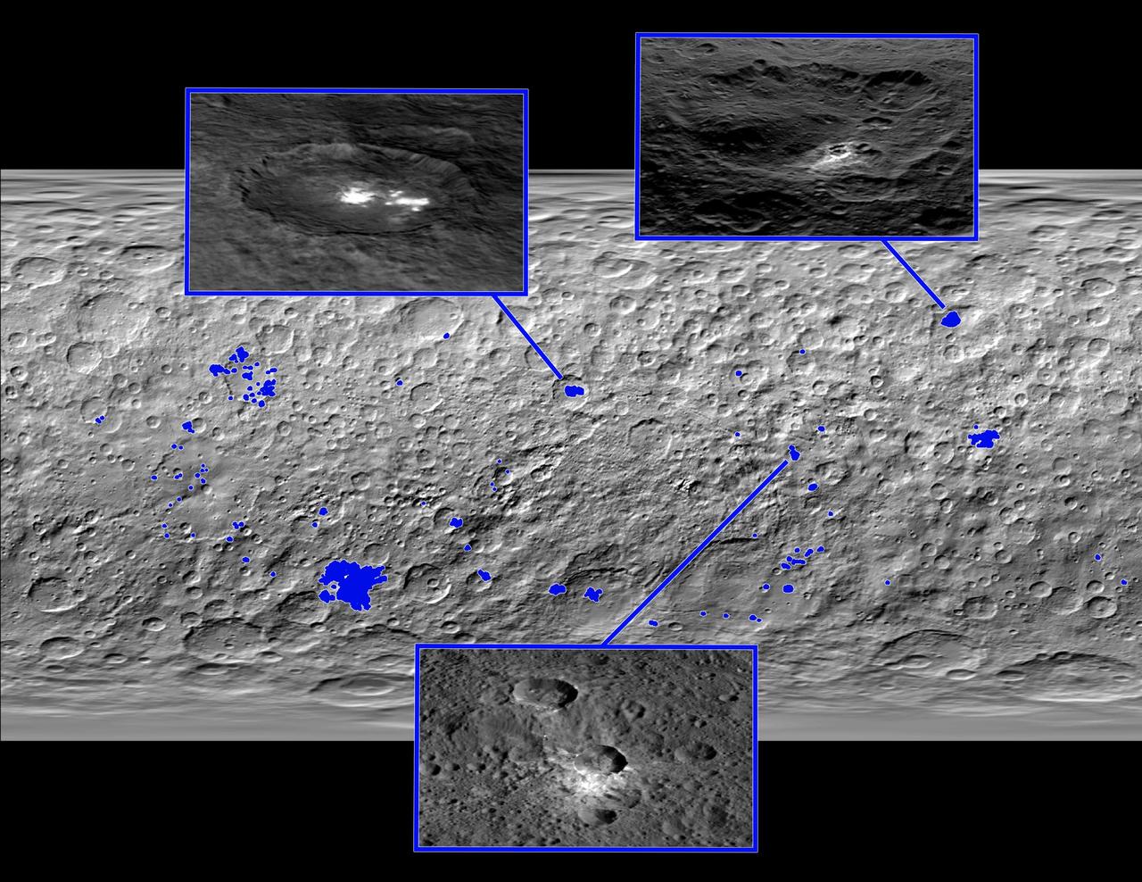
This map of Ceres, made from images taken by NASA's Dawn spacecraft, shows the locations of about 130 bright areas across the dwarf planet's surface, highlighted in blue. Most of these bright areas are associated with craters. Three insets zoom in on a few areas of interest. Occator Crater, containing the brightest area on Ceres, is shown at top left; Oxo Crater, the second-brightest feature on Ceres, is at top right. In a paper published in the Dec. 10, 2015, issue the journal Nature, Dawn mission scientists identify what they believe to be diffuse hazes at both Occator and Oxo. They believe the hazes appear when the sun shines on these craters, possibly from the sublimation of ice. A typical Ceres crater with bright material that does not appear to have remaining ice is shown at bottom. The bright material in this crater and others appears to originate from mineral salts that may have once been mixed with water ice, but dried up over time, scientists wrote in the same paper. http://photojournal.jpl.nasa.gov/catalog/PIA20183
This image from NASA's Dawn spacecraft showing the northern part of Hanami Planum on Ceres honors the Japanese cherry blossom festival, or "Hanami," which is a long-standing Japanese tradition of welcoming spring. Hanami Planum is the third largest geological feature on Ceres, after Vendimia Planitia and the Samhain Catenae. It extends over 345 miles (555 kilometers). This image shows familiar features, such as Occator Crater, characterized both by bright material inside the crater and dark ejecta material outside. Several parallel linear features, called Junina Catenae, can be seen departing from Occator and extending toward the top of the image. These catenae are chains of small craters formed by the impact and scouring of material ejected when large craters are formed. Scientists were able to relate these crater chains to Urvara and Yalode. Even though these are located in the southern hemisphere, some of their ejecta could reach the northern hemisphere, thanks to Ceres' fast rotation and small size. This image was obtained by Dawn on June 15, 2015. The spacecraft was then in its survey orbit (2,700 miles, or 4,400 kilometers high), when the footprint of Dawns framing camera on Ceres surface was about 260 miles (420 kilometers). The resolution is 1,400 feet (410 meters) per pixel. The central coordinates of the picture are 14 degrees north latitude, 213 degrees east in longitude. https://photojournal.jpl.nasa.gov/catalog/PIA21921
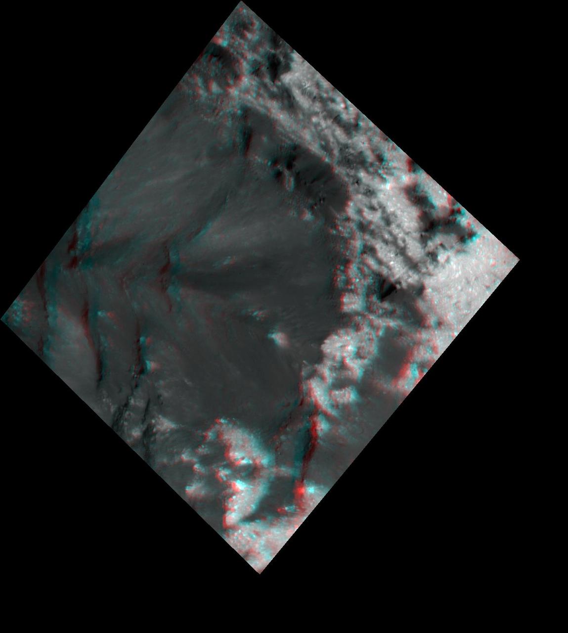
Scientists created this stereo view, called an anaglyph, with two images of the same part of Ceres's surface taken by Dawn on different orbits and from different viewing angles. The images were artificially colored and combined so that when viewed through glasses with a red filter on the left and blue on the right, they provide a 3-D view. The images used in this anaglyph were obtained by NASA's Dawn spacecraft from an altitude of about 21 miles (34 kilometers). The center of this picture is located at about 20.4 degrees north latitude and 239.9 degrees east longitude. https://photojournal.jpl.nasa.gov/catalog/PIA22863
This view obtained by NASA's Dawn spacecraft during its Survey orbit illustrates the diversity and complexity of Ceres' geology. It shows familiar features: Occator Crater with its bright deposits (called faculae) of carbonates and other salts, a series of linear features (at right) called Samhain Catenae, and another large crater on the right side of the image called Kirnis. A relatively fresh crater called Lociyo, superimposed on an older crater, can be seen toward the bottom left of the picture. Studying the morphologies and relationships between various types of geological features can help scientists reconstruct Ceres' history. Occator appears to be one of the youngest features in this picture, except for a couple of smaller craters. The 71-mile-wide (115-kilometer-wide) Kirnis Crater on the other hand is an old, eroded crater. It owes its peculiar polygonal shape in part to its overlap with one of the Samhain Catenae. This illustrates the role of fractures in driving the geometry of some of Ceres' craters. The origin of these particular catenae is not understood yet, and is not necessarily related to the Pongal Catena. Kirnis Crater is named after a Lithuanian spirit-guardian of cherry trees, whereas the Samhain Catenae refer to a Gaelic festival organized at the end of the harvest season. It was observed in Ireland and Scotland during seven days in October and November, nearly halfway between the autumn equinox and the winter solstice. This picture was obtained on June 25, 2015, from an altitude of 2,700 miles (4,400 kilometers). It is centered at 1.7 degrees north latitude, and 249 degrees east longitude. https://photojournal.jpl.nasa.gov/catalog/PIA21409
This image was obtained by NASA's Dawn spacecraft on July 23, 2018 from an altitude of about 84 miles (135 kilometers). The center of this picture is located at about 18.7 degrees north latitude and 243.6 degrees east longitude. https://photojournal.jpl.nasa.gov/catalog/PIA22758
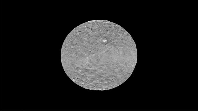
This topographical map of Ceres, made with images from NASA's Dawn spacecraft, shows all of the dwarf planet's named features as of September 2016. Dawn celebrated nine years since launch on September 27, 2016. To date, more than 110 places on Ceres have been named. These include craters such as Occator Crater, home of the brightest areas on the dwarf planet, as well as crater chains called catenae, mountains such as Ahuna Mons, and other geological features Among the most recently named features is Kwanzaa Tholus, named after the African-American winter holiday Kwanzaa, which is based on ancient African harvest festivals. A tholus is a small dome-shaped mountain or hill. There are a total of seven tholi named on Ceres. The latest list of features on Ceres can be found at the USGS Planetary Nomenclature website. http://photojournal.jpl.nasa.gov/catalog/PIA20918
This enhanced color image of Ceres' surface was made from data obtained on April 29, 2017, when NASA's Dawn spacecraft was exactly between the sun and Ceres. Dawn's framing cameras took images of Ceres with a clear filter as well as five different color filters. Images combining these different color filter perspectives reveal fine details of Ceres' surface. For example, they emphasize the distinct compositions and textures of the material ejected from craters. The brightest region on Ceres, called Cerealia Facula, is highlighted in Occator Crater in the center of this image. Vinalia Faculae, the set of secondary bright spots in the same crater, are located to the right of Cerealia Facula. One of the darkest regions on Ceres is next to Occator, and represents ejected material from the impact that formed the crater. The ejected material forms a large arc that extends over several hundred kilometers, below the center of Ceres in this image. That material's distribution is partly determined by Ceres' rotation. Other craters also show a mixture of bright and dark regions. While the bright areas are generally identified as salt-rich material excavated from Ceres' crust, the origin of the dark material remains to be explained. It may have been excavated from a different layer within Ceres' subsurface than the rest of the ejecta blanket. Scientists will continue analyzing the color data to look for clues about the nature of the different materials on Ceres. The blueish color is generally found in association with young craters. Scientists believe the color relates to processes that occur when an impact ejects and redistributes material on the surface. The continuous bombardment of Ceres' surface by micrometeorites alters the texture of the exposed material, leading to its reddening. This image was taken altitude of about 12,000 miles (20,000 kilometers). https://photojournal.jpl.nasa.gov/catalog/PIA21406
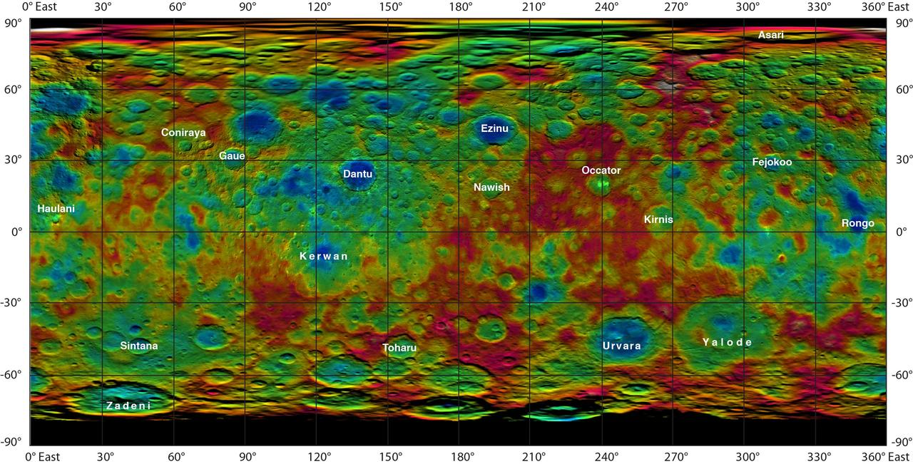
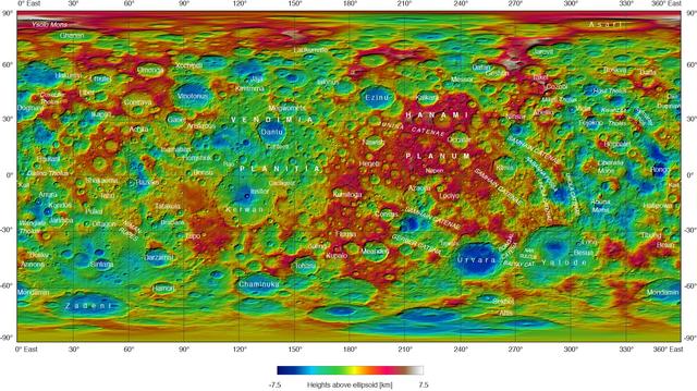
This color-coded map from NASA Dawn mission shows the highs and lows of topography on the surface of dwarf planet Ceres. It is labeled with names of features approved by the International Astronomical Union. Occator, the mysterious crater containing Ceres' mysterious bright spots, is named after the Roman agriculture deity of harrowing, a method of leveling soil. They retain their bright appearance in this map, although they are color-coded in the same green elevation of the crater floor in which they sit. The color scale extends about 5 miles (7.5 kilometers) below the surface in indigo to 5 miles (7.5 kilometers) above the surface in white. The topographic map was constructed from analyzing images from Dawn's framing camera taken from varying sun and viewing angles. The map was combined with an image mosaic of Ceres and projected as an simple cylindrical projection. http://photojournal.jpl.nasa.gov/catalog/PIA19606

This image from NASA's Dawn spacecraft highlights Axomama Crater, the small crater shown to the right of center. It is 3 miles (5 kilometers) in diameter and located just inside the western rim of Dantu Crater. Axomama is one of the newly named craters on Ceres. Its sharp edges indicate recent emplacement by a small impact. This picture also shows details on the floor of Dantu, which comprises most of the image. The many fractures and the central pit (see also PIA20303) are reminiscent of Occator Crater and could point to a similar formation history, involving activity driven by the presence of liquid water in the subsurface. Axomama is named after the Incan goddess of potato, or "Potato-mother." NASA's Dawn spacecraft acquired this picture during its extended mission on July 24, 2016, from its low altitude mapping orbit at about 240 miles (385 kilometers) above the surface. The center coordinates of this image are 24 degrees north latitude, 131 degrees east longitude. https://photojournal.jpl.nasa.gov/catalog/PIA21908
NASA's Dawn spacecraft successfully observed Ceres at opposition on April 29, 2017, taking images from a position exactly between the sun and Ceres' surface. Mission specialists had carefully maneuvered Dawn into a special orbit so that the spacecraft could view Occator Crater, which contains the brightest area of Ceres, from this new perspective. A movie shows these opposition images, with contrast enhanced to highlight brightness differences. The bright spots of Occator stand out particularly well on an otherwise relatively bland surface. Dawn took these images from an altitude of about 12,000 miles (20,000 kilometers). Based on data from ground-based telescopes and spacecraft that have previously viewed planetary bodies at opposition, scientists predicted that Ceres would appear brighter from this opposition configuration. This increase in brightness, or "surge," relates the size of the grains of material on the surface, as well as how porous those materials are. The science motivation for performing these observations is further explained in the March 2017 issue of the Dawn Journal blog. A movie can be viewed at https://photojournal.jpl.nasa.gov/catalog/PIA21405

This collage shows some of the most interesting geological sites that NASA's Dawn spacecraft has revealed at dwarf planet Ceres. Images were acquired with the spacecraft's framing camera during various phases of the mission: Survey orbit at a distance of about 2,700 miles (4,400 kilometers); high-altitude mapping orbit (HAMO) at a distance of 915 miles (1,470 kilometers) from Ceres; and low-altitude mapping orbit (LAMO) at an altitude of 240 miles (385 kilometers). In the first row, from left to right: Ceres in shown in false color, roughly centered on Occator Crater, home of the brightest area on Ceres. This picture combines color images obtained by Dawn in its survey orbit. Red corresponds to a wavelength range around 980 nanometers (near infrared), green to a wavelength range around 750 nanometers (red, visible light) and blue to a wavelength range of around 430 nanometers (blue, visible light). This picture illustrates the diversity of terrains on Ceres where the bluish material points to recently emplaced material and the brownish background material is associated with older terrains. Juling Crater (12 miles, 20 kilometers in diameter) as seen in LAMO. Central coordinates are 36 degrees south latitude, 168 degrees east longitude. It is named after the Sakai/Orang Asli (Malaysia) spirit of the crops. This crater displays evidence for the presence of ice -- for example, in the form of a large flow feature seen at the top of the image. Oxo Crater (6 miles, 10 kilometers in diameter) as seen in LAMO. Center coordinates are 42 degrees north latitude, 0 degrees east longitude. It is named after the god of agriculture in Afro-Brazilian beliefs of Yoruba derivation. Oxo hosts the first site at which Dawn detected ice on Ceres, exposed by a landslide. Ahuna Mons is not only a volcano, but also the tallest mountain on Ceres. It is about 2.5 miles (4 kilometers) high and 11 miles (17 kilometers) wide. Center coordinates are 10 degrees south latitude, 316 degrees east longitude. This view combines images obtained in LAMO in blue (430 nanometers), green (750 nanometers) and infrared (980 nanometers) color filters. Ahuna is named after the Sumi tribe (Nagaland, northeastern India) traditional post-harvest thanksgiving festival. Second Row Occator Crater (57 miles, 92 kilometers across) is seen in LAMO images. Center coordinates are 20 degrees north latitude, 239 degrees east longitude. Named after the Roman agricultural deity of the harrowing. This image shows a "Type I" flow feature with a thick "toe" typical of rock glaciers and icy landslides on Earth as viewed in LAMO. The flow feature, found in Ghanan Crater (77 degrees north latitude, 31 degrees east longitude), is one of the most voluminous on Ceres. Enhanced color view of Haulani Crater (21 miles, 34 kilometers in diameter) in color observed in HAMO. Central coordinates: 6 degrees north latitude, 11 degrees east longitude. Named after the Hawaiian plant goddess. Kokopelli Crater (21 miles, 34 kilometers in diameter) seen in LAMO. Central coordinates: 18 degrees north latitude, 125 degrees east longitude. Named after the Pueblo (SW USA) fertility deity, who presides over agriculture. This crater displays a nice arrangement of scarps that likely formed when the crater partly collapsed during its formation. Third Row Central region of Occator Crater, called Cerealia Facula, seen in color. The facula -- or "bright spot" -- is about 9 miles (14 kilometers) in diameter. Center coordinates: 20 N, 240 E. Cerealia refers to the major festival in Ancient Rome that celebrates the grain goddess Ceres (8 days in mid- to late April). The view was produced by combining the highest resolution images of Occator obtained in LAMO (at image scales of 35 meters, or 115 feet, per pixel) with color images obtained in HAMO (at image scales of 135 meters, or about 440 feet, per pixel). The three images used to produce the color were taken using filters centered at 430, 750 and 980 nanometers (the last being slightly beyond the range of human vision, in the near-infrared). North part of Nar Sulcus seen in LAMO. The full feature is about 39 miles (63 km) in length and is located around 42 degrees south latitude, 280 degrees east longitude. Nar is a Azerbaijani festival of pomegranate harvest held in October-November in Goychay city, center of pomegranate cultivation in Azerbaijan. A sulcus is a set of parallel furrows or ridges. Ikapati Crater (31 miles, 50 kilometers in diameter) seen in LAMO. Central coordinates: 34 degrees north latitude, 46 degrees east longitude. Ikapati is named after the Philippine goddess of the cultivated lands. The crater has a smooth floor, probably because heat from the impact that formed Ikapati caused ice in the ground to melt, and then refreeze. This view of Ceres, taken in LAMO, shows an area located at approximately 86 degrees south longitude, 177 degrees east longitude. This part of Ceres, near the south pole, has such long shadows because, from the perspective of this location, the sun is near the horizon. At the time this image was taken, the sun was 4 degrees north of the equator. If you were standing this close to Ceres' south pole, the sun would never get high in the sky during the course of a nine-hour Cerean day. https://photojournal.jpl.nasa.gov/catalog/PIA22090
Scientists created this stereo view, called an anaglyph, with two images of the same part of Ceres's surface taken by Dawn on different orbits and from different viewing angles. The images were artificially colored and combined so that when viewed through glasses with a red filter on the left and blue on the right, they provide a 3-D view. The images used in this anaglyph were obtained by NASA's Dawn spacecraft from an altitude of about 21 miles (34 kilometers). This feature is located at about 19.5 degrees north latitude and 239.2 degrees east longitude, in the western part of Cerealia Facula. https://photojournal.jpl.nasa.gov/catalog/PIA22862