
A Trail of Salts

Electroyte with Ulta-High Salt Concentration
Salt Water Taffy
History Leaves Salts Behind
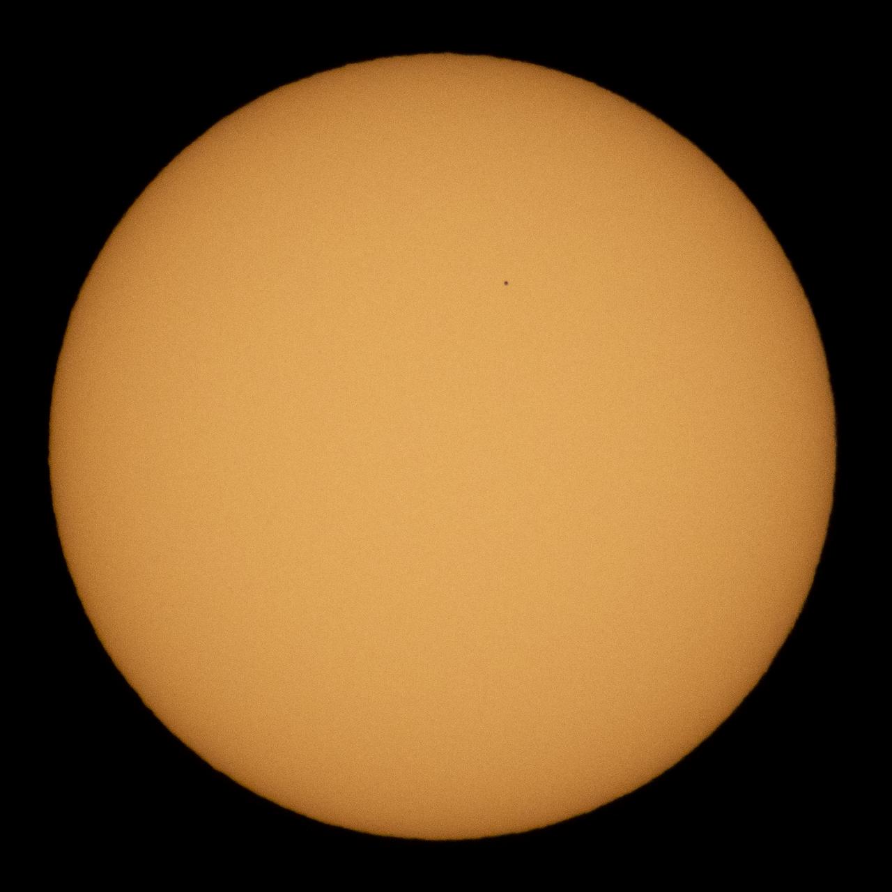
The planet Mercury is seen in silhouette as it transits across the face of the sun, Monday, Nov. 11, 2019 in Salt Lake City, Utah. Mercury’s last transit was in 2016. the next won't happen again until 2032. Photo Credit: (NASA/Joel Kowsky)
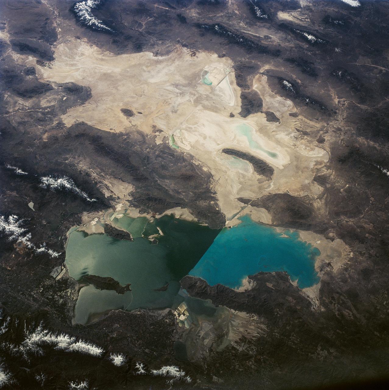
This is a view of the Great Salt Lake and nearby Bonneville Salt Flats, UT, (41.0N, 112.5W). A railroad causeway divides the lake with a stark straight line changing the water level and chemistry of the lake as a result. Fresh water runoff enters from the south adding to the depth and reducing the salinity. The north half receives little frsh water and is more saline and shallow. The Bonnieville Salt Flats is the lakebed of a onetime larger lake.
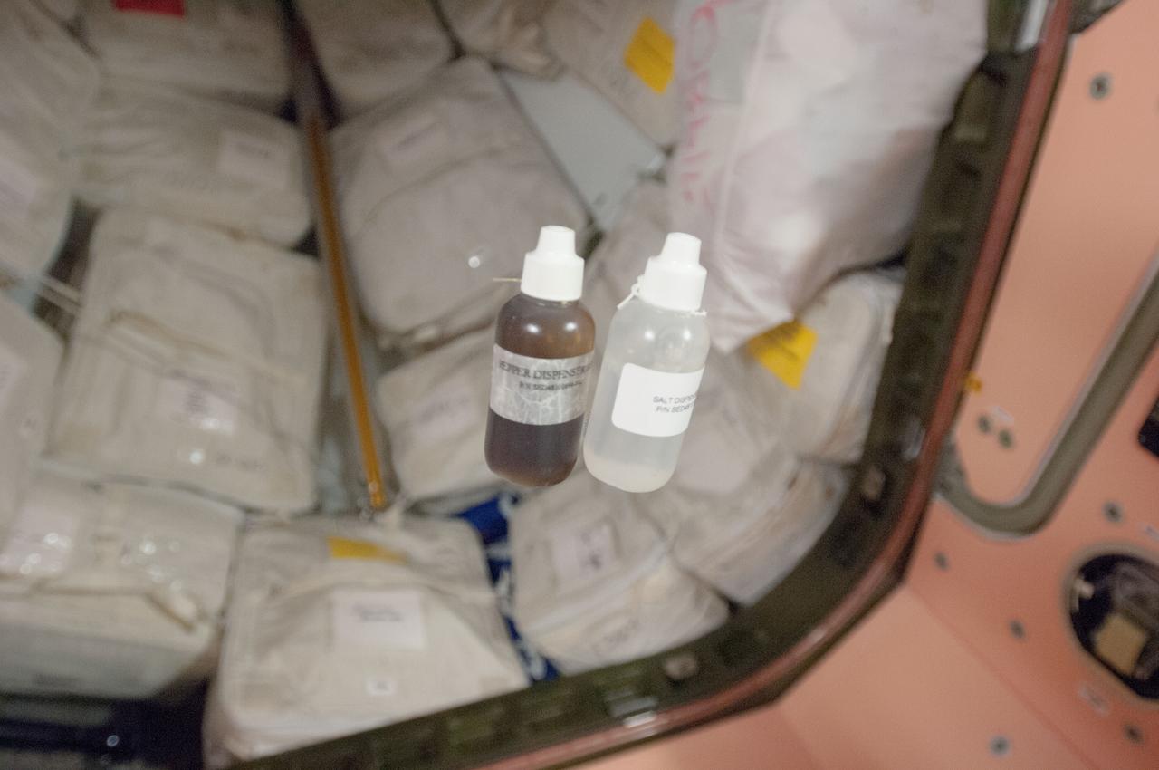
View of liquid pepper and salt dispensers floating in the aft hatch area of the Unity Node 1 during Expedition 35.
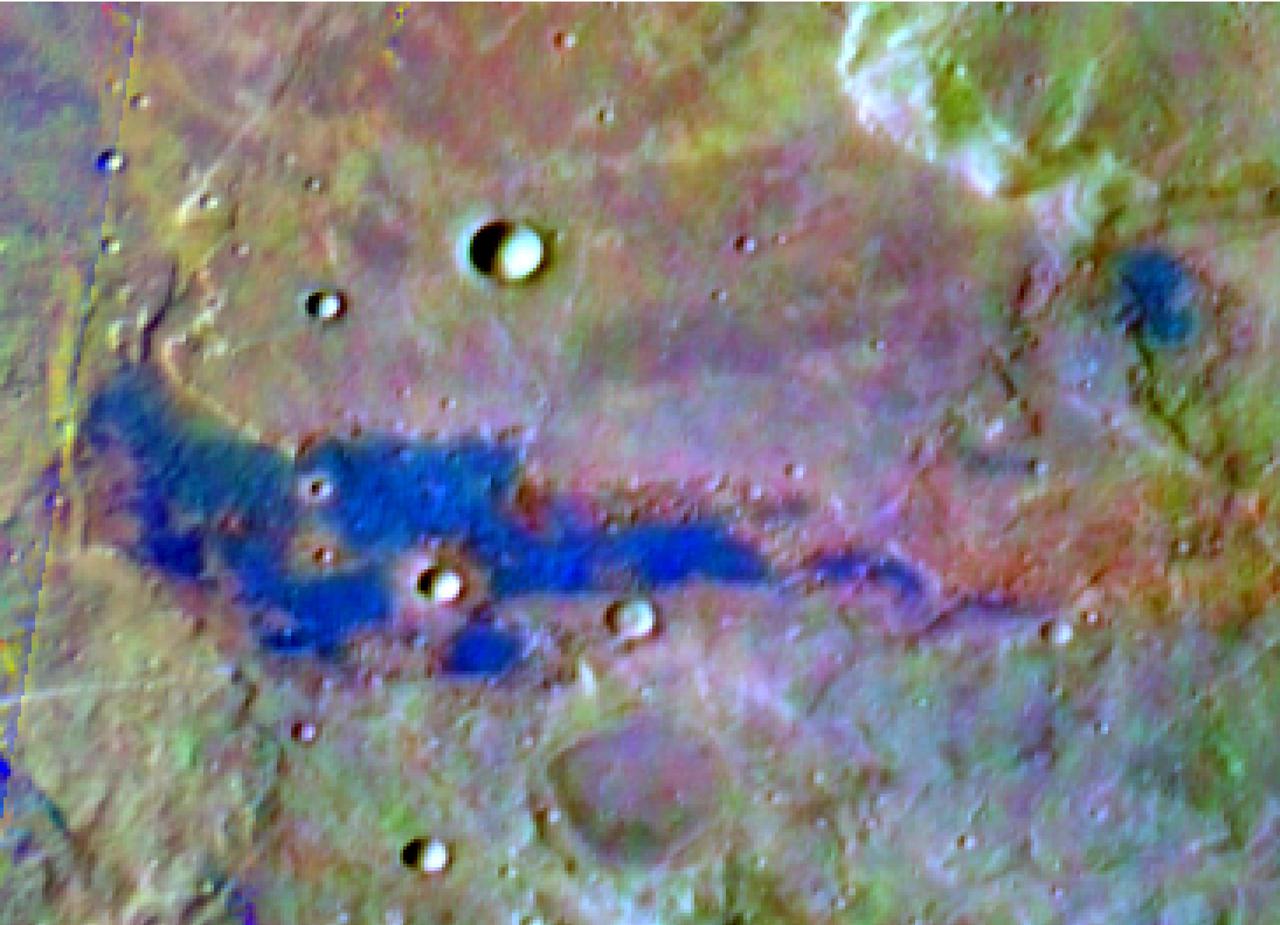
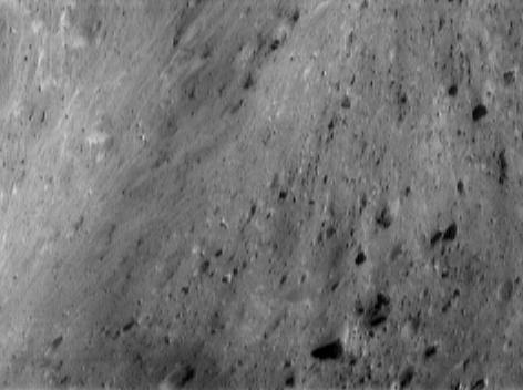
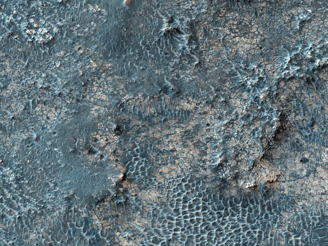
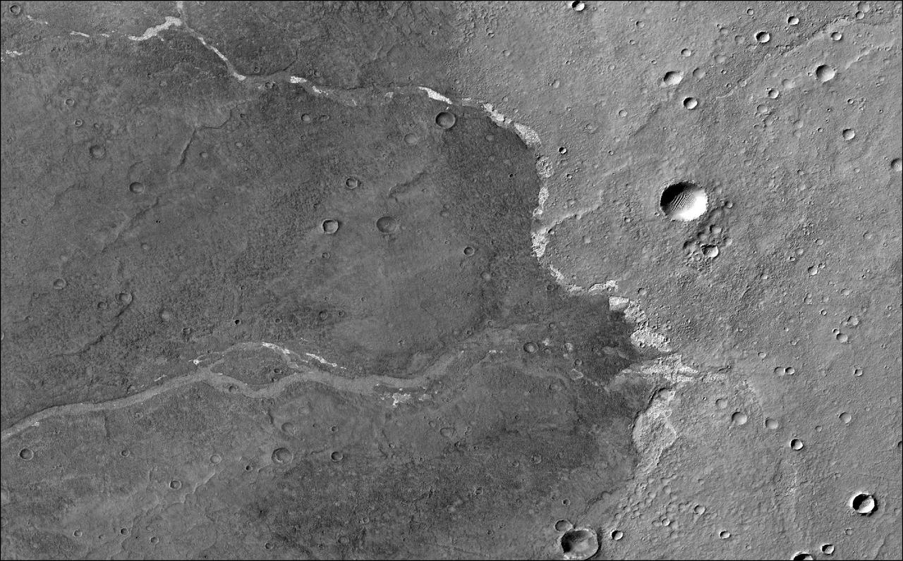
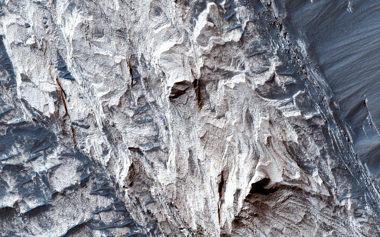
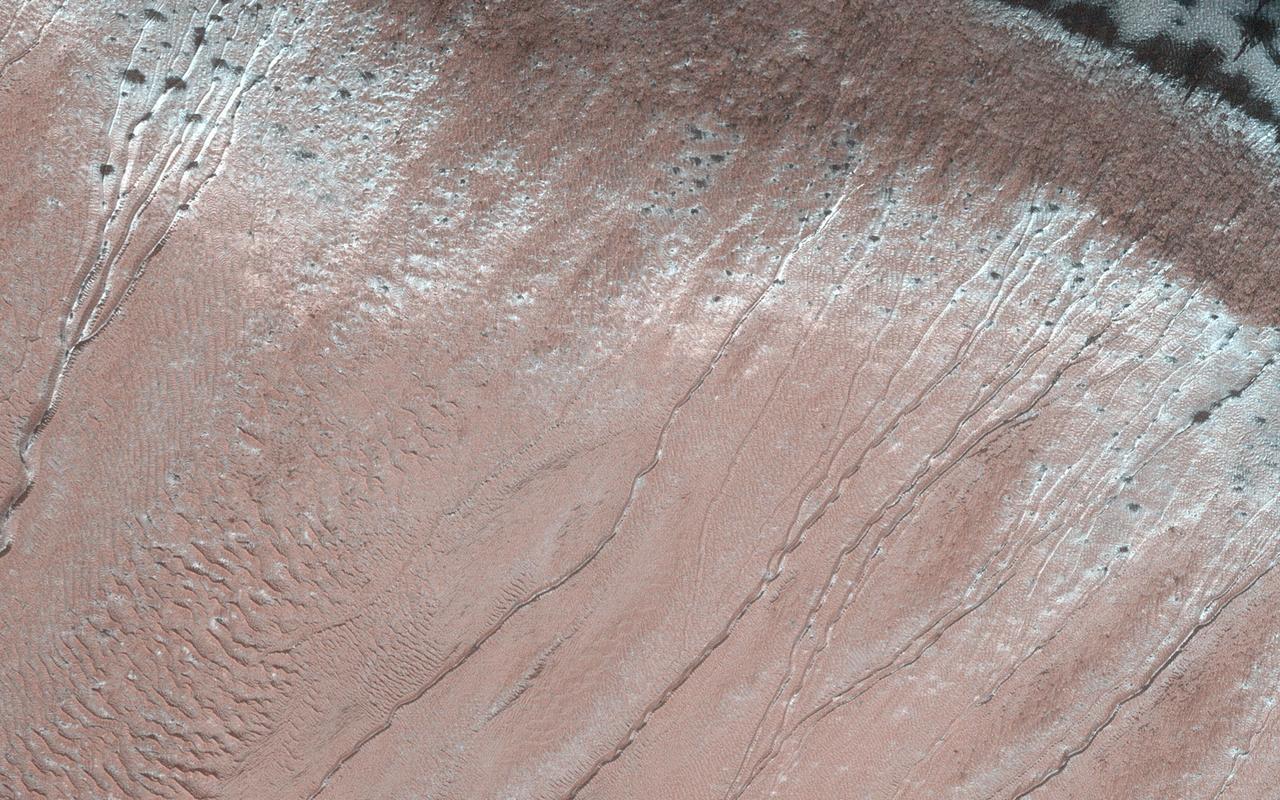
Chloride Salt Deposit in Southern Highlands of Mars
Bright Exposures of Chloride Salt on Southern Mars
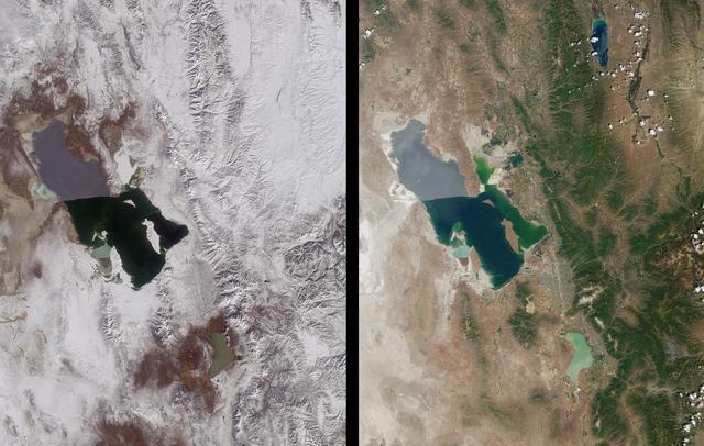
As seen from space, the Great Salt Lake, Utah, USA (41.5N, 112.5W) appears as two separate bodies of water with a narrow divider in the middle. At the turn of the century, a railroad bridge without culverts, was built across the lake and ever since, the water and salinity levels have been uneqal on either side. Fed by snowmelt from the nearby Wasatch Mountains, the lake in recent years has had record high water levels, threatening to flood the local areas.
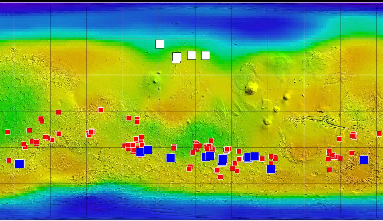
This map of Mars from NASA Mars Odyssey orbiter shows relative locations of three types of findings related to salt or frozen water, plus a new type of finding that may be related to both salt and water.
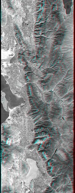
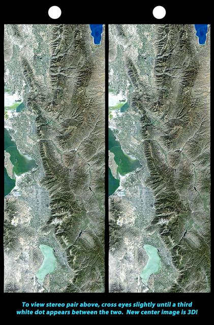
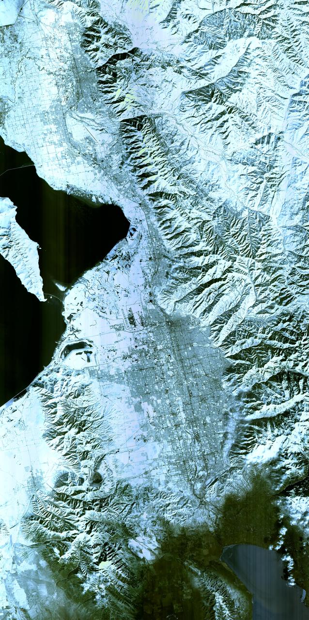
This anaglyph, from NASA Shuttle Radar Topography Mission, is of Salt Lake City, Utah. 3D glasses are necessary to view this image.

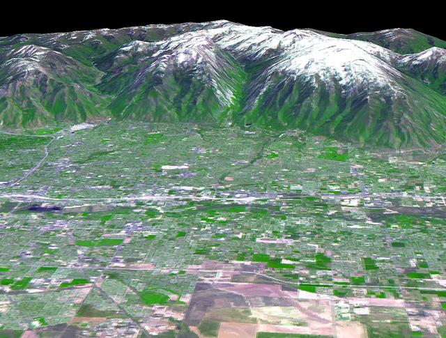
Salt Lake City, Utah, Winter 2001 The 2002 Winter Olympics are hosted by Salt Lake City at several venues within the city, in nearby cities, and within the adjacent Wasatch Mountains. This simulated natural color image presents a snowy, winter view of north central Utah that includes all of the Olympic sites. The image extends from Ogden in the north, to Provo in the south; and includes the snow-capped Wasatch Mountains and the eastern part of the Great Salt Lake. This image was acquired on February 8, 2001 by the Advanced Spaceborne Thermal Emission and Reflection Radiometer (ASTER) on NASA's Terra satellite. With its 14 spectral bands from the visible to the thermal infrared wavelength region, and its high spatial resolution of 15 to 90 meters (about 50 to 300 feet), ASTER will image Earth for the next 6 years to map and monitor the changing surface of our planet. ASTER is one of five Earth-observing instruments launched December 18,1999, on NASA's Terra satellite. The instrument was built by Japan's Ministry of Economy, Trade and Industry. A joint U.S./Japan science team is responsible for validation and calibration of the instrument and the data products. Dr. Anne Kahle at NASA's Jet Propulsion Laboratory, Pasadena, California, is the U.S. Science team leader; Bjorn Eng of JPL is the project manager. ASTER is the only high resolution imaging sensor on Terra. The Terra mission is part of NASA's Earth Science Enterprise, along-term research and technology program designed to examine Earth's land, oceans, atmosphere, ice and life as a total integrated system. The broad spectral coverage and high spectral resolution of ASTER will provide scientists in numerous disciplines with critical information for surface mapping, and monitoring dynamic conditions and temporal change. Example applications are: monitoring glacial advances and retreats; monitoring potentially active volcanoes; identifying crop stress; determining cloud morphology and physical properties; wetlands evaluation; thermal pollution monitoring; coral reef degradation; surface temperature mapping of soils and geology; and measuring surface heat balance. Image credit: NASA/GSFC/METI/ERSDAC/JAROS, and U.S./Japan ASTER Science Team Credit: <b><a href="http://www.earthobservatory.nasa.gov/" rel="nofollow"> NASA Earth Observatory</a></b> <b><a href="http://www.nasa.gov/audience/formedia/features/MP_Photo_Guidelines.html" rel="nofollow">NASA image use policy.</a></b> <b><a href="http://www.nasa.gov/centers/goddard/home/index.html" rel="nofollow">NASA Goddard Space Flight Center</a></b> enables NASA’s mission through four scientific endeavors: Earth Science, Heliophysics, Solar System Exploration, and Astrophysics. Goddard plays a leading role in NASA’s accomplishments by contributing compelling scientific knowledge to advance the Agency’s mission. <b>Follow us on <a href="http://twitter.com/NASAGoddardPix" rel="nofollow">Twitter</a></b> <b>Like us on <a href="http://www.facebook.com/pages/Greenbelt-MD/NASA-Goddard/395013845897?ref=tsd" rel="nofollow">Facebook</a></b> <b>Find us on <a href="http://instagram.com/nasagoddard?vm=grid" rel="nofollow">Instagram</a></b>

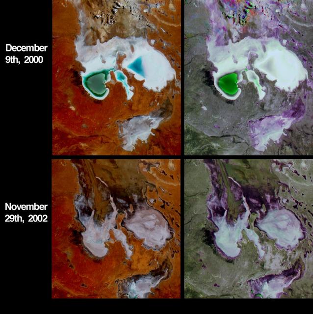
In the high plateau of southwestern Bolivia, two large salt deserts, or playas, are located between the eastern and western Andes. NASA Terra spacecraft depicted the playas on January 16, 2002 and January 3, 2003.
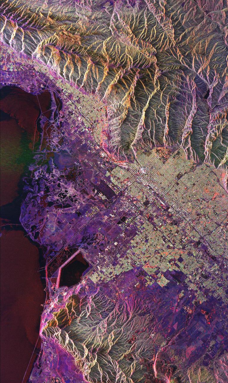
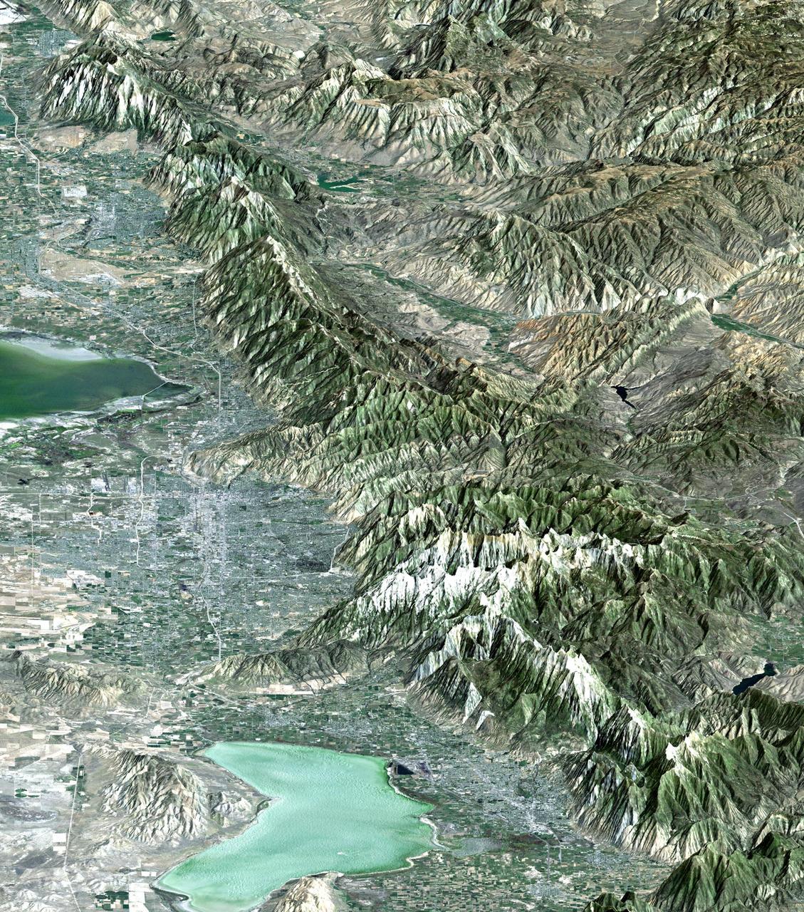
This radar image of Salt Lake City, Utah, illustrates the different land use patterns that are present in the Utah Valley. Salt Lake City lies between the shores of the Great Salt Lake (the dark area on the left side of the image) and the Wasatch Front Range (the mountains in the upper half of the image). The Salt Lake City area is of great interest to urban planners because of the combination of lake, valley and alpine environments that coexist in the region. Much of the southern shore of the Great Salt Lake is a waterfowl management area. The green grid pattern in the right center of the image is Salt Lake City and its surrounding communities. The Salt Lake City airport is visible as the brown rectangle near the center of the image. Interstate Highway 15 runs from the middle right edge to the upper left of the image. The bright white patch east of Interstate 15 is the downtown area, including Temple Square and the state capitol. The University of Utah campus is the yellowish area that lies at the base of the mountains, east of Temple Square. The large reservoir in the lower left center is a mine tailings pond. The semi-circular feature in the mountains at the bottom edge of the image is the Kennecott Copper Mine. The area shown is 60 kilometers by 40 kilometers (37 miles by 25 miles) and is centered at 40.6 degrees north latitude, 112.0 degrees west longitude. North is toward the upper left. This image was acquired by the Spaceborne Imaging Radar-C/X-Band Synthetic Aperture Radar (SIR-C/X-SAR) aboard the space shuttle Endeavour on April 10, 1994. The colors in this image represent the following radar channels and polarizations: red is L-band, horizontally transmitted and received; green is L-band, horizontally transmitted and vertically received; and blue is C-band, horizontally transmitted and vertically received. SIR-C/X-SAR, a joint mission of the German, Italian and United States space agencies, is part of NASA's Mission to Planet Earth program. http://photojournal.jpl.nasa.gov/catalog/PIA01798
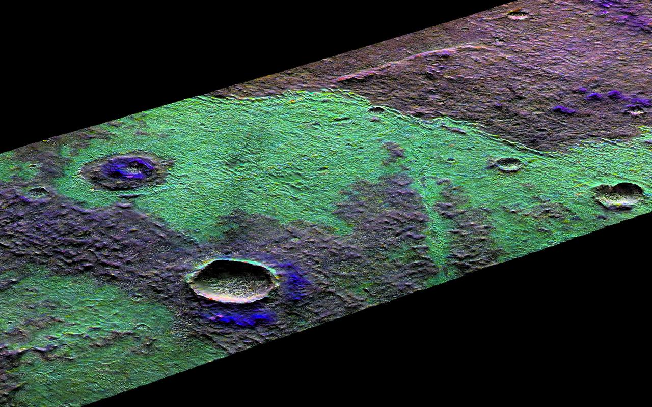
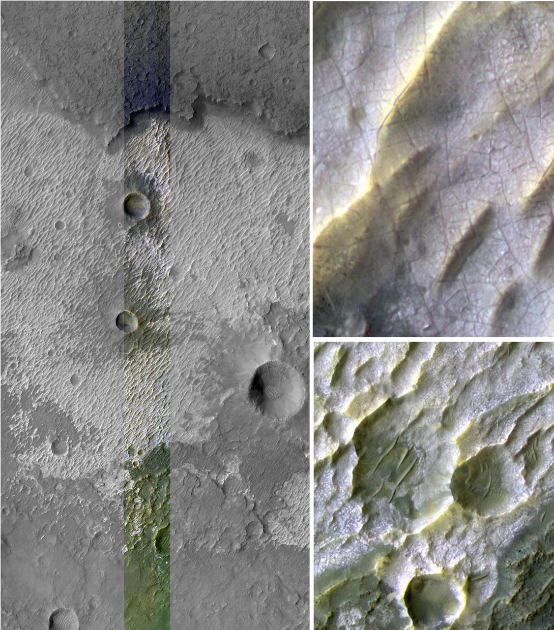
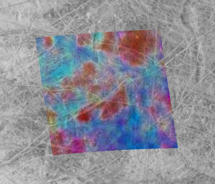
This 3D perspective view is a composite of both HiRISE and data from CRISM, another instrument onboard MRO. This view covers a small patch of ancient Martian real estate in Terra Sirenum. CRISM collects spectral data that can be used as a chemical fingerprint for the upper most surface. This information suggests that this small patch of surface is covered with salts (chlorides) represented in green and water-rich clays that appear in blue. CRISM colors can be added to high-resolution images to enhance our knowledge of these materials. They also match nicely with the surface features in our HiRISE image. For example, a fissure near the center of the image may be a a clue to the origin of the salts. The fissure may be a fracture where warm salt-laden water may have welled up, erupted and ponded on the surface. These waters then evaporated leaving the salt-rich deposits behind. https://photojournal.jpl.nasa.gov/catalog/PIA22867
The 2002 Winter Olympics are hosted by Salt Lake City at several venues within the city, in nearby cities, and within the adjacent Wasatch Mountains.
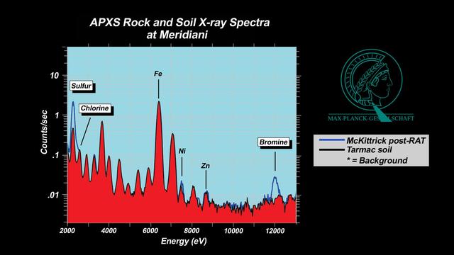
NASA's Perseverance Mars rover used its PIXL (Planetary Instrument for X-ray Lithochemistry) instrument to analyze the "Bellegarde" abrasion target – created when the rover scraped away surface area of the rock named "Rochette" – revealing salt minerals (the yellow color in the image). Salt crystals could have trapped bubbles of ancient water that, after the samples are returned to Earth, scientists could use to learn more about the environment these salts formed in. NASA's Jet Propulsion Laboratory built and manages operations of Perseverance and Ingenuity for the agency. Caltech in Pasadena, California, manages JPL for NASA. WATSON was built by Malin Space Science Systems (MSSS) in San Diego and is operated jointly by MSSS and JPL. A key objective for Perseverance's mission on Mars is astrobiology, including the search for signs of ancient microbial life. The rover will characterize the planet's geology and past climate, pave the way for human exploration of the Red Planet, and be the first mission to collect and cache Martian rock and regolith (broken rock and dust). Subsequent NASA missions, in cooperation with ESA (European Space Agency), would send spacecraft to Mars to collect these sealed samples from the surface and return them to Earth for in-depth analysis. The Mars 2020 Perseverance mission is part of NASA's Moon to Mars exploration approach, which includes Artemis missions to the Moon that will help prepare for human exploration of the Red Planet. https://photojournal.jpl.nasa.gov/catalog/PIA24835
The 2002 Winter Olympics are hosted by Salt Lake City at several venues within the city, in nearby cities, and within the adjacent Wasatch Mountains. This simulated natural color image presents a late spring view of north central Utah that includes all of the Olympic sites. The image extends from Ogden in the north, to Provo in the south; and includes the snow-capped Wasatch Mountains and the eastern part of the Great Salt Lake. This image was acquired on May 28, 2000 by the Advanced Spaceborne Thermal Emission and Reflection Radiometer (ASTER) on NASA's Terra satellite. With its 14 spectral bands from the visible to the thermal infrared wavelength region, and its high spatial resolution of 15 to 90 meters (about 50 to 300 feet), ASTER will image Earth for the next 6 years to map and monitor the changing surface of our planet. http://photojournal.jpl.nasa.gov/catalog/PIA03464
This image taken by NASA Mars Reconnaissance Orbiter covers part of a candidate landing site that appears to be a shallow depression with a deposit perhaps consisting of chlorides, like table salt.
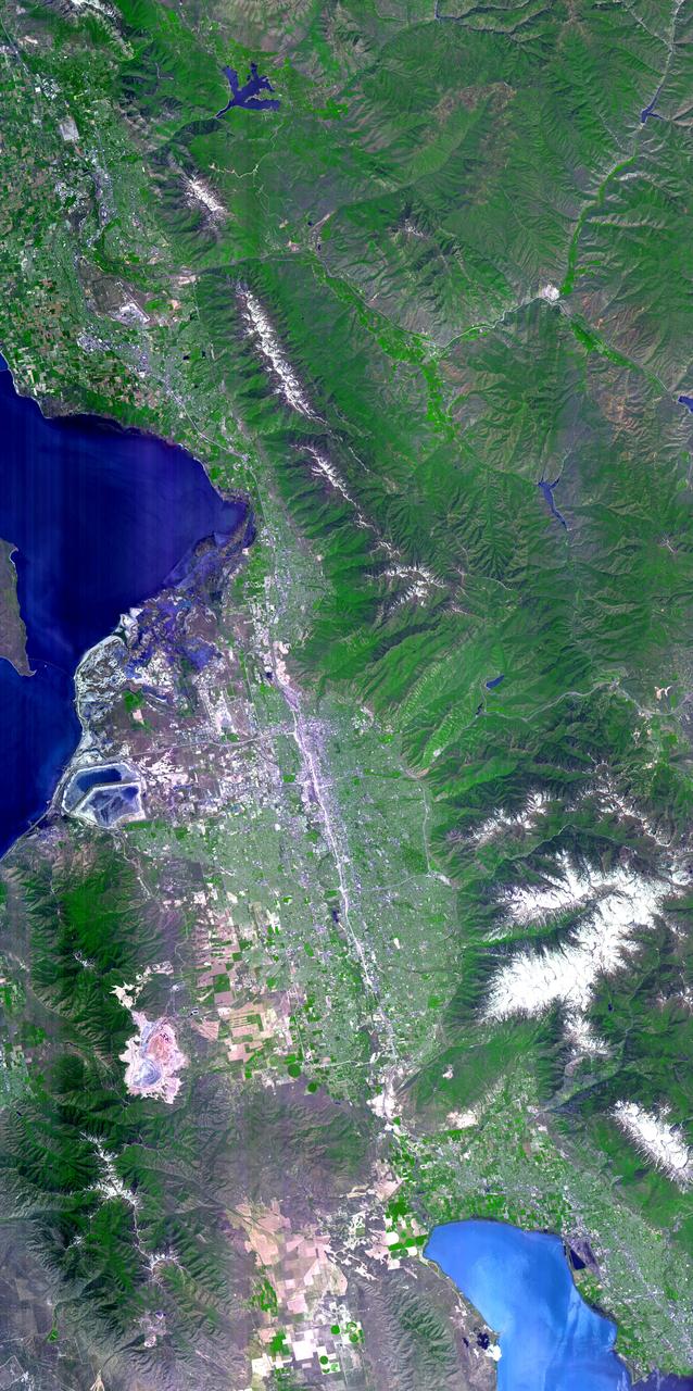
Magnificent views of the region surrounding Salt Lake City, Utah are captured in these winter and summer images from NASA Terra satellite imaged on February 8, 2001 and June 16, 2001.
The 2002 Winter Olympics are hosted by Salt Lake City at several venues within the city, in nearby cities, and within the adjacent Wasatch Mountains.
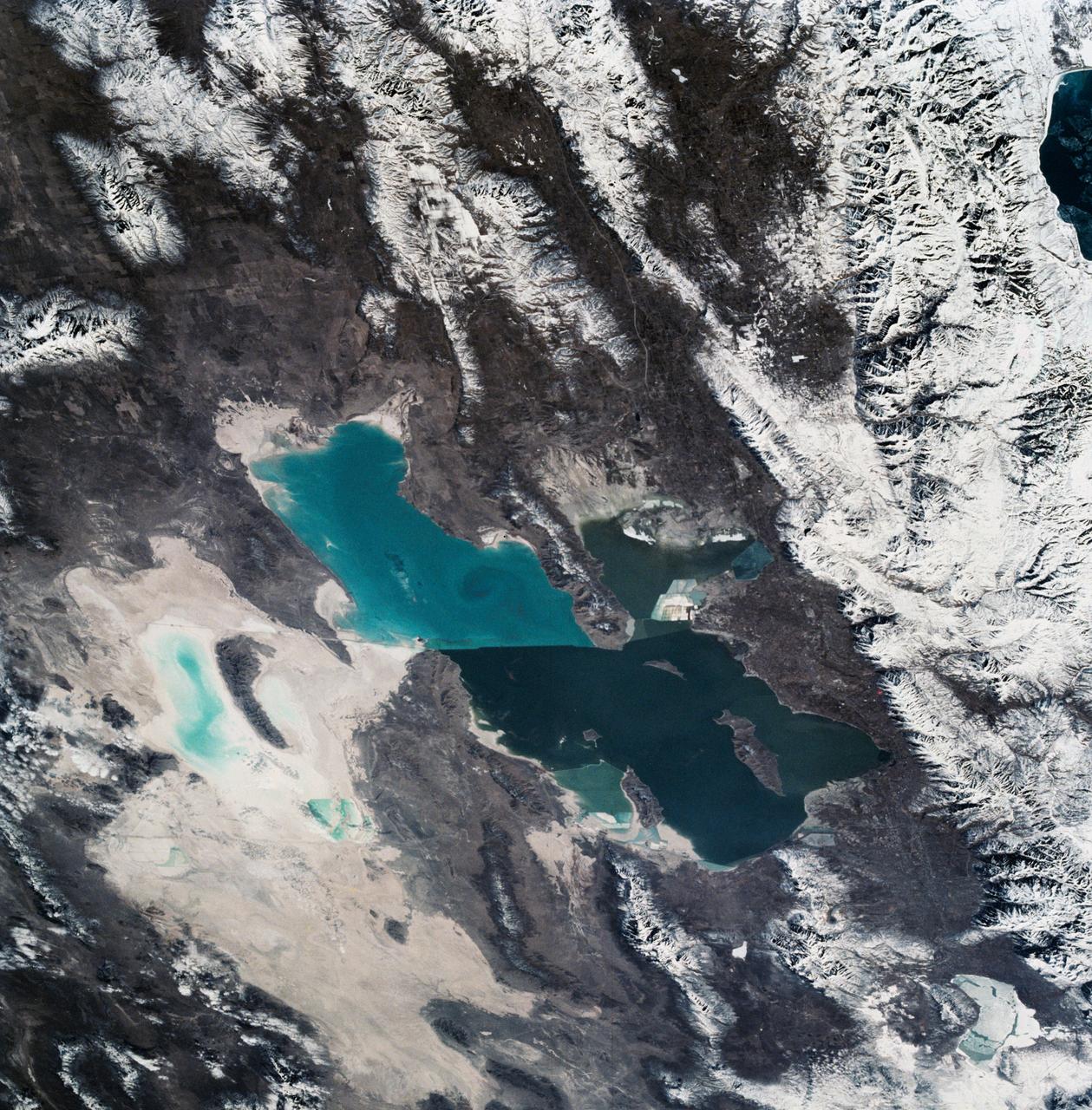
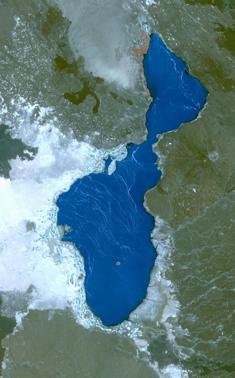
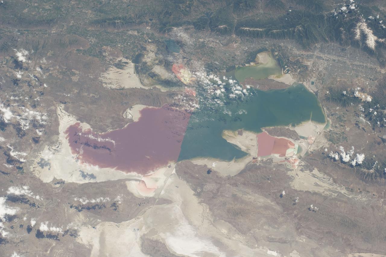
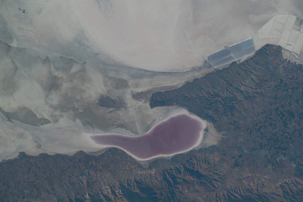
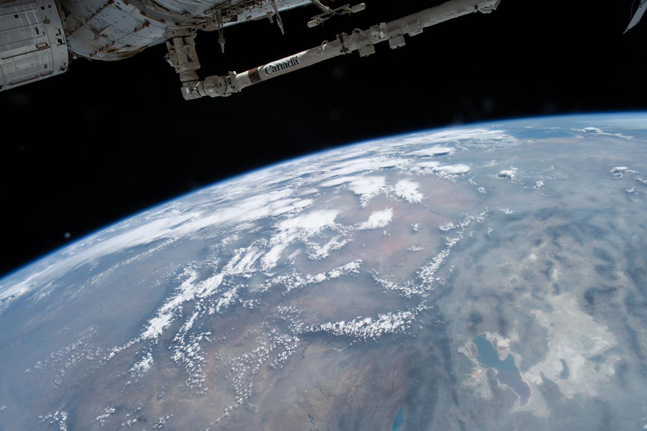
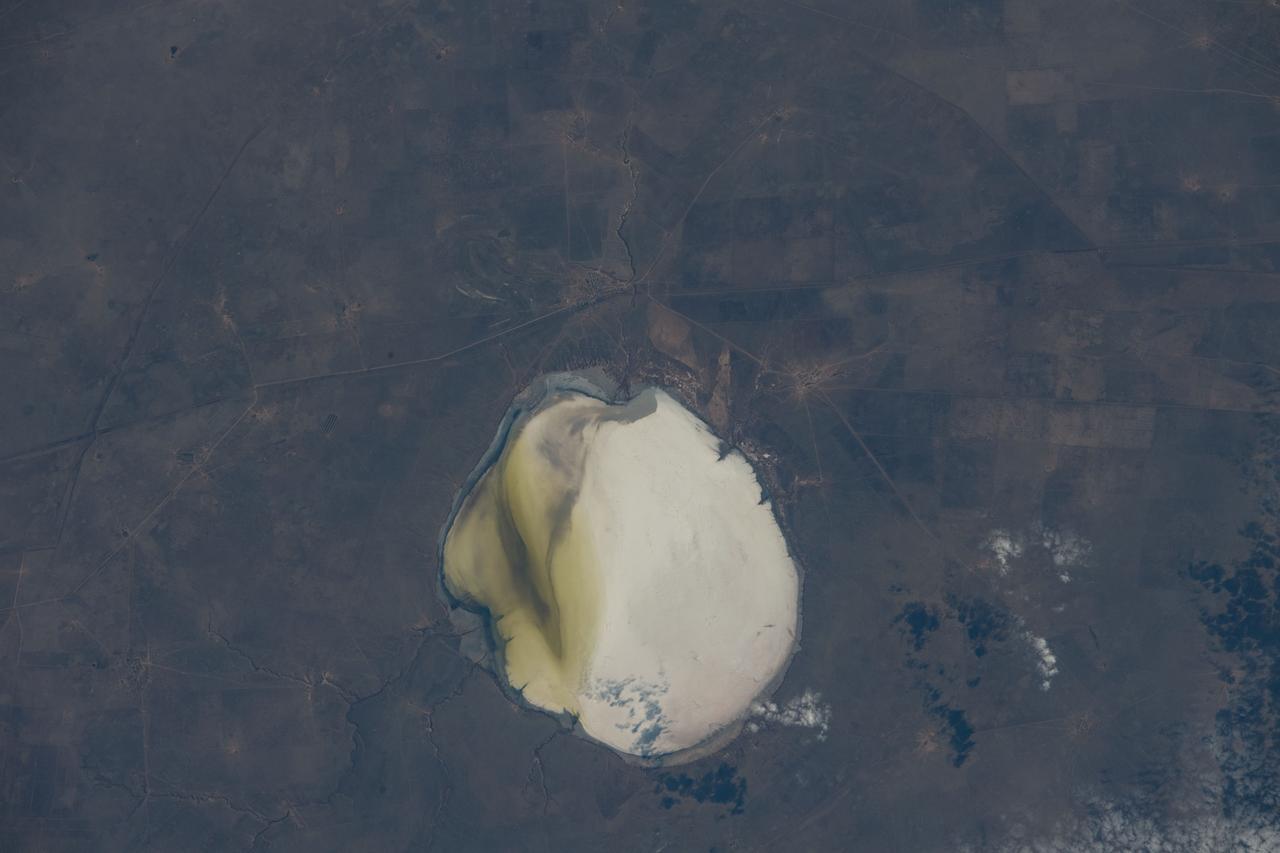
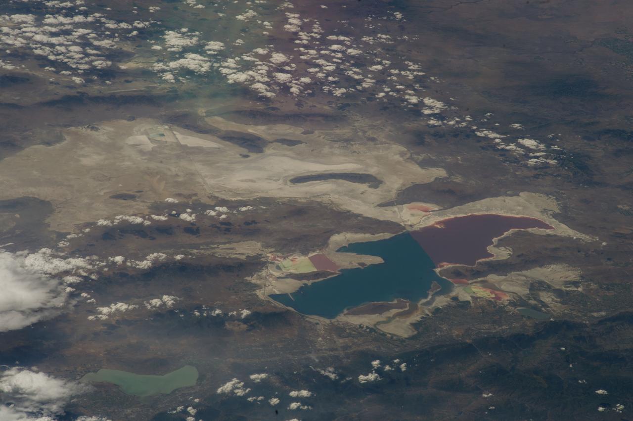
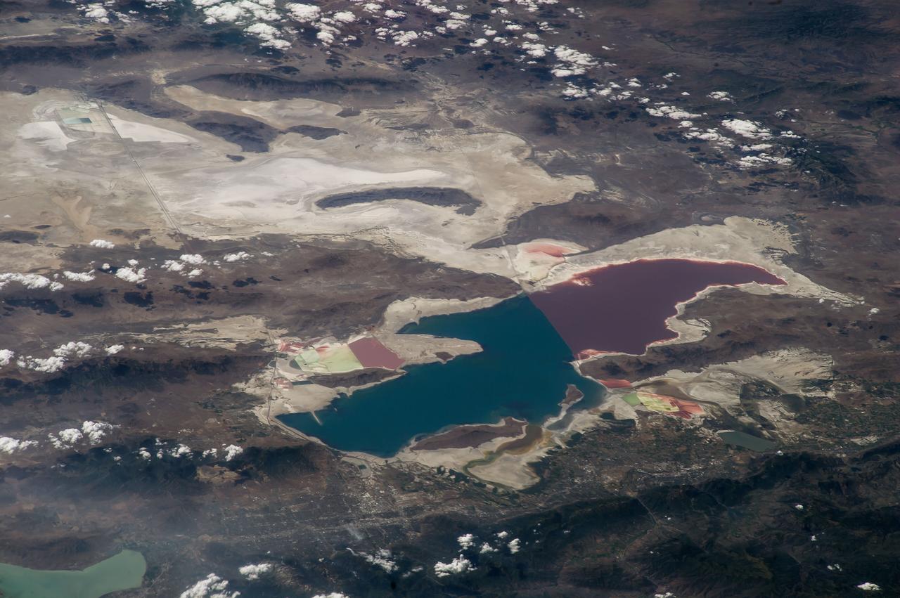
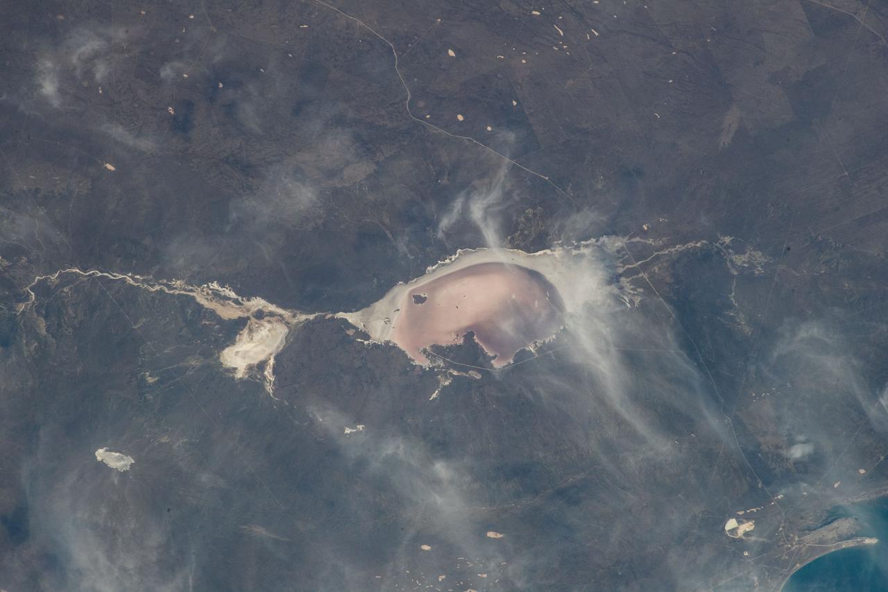
iss073e0865636 (Oct. 7, 2025) --- Bear Lake (left) is a freshwater lake spanning Idaho and Utah, and is smaller and much deeper than Utah's Great Salt Lake—averaging 208 feet compared to just 14 feet. The distinct color differences in the Great Salt Lake are caused by a railroad causeway: the red portion has much higher salinity than the blue, less saline section.
SL3-22-0322 (July-September 1973) --- An oblique view of the Salt Lake City, Utah area as photographed from Earth orbit by one of the six lenses of the Itek-furnished S190-A Multispectral Photographic Facility Experiment aboard the Skylab space station. Approximately two-thirds of the Great Salt Lake is in view. The smaller body of water south of Salt Lake City is Utah Lake. The Wasatch Range is on the east side of the Great Salt Lake. Federal agencies participating with NASA on the EREP project are the Departments of Agriculture, Commerce, Interior, the Environmental Protection Agency and the Corps of Engineers. All EREP photography is available to the public through the Department of Interior?s Earth Resources Observations Systems Data Center, Sioux Falls, South Dakota, 57198. Photo credit: NASA
NASA's Mars Reconnaissance Orbiter used its Context Camera to capture this image of Bosporos Planum, a location on Mars. The white specks are salt deposits found within a dry channel. The largest impact crater in the scene is nearly 1 mile (1.5 kilometers) across. https://photojournal.jpl.nasa.gov/catalog/PIA25047
The 2002 Winter Olympics are hosted by Salt Lake City at several venues within the city, in nearby cities, and within the adjacent Wasatch Mountains. This 3-D perspective view, in simulated natural colors, presents a late spring view over Salt Lake City towards the snow-capped Wasatch Mountains to the east. The image was created by draping ASTER image data over digital topography data from the US Geological Survey's National Elevation Data. This image was acquired on May 28, 2000 by the Advanced Spaceborne Thermal Emission and Reflection Radiometer (ASTER) on NASA's Terra satellite. With its 14 spectral bands from the visible to the thermal infrared wavelength region, and its high spatial resolution of 15 to 90 meters (about 50 to 300 feet), ASTER will image Earth for the next 6 years to map and monitor the changing surface of our planet. http://photojournal.jpl.nasa.gov/catalog/PIA03466
The 2002 Winter Olympics are hosted by Salt Lake City at several venues within the city, in nearby cities, and within the adjacent Wasatch Mountains. This simulated natural color image presents a snowy, winter view of north central Utah that includes all of the Olympic sites. The image extends from Ogden in the north, to Provo in the south; and includes the snow-capped Wasatch Mountains and the eastern part of the Great Salt Lake. This image was acquired on February 8, 2001 by the Advanced Spaceborne Thermal Emission and Reflection Radiometer (ASTER) on NASA's Terra satellite. With its 14 spectral bands from the visible to the thermal infrared wavelength region, and its high spatial resolution of 15 to 90 meters (about 50 to 300 feet), ASTER will image Earth for the next 6 years to map and monitor the changing surface of our planet. http://photojournal.jpl.nasa.gov/catalog/PIA03465

In a laboratory simulating conditions on Jupiter's moon Europa at NASA's Jet Propulsion Laboratory in Pasadena, California, plain white table salt (sodium chloride) turned yellow (visible in a small well at the center of this photograph). The color is significant because scientists can now deduce that the yellow color previously observed on portions of the surface of Europa is actually sodium chloride. The JPL lab experiments matched temperature, pressure and electron radiation conditions at Europa's surface. https://photojournal.jpl.nasa.gov/catalog/PIA23273
iss074e0319935 (Feb. 21, 2026) --- The Salar de Uyuni in Bolivia is the world's largest salt flat and one of the flattest surfaces on Earth. At the center of the photograph is a mining operation extracting extensive lithium deposits across the salt flat. Credit: NASA/Jessica Meir
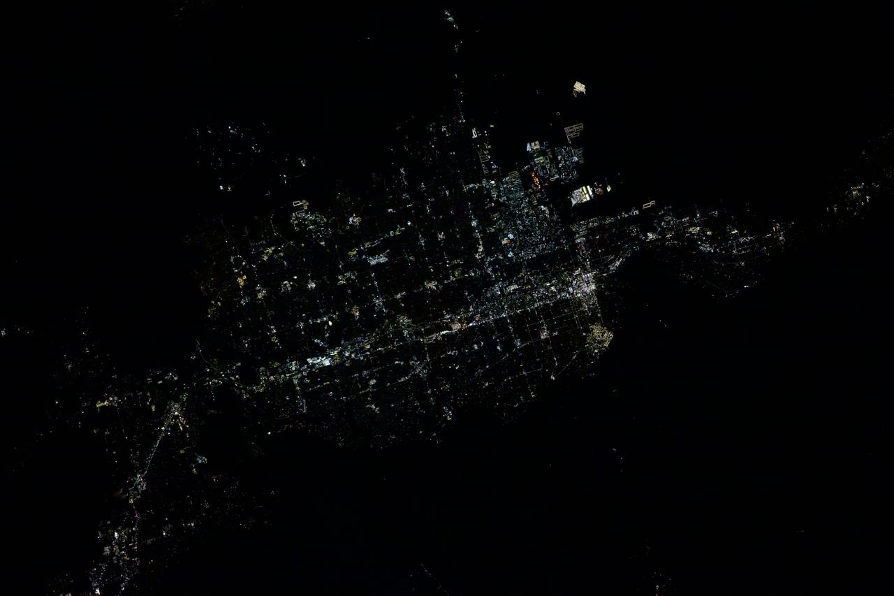
iss072e399194 (Dec. 19, 2024) --- The city lights of Salt Lake City, the capital of Utah, and its surrounding suburbs are pictured at about 5:17 a.m. local time from the International Space Station as it orbited 258 miles above.

ISS030-E-117431 (1 Feb. 2012) --- In the Columbus laboratory of the International Space Station, NASA astronaut Dan Burbank, Expedition 30 commander, enters data in a computer for the High Salt Diet protocol of the Sodium Loading in Microgravity (SOLO) experiment.
STS054-151-015 (13-19 Jan 1993) --- The Makgadikgadi Salt Pan is one of the largest features in Botswana visible from space. Any water that spills out of the Okavango Swamplands flows down to the Makgadikgadi where it evaporates. An ancient beach line can be seen as a smooth line around the west (left) side of the Pan. Orapa diamond mine can be detected due south of the pan as a small rectangle. The large geological feature known as the Great Dike of Zimbabwe can be seen far right. This large panorama shows clouds in southern Angola, Zambia and Zimbabwe in the distance.
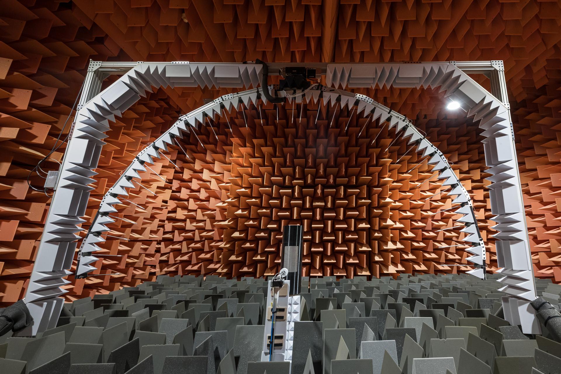
Scattering of Acoustically Lined Simplified Airframes (SALSA) Test with High Resolution Traversing Microphone Array (HiRTMA) in Structural Acoustics Loads and Transmission Facility (SALT) in Building 1208.
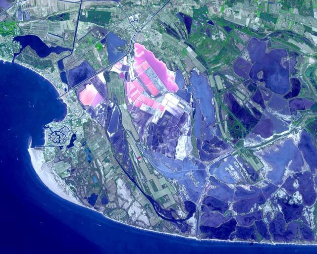
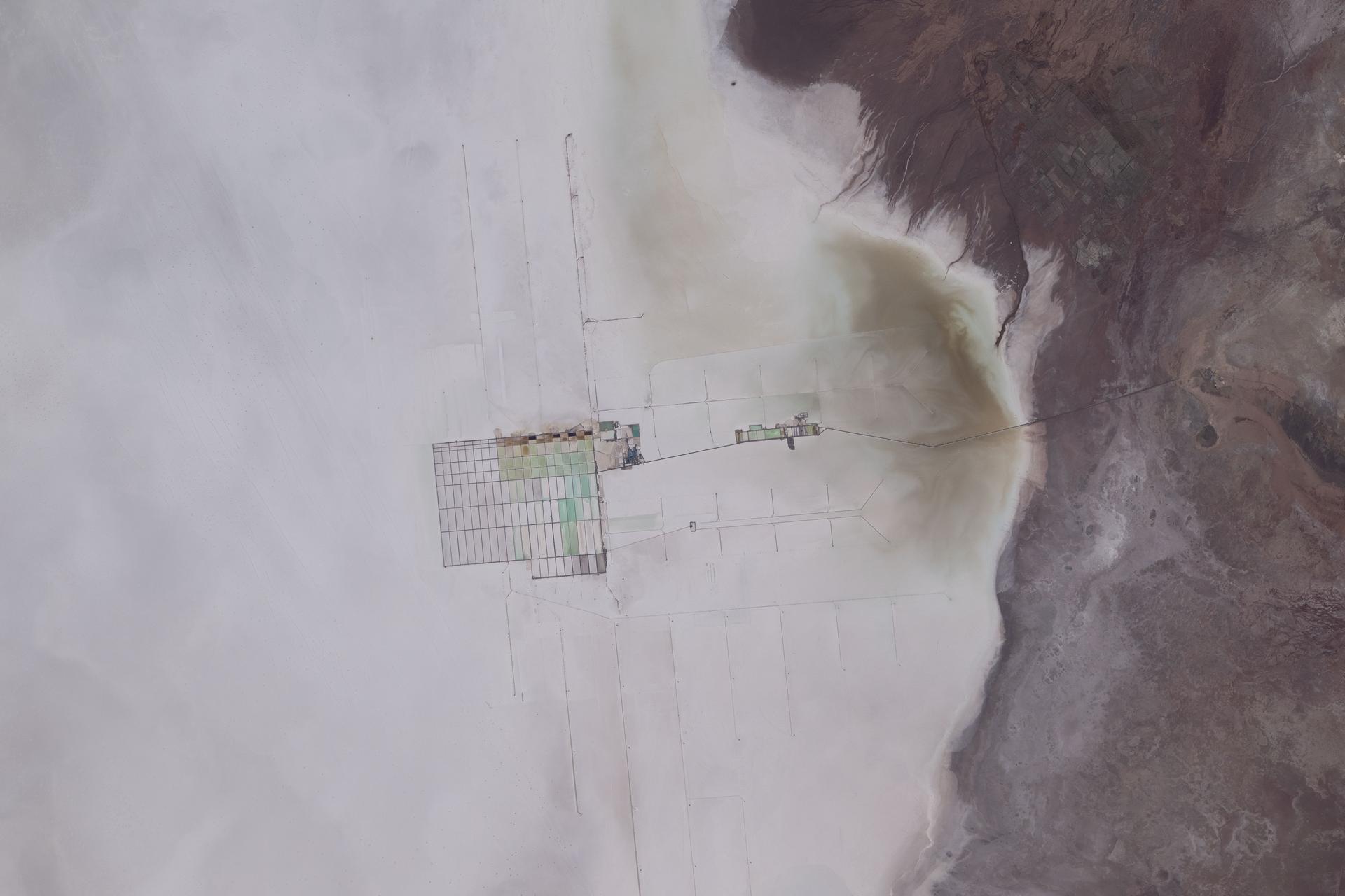
Salin-de-Giraud is a major center of salt production on the right bank of the Rhone River in southern France. Through evaporation of seawater, about one million tons of salt are produced every year. In addition, the recovery of sodium carbonate is key to the manufacture of the soap of Marseille. The image was acquired September 2, 2020, covers an area of 14.7 by 18.3 km, and is located at 43.4 degrees north, 4.7 degrees east. https://photojournal.jpl.nasa.gov/catalog/PIA26325
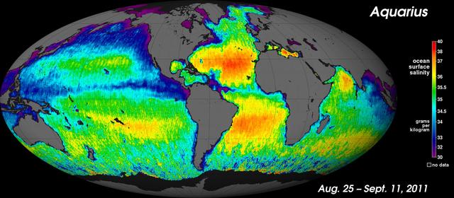
NASA Aquarius instrument has produced its first global map of the salinity, or saltiness, of Earth ocean surface, providing an early glimpse of the mission anticipated discoveries.
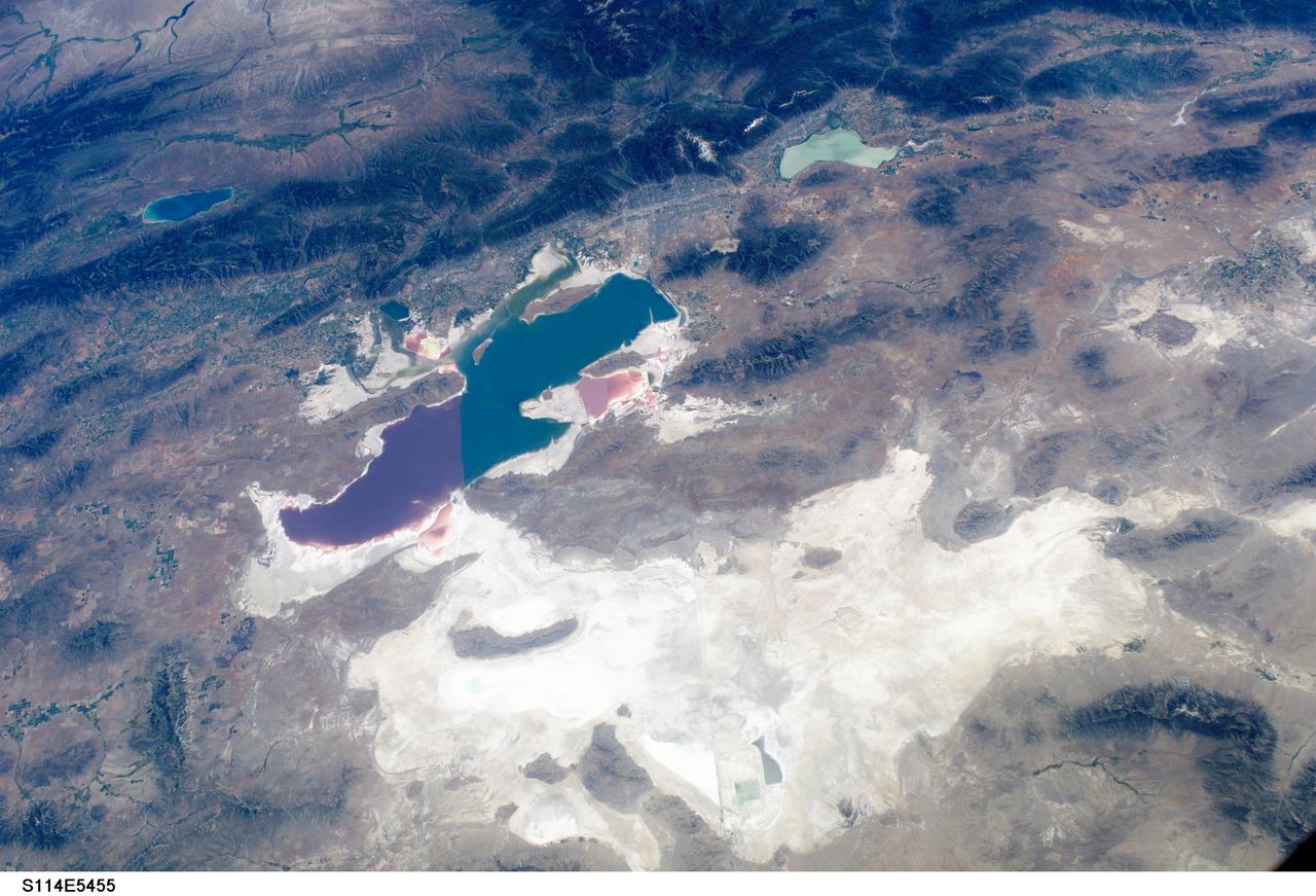
S114-E-5455 (27 July 2005) --- This digital still camera frame, showing the Great Salt Lake and Salt Lake City, is one of a series of photos of both domestic and world-wide targets of opportunity captured by the STS-114 astronauts. Salt Lake City is in the upper half of the photo between the Great Salt Lake and the smaller Lake Utah. A 28 mm lens was used to record the image.
Filled with briny lakes, the Quisquiro salt flat in South America's Altiplano represents the kind of landscape that scientists think may have existed in Gale Crater, which NASA's Curiosity rover is exploring. This salt flat is located in Chile, though the Altiplano sprawls across countries. Streams and rivers flowing from mountain ranges into this arid, high-altitude plateau lead to closed basins similar to Mars' ancient Gale Crater. Lakes on the Altiplano are heavily influenced by climate in the same way as Gale. https://photojournal.jpl.nasa.gov/catalog/PIA23374
Salt crystal formations
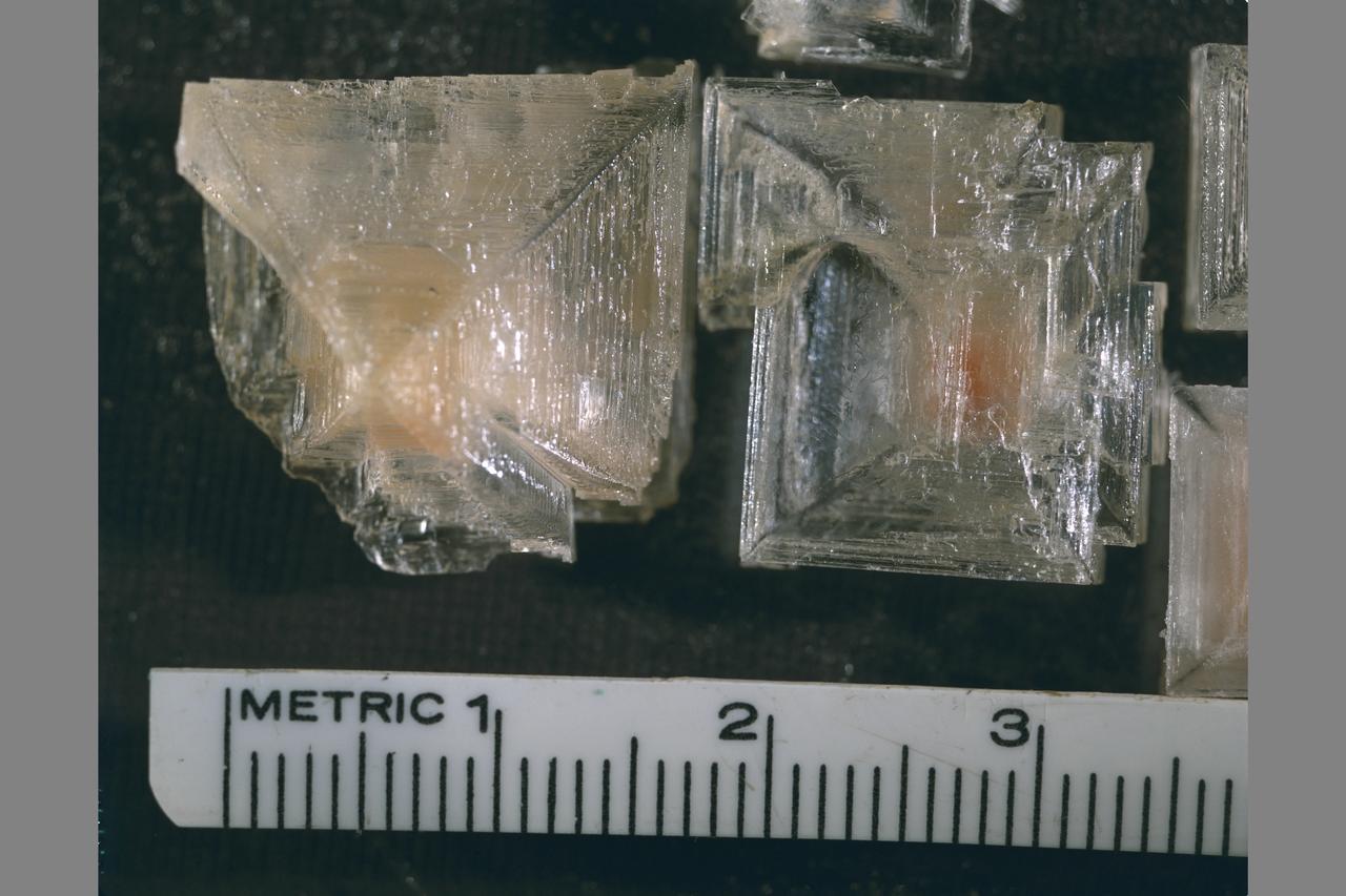
Salt crystal formations
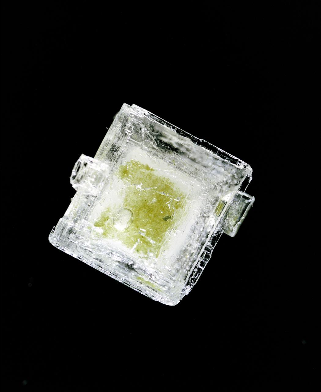
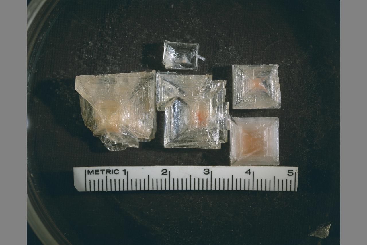
Hypersaline Cyanobacterial salt crystal

Lozenge-shaped crystals are evident in this magnified view of a Martian rock target called Mojave, taken on Nov. 15, 2014, by NASA Curiosity Mars rover. These features record concentration of dissolved salts, possibly in a drying lake.

Light-toned soil deposits might be widely distributed on the flanks and valley floors of the Columbia Hills region in Gusev Crater. The salts may record past presence of water, as they are easily mobilized and concentrated in liquid solution
The light corner of the image from NASA EarthKAM is Lake Torrens, an ephemeral salt lake in South Australia. The twisted strata visible here is part of a rocky desert area in the Australian Outback.
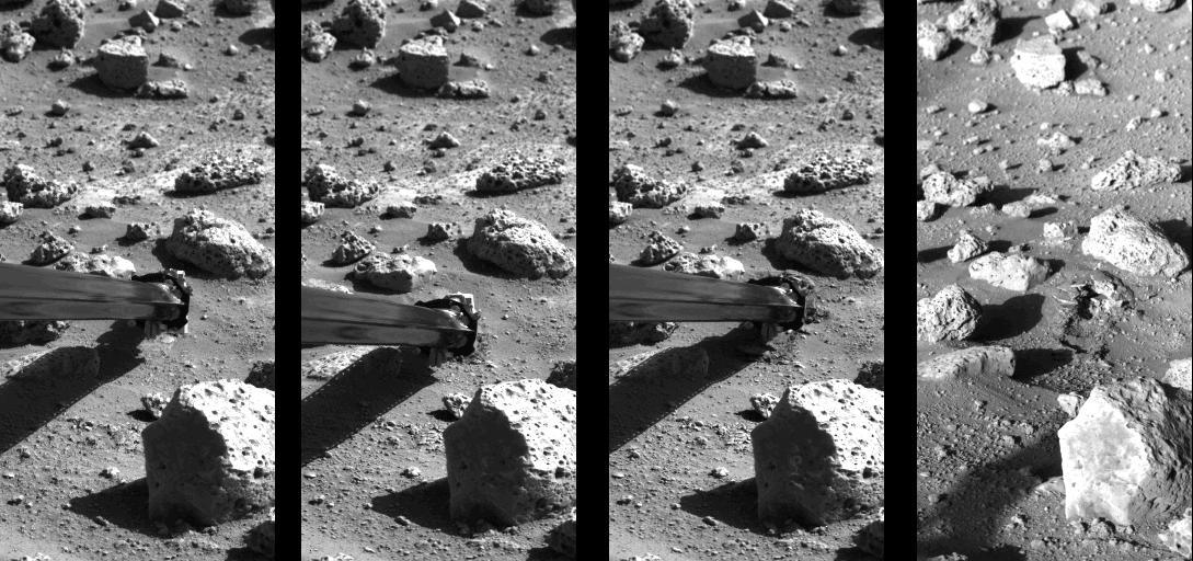
Operation of the surface sampler in obtaining Martian soil for NASA's Viking 2 molecular analysis experiment. Dubbed Bonneville Salt Flats, the exposure of thin crust appeared unique in contrast with surrounding materials. http://photojournal.jpl.nasa.gov/catalog/PIA00145
Lake Afrera is a hypersaline lake located in the Danakil Depression in northern Ethiopia where rock salt has been mined for centuries. This image was acquired by NASA Terra spacecraft.
Lake Eyre is a large salt lake situated between two deserts in one of Australia driest regions. These four images from NASA Terra spacecraft austral summers of 2000 and 2002.
Melas Chasma is the widest segment of Valles Marineris, the largest canyon in the Solar System as seen by Mars Reconnaissance Orbiter spacecraft. In this region, hydrated sulfate salts have been detected.
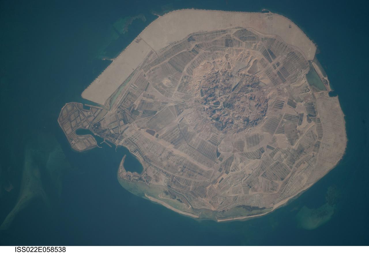
ISS022-E-058538 (31 Jan. 2010) --- Sir Bani Yas Island is featured in this image photographed by an Expedition 22 crew member on the International Space Station. Sir Bani Yas Island is located in the Persian Gulf near the western coastline of the United Arab Emirates (UAE). The approximately 14-kilometers x nine-kilometers island is the surface expression of a salt dome, and is one of several such islands in the Persian Gulf. During past periods of alternating wet and dry climate, sometimes involving areas with high rates of evaporation in enclosed basins, thick layers of salt minerals (such as halite ? common table salt, or gypsum ? a major component of wallboard) were deposited. These layers were subsequently buried by sediments; with enough overlaying material and depth of burial, the salt layers can begin to flow. Salt has lower density than the surrounding rock and it tends to flow upwards, pushing up the overlaying layers of rock to form a salt dome. While many salt domes retain a cap of the youngest rock layers at the surface, in some cases the underlaying salt extrudes onto the surface. This photograph illustrates the varying character of surfaces on the island. The central mountains of Jebel Wahid (center) mark the location of the Sir Bani Yas salt dome. The dome has breached the surface but exposed salt - primarily gypsum - is removed by erosion, leaving a rugged, insoluble cap formed from fragments of the overlaying sedimentary and volcanic rocks. Sand and silt derived from the Jebel Wahid area and surrounding gravel cover forms beaches along the outer edge of the island.
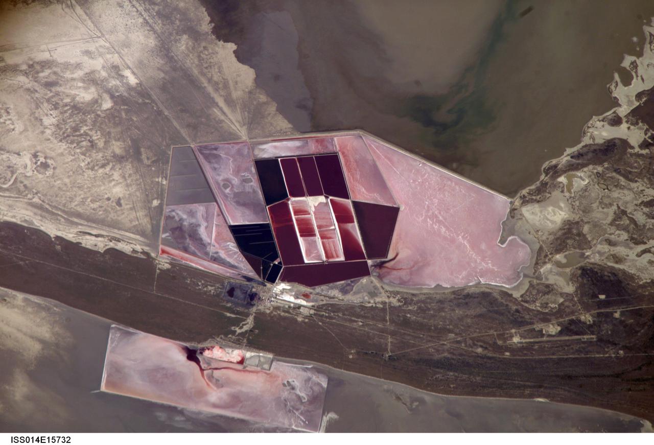
ISS014-E-15732 (1 March 2007) --- Salt ponds of Botswana are featured in this image photographed by an Expedition 14 crewmember on the International Space Station. This recent, detailed view shows the salt ponds of one of Africa's major producers of soda ash (sodium carbonate) and salt. Soda ash is used for glass making, in metallurgy, in the detergent industry, and in chemical manufacture. The image shows a small part of the great salt flats of central Botswana known as the Makgadikgadi Salt Pans. The soda ash and salt are both mainly exported (since 1989) to most countries in southern and central Africa. Brines from just beneath the pan floor are evaporated to produce the soda ash and salt -- a process for which the semiarid climate of Botswana is ideal. Red salt-loving algae in the ponds indicate that the salinity of the evaporating brines is medium to high. The salt pans of Botswana--a prominent visual photo target of interest for astronauts aboard the station--lie at the low point of a vast shallow continental basin. Rivers draining from as far away as central Angola - more than 1,000 kilometers away - supply water to the pans. According to scientists, during several wet climatic phases in the recent geological past the pans were permanently filled with water, for thousands of years, only to dry out when climates fluctuated to drier conditions. During dry phases water only reaches the pans underground. These are the brines that support the ash and salt industry. During wet phases when open water exists, beach ridges are constructed by wave action. One of these crosses the lower part of the view.
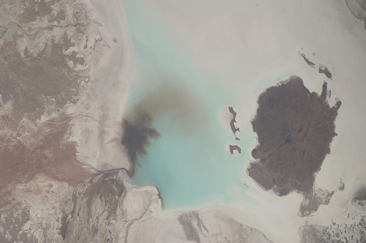
iss073e0248069 (June 24, 2025) --- Lake Coipasa, a basin created by tectonic activity with a high salt concentration surrounded by the Coipasa Salt Flats, in Bolivia near the border with Chile is pictured from the International Space Station as it orbited 264 miles above South America. The volcano Wila Pukarini (upper right) is located inside the lake.

ISS010-E-06681 (12 November 2004) --- Shark Bay, Australia is featured in this image photographed by an Expedition 10 crewmember on the International Space Station (ISS). This image shows large solar salt works developed in Useless Loop and Useless Inlet, Shark Bay, Western Australia. The salt (sodium chloride) is produced when ponds are repeatedly flooded with seawater, which is progressively concentrated by evaporation. This particular salt farm opened in 1967 and expanded operations in the 1990s. Today, this salt farm comprises over 50 ponds, the newest pond in the outermost pond in Useless Inlet, which provides the first evaporation cycle to increase the salinity of the water prior to entering the next pond. Complex chemical and biological adjustments occur in the system each time the configuration of ponds is changed.
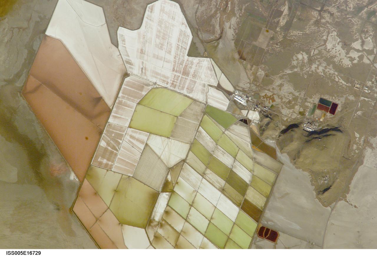
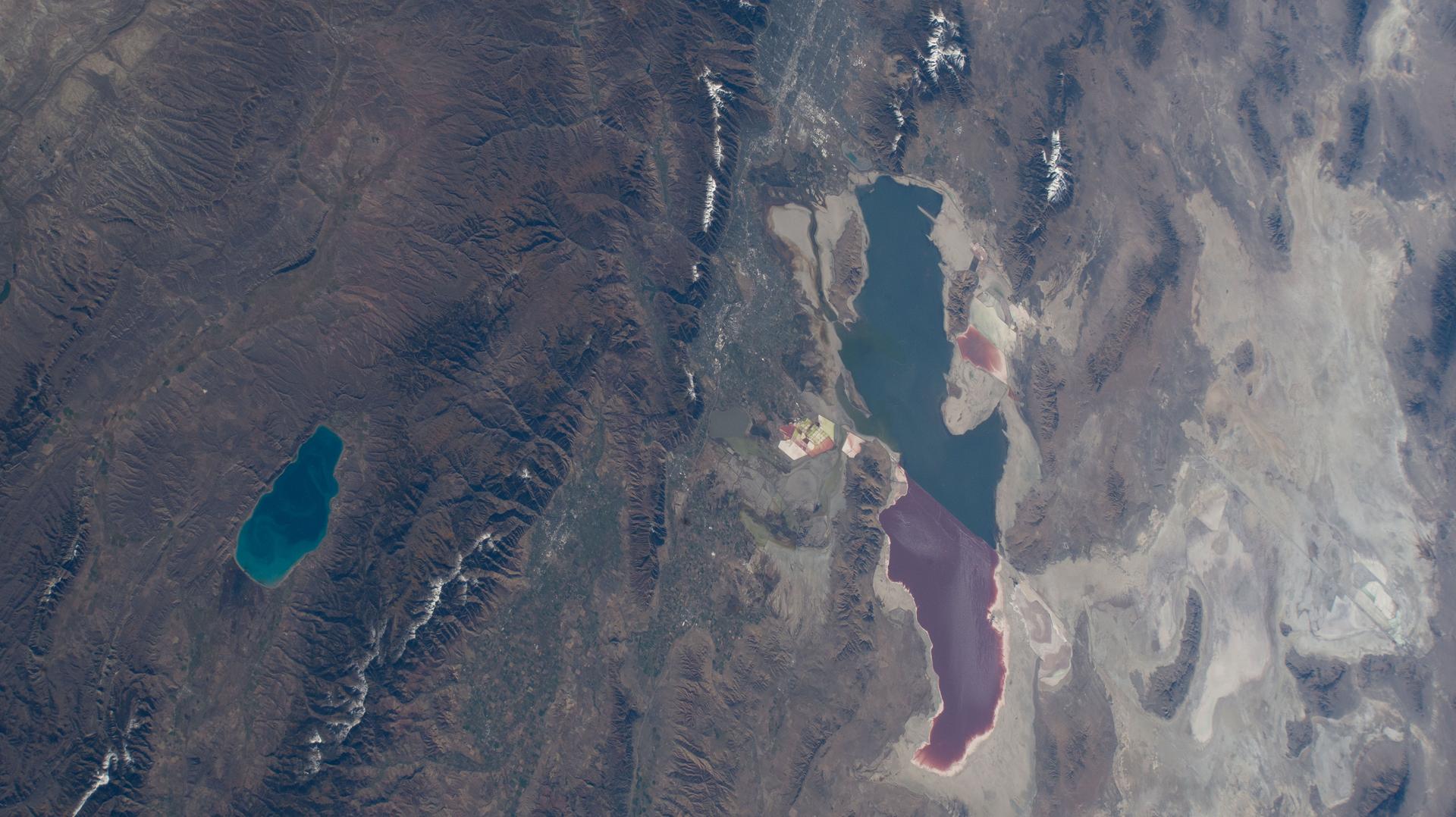
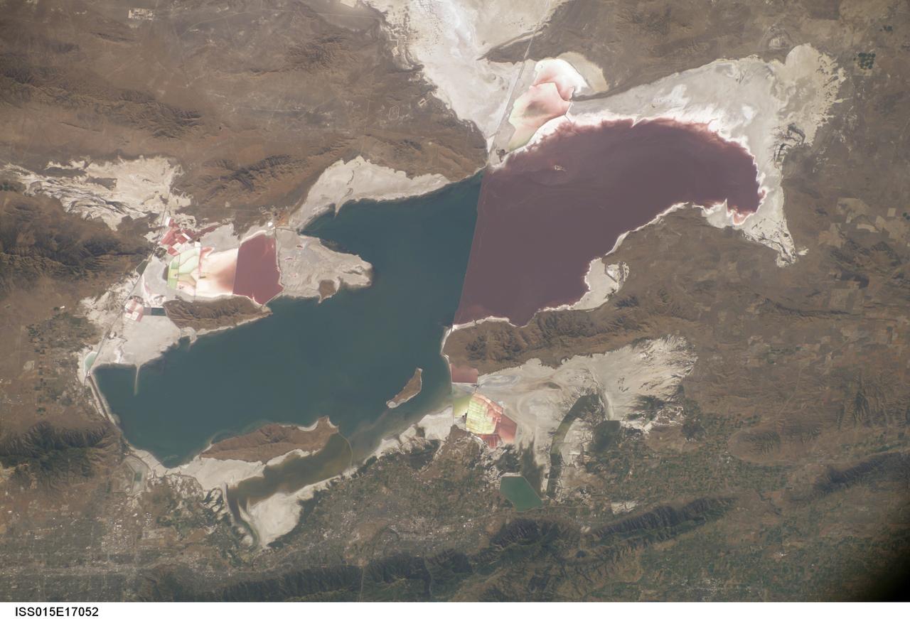
ISS005-E-16729 (7 October 2002) --- Great Salt Lake, Utah, is featured in this image photographed by an Expedition 5 crewmember on the International Space Station (ISS). Great Salt Lake serves as a striking visual marker for crewmembers orbiting over North America. A sharp line across its center is caused by the restriction in water flow from the railroad causeway. The eye-catching colors of the lake stem from the fact that Great Salt Lake is hyper saline, typically 3-5 times saltier than the ocean, and the high salinities support sets of plants and animals that affect the light-absorbing qualities of the water. North of the causeway salinities are higher, and the water turns red from the pigments of halophilic bacteria. In the shallower corner of the lake, earthen dikes mark large salt evaporation works, which take on the jewel tones of turquoise, russet, tamber and pearl white.
This image from NASA Mars Reconnaissance Orbiter shows chlorides that have a bright appearance and are covered by other dark materials.
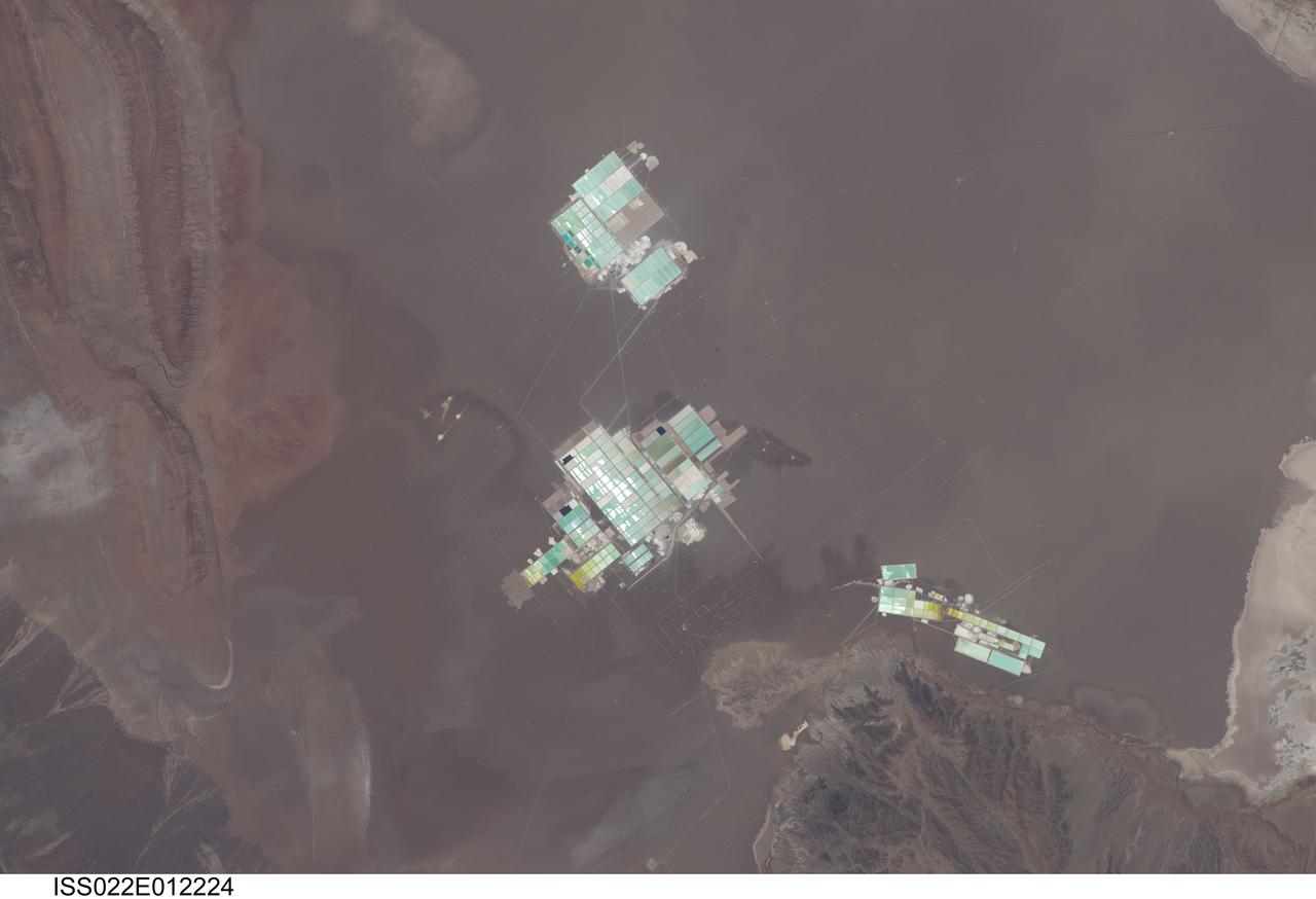
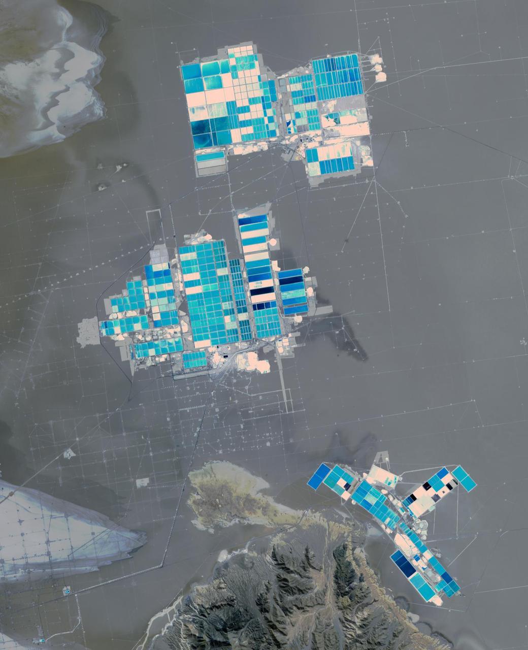
ISS022-E-012224 (15 Dec. 2009) --- Evaporation ponds in the Salar de Atacama, Chile are featured in this image photographed by an Expedition 22 crew member on the International Space Station. The Salar (salt flat) de Atacama in Chile is an enclosed basin with no drainage outlets. While the grey-brown surface of the Salar is flat and desiccated, mineral-rich brines - water with a high percentage of dissolved salts - are located below the surface. The subsurface brines of the Salar de Atacama are particularly rich in lithium salts. Lithium is an essential component of advanced batteries and medicines, among many other uses. The brines are pumped to the surface through a network of wells and into large shallow evaporation ponds ? three such evaporation pond facilities are visible in the center of the image. Color variations in the ponds are due to varying amounts of salts relative to water. The dry and windy climate enhances evaporation of the water, leaving concentrated salts behind for extraction of the lithium. The Salar de Atacama is located in the southern half of the Atacama Desert ? with no historical or current records of rainfall in some parts of this desert, it is considered to be one of the driest places on Earth. This photograph illustrates the central portion of the Salar de Atacama. It is bounded by brown to grey-brown folded and faulted strata of the Cordillera de la Sal to the northwest (upper left) and darker bedrock of the Cordon de Lila to the south (lower right).
ISS033-E-006202 (20 Sept. 2012) --- Salar de Coipasa, Bolivia is featured in this image photographed by an Expedition 33 crew member on the International Space Station. The Salar de Coipasa, located in the Altiplano region of western Bolivia, covers an area of approximately 2,500 square kilometers. The word ?salar? describes arid closed basins in which evaporation of mineral-rich waters leads to the formation of thick, flat-laying salt deposits. Salar de Coipasa is located to the southwest of the saline Lake Poopo and northwest of the largest salt flat in the world, Salar de Uyuni. At Coipasa, a crust composed of halite?common table salt?provides the brilliant white coloration characteristic of the Altiplano salars (right). While the environment of Salar de Coipasa is arid, it does receive constant water from the Lauca River flowing from the north; this feeds Lake (Lago) Coipasa that fills the northern end of the basin with shallow water (center). However, the water flow can drop off sharply during periods of drought. The waters of Lake Coipasa, and the white salt crust of the salar, also serve to highlight dark river sediments flowing into the basin along the northeastern shore. Dark volcanic rocks contrast sharply with the surrounding salt crust at right. While the western Andes Mountains contain many active volcanoes, the nearby Tata Sabaya volcano has not been historically active.
Earth Observations taken by Expedition 38 crewmember. Crewmember indicates Salt Lake City,Utah. Image was released by astronaut on Twitter.

Salt tolerant plants studied as source of alternative aviation fuel in the Green Lab Research Facility - Salicornia Virginica
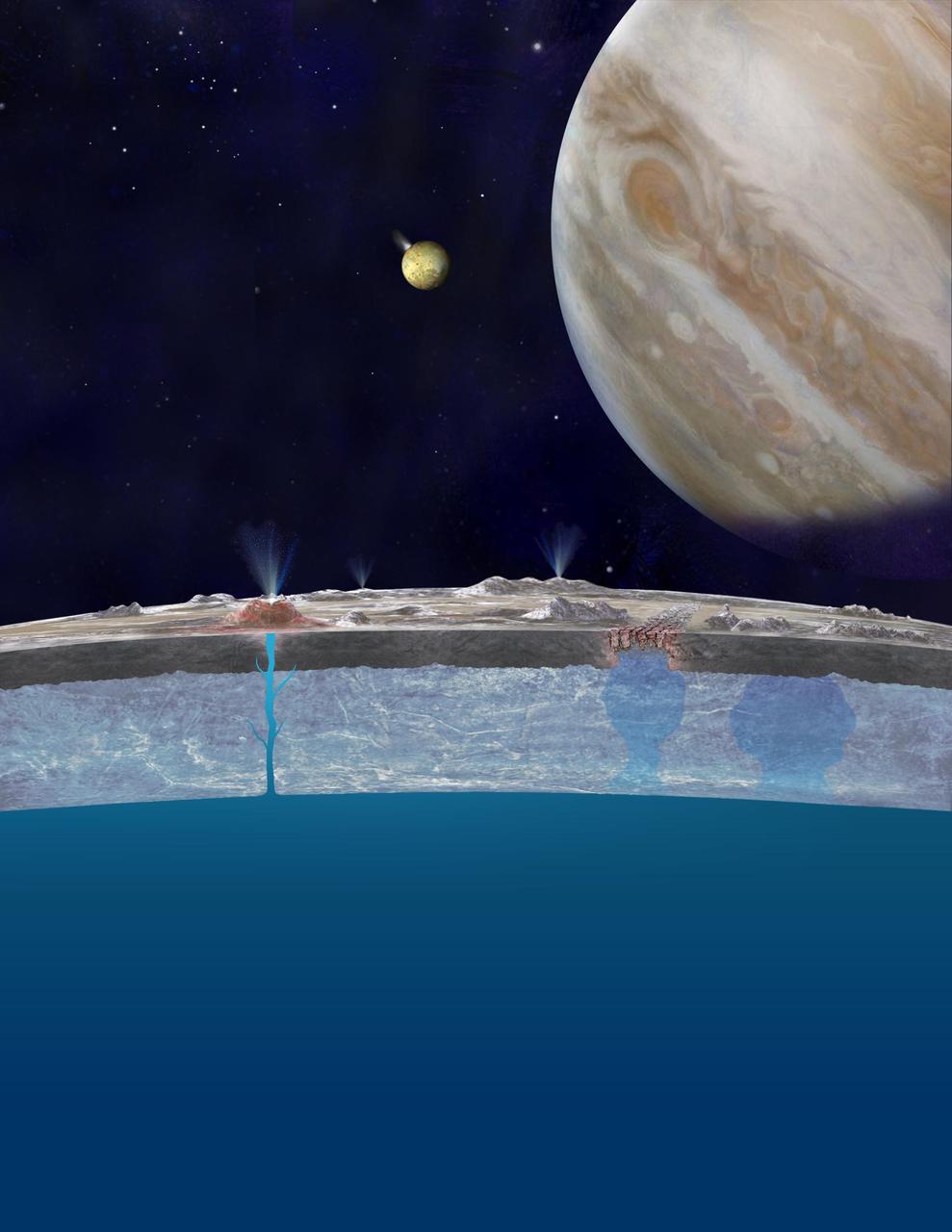
Based on new evidence from Jupiter moon Europa, astronomers hypothesize that chloride salts bubble up from its global liquid ocean and reach the frozen surface where they are bombarded with sulfur from volcanoes on Jupiter innermost large moon, Io.
iss071e673954 (Sept. 15, 2024) --- West Taijinar salt lake in China is pictured from the International Space Station as it orbited 260 miles above the Asian nation.
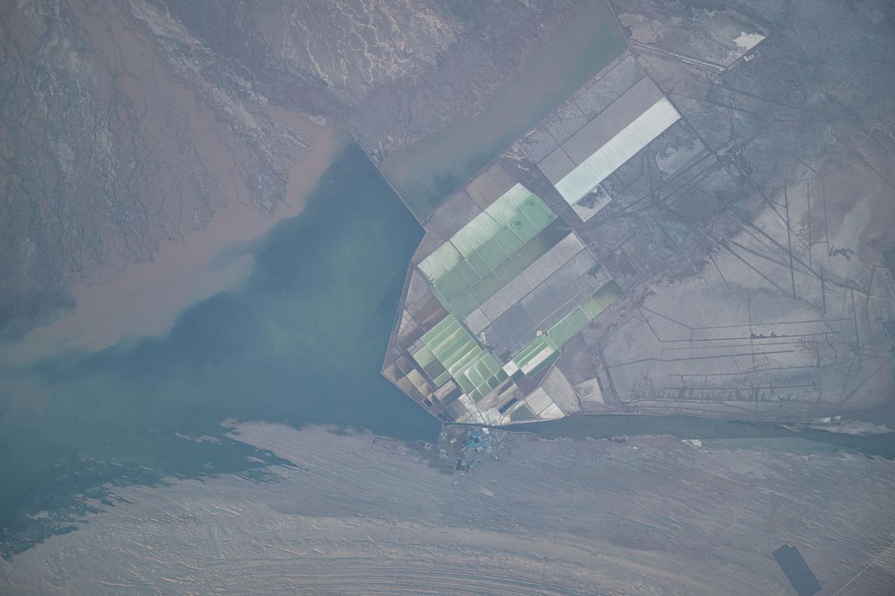
ISS015-E-17052 (5 July 2007) --- The Great Salt Lake in Utah is featured in this image photographed by an Expedition 15 crewmember on the International Space Station.
ISS030-E-034228 (14 Jan. 2012) --- The Great Salt Lake in Utah serves as a striking visual marker for the Expedition 30 crew members orbiting over the western states aboard the International Space Station. A sharp line across the lake's center is caused by the restriction in water flow from the railroad causeway. The eye-catching colors of the lake stem from the fact that Great Salt Lake is hypersaline, typically 3-5 times saltier than the ocean.
S135-E-006466 (9 July 2011) --- As in the case of many previous space missions, the Great Salt Lake in Utah serves as a striking visual marker for the STS-135 astronauts orbiting over North America in the space shuttle Atlantis. A sharp line across the lake's center is caused by the restriction in water flow from the railroad causeway. The eye-catching colors of the lake stem from the fact that Great Salt Lake is hypersaline, typically 3-5 times saltier than the ocean. Photo credit: NASA

Dr. Luz M. Calle, a principal investigator for corrosion research at NASA’s Kennedy Space Center, shows a dish of crystals left over from an experiment to separate salt from water Dec. 12, 2018. Astronauts traveling on long-duration missions in space will need to recycle water, which means having to remove salt and other chemicals from wastewater to turn it back into drinking water.
iss069e033759 (July 17, 2023) -- As the International Space Station orbited 260 miles above Turkey, NASA astronaut Woody Hoburg captured this image of Lake Tuz—a disappearing lake that was once the second-largest in the country. During some summers, the salt lake completely dries up, leaving the off-white appearance of higher concentrations of salt and minerals. What's left of the lake experiences seasonal color changes due to algae blooms, like the deep red shown near the bottom center of the image.

ISS007-E-07360 (14 June 2003) --- This regional view of Salt Lake City, Utah taken by an Expedition 7 crewmember onboard the International Space Station (ISS) shows the city and its suburbs nestled between the Wasatch Front and the Great Salt Lake. The core of Interstate Highway 15 runs North-South through the valley, with suburbs arrayed east and west of the highway. An important issue facing Salt Lake City’s growing population is preservation and allocation of water resources. Utah is in its fifth year of drought. One of the most dramatic effects of the drought visible in this picture is the fact that the lake levels are so low that Antelope Island is separated from the mainland by dry lakebed. Expansive productive wetlands occur where freshwater flows from the Wasatch Range and into the lake. The southern end of this network of wetlands can be seen in the image.

This false-color mosaic, made from infrared data collected by NASA Cassini spacecraft, reveals the differences in the composition of surface materials around hydrocarbon lakes at Titan, Saturn largest moon.
This composite image of the Jupiter-facing hemisphere of Europa was obtained on Nov. 25, 1999 by NASA Galileo spacecraft. Blue areas show cleanest, brightest icy surfaces, while the red areas have the highest concentrations of darker, non-ice materials.
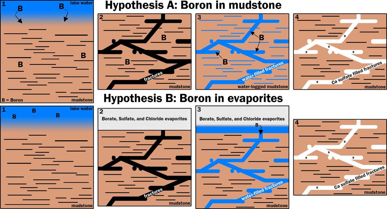
This graphic portrays two hypotheses about how the element boron ended up in calcium sulfate veins found within mudstone layers of the Murray formation on Mars' lower Mount Sharp. Hypothesis A is presented left-to-right in the upper four panels; hypothesis B in the lower four. Note that the two final panels are identical, depicting conditions found by NASA's Curiosity Mars rover. Calcium sulfate is the veins' main ingredient. The mudstone matrix around the veins resulted from deposition of sediments in a lake environment in Mars' Gale Crater billions of years ago. In hypothesis A: (1) Boron dissolved in the lake and was incorporated into the lake bottom clays that became the Murray formation. (2) The lake then dried and the bedrock fractured. (3) Later groundwater interacted with the clays under conditions that released the boron into the groundwater. (4) Then, the boron was deposited along with the calcium sulfate that makes up the bulk of these veins. In hypothesis B: (1) Boron was not incorporated into the clays as the lake was active. (2) Instead, when the lake dried out, it left a layer of boron-containing salts, and likely other types of salts, such as sodium chloride (table salt) and calcium sulfates, in an overlying layer that Curiosity has not yet visited. The bedrock fractured. (3) Groundwater later dissolved this layer of evaporite salts and moved the salts down into the older layers the rover has investigated. (4) The groundwater deposited the evaporite salts with the calcium sulfate that makes up the bulk of these veins. http://photojournal.jpl.nasa.gov/catalog/PIA21253
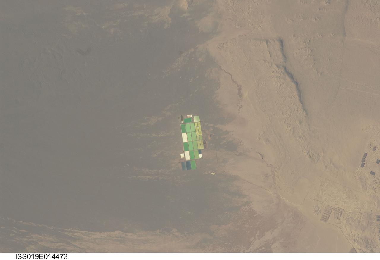
ISS019-E-014473 (5 May 2009) --- Salt ponds in Nueva Victoria, northern Chile are featured in this image photographed by an Expedition 19 crew member on the International Space Station. This view shows a long alluvial fan, sloping from east to west (left to right) in northern Chile with solar evaporation (or salt) ponds, some brightly colored, near the foot of the fan. The alluvial fan sediments are brown and contrast sharply with tan sediments of the Pampa del Tamarugal, the great hyper arid inner valley of Chile?s northern Atacama Desert. Nitrates and many other minerals are mined in this region. A few extraction pits and ore dumps are visible at bottom right, but most of the shallow diggings (0.5?5 meters deep) of a mine extracting caliche deposits ? a hard, cemented layer in the soil formed by downward movement and redeposition of sodium salts ? lie just outside the picture. Iodine is one of the products from mining; it is first extracted by a process known as heap leaching. Waste liquids from the iodine plants are dried in the tan and brightly colored evaporation ponds to crystallize nitrate salts for collection. Fertilizer production for higher-value crops is the main use for the recovered nitrates, but there are many other uses including the manufacture of pharmaceuticals, explosives, glass, ceramics, water treatment and metallurgical processes.
iss065e258021 (Aug. 16, 2021) --- The International Space Station was orbiting 264 miles above the northwestern United States when this photograph was taken. Near bottom right, is the Great Salt Lake in the Beehive State of Utah.

ISS031-E-012199 (5 May 2012) --- NASA astronaut Don Pettit, Expedition 31 flight engineer, holds a liquid salt dispenser and chop sticks near the galley in the Unity node of the International Space Station.
iss069e000174 (March 31, 2023) --- Salt lakes in southern China near the Himalayas are pictured by an external high definition camera on the International Space Station as it orbited 261 miles above.
iss070e008872 (Oct. 24, 2023) --- Lake Tyrell, the largest salt lake in the Australian province of Victoria, is pictured from the International Space Station as it orbited 266 miles above.
41D-42-045 (30 Aug-5 Sept 1984) --- Lake Carnegie in western Australia, 600 miles northeast of Perth. This is an island basin dotted with numerous salt lakes, ponds, flats, benches, and dunes.
iss070e005945 (Oct. 19, 2023) --- Lake Elton, a salt lake in Russia near the western border of Kazakhstan, is pictured from the International Space Station as it orbited 260 miles above.
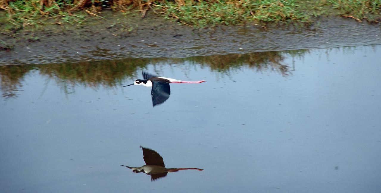
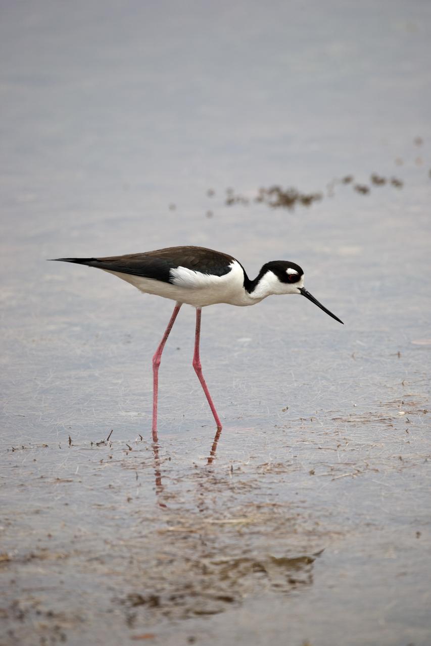
CAPE CANAVERAL, Fla. – A black-necked stilt skims across the drainage canal behind the NASA News Center at NASA's Kennedy Space Center in Florida. The species inhabits salt marshes and coastal bays in the East, ranging along the Atlantic Coast from Delaware and the Carolinas to northern South America. Kennedy shares a boundary with the Merritt Island National Wildlife Refuge that includes salt-water estuaries, brackish marshes, hardwood hammocks and pine flatwoods. The diverse landscape provides habitat for more than 310 species of birds, 25 mammals, 117 fishes and 65 amphibians and reptiles. Photo credit: NASA/Ben Smegelsky
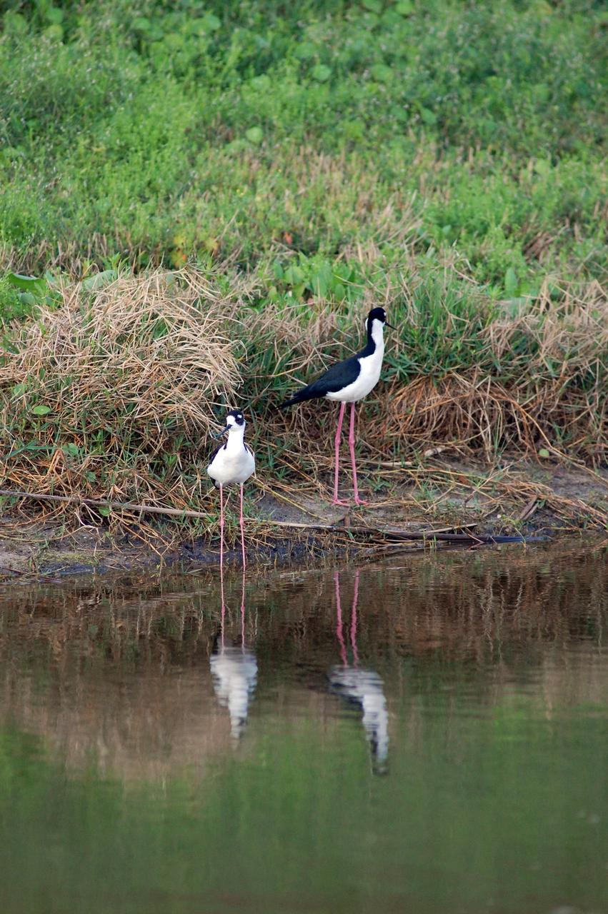
CAPE CANAVERAL, Fla. –Black-necked stilts move onto the bank of the Turn Basin behind the NASA News Center at NASA's Kennedy Space Center in Florida. The species inhabits salt marshes and coastal bays in the East, ranging along the Atlantic Coast from Delaware and the Carolinas to northern South America. Kennedy shares a boundary with the Merritt Island National Wildlife Refuge that includes salt-water estuaries, brackish marshes, hardwood hammocks and pine flatwoods. The diverse landscape provides habitat for more than 310 species of birds, 25 mammals, 117 fishes and 65 amphibians and reptiles. Photo credit: NASA/Ben Smegelsky
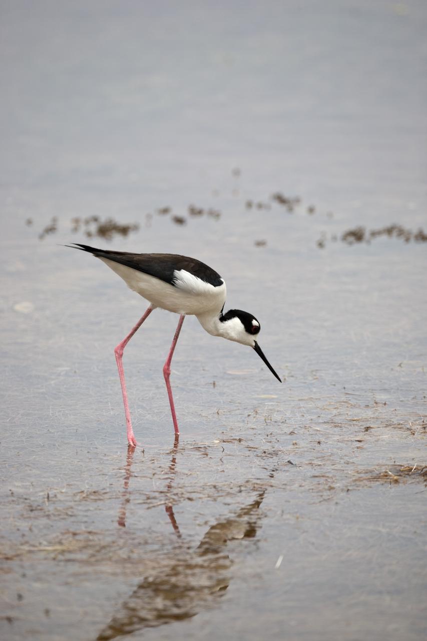
CAPE CANAVERAL, Fla. –– A black-necked stilt searches the shallow water for food at NASA's Kennedy Space Center in Florida. The species inhabits salt marshes and coastal bays in the East, ranging along the Atlantic Coast from Delaware and the Carolinas to northern South America. Kennedy shares a boundary with the Merritt Island National Wildlife Refuge that includes salt-water estuaries, brackish marshes, hardwood hammocks and pine flatwoods. The diverse landscape provides habitat for more than 310 species of birds, 25 mammals, 117 fishes and 65 amphibians and reptiles. Photo credit: NASA/Dimitri Gerondidakis
ISS040-E-043231 (6 July 2014) --- As in the case of many previous space missions, the Great Salt Lake in Utah serves as a striking visual marker for the Expedition 40 crew members orbiting 222 nautical miles over North America aboard the International Space Station. A 200mm focal length was used to capture the image. A sharp line across the lake's center is caused by the restriction in water flow from the railroad causeway. The eye-catching colors of the lake stem from the fact that Great Salt Lake is hypersaline, typically 3-5 times saltier than the ocean.
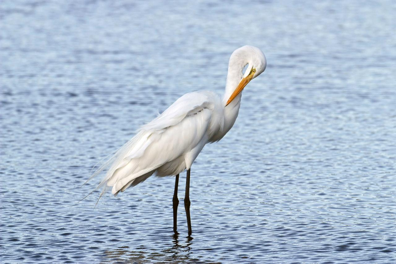
CAPE CANAVERAL, Fla. – A great egret preens its feathers while standing in the shallow water of a pond in the Merritt island National Wildlife Refuge, which borders NASA's Kennedy Space Center in Florida. The breed feeds alone, stalking fish, frogs, snakes and crayfish in shallow water. They inhabit freshwater and salt marshes, marshy ponds and tidal flats. The center shares a boundary with the refuge that includes salt-water estuaries, brackish marshes, hardwood hammocks and pine flatwoods. The diverse landscape provides habitat for more than 310 species of birds, 25 mammals, 117 fishes and 65 amphibians and reptiles. Photo credit: NASA/Jim Grossmann
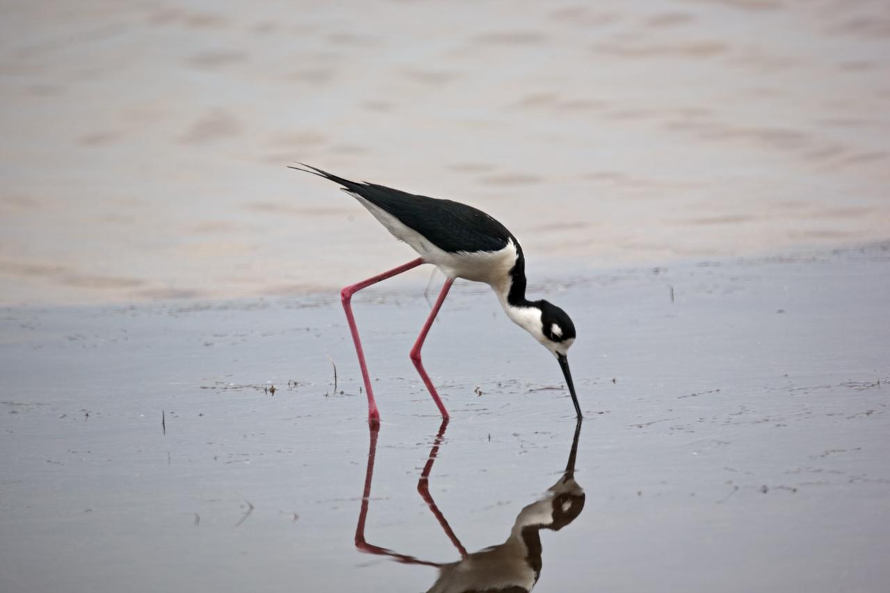
CAPE CANAVERAL, Fla. –– A black-necked stilt finds food in the shallow water at NASA's Kennedy Space Center in Florida. The species inhabits salt marshes and coastal bays in the East, ranging along the Atlantic Coast from Delaware and the Carolinas to northern South America. Kennedy shares a boundary with the Merritt Island National Wildlife Refuge that includes salt-water estuaries, brackish marshes, hardwood hammocks and pine flatwoods. The diverse landscape provides habitat for more than 310 species of birds, 25 mammals, 117 fishes and 65 amphibians and reptiles. Photo credit: NASA/Dimitri Gerondidakis
CAPE CANAVERAL, Fla. –– A black-necked stilt searches the shallow water for food at NASA's Kennedy Space Center in Florida. The species inhabits salt marshes and coastal bays in the East, ranging along the Atlantic Coast from Delaware and the Carolinas to northern South America. Kennedy shares a boundary with the Merritt Island National Wildlife Refuge that includes salt-water estuaries, brackish marshes, hardwood hammocks and pine flatwoods. The diverse landscape provides habitat for more than 310 species of birds, 25 mammals, 117 fishes and 65 amphibians and reptiles. Photo credit: NASA/Dimitri Gerondidakis
ISS040-E-043230 (6 July 2014) --- As in the case of many previous space missions, the Great Salt Lake in Utah serves as a striking visual marker for the Expedition 40 crew members orbiting 222 nautical miles over North America aboard the International Space Station. A 200mm focal length was used to capture the image. A sharp line across the lake's center is caused by the restriction in water flow from the railroad causeway. The eye-catching colors of the lake stem from the fact that Great Salt Lake is hypersaline, typically 3-5 times saltier than the ocean.
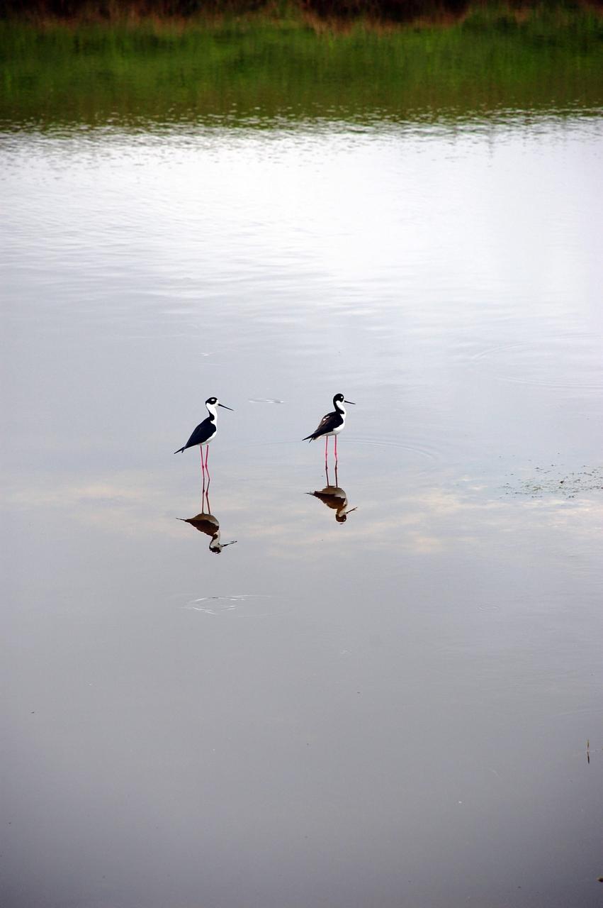
CAPE CANAVERAL, Fla. –Black-necked stilts look as if they're doing handstands on their mirror images in the shallow water of the Turn Basin behind the NASA News Center at NASA's Kennedy Space Center in Florida. The species inhabits salt marshes and coastal bays in the East, ranging along the Atlantic Coast from Delaware and the Carolinas to northern South America. Kennedy shares a boundary with the Merritt Island National Wildlife Refuge that includes salt-water estuaries, brackish marshes, hardwood hammocks and pine flatwoods. The diverse landscape provides habitat for more than 310 species of birds, 25 mammals, 117 fishes and 65 amphibians and reptiles. Photo credit: NASA/Ben Smegelsky
S65-63830 (5 Dec. 1965) --- Algeria, south-southeast of the Colomb Bechar area, as seen from the National Aeronautics and Space Administration's Gemini-7 spacecraft. Sand dunes are 200 to 300 feet high in the Grand Erg Occidental area. The Quod Sacura River can be seen in the upper left corner. The white spot in the middle of the picture is the Sebcha el Malah salt beds. It should be noted that the area had just experienced very heavy rains (first in many years) and the stream and salt flat are inundated. This photograph was taken with a modified 70mm Hasselblad camera, with Eastman Kodak, Ektachrome MS (S.O. 217) color film. Photo credit: NASA
ISS030-E-009271 (5 Dec. 2011) --- Lake Eyre floods in South Australia are featured in this image photographed by an Expedition 30 crew member on the International Space Station. Heavy rain in early March 2011 produced the comparatively unusual event of water entering Lake Eyre. The southernmost and deepest lobes, Belt Bay and Lake Eyre South, were filled first. In this northeast-looking view from the space station, water can be seen in the southern basins of Lake Eyre, especially in Belt Bay where it appears green, and in Madigan Gulf where it appears in shades of pink and red. Despite some cloud, water is also apparent in narrow Jackboot Bay and at the estuary where Cooper Creek, one of the most important inflow rivers, fills a small, dark green lake. The varying water colors result from the effects of water depth and resident organisms. The green coloration of Belt Bay is likely related to its depth, which was reported in early December 2011 to be just less than one meter. The red color of Madigan Bay on the other hand, appears to be related to salt-loving bacteria. At half the depth of Belt Bay (0.4 meters), evaporation had apparently raised salt concentrations high enough to allow salt-loving bacteria to flourish when this image was taken. In Australian lake waters with salinities from about 30 percent upwards the majority of microbes are haloarchaea. The density of microbes that live in Australia?s salt lakes can reach 10⁷ ? 10⁸ cells/milliliters?so dense in fact, that the pink-red carotenoid pigments in the cell membranes appear to color the water. By August 2011 more than half the lake floor was covered by shallow water, with local creeks continuing to deliver water to the lake. Lake Eyre is an internal drainage basin, which means that all the water accumulates in the lake since it has no outlet to the sea. Any water that reaches the lake evaporates in the course of subsequent months. Water levels were reported to be falling everywhere in late 2011, when this image was acquired. The bright white salt of the floor of Lake Eyre South shows that this lake is entirely dry.
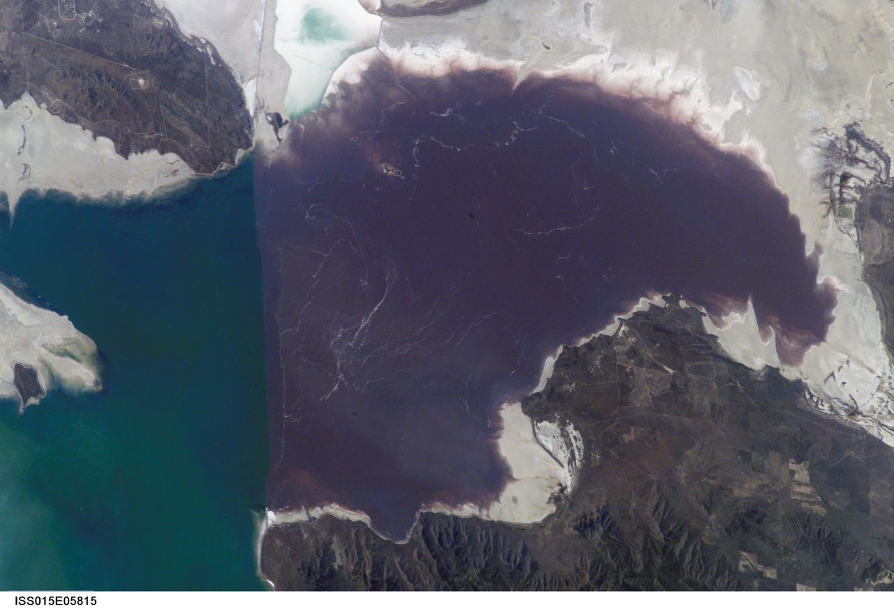
ISS015-E-05815 (30 April 2007) --- Algae in Great Salt Lake, Utah is featured in this image photographed by an Expedition 15 crewmember on the International Space Station. According to scientists, the Great Salt Lake of northern Utah is a remnant of glacial Lake Bonneville that extended over much of present-day western Utah, and into the neighboring states of Nevada and Idaho, approximately 32,000 to 14,000 years ago. During this time, the peaks of adjacent ranges such as the Promontory and Lakeside Mountains were most likely islands. As climate warmed and precipitation decreased in the region, glaciers that fed melt-water to Lake Bonneville disappeared, and the lake began to dry up. The present-day Great Salt Lake is a terminal lake in that water does not flow out of the lake basin. Water loss through the year is due primarily to evaporation, and when this loss exceeds input of water from rivers, streams, precipitation, and groundwater the lake level decreases. This is particularly evident during droughts. This process of evaporation, together with the relatively shallow water levels (maximum lake depth is around 33 feet), has led to increased salinity (dissolved salt content) of the lake waters. The north arm of the Lake, displayed in this image, typically has twice the salinity of the rest of the lake due to impoundment of water by a railroad causeway that crosses the lake from east to west. This restriction of water flow has led to a striking division in the types of algae and bacteria found in the north and south arms of the lake. In the northern arm (north of the causeway), the red algae Dunaliella Salina and the bacterial species Halo bacterium produce a pronounced reddish cast to the water, whereas the south arm (south of the causeway) is dominated by green algae such as Dunaliella viridis. The Great Salt Lake also supports brine shrimp and brine flies; and is a major stopover point for migratory birds including avocets, stilts, and plovers.
iss073e0343910 (July 19, 2025) --- Israel's Sea of Galilee, the lowest freshwater lake in the world and the second-lowest lake in the world after Israel's Dead Sea, a salt lake, is pictured from the International Space Station as it orbited 260 miles above the Middle East. Credit: Roscosmos
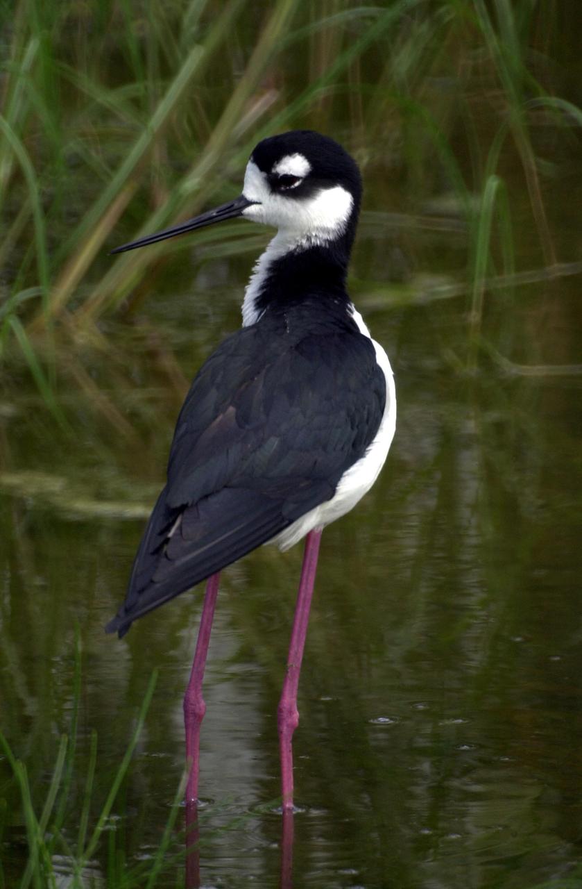
KENNEDY SPACE CENTER, FLA. -- A Black-necked Stilt, distinctive with its black and white coloring and long red legs, wades close to its nest in wetlands near KSC. These stilts inhabit salt marshes and shallow coastal bays in the East
/iss071e414494 (1)~medium.jpg)
iss071e414494 (Aug. 2, 2024) -- The rich red saltwater of Lake Urmia is pictured from the International Space Station as it orbited 260 miles above. Over the past few decades, the lake has shrunk, causing higher salt concentrations in the water, resulting in microscopic organisms turning the water shades of red and orange.
ISS043E184521 (05/10/2015) --- NASA astronaut Terry Virts Expedition 43 Commander on the International Space Station tweeted this Earth observation image of South America with the following comment: "Salar de Uyuni in the #Bolivia desert #SouthAmerica. The world's largest salt flat".
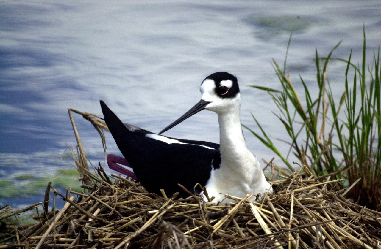
KENNEDY SPACE CENTER, FLA. -- A Black-necked Stilt lies on her nest in wetlands near KSC. Distinctive with its black and white coloring, the species also can be identified by its very long red legs and very thin, long black bill. These stilts inhabit salt marshes and shallow coastal bays in the East
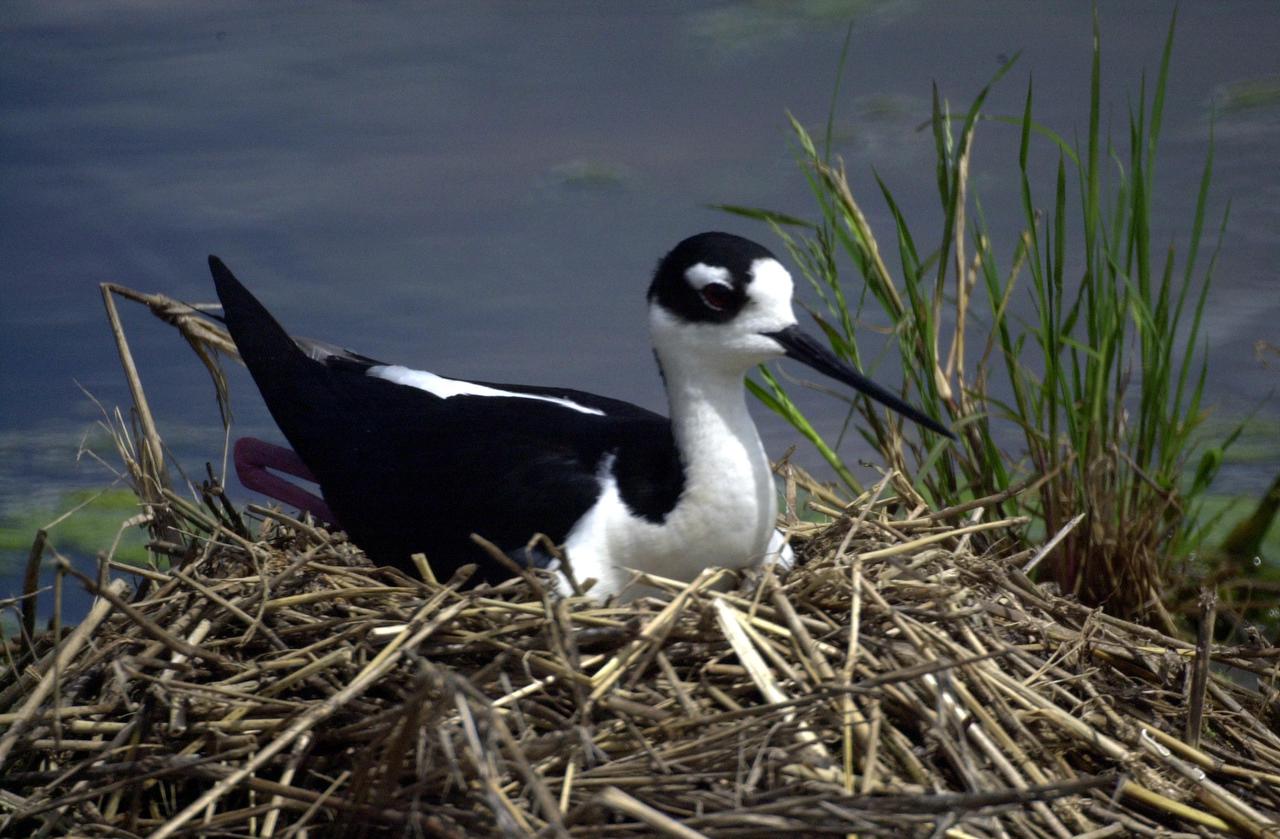
KENNEDY SPACE CENTER, FLA. -- A Black-necked Stilt lies on her nest in wetlands near KSC. Distinctive with its black and white coloring, the species also can be identified by its very long red legs and very thin, long black bill. These stilts inhabit salt marshes and shallow coastal bays in the East
iss072e474246 (Jan. 13, 2025) --- Mar Chiquita Lake, a slowly evaporating salt lake in central Argentina's province of Córdoba that is home to a variety of aquatic birds and other wildlife, is pictured from the International Space Station as it orbited 265 miles above the South American nation.
41G-120-163 (5-13 Oct 1984) --- The long, linear parallel ridges of the Zagros Mountains of southwestern Iran. Dark, round salt domes intrude from deep beneath the earth to produce oil, much of which has yet to be exploited in this area.
iss067e301712 (Aug. 30, 2022) --- Las Salinas del Gualicho, the third largest salt flat in the world and approximately 240 feet below sea level, is pictured from the International Space Station as it orbited 266 miles above Argentina.
Salar de Atacama (Atacama salt flats) in Chile's Atacama Desert receives 2 mm rain per year. Its attraction are the brines 40 m below ground. They are pumped to the surface into large evaporation pans. After the water has vanished, a yellowish greasy solution is left behind that contains lithium. In fact, Salar de Atacama produces 27% of the world's annual supply. Mining lithium here is less expensive to produce than from neighboring Salar de Uyuni, which is estimated to have half of the lithium reserves in the world. The image was acquired August 21, 2017, covers an area of 22.5 by 27.8 km, and is located at 23.5 degrees south, 68.3 degrees west. https://photojournal.jpl.nasa.gov/catalog/PIA23420
Technicians from NASA Jet Propulsion Laboratory in Pasadena, Calif., install thermal blankets on the Aquarius instrument at Brazil National Institute for Space Research.
Gullies are common on steep slopes of many impact craters on Mars. When gullies were first observed, there was a lot of excitement surrounding them because similar features form on Earth through the action of liquid water. However, liquid water is currently unstable on the surface of Mars. Long-term observations have prompted many scientists to question a liquid water origin for the gullies, and alternative ideas have been suggested. These include flows of salt-rich (briny) water, as the salt would allow water to be liquid under lower temperatures than those for pure water. Also "dry" processes, which do not require the action of liquid water at all. Monitoring of gullies by HiRISE could help scientists better understand the conditions where the gullies are active, and in doing so, help understand how they form. https://photojournal.jpl.nasa.gov/catalog/PIA23850
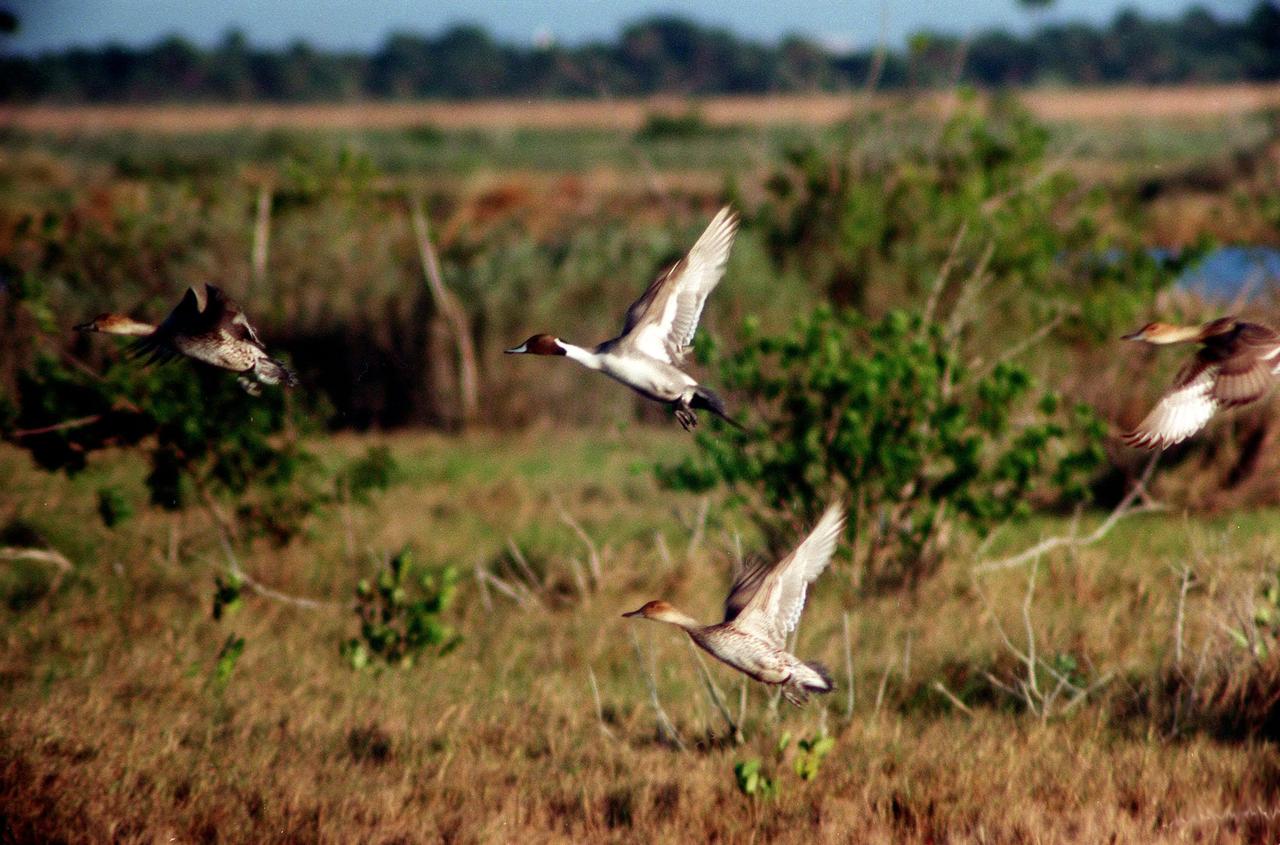
KENNEDY SPACE CENTER, FLA. -- Ducks take flight across the marshes of the Merritt Island National Wildlife Refuge at Kennedy Space Center. The duck at top-center is a pintail, which can be found in marshes, prairie ponds and tundra, and salt marshes in winter. They range from Alaska and Greenland south to Central America and the West Indies. The open waters of the Wildlife Refuge provide wintering areas for 23 species of migratory waterfowl as well as a year-round home for great blue herons, great egrets, wood storks, cormorants, brown pelicans and other species of marsh and shore birds. The refuge comprises 92,000 acres, ranging from fresh-water impoundments, salt-water estuaries and brackish marshes to hardwood hammocks and pine flatwoods