
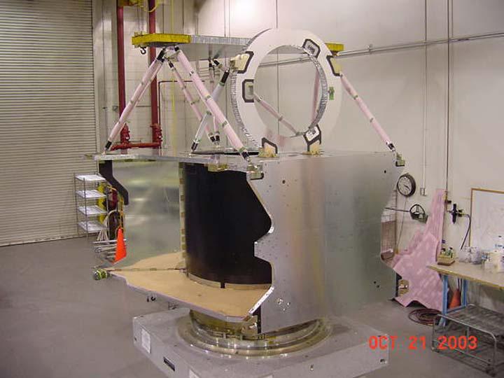
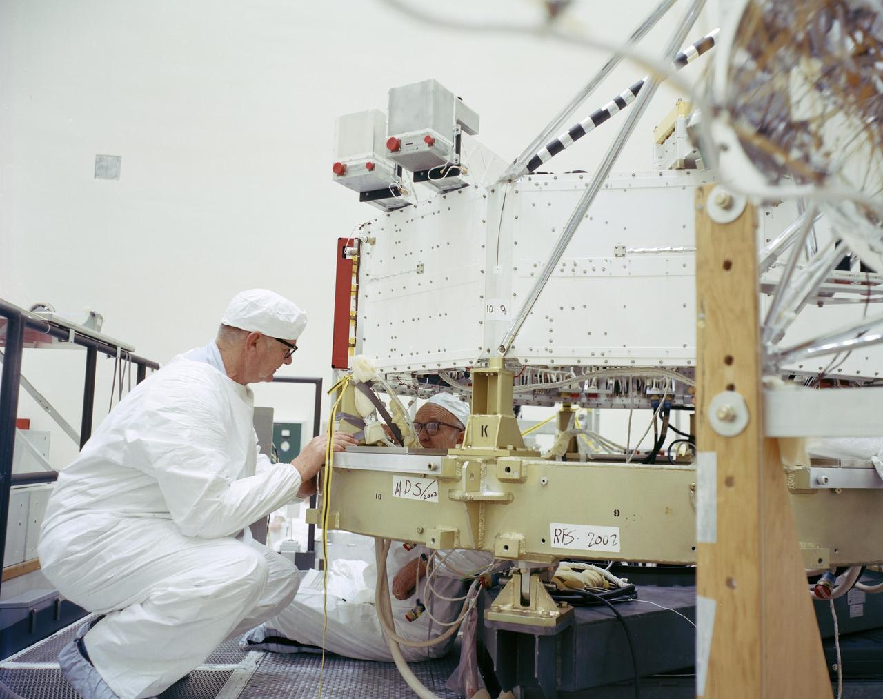
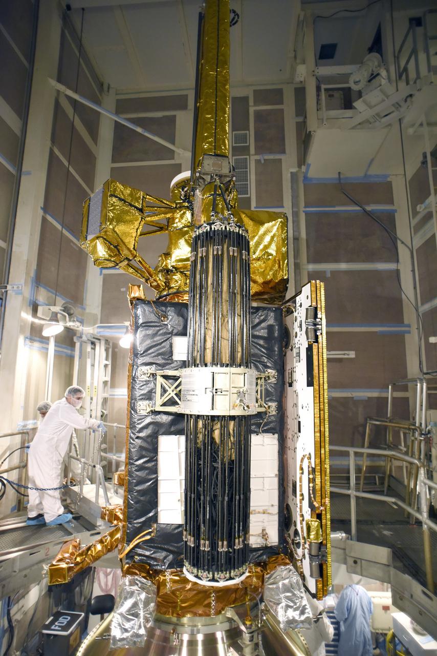
This illustration shows the core structure with ion propulsion system installed aboard NASA Dawn spacecraft.
NASA Mars Atmosphere and Volatile EvolutioN MAVEN spacecraft is scheduled to launch in November 2013 and will be the first mission devoted to understanding the Martian upper atmosphere.
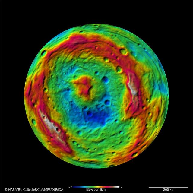
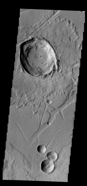
The terrain model of Vesta southern hemisphere shows a big circular structure, its rim rising above the interior of the structure. This false-color map of the giant asteroid Vesta is from the framing camera aboard NASA Dawn spacecraft.
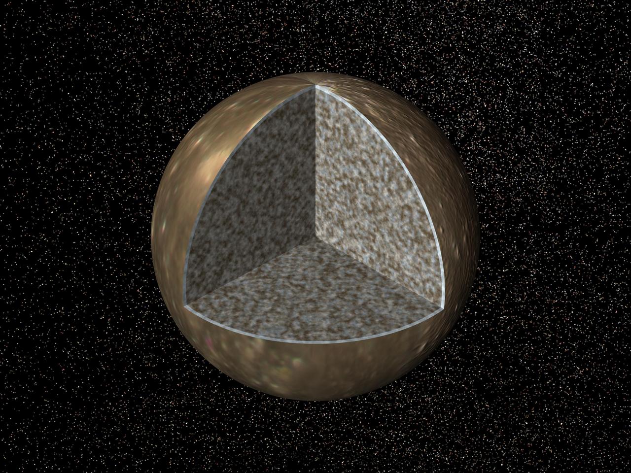
Cutaway view of the possible internal structure of Callisto. The surface of the satellite is a mosaic of images obtained in 1979 by NASA Voyager spacecraft.
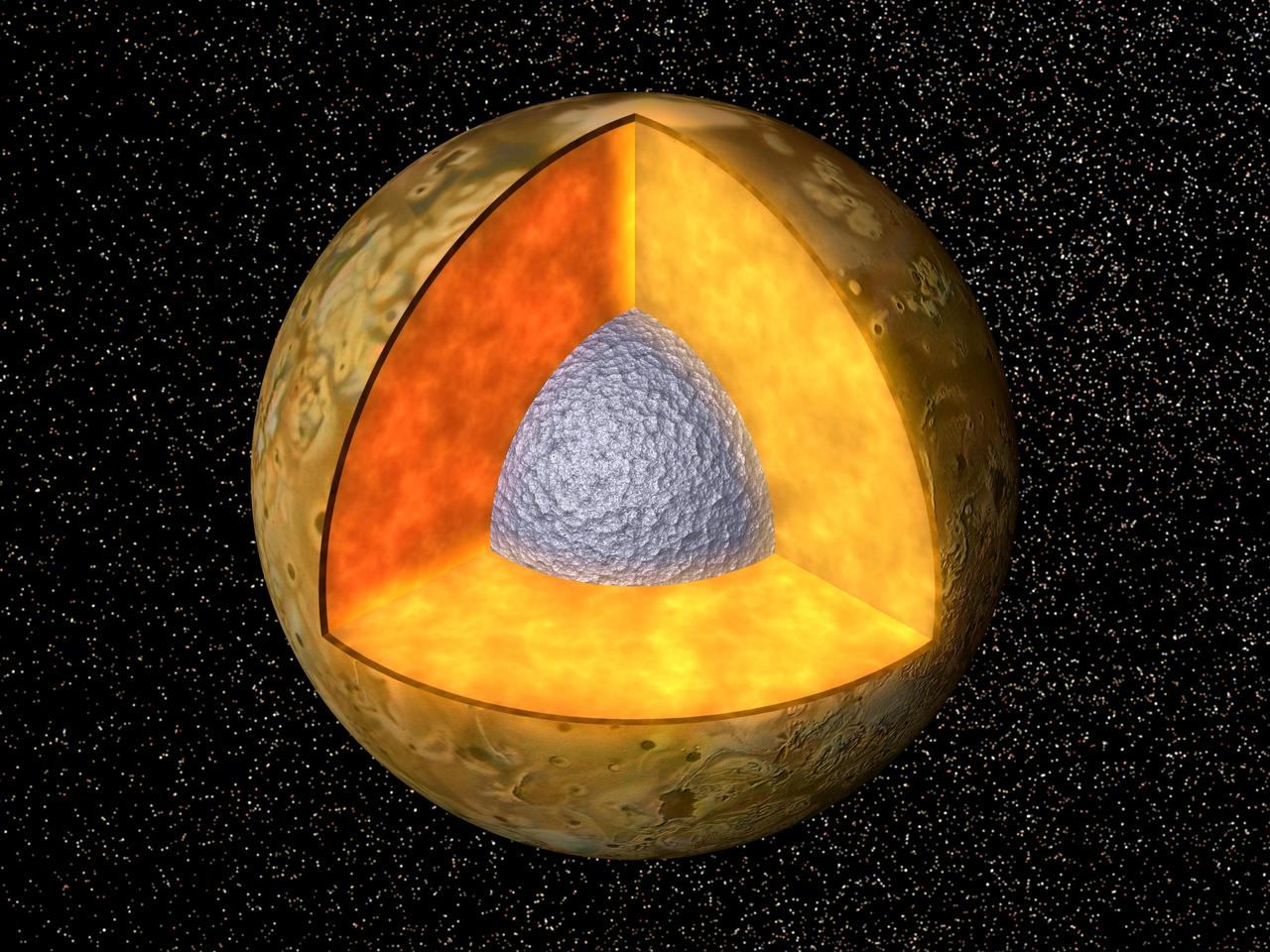
Cutaway view of the possible internal structure of Io. The surface of the satellite is a mosaic of images obtained in 1979 by NASA Voyager spacecraft.
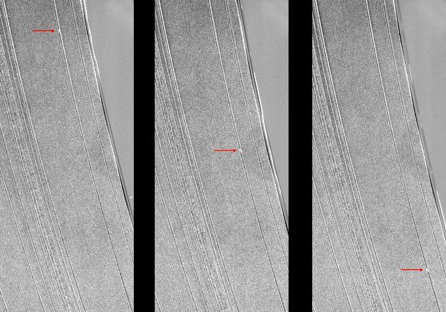
These three images from NASA Cassini spacecraft show a propeller-shaped structure created by an unseen moon in Saturn A ring.
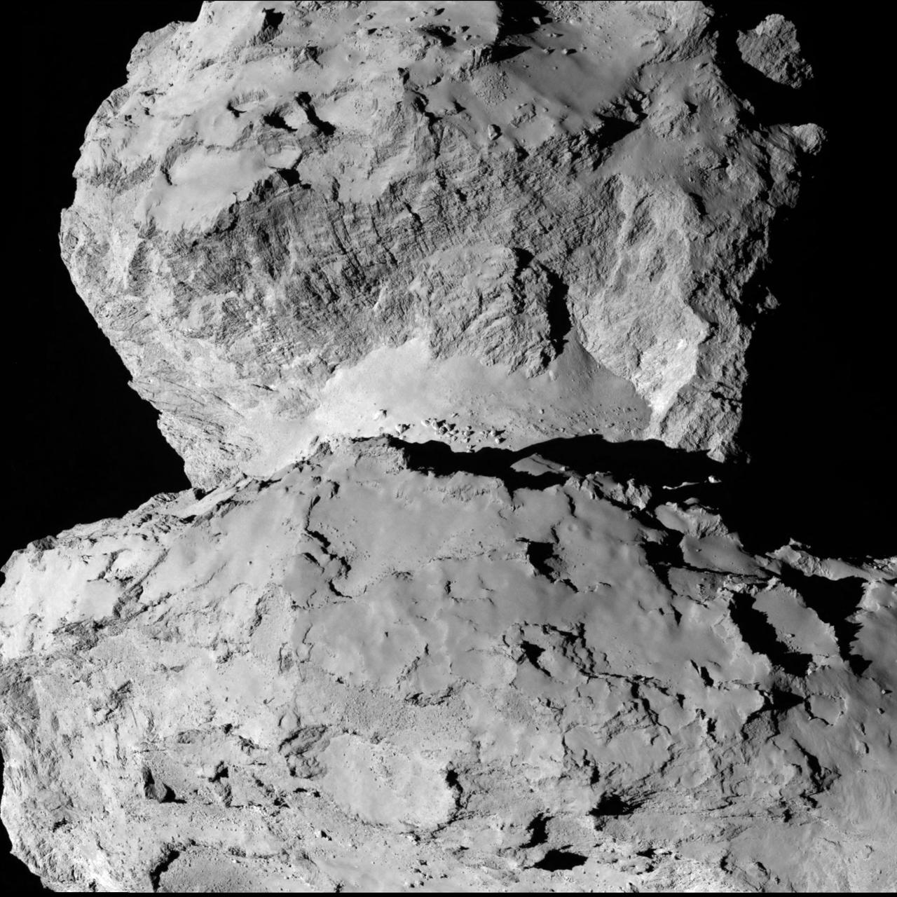
This image from ESA Rosetta spacecraft is of 67P/Churyumov-Gerasimenko shows the diversity of surface structures on the comet nucleus.
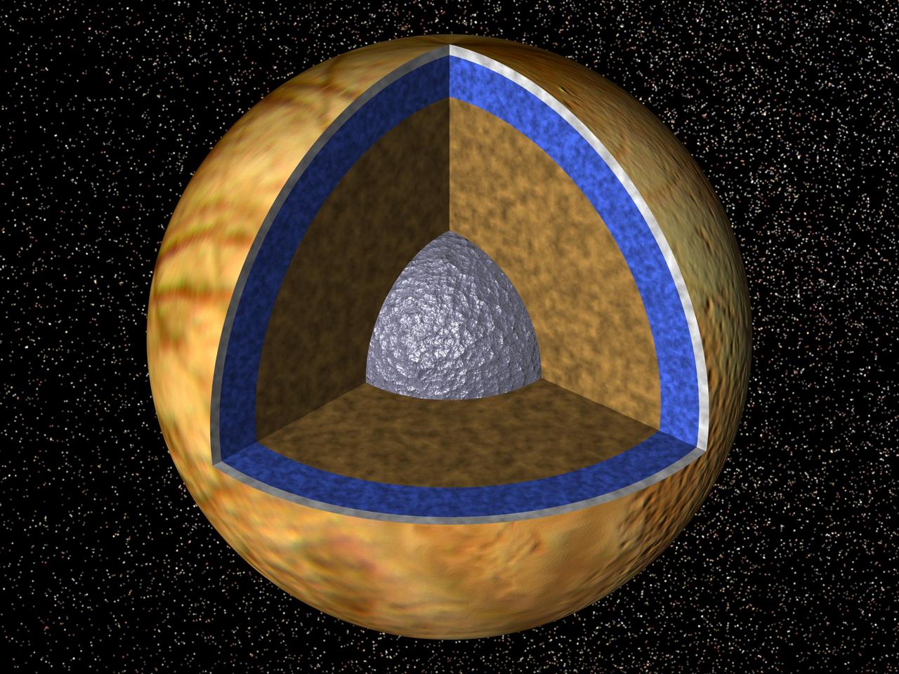
Cutaway view of the possible internal structure of Europa. The surface of the satellite is a mosaic of images obtained in 1979 by NASA Voyager spacecraft.
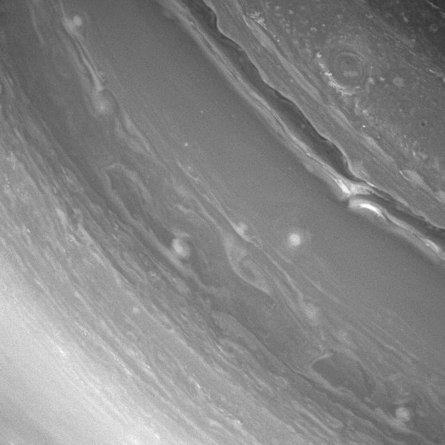
NASA Cassini spacecraft captures Saturn richly dynamic atmosphere rewards viewers with unique and fascinating structures with every new observation.
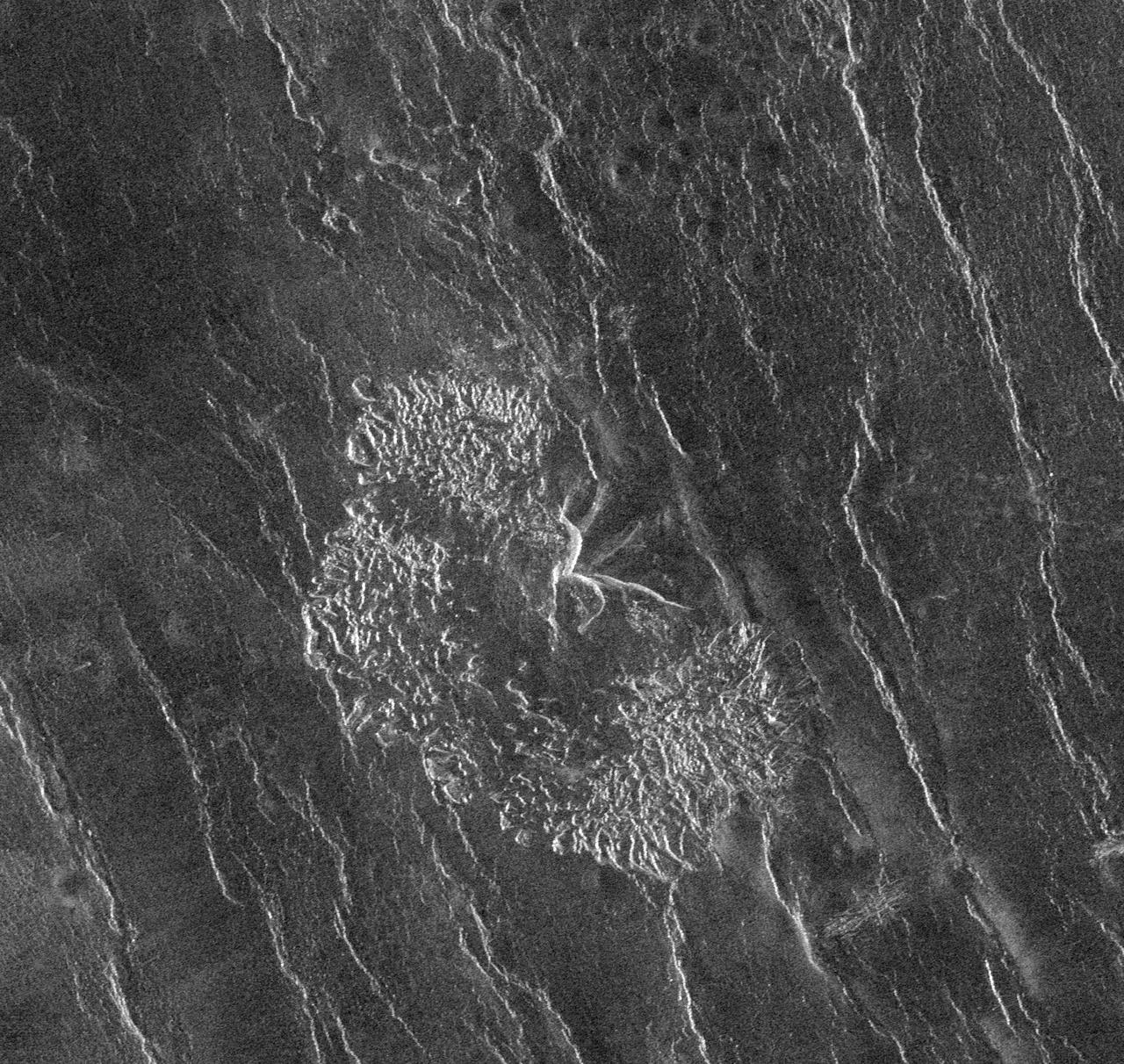
NASA Magellan spacecraft has observed remnant landslide deposits apparently resulting from the collapse of volcanic structures. http://photojournal.jpl.nasa.gov/catalog/PIA00263
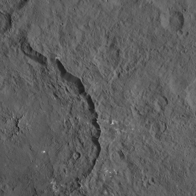
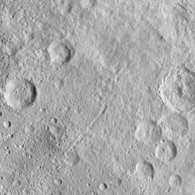
Dantu crater on Ceres, seen here at left, reveals structures hinting at tectonic processes that formed the dwarf planet's surface. Linear structures are spread over the crater floor. Outside the crater's rim, the occurrence of linear structures continues the in form of scarps (linear, cliff-like slopes) and ridges. Dantu's diameter is 78 miles (125 kilometers). The image was taken by NASA's Dawn spacecraft on Oct. 3, 2015, from an altitude of 915 miles (1,470 kilometers). It has a resolution of 450 feet (140 meters) per pixel. The image is located at 31 degrees north latitude, 149 degrees east longitude. http://photojournal.jpl.nasa.gov/catalog/PIA20122
In this image, NASA Cassini spacecraft has captured some of the structure of the tenuous D ring, appearing here as light/dark banding in the upper-right of the image.
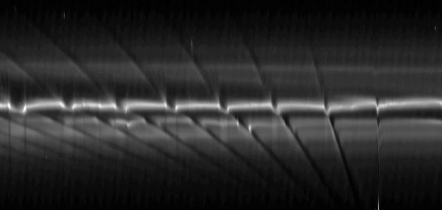
In this image from NASA Cassini spacecraft, the spiral structures in the D ring are on display, although it is so thin as to be barely noticeable compared to the rest of the ring system.
This contrast-enhanced view shows a faint spoke in Saturn B ring. These ghostly radial structures were imaged by the Voyager spacecraft in the 1980s
The structure of NASA Mars Reconnaissance Orbiter spacecraft is constructed from composite panels of carbon layers over aluminum honeycomb, lightweight yet strong.

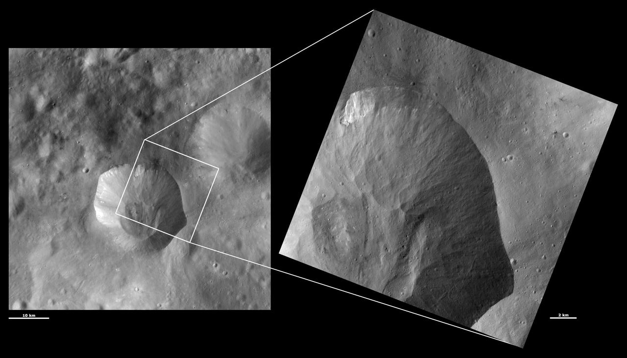
This image from NASA Dawn spacecraft shows the texture of the surface in a part of asteroid Vesta southern hemisphere. This region is just north of the main Rheasilvia structure.
The Cassini spacecraft looks toward daybreak on Saturn through the delicate strands of the C ring. Some structure and contrast is visible in the clouds far below
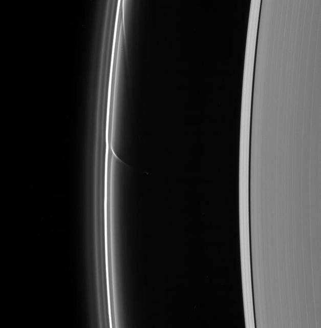
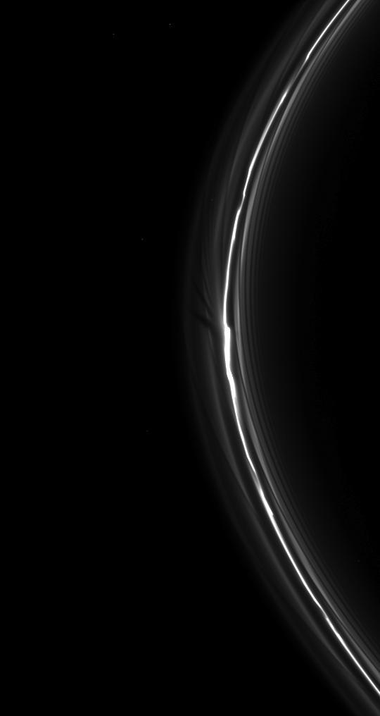
A shepherd moon can do more to define ring structures than just keep the flock of particles in line, as Cassini spacecraft images such as this have shown
The relatively young Canala Crater and its ejecta overlie the tectonic structures of Labeatis Fossae as seen by NASA 2001 Mars Odyssey spacecraft.

Images from NASA Cassini spacecraft using three different filters reveal cloud structures and movements at different depths in the atmosphere around Jupiter south pole.
The Cassini spacecraft looks closely at the outer B ring and the Cassini Division, revealing clump-like structures in the outer edge of the B ring.
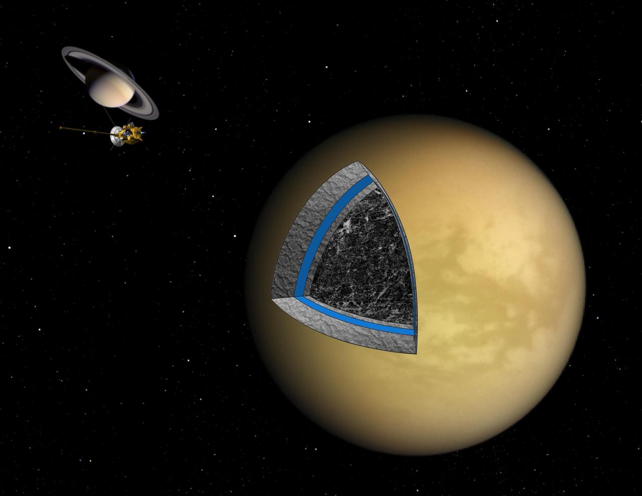
This artist illustration shows the likely interior structure of Saturn moon Titan deduced from gravity field data collected by NASA Cassini spacecraft.
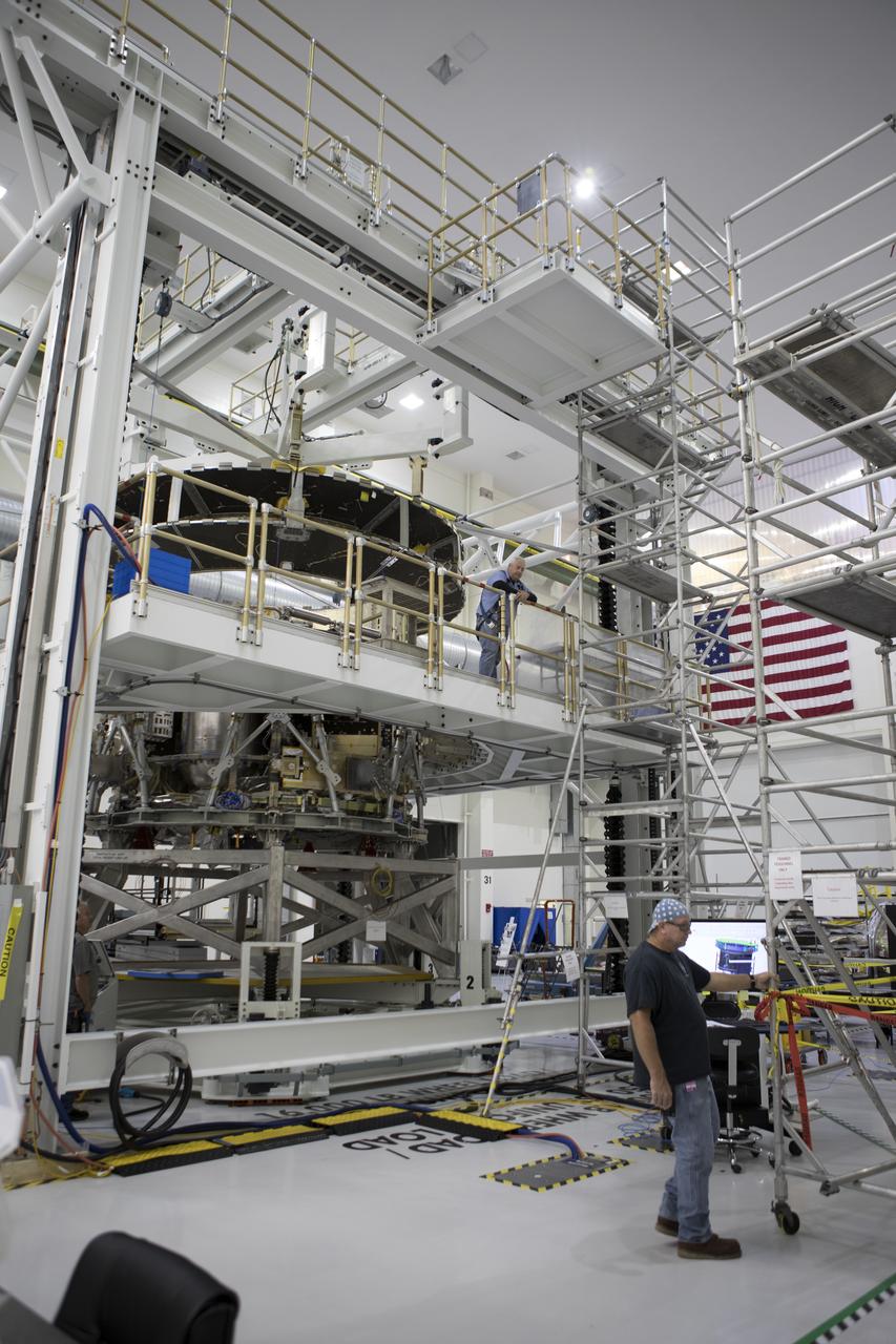
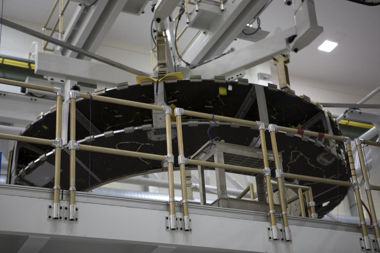
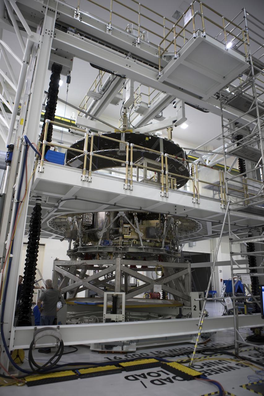
Inside the Integrated Processing Facility at Vandenberg Space Force Base in California, NASA’s Landsat 9 observatory is lowered onto a fixture structure on July 12, 2021. Landsat 9 will launch on a United Launch Alliance Atlas V rocket from Space Launch Complex 3 at Vandenberg in September 2021. The launch is being managed by NASA’s Launch Services Program based at Kennedy Space Center, America’s multiuser spaceport. The Landsat 9 satellite will continue the nearly 50-year legacy of previous Landsat missions. It will monitor key natural and economic resources from orbit. Landsat 9 is managed by the agency’s Goddard Space Flight Center in Greenbelt, Maryland. The satellite will carry two instruments: the Operational Land Imager 2, which collects images of Earth’s landscapes in visible, near infrared and shortwave infrared light, and the Thermal Infrared Sensor 2, which measures the temperature of land surfaces. Like its predecessors, Landsat 9 is a joint mission between NASA and the U.S. Geological Survey.
Inside the Integrated Processing Facility at Vandenberg Space Force Base in California, NASA’s Landsat 9 observatory is lifted for its move to a fixture structure on July 12, 2021. Landsat 9 will launch on a United Launch Alliance Atlas V rocket from Space Launch Complex 3 at Vandenberg in September 2021. The launch is being managed by NASA’s Launch Services Program based at Kennedy Space Center, America’s multiuser spaceport. The Landsat 9 satellite will continue the nearly 50-year legacy of previous Landsat missions. It will monitor key natural and economic resources from orbit. Landsat 9 is managed by the agency’s Goddard Space Flight Center in Greenbelt, Maryland. The satellite will carry two instruments: the Operational Land Imager 2, which collects images of Earth’s landscapes in visible, near infrared and shortwave infrared light, and the Thermal Infrared Sensor 2, which measures the temperature of land surfaces. Like its predecessors, Landsat 9 is a joint mission between NASA and the U.S. Geological Survey.
Inside the Integrated Processing Facility at Vandenberg Space Force Base in California, technicians attach a crane to NASA’s Landsat 9 observatory for its lift to a fixture structure on July 12, 2021. Landsat 9 will launch on a United Launch Alliance Atlas V rocket from Space Launch Complex 3 at Vandenberg in September 2021. The launch is being managed by NASA’s Launch Services Program based at Kennedy Space Center, America’s multiuser spaceport. The Landsat 9 satellite will continue the nearly 50-year legacy of previous Landsat missions. It will monitor key natural and economic resources from orbit. Landsat 9 is managed by the agency’s Goddard Space Flight Center in Greenbelt, Maryland. The satellite will carry two instruments: the Operational Land Imager 2, which collects images of Earth’s landscapes in visible, near infrared and shortwave infrared light, and the Thermal Infrared Sensor 2, which measures the temperature of land surfaces. Like its predecessors, Landsat 9 is a joint mission between NASA and the U.S. Geological Survey.
Inside the Integrated Processing Facility at Vandenberg Space Force Base in California, technicians prepare NASA’s Landsat 9 observatory for its lift to a fixture structure on July 12, 2021. Landsat 9 will launch on a United Launch Alliance Atlas V rocket from Space Launch Complex 3 at Vandenberg in September 2021. The launch is being managed by NASA’s Launch Services Program based at Kennedy Space Center, America’s multiuser spaceport. The Landsat 9 satellite will continue the nearly 50-year legacy of previous Landsat missions. It will monitor key natural and economic resources from orbit. Landsat 9 is managed by the agency’s Goddard Space Flight Center in Greenbelt, Maryland. The satellite will carry two instruments: the Operational Land Imager 2, which collects images of Earth’s landscapes in visible, near infrared and shortwave infrared light, and the Thermal Infrared Sensor 2, which measures the temperature of land surfaces. Like its predecessors, Landsat 9 is a joint mission between NASA and the U.S. Geological Survey.
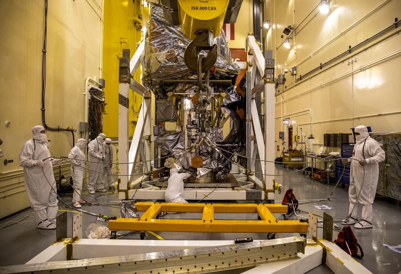
Inside the Integrated Processing Facility at Vandenberg Space Force Base in California, technicians prepare NASA’s Landsat 9 observatory for its lift to a fixture structure on July 12, 2021. Landsat 9 will launch on a United Launch Alliance Atlas V rocket from Space Launch Complex 3 at Vandenberg in September 2021. The launch is being managed by NASA’s Launch Services Program based at Kennedy Space Center, America’s multiuser spaceport. The Landsat 9 satellite will continue the nearly 50-year legacy of previous Landsat missions. It will monitor key natural and economic resources from orbit. Landsat 9 is managed by the agency’s Goddard Space Flight Center in Greenbelt, Maryland. The satellite will carry two instruments: the Operational Land Imager 2, which collects images of Earth’s landscapes in visible, near infrared and shortwave infrared light, and the Thermal Infrared Sensor 2, which measures the temperature of land surfaces. Like its predecessors, Landsat 9 is a joint mission between NASA and the U.S. Geological Survey.
This archival photo shows engineers at NASA's Jet Propulsion Laboratory working on the 10-sided central structure, or "bus," of the Voyager 2 spacecraft on February 24,1977. https://photojournal.jpl.nasa.gov/catalog/PIA21478
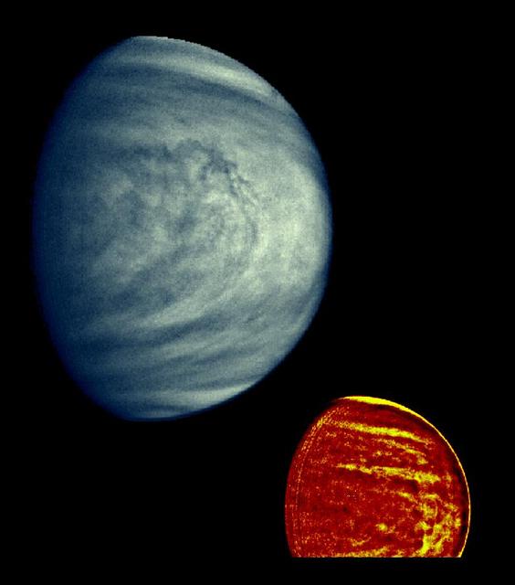
These two images of Venus from NASA Galileo spacecraft show the global structure of cloud patterns at two different depths in the upper cloud layers. http://photojournal.jpl.nasa.gov/catalog/PIA00073
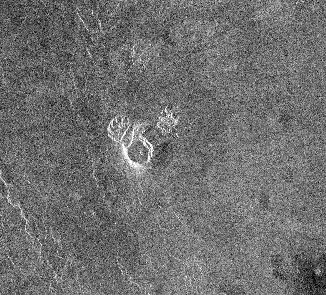
NASA Magellan spacecraft observed remnant landslide deposits apparently resulting from the collapse of volcanic structures. This radar image is centered in the southwestern Navka Region of Venus. http://photojournal.jpl.nasa.gov/catalog/PIA00262
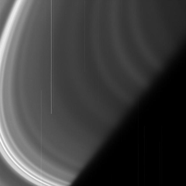
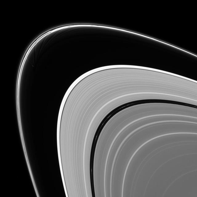
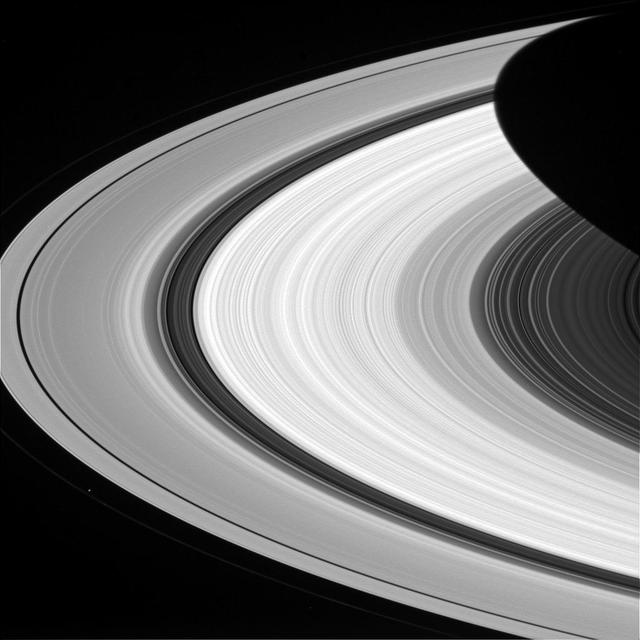
This view from NASA's Cassini spacecraft showcases some of the amazingly detailed structure of Saturn's rings. The rings are made up of many smaller ringlets that blur together when seen from a distance. But when imaged up close, the rings' structures display quite a bit of variation. Ring scientists are debating the nature of these features -- whether they have always appeared this way or if their appearance has evolved over time. This view looks toward the sunlit side of the rings from about 4 degrees above the ring plane. The image was taken in visible light with the Cassini spacecraft wide-angle camera on Sept. 24, 2016. The view was acquired at a distance of approximately 283,000 miles (456,000 kilometers) from Saturn and at a Sun-Saturn-spacecraft, or phase, angle of 32 degrees. Image scale is 17 miles (27 kilometers) per pixel. http://photojournal.jpl.nasa.gov/catalog/PIA20506

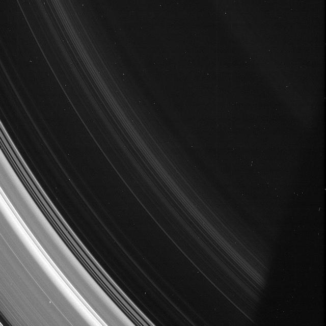
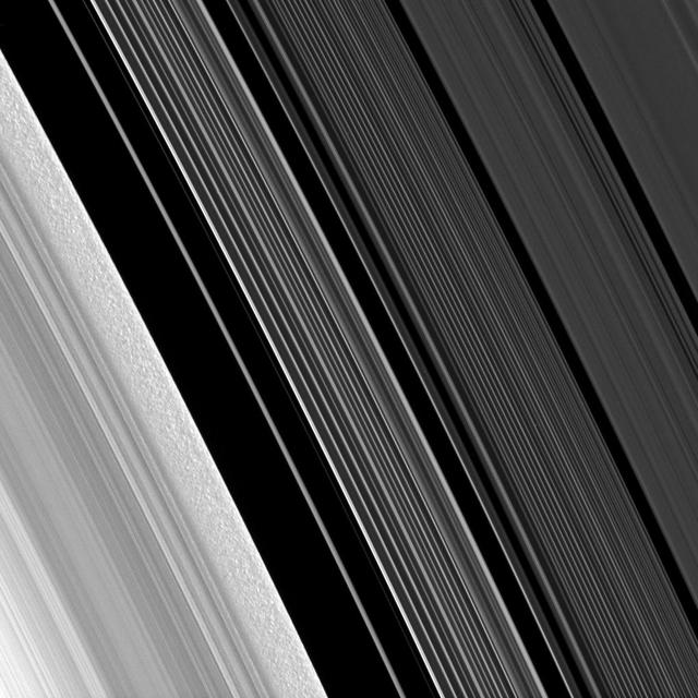
NASA's Cassini spacecraft zoomed in on Saturn's A ring, revealing narrow, detailed structures that get even finer as the cameras' resolution increases. Even at this level of detail, it is still not fine enough to resolve the individual particles that make up the ring. High-resolution images like this help scientists map the fine structure of Saturn's rings. Features less than a half a mile (one kilometer) in size are resolvable here. But the particles in the A ring typically range in size from several meters across down to centimeters, making them still far too small to see individually here. This view looks toward the sunlit side of the rings from about 38 degrees above the ring plane. The image was taken in visible light with the Cassini spacecraft narrow-angle camera on Jan. 9, 2017. The view was obtained at a distance of approximately 70,000 miles (113,000 kilometers) from Saturn and at a Sun-Saturn-spacecraft, or phase, angle of 11 degrees. Image scale is 2,300 feet (690 meters) per pixel. http://photojournal.jpl.nasa.gov/catalog/PIA20526
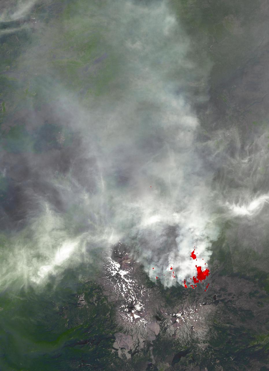
This image, acquired by NASA Terra spacecraft, is of the Pole Creek fire southwest of Sisters, Ore., which had grown to 24,000 acres as of Sept. 20, 2012. No structures have been destroyed, and the fire is mostly confined to the national forest.
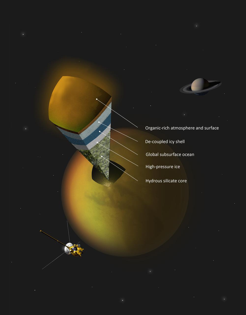
This artist concept shows a possible scenario for the internal structure of Titan, as suggested by data from NASA Cassini spacecraft. Scientists have been trying to determine what is under Titan organic-rich atmosphere and icy crust.
The A and F rings are alive with moving structures in this Cassini spacecraft view. Graceful drapes of ring material created by Prometheus are seen sliding by at left, while clumpy ringlets slip through the Encke Gap
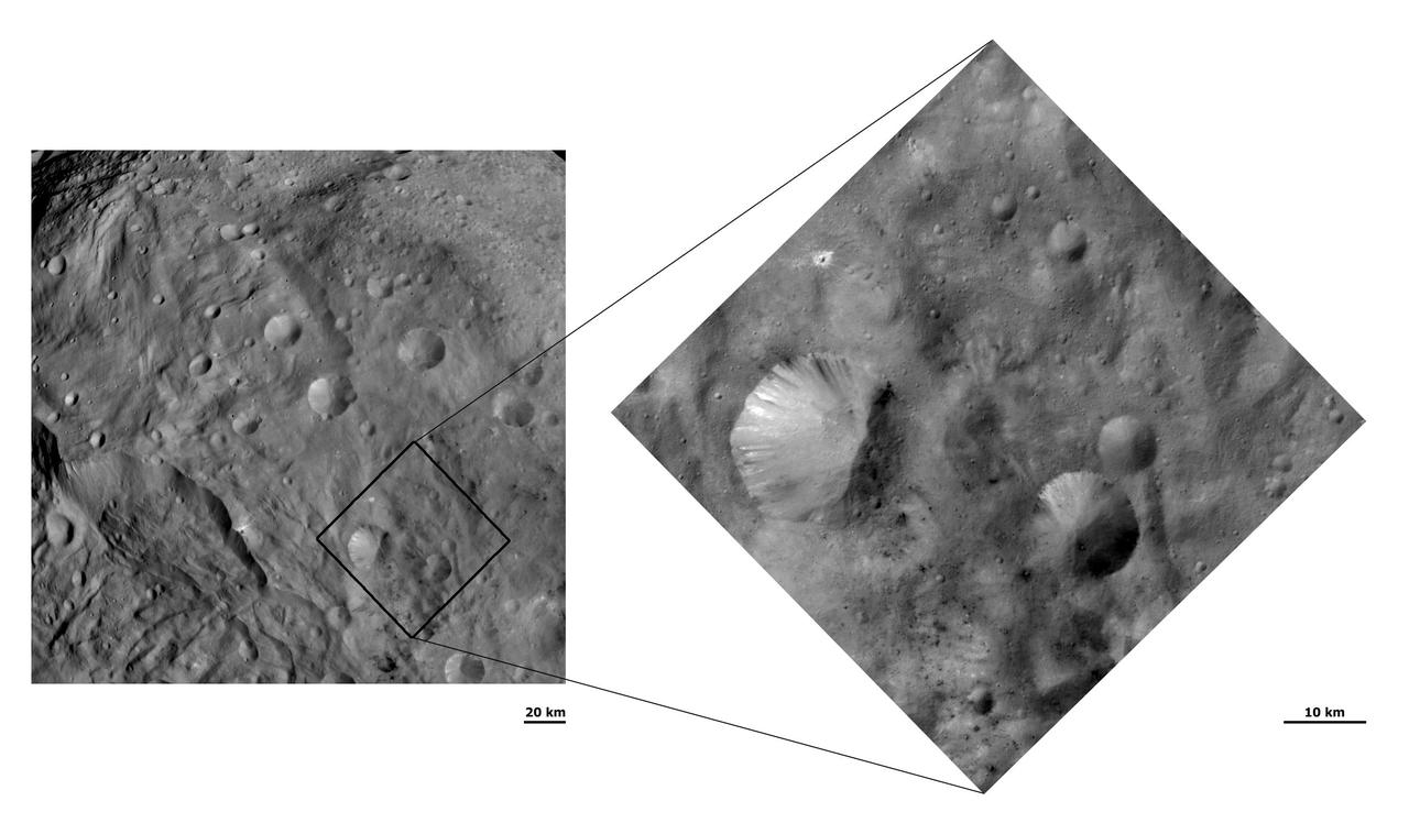
This image from NASA Dawn spacecraft shows craters with both sharp and smooth crater rims in asteroid Vesta southern hemisphere. Detailed structure is seen more readily in the the image with a smaller view at right.
A propeller-shaped structure created by an unseen moon is brightly illuminated on the sunlit side of Saturn rings in this image obtained by NASA Cassini spacecraft. The moon, which is too small to be seen, is marked with a red arrow.
The Cassini spacecraft continues to profile the haze structure and opacity in Saturn upper atmosphere with images like this, which captures Rigel, a star in Orion whose brightness is well-known, as it passes behind the planet
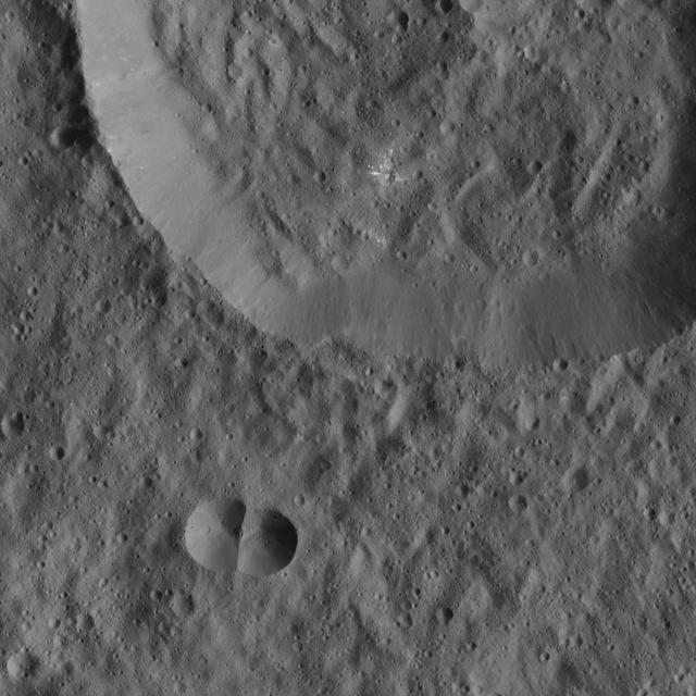
This image from NASA Dawn spacecraft of Ceres shows a small, double-impact crater at bottom near a larger crater. The larger structure has a crater floor with roughly the same crater density.
Forever changing, the F ring takes on a ladder-like appearance in this recent image from NASA Cassini spacecraft. Scientists believe that interactions between the F ring and the moons Prometheus and Pandora cause the dynamic structure of the ring.
These images from NASA Dawn spacecraft are located in asteroid Vesta Numisia quadrangle, in Vesta southern hemisphere. fine-scale structure of the slumping-related features on Drusilla sloping sides.

NASA Galileo spacecraft acquired this global mosaic right during Galileo third orbit on Nov. 4, 1996. The lighter bluish area in the upper latitudes is the Asgard multi-ring structure with crater Burr to the north and Tornasuk to the east.

This image obtained by the framing camera on NASA Dawn spacecraft shows the south pole of the giant asteroid Vesta. Scientists are discussing whether the circular structure that covers most of this image originated by a collision with another asteroid.
NASA Dawn spacecraft obtained this image of a central mound in a large structure at the south pole of asteroid Vesta with its framing camera on August 12, 2011. This image was taken through the camera clear filter.
This image from NASA Dawn spacecraft shows Cornelia crater on asteroid Vesta with a sharp, fresh rim. Cornelia crater has a spectacular internal structure, which consists of bright and dark material.
This image of the coma of comet 67P/Churyumov-Gerasimenko, seen with ESAS OSIRIS onboard the Rosetta spacecraft, shows the hazy circular structure to the right and center of the coma is an artifact due to overexposure of the nucleus.
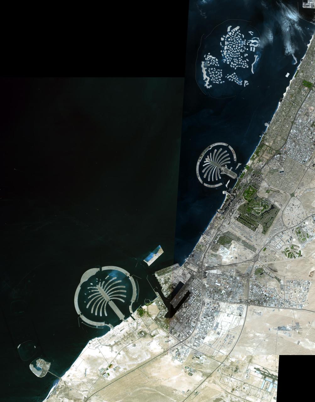
The Palm Islands are artificial islands in Dubai, United Arab emirates on which major commercial and residential structures are being built. NASA Terra spacecraft acquired this image on November 17 and December 10, 2008.
This image from NASA Dawn spacecraft show a slightly curved chain of small craters in the bottom half of the image. This chain is located on the floor of asteroid Vesta large south-polar impact structure, Rheasilvia.

The complex structure and beauty of polar clouds are highlighted by these images acquired by NASA Terra spacecraft on April 23, 2003. These clouds occur at multiple altitudes and exhibit a noticeable cyclonic circulation over the Southern Indian Ocean,
This image of comet 67P/Churyumov-Gerasimenko was obtained on October 30, 2014 by the OSIRIS scientific imaging system on the Rosetta spacecraft. The saturation of the image allows the viewer to see some surface structures on dark side of the comet.
Bright clumps of ring material and a fan-like structure appear near the core of Saturn tenuous F ring in this mosaic of images from NASA Cassini spacecraft. Such features suggest the existence of additional objects in the F ring.

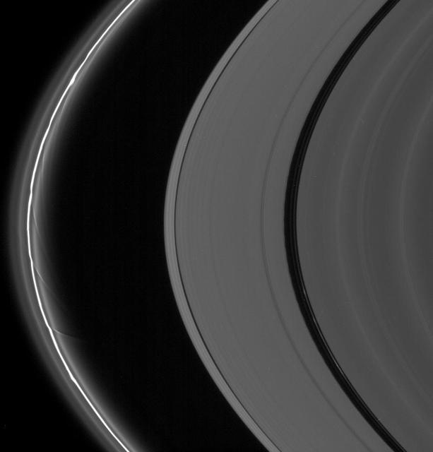
NASA Cassini spacecraft looks between Saturn A and B rings to spy structure in the Cassini Division. The Cassini Division, occupying the middle and left of the image, contains five dim bands of ring material, but not all of the division is shown here.
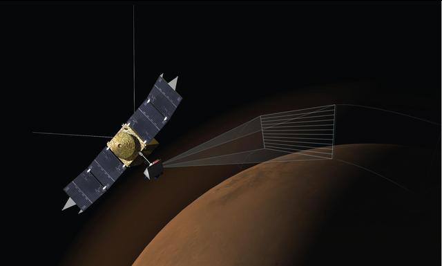
This artist concept depicts the Imaging Ultraviolet Spectrograph IUVS on NASA MAVEN spacecraft scanning the upper atmosphere of Mars. IUVS uses limb scans to map the chemical makeup and vertical structure across Mars upper atmosphere.
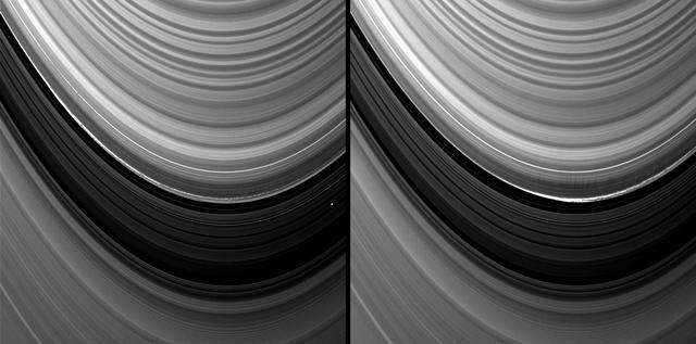
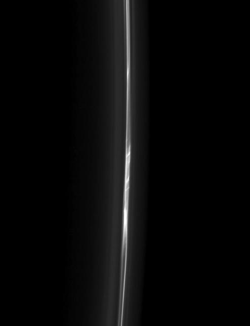
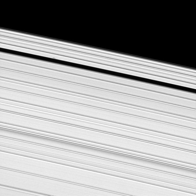
Vertical structures in the variable outer edge of Saturn B ring cast shadows in these two images captured by NASA Cassini spacecraft shortly after the planet August 2009 northern vernal equinox.

This image from NASA Dawn spacecraft shows the rim of Occator crater, just east of the area containing the brightest spots on Ceres. The crater rim has collapsed, leaving structures geologists refer to as terraces.
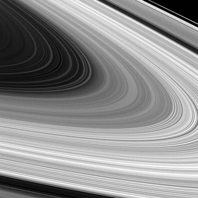
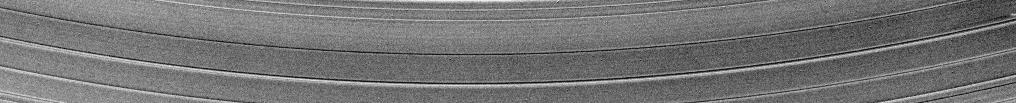
Saturn B ring is spread out in all its glory in this image from NASAS Cassini spacecraft. Scientists are trying to better understand the origin and nature of the various structures seen in the B ring.
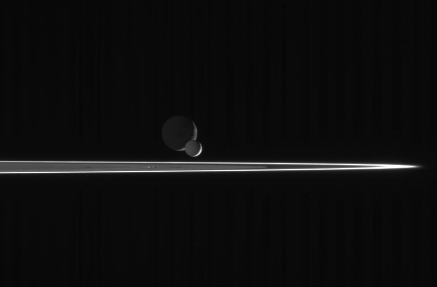
s our robotic emissary to Saturn, the Cassini spacecraft is privileged to behold such fantastic sights as this pairing of two moons beyond the rings. The bright, narrow F ring is the outermost ring structure seen here
A propeller-shaped structure, created by an unseen moon, can be seen in Saturn A ring and looks like a small, dark line interrupting the bright surrounding ring material in the upper left of this image taken by NASA Cassini spacecraft.
This image is part of a set of images obtained by NASA Cassini spacecraft showing a propeller-shaped structure created by a hidden, embedded moon moving through one of Saturn rings. An animation is available at the Photojournal.
This mosaic of images from NASA Cassini spacecraft depicts fan-like structures in Saturn tenuous F ring. Bright features are also visible near the core of the ring. Such features suggest the existence of additional objects in the F ring.
NASA Cassini spacecraft spies a fan in Saturn tenuous F ring. This fan-like structure appears as dark lines spreading outward from the left of the bright clump of ring material near the center of the image.
This view of Callisto Asgard multi-ring structure was taken by NASA Galileo spacecraft. The large bright/white area is the palimpsest or center of Asgard. The smaller bright area is the crater Tornasuk.
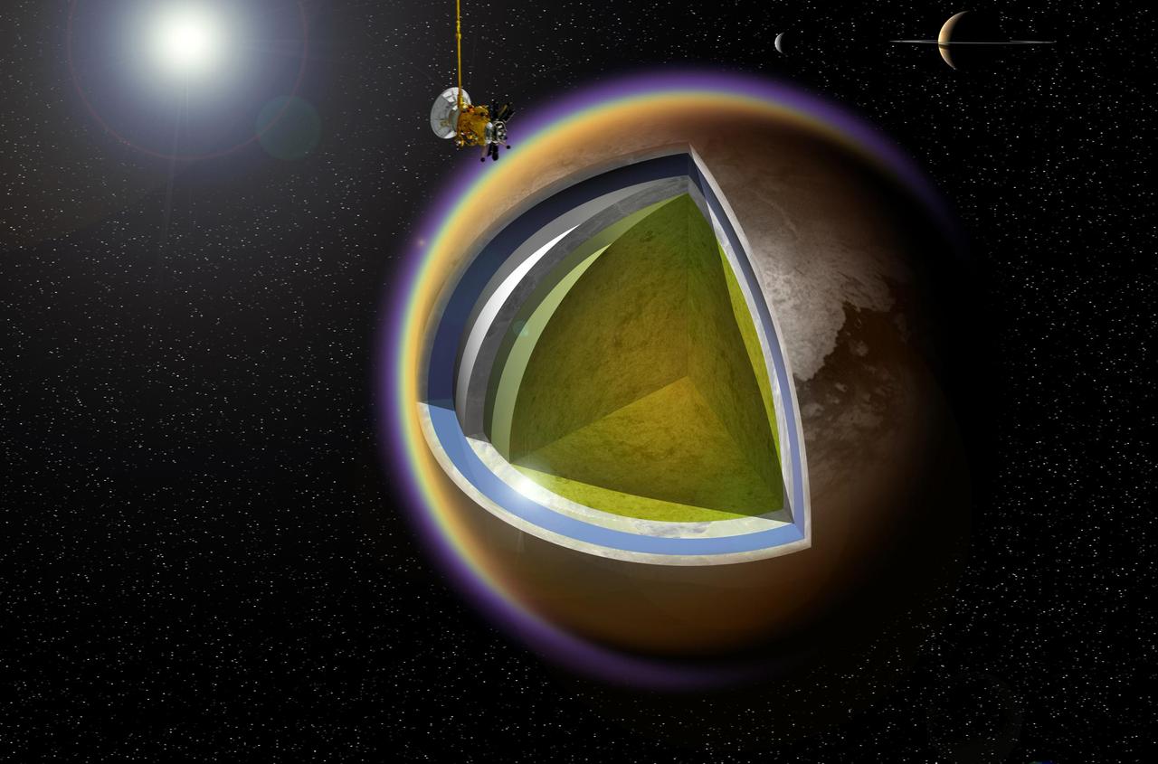
This artist concept shows a possible model of Titan internal structure that incorporates data from NASA Cassini spacecraft. A model of Cassini is shown making a targeted flyby over Titan cloudtops; Saturn and Enceladus appear at upper right.
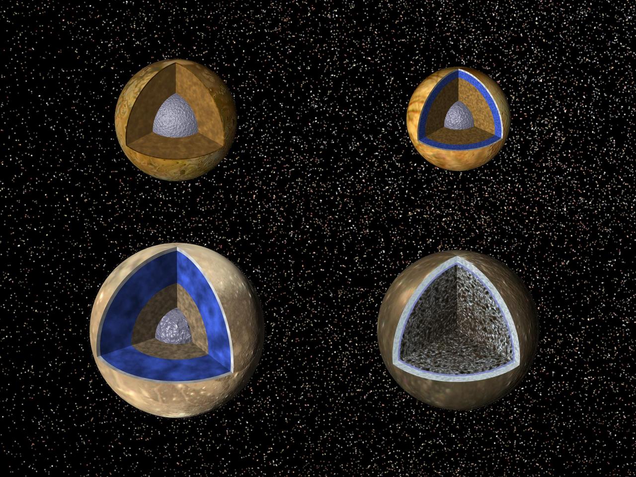
Cutaway views of the possible internal structures of the Galilean satellites. Ganymede at lower left, Callisto at lower right, Io on upper left, and Europa on upper right in a combined biew from NASA Galileo and Voyager spacecraft.

Several structures in Saturn A ring are exposed near the Encke Gap in this image captured by NASA Cassini spacecraft. A peculiar kink can be seen in one particularly bright ringlet at the bottom right.
A propeller-shaped structure created by an unseen moon appears dark in this image obtained by NASA Cassini spacecraft of the unilluminated side of Saturn rings. The propeller is marked with a red arrow in the top left.
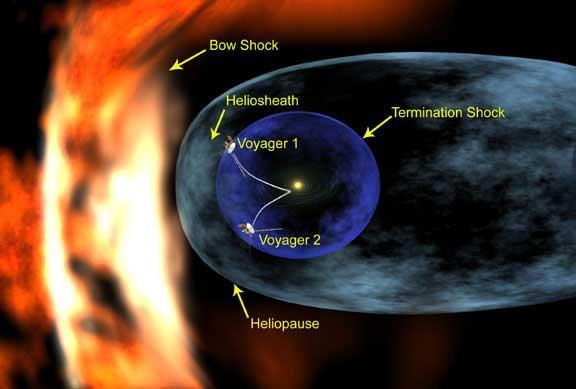
An artist's concept illustrates the positions of the Voyager spacecraft in relation to structures formed around our Sun by the solar wind. Also illustrated is the termination shock, a violent region the spacecraft must pass through before reaching the outer limits of the solar system. At the termination shock, the supersonic solar wind abruptly slows from an average speed of 400 kilometers per second to less than 100 kilometer per second (900,000 to less than 225,000 miles per hour). Beyond the termination shock is the solar system's final frontier, the heliosheath, a vast region where the turbulent and hot solar wind is compressed as it presses outward against the interstellar wind that is beyond the heliopause. A bow shock likely forms as the interstellar wind approaches and is deflected around the heliosphere, forcing it into a teardrop-shaped structure with a long, comet-like tail. The exact location of the termination shock is unknown, and it originally was thought to be closer to the Sun than Voyager 1 currently is. As Voyager 1 cruised ever farther from the Sun, it confirmed that all the planets are inside an immense bubble blown by the solar wind and the termination shock was much more distant. http://photojournal.jpl.nasa.gov/catalog/PIA04927
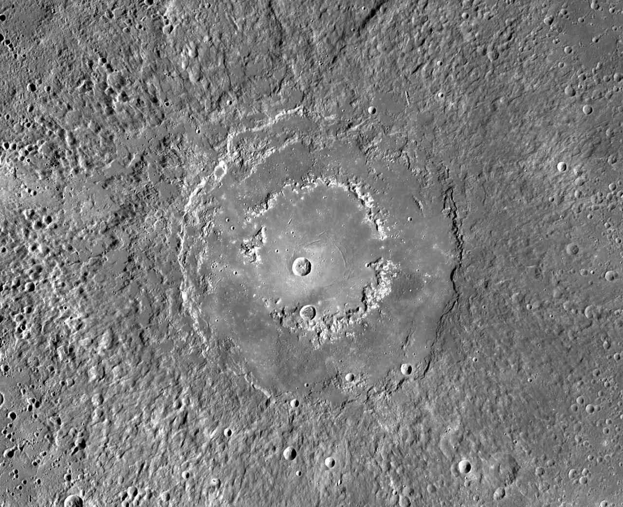
This MDIS mosaic from NASA MESSENGER spacecraft provides a detailed view of the features and structures associated with the peak-ring basin Raditladi. Raditladi, first imaged during MESSENGER's first Mercury flyby and named in April 2008, continues to be an intriguing region of study, with its well-preserved features, relatively young age, exterior impact melt ponds, hollows-covered peak ring, and concentric troughs on its floor. Instrument: Mercury Dual Imaging System (MDIS) Center Latitude: 27.1° N Center Longitude: 119.2° E Scale: Raditladi has a diameter of 258 kilometers (160 miles) http://photojournal.jpl.nasa.gov/catalog/PIA19409
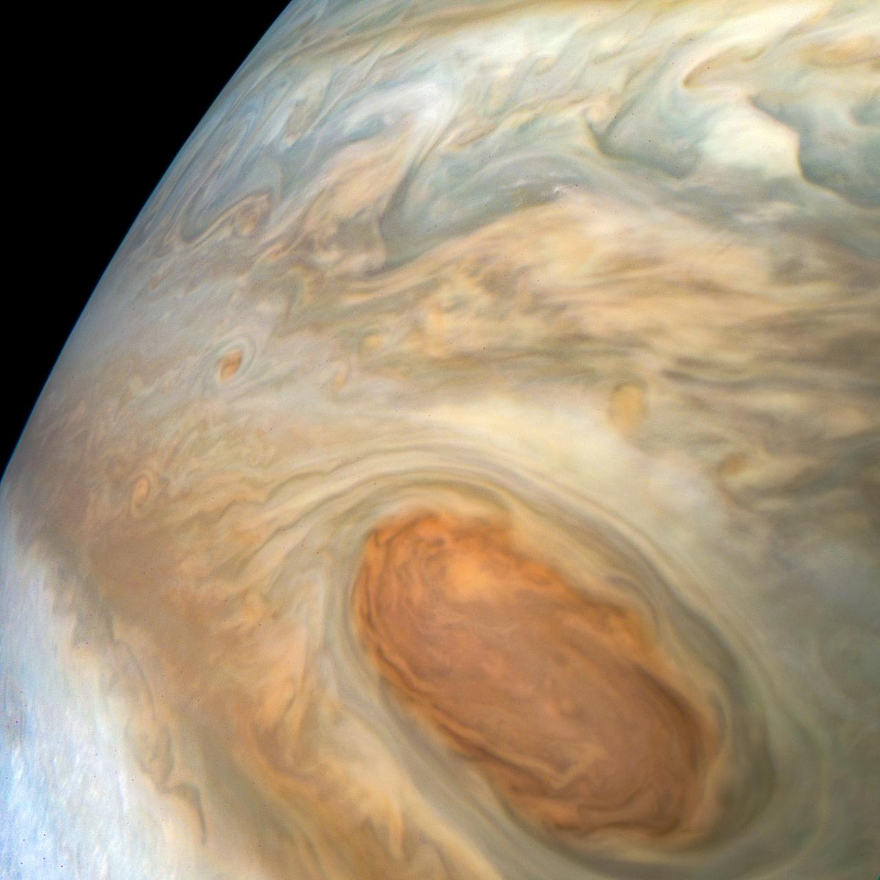
Detailed structure in the clouds of Jupiter's South Equatorial Belt brown barge is visible in this color-enhanced image taken at 10:28 p.m. PDT on July 15, 2018 (1:28 a.m. EDT on July 16), as the spacecraft performed its 14th close flyby of the gas giant planet. Citizen scientist Kevin M. Gill created this image using data from the spacecraft's JunoCam imager. https://photojournal.jpl.nasa.gov/catalog/PIA22941. Enhanced image by Kevin M. Gill (CC-BY) based on images provided courtesy of NASA/JPL-Caltech/SwRI/MSSS
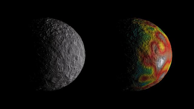
This frame from an animation shows Ceres as seen by NASA's Dawn spacecraft from its high-altitude mapping orbit at 913 miles (1,470 kilometers) above the surface. The colorful map overlaid at right shows variations in Ceres' gravity field measured by Dawn, and gives scientists hints about the dwarf planet's internal structure. Red colors indicate more positive values, corresponding to a stronger gravitational pull than expected, compared to scientists' pre-Dawn model of Ceres' internal structure; blue colors indicate more negative values, corresponding to a weaker gravitational pull. The animation was created by projecting a map of Ceres onto a rotating sphere. The image scale is about 450 feet (140 meters) per pixel. The animations are available at https://photojournal.jpl.nasa.gov/catalog/PIA22083
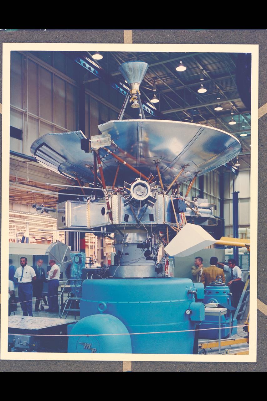
Pioneer F/G spacecraft structural model on shaker

51L-10187 (18 April 1986) --- A 9'7" x 16' segment of Challenger's right wing is unloaded at the Logistics Facility after being off-loaded from the rescue and salvage ship USS Opportune. It was located and recovered by Navy divers from the Opportune about 12 nautical miles northeast of Cape Canaveral in 70 feet of water. Photo credit: NASA

Space Station Freedom option A showing two Soyuz Assured Crew Return Vehicle (ACRV) capsules docked at berthing ports.
![A portion of the central zone of the large impact structure Valhalla on Jupiter's moon Callisto was imaged by the Galileo spacecraft on November 4, 1996. The area shown here is centered at 16 degrees north, 55 degrees west and is about seven miles (11 kilometers) across. This is the highest resolution picture ever taken of Callisto and shows features as small as 200 feet (60 meters) across. The formation of Valhalla occurred early in Callisto's history; however, the central zone shown here is probably younger than Valhalla's surrounding structure. This newly [sic] acquired picture shows some small craters, although they have been softened or modified by downslope movement of debris, revealing bright ice-rich surfaces. In contrast to other areas on Callisto, most of the very smallest craters appear to have been completely obliterated. This image was taken by the solid state imaging television camera onboard the Galileo spacecraft during its third orbit around Jupiter, at a distance of 757 miles (1,219 kilometers). http://photojournal.jpl.nasa.gov/catalog/PIA00516](https://images-assets.nasa.gov/image/PIA00516/PIA00516~thumb.jpg)
A portion of the central zone of the large impact structure Valhalla on Jupiter's moon Callisto was imaged by the Galileo spacecraft on November 4, 1996. The area shown here is centered at 16 degrees north, 55 degrees west and is about seven miles (11 kilometers) across. This is the highest resolution picture ever taken of Callisto and shows features as small as 200 feet (60 meters) across. The formation of Valhalla occurred early in Callisto's history; however, the central zone shown here is probably younger than Valhalla's surrounding structure. This newly [sic] acquired picture shows some small craters, although they have been softened or modified by downslope movement of debris, revealing bright ice-rich surfaces. In contrast to other areas on Callisto, most of the very smallest craters appear to have been completely obliterated. This image was taken by the solid state imaging television camera onboard the Galileo spacecraft during its third orbit around Jupiter, at a distance of 757 miles (1,219 kilometers). http://photojournal.jpl.nasa.gov/catalog/PIA00516

This artist's concept depicts NASA's Near-Earth Object Surveyor (NEO Surveyor) in deep space. After launch, the spacecraft will travel a million miles to a region of gravitational stability – called the L1 Lagrange point – between Earth and the Sun. From there, its large sunshade will block the glare and heat of sunlight, allowing the mission to discover and track near-Earth objects as they approach Earth from the direction of the Sun, which is difficult for other observatories to do. The black-paneled angular structure in the belly of the spacecraft is the instrument enclosure that is being built at NASA's Jet Propulsion Laboratory in Southern California. The spacecraft's only instrument, its infrared telescope, will be installed inside the enclosure. Fabricated from dark composite material that allows heat to escape, the enclosure will help keep the telescope cool and prevent its own heat from obscuring observations. https://photojournal.jpl.nasa.gov/catalog/PIA26388

NASA Terra spacecraft shows the water flow after the U.S. Army Corps of Engineers opened the Morganza Spillway, a flood control structure along the western bank of the Mississippi River in Louisiana, to ease flooding along levee systems on May 14, 2011.
Vertical structures, among the tallest seen in Saturn main rings, rise abruptly from the edge of Saturn B ring to cast long shadows on the ring in this image taken by NASA Cassini spacecraft two weeks before the planet August 2009 equinox.
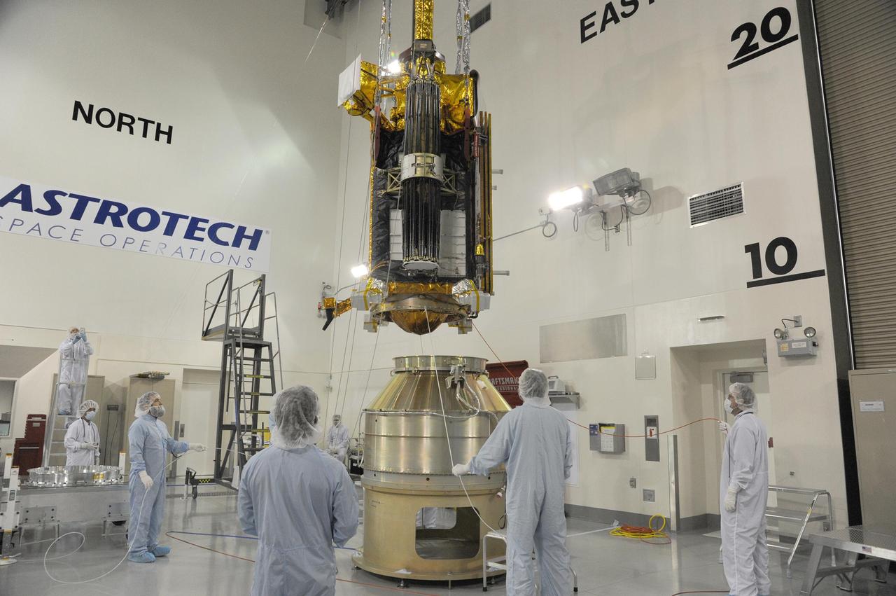
NASA Soil Moisture Active Passive spacecraft is lowered onto the Delta II payload attach structure in the Astrotech payload processing facility at Vandenberg Air Force Base, California, in preparation for launch, to take place no sooner than Jan. 29.
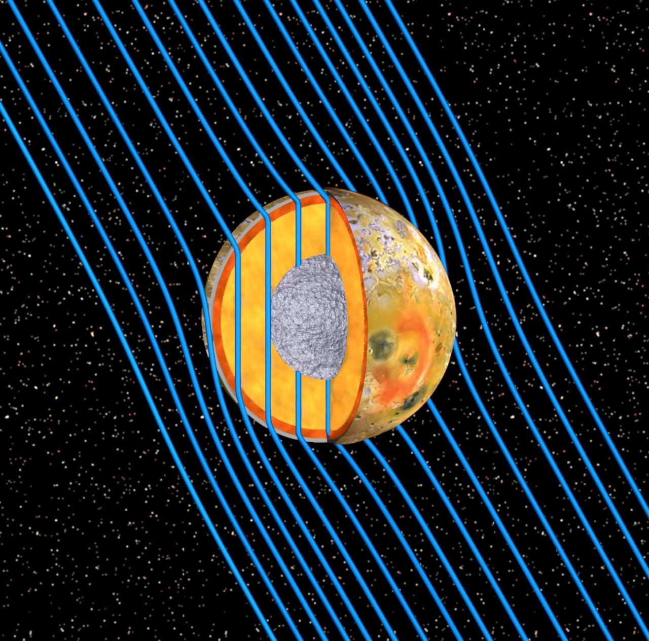
This graphic shows the internal structure of Jupiter moon Io as revealed by data from NASA Galileo spacecraft. Io is bathed in magnetic field lines shown in blue that connect the north polar region of Jupiter to the planet south polar region.
Prometheus is caught in the act of creating gores and streamers in the F ring. Scientists believe that Prometheus and its partner-moon Pandora are responsible for much of the structure in the F ring as shown by NASA Cassini spacecraft. The orbit of Prometheus (53 miles, or 86 kilometers across) regularly brings it into the F ring. When this happens, it creates gores, or channels, in the ring where it entered. Prometheus then draws ring material with it as it exits the ring, leaving streamers in its wake. This process creates the pattern of structures seen in this image. This process is described in detail, along with a movie of Prometheus creating one of the streamer/channel features, in PIA08397. This view looks toward the sunlit side of the rings from about 8.6 degrees above the ringplane. The image was taken in visible light with the Cassini spacecraft narrow-angle camera on Feb. 11, 2014. The view was acquired at a distance of approximately 1.3 million miles (2.1 million kilometers) from Saturn and at a Sun-Saturn-spacecraft, or phase, angle of 147 degrees. Image scale is 8 miles (13 kilometers) per pixel. http://photojournal.jpl.nasa.gov/catalog/PIA18270
This four-frame mosaic shows the ancient impact structure Asgard on Jupiter's moon Callisto. This image is centered at 30 degrees north, 142 degrees west. The Asgard structure is approximately 1700 km across (1,056 mi) and consists of a bright central zone surrounded by discontinuous rings. The rings are tectonic features with scarps near the central zone and troughs at the outer margin. Several large impacts have smashed into Callisto after the formation of Asgard. The very young, bright-rayed crater Burr is located on the northern part of Asgard. This mosaic has been projected to show a uniform scale between the four mosaiced images. The image was processed by Deutsche Forschungsanstalt fuer Luftund Raumfahrt e.V., Berlin, Germany. This image was taken on November 4, 1996, at a distance of 111,891 kilometers (69,070 miles) by the solid state imaging television camera onboard the Galileo spacecraft during its third orbit around Jupiter. http://photojournal.jpl.nasa.gov/catalog/PIA00517
This image captured by NASA 2001 Mars Odyssey spacecraft shows an unnamed crater near Acheron Fossae. The structure of this crater includes a central pit and several concentric rims. Radial grooves can be seen on the ejecta blanket surrounding the crater. Orbit Number: 61879 Latitude: 36.8829 Longitude: 232.325 Instrument: VIS Captured: 2015-11-25 21:21 http://photojournal.jpl.nasa.gov/catalog/PIA20240
1/4th Scale Model of Apollo - Impact Structures Facility Launched from an overhead pendulum device, this Apollo spacecraft was tested in the Impact Structures Facility to determine water-landing characteristics. -- Photograph published in Winds of Change, 75th Anniversary NASA publication (page 91), by James Schultz.
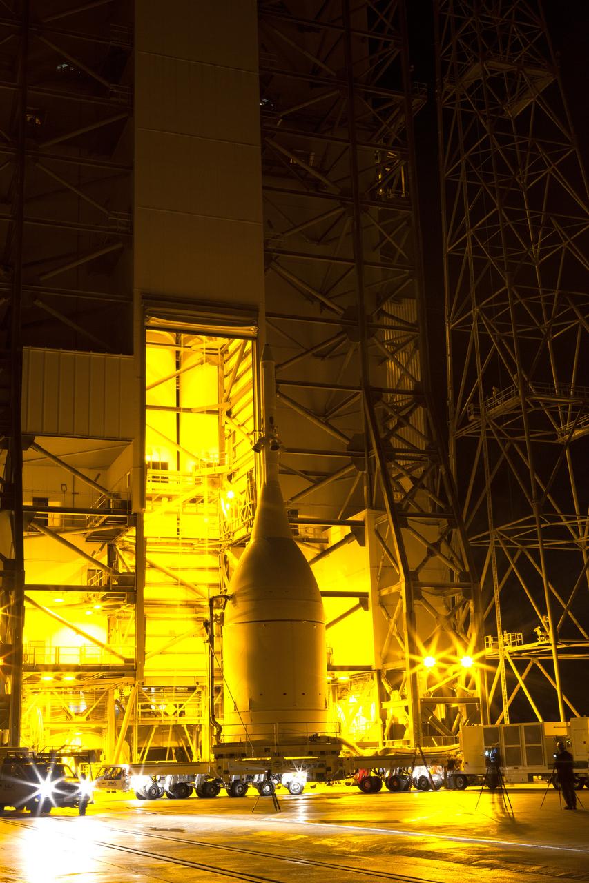
The Orion spacecraft and its transporter stand at the base of the service structure at Space Launch Complex 37 on Nov. 12, 2014. A crane inside the structure will lift Orion off its transporter to hoist it into place atop the Delta IV Heavy rocket that is already assembled at the pad. Part of Batch image transfer from Flickr.
1/4th Scale Model of Apollo - Impact Structures Facility Launched from an overhead pendulum device, this Apollo spacecraft was tested in the Impact Structures Facility to determine water-landing characteristics. -- Photograph published in Winds of Change, 75th Anniversary NASA publication (page 91), by James Schultz.
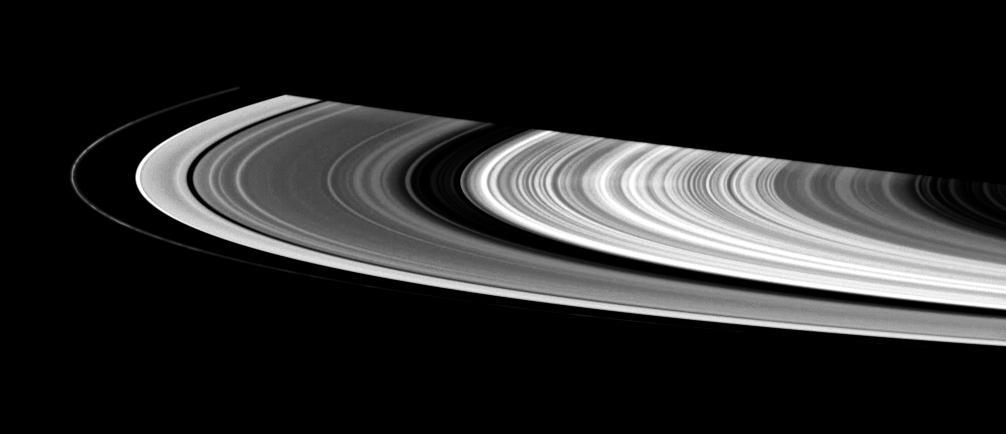
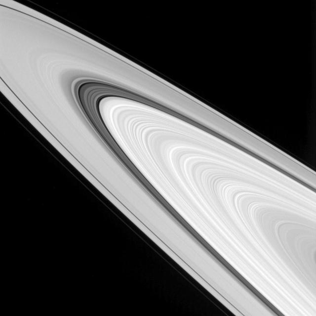
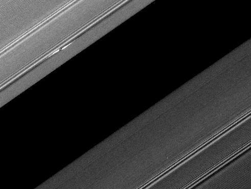
From afar, Saturn's rings look like a solid, homogenous disk of material. But upon closer examination from Cassini, we see that there are varied structures in the rings at almost every scale imaginable. Structures in the rings can be caused by many things, but often times Saturn's many moons are the culprits. The dark gaps near the left edge of the A ring (the broad, outermost ring here) are caused by the moons (Pan and Daphnis) embedded in the gaps, while the wider Cassini division (dark area between the B ring and A ring here) is created by a resonance with the medium-sized moon Mimas (which orbits well outside the rings). Prometheus is seen orbiting just outside the A ring in the lower left quadrant of this image; the F ring can be faintly seen to the left of Prometheus. This view looks toward the sunlit side of the rings from about 15 degrees above the ringplane. The image was taken in red light with the Cassini spacecraft wide-angle camera on Jan. 8, 2015. The view was obtained at a distance of approximately 566,000 miles (911,000 kilometers) from Saturn and at a Sun-Saturn-spacecraft, or phase, angle of 37 degrees. Image scale is 34 miles (54 kilometers) per pixel. http://photojournal.jpl.nasa.gov/catalog/pia18308

Boeing’s Structural Test Article of its CST-100 Starliner spacecraft arrives at the company’s Huntington Beach, California, facilities for evaluations. Built to the specifications of an operational spacecraft, the STA is intended to be evaluated through a series of thorough testing conditions.
Boeing’s Structural Test Article of its CST-100 Starliner spacecraft arrives at the company’s Huntington Beach, California, facilities for evaluations. Built to the specifications of an operational spacecraft, the STA is intended to be evaluated through a series of thorough testing conditions.
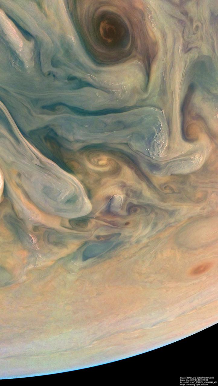
NASA's Juno spacecraft observed the complex colors and structure of Jupiter's clouds as it completed its 43rd close flyby of the giant planet on July 5, 2022. Citizen scientist Björn Jónsson created these two images using raw data from the JunoCam instrument aboard the spacecraft. At the time the raw image was taken, Juno was about 3,300 miles (5,300 kilometers) above Jupiter's cloud tops, at a latitude of about 50 degrees. North is up. At that moment, the spacecraft was traveling at about 130,000 mph (209,000 kilometers per hour) relative to the planet. The image was digitally processed to increase both the color saturation and contrast to sharpen small-scale features and to reduce compression artifacts and noise that typically appear in raw images. This clearly reveals some of the most intriguing aspects of Jupiter's atmosphere, including color variation that results from differing chemical composition, the three-dimensional nature of Jupiter's swirling vortices, and the small, bright "pop-up" clouds that form in the higher parts of the atmosphere. https://photojournal.jpl.nasa.gov/catalog/PIA25018
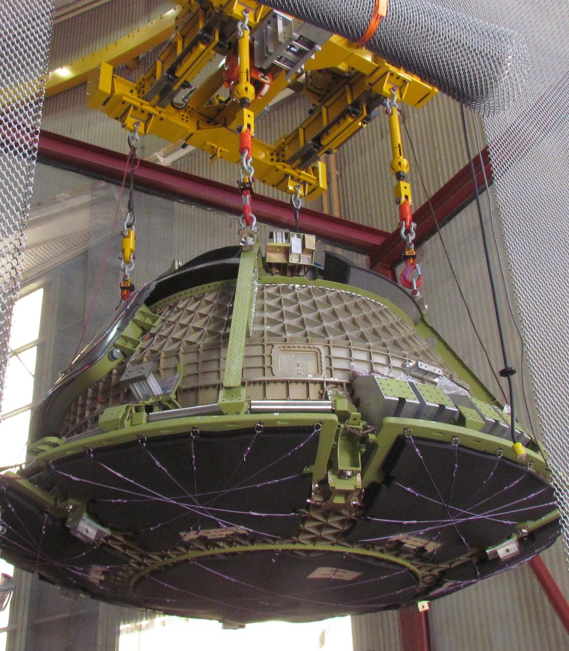
Inside the Neil Armstrong Operations and Checkout Building high bay at NASA's Kennedy Space Center in Florida, operations are underway to lower the Orion crew module adapter structural test article onto the European Space Agency's service module structural test article. After the hardware is attached, the structure will be packed and shipped to Lockheed Martin's Denver facility to undergo testing. The Orion spacecraft will launch atop the agency's Space Launch System rocket on Exploration Mission-1 in 2019.

On June 28, 2019, NASA's InSight lander used its robotic arm to move the support structure for its digging instrument, informally called the "mole." This view was captured by the Instrument Deployment Camera on the spacecraft's robotic arm. Lifting the support structure had been done in three steps, a little bit at a time, to ensure the mole wasn't pulled out of the soil. Moving the structure out of the way will give the InSight team a better look at the mole and allow them to try to help it dig. https://photojournal.jpl.nasa.gov/catalog/PIA23309
Inside the Neil Armstrong Operations and Checkout Building high bay at NASA's Kennedy Space Center in Florida, operations are underway to lower the Orion crew module adapter structural test article onto the European Space Agency's service module structural test article. After the hardware is attached, the structure will be packed and shipped to Lockheed Martin's Denver facility to undergo testing. The Orion spacecraft will launch atop the agency's Space Launch System rocket on Exploration Mission-1 in 2019.
Inside the Neil Armstrong Operations and Checkout Building high bay at NASA's Kennedy Space Center in Florida, operations are underway to lower the Orion crew module adapter structural test article onto the European Space Agency's service module structural test article. After the hardware is attached, the structure will be packed and shipped to Lockheed Martin's Denver facility to undergo testing. The Orion spacecraft will launch atop the agency's Space Launch System rocket on Exploration Mission-1 in 2019.

KEITH HIGGINBOTHAM, STRUCTURAL TEST LEAD FOR THE SLS SPACECRAFT PAYLOAD INTEGRATION AND EVOLUTION OFFICE, IS SHOWN BESIDE TEST STAND 4699 AT THE MARSHALL SPACE FLIGHT CENTER’S WEST TEST AREA. HIGGINBOTHAM WILL BE LEADING STRUCTURAL LOADS TESTING AT TEST STAND 4699 FOR THE CORE STAGE SIMULATER AND THE LAUNCH VEHICLE STAGE ADAPTER. THE TEST SERIES WILL ENSURE EACH STRUCTURE CAN WITHSTAND THE INCREDIBLE STRESSES OF LAUNCH.
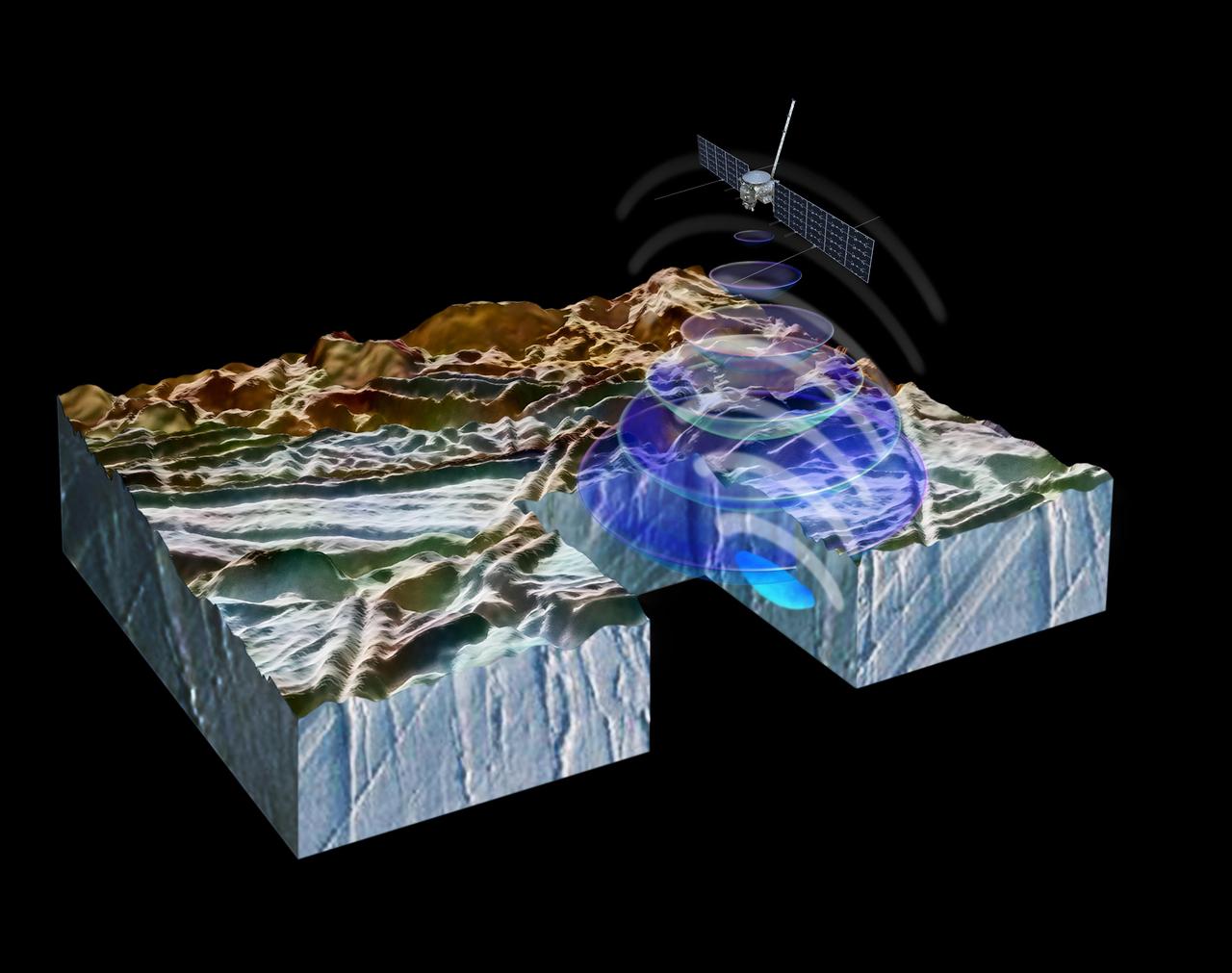
This artist's concept illustrates how NASA's Europa Clipper spacecraft will use radar to peer beneath Europa's ice crust to reveal the structure underneath. Europa Clipper will carry an instrument called the Radar for Europa Assessment and Sounding: Ocean to Near-surface (REASON) that can penetrate beneath the Jovian moon's surface layer, revealing potential pockets of water, cracks, or other features not visible from the outside. Europa Clipper's three main science objectives are to determine the thickness of the moon's icy shell and its interactions with the ocean below, to investigate its composition, and to characterize its geology. The mission's detailed exploration of Europa will help scientists better understand the astrobiological potential for habitable worlds beyond our planet. https://photojournal.jpl.nasa.gov/catalog/PIA26106
This image, taken by NASA's Dawn spacecraft, displays a linear structure trending from northeast to southwest (lower left to upper right). The graben -- what geologists call a linear feature where terrain has dropped -- might be interpreted as a chain of collapsed pits or secondary craters. The crater at center right displays terraced walls, a common feature among the impact sites of Ceres. The image was taken on Oct. 6, 2015, from an altitude of 915 miles (1,470 kilometers). It has a resolution of 450 feet (140 meters) per pixel. The image is located at 31 degrees north latitude, 120 degrees east longitude. http://photojournal.jpl.nasa.gov/catalog/PIA20123
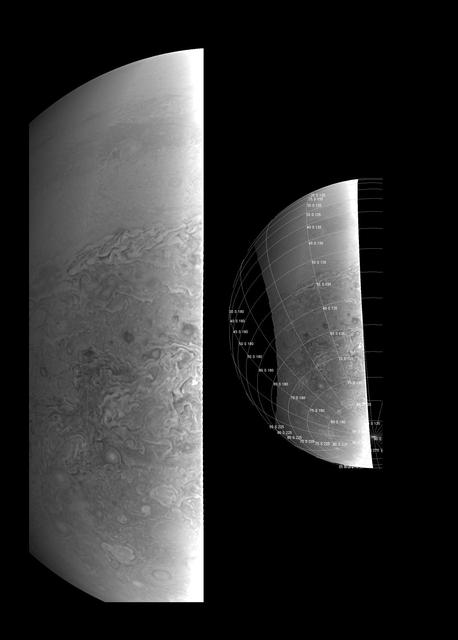
This image provides a close-up view of Jupiter's southern hemisphere, as seen by NASA's Juno spacecraft on August 27, 2016. The JunoCam instrument captured this image with its red spectral filter when the spacecraft was about 23,600 miles (38,000 kilometers) above the cloud tops. The image covers an area from close to the south pole to 20 degrees south of the equator, centered on a longitude at about 140 degrees west. The transition between the banded structures near the equator and the more chaotic polar region (south of about 65 degrees south latitude) can be clearly seen. The smaller version at right of this image shows the same view with a latitude/longitude grid overlaid. This image has been processed to remove shading effects near the terminator -- the dividing line between day and night -- caused by Juno's orbit. http://photojournal.jpl.nasa.gov/catalog/PIA21035
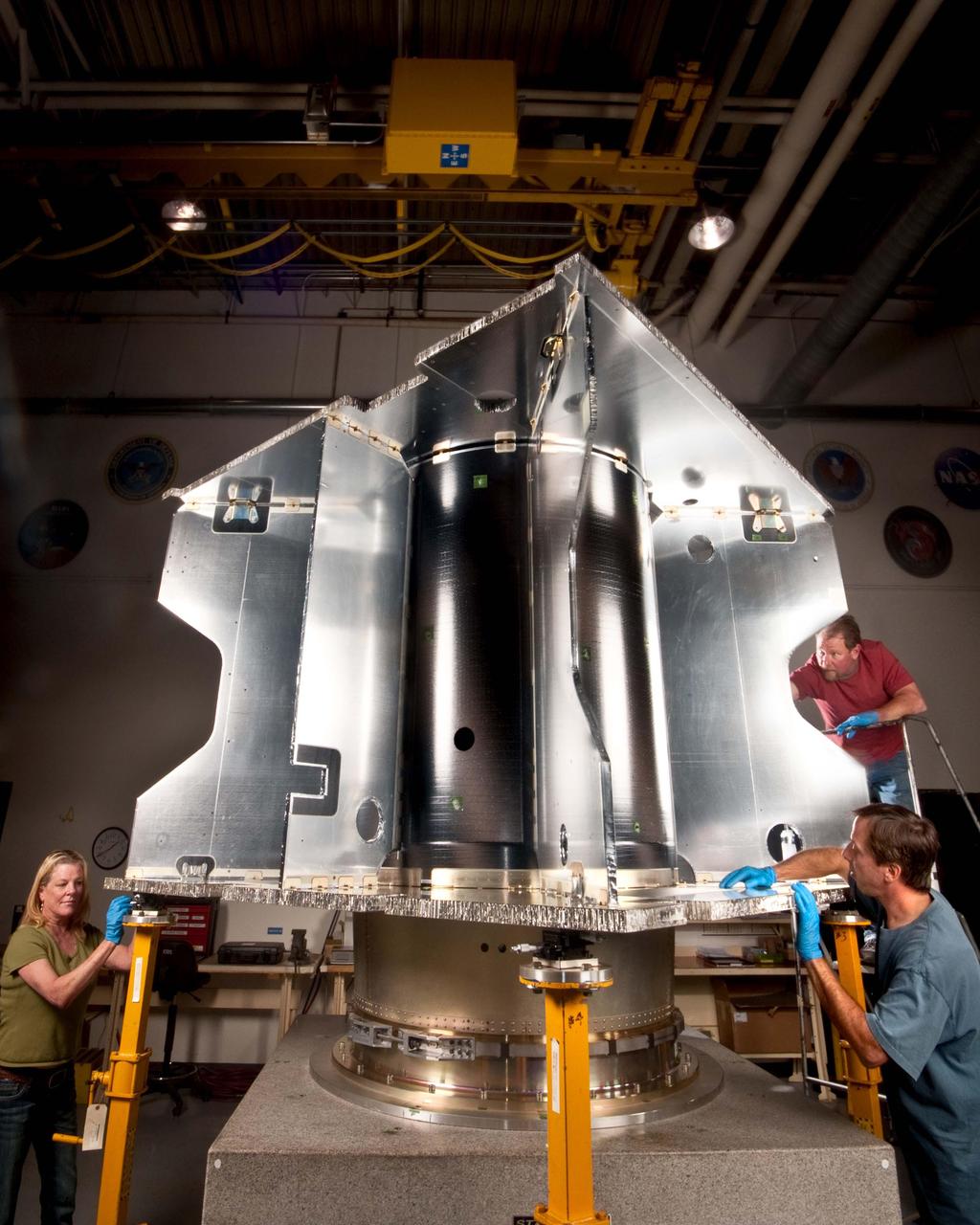
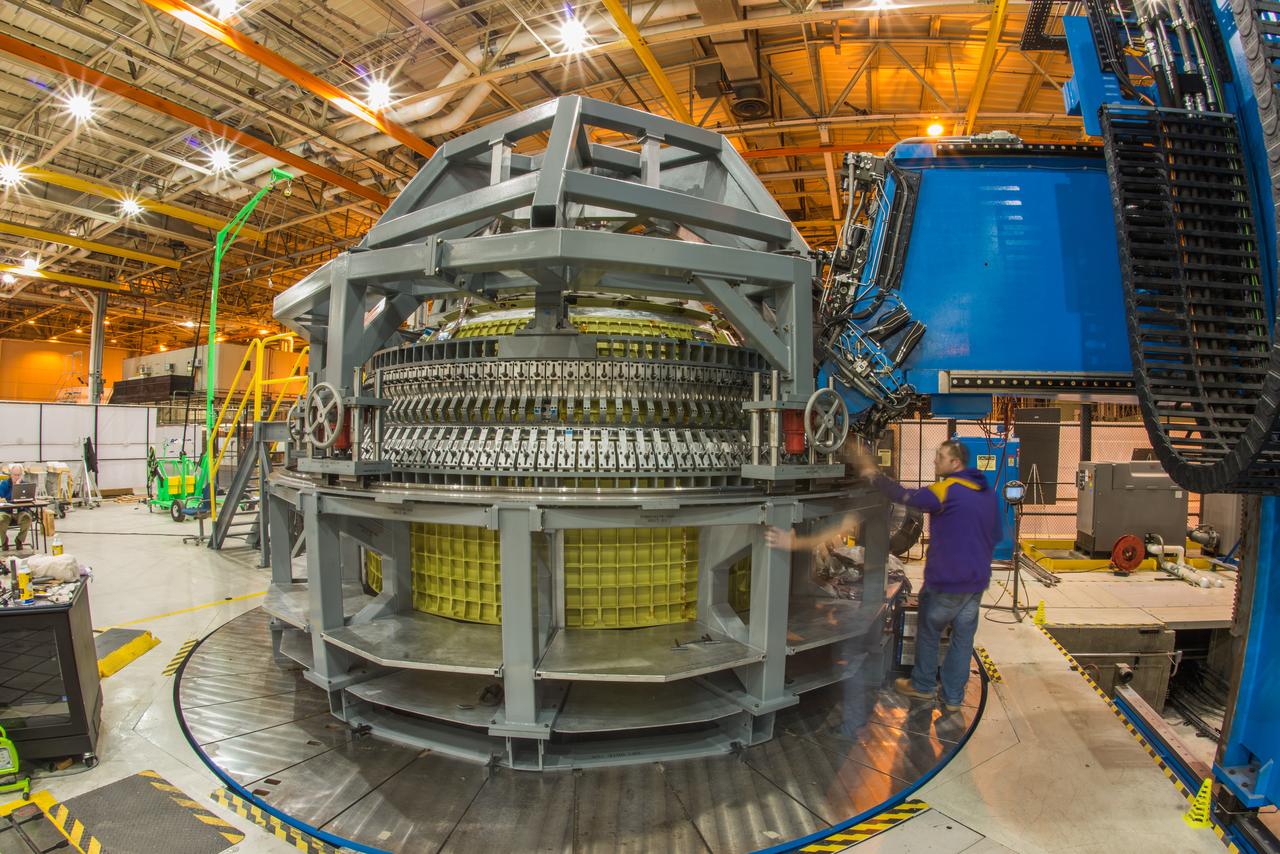
Maxar Technologies completes early fabrication work on the central cylinder structure of the Gateway space station's Power and Propulsion Element (PPE) that will make Gateway the most powerful solar electric spacecraft ever flown.
VANDENBERG AFB, California – NASA's SMAP spacecraft inside the service structure at Space Launch Complex-2 at Vandenberg AFB, California. For more, go to www.nasa.gov/smap Photo credit: USAF
On Jan. 13, 2016, technicians at Michoud Assembly Facility in New Orleans finished welding together the primary structure of the Orion spacecraft destined for deep space on Artemis I, marking another important step on the journey to Mars.