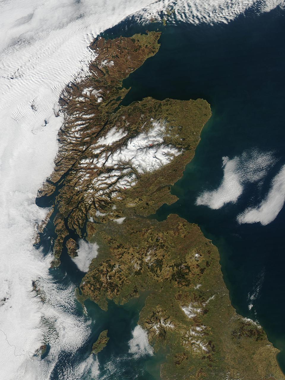
In late February, 2013 the Aqua satellite passed over Scotland as the clouds parted, allowing the Moderate Resolution Imaging Spectroradiometer (MODIS) flying aboard to capture a clear image of the late winter landscape. This image was captured at 1320 UTC (1:20 in the afternoon local time) on February 27. England makes up about the southern third of the image. The border between England and Scotland runs from the River Tweed on the east coast and the Solway Firth along the Cheviot Hills of the west coast. The Solway Firth is an estuary of the Irish Sea, and was filled with tan-colored sediment at the time of this image. Further north on the west coast of Scotland, the Firth of Clyde is hidden under a bank of low clouds (fog). Scotland’s Southern Uplands lie just north of the border and the Central Lowlands just north of that. The Grampian Mountains are found in the center of the country, and the high peaks wear a covering of snow and ice year-round. Finally the Northern Highlands can be seen peeking out from under a large bank of clouds. The Northern Highlands and the Grampian Mountains are separated by a striking feature - the Great Glen Fault. This is a 100 km-long strike-slip fault which runs from Moray Firth in the east to Fort William at the head of Loch Linnhe in the west. The Great Glen contains the United Kingdom’s deepest freshwater loch, the famous Loch Ness. Credit: NASA/GSFC/Jeff Schmaltz/MODIS Land Rapid Response Team <b><a href="http://www.nasa.gov/audience/formedia/features/MP_Photo_Guidelines.html" rel="nofollow">NASA image use policy.</a></b> <b><a href="http://www.nasa.gov/centers/goddard/home/index.html" rel="nofollow">NASA Goddard Space Flight Center</a></b> enables NASA’s mission through four scientific endeavors: Earth Science, Heliophysics, Solar System Exploration, and Astrophysics. Goddard plays a leading role in NASA’s accomplishments by contributing compelling scientific knowledge to advance the Agency’s mission. <b>Follow us on <a href="http://twitter.com/NASA_GoddardPix" rel="nofollow">Twitter</a></b> <b>Like us on <a href="http://www.facebook.com/pages/Greenbelt-MD/NASA-Goddard/395013845897?ref=tsd" rel="nofollow">Facebook</a></b> <b>Find us on <a href="http://instagram.com/nasagoddard?vm=grid" rel="nofollow">Instagram</a></b>
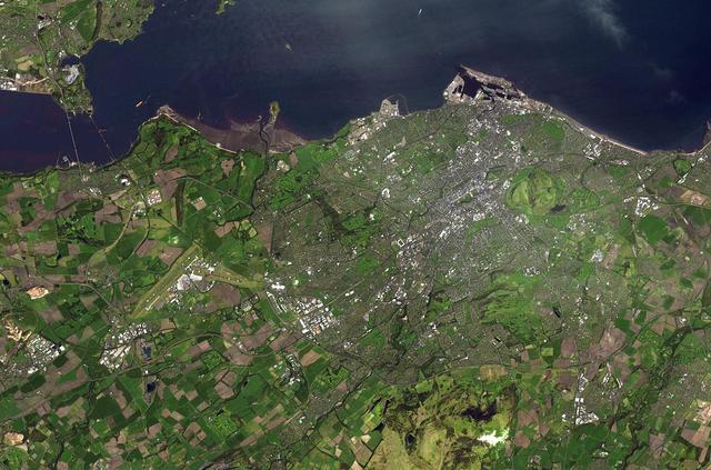
This image, from NASA Terra spacecraft, is of the capital of Scotland, and lies along the Firth of Forth.
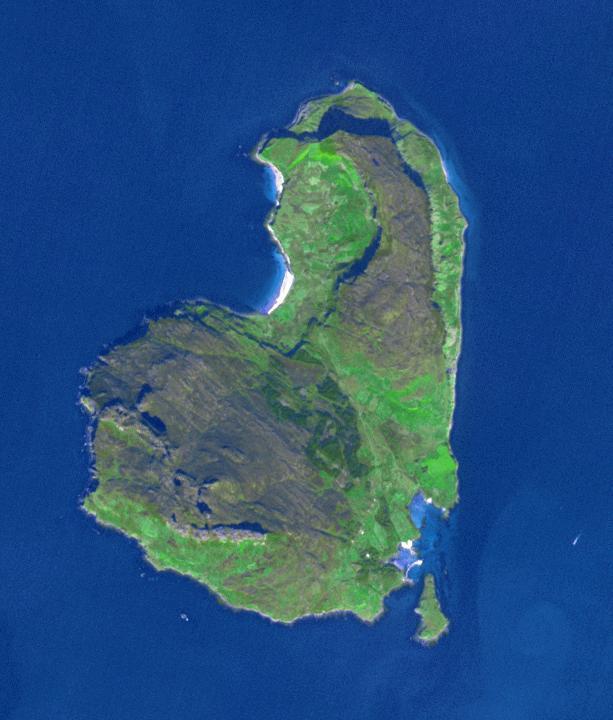
On the small Hebridean island of Eriskay, Scotland, the causeway linking it to the outside world was only completed 20 years ago. The isolation protected the Eriskay Pony, one of the UK's oldest and rarest breeds. It was here that in 1745, Bonny Prince Charlie first set foot in Scotland to launch his uprising to retake the British throne. The image was acquired June 17, 2013, covers an area of 9.2 by 10.2 km, and is located at 57.1 degrees north, 7.3 degrees west. https://photojournal.jpl.nasa.gov/catalog/PIA25639

NASA astronaut Don Pettit, center, walks and smiles, while supported by NASA Flight Surgeons Quinn Dufurrena, left, Rainer Effenhauser, right, and Richard Scheuring, background, during a brief layover in Prestwick, Scotland during his return flight to Houston from Karaganda, Kazakhstan, Sunday, April 20, 2025. Pettit, along with Roscosmos cosmonauts Alexey Ovchinin, and Ivan Vagner, returned to Earth earlier in the day after logging 220 days in space as members of Expeditions 71 and 72 aboard the International Space Station. Photo Credit: (NASA/Bill Ingalls)
Every spring almost 100,000 seabirds come to the small island of Handa, off Scotland's northwest coast. A short ferry ride takes visitors to one of the largest breeding colonies in Europe. Species include guillemots, great skuas, razorbills and puffins. The image was acquired July 2, 2021, covers an area of 15.2 by 16.9 km, and is located at 58.4 degrees north, 5.2 degrees west. https://photojournal.jpl.nasa.gov/catalog/PIA26391
The island of Eigg is one of the small isles in the Scottish Inner Hebrides, south of the Skye peninsula. The main settlement of the 31 km2 island is Cleadale. In 2008, Eigg began a project to become completely energy self-sufficient. Using a combination of wind, water and solar, the population of about 90 now has 24-hour power. The image was acquired 18 September 2015, covers an area of 9.2 by 10.8 km, and is located at 57 degrees north, 6.2 degrees west. https://photojournal.jpl.nasa.gov/catalog/PIA22164
Barra Island Eoligarry Airport is located in the Outer Hebrides, Scotland, U.K. The airport is the only beach runway on the earth, relying on low tide to be open for take-offs and landings. Opened in 1936, there are now two daily flights between Barra and Glasgow. The image was acquired august 24, 2021, covers an area of 15 by 19.5 km, and is located at 57 degrees north, 7.45 degrees west. https://photojournal.jpl.nasa.gov/catalog/PIA26502

iss068e021547 (11/10/2022) --- A view of the ISSET-Nanoracks-UWS 1 investigation shown in the cupola module aboard the International Space Station (ISS). THE Mission Discovery International Space School Educational Trust – The University of the West of Scotland Plant Monitoring Investigation in Microgravity (ISSET-Nanoracks-UWS 1) examines a method to monitor and measure plant growth in microgravity. It uses intelligent, integrated multi-sensing and lighting control tools to monitor growth of five species of plants for seven days.

iss068e021558 (11/10/2022) --- A view of the ISSET-Nanoracks-UWS 1 investigation shown in the cupola module aboard the International Space Station (ISS). THE Mission Discovery International Space School Educational Trust – The University of the West of Scotland Plant Monitoring Investigation in Microgravity (ISSET-Nanoracks-UWS 1) examines a method to monitor and measure plant growth in microgravity. It uses intelligent, integrated multi-sensing and lighting control tools to monitor growth of five species of plants for seven days.
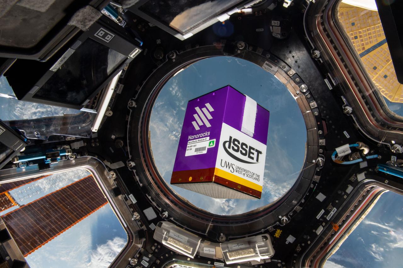
iss068e021563 (11/10/2022) --- A view of the ISSET-Nanoracks-UWS 1 investigation shown in the cupola module aboard the International Space Station (ISS). THE Mission Discovery International Space School Educational Trust – The University of the West of Scotland Plant Monitoring Investigation in Microgravity (ISSET-Nanoracks-UWS 1) examines a method to monitor and measure plant growth in microgravity. It uses intelligent, integrated multi-sensing and lighting control tools to monitor growth of five species of plants for seven days.

Inside the Veggie flight laboratory in the Space Station Processing Facility at NASA’s Kennedy Space Center in Florida, Matthew Romeyn, a NASA Pathways intern from the University of Edinburgh in Scotland, harvests a portion of the 'Outredgeous' red romaine lettuce from the Veg-03 ground control unit. The purpose of the ground Veggie system is to provide a control group to compare against the lettuce grown in orbit on the International Space Station. Veg-03 will continue NASA’s deep space plant growth research to benefit the Earth and the agency’s journey to Mars.

iss068e021559(11/10/2022) --- A view of the ISSET-Nanoracks-UWS 1 investigation shown in the cupola module aboard the International Space Station (ISS). THE Mission Discovery International Space School Educational Trust – The University of the West of Scotland Plant Monitoring Investigation in Microgravity (ISSET-Nanoracks-UWS 1) examines a method to monitor and measure plant growth in microgravity. It uses intelligent, integrated multi-sensing and lighting control tools to monitor growth of five species of plants for seven days.

Artist illustration of the X-59 in flight above the clouds with land below, flying left.
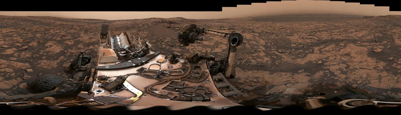
After snagging a new rock sample on August 9, 2018 (Sol 2137), NASA's Curiosity rover surveyed its surroundings on Mars, producing a 360-degree panorama of its current location on Vera Rubin Ridge. The scene is presented with a color adjustment that approximates white balancing, to resemble how the rocks and sand would appear under daytime lighting conditions on Earth. Two versions are included here: one with scale bars, and one without. The panorama includes umber skies, darkened by a fading global dust storm. It also includes a rare view by the Mast Camera of the rover itself, revealing a thin layer of dust on Curiosity's deck. In the foreground is the rover's most recent drill target, named "Stoer" after a town in Scotland near where important discoveries about early life on Earth were made in lakebed sediments. https://photojournal.jpl.nasa.gov/catalog/PIA22545
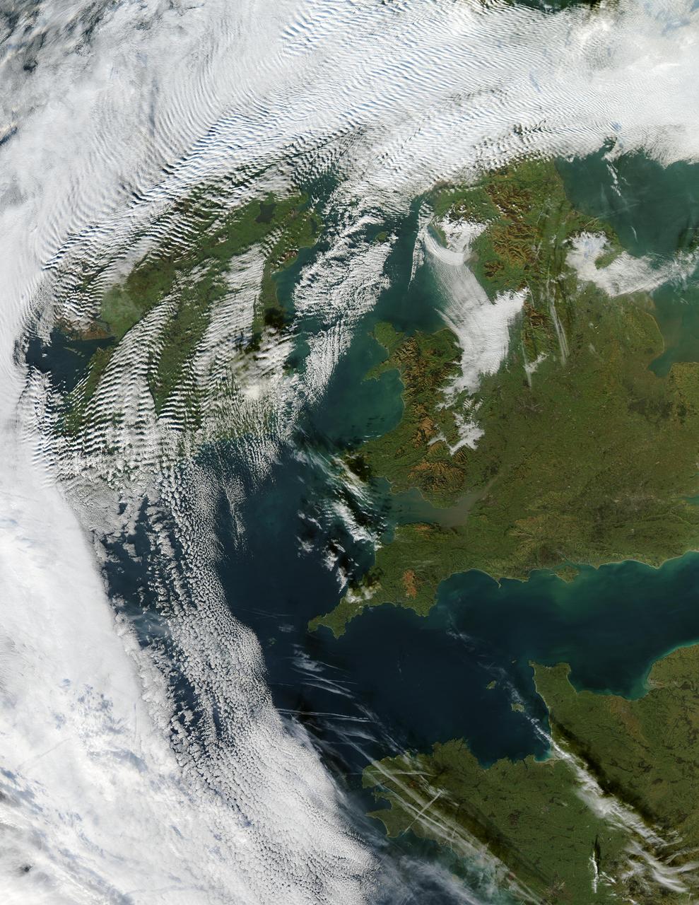
Visualization Date 2003-12-18 Clouds ripple over Ireland and Scotland in a wave pattern, similar to the pattern of waves along a seashore. The similarity is not coincidental — the atmosphere behaves like a fluid, so when it encounters an obstacle, it must move around it. This movement forms a wave, and the wave movement can continue for long distances. In this case, the waves were caused by the air moving over and around the mountains of Scotland and Ireland. As the air crested a wave, it cooled, and clouds formed. Then, as the air sank into the trough, the air warmed, and clouds did not form. This pattern repeated itself, with clouds appearing at the peak of every wave. Other types of clouds are also visible in the scene. Along the northwestern and southwestern edges of this true-color image from December 17, 2003, are normal mid-altitude clouds with fairly uniform appearances. High altitude cirrus-clouds float over these, casting their shadows on the lower clouds. Open- and closed-cell clouds formed off the coast of northwestern France, and thin contrail clouds are visible just east of these. Contrail clouds form around the particles carried in airplane exhaust. Fog is also visible in the valleys east of the Cambrian Mountains, along the border between northern/central Wales and England. This is an Aqua MODIS image. Sensor Aqua/MODIS Credit Jacques Descloitres, MODIS Rapid Response Team, NASA/GSFC For more information go to: <a href="http://visibleearth.nasa.gov/view_rec.php?id=6146" rel="nofollow">visibleearth.nasa.gov/view_rec.php?id=6146</a>
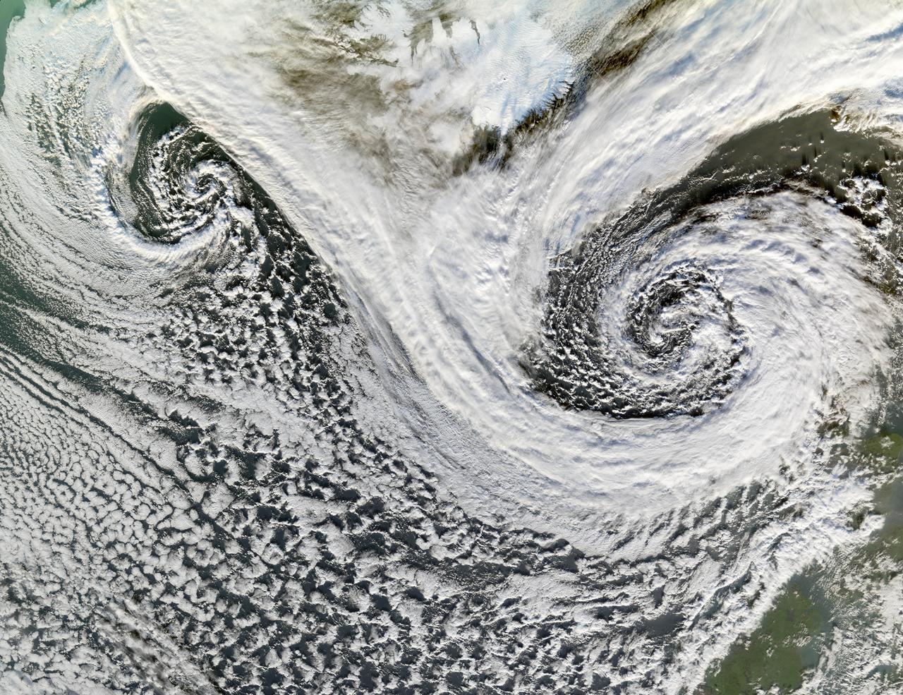
A cyclone is a low-pressure area of winds that spiral inwards. Although tropical storms most often come to mind, these spiraling storms can also form at mid- and high latitudes. Two such cyclones formed in tandem in November 2006. The Moderate Resolution Imaging Spectroradiometer (MODIS) flying onboard NASA’s Terra satellite took this picture on November 20. This image shows the cyclones south of Iceland. Scotland appears in the lower right. The larger and perhaps stronger cyclone appears in the east, close to Scotland. Cyclones at high and mid-latitudes are actually fairly common, and they drive much of the Earth’s weather. In the Northern Hemisphere, cyclones move in a counter-clockwise direction, and both of the spiraling storms in this image curl upwards toward the northeast then the west. The eastern storm is fed by thick clouds from the north that swoop down toward the storm in a giant “V” shape on either side of Iceland. Skies over Iceland are relatively clear, allowing some of the island to show through. South of the storms, more diffuse cloud cover swirls toward the southeast. Credit: NASA <b><a href="http://www.nasa.gov/centers/goddard/home/index.html" rel="nofollow">NASA Goddard Space Flight Center</a></b> is home to the nation's largest organization of combined scientists, engineers and technologists that build spacecraft, instruments and new technology to study the Earth, the sun, our solar system, and the universe. <b>Follow us on <a href="http://twitter.com/NASA_GoddardPix" rel="nofollow">Twitter</a></b> <b>Join us on <a href="http://www.facebook.com/pages/Greenbelt-MD/NASA-Goddard/395013845897?ref=tsd" rel="nofollow">Facebook</a></b>
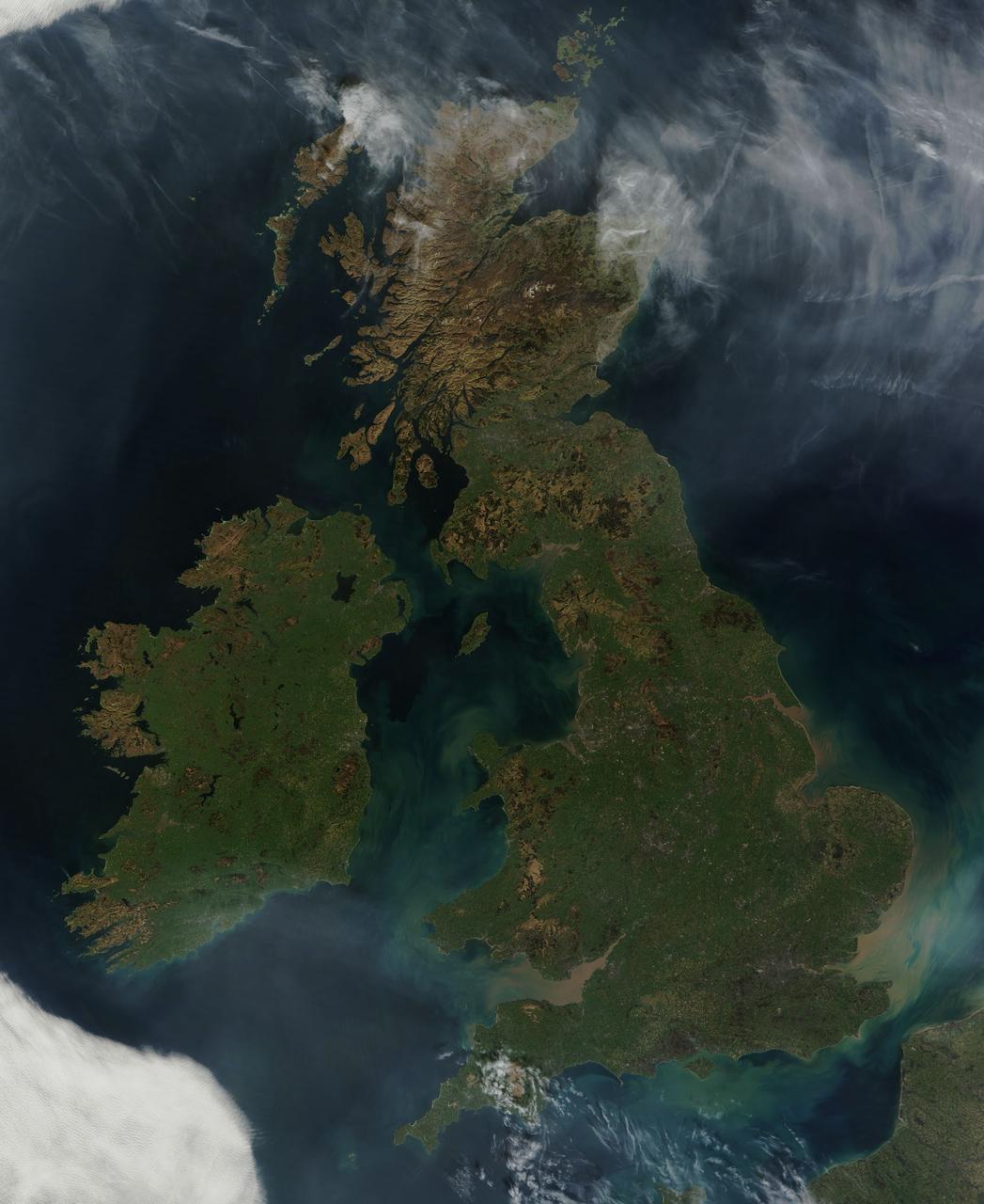
NASA image acquired March 26, 2012 This nearly cloud-free view of Great Britain and Ireland was acquired by the Moderate Resolution Imaging Spectroradiometer (MODIS) aboard NASA’s Terra satellite on March 26, 2012. Just a few days into spring, most of the land appears green, although not quite as brilliant as the summertime hues that give Ireland the nickname “the Emerald Island”. The islands of Ireland (west) and Great Britain (east) are separated by the Irish Sea, which is filled with the turquoise, green and tan swirls typical of sediment, although blooming algae could also contribute some color to the waters. To the southeast, the English Channel separates the island of Great Britain from France (south) and Belgium (north). London can be seen as a gray circle situated inland on the tan-colored River Thames. The sediment from the Thames flows into the English Channel due east of London. The United Kingdom is made up of Wales, Scotland and England, all located primarily on the island of Great Britain, and of Northern Ireland, which comprises the northern section of the island of Ireland. Dublin, in the Republic of Ireland, can be seen as a gray smudge on the eastern coast of the island. Almost due west Galway can be seen as a linear gray streak on the northern coast of Galway Bay, with the blue waters of Loch Corrib to the north. Most of the United Kingdom and Ireland are part of the Celtic broadleaf forest ecoregion, where acid-loving oak and mixed oak forests abound, along with fen and swamp forests and ombrotrophic mires. A portion of the Scottish Highlands, in the north of Great Britain, are covered by the Caledon conifer forest ecoregion. The Caledonia conifers once covered a large area of Scotland, but now only about 1% of the original forest survives, mostly high in the cooler areas of the Highlands. NASA/GSFC/Jeff Schmaltz/MODIS Land Rapid Response Team <b><a href="http://www.nasa.gov/audience/formedia/features/MP_Photo_Guidelines.html" rel="nofollow">NASA image use policy.</a></b> <b><a href="http://www.nasa.gov/centers/goddard/home/index.html" rel="nofollow">NASA Goddard Space Flight Center</a></b> enables NASA’s mission through four scientific endeavors: Earth Science, Heliophysics, Solar System Exploration, and Astrophysics. Goddard plays a leading role in NASA’s accomplishments by contributing compelling scientific knowledge to advance the Agency’s mission. <b>Follow us on <a href="http://twitter.com/NASA_GoddardPix" rel="nofollow">Twitter</a></b> <b>Like us on <a href="http://www.facebook.com/pages/Greenbelt-MD/NASA-Goddard/395013845897?ref=tsd" rel="nofollow">Facebook</a></b> <b>Find us on <a href="http://instagrid.me/nasagoddard/?vm=grid" rel="nofollow">Instagram</a></b>
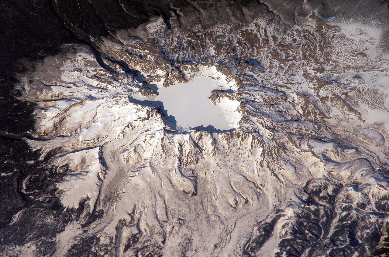
ISS006-E-43366 (4 April 2003) --- This view featuring Baitoushan Volcano, China and North Korea, was photographed by an Expedition 6 crewmember on the International Space Station (ISS). One of the largest known Holocene eruptions occurred at Baitoushan Volcano (also known as Changbaishan in China and P’aektu-san in Korea) about 1000 A.D., with erupted material deposited as far away as northern Japan – a distance of approximately 1200 kilometers. The eruption also created the 4.5 kilometer diameter, 850 meters deep summit caldera of the volcano that is now filled with the waters of Lake Tianchi (or Sky Lake). This oblique photograph was taken during the winter season, and snow highlights frozen Lake Tianchi along with lava flow lobes along the southern face of the volcano. Baitoushan last erupted in 1702 and is considered a dormant volcano. Gas emissions were reported from the summit and nearby hot springs in 1994, but no evidence of renewed activity of the volcano was observed. The Chinese-Korean border runs directly through the center of the summit caldera, and the mountain is considered sacred by the dominantly Korean population living near the volcano. Lake Tianchi is a popular resort destination, both for its natural beauty and alleged sightings of unidentified creatures living in its depths (similar to legendary Loch Ness Monster in Scotland).
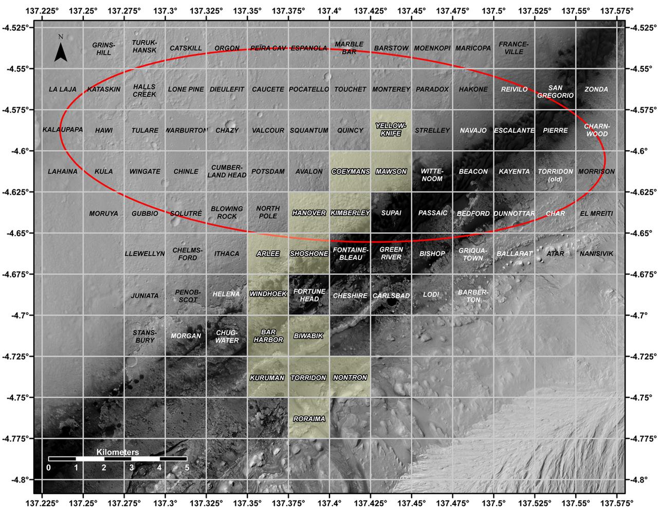
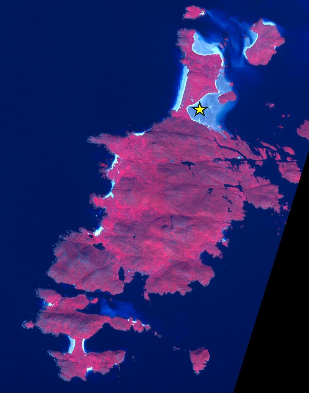
This map shows all the quadrant themes for NASA's Curiosity Mars rover, which is currently in the Roraima quadrant seen at the bottom. The red oval indicates the landing ellipse where the rover was targeted to touch down in 2012. The yellow-tinted quadrants are areas the rover has driven through since then. Themes are chosen in advance of the rover's arrival in a new quadrant; the rover's path couldn't be planned until after the team knew where it landed. Martian latitude and longitude is provided around the outside of the map. With the Curiosity mission, scientists began using quadrant themes to organize the long lists of unofficial nicknames needed to catalog its observations, whether hills, craters, boulders, rocks, and even tiny features on rock surfaces. Scientist deplete these lists of names quickly – especially with Curiosity, which has used more than 10,000 names over nearly 11 years of exploring Mars. Different science "targets" all require names – including targets for the rover's cameras, the rocks on which it places its arm instruments and drill, and the surfaces it zaps with its laser instrument. Curiosity's team chooses quadrant themes based on sites of geological interest on Earth. Its current quadrant, Roraima, is named for the northernmost state of Brazil, and for Mount Roraima, the highest peak in the Pacaraima mountains, located near the border of Venezuela, Brazil, and Guyana. The sulfate-enriched region Curiosity is currently exploring, with its flat-topped hills and steep slopes, reminded the rover team of the "table-top" mountains in the Pacaraima range. This is the first quadrant theme the team has chosen related to South America. Previously explored quadrants include Torridon, based on sites in Scotland, and Nontron, based on the French region where the town of Nontron can be found. While in the Nontron quadrant, which was located in a clay-enriched region, Curiosity drilled a rock sample that included a notable amount of nontronite – a clay mineral that was first discovered on Earth near Nontron. Each quadrant is 0.025 degrees of latitude and longitude, or approximately 0.7 miles (1.2 kilometers) on each side. https://photojournal.jpl.nasa.gov/catalog/PIA25914
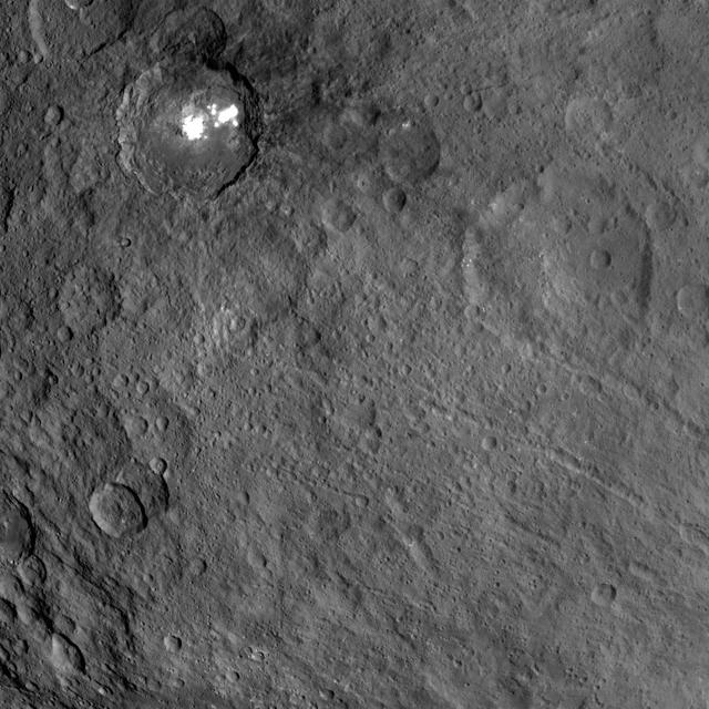
This view obtained by NASA's Dawn spacecraft during its Survey orbit illustrates the diversity and complexity of Ceres' geology. It shows familiar features: Occator Crater with its bright deposits (called faculae) of carbonates and other salts, a series of linear features (at right) called Samhain Catenae, and another large crater on the right side of the image called Kirnis. A relatively fresh crater called Lociyo, superimposed on an older crater, can be seen toward the bottom left of the picture. Studying the morphologies and relationships between various types of geological features can help scientists reconstruct Ceres' history. Occator appears to be one of the youngest features in this picture, except for a couple of smaller craters. The 71-mile-wide (115-kilometer-wide) Kirnis Crater on the other hand is an old, eroded crater. It owes its peculiar polygonal shape in part to its overlap with one of the Samhain Catenae. This illustrates the role of fractures in driving the geometry of some of Ceres' craters. The origin of these particular catenae is not understood yet, and is not necessarily related to the Pongal Catena. Kirnis Crater is named after a Lithuanian spirit-guardian of cherry trees, whereas the Samhain Catenae refer to a Gaelic festival organized at the end of the harvest season. It was observed in Ireland and Scotland during seven days in October and November, nearly halfway between the autumn equinox and the winter solstice. This picture was obtained on June 25, 2015, from an altitude of 2,700 miles (4,400 kilometers). It is centered at 1.7 degrees north latitude, and 249 degrees east longitude. https://photojournal.jpl.nasa.gov/catalog/PIA21409
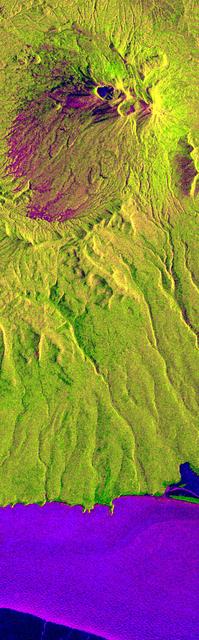
This is an X-band seasonal image of the Maly Semlyachik volcano, which is part of the Karymsky volcano group on Kamchatka peninsula, Russia. The image is centered at 54.2 degrees north latitude and 159.6 degrees east longitude. This image was acquired by the Spaceborne Imaging Radar-C and X-band Synthetic Aperture Radar (SIR-C/X-SAR) aboard the space shuttle Endeavour on April 9, 1994, during the first flight of the radar system, and on September 30, 1994, during the second flight. The image channels have been assigned the following colors: red corresponds to data acquired on April 9; green corresponds to data acquired on September 30; and blue corresponds to the ratio between data from April 9 and September 30, 1994. Kamchatka is twice as large as England, Scotland and Wales combined and is home to approximately 470,000 residents. The region is characterized by a chain of volcanoes stretching 800 kilometers (500 miles) across the countryside. Many of the volcanoes, including the active Maly Semlyachik volcano in this image, have erupted during this century. But the most active period in creating the three characteristic craters of this volcano goes back 20,000, 12,000 and 2,000 years ago. The highest summit of the oldest crater reaches about 1,560 meters (1,650 feet). The radar images reveal the geological structures of craters and lava flows in order to improve scientists' knowledge of these sometimes vigorously active volcanoes. This seasonal composite also highlights the ecological differences that have occurred between April and October 1994. In April the whole area was snow-covered and, at the coast, an ice sheet extended approximately 5 kilometers (3 miles) into the sea. The area shown surrounding the volcano is covered by low vegetation much like scrub. Kamchatka also has extensive forests, which belong to the northern frontier of Taiga, the boreal forest ecosystem. This region plays an important role in the world's carbon cycle. Trees require 60 years to mature in Kamchatka's 120-day growing season. The forest industry is managing these forests and practicing selective cutting to allow younger trees time to grow and reseed. X-SAR images will aid in mapping these deforested areas and in encouraging further recultivation efforts. http://photojournal.jpl.nasa.gov/catalog/PIA01728
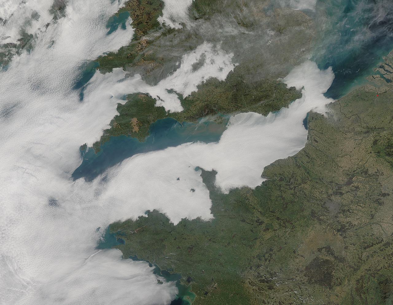
A thick blanket of low clouds covered the English Channel, Celtic Sea and Irish Sea on March 13, 2014. The fog also crept over major cities in the United Kingdom and Ireland. While citizens living in parts of Ireland, England, Wales, Scotland and Northern Ireland were posting ground-based photos of fog-shrouded landscape on social media, the internet and news outlets, the scene was also captured from space. The Moderate Resolution Imaging Spectroradiometer (MODIS) aboard NASA’s Aqua captured this true-color image of the cloudy day at 13:00 UTC (1:00 p.m. in London) on that same day. The dense fog (low clouds) affected air travel, causing the cancellation of hundreds of flights going through London City Airport, where visibility was reported at less than 100 meters (328 ft) – less than the length of an American football field. Flights were also cancelled at Heathrow, Gatwick and Manchester. A private helicopter flying to Northern Ireland went down in by the fog near the Norfolk-Suffolk border, with loss of four lives. Driving was little better in many areas, causing the Met Office to issue a yellow weather warning and to caution drivers of difficult conditions. The lowest visibility of the day was reported at Roches Point weather station. Located at the southeastern tip of Cork Harbor, Ireland, the station reported visibility of less than 50 meters (164 ft) – the length of an Olympic size swimming pool. In this image, the fog-covered Celtic Sea is located in the southwest. Ireland lies under tendrils of low cloud in the northwest corner of the image. Banks of clouds part around England, near the center of the image, and southern Wales (top and center) completely under the foggy blanket. Fog also creeps over the coasts of France, Belgium and the Netherlands on the east side of the English Channel. Credit: NASA/GSFC/Jeff Schmaltz/MODIS Land Rapid Response Team <b><a href="http://www.nasa.gov/audience/formedia/features/MP_Photo_Guidelines.html" rel="nofollow">NASA image use policy.</a></b> <b><a href="http://www.nasa.gov/centers/goddard/home/index.html" rel="nofollow">NASA Goddard Space Flight Center</a></b> enables NASA’s mission through four scientific endeavors: Earth Science, Heliophysics, Solar System Exploration, and Astrophysics. Goddard plays a leading role in NASA’s accomplishments by contributing compelling scientific knowledge to advance the Agency’s mission. <b>Follow us on <a href="http://twitter.com/NASAGoddardPix" rel="nofollow">Twitter</a></b> <b>Like us on <a href="http://www.facebook.com/pages/Greenbelt-MD/NASA-Goddard/395013845897?ref=tsd" rel="nofollow">Facebook</a></b> <b>Find us on <a href="http://instagram.com/nasagoddard?vm=grid" rel="nofollow">Instagram</a></b>