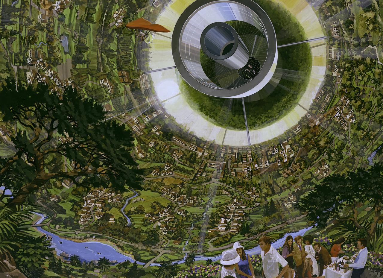
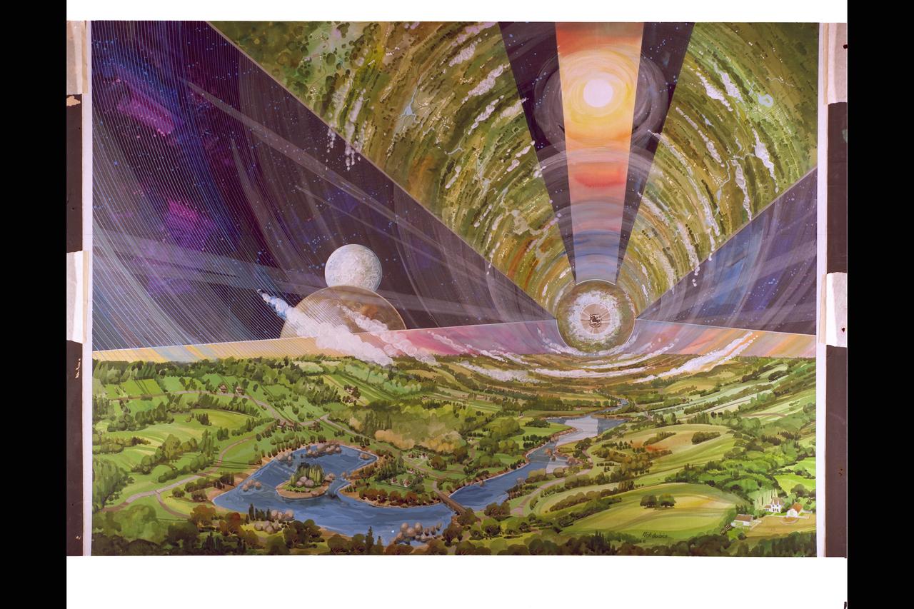
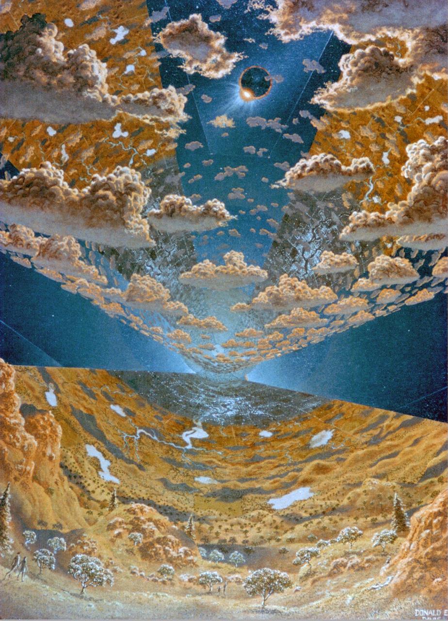
ARTIST: Rick Guidice Space Colonization; inside the sphere gravity is strongest along the equator. as on moves toward the center gravity lessens and one could fly easily. Sunlight enters as shown by the large fuzzy ring. The central tube connects to other sections of the colony.
Artist: Rick Guidice Building a Space Colony
Artist: Rick Guidice Building a Space Colony
A colony of hot, young stars is stirring up the cosmic scene in this new picture from NASA Spitzer Space Telescope. The image shows the Orion nebula, a happening place where stars are born.

Artist rendering Torus Sphere. Space Colony Concept. Exterior view of several neighboring colonies. ref: NASA SP-413; Space Settlements: A Design Study
Exterior View of Colony. Space Colonization - Artwork.
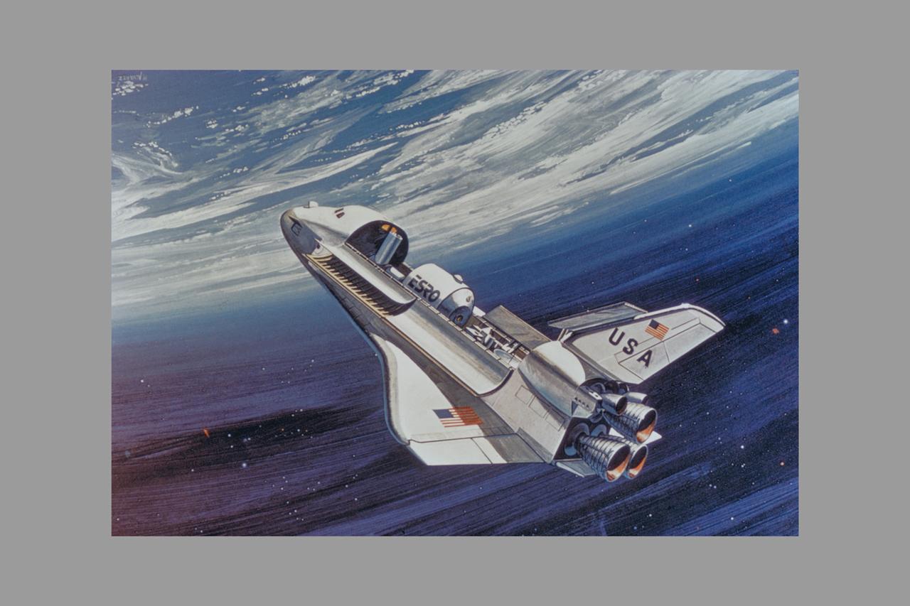
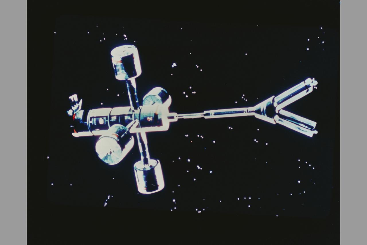
Shuttle Service (view of spacecraft). Space shuttle delivers part for Space Colony
Artist: Rick Guidice interior of Torus wheel (L-5) Space Colonization Module

NASA Artwork By: Don Davis Space Colony: Torus Wheel - Large assemblies can be put together in space. On this part of the rim panels of a colony are being fitted in place. The small vehicles are called ANTS for Assembly non-thethered ships
NASA Art by Artist Rick Guidice Space Colonization - Torus Wheel Toroidal Colonies
Interior View of L-5 Torus Sphere Colony. Space Colonization. Artwork by Don Davis
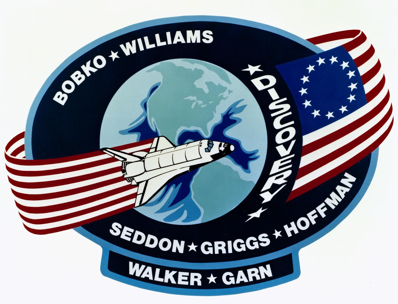
The dominant features of the STS-51D emblem are an orbit formed by a Colonial American flag and a Space Shuttle. The flag in orbit signifies the U.S. flag to indicate that it comes from this country and the American people. The original 13- star flag is used to symbolize a continuity of technical achievement and progress since colonial times. The name Discovery preceding the flag represents the spirit of Discovery and exploration of new frontiers which have been a hallmark of American people even before they were formed together as a nation.

Space shuttle STS-121 FIT (Fly Immunity and Tumors) payload. Using Drosophila (fruit fly) to complete the experiments. Matt Lera prepares food for culturing Drosphila (fruit fly) colony during fight
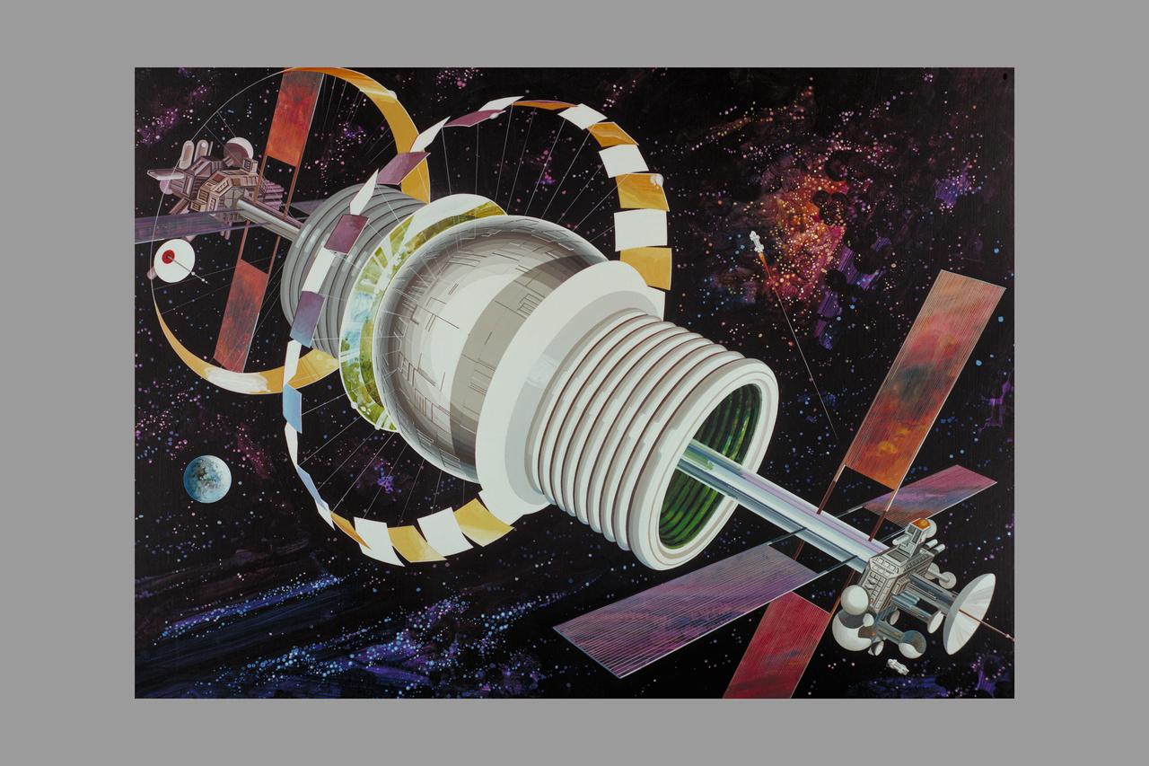
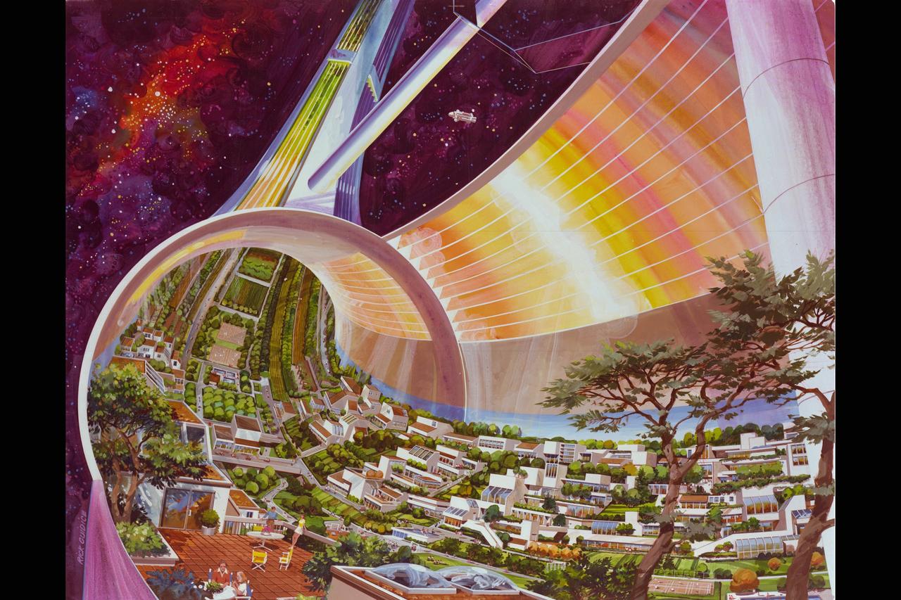
Artist: Rick Guidice Space Colonization - Bernal Sphere - The residential area is in the central sphere. Farming regions are in the 'tires.' Mirrors reflect sunlight into the habitat and farms. The large flat panels radiate away extra heat into space, and panels of solar cells provide electricity. Factories and docks for spaceships are at either end of the long central tube. (NOTE: art printed in Book 'Space Colony - Frontier of the 21st Century by Franklyn M. Branley)
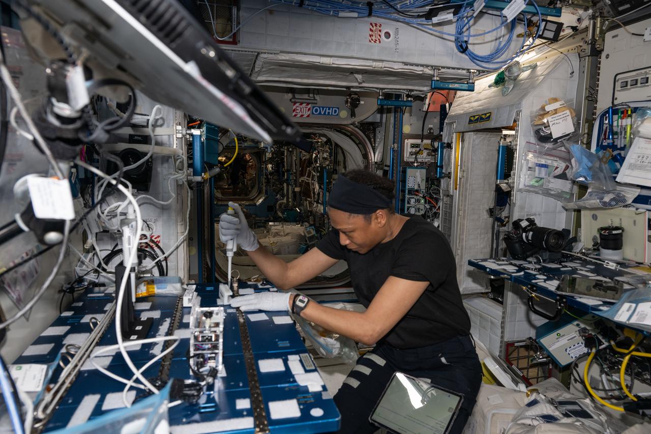
iss071e041625 (April 24, 2024) --- NASA astronaut and Expedition 71 Flight Engineer Jeanette Epps extracts DNA samples from bacteria colonies for genomic analysis aboard the International Space Station's Harmony module. The research work may help researchers understand how bacteria adapts to weightlessness and develop ways to protect space crews and humans on Earth.
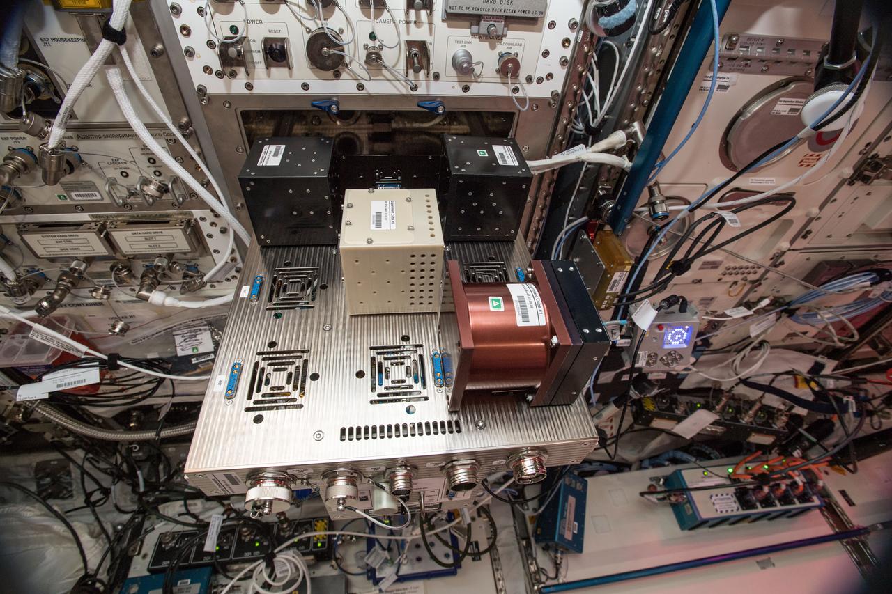
iss057e132633 (12/13/2018) --- A photo of the Study of the Gravity’s Effect on Bacteria (ICE Cubes Hydra-2 Bacteria Biomining) onboard the International Space Station (ISS). The ICE Cubes Hydra-2 Bacteria Biomining investigation studies the effects of microgravity on several strains of an ancient type of bacteria that does not use oxygen. The investigation is evaluating the use of these bacteria to produce methane on asteroids for use as a propellant or fuel. The Experiment Cube measures the size of the bacterial colonies in the growth chamber before and after flight.
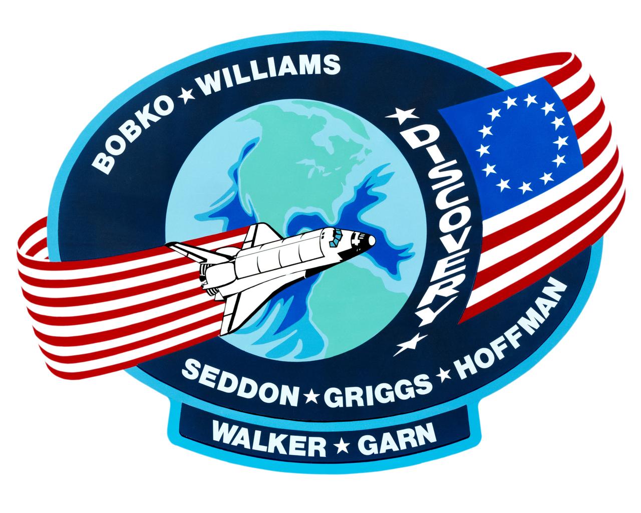
S85-28989 (March 1985) --- The dominant features of the STS-51D emblem are an orbit formed by a Colonial American flag and a space shuttle. The flag in orbit signifies the U.S. flag to indicate that it comes from this country and the American people. The original 13-star flag is used to symbolize a continuity of technical achievement and progress since colonial times. The name Discovery preceding the flag represents the spirit of Discovery and exploration of new frontiers which have been a hallmark of American people even before they were formed together as a nation. The crew members are Karol J. Bobko, Donald E. Williams, Rhea Seddon, S. David Griggs and Jeffrey A. Hoffman of NASA; and Charles D. Walker, representing McDonnell Douglas Corporation; and U. S. Senator Jake Garn. The NASA insignia design for space shuttle flights is reserved for use by the astronauts and for other official use as the NASA Administrator may authorize. Public availability has been approved only in the forms of illustrations by the various news media. When and if there is any change in this policy, which is not anticipated, the change will be publicly announced. Photo credit: NASA
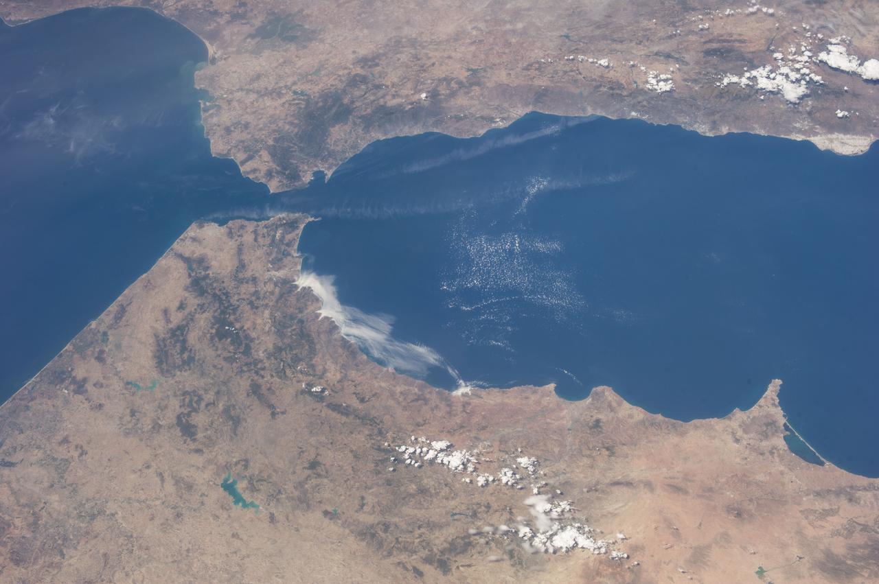
ISS036-E-036611 (23 Aug. 2013) --- One of the Expedition 36 crew members aboard the International Space Station on Aug. 23 exposed this image of the Strait of Gibraltar, where Europe and Africa meet and where the Atlantic Ocean waters flow through the strait into the Mediterranean Sea. A popular photographic target of astronauts has always been the Strait of Gibraltar, easily spotted at left center in this wide photograph, shot from the International Space Station. Spain is to the north (top) and Morocco to the south. The strait is 36 miles (58 kilometers) long and slims down to 8 miles (13 kilometers) at it?s most narrow point. The British colony of Gibraltar is north of the strait.
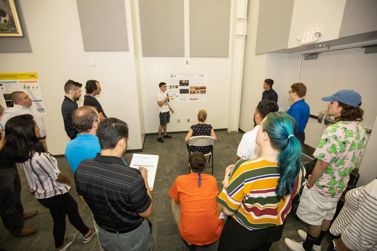
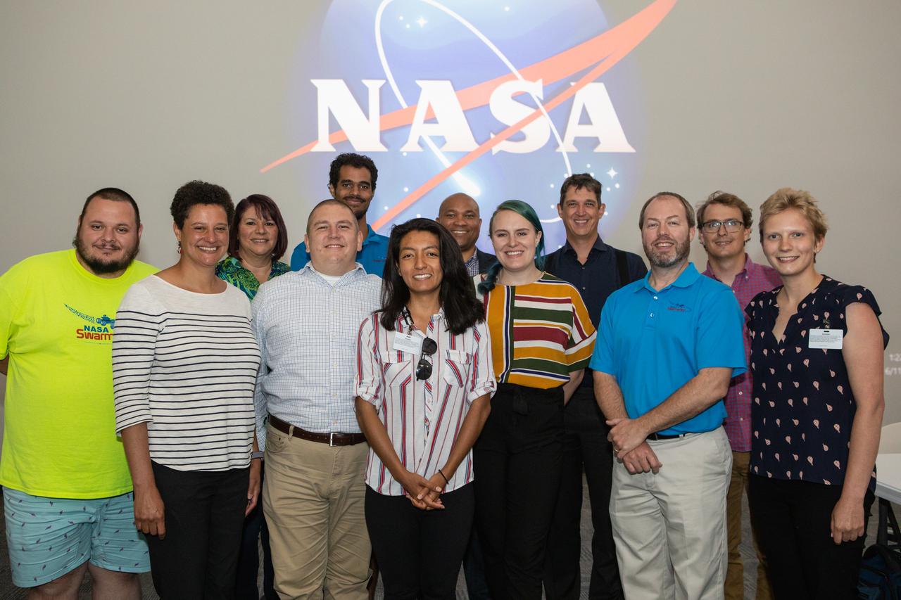
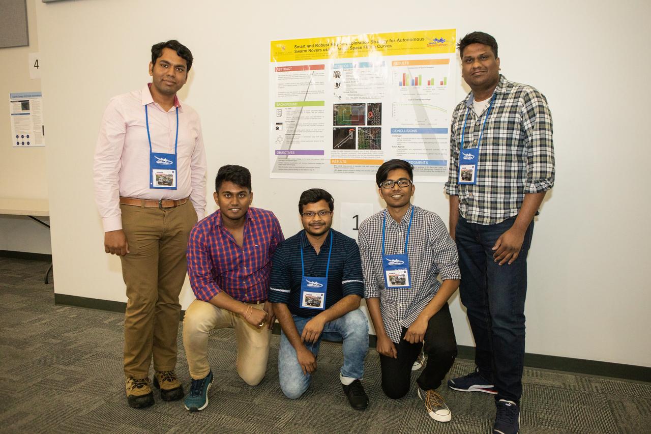
A Swarmathon University Competition 2019 team presents their poster to a panel of judges at the Kennedy Space Center Visitor Complex in Florida on June 11, 2019. Swarmathon students and their mentors were at Kennedy to participate in a student/mentor panel, hear from speakers, get a behind-the-scenes tour of Kennedy Space Center, dine with an astronaut and receive awards during an awards ceremony. During Swarmathon University Challenge IV, students developed algorithms for robotic swarms that are robust and adaptable like the foraging strategies of ant colonies. The fourth and final Swarmathon was a combined virtual and physical competition, hosted by UNM.
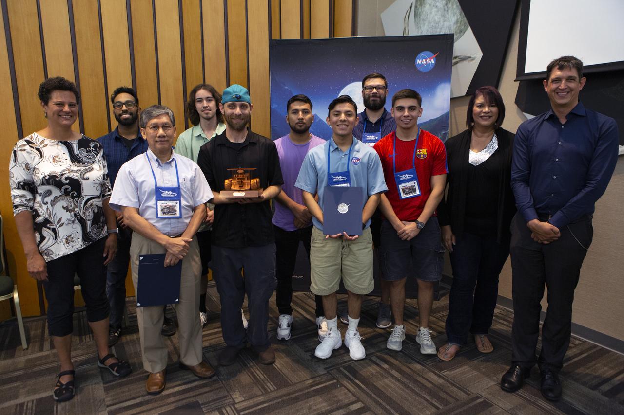
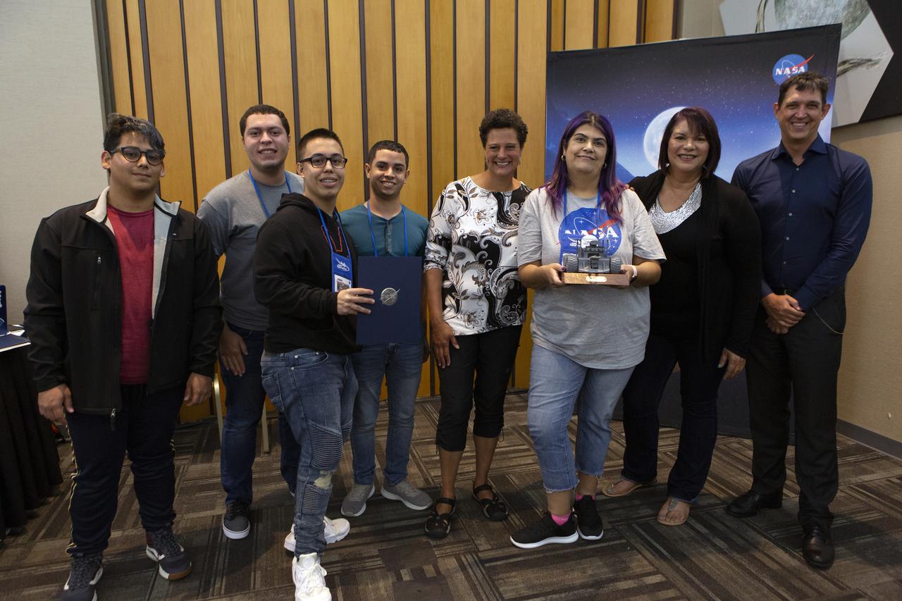
The Swarmathon team from the University of Houston Clearlake and San Jacinto College received the Mission to Mars award for their achievements in the NASA Swarmathon University Challenge for 2019. They are at the Kennedy Space Center Visitor Complex on June 12, 2019. Students and mentors from some of the Swarmathon teams were at Kennedy to participate in a student/mentor panel, hear from speakers, get a behind-the-scenes tour of Kennedy Space Center, dine with an astronaut and receive awards. During Swarmathon University Challenge IV, students developed algorithms for robotic swarms that are robust and adaptable like the foraging strategies of ant colonies. The fourth and final Swarmathon challenge was a combined virtual and physical competition.
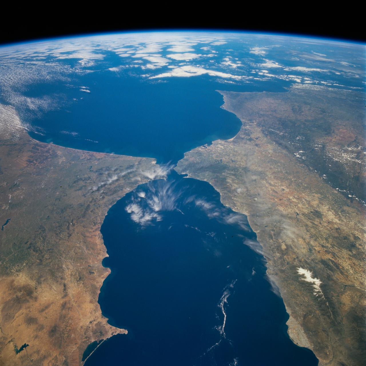
STS077-718-088 (19-29 May 1996) --- A popular photographic target of Space Shuttle astronauts has always been the Strait of Gibraltar seen at center in this wide photograph, shot from the Space Shuttle Endeavour. Spain is to the north (right) and Morocco to the south. The strait is 36 miles (58 kilometers) long and narrows to 8 miles (13 kilometers) at it’s most narrow point. The winds in the strait are either easterly or westerly. The British colony of Gibraltar is the semi-circular feature north of the strait. Gibraltar is considered to be one of the Pillars of Hercules. The white colored area to the southeast of Gibraltar on the Moroccan coast is the city of Tanger (Tangier). The snow covered mountains in Spain are the Sistemas Penibeticos.
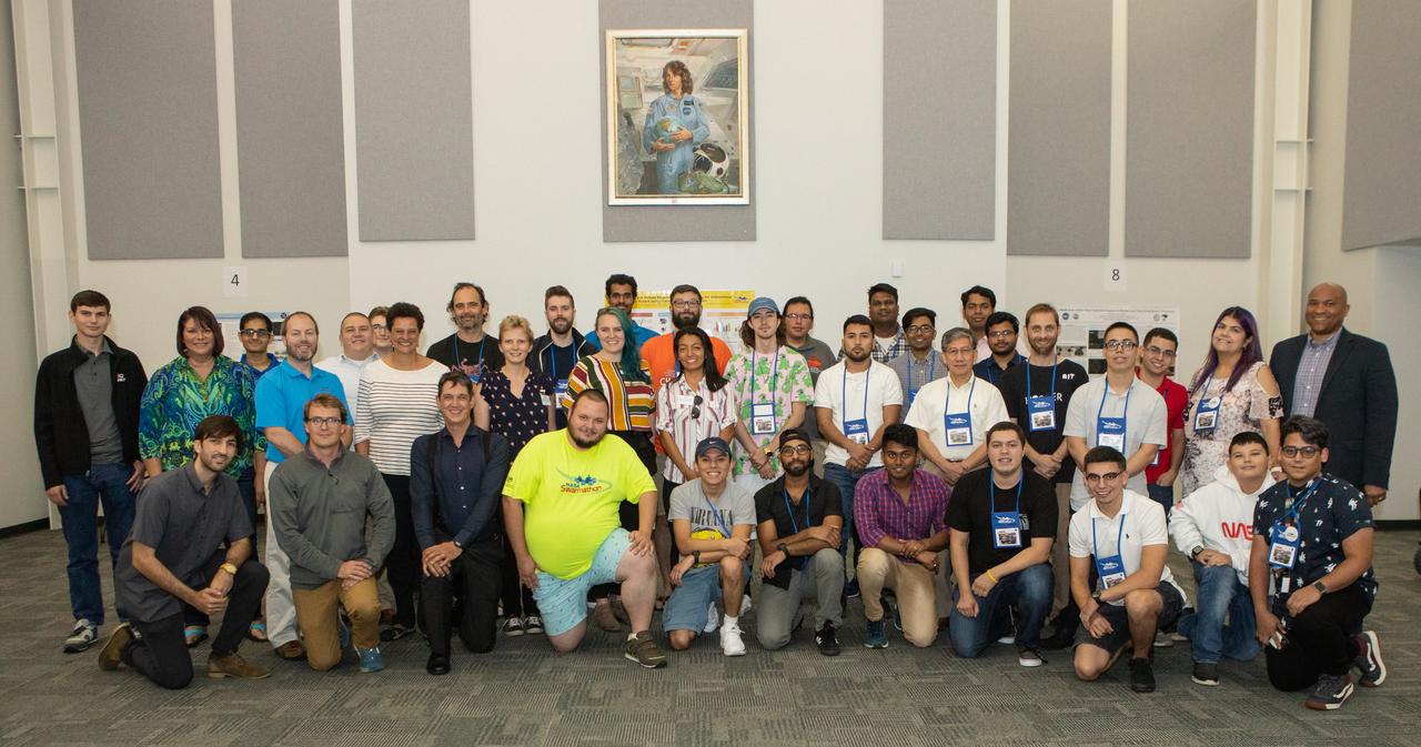
Swarmathon University Competition 2019 organizers, mentors, guest speakers and student teams gather for a group photo on June 11, 2019 at the Kennedy Space Center Visitor Complex in Florida. The University of New Mexico was the host for the physical competition held in May 2019. The student teams were at Kennedy to participate in a student/mentor panel, hear from speakers, get a behind-the-scenes tour of Kennedy Space Center, dine with an astronaut and receive awards during an awards ceremony. During Swarmathon University Challenge IV, students developed algorithms for robotic swarms that are robust and adaptable like the foraging strategies of ant colonies. The fourth and final Swarmathon was a combined virtual and physical competition.
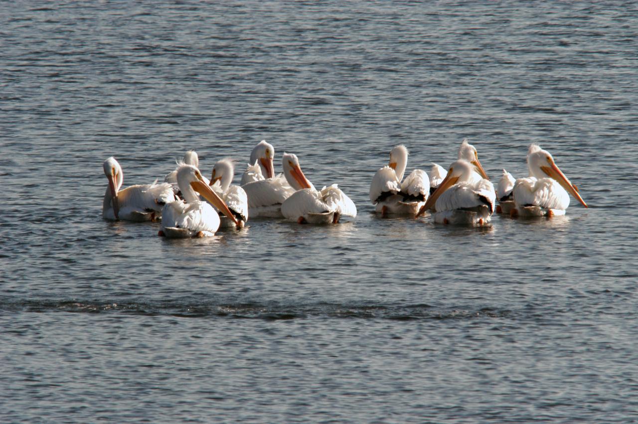
White pelicans gather in the turn basin near the Vehicle Assembly Building of NASA's Kennedy Space Center. The turn basin was carved out of the Banana River when Kennedy Space Center was built. White pelicans winter from Florida and southern California to Panama, chiefly in coastal lagoons, and usually in colonies. KSC shares a boundary with the Merritt Island Wildlife Nature Refuge. The refuge is a habitat for more than 310 species of birds, 25 mammals, 117 fishes and 65 amphibians and reptiles. In addition, the Refuge supports 19 endangered or threatened wildlife species on Federal or State lists, more than any other single refuge in the U.S.
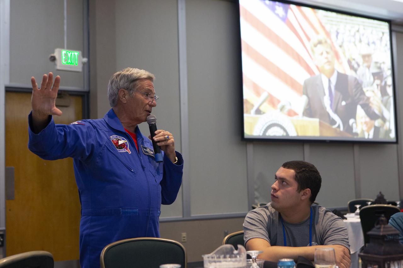
Retired NASA astronaut John Blaha talks to Swarmathon University Challenge students and their mentors during a Dine with an Astronaut event at the Kennedy Space Center Visitor Complex in Florida on June 12, 2019. Students and mentors from some of the Swarmathon teams were at Kennedy to participate in a student/mentor panel, hear from speakers, get a behind-the-scenes tour of Kennedy Space Center, dine with an astronaut and receive awards. For the challenge, university students developed algorithms for robotic swarms that are robust and adaptable like the foraging strategies of ant colonies. The fourth and final Swarmathon challenge was a combined virtual and physical competition hosted by the University of New Mexico.
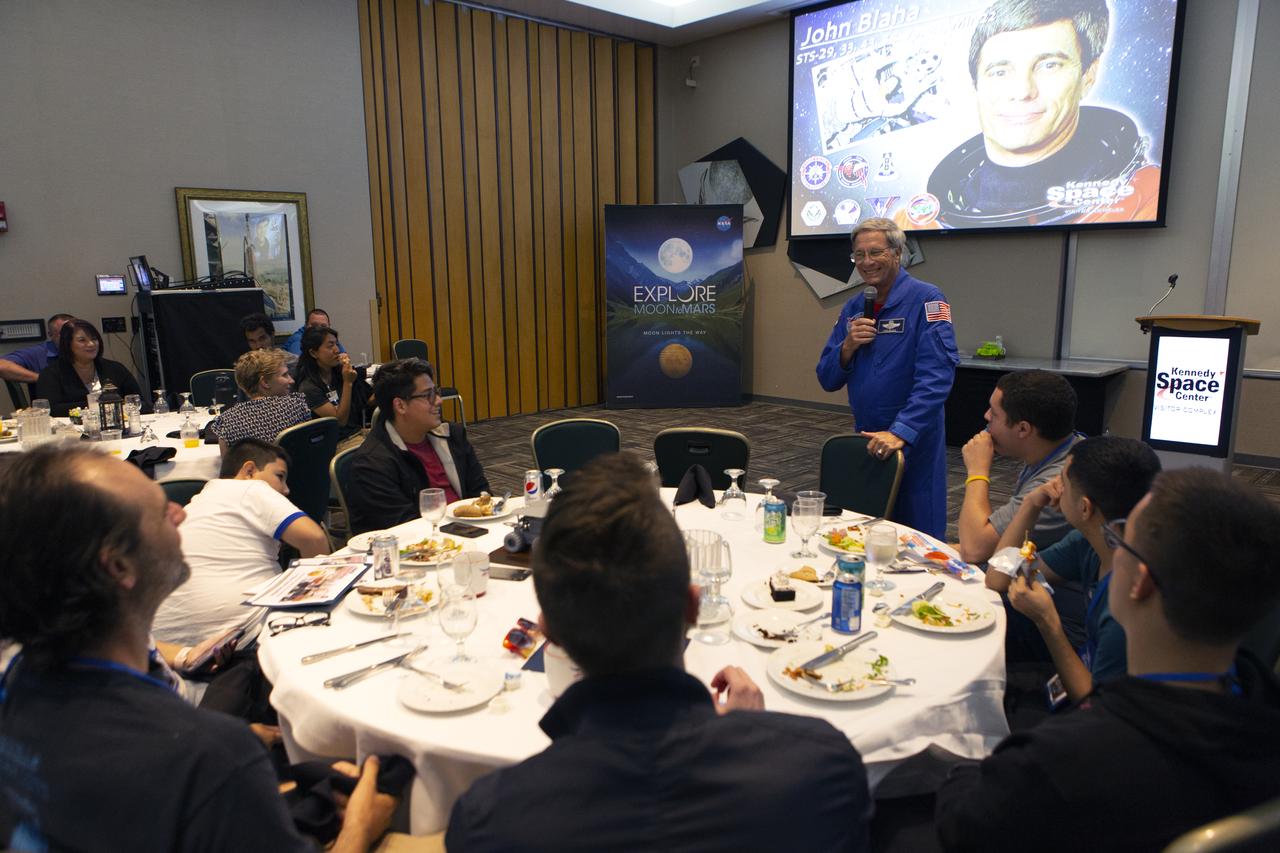
Retired NASA astronaut John Blaha talks to Swarmathon University Challenge students and their mentors during a Dine with an Astronaut event at the Kennedy Space Center Visitor Complex in Florida on June 12, 2019. Students and mentors from some of the Swarmathon teams were at Kennedy to participate in a student/mentor panel, hear from speakers, get a behind-the-scenes tour of Kennedy Space Center, dine with an astronaut and receive awards. For the challenge, university students developed algorithms for robotic swarms that are robust and adaptable like the foraging strategies of ant colonies. The fourth and final Swarmathon challenge was a combined virtual and physical competition hosted by the University of New Mexico.
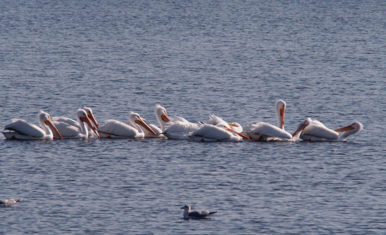
White pelicans form a line while swimming in the turn basin near the Vehicle Assembly Building of NASA's Kennedy Space Center. The turn basin was carved out of the Banana River when Kennedy Space Center was built. White pelicans winter from Florida and southern California to Panama, chiefly in coastal lagoons, and usually in colonies. KSC shares a boundary with the Merritt Island Wildlife Nature Refuge. The refuge is a habitat for more than 310 species of birds, 25 mammals, 117 fishes and 65 amphibians and reptiles. In addition, the Refuge supports 19 endangered or threatened wildlife species on Federal or State lists, more than any other single refuge in the U.S.

A pair of brown pelicans rest on a wall near the turn basin at NASA's Kennedy Space Center. The turn basin was carved out of the Banana River when KSC was built. The birds' habitat is sandy coastal beaches and lagoons, ranging along the Atlantic Coast from North Carolina south to Venezuela. It nests in colonies. KSC shares a boundary with the Merritt Island Wildlife Nature Refuge. The refuge is a habitat for more than 310 species of birds, 25 mammals, 117 fishes and 65 amphibians and reptiles. In addition, the Refuge supports 19 endangered or threatened wildlife species on Federal or State lists, more than any other single refuge in the U.S.

jsc2026e034367 (April 28, 2026) --- Image of Staphylococcus colonies grown on agar in preparation for ground testing as part of ODYSSEY, an investigation that evaluates biofilm formation and exchange of genetic material among two species of bacteria in spaceflight and in simulated microgravity chambers on the ground. Comparing the results between these sample groups could help researchers determine whether Earth-based simulators can be considered as proxies for spaceflight research and get a better understanding of the mechanisms behind biofilm formation and exchange of genetic material when exposed to space-like conditions. Credit: JPL-Caltech.
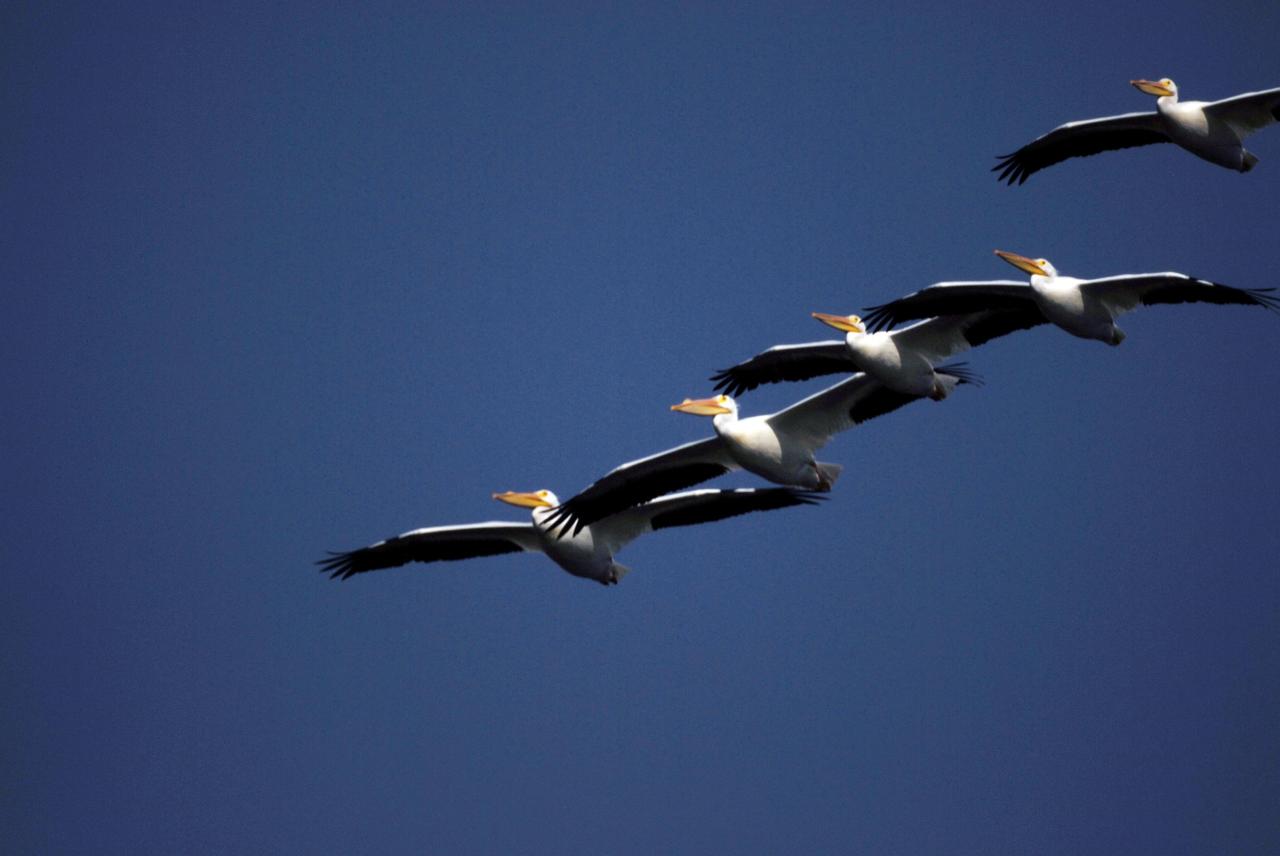
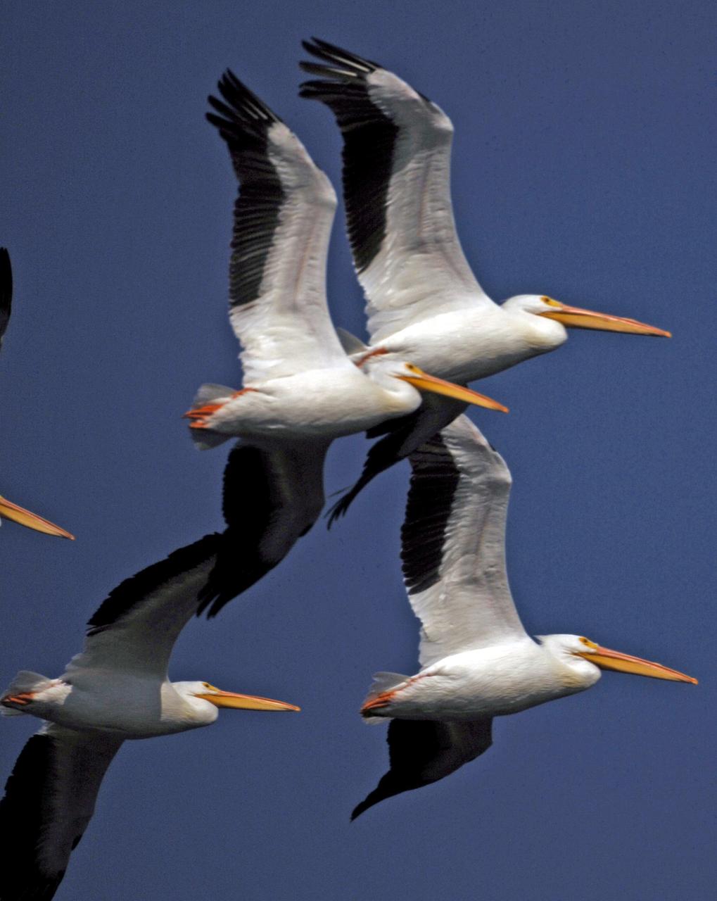
KENNEDY SPACE CENTER, FLA. -- In formation, a flock of white pelicans cruise through the blue sky over NASA's Kennedy Space Center. White pelicans winter from Florida and southern California to Panama, chiefly in coastal lagoons, and usually in colonies. The turn basin was carved out of the Banana River when Kennedy Space Center was built. KSC shares a boundary with the Merritt Island National Wildlife Refuge. The refuge is a habitat for more than 310 species of birds, 25 mammals, 117 fishes and 65 amphibians and reptiles. In addition, the refuge supports 19 endangered or threatened wildlife species on Federal or State lists, more than any other single refuge in the U.S. Photo credit: NASA/Ken Thornsley
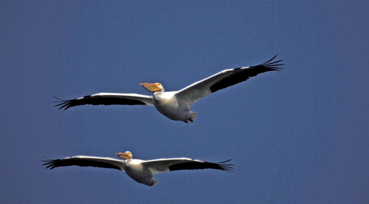
KENNEDY SPACE CENTER, FLA. -- White pelicans cruise through the blue sky over NASA's Kennedy Space Center. White pelicans winter from Florida and southern California to Panama, chiefly in coastal lagoons, and usually in colonies. The turn basin was carved out of the Banana River when Kennedy Space Center was built. KSC shares a boundary with the Merritt Island National Wildlife Refuge. The refuge is a habitat for more than 310 species of birds, 25 mammals, 117 fishes and 65 amphibians and reptiles. In addition, the refuge supports 19 endangered or threatened wildlife species on Federal or State lists, more than any other single refuge in the U.S. Photo credit: NASA/Ken Thornsley
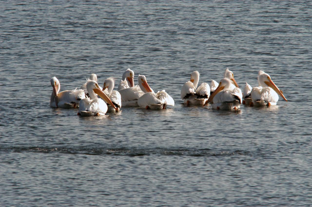
KENNEDY SPACE CENTER, FLA. -- White pelicans gather in the turn basin near the Vehicle Assembly Building of NASA's Kennedy Space Center. The turn basin was carved out of the Banana River when Kennedy Space Center was built. White pelicans winter from Florida and southern California to Panama, chiefly in coastal lagoons, and usually in colonies. KSC shares a boundary with the Merritt Island Wildlife Nature Refuge. The refuge is a habitat for more than 310 species of birds, 25 mammals, 117 fishes and 65 amphibians and reptiles. In addition, the Refuge supports 19 endangered or threatened wildlife species on Federal or State lists, more than any other single refuge in the U.S. Photo credit: NASA/George Shelton
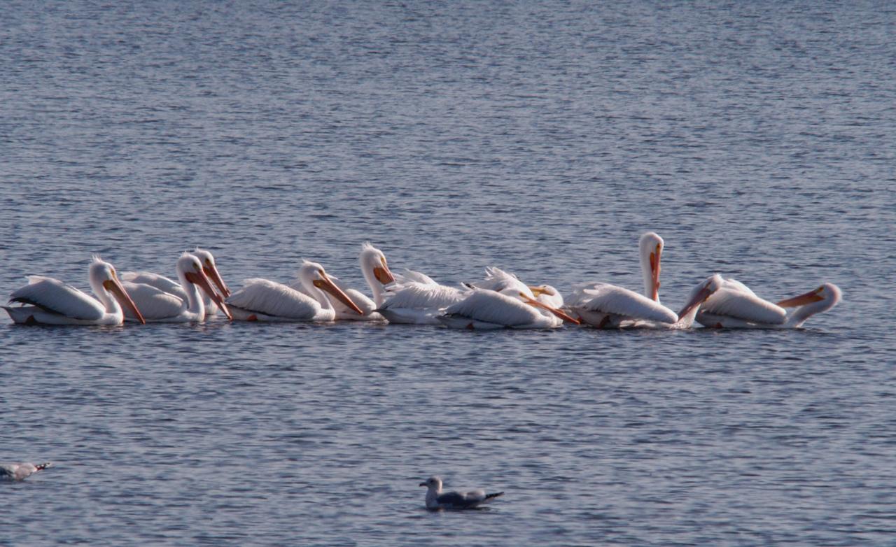
KENNEDY SPACE CENTER, FLA. -- White pelicans form a line while swimming in the turn basin near the Vehicle Assembly Building of NASA's Kennedy Space Center. The turn basin was carved out of the Banana River when Kennedy Space Center was built. White pelicans winter from Florida and southern California to Panama, chiefly in coastal lagoons, and usually in colonies. KSC shares a boundary with the Merritt Island Wildlife Nature Refuge. The refuge is a habitat for more than 310 species of birds, 25 mammals, 117 fishes and 65 amphibians and reptiles. In addition, the Refuge supports 19 endangered or threatened wildlife species on Federal or State lists, more than any other single refuge in the U.S. Photo credit: NASA/George Shelton
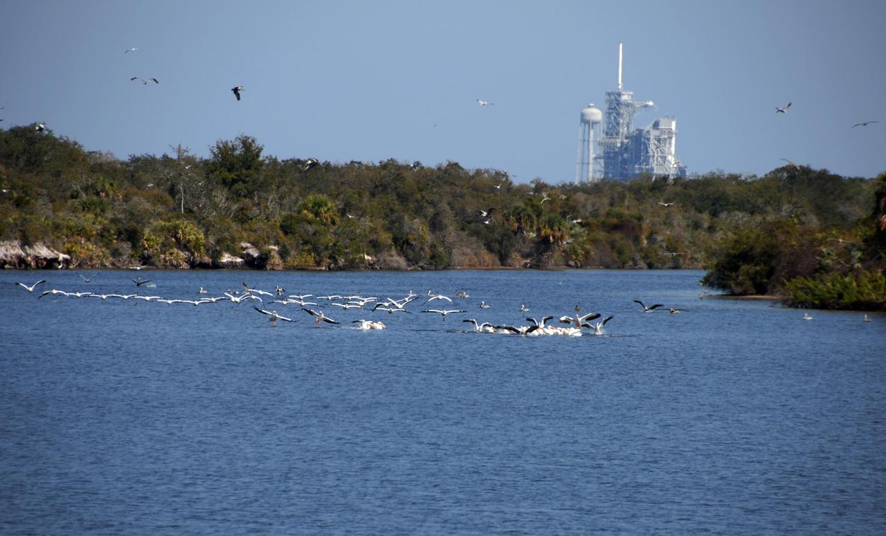
KENNEDY SPACE CENTER, FLA. -- A flock of white pelicans splash down in the turn basin near one of the launch pads at NASA's Kennedy Space Center. White pelicans winter from Florida and southern California to Panama, chiefly in coastal lagoons, and usually in colonies. The turn basin was carved out of the Banana River when Kennedy Space Center was built. KSC shares a boundary with the Merritt Island National Wildlife Refuge. The refuge is a habitat for more than 310 species of birds, 25 mammals, 117 fishes and 65 amphibians and reptiles. In addition, the refuge supports 19 endangered or threatened wildlife species on Federal or State lists, more than any other single refuge in the U.S. Photo credit: NASA/Ken Thornsley
KENNEDY SPACE CENTER, FLA. -- In formation, a flock of white pelicans cruise through the blue sky over NASA's Kennedy Space Center. White pelicans winter from Florida and southern California to Panama, chiefly in coastal lagoons, and usually in colonies. The turn basin was carved out of the Banana River when Kennedy Space Center was built. KSC shares a boundary with the Merritt Island National Wildlife Refuge. The refuge is a habitat for more than 310 species of birds, 25 mammals, 117 fishes and 65 amphibians and reptiles. In addition, the refuge supports 19 endangered or threatened wildlife species on Federal or State lists, more than any other single refuge in the U.S. Photo credit: NASA/Ken Thornsley
The University of New Mexico (UNM) faculty and students who administer the Swarmathon University Competition 2019 gather for a group photo on June 11, 2019 at the Kennedy Space Center Visitor Complex in Florida. Melanie Moses, faculty lead for Swarmathon and a professor of computer science at UNM, is second from left. Behind her is Theresa Martinez, Minority University Research and Education Program (MUREP) Science, Technology, Education and Math (STEM) engagement manager, at Kennedy Space Center. Swarmathon University Competition students and their mentors were at Kennedy to participate in a student/mentor panel, hear from speakers, get a behind-the-scenes tour of Kennedy Space Center, dine with an astronaut and receive awards. During Swarmathon University Challenge IV, students developed algorithms for robotic swarms that are robust and adaptable like the foraging strategies of ant colonies. The fourth and final Swarmathon was a combined virtual and physical competition, hosted by UNM.
During an awards ceremony on June 12, 2019 at the Kennedy Space Center Visitor Complex in Florida, mentors and volunteers from Kennedy received certificates of recognition for the NASA Swarmathon 2019 University Challenge. Second from right is Melanie Moses, a professor of computer science at the Swarmathon host location, University of New Mexico. At far right is Theresa Martinez, engagement manager of the Minority University Research and Education Program, managed at Kennedy. University students and their mentors were at Kennedy to participate in a student/mentor panel, hear from speakers, get a behind-the-scenes tour of Kennedy Space Center, dine with an astronaut and receive awards. During Swarmathon University Challenge IV, students developed algorithms for robotic swarms that are robust and adaptable like the foraging strategies of ant colonies. The fourth and final Swarmathon was a combined virtual and physical competition.
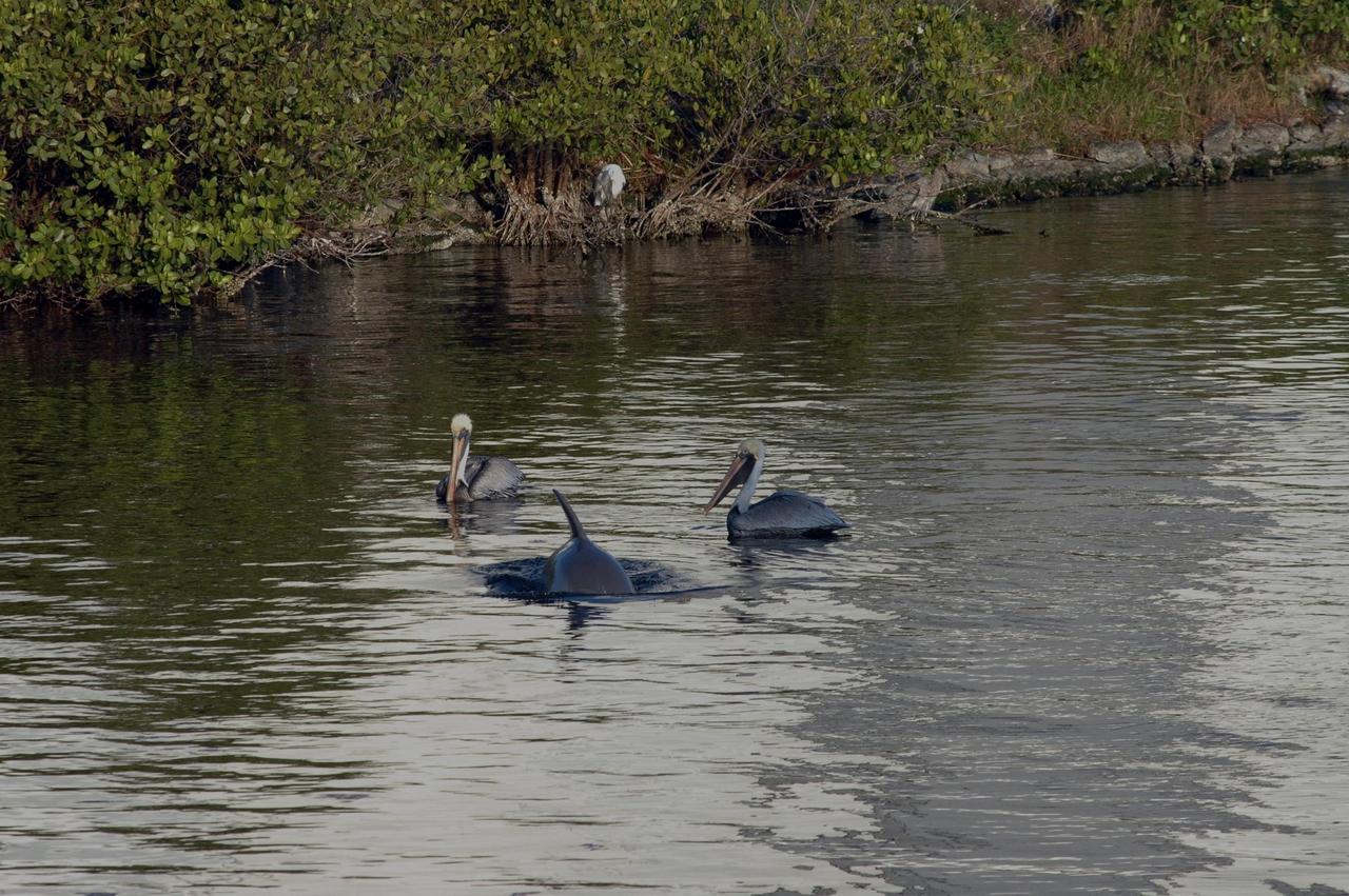
KENNEDY SPACE CENTER, FLA. -- In the turn basin near the Vehicle Assembly Building, a dolphin interrupts two white pelicans swimming near the shore. White pelicans winter from Florida and southern California to Panama, chiefly in coastal lagoons, and usually in colonies. The turn basin was carved out of the Banana River when Kennedy Space Center was built. KSC shares a boundary with the Merritt Island Wildlife Nature Refuge. The refuge is a habitat for more than 310 species of birds, 25 mammals, 117 fishes and 65 amphibians and reptiles. In addition, the Refuge supports 19 endangered or threatened wildlife species on Federal or State lists, more than any other single refuge in the U.S. Photo credit: NASA/Jim Grossmann
The Swarmathon University Competition 2019 team members from the University of Maryland participate in activities at the Kennedy Space Center Visitor Complex in Florida on June 11, 2019. They are standing in front of a poster they created for the poster competition portion of Swarmathon. The University of New Mexico was the host for the physical competition held in May 2019. The student teams were at Kennedy to participate in a student/mentor panel, hear from speakers, get a behind-the-scenes tour of Kennedy Space Center, dine with an astronaut and receive awards during an awards ceremony. During Swarmathon University Challenge IV, students developed algorithms for robotic swarms that are robust and adaptable like the foraging strategies of ant colonies. The fourth and final Swarmathon was a combined virtual and physical competition.
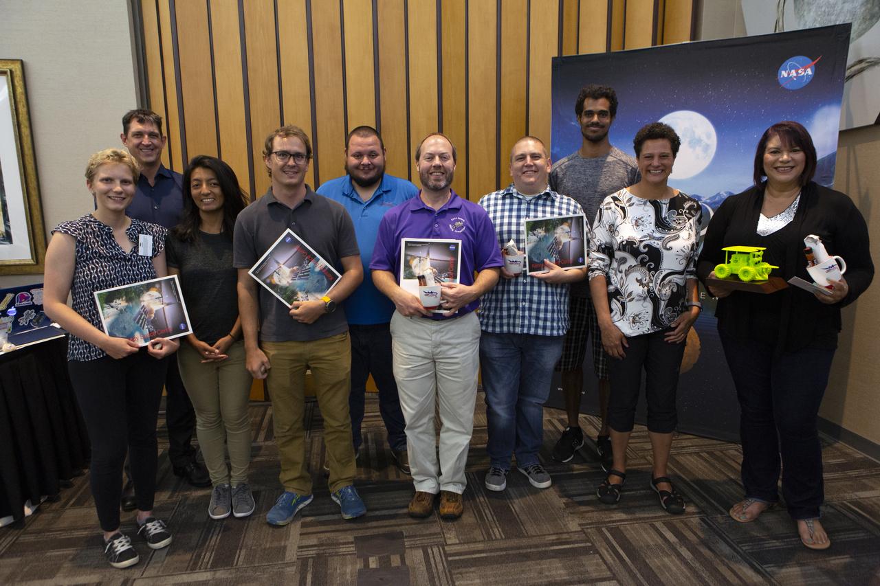
The Swarmathon team from the University of Puerto Rico at Arecibo received the Best Poster Award during the awards ceremony for NASA’s Swarmathon University Challenge IV, at the Kennedy Space Center Visitor Complex in Florida on June 12, 2019. Students and mentors from some of the Swarmathon teams were at Kennedy to participate in a student/mentor panel, hear from speakers, get a behind-the-scenes tour of Kennedy Space Center, dine with an astronaut and receive awards. For the challenge, university students developed algorithms for robotic swarms that are robust and adaptable like the foraging strategies of ant colonies. The fourth and final Swarmathon challenge was a combined virtual and physical competition. Fourth from right is Melanie Moses, a professor of computer science at the University of New Mexico, the host location for Swarmathon. Second from right is Theresa Martinez, engagement manager of the Minority University Research and Education Program, managed at Kennedy.
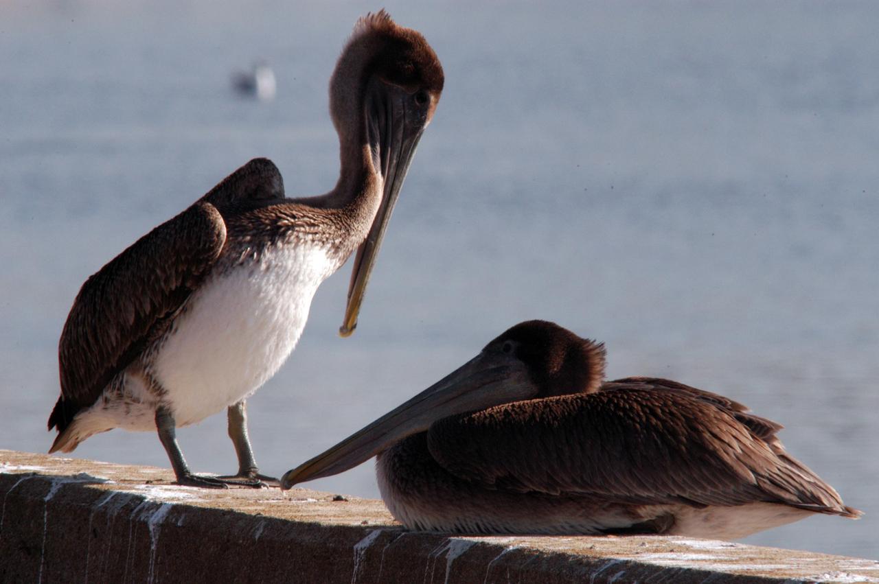
KENNEDY SPACE CENTER, FLA. -- A pair of brown pelicans rest on a wall near the turn basin at NASA's Kennedy Space Center. The turn basin was carved out of the Banana River when KSC was built. The birds' habitat is sandy coastal beaches and lagoons, ranging along the Atlantic Coast from North Carolina south to Venezuela. It nests in colonies. KSC shares a boundary with the Merritt Island Wildlife Nature Refuge. The refuge is a habitat for more than 310 species of birds, 25 mammals, 117 fishes and 65 amphibians and reptiles. In addition, the Refuge supports 19 endangered or threatened wildlife species on Federal or State lists, more than any other single refuge in the U.S. Photo credit: NASA/George Shelton
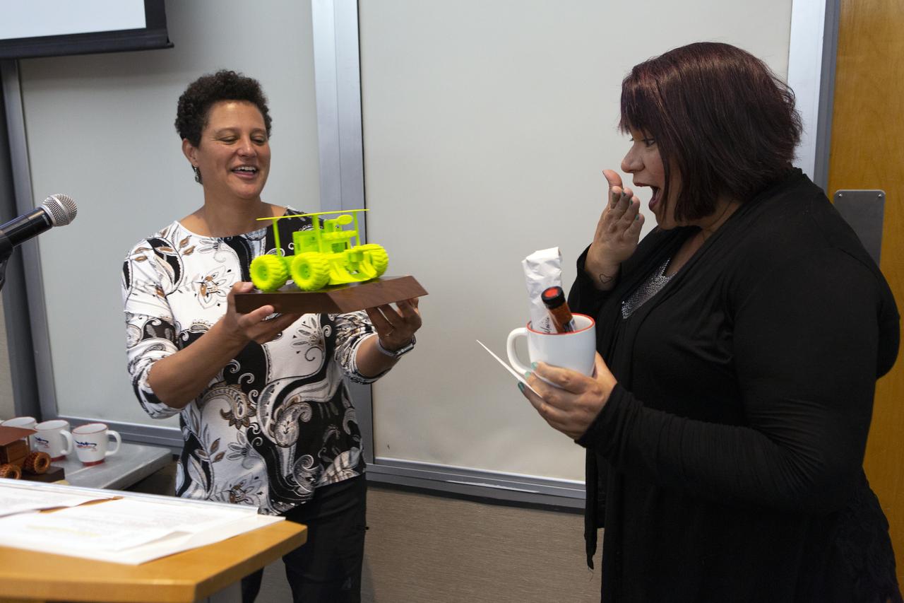
Melanie Moses, a professor of computer science at the University of New Mexico, presents a small replica of a Swarmie robot to Theresa Martinez, engagement manager of the Minority University Research and Education Program, during an awards ceremony at the Kennedy Space Center Visitor Complex in Florida on June 12, 2019. Swarmathon University Competition students and their mentors were at Kennedy to participate in a student/mentor panel, hear from speakers, get a behind-the-scenes tour of Kennedy Space Center, dine with an astronaut and receive awards. During Swarmathon University Challenge IV, students developed algorithms for robotic swarms that are robust and adaptable like the foraging strategies of ant colonies. The fourth and final Swarmathon was a combined virtual and physical competition, hosted by the University of New Mexico.
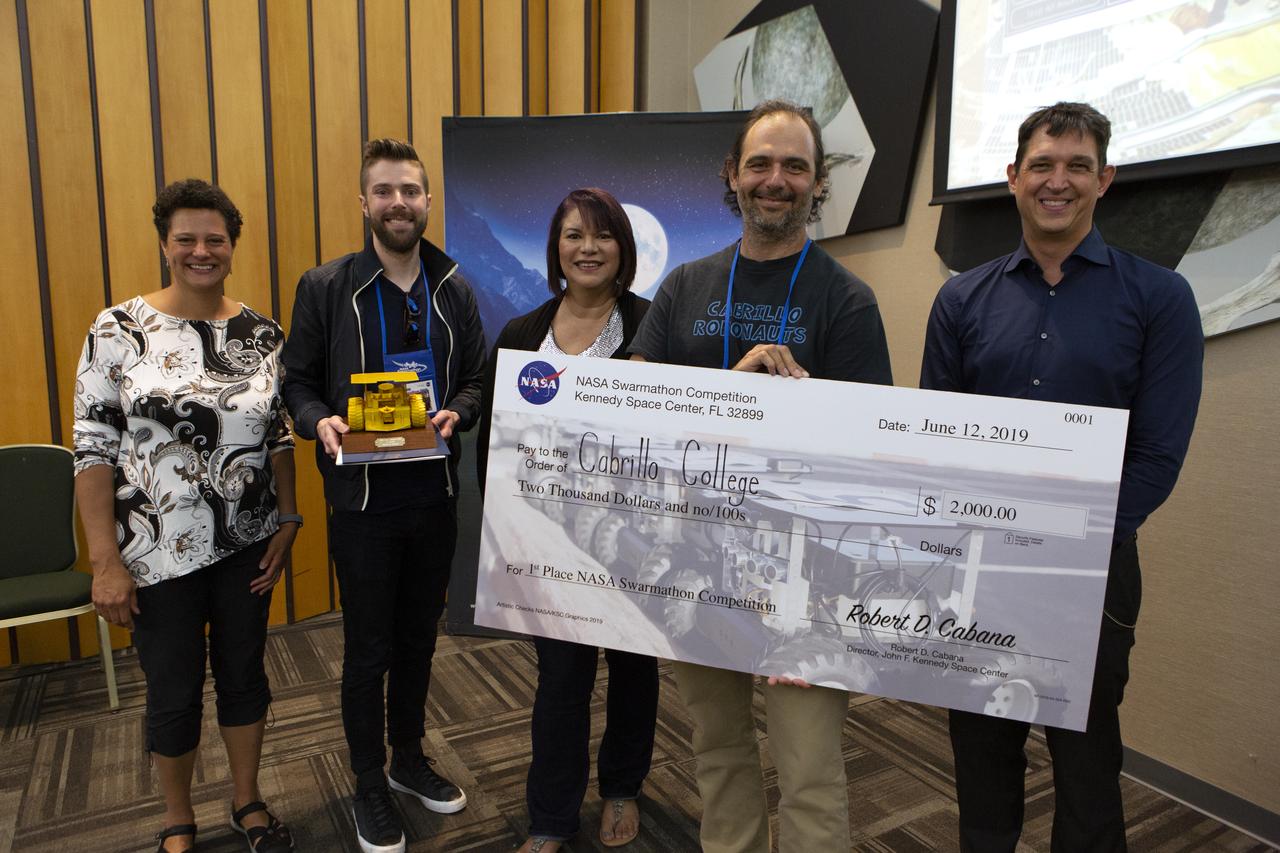
The Swarmathon team from Cabrillo College received first place in NASA’s Swarmathon University Challenge IV, during a ceremony at the Kennedy Space Center Visitor Complex in Florida on June 12, 2019. Students and mentors from some of the Swarmathon teams were at Kennedy to participate in a student/mentor panel, hear from speakers, get a behind-the-scenes tour of Kennedy Space Center, dine with an astronaut and receive awards. For the challenge, university students developed algorithms for robotic swarms that are robust and adaptable like the foraging strategies of ant colonies. The fourth and final Swarmathon challenge was a combined virtual and physical competition. At far right is Melanie Moses, a professor of computer science at the University of New Mexico, the host location for Swarmathon. Third from left is Theresa Martinez, engagement manager of the Minority University Research and Education Program, managed at Kennedy.
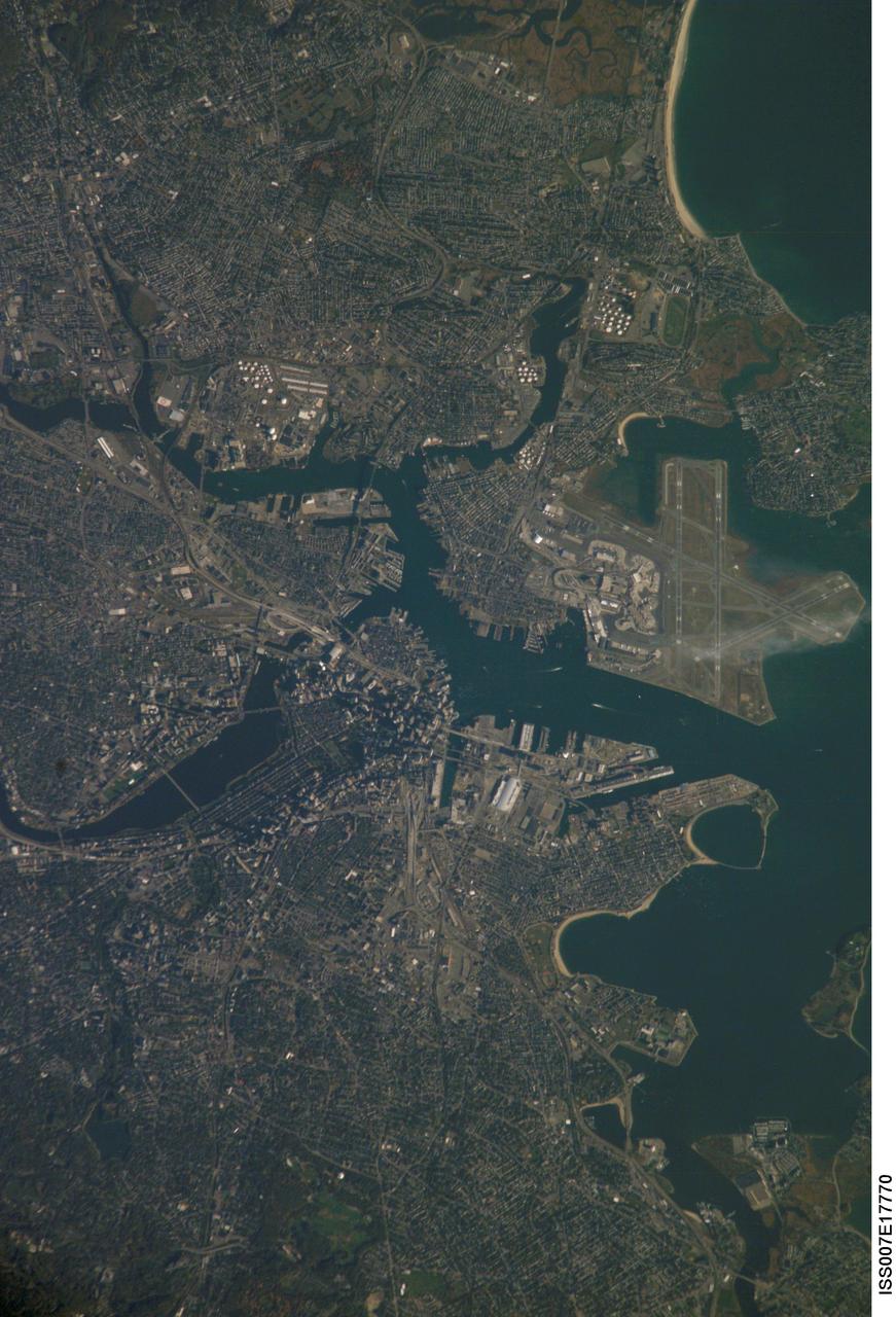
ISS007-E-17770 (20 October 2003) --- Boston, Massachusetts was featured in this image taken by one of the Expedition 7 crewmembers onboard the International Space Station (ISS). The image provides a good view of the center of the city, including famous colonial and independence locations extending from Boston Common to the North End. Wispy clouds hover over the south end of Logan Airport. Ship traffic in the Charles and Mystic Rivers is marked by wakes of the ships. And highly reflective construction locations, including the new I-93 and the bridge over the Charles River, and highway exchanges at Logan Airport mark the new elements of Boston's Big Dig, which is the local transportation project that is now believed to be the largest civil engineering endeavor in U.S. history.

CAPE CANAVERAL, Fla. - A colony of brown pelicans takes advantage of a respite from winter temperatures to sun themselves along the edges of the Turn Basin in Launch Complex 39 at NASA's Kennedy Space Center in Florida. The brown pelican is found along the coast in California and from North Carolina to Texas, Mexico, the West Indies and many Caribbean Islands, as well as Guyana and Venezuela in South America. It is listed as endangered only in Louisiana, Mississippi, and in the Caribbean. The species is considered to be long-lived. One pelican captured in Edgewater, Fla., in November 1964, was found to have been banded in September 1933, over 31 years previously. Individuals can weigh up to eight pounds, with larger pelicans having wing spreads of over seven feet. Their nests are usually built in mangrove trees, but ground nesting may also occur. Nesting takes place mostly in early spring or summer with the male carrying nesting materials to the female. Although the female builds the nest, both share in incubation and rearing duties. The Merritt Island National Wildlife Refuge coexists with Kennedy Space Center and provides a habitat for 330 species of birds including brown pelicans. Photo credit: NASA/Jack Pfaller
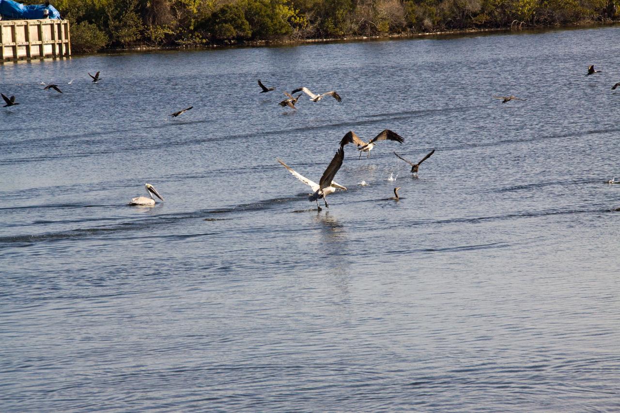
CAPE CANAVERAL, Fla. - A colony of brown pelicans enjoys a respite from the winter temperatures with a dip in the Turn Basin in Launch Complex 39 at NASA's Kennedy Space Center in Florida. The brown pelican is found along the coast in California and from North Carolina to Texas, Mexico, the West Indies and many Caribbean Islands, as well as Guyana and Venezuela in South America. It is listed as endangered only in Louisiana, Mississippi, and in the Caribbean. The species is considered to be long-lived. One pelican captured in Edgewater, Fla., in November 1964, was found to have been banded in September 1933, over 31 years previously. Individuals can weigh up to eight pounds, with larger pelicans having wing spreads of over seven feet. Their nests are usually built in mangrove trees, but ground nesting may also occur. Nesting takes place mostly in early spring or summer with the male carrying nesting materials to the female. Although the female builds the nest, both share in incubation and rearing duties. The Merritt Island National Wildlife Refuge coexists with Kennedy Space Center and provides a habitat for 330 species of birds including brown pelicans. Photo credit: NASA/Jack Pfaller
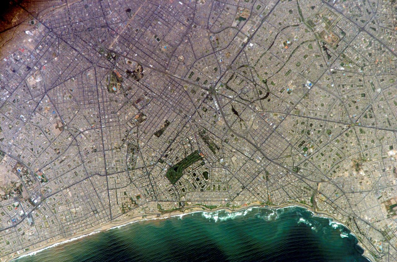
ISS010-E-20111 (15 March 2005) --- Lima, Peru is featured in this image photographed by an Expedition 10 crewmember on the International Space Station (ISS). Located on the broad alluvial fan of the Rimac River, Lima is the capital of Peru and the only mega city (7.7 million inhabitants in 2002) located on the western coastline of South America. The city was established by Francisco Pizarro in 1535 and became an important colonial port linking silver mines of the Altiplano of the high Andes to the east with the burgeoning Spanish empire. During the mid-20th century a significant relocation of people from rural mountain communities into the Lima metropolitan area led to its growth into a mega city. Problems now facing the metropolitan region include development of adequate water resources, control of pollution, and the potential effects of natural hazards such as earthquakes and landslides. This photograph depicts the wealthier San Isidro and Mira Flores quarters of Lima. This part of the metropolitan area is characterized by numerous vegetated parks, golf courses (such as the Lima Golf Course—approximately 1 kilometer long), and greenbelts interspersed with residential and commercial areas. The higher proportion of dark asphalt in the street grid of the residential and commercial areas lends a purple coloration to the left portion of the image (downtown Lima is to the north). Regions with fewer built materials and vegetation are light tan. Wave patterns are visible approaching beaches, popular tourist destinations, in the lower half of the image.
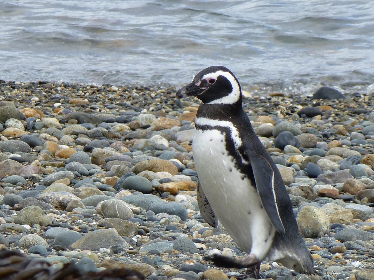
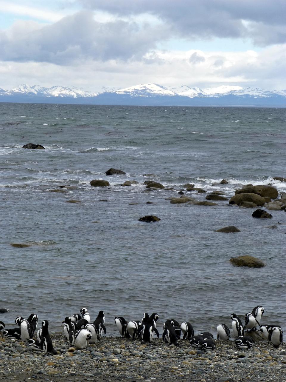
Members of the IceBridge team visited a colony of Magellanic penguins near Punta Arenas on a no-flight day. Credit: NASA/ Maria-Jose Vinas NASA's Operation IceBridge is an airborne science mission to study Earth's polar ice. For more information about IceBridge, visit: <a href="http://www.nasa.gov/icebridge" rel="nofollow">www.nasa.gov/icebridge</a> <b><a href="http://www.nasa.gov/audience/formedia/features/MP_Photo_Guidelines.html" rel="nofollow">NASA image use policy.</a></b> <b><a href="http://www.nasa.gov/centers/goddard/home/index.html" rel="nofollow">NASA Goddard Space Flight Center</a></b> enables NASA’s mission through four scientific endeavors: Earth Science, Heliophysics, Solar System Exploration, and Astrophysics. Goddard plays a leading role in NASA’s accomplishments by contributing compelling scientific knowledge to advance the Agency’s mission. <b>Follow us on <a href="http://twitter.com/NASA_GoddardPix" rel="nofollow">Twitter</a></b> <b>Like us on <a href="http://www.facebook.com/pages/Greenbelt-MD/NASA-Goddard/395013845897?ref=tsd" rel="nofollow">Facebook</a></b> <b>Find us on <a href="http://instagrid.me/nasagoddard/?vm=grid" rel="nofollow">Instagram</a></b>
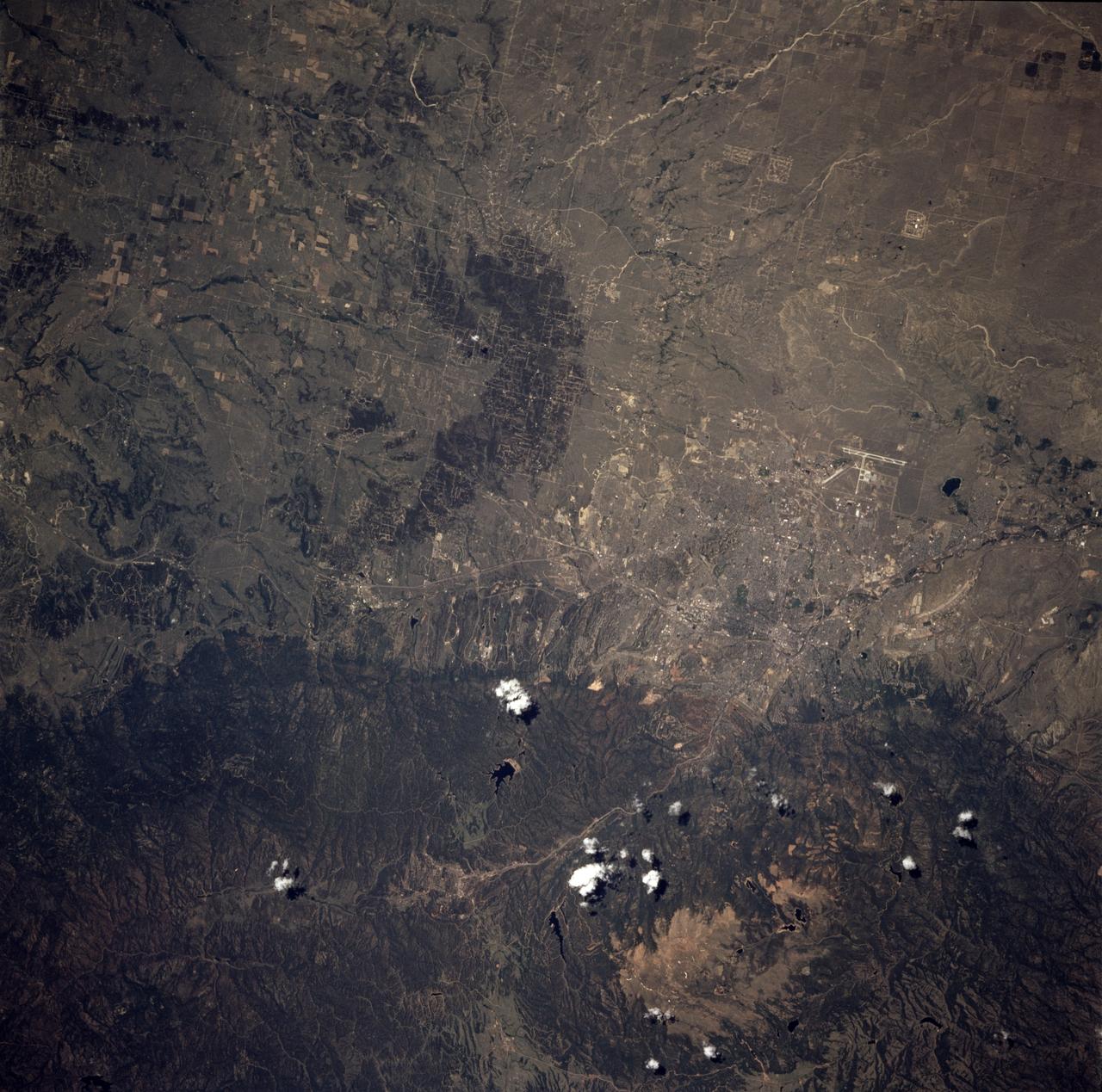
STS078-736-064 (20 June - 7 July 1996) --- As photographed by the flight crew of the Space Shuttle Columbia in Earth-orbit, the city of Colorado Springs, Colorado, is seen near the eastern base of Pikes Peak. It was built on a mesa at 6,008 feet (1,831 meters) sea level. Pikes Peak is the large tan patch on the bottom left or west portion of the photo. The city is the headquarters of Pike National Forest, located on its west side. Founded in 1871 as Fountain Colony by General William J. Palmer, builder of the Denver and Rio Grande Western Railroad, it was renamed for the nearby Manitou mineral springs. Growth of the area followed the Cripple Creek gold strikes in the 1890s and the promotion of the tourist-health-resort trade in the area. The establishment of military installations gave further impetus to development. The North American Air Defense and Aerospace Defense commands are headquartered at Peterson Air Force Base (Peterson Field). Fort Carson (1942), on the city's southern edge, is the home of the Fourth United States Infantry Division. The United States Air Force Academy (1954), just to the north, is set against a backdrop of the Rampart Range. Its population in 1990 was 281,140.
Members of the IceBridge team visited a colony of Magellanic penguins near Punta Arenas on a no-flight day. Credit: NASA/ Maria-Jose Vinas NASA's Operation IceBridge is an airborne science mission to study Earth's polar ice. For more information about IceBridge, visit: <a href="http://www.nasa.gov/icebridge" rel="nofollow">www.nasa.gov/icebridge</a> <b><a href="http://www.nasa.gov/audience/formedia/features/MP_Photo_Guidelines.html" rel="nofollow">NASA image use policy.</a></b> <b><a href="http://www.nasa.gov/centers/goddard/home/index.html" rel="nofollow">NASA Goddard Space Flight Center</a></b> enables NASA’s mission through four scientific endeavors: Earth Science, Heliophysics, Solar System Exploration, and Astrophysics. Goddard plays a leading role in NASA’s accomplishments by contributing compelling scientific knowledge to advance the Agency’s mission. <b>Follow us on <a href="http://twitter.com/NASA_GoddardPix" rel="nofollow">Twitter</a></b> <b>Like us on <a href="http://www.facebook.com/pages/Greenbelt-MD/NASA-Goddard/395013845897?ref=tsd" rel="nofollow">Facebook</a></b> <b>Find us on <a href="http://instagrid.me/nasagoddard/?vm=grid" rel="nofollow">Instagram</a></b>
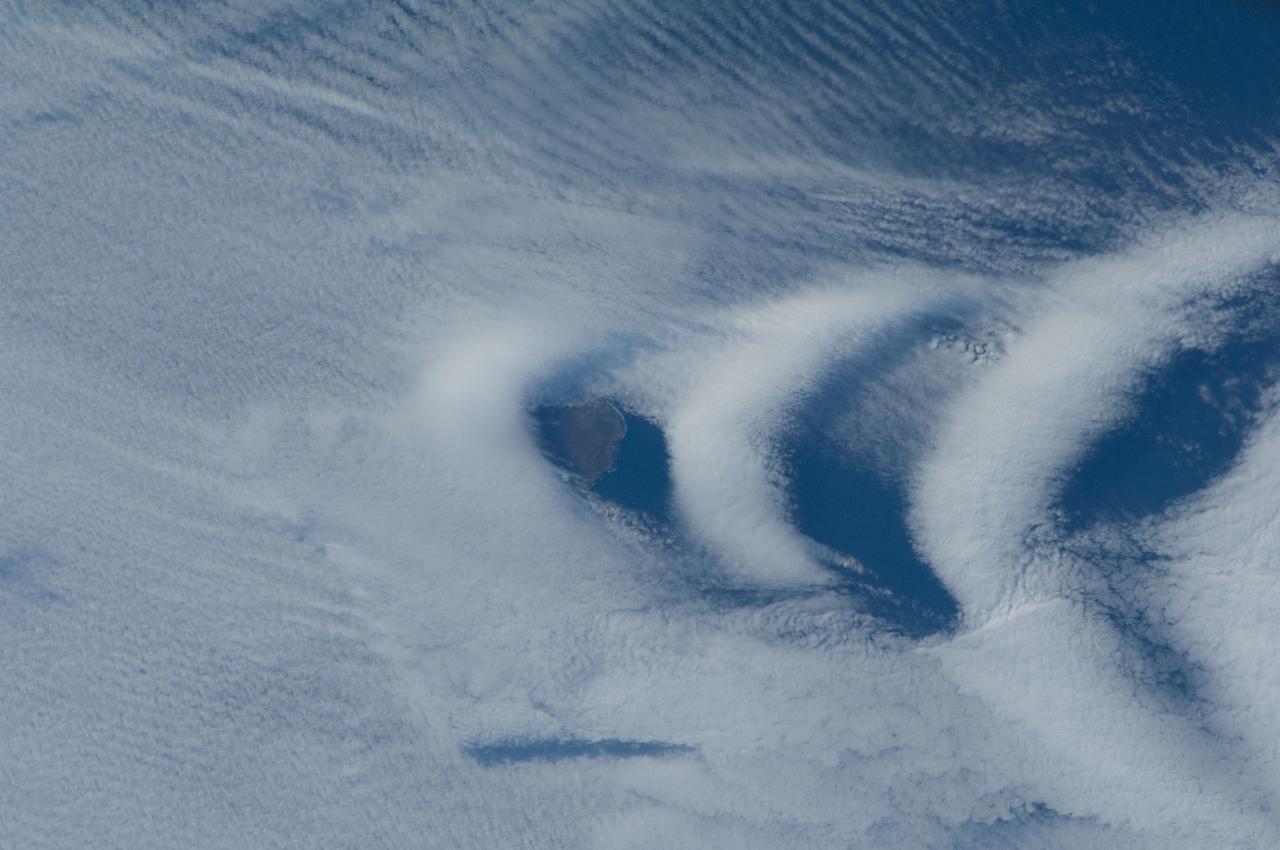
ISS030-E-193144 (25 March 2012) --- Wave clouds near Ile aux Cochons are featured in this image photographed by an Expedition 30 crew member on the International Space Station. This photograph illustrates the formation of wave clouds in the wake—or downwind side—of Ile aux Cochons (“Isle of Pigs”) located in the Southern Indian Ocean. The island is approximately located 3,000 kilometers southeast of the southern tip of the African continent and 2,300 kilometers northwest of Antarctica. The island itself, of which only a part of the eastern coastline is visible at center, is volcanic in origin with a summit elevation of 775 meters above sea level. According to scientists, the Ile aux Cochons stratovolcano is thought to have erupted within the last 12,000 years; however no historical activity has been recorded. The summit elevation is high enough for the land surface to interact with cloud layers and winds flowing past the island. Two major cloud layers are visible; a lower, more uniform layer consists of roughly parallel cloud “streets” that suggest a westerly flow pattern of air. When the air mass encounters the Ile aux Cochons, moisture-laden air rises and cools, causing more water vapor to condense into clouds. As the air mass passes over the summit of Ile aux Cochons and descends, it may encounter alternating moist and dry air layers, enabling the formation of the discontinuous chevron-shaped wave clouds in the wake of the island. While their appearance suggests that the clouds are forming in the wake of the island and moving eastwards, in fact it is the air mass that is moving, with clouds forming in regions of moist air and dissipating in dry regions. Ile aux Cochons is the westernmost of the islands that form the subantarctic Crozet Archipelago (part of the French Southern and Antarctic Lands). Accept for occasional research visits, the island is uninhabited. The island is an important breeding site for seabirds, including the world’s largest King Penguin colony.
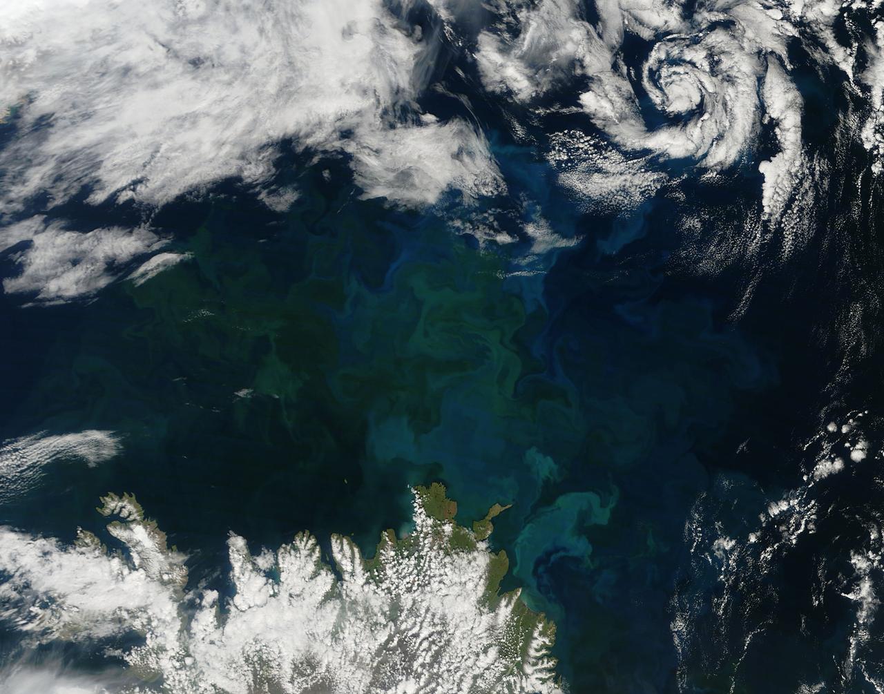
A massive phytoplankton bloom stained the waters of the Atlantic Ocean north of Iceland with brilliant jewel tones in late summer, 2014. The Moderate Resolution Imaging Spectroradiometer (MODIS) aboard NASA’s Aqua satellite captured this true-color image on August 2. Huge colonies of the floating, plant-like organisms create swirls of green, teal and turquoise and cover over 80% of the visible ocean off the northeast coast of Iceland. Marine phytoplankton require just the right amount of sunlight, dissolved nutrients and water temperatures which are not too hot, nor too cold to spark explosive reproduction and result in blooms which can cover hundreds of square kilometers. Phytoplankton form the base of the marine food chain, and are a rich food source for zooplankton, fish and other marine species. Some species, however, can deplete the water of oxygen and may become toxic to marine life. Credit: NASA/GSFC/Jeff Schmaltz/MODIS Land Rapid Response Team <b><a href="http://www.nasa.gov/audience/formedia/features/MP_Photo_Guidelines.html" rel="nofollow">NASA image use policy.</a></b> <b><a href="http://www.nasa.gov/centers/goddard/home/index.html" rel="nofollow">NASA Goddard Space Flight Center</a></b> enables NASA’s mission through four scientific endeavors: Earth Science, Heliophysics, Solar System Exploration, and Astrophysics. Goddard plays a leading role in NASA’s accomplishments by contributing compelling scientific knowledge to advance the Agency’s mission. <b>Follow us on <a href="http://twitter.com/NASAGoddardPix" rel="nofollow">Twitter</a></b> <b>Like us on <a href="http://www.facebook.com/pages/Greenbelt-MD/NASA-Goddard/395013845897?ref=tsd" rel="nofollow">Facebook</a></b> <b>Find us on <a href="http://instagram.com/nasagoddard?vm=grid" rel="nofollow">Instagram</a></b>
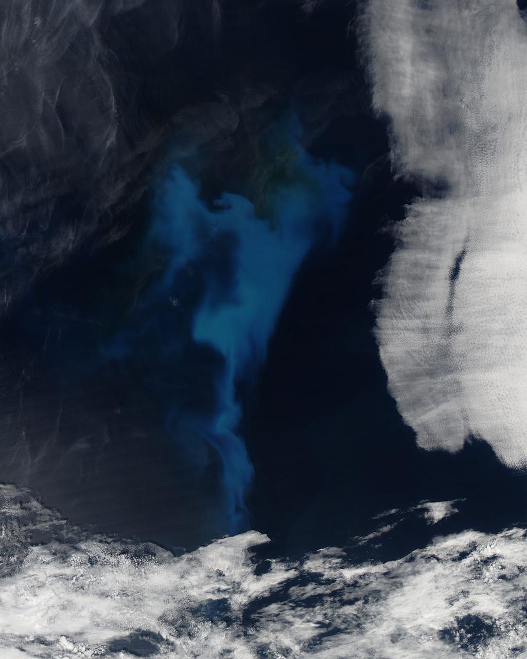
On July 23, 2013 the deep blue waters of the central North Atlantic Ocean provided a background for a spectacular bloom of phytoplankton. The Moderate Resolution Imaging Spectroradiometer (MODIS) captured this true-color image of the event at 16:25 UTC (12:25 p.m. EDT) that same day. Phytoplankton are tiny single-celled photosynthetic organisms that live suspended in a watery environment. They are primary producers in the ocean, forming the base of the marine food chain, and, like terrestrial plants, take up carbon dioxide, make carbohydrates from energy from light, and release oxygen. Phytoplankton live in the ocean year round, but are usually not visible. When light, nutrients and water temperature are just right, however, a colony can explode into growth, creating huge blooms that stain the ocean for miles. While each organism lives only a short time, the high reproductive means that a bloom can last for days or weeks. Credit: NASA/GSFC/Jeff Schmaltz/MODIS Land Rapid Response Team <b><a href="http://www.nasa.gov/audience/formedia/features/MP_Photo_Guidelines.html" rel="nofollow">NASA image use policy.</a></b> <b><a href="http://www.nasa.gov/centers/goddard/home/index.html" rel="nofollow">NASA Goddard Space Flight Center</a></b> enables NASA’s mission through four scientific endeavors: Earth Science, Heliophysics, Solar System Exploration, and Astrophysics. Goddard plays a leading role in NASA’s accomplishments by contributing compelling scientific knowledge to advance the Agency’s mission. <b>Follow us on <a href="http://twitter.com/NASA_GoddardPix" rel="nofollow">Twitter</a></b> <b>Like us on <a href="http://www.facebook.com/pages/Greenbelt-MD/NASA-Goddard/395013845897?ref=tsd" rel="nofollow">Facebook</a></b> <b>Find us on <a href="http://instagram.com/nasagoddard?vm=grid" rel="nofollow">Instagram</a></b>
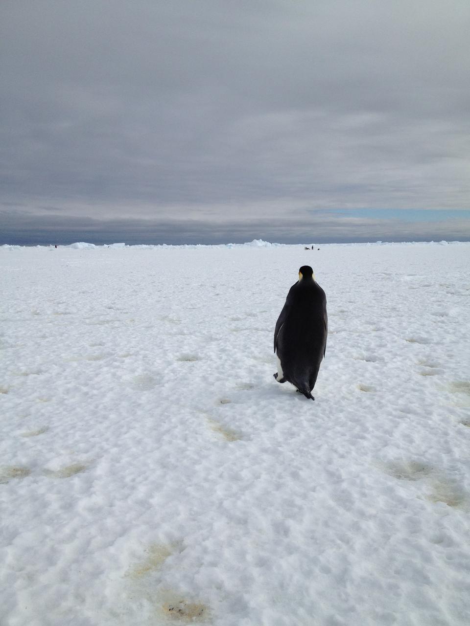
An emperor penguin waddles away on Christmas morning in Antarctica. On Christmas day, the BARREL team visited a penguin colony. Credit: NASA --- In Antarctica in January, 2013 – the summer at the South Pole – scientists launched 20 balloons up into the air to study an enduring mystery of space weather: when the giant radiation belts surrounding Earth lose material, where do the extra particles actually go? The mission is called BARREL (Balloon Array for Radiation belt Relativistic Electron Losses) and it is led by physicist Robyn Millan of Dartmouth College in Hanover, NH. Millan provided photographs from the team’s time in Antarctica. The team launched a balloon every day or two into the circumpolar winds that circulate around the pole. Each balloon floated for anywhere from 3 to 40 days, measuring X-rays produced by fast-moving electrons high up in the atmosphere. BARREL works hand in hand with another NASA mission called the Van Allen Probes, which travels through the Van Allen radiation belts surrounding Earth. The belts wax and wane over time in response to incoming energy and material from the sun, sometimes intensifying the radiation through which satellites must travel. Scientists wish to understand this process better, and even provide forecasts of this space weather, in order to protect our spacecraft. As the Van Allen Probes were observing what was happening in the belts, BARREL tracked electrons that precipitated out of the belts and hurtled down Earth’s magnetic field lines toward the poles. By comparing data, scientists will be able to track how what’s happening in the belts correlates to the loss of particles – information that can help us understand this mysterious, dynamic region that can impact spacecraft. Having launched balloons in early 2013, the team is back at home building the next set of payloads. They will launch 20 more balloons in 2014. <b><a href="http://www.nasa.gov/audience/formedia/features/MP_Photo_Guidelines.html" rel="nofollow">NASA image use policy.</a></b> <b><a href="http://www.nasa.gov/centers/goddard/home/index.html" rel="nofollow">NASA Goddard Space Flight Center</a></b> enables NASA’s mission through four scientific endeavors: Earth Science, Heliophysics, Solar System Exploration, and Astrophysics. Goddard plays a leading role in NASA’s accomplishments by contributing compelling scientific knowledge to advance the Agency’s mission. <b>Follow us on <a href="http://twitter.com/NASA_GoddardPix" rel="nofollow">Twitter</a></b> <b>Like us on <a href="http://www.facebook.com/pages/Greenbelt-MD/NASA-Goddard/395013845897?ref=tsd" rel="nofollow">Facebook</a></b> <b>Find us on <a href="http://instagram.com/nasagoddard?vm=grid" rel="nofollow">Instagram</a></b>

ISS015-E-07928 (13 May 2007) --- Isla San Lorenzo and Isla Las Animas are featured in this image photographed by an Expedition 15 crewmember on the International Space Station. Located in the northern Gulf of California, Isla (island) San Lorenzo and Isla Las Animas -- part of the Midriff Islands -- record geologic processes involved in the creation of the Baja California peninsula over several hundred million years, according to scientists. A geologist walking along the 17-kilometer long central ridge of Isla San Lorenzo from the southeastern to the northwestern end would first encounter Cretaceous granitic rock in the southeastern third of the island (light tan, center left). The central third of the island is comprised mainly of older Paleozoic metamorphic rocks (brown, center; directly above "Isla San Lorenzo"). Together, these very old rocks form the crystalline "basement" of the island. The northwestern third of Isla San Lorenzo, and much of adjacent Isla Las Animas, is composed of much more recent volcanic and marine sedimentary rocks (yellow-brown to light brown, center right). According to scientists, these rocks were formed by volcanoes and fissure eruptions in and around basins in the growing Gulf of California between 5-8 million years ago. The islands themselves were formed as a result of uplift of crustal blocks along the southeastward-trending San Andreas Fault. This image illustrates the largely pristine nature of these islands. The islands are located in the rain shadow of mountains on the Baja Peninsula to the west, and arid conditions prevail through much of the year. The scarcity of water has limited human presence on the islands, and allowed flora and fauna unique to each island (known as endemic species) to flourish -- particularly reptiles. The islands are also home to colonies of seabirds and seals, both of which take advantage of deep productive waters adjacent to the eastern Baja coast. Shallow waters and high levels of nutrients can also lead to blooms of green phytoplankton; two such blooms can be seen along the coastline of Isla Las Animas (center right, in north and west-facing embayments). Surface water patterns around the islands -- enhanced by sunlight reflectance off the water surface -- are due to wind- and current-induced roughness (silver-gray regions). Regions of dark blue water are indicative of calm surface conditions, or the presence of oils and surfactants that decrease surface tension.