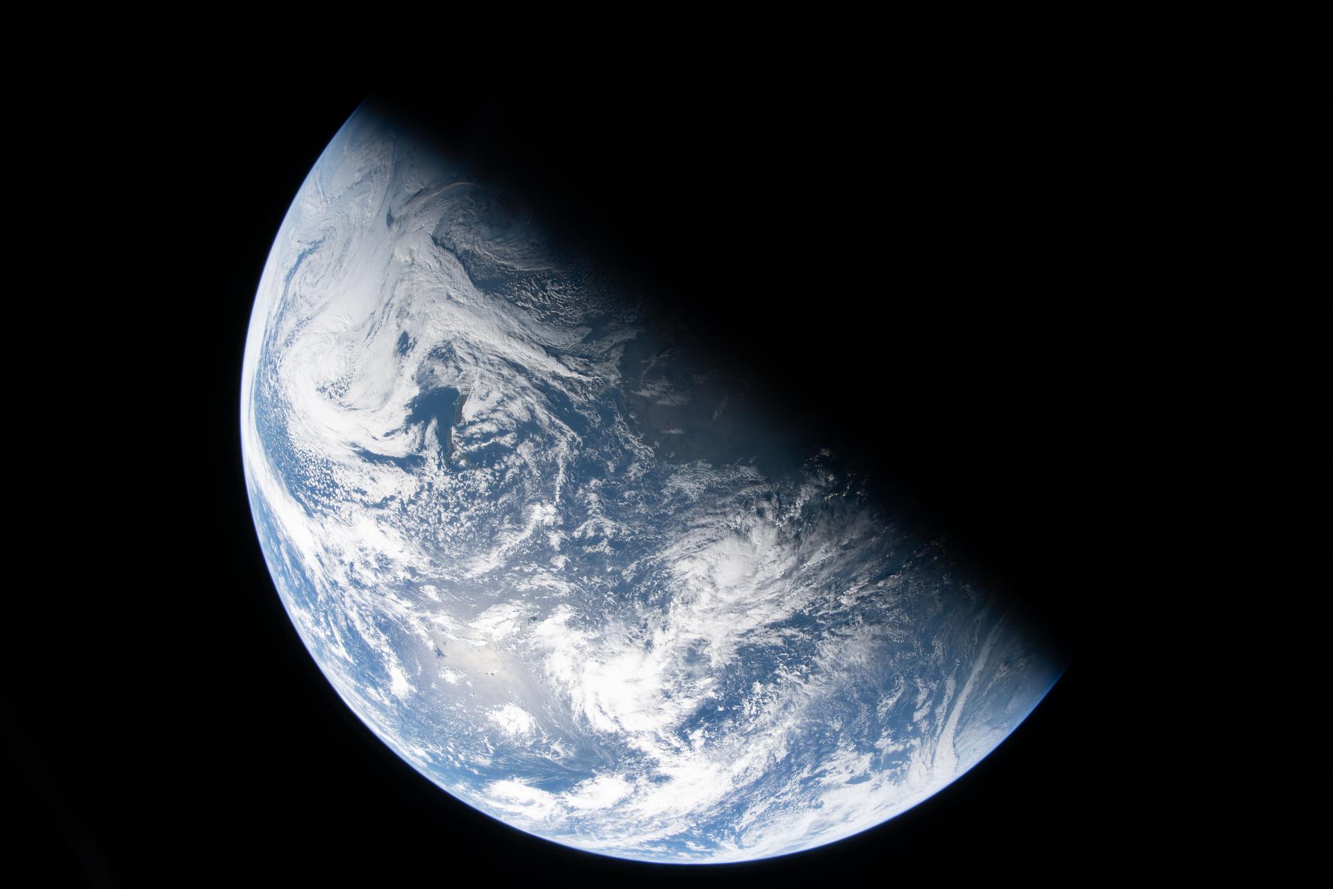
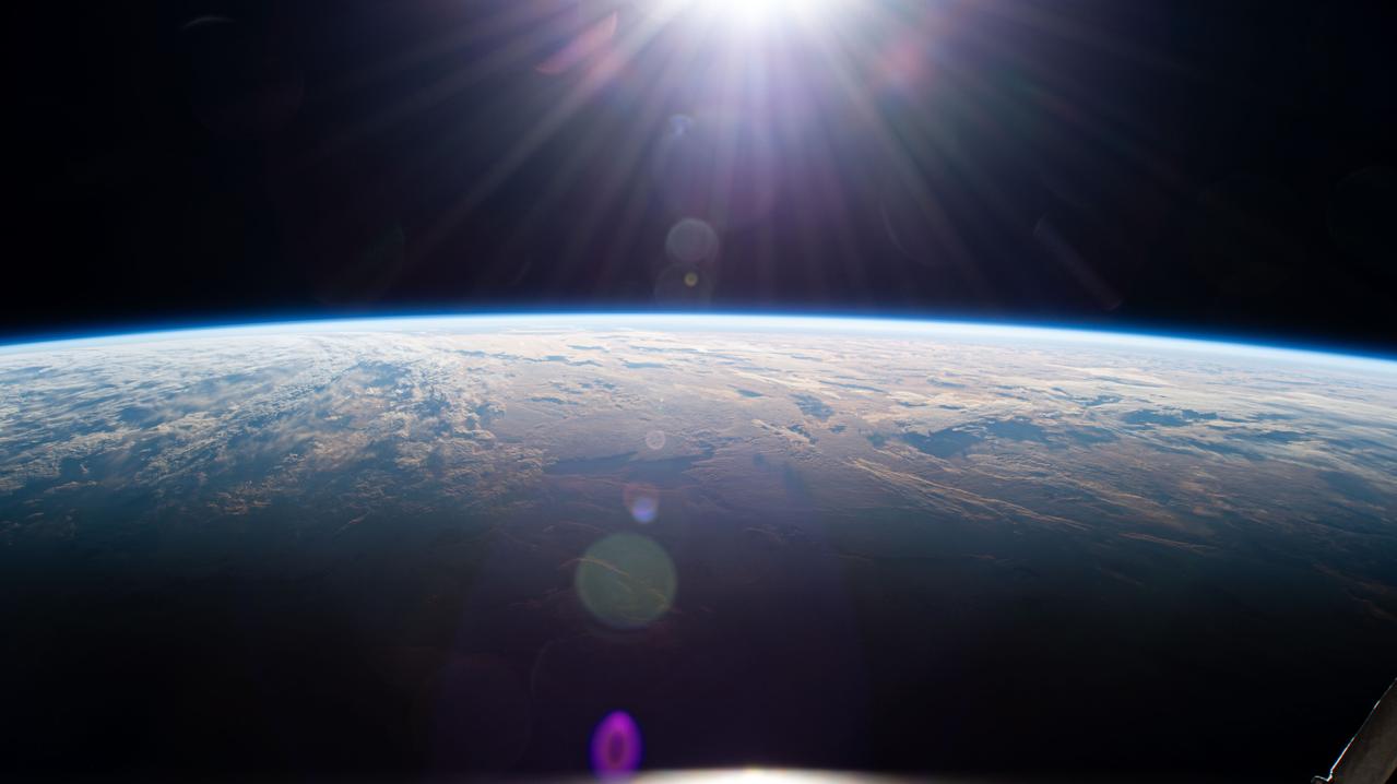
art002e000190 (April 3, 2026) - A view of Earth taken by NASA astronaut and Artemis II Commander Reid Wiseman from one of the Orion spacecraft's four windows after completing the translunar injection burn on April 2, 2026.
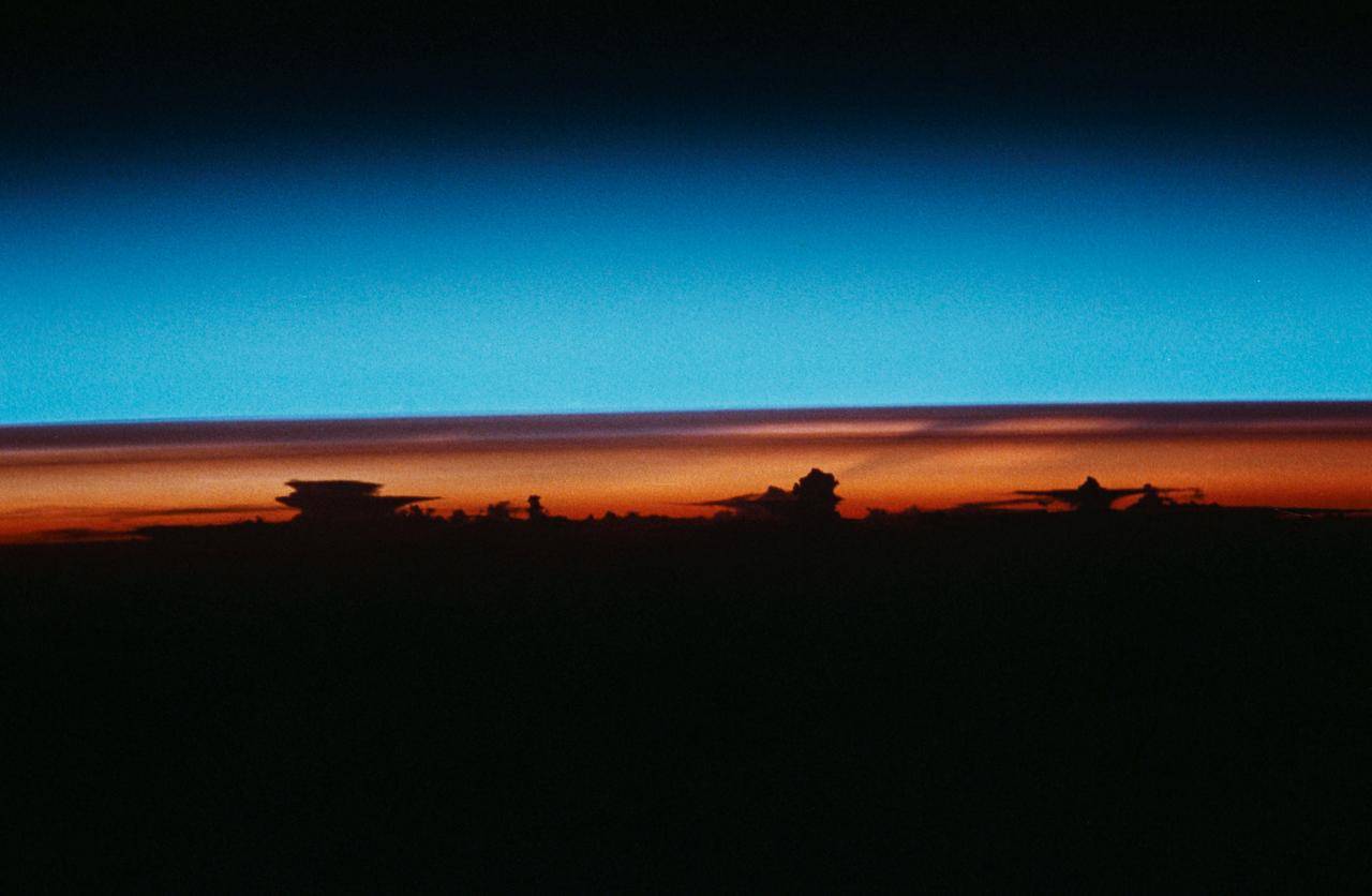
STS-43 Earth observation taken aboard Atlantis, Orbiter Vehicle (OV) 104, captures the Earth's limb at sunrise with unusual cloud patterns silhouetted by the sunlight and rising into the terminator lines.
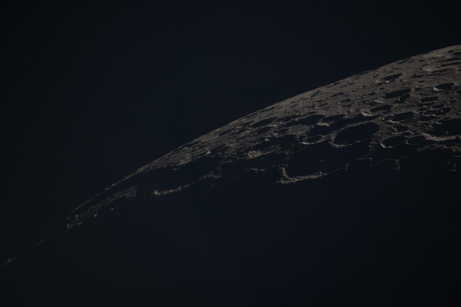
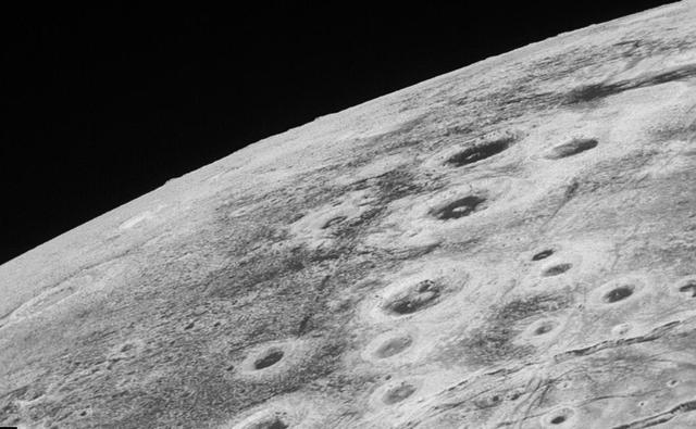
art002e014045 (April 6, 2026) - This view of the Moon captures the terminator—the shifting boundary between day and night—where sunlight grazes the surface at a low angle. Taken by the crew during the Artemis II mission, the lighting accentuates the Moon’s rugged terrain, casting long shadows that reveal the depth and structure of craters, ridges, and surrounding highlands.

This image, taken by NASA's Dawn spacecraft, shows cratered terrain near the day-night line, called the terminator, on dwarf planet Ceres. The image, with a resolution of 1,400 feet (410 meters) per pixel, was taken at an altitude of 2,700 miles (4,400 kilometers) on June 24, 2015. http://photojournal.jpl.nasa.gov/catalog/PIA19611
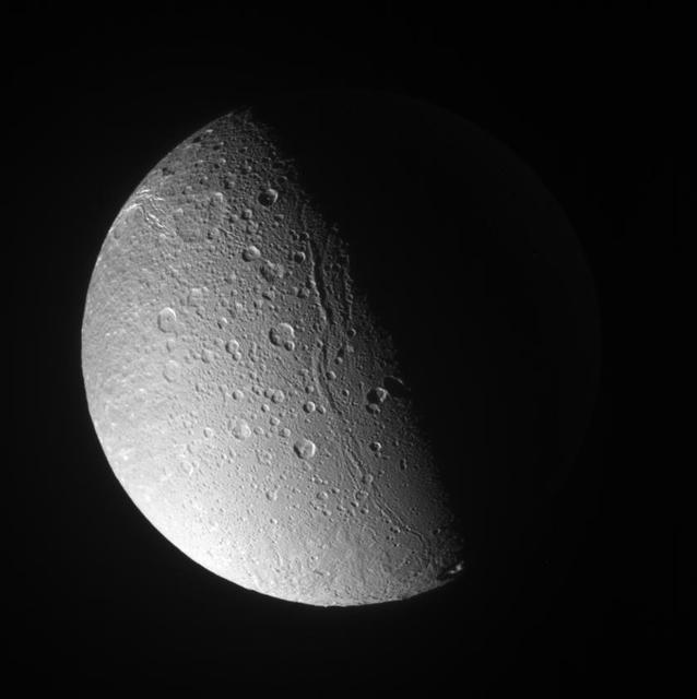
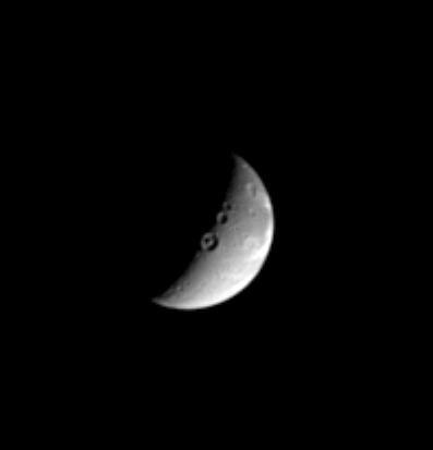
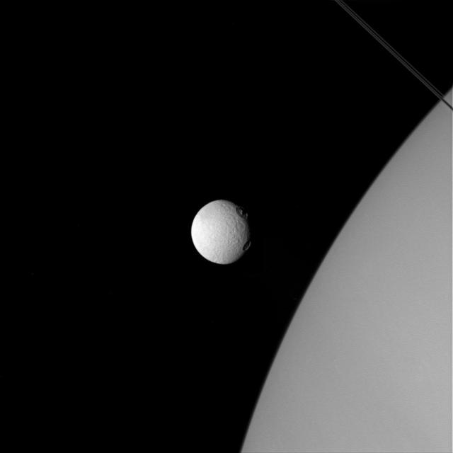
Rhea sports an immense impact scar on its leading hemisphere, like several other major Saturnian moons. The impact basin, seen above center on the day-night dividing line, or terminator, is named Tirawa
Canyons and mountain peaks snake along the terminator on the crater-covered, icy moon Dione. With the Sun at a low angle on their local horizon, the line of mountain ridges above center casts shadows toward the east
This archival image mosaic from NASA Voyager 1 shows Io south polar region. The South Pole is near the terminator line between daylight and night at right center. Haemus Mons, a 10-km high 32,000 foot mountain is at bottom. http://photojournal.jpl.nasa.gov/catalog/PIA00327
STS-30 Earth observation captured by crewmembers onboard Atlantis, Orbiter Vehicle (OV) 104, shows the sunset over the Earth as well as the planet Venus near the center of the frame. Jutting clouds are seen on the horizon, just beneath the blue strip of airglow.
iss068e068975 (March 6, 2023) --- The International Space Station orbits 264 miles above the Atlantic Ocean off the coast of Namibia and into an orbital sunset marked by the terminator, or the line separating day from night on Earth.
iss072e838362 (March 26, 2025) --- Sunrise above Earth's horizon begins illuminating a cloudy Indian Ocean and reveals the terminator, the dividing line between night and day, in this photograph from the International Space Station as it orbited 271 miles above.
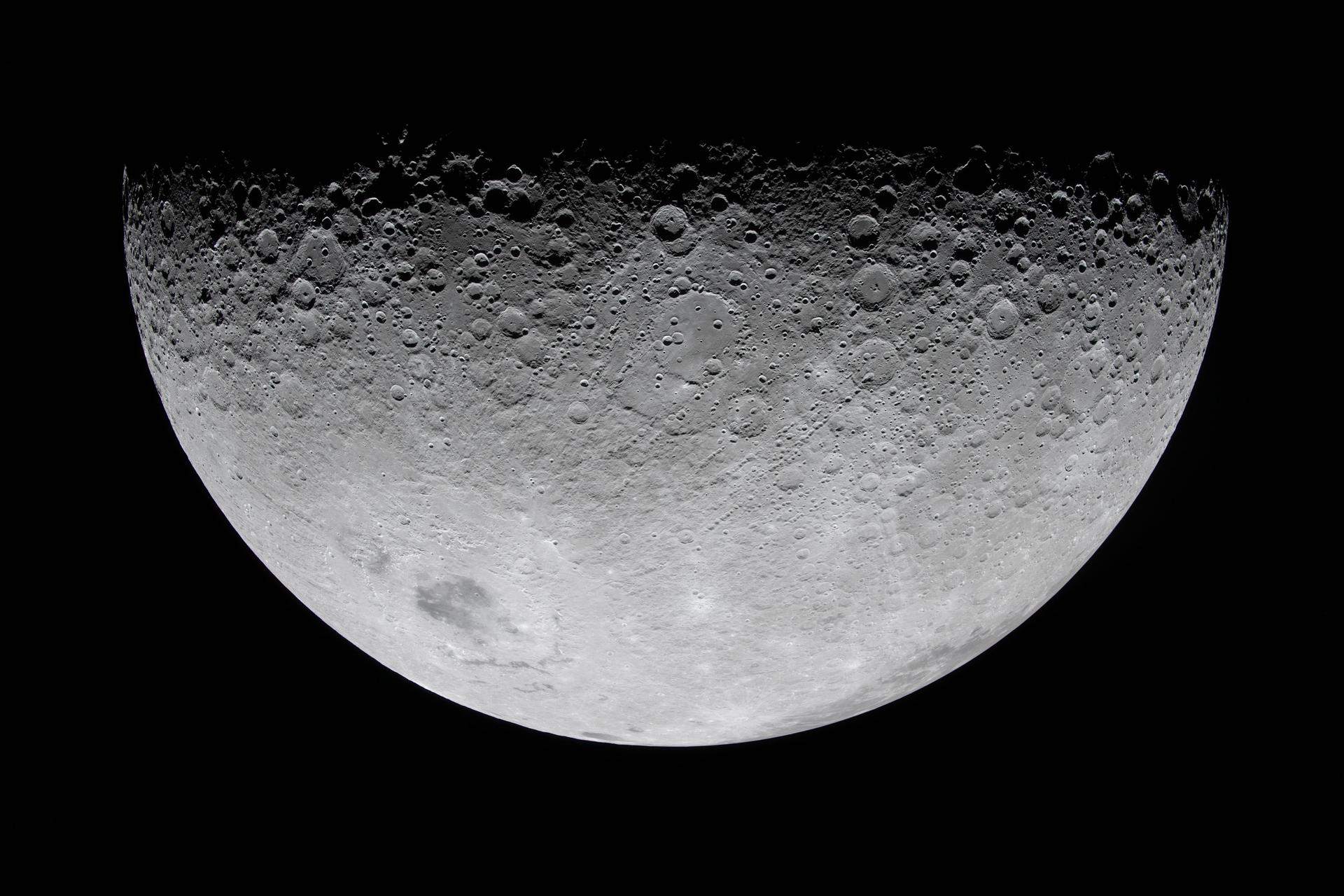
art002e010208 (April 6, 2026) - As the Artemis II crew flew over the terminator, the astronauts described this boundary between day and night as "anything but a straight line." Crater rims along the terminator stand out as "islands" in the night. Giant chains of craters emanating from the 3.7-billion-year-old Orientale basin can be seen scouring the surface, stretching almost to the terminator. This tells a geologic story: these crater chains produced by the Orientale impact event mar the surface of the relatively flat Hertzsprung Basin (center of this image), which means that Hertzsprung Basin must be even older than Orientale!
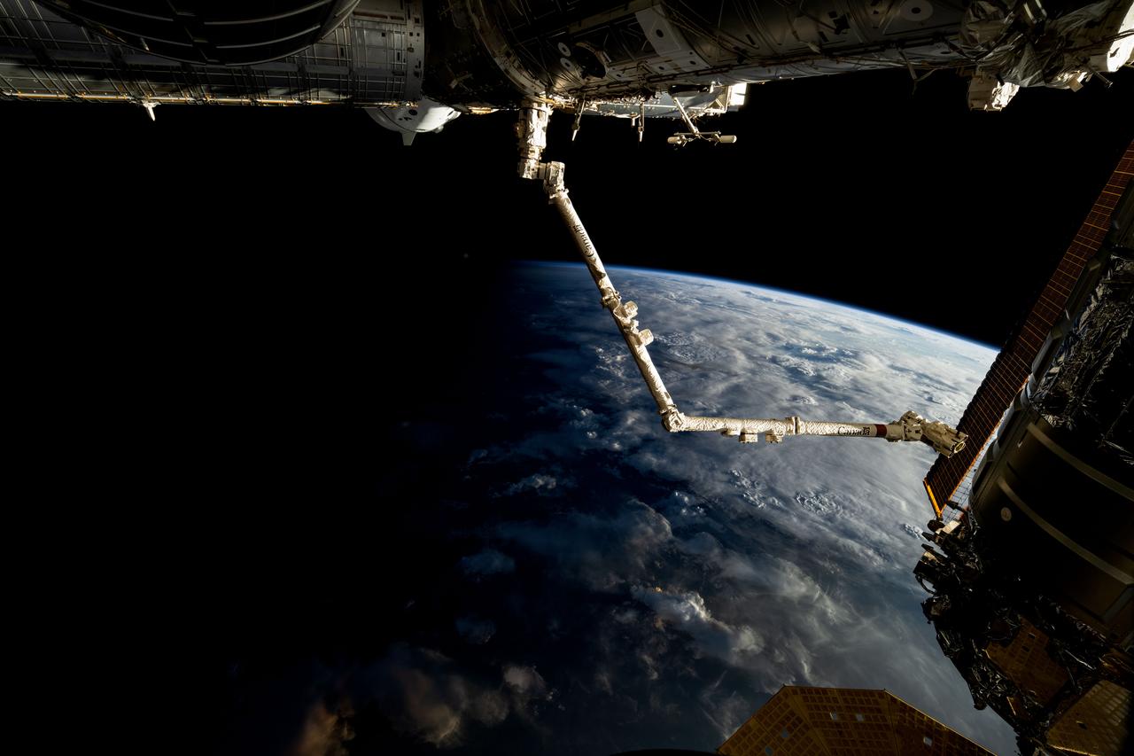
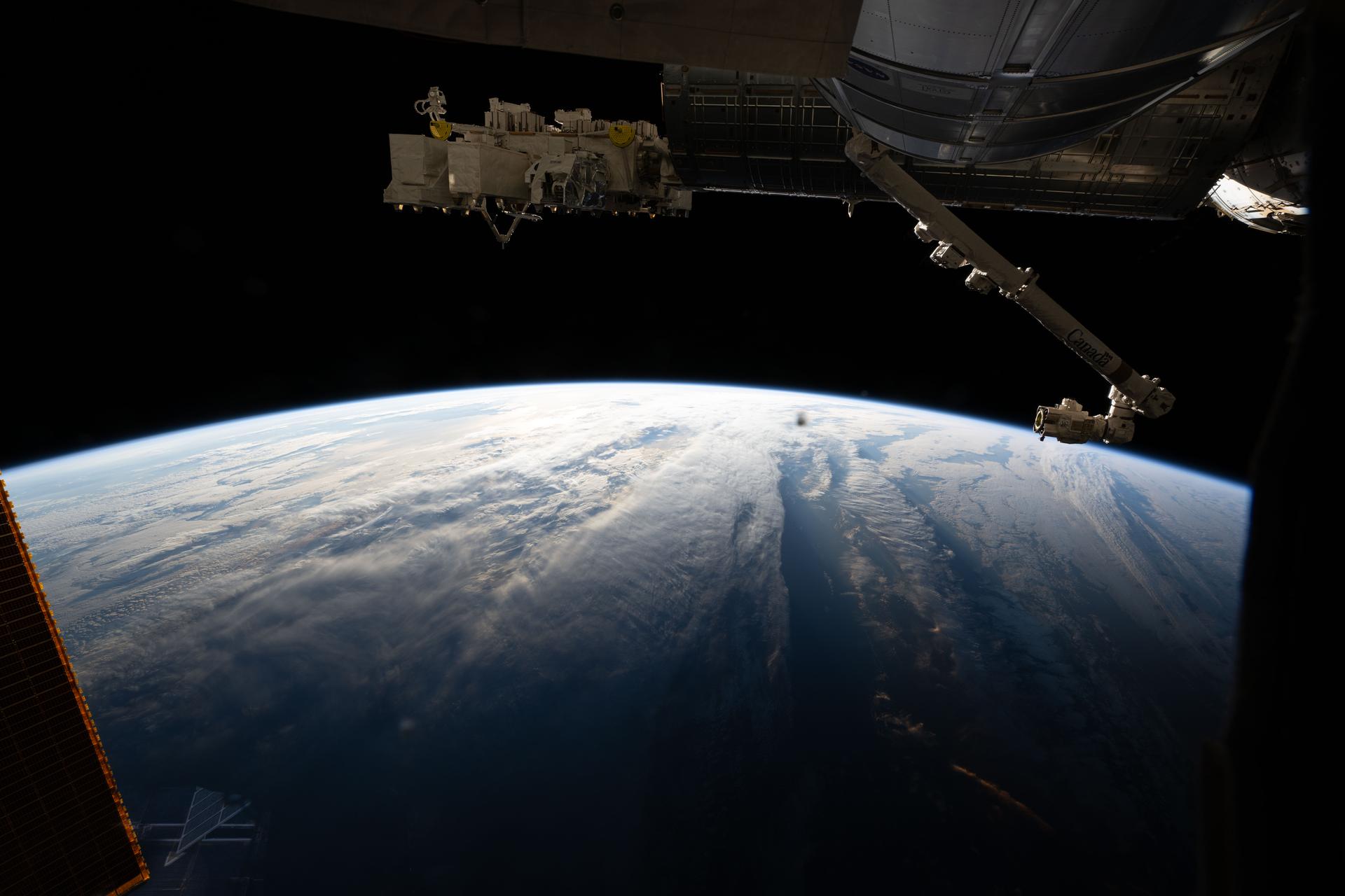
iss072e032723 (Oct. 8, 2024) --- The 57.7-foot-long Candarm2 robotic arm extends from the Harmony module as the International Space Station orbits above the terminator, the line that separates Earth's daytime from nighttime, 261 miles above the African nation of Sudan. Obscured behind Harmony toward upper left, is the SpaceX Dragon Freedom spacecraft.
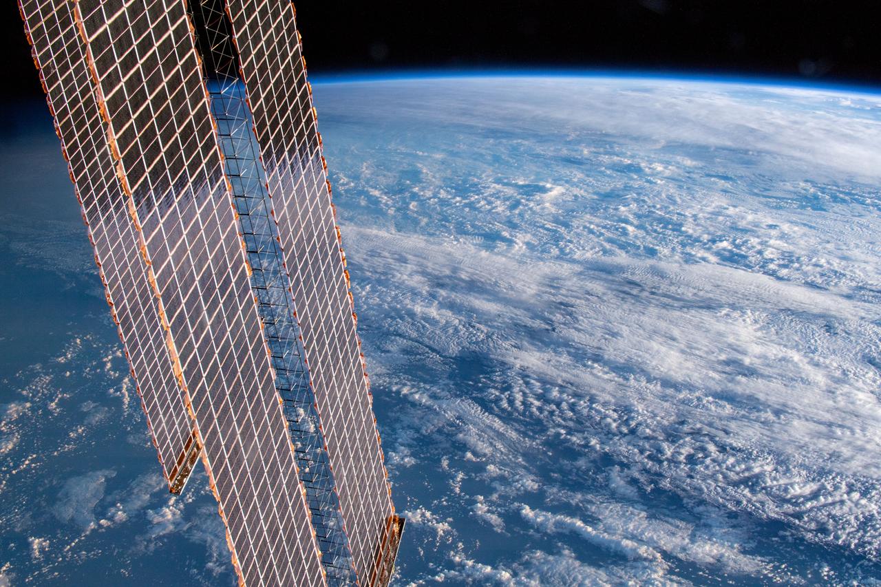
iss059e019924 (April 11, 2019) --- 261 miles above Earth and off the coast of the Australian cities of Gold Coast and Brisbane, an Expedition 59 crew member photographed the cloud-covered Tasman and Coral Seas. A portion of the International Space Station's solar arrays drape over the Earth as the orbital lab passes over the terminator, the line that separates night from day.
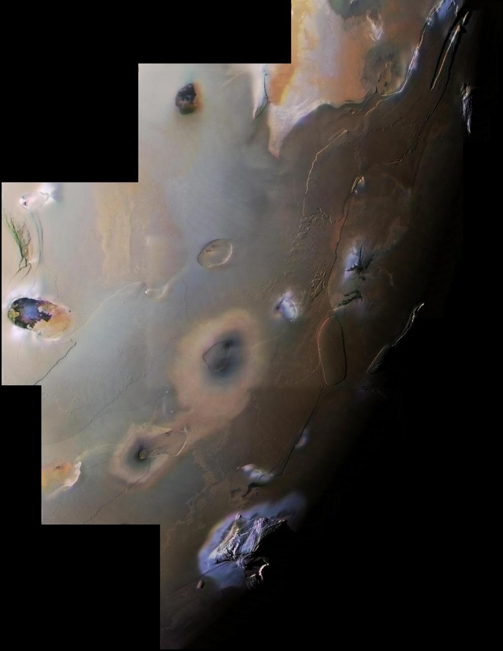
This image of Jupiter's moon Io was taken by the JunoCam visible-light imager as NASA's Juno spacecraft flew past the Jovian moon on October 15, 2023. A plume over the location of the volcano Prometheus can be seen just standing out from the darkness on the left side of the image, just below the terminator (the line dividing day and night). https://photojournal.jpl.nasa.gov/catalog/PIA26235
iss059e025207 (April 17, 2019) --- The International Space Station crosses the terminator, the line that separates night and day on Earth, as it orbits 254 miles above the Gulf of Guinea on Africa's mid-western coast. Portions of the orbital complex can be seen including a pair of high-pressure gas tanks, solar arrays and the Soyuz MS-12 crew ship docked to the Rassvet module.
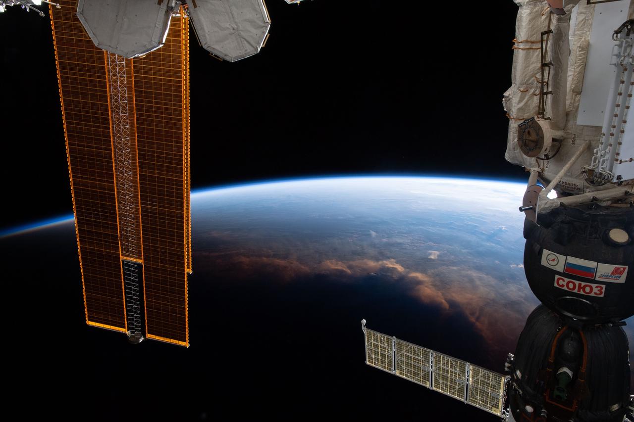
iss074e0519830 (March 15, 2026) --- The International Space Station orbits 267 miles above a cloudy Atlantic Ocean southwest of Cape Town, South Africa. The Kibo laboratory module's External Platform and the Canadarm2 robotic arm highlight the top foreground above Earth's terminator—the line between night and day—in this photograph taken at approximately 6:36 a.m. local time. Credit: ESA/Sophie Adenot
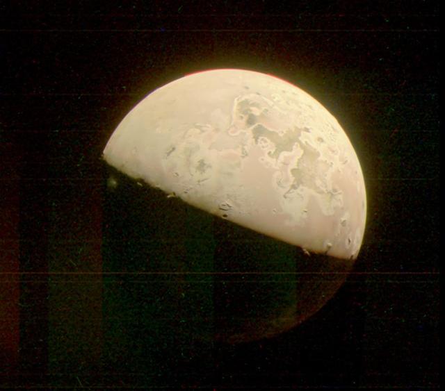
NASA's Juno mission captured this view of Jupiter's intriguing, icy moon Europa during a close pass on Sept. 29, 2022. The contrast has been enhanced to help scientists look for signs of eruptions along the limb and terminator – the dividing line between the day and night sides of the moon. None were identified. When processed this way, the image shows features on Europa's night side illuminated by sunlight reflected from Jupiter, also called Jupiter shine. Along the terminator, low-angle sunlight highlights topography on the moon's surface. At the time the image was taken, the Juno spacecraft was 945 miles (1,521 kilometers) from Europa. Citizen scientist Brian Swift processed the image from raw data from the spacecraft's JunoCam public engagement camera, brightening darker regions and enhancing the contrast. https://photojournal.jpl.nasa.gov/catalog/PIA25694
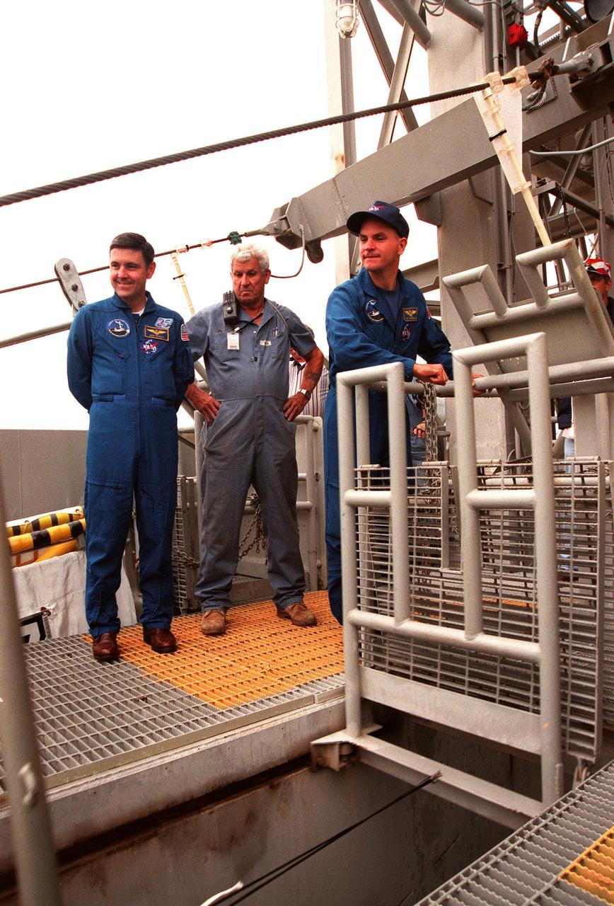
KENNEDY SPACE CENTER, Fla. -- STS-88 Mission Commander Robert D. Cabana (left) and Pilot Frederick W. "Rick" Sturckow (right) examine part of the emergency egress system at Launch Pad 39A, during Terminal Countdown Demonstration Test (TCDT) activities. Standing between them is an unidentified KSC worker. The crew are at KSC to participate in the Terminal Countdown Demonstration Test (TCDT), a dress rehearsal for launch. Mission STS-88 is targeted for launch on Dec. 3, 1998. It is the first U.S. flight for the assembly of the International Space Station and will carry the Unity connecting module. Unity will be mated with the already orbiting Russian-built Zarya control module. The 12-day mission includes three planned spacewalks to connect power, data and utility lines and install exterior equipment
STS-88 Mission Specialists Sergei Konstantinovich Krikalev (left) and James H. Newman (right) sit inside orbiter Endeavour during Terminal Countdown Demonstration Activities (TCDT). The TCDT includes mission familiarization activities, emergency egress training, and the simulated main engine cut-off exercise. Mission STS-88 is targeted for launch on Dec. 3, 1998. It is the first U.S. flight for the assembly of the International Space Station and will carry the Unity connecting module. Unity will be mated with the already orbiting Russian-built Zarya control module. The 12-day mission includes three planned spacewalks to connect power, data and utility lines and install exterior equipment
The STS-102 crew watches a slidewire basket speed down the line to the landing area. At left (backs to camera, back to front) are Commander James Wetherbee, Mission Specialists Susan Helms and Paul Richards. At right are (left to right) Mission Specialists Andrew Thomas and James Voss and Pilot James Kelly. Not seen is Mission Specialist Yury Usachev. The crew is taking part in Terminal Countdown Demonstration Test activities, which include the emergency exit training and a simulated launch countdown. STS-102 is the eighth construction flight to the International Space Station, with Space Shuttle Discovery carrying the Multi-Purpose Logistics Module Leonardo. Launch on mission STS-102 is scheduled for March 8
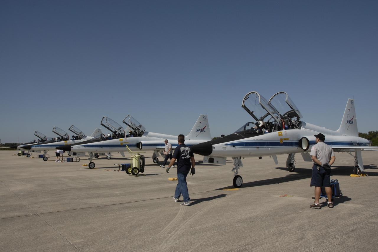
CAPE CANAVERAL, Fla. - T-38 jets are lined up on the tarmac of the Shuttle Landing Facility at NASA's Kennedy Space Center in Florida. The crew members of space shuttle Atlantis' STS-129 mission were among the pilots and passengers. The crew has arrived at Kennedy for training related to their launch dress rehearsal, the Terminal Countdown Demonstration Test. Launch of Atlantis on its STS-129 mission to the International Space Station is targeted for November. For information on the STS-129 mission objectives and crew, visit http://www.nasa.gov/mission_pages/shuttle/shuttlemissions/sts129/index.html. Photo credit: NASA/Kim Shiflett
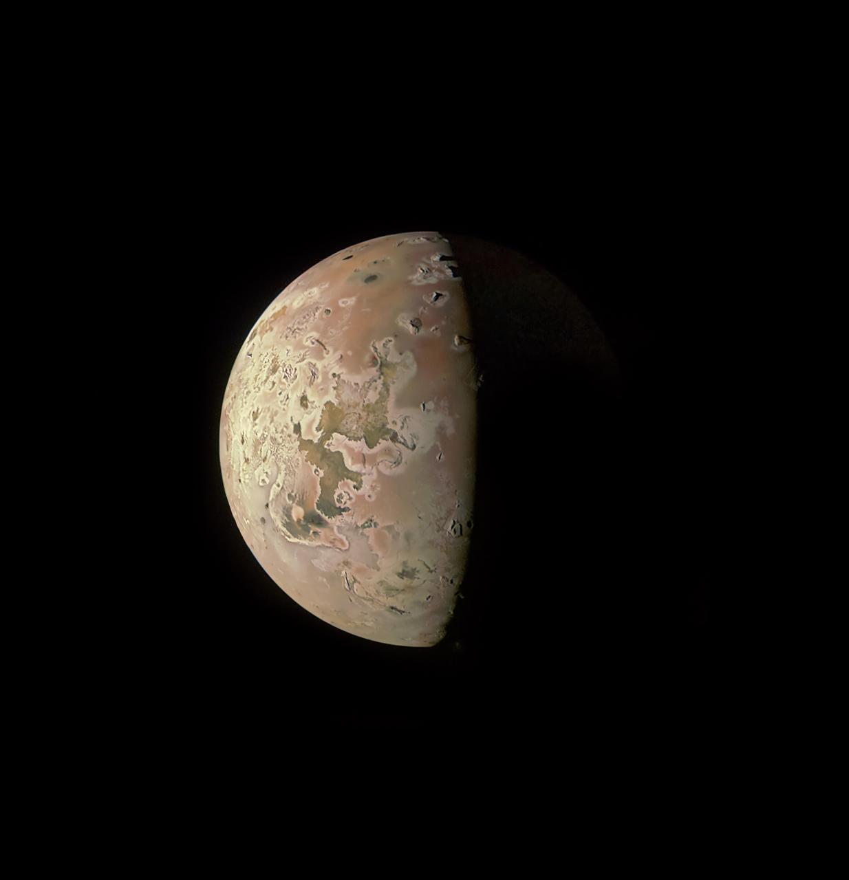
This image revealing the north polar region of the Jovian moon Io was taken on October 15, 2023, by the JunoCam imager aboard NASA's Juno spacecraft. Since the high latitudes were not well covered in imagery gathered by NASA's Voyager and Galileo missions, three of the peaks captured here were observed for the first time. Those mountains are seen at the upper part of the image, near the terminator (the line dividing day and night). At the time the image was taken, the Juno spacecraft was about 7,270 miles (11,700 kilometers) above Io's surface. Citizen scientist Ted Stryk made this image using raw data from the JunoCam instrument, processing the data to enhance details. https://photojournal.jpl.nasa.gov/catalog/PIA26234
CAPE CANAVERAL, Fla. -- In the White Room on Launch Pad 39A at NASA's Kennedy Space Center, STS-124 Mission Specialist Ron Garan is ready for the simulated launch countdown, part of the launch dress rehearsal known as the terminal countdown demonstration test. The simulation serves as a practice exercise in which both the launch team and flight crew rehearse launch day time lines and procedures. The test culminates in a simulated ignition and automated shutdown of the orbiter's main engines. On the STS-124 mission, the crew will deliver and install the Japanese Experiment Module – Pressurized Module and Japanese Remote Manipulator System. Discovery's launch is targeted for May 31. Photo credit: NASA/Amanda Diller
STS-88 Mission Specialists Nancy J. Currie, Ph.D., (back) and Jerry L. Ross (front) check over equipment inside orbiter Endeavour during Terminal Countdown Demonstration Activities (TCDT). The TCDT includes mission familiarization activities, emergency egress training, and the simulated main engine cut-off exercise. Mission STS-88 is targeted for launch on Dec. 3, 1998. It is the first U.S. flight for the assembly of the International Space Station and will carry the Unity connecting module. Unity will be mated with the already orbiting Russian-built Zarya control module. The 12-day mission includes three planned spacewalks to connect power, data and utility lines and install exterior equipment

At the commissioning of a new high-pressure helium pipeline at Kennedy Space Center, participants watch as helium-filled balloons take to the sky after their lines were cut. From left, they are Center Director Roy Bridges; Michael Butchko, president, SGS; Pierre Dufour, president and CEO, Air Liquide America Corporation; David Herst, director, Delta IV Launch Sites; Pamela Gillespie, executive administrator, office of Congressman Dave Weldon; and Col. Samuel Dick, representative of the 45th Space Wing. The nine-mile-long buried pipeline will service launch needs at the new Delta IV Complex 37 at Cape Canaveral Air Force Station. It will also serve as a backup helium resource for Shuttle launches. Nearly one launch’s worth of helium will be available in the pipeline to support a Shuttle pad in an emergency. The line originates at the Helium Facility on KSC and terminates in a meter station at the perimeter of the Delta IV launch pad. Others at the ceremony were Jerry Jorgensen, pipeline project manager, Space Gateway Support (SGS), and Ramon Lugo, acting executive director, JPMO

At the commissioning of a new high-pressure helium pipeline at Kennedy Space Center, participants watch as helium-filled balloons take to the sky after their lines were cut. From left, they are Center Director Roy Bridges; Michael Butchko, president, SGS; Pierre Dufour, president and CEO, Air Liquide America Corporation; David Herst, director, Delta IV Launch Sites; Pamela Gillespie, executive administrator, office of Congressman Dave Weldon; and Col. Samuel Dick, representative of the 45th Space Wing. The nine-mile-long buried pipeline will service launch needs at the new Delta IV Complex 37 at Cape Canaveral Air Force Station. It will also serve as a backup helium resource for Shuttle launches. Nearly one launch’s worth of helium will be available in the pipeline to support a Shuttle pad in an emergency. The line originates at the Helium Facility on KSC and terminates in a meter station at the perimeter of the Delta IV launch pad. Others at the ceremony were Jerry Jorgensen, pipeline project manager, Space Gateway Support (SGS), and Ramon Lugo, acting executive director, JPMO
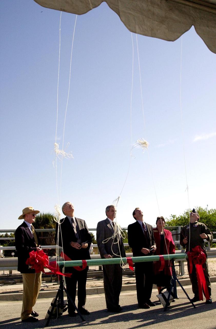
At the commissioning of a new high-pressure helium pipeline at Kennedy Space Center, participants cut the lines to helium-filled balloons. From left, they are Center Director Roy Bridges; Michael Butchko, president, SGS; Pierre Dufour, president and CEO, Air Liquide America Corporation; David Herst, director, Delta IV Launch Sites; Pamela Gillespie, executive administrator, office of Congressman Dave Weldon; and Col. Samuel Dick, representative of the 45th Space Wing. The nine-mile-long buried pipeline will service launch needs at the new Delta IV Complex 37 at Cape Canaveral Air Force Station. It will also serve as a backup helium resource for Shuttle launches. Nearly one launch’s worth of helium will be available in the pipeline to support a Shuttle pad in an emergency. The line originates at the Helium Facility on KSC and terminates in a meter station at the perimeter of the Delta IV launch pad. Others at the ceremony were Jerry Jorgensen, pipeline project manager, Space Gateway Support (SGS), and Ramon Lugo, acting executive director, JPMO
Three sizeable impact craters, including one with a marked central peak, lie along the line that divides day and night on the Saturnian moon, Dione (dee-OH-nee), which is 1,118 kilometers, or 695 miles across. The low angle of the Sun along the terminator, as this dividing line is called, brings details like these craters into sharp relief. This view shows principally the leading hemisphere of Dione. Some of this moon's bright, wispy streaks can be seen curling around its eastern limb. Cassini imaged the wispy terrain at high resolution during its first Dione flyby on Dec. 14, 2004. This image was taken in visible light with the Cassini spacecraft narrow angle camera on Nov. 1, 2004, at a distance of 2.4 million kilometers (1.5 million miles) from Dione and at a Sun-Dione-spacecraft, or phase, angle of 106 degrees. North is up. The image scale is 14 kilometers (8.7 miles) per pixel. The image has been magnified by a factor of two and contrast-enhanced to aid visibility of surface features. http://photojournal.jpl.nasa.gov/catalog/PIA06542
Range : 40,000 km (24,8000 mi.) This picture of Triton is a mosaic of the highest resolution images taken by Voyager 2. The mosaic is superimposed on the lower-resolution mapping images taken about 2 hours earlier in order to fill in gaps between high-resolution images. The smallest features that can be seen on the images are about 0.8 km (0.5 mi.) across. The terminator (line separation day and night) is at the top of the picture and is centered at about 30 degrees north latitude and 330 degrees longitude. These highest-resolution images were targeted for the terminator region to show details of the topography by the shadows it casts. Near the center of the picture is a depression filled with smooth plains that are probably ices which were once erupted in a fluid state. The depth of the depression is about 300 meters (900 feet) and the prominent fresh impact crater on its floor is about 20 km (12 mi.) in diameter and about 1 km (0.6 mi.) deep. On the right is a elongate crater with adjacent dark deposits about it. This feature may be an explosive eruption vent formed by gaps within the ice. The linear structure on the lest is probably a fracture along which fresh ice has been extruded.
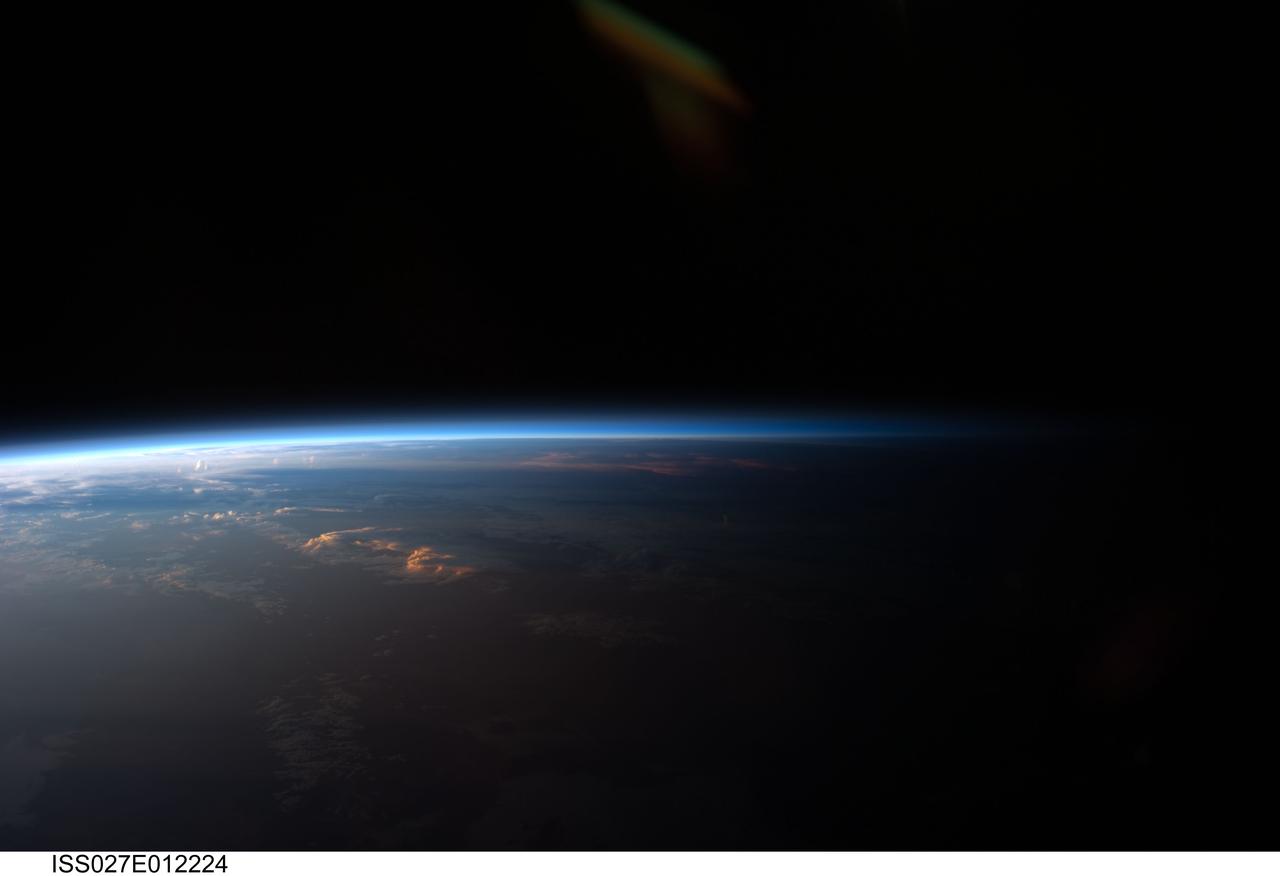
ISS027-E-012224 (12 April 2011) --- Sunset over western South America is featured in this image photographed by an Expedition 27 crew member on the International Space Station. Crew members onboard the space station see, on average, sixteen sunrises and sunsets during a 24-hour orbital period. Each changeover between day and night on the ground is marked by the terminator, or line separating the sunlit side of Earth from the side in darkness. While the terminator is conceptualized as a hard boundary?and is frequently presented as such in graphics and visualizations?in reality the boundary between light and dark is diffuse due to scattering of light by Earth?s atmosphere. This zone of diffuse lighting is experienced as dusk or twilight on the ground ? while the sun is no longer visible, some illumination is still present due to light scattering over the local horizon. The terminator is visible in this photograph trending across the image from lower left to upper right. This panoramic view across central South America, looking towards the northeast, was acquired at approximately 7:37 p.m. local time. Layers of Earth?s atmosphere, colored bright white to deep blue, are visible extending across the horizon (or limb). The highest cloud tops have a reddish glow from the direct light of the setting sun while lower clouds are in twilight. The Salar de Coipasa, a large salt lake in Bolivia, is dimly visible on the night side of the terminator. The salar provides a geographic reference point that allows the location and viewing orientation of the image to be determined.

KENNEDY SPACE CENTER, Fla. -- STS-88 Mission Specialists Sergei Konstantinovich Krikalev (left) and James H. Newman (right) are ready to leave Launch Pad 39A in the slidewire basket during an emergency egress exercise. The crew are at KSC to participate in the Terminal Countdown Demonstration Test (TCDT) which includes mission familiarization activities, emergency egress training, and the simulated main engine cut-off exercise. Mission STS-88 is targeted for launch on Dec. 3, 1998. It is the first U.S. flight for the assembly of the International Space Station and will carry the Unity connecting module. Unity will be mated with the already orbiting Russian-built Zarya control module. The 12-day mission includes three planned spacewalks to connect power, data and utility lines and install exterior equipment
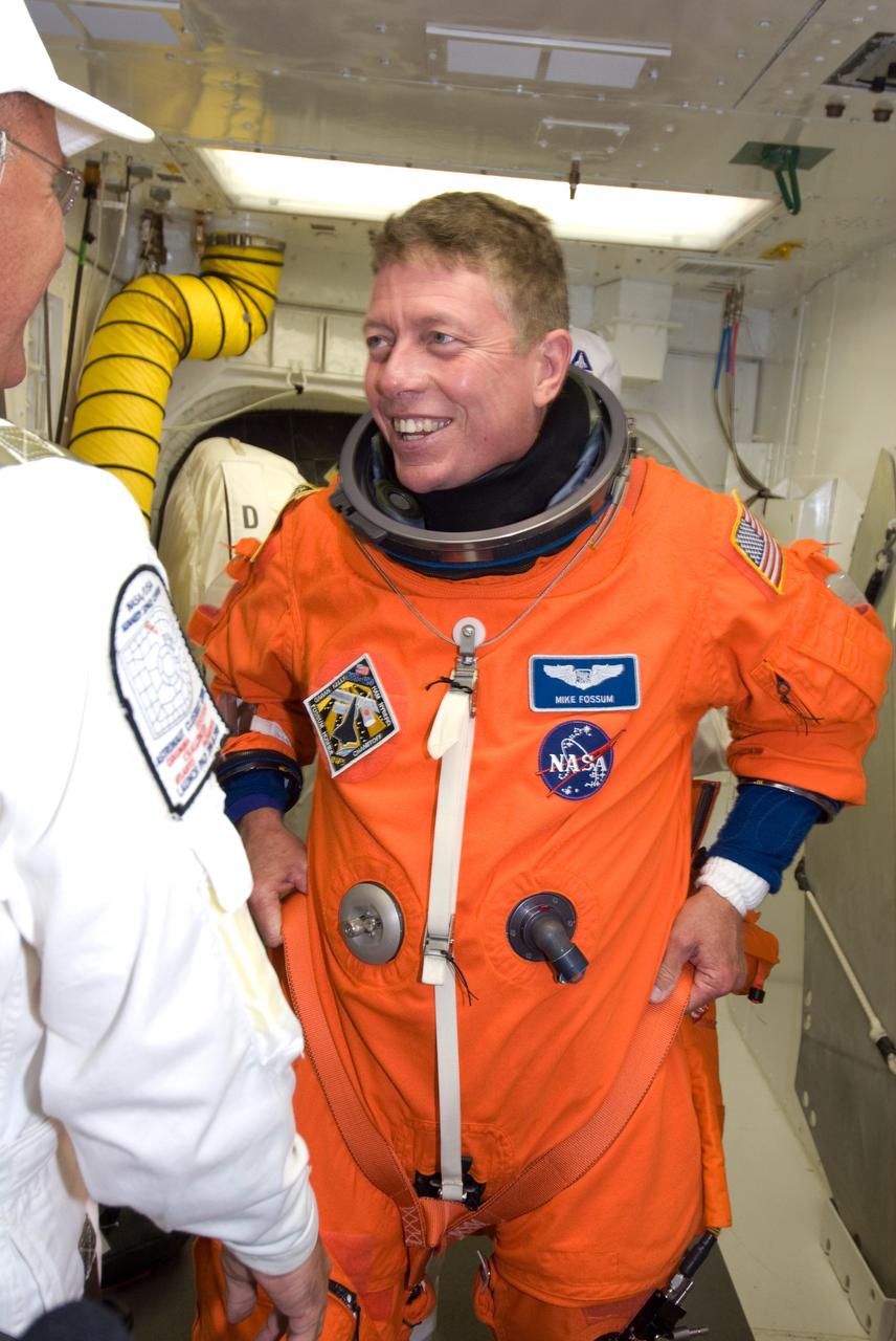
CAPE CANAVERAL, Fla. -- In the White Room on Launch Pad 39A at NASA's Kennedy Space Center, STS-124 Mission Specialist Mike Fossum adjusts the parachute he donned for launch. He and the other crew members are taking part in a simulated launch countdown, part of the launch dress rehearsal known as the terminal countdown demonstration test. The simulation serves as a practice exercise in which both the launch team and flight crew rehearse launch day time lines and procedures. The test culminates in a simulated ignition and automated shutdown of the orbiter's main engines. On the STS-124 mission, the crew will deliver and install the Japanese Experiment Module – Pressurized Module and Japanese Remote Manipulator System. Discovery's launch is targeted for May 31. Photo credit: NASA/Amanda Diller

CAPE CANAVERAL, Fla. -- In the White Room on Launch Pad 39A at NASA's Kennedy Space Center, STS-124 Mission Specialist Greg Chamitoff dons the parachute required for launch. He and the other crew members are taking part in a simulated launch countdown, part of the launch dress rehearsal known as the terminal countdown demonstration test. The simulation serves as a practice exercise in which both the launch team and flight crew rehearse launch day time lines and procedures. The test culminates in a simulated ignition and automated shutdown of the orbiter's main engines. On the STS-124 mission, the crew will deliver and install the Japanese Experiment Module – Pressurized Module and Japanese Remote Manipulator System. Discovery's launch is targeted for May 31. Photo credit: NASA/Amanda Diller
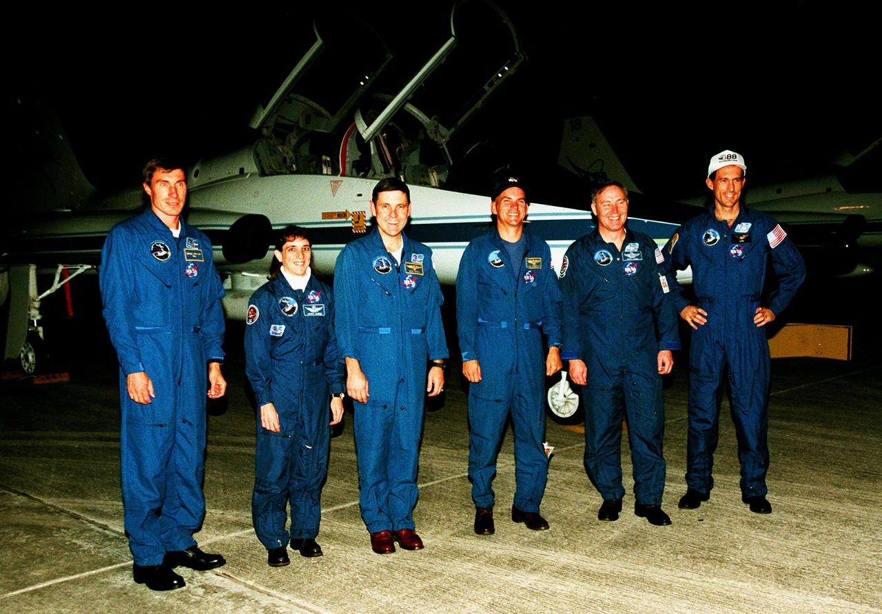
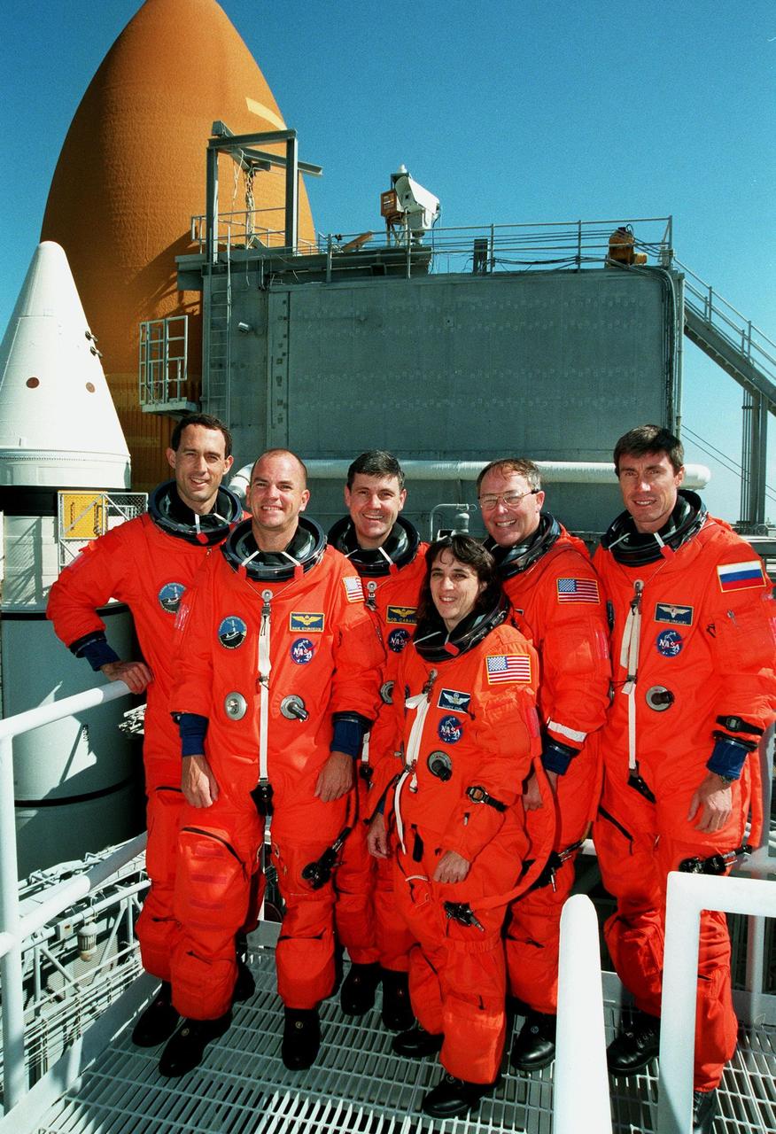
The STS-88 crew members pose for a group photograph in front of a T-38 jet aircraft after their nighttime arrival at the Shuttle Landing Facility to take part in Terminal Countdown Demonstration Test (TCDT) activities. From left to right, they are Mission Specialist Sergei Krikalev, who is a Russian cosmonaut, Mission Specialist Nancy J. Currie, Mission Commander Robert D. Cabana, Pilot Frederick W. "Rick" Sturckow, and Mission Specialists Jerry L. Ross and James H. Newman. The TCDT provides the crew with simulated countdown exercises, emergency egress training, and opportunities to inspect their mission payloads in the orbiter's payload bay. Mission STS-88 is targeted for launch on Dec. 3, 1998. It is the first U.S. flight for the assembly of the International Space Station and will carry the Unity connecting module. Ross and Newman will make three spacewalks to connect power, data and utility lines and install exterior equipment
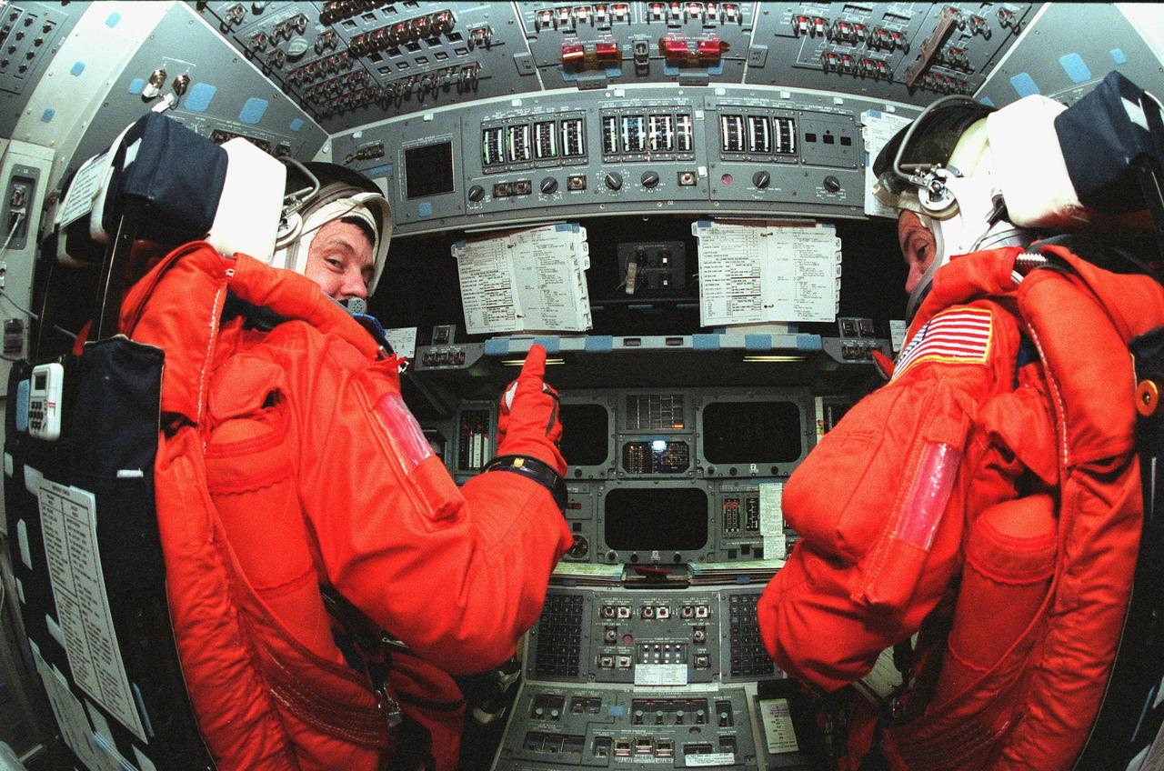
STS-88 Mission Commander Robert D. Cabana (left) and Pilot Frederick W. "Rick" Sturckow (right) take their seats in the flight deck inside orbiter Endeavour during Terminal Countdown Demonstration Activities (TCDT). The TCDT includes mission familiarization activities, emergency egress training, and the simulated main engine cut-off exercise. Mission STS-88 is targeted for launch on Dec. 3, 1998. It is the first U.S. flight for the assembly of the International Space Station and will carry the Unity connecting module. Unity will be mated with the already orbiting Russian-built Zarya control module. The 12-day mission includes three planned spacewalks to connect power, data and utility lines and install exterior equipment

CAPE CANAVERAL, Fla. -- On Launch Pad 39A at NASA's Kennedy Space Center, STS-124 crew members pause on the 195-foot level of the fixed service structure before entering space shuttle Discovery. From left are Commander Mark Kelly and Mission Specialists Karen Nyberg, Mike Fossum, Ron Garan and Akihiko Hoshide, who represents the Japan Aerospace Exploration Agency. The crew is taking part in a simulated launch countdown, part of the launch dress rehearsal known as the terminal countdown demonstration test. The simulation serves as a practice exercise in which both the launch team and flight crew rehearse launch day time lines and procedures. The test culminates in a simulated ignition and automated shutdown of the orbiter's main engines. On the STS-124 mission, the crew will deliver and install the Japanese Experiment Module – Pressurized Module and Japanese Remote Manipulator System. Discovery's launch is targeted for May 31. Photo credit: NASA/Amanda Diller
CAPE CANAVERAL, Fla. -- In the slidewire basket area of Launch Pad 39A at NASA's Kennedy Space Center, the STS-124 crew gets instruction about landing safely. Lined up from left are Mission Specialist Akihiko Hoshide, Commander Mark Kelly, Mission Specialists Ron Garan and Karen Nyberg, Pilot Ken Ham, and Mission Specialists Mike Fossum and Greg Chamitoff. Hoshide represents the Japan Aerospace Exploration Agency. The crew is at Kennedy for a dress launch rehearsal called the terminal countdown demonstration test. TCDT provides astronauts and ground crews with an opportunity to participate in various simulated countdown activities, including equipment familiarization and emergency training. On the STS-124 mission, the crew will deliver and install the Japanese Experiment Module – Pressurized Module and Japanese Remote Manipulator System. Discovery's launch is targeted for May 31. Photo credit: NASA/Kim Shiflett
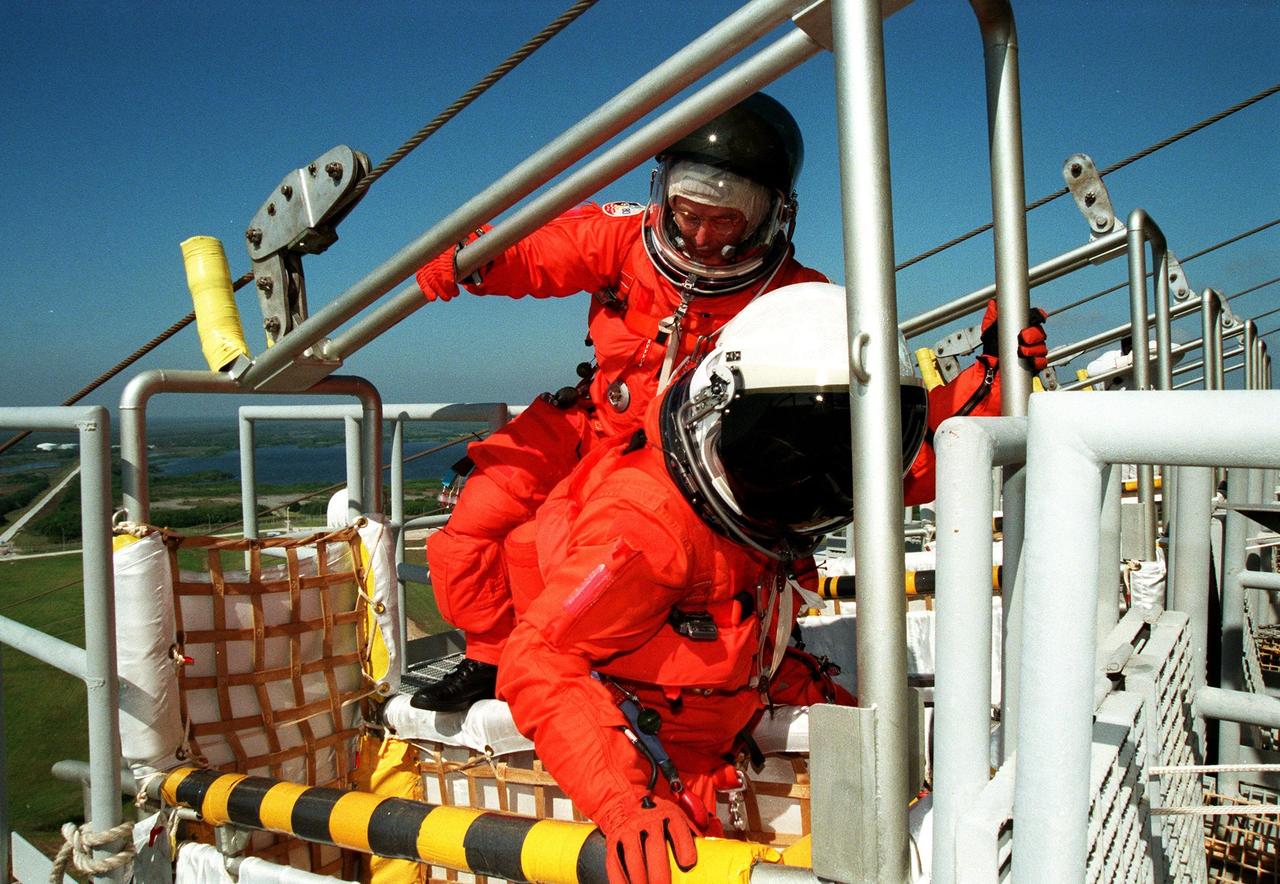
KENNEDY SPACE CENTER, Fla. -- STS-88 Mission Specialist Jerry L. Ross (left) climbs into slideware basket behind Mission Specialist Nancy Jane Currie, Ph.D., (right) at Launch Pad 39A as part of an emergency egress exercise. The crew are at KSC to participate in the Terminal Countdown Demonstration Test (TCDT) which includes mission familiarization activities, emergency egress training, and the simulated main engine cut-off exercise. Mission STS-88 is targeted for launch on Dec. 3, 1998. It is the first U.S. flight for the assembly of the International Space Station and will carry the Unity connecting module. Unity will be mated with the already orbiting Russian-built Zarya control module. The 12-day mission includes three planned spacewalks to connect power, data and utility lines and install exterior equipment
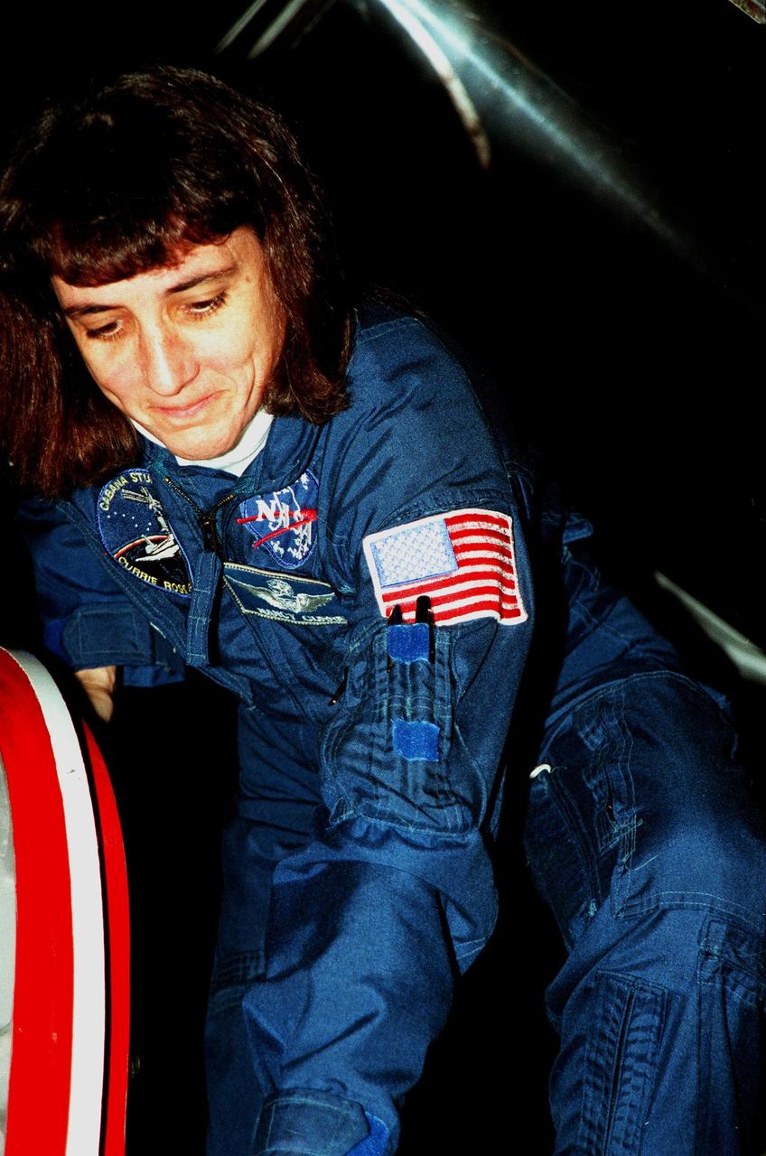
STS-88 Mission Specialist Nancy J. Currie climbs out of a T-38 jet aircraft in which she arrived after dark at the Shuttle Landing Facility in order to take part in Terminal Countdown Demonstration Test (TCDT) activities. The TCDT provides the crew with simulated countdown exercises, emergency egress training, and opportunities to inspect their mission payloads in the orbiter's payload bay. Mission STS-88 is targeted for launch on Dec. 3, 1998. It is the first U.S. flight for the assembly of the International Space Station and will carry the Unity connecting module. Others in the STS-88 crew are Mission Commander Robert D. Cabana, Pilot Frederick W. "Rick" Sturckow, Mission Specialists Jerry L. Ross, James H. Newman and Sergei Krikalev, a Russian cosmonaut. Ross and Newman will make three spacewalks to connect power, data and utility lines and install exterior equipment
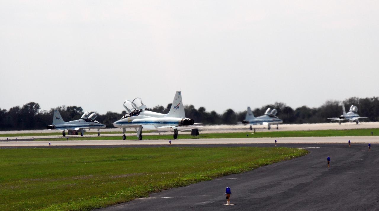
KENNEDY SPACE CENTER, FLA. -- At the NASA Kennedy Space Center's Shuttle Landing Facility, the jet aircraft carrying STS-123 crewmembers line up for takeoff on the return trip to Houston. The STS-123 crew took part in a terminal countdown demonstration test, or TCDT, in preparation for the launch of space shuttle Endeavour scheduled on March 11. The TCDT enables astronauts and ground crews to participate in various countdown activities, including equipment familiarization and emergency egress training. On the STS-123 mission, Endeavour and its crew will deliver the first section of the Japan Aerospace Exploration Agency's Kibo laboratory and the Canadian Space Agency's two-armed robotic system, Dextre Photo credit: NASA/Kim Shiflett
KENNEDY SPACE CENTER, Fla. -- STS-88 Mission Specialists Sergei Konstantinovich Krikalev (left) and James H. Newman (right) are ready to leave Launch Pad 39A in the slidewire basket during an emergency egress exercise. The crew are at KSC to participate in the Terminal Countdown Demonstration Test (TCDT) which includes mission familiarization activities, emergency egress training, and the simulated main engine cut-off exercise. Mission STS-88 is targeted for launch on Dec. 3, 1998. It is the first U.S. flight for the assembly of the International Space Station and will carry the Unity connecting module. Unity will be mated with the already orbiting Russian-built Zarya control module. The 12-day mission includes three planned spacewalks to connect power, data and utility lines and install exterior equipment
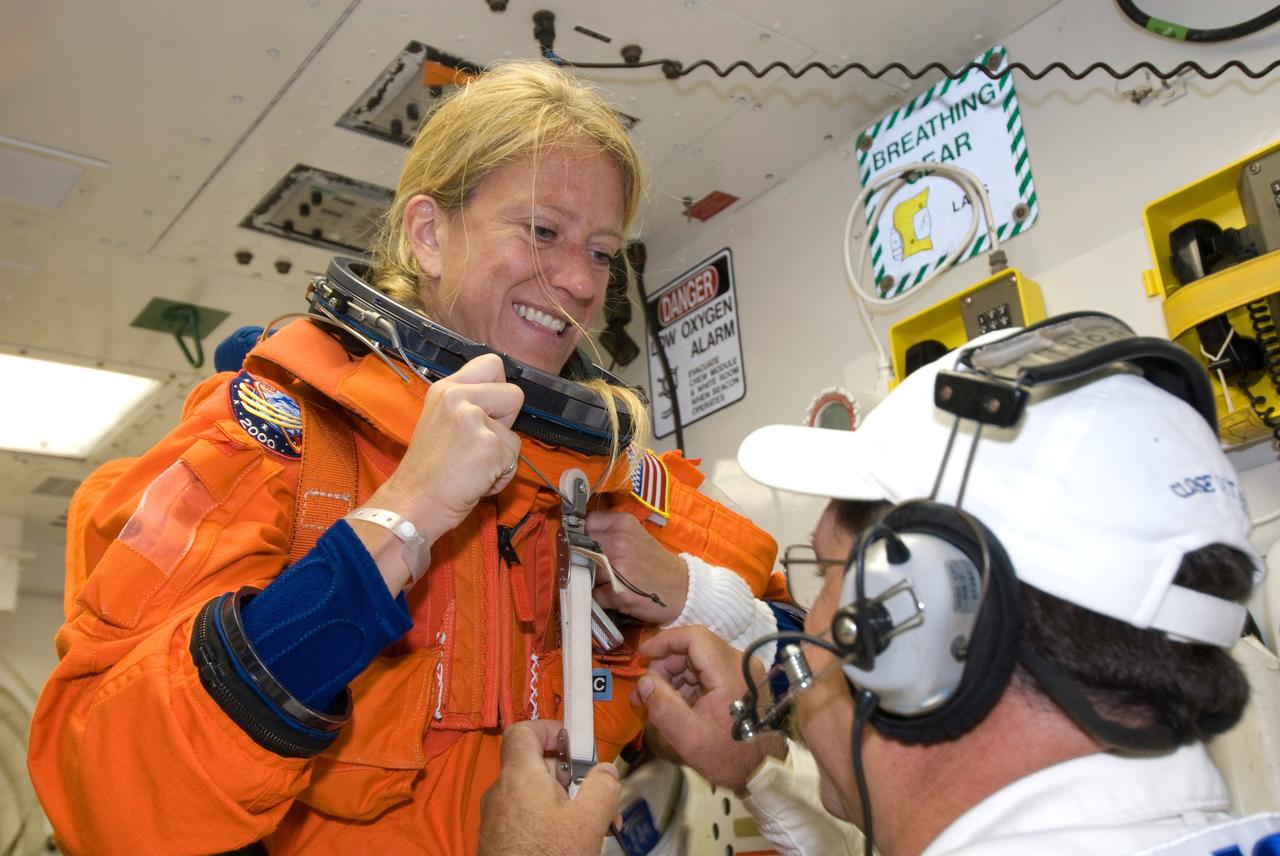
CAPE CANAVERAL, Fla. -- In the White Room on Launch Pad 39A at NASA's Kennedy Space Center, STS-124 Mission Specialist Karen Nyberg chats with one of the closeout crew who is helping her don the equipment required for launch. She and the other crew members are taking part in a simulated launch countdown, part of the launch dress rehearsal known as the terminal countdown demonstration test. The simulation serves as a practice exercise in which both the launch team and flight crew rehearse launch day time lines and procedures. The test culminates in a simulated ignition and automated shutdown of the orbiter's main engines. On the STS-124 mission, the crew will deliver and install the Japanese Experiment Module – Pressurized Module and Japanese Remote Manipulator System. Discovery's launch is targeted for May 31. Photo credit: NASA/Amanda Diller
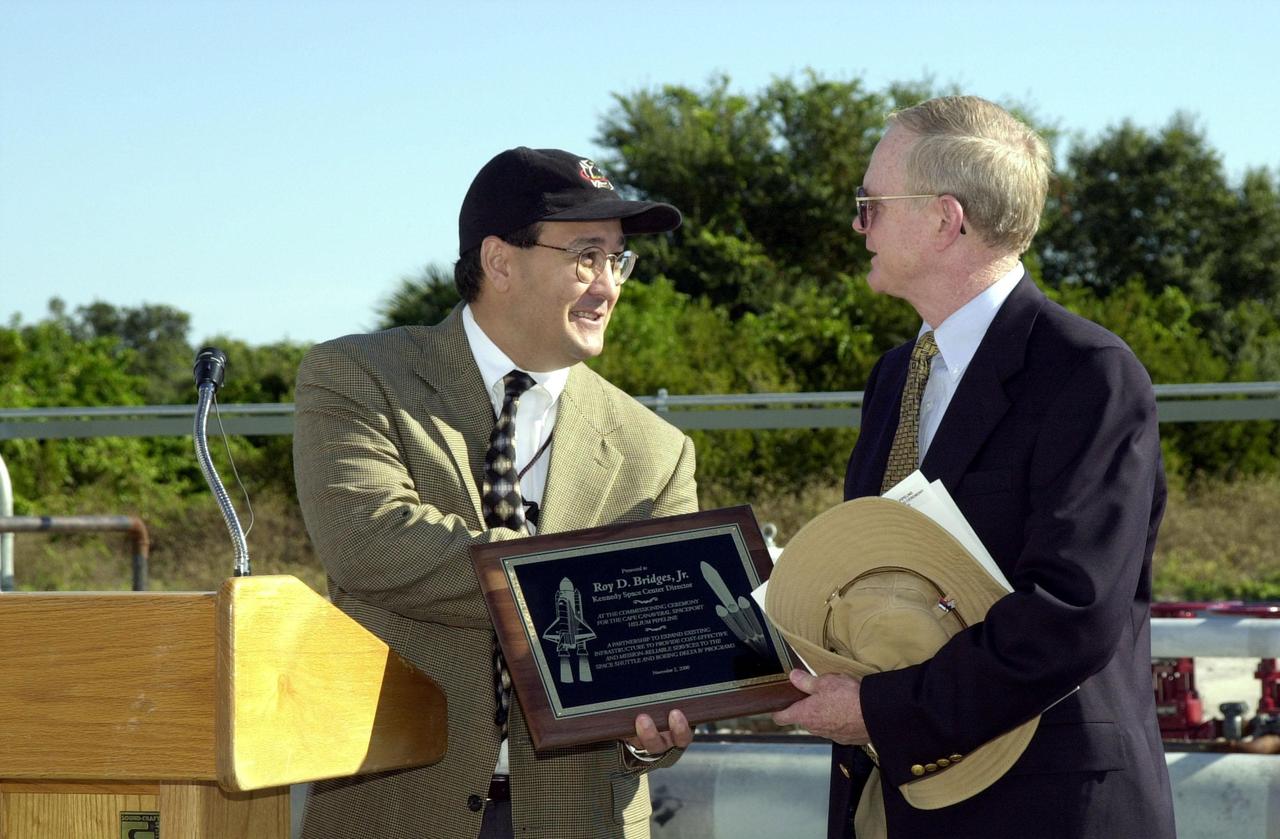
At the commissioning of a new high-pressure helium pipeline at Kennedy Space Center, Ramon Lugo, acting executive director, JPMO , presents a plaque to Center Director Roy Bridges. The pipeline will service launch needs at the new Delta IV Complex 37 at Cape Canaveral Air Force Station. Others at the ceremony were Jerry Jorgensen, pipeline project manager, Space Gateway Support (SGS); Col. Samuel Dick, representative of the 45th Space Wing; David Herst, director, Delta IV Launch Sites; Pierre Dufour, president and CEO, Air Liquide America Corporation; and Michael Butchko, president, SGS. The nine-mile-long buried pipeline will also serve as a backup helium resource for Shuttle launches. Nearly one launch’s worth of helium will be available in the pipeline to support a Shuttle pad in an emergency. The line originates at the Helium Facility on KSC and terminates in a meter station at the perimeter of the Delta IV launch pad
This high-resolution swat of Pluto sweeps over the cratered plains at the west of the New Horizons' encounter hemisphere and across numerous prominent faults, skimming the eastern margin of the dark, forbidding region informally known as Cthulhu Regio, and finally passing over the mysterious, possibly cryovolcanic edifice Wright Mons, before reaching the terminator or day-night line. Among the many notable details shown are the overlapping and infilling relationships between units of the relatively smooth, bright volatile ices from Sputnik Planum (at the edge of the mosaic) and the dark edge or "shore" of Cthulhu. The pictures in this mosaic were taken by the Long Range Reconnaissance Imager (LORRI) in "ride-along" mode with the LEISA spectrometer, which accounts for the 'zigzag' or step pattern. Taken shortly before New Horizons' July 14 closest approach to Pluto, details as small as 500 yards (500 meters) can be seen. http://photojournal.jpl.nasa.gov/catalog/PIA20286
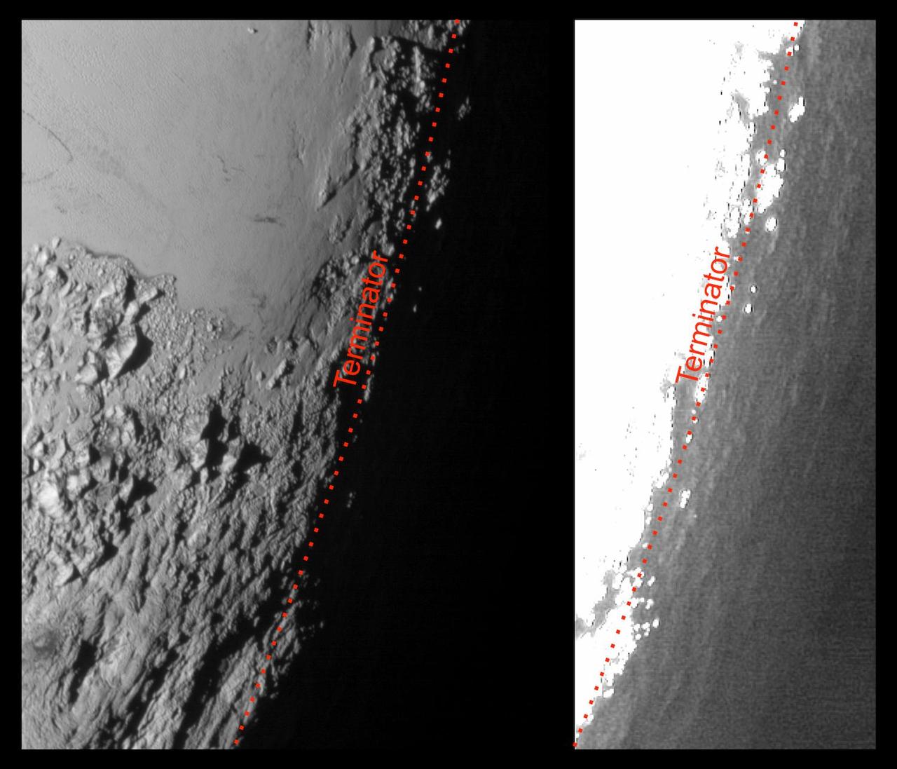
This image of Pluto from NASA's New Horizons spacecraft, processed in two different ways, shows how Pluto's bright, high-altitude atmospheric haze produces a twilight that softly illuminates the surface before sunrise and after sunset, allowing the sensitive cameras on New Horizons to see details in nighttime regions that would otherwise be invisible. The right-hand version of the image has been greatly brightened to bring out faint details of rugged haze-lit topography beyond Pluto's terminator, which is the line separating day and night. The image was taken as New Horizons flew past Pluto on July 14, 2015, from a distance of 50,000 miles (80,000 kilometers). http://photojournal.jpl.nasa.gov/catalog/PIA19931

At the commissioning of a new high-pressure helium pipeline at Kennedy Space Center, Ramon Lugo, acting executive director, JPMO , presents a plaque to Center Director Roy Bridges. The pipeline will service launch needs at the new Delta IV Complex 37 at Cape Canaveral Air Force Station. Others at the ceremony were Jerry Jorgensen, pipeline project manager, Space Gateway Support (SGS); Col. Samuel Dick, representative of the 45th Space Wing; David Herst, director, Delta IV Launch Sites; Pierre Dufour, president and CEO, Air Liquide America Corporation; and Michael Butchko, president, SGS. The nine-mile-long buried pipeline will also serve as a backup helium resource for Shuttle launches. Nearly one launch’s worth of helium will be available in the pipeline to support a Shuttle pad in an emergency. The line originates at the Helium Facility on KSC and terminates in a meter station at the perimeter of the Delta IV launch pad

Jerry Jorgensen welcomes the audience to the commissioning of a new high-pressure helium pipeline at Kennedy Space Center. Jorgensen, with Space Gateway Support (SGS), is the pipeline project manager. To the right is Ramon Lugo, acting executive director, JPMO. Others at the ceremony were Center Director Roy Bridges; Col. Samuel Dick, representative of the 45th Space Wing; David Herst, director, Delta IV Launch Sites; Pierre Dufour, president and CEO, Air Liquide America Corporation; and Michael Butchko, president, SGS. The pipeline will service launch needs at the new Delta IV Complex 37 at Cape Canaveral Air Force Station. The nine-mile-long buried pipeline will also serve as a backup helium resource for Shuttle launches. Nearly one launch’s worth of helium will be available in the pipeline to support a Shuttle pad in an emergency. The line originates at the Helium Facility on KSC and terminates in a meter station at the perimeter of the Delta IV launch pad

STS-88 Mission Specialist James H. Newman gives a thumbs up on his nighttime arrival at the Shuttle Landing Facility in a T-38 jet aircraft to take part in Terminal Countdown Demonstration Test (TCDT) activities. The TCDT provides the crew with simulated countdown exercises, emergency egress training, and opportunities to inspect their mission payloads in the orbiter's payload bay. Mission STS-88 is targeted for launch on Dec. 3, 1998. It is the first U.S. flight for the assembly of the International Space Station and will carry the Unity connecting module. Others in the STS-88 crew are Mission Commander Robert D. Cabana, Pilot Frederick W. "Rick" Sturckow, Mission Specialists Nancy J. Currie, Jerry L. Ross, and Sergei Krikalev, a Russian cosmonaut. Ross and Newman will make three spacewalks to connect power, data and utility lines and install exterior equipment
CAPE CANAVERAL, Fla. - The STS-125 crew lines up outside the Astrovan after suiting up in the Operations and Checkout Building at NASA's Kennedy Space Center in Florida. From left are Mission Specialists Michael Good, Mike Massimino, Andrew Feustel, John Grunsfeld and Megan McArthur, Pilot Gregory C. Johnson and Commander Scott Altman. The crew is heading for Launch Pad 39A where they will take part in a simulated launch countdown aboard space shuttle Atlantis. The countdown is the culmination of terminal countdown demonstration test, or TCDT, activities as preparation before launch. TCDT provides astronauts and ground crews with an opportunity to participate in various simulated countdown activities, including equipment familiarization, emergency training and the countdown. Atlantis’ STS-125 mission to service NASA’s Hubble Space Telescope is targeted for launch Oct. 14. Photo credit: NASA/Kim Shiflett
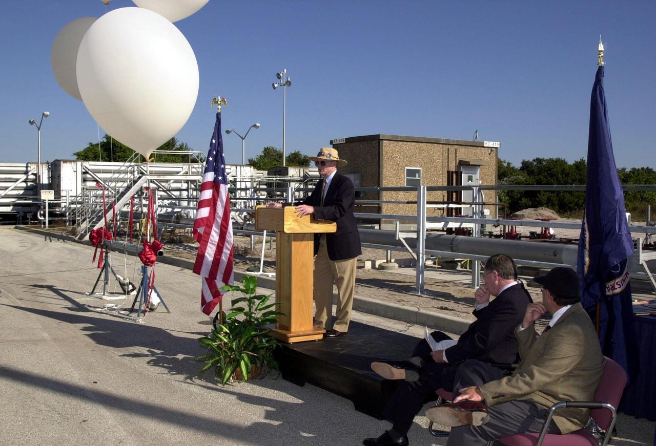
Center Director Roy Bridges addresses the audience at the commissioning of a new high-pressure helium pipeline at Kennedy Space Center that will service launch needs at the new Delta IV Complex 37 at Cape Canaveral Air Force Station. The nine-mile-long buried pipeline will also serve as a backup helium resource for Shuttle launches. Nearly one launch’s worth of helium will be available in the pipeline to support a Shuttle pad in an emergency. The line originates at the Helium Facility on KSC and terminates in a meter station at the perimeter of the Delta IV launch pad. Others at the ceremony were Jerry Jorgensen, pipeline project manager, Space Gateway Support (SGS); Col. Samuel Dick, representative of the 45th Space Wing; Ramon Lugo, acting executive director, JPMO; David Herst, director, Delta IV Launch Sites; Pierre Dufour, president and CEO, Air Liquide America Corporation; and Michael Butchko, president, SGS
KENNEDY SPACE CENTER, Fla. -- STS-88 Mission Specialists James H. Newman (left) and Sergei Konstantinovich Krikalev (right) hurry toward the slidewire basket at the 195-foot level of Launch Pad 39A during an emergency egress exercise. The crew are at KSC to participate in the Terminal Countdown Demonstration Test (TCDT) which includes mission familiarization activities, emergency egress training, and the simulated main engine cut-off exercise. Mission STS-88 is targeted for launch on Dec. 3, 1998. It is the first U.S. flight for the assembly of the International Space Station and will carry the Unity connecting module. Unity will be mated with the already orbiting Russian-built Zarya control module. The 12-day mission includes three planned spacewalks to connect power, data and utility lines and install exterior equipment

CAPE CANAVERAL, Fla. -- In the White Room on Launch Pad 39A at NASA's Kennedy Space Center, STS-124 Commander Mark Kelly dons the parachute required for launch. He and the other crew members are taking part in a simulated launch countdown, part of the launch dress rehearsal known as the terminal countdown demonstration test. The simulation serves as a practice exercise in which both the launch team and flight crew rehearse launch day time lines and procedures. The test culminates in a simulated ignition and automated shutdown of the orbiter's main engines. On the STS-124 mission, the crew will deliver and install the Japanese Experiment Module – Pressurized Module and Japanese Remote Manipulator System. Discovery's launch is targeted for May 31. Photo credit: NASA/Amanda Diller
This image provides a close-up view of Jupiter's southern hemisphere, as seen by NASA's Juno spacecraft on August 27, 2016. The JunoCam instrument captured this image with its red spectral filter when the spacecraft was about 23,600 miles (38,000 kilometers) above the cloud tops. The image covers an area from close to the south pole to 20 degrees south of the equator, centered on a longitude at about 140 degrees west. The transition between the banded structures near the equator and the more chaotic polar region (south of about 65 degrees south latitude) can be clearly seen. The smaller version at right of this image shows the same view with a latitude/longitude grid overlaid. This image has been processed to remove shading effects near the terminator -- the dividing line between day and night -- caused by Juno's orbit. http://photojournal.jpl.nasa.gov/catalog/PIA21035

STS-88 Mission Commander Robert D. Cabana arrives after dark at the Shuttle Landing Facility in a T-38 jet aircraft to take part in Terminal Countdown Demonstration Test (TCDT) activities. The TCDT provides the crew with simulated countdown exercises, emergency egress training, and opportunities to inspect their mission payloads in the orbiter's payload bay. Mission STS-88 is targeted for launch on Dec. 3, 1998. It is the first U.S. flight for the assembly of the International Space Station and will carry the Unity connecting module. Others in the STS-88 crew are Pilot Frederick W. "Rick" Sturckow, Mission Specialists Nancy J. Currie, Jerry L. Ross, James H. Newman and Russian cosmonaut Sergei Konstantinovich Krikalev. Ross and Newman will make three spacewalks to connect power, data and utility lines and install exterior equipment

STS-88 Mission Specialist Jerry L. Ross arrives after dark at the Shuttle Landing Facility to take part in Terminal Countdown Demonstration Test (TCDT) activities. The TCDT provides the crew with simulated countdown exercises, emergency egress training, and opportunities to inspect their mission payloads in the orbiter's payload bay. Mission STS-88 is targeted for launch on Dec. 3, 1998. It is the first U.S. flight for the assembly of the International Space Station and will carry the Unity connecting module. Others in the STS-88 crew are Commander Robert D. Cabana, Pilot Frederick W. "Rick" Sturckow, Mission Specialists Nancy J. Currie and James H. Newman and Russian cosmonaut Sergei Konstantinovich Krikalev. Ross and Newman will make three spacewalks to connect power, data and utility lines and install exterior equipment
STS-88 Pilot Frederick W. "Rick" Sturckow arrives after dark at the Shuttle Landing Facility in a T-38 jet aircraft to take part in Terminal Countdown Demonstration Test (TCDT) activities. The TCDT provides the crew with simulated countdown exercises, emergency egress training, and opportunities to inspect their mission payloads in the orbiter's payload bay. Mission STS-88 is targeted for launch on Dec. 3, 1998. It is the first U.S. flight for the assembly of the International Space Station and will carry the Unity connecting module. Others in the STS-88 crew are Mission Commander Robert D. Cabana, Mission Specialists Nancy J. Currie, Jerry L. Ross, James H. Newman and Sergei Krikalev, a Russian cosmonaut. Ross and Newman will make three spacewalks to connect power, data and utility lines and install exterior equipment

Center Director Roy Bridges addresses the audience at the commissioning of a new high-pressure helium pipeline at Kennedy Space Center that will service launch needs at the new Delta IV Complex 37 at Cape Canaveral Air Force Station. The nine-mile-long buried pipeline will also serve as a backup helium resource for Shuttle launches. Nearly one launch’s worth of helium will be available in the pipeline to support a Shuttle pad in an emergency. The line originates at the Helium Facility on KSC and terminates in a meter station at the perimeter of the Delta IV launch pad. Others at the ceremony were Jerry Jorgensen, pipeline project manager, Space Gateway Support (SGS); Col. Samuel Dick, representative of the 45th Space Wing; Ramon Lugo, acting executive director, JPMO; David Herst, director, Delta IV Launch Sites; Pierre Dufour, president and CEO, Air Liquide America Corporation; and Michael Butchko, president, SGS
KENNEDY SPACE CENTER, Fla. -- STS-88 Mission Commander Robert D. Cabana (left) and Pilot Frederick W. "Rick" Sturckow (right) are ready to leave Launch Pad 39A in the slidewire basket during an emergency egress exercise. Other crew members watch from behind. The crew are at KSC to participate in the Terminal Countdown Demonstration Test (TCDT) which includes mission familiarization activities, emergency egress training, and the simulated main engine cut-off exercise. Mission STS-88 is targeted for launch on Dec. 3, 1998. It is the first U.S. flight for the assembly of the International Space Station and will carry the Unity connecting module. Unity will be mated with the already orbiting Russian-built Zarya control module. The 12-day mission includes three planned spacewalks to connect power, data and utility lines and install exterior equipment
KENNEDY SPACE CENTER, Fla. -- On Launch Pad 39A, the STS-88 crew pose after successfully completing a pre-launch countdown exercise as part of Terminal Countdown Demonstration Test. From left, they are Mission Specialist James H. Newman, Pilot Frederick W. "Rick" Sturckow, Mission Commander Robert D. Cabana, and Mission Specialists Nancy J. Currie, Ph.D., Jerry L. Ross and Sergei Konstantinovich Krikalev, a Russian cosmonaut. Mission STS-88 is targeted for launch on Dec. 3, 1998. It is the first U.S. flight for the assembly of the International Space Station and will carry the Unity connecting module. Unity will be mated with the already orbiting Russian-built Zarya control module. The 12-day mission includes three planned spacewalks to connect power, data and utility lines and install exterior equipment

Juno's Radiation Monitoring Investigation used the Stellar Reference Unit (SRU) star camera to collect this high-resolution image of the dark side of Jupiter during Perijove 11 on Feb. 7, 2018. The clouds are illuminated by moonlight from Jupiter's moon Io and the two bright spots on the right side of the image are flashes of Jovian lightning. Juno was only 41,000 miles (66,000 kilometers) from the cloud tops when this SRU image was collected. The left side of the composite image shows a 3-dimensional visualization of Jupiter's Northern hemisphere with its northern aurora included. To the right of the aurora and solar terminator line, is a box illustrating the position of the SRU field of view at the time the image was taken. Further to the right is an exploded view of the SRU image. https://photojournal.jpl.nasa.gov/catalog/PIA22965
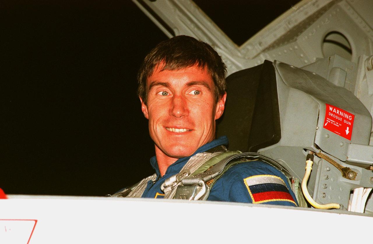
STS-88 Mission Specialist Sergei Krikalev, a Russian cosmonaut, arrives after dark at the Shuttle Landing Facility in a T-38 jet aircraft to take part in Terminal Countdown Demonstration Test (TCDT) activities. The TCDT provides the crew with simulated countdown exercises, emergency egress training, and opportunities to inspect their mission payloads in the orbiter's payload bay. Mission STS-88 is targeted for launch on Dec. 3, 1998. It is the first U.S. flight for the assembly of the International Space Station and will carry the Unity connecting module. Others in the STS-88 crew are Mission Commander Robert D. Cabana, Pilot Frederick W. "Rick" Sturckow, Mission Specialists Nancy J. Currie, Jerry L. Ross, and James H. Newman. Ross and Newman will make three spacewalks to connect power, data and utility lines and install exterior equipment

CAPE CANAVERAL, Fla. -- In the White Room on Launch Pad 39A at NASA's Kennedy Space Center, STS-124 Mission Specialist Akihiko Hoshide adjusts his parachute required for launch. Hoshide represents the Japan Aerospace Exploration Agency. Behind him is Mission Specialist Karen Nyberg. They and the other crew members are taking part in a simulated launch countdown, part of the launch dress rehearsal known as the terminal countdown demonstration test. The simulation serves as a practice exercise in which both the launch team and flight crew rehearse launch day time lines and procedures. The test culminates in a simulated ignition and automated shutdown of the orbiter's main engines. On the STS-124 mission, the crew will deliver and install the Japanese Experiment Module – Pressurized Module and Japanese Remote Manipulator System. Discovery's launch is targeted for May 31. Photo credit: NASA/Amanda Diller
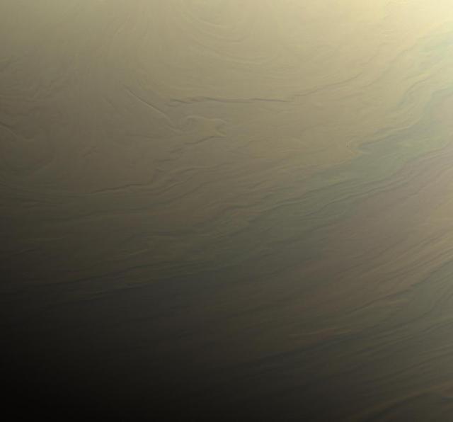
NASA's Cassini spacecraft gazed toward the northern hemisphere of Saturn to spy subtle, multi-hued bands in the clouds there. This view looks toward the terminator -- the dividing line between night and day -- at lower left. The sun shines at low angles along this boundary, in places highlighting vertical structure in the clouds. Some vertical relief is apparent in this view, with higher clouds casting shadows over those at lower altitude. Images taken with the Cassini spacecraft narrow-angle camera using red, green and blue spectral filters were combined to create this natural-color view. The images were acquired on Aug. 31, 2017, at a distance of approximately 700,000 miles (1.1 million kilometers) from Saturn. Image scale is about 4 miles (6 kilometers) per pixel. https://photojournal.jpl.nasa.gov/catalog/PIA21888
CAPE CANAVERAL, Fla. -- In the White Room on Launch Pad 39A at NASA's Kennedy Space Center, STS-124 Mission Specialist Karen Nyberg is helped getting into the parachute required for launch. She and the other crew members are taking part in a simulated launch countdown, part of the launch dress rehearsal known as the terminal countdown demonstration test. The simulation serves as a practice exercise in which both the launch team and flight crew rehearse launch day time lines and procedures. The test culminates in a simulated ignition and automated shutdown of the orbiter's main engines. On the STS-124 mission, the crew will deliver and install the Japanese Experiment Module – Pressurized Module and Japanese Remote Manipulator System. Discovery's launch is targeted for May 31. Photo credit: NASA/Amanda Diller
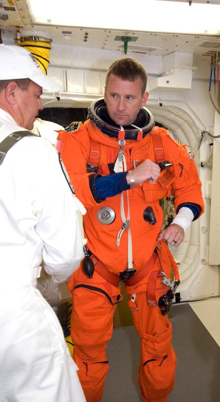
CAPE CANAVERAL, Fla. -- In the White Room on Launch Pad 39A at NASA's Kennedy Space Center, STS-124 Pilot Ken Ham secures the parachute required for launch. He and the other crew members are taking part in a simulated launch countdown, part of the launch dress rehearsal known as the terminal countdown demonstration test. The simulation serves as a practice exercise in which both the launch team and flight crew rehearse launch day time lines and procedures. The test culminates in a simulated ignition and automated shutdown of the orbiter's main engines. On the STS-124 mission, the crew will deliver and install the Japanese Experiment Module – Pressurized Module and Japanese Remote Manipulator System. Discovery's launch is targeted for May 31. Photo credit: NASA/Amanda Diller
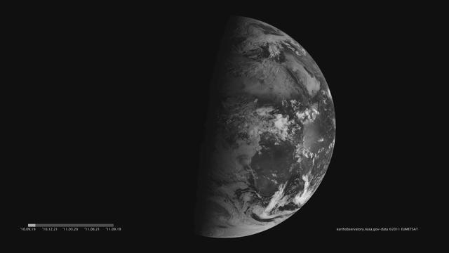
Images acquired December 21, 2010 - September 20, 2011. To download the high res and learn more go to: <a href="http://earthobservatory.nasa.gov/IOTD/view.php?id=52248" rel="nofollow">earthobservatory.nasa.gov/IOTD/view.php?id=52248</a> One of the most frequently misunderstood concepts in science is the reason for Earth’s seasons. As we experience the September equinox today—anyone try to balance an egg yet?—we thought we’d offer a space-based view of what’s going on. Around 6 a.m. local time each day, the Sun, Earth, and any geosynchronous satellite form a right angle, affording a nadir (straight down) view of the terminator, where the shadows of nightfall meet the sunlight of dusk and dawn. The shape of this line between night and day varies with the seasons, which means different lengths of days and differing amounts of warming sunshine. (The line is actually a curve because the Earth is round, but satellite images only show it in two-dimensions.) The Spinning Enhanced Visible and Infrared Imager (SEVIRI) on EUMETSAT's Meteosat-9 captured these four views of the day-night terminator on December 21, 2010, and March 20, June 21, and September 20, 2011. Each image was taken at 6:12 a.m. local time. On March 20 and September 20, the terminator is a straight north-south line, and the Sun is said to sit directly above the equator. On December 21, the Sun resides directly over the Tropic of Capricorn when viewed from the ground, and sunlight spreads over more of the Southern Hemisphere. On June 21, the Sun sits above the Tropic of Cancer, spreading more sunlight in the north and turning the tables on the south. The bulge of our spherical Earth blocks sunlight from the far hemisphere at the solstices; that same curvature allows the Sun’s rays to spread over more area near the top and bottom of the globe. Of course, it is not the Sun that is moving north or south through the seasons, but a change in the orientation and angles between the Earth and its nearest star. The axis of the Earth is tilted 23.5 degrees relative to the Sun and the ecliptic plane. The axis is tilted away from the Sun at the December solstice and toward the Sun at the June solstice, spreading more and less light on each hemisphere. At the equinoxes, the tilt is at a right angle to the Sun and the light is spread evenly. The equinox and changing of the seasons occurs on September 23, 2011 at 9:05 a.m. Universal Time. (Our September image above is a few days early.) Equinox means "equal night" in Latin, capturing the idea that daytime and nighttime are equal lengths everywhere on the planet. That is true of the Sun's presence above the horizon, though it does not account for twilight, when the Sun's rays extend from beyond the horizon to illuminate our gas-filled atmosphere. <b>NASA images and animation by Robert Simmon, using data ©2010 EUMETSAT. Caption by Mike Carlowicz.</b> Instrument: Meteosat Credit: <b><a href="http://www.earthobservatory.nasa.gov/" rel="nofollow"> NASA Earth Observatory</a></b> <b><a href="http://www.nasa.gov/audience/formedia/features/MP_Photo_Guidelines.html" rel="nofollow">NASA image use policy.</a></b> <b><a href="http://www.nasa.gov/centers/goddard/home/index.html" rel="nofollow">NASA Goddard Space Flight Center</a></b> enables NASA’s mission through four scientific endeavors: Earth Science, Heliophysics, Solar System Exploration, and Astrophysics. Goddard plays a leading role in NASA’s accomplishments by contributing compelling scientific knowledge to advance the Agency’s mission. <b>Follow us on <a href="http://twitter.com/NASAGoddardPix" rel="nofollow">Twitter</a></b> <b>Like us on <a href="http://www.facebook.com/pages/Greenbelt-MD/NASA-Goddard/395013845897?ref=tsd" rel="nofollow">Facebook</a></b> <b>Find us on <a href="http://instagrid.me/nasagoddard/?vm=grid" rel="nofollow">Instagram</a></b>
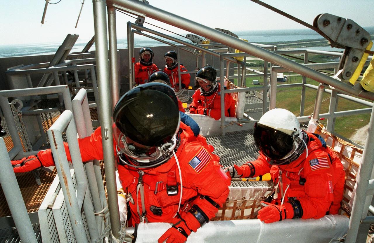
KENNEDY SPACE CENTER, FLA. -- The STS-120 crew is at NASA's Kennedy Space Center for the pre-launch terminal countdown demonstration test, or TCDT. During emergency egress training, the crew gets instructions about what to do when the slidewire baskets (at right) reach the landing site. In the foreground is Commander Pamela Melroy; lined up behind her are Pilot George Zamka and Mission Specialists Daniel Tani, Scott Parazynski, Stephanie Wilson, Doug Wheelock and Paolo Nespoli, who represents the European Space Agency. After the mission, Tani will remain aboard the International Space Station and return with the STS-122 crew, targeted to launch Dec. 6. The TCDT provides astronauts and ground crews an opportunity to participate in various simulated countdown activities, including equipment familiarization and emergency training. The STS-120 mission will deliver the U.S. Node 2 module, named Harmony, aboard space shuttle Discovery to the International Space Station. Launch of Discovery on mission STS-120 is targeted for Oct. 23 at 11:38 a.m. EDT on a 14-day mission. Photo credit: NASA/Kim Shiflett
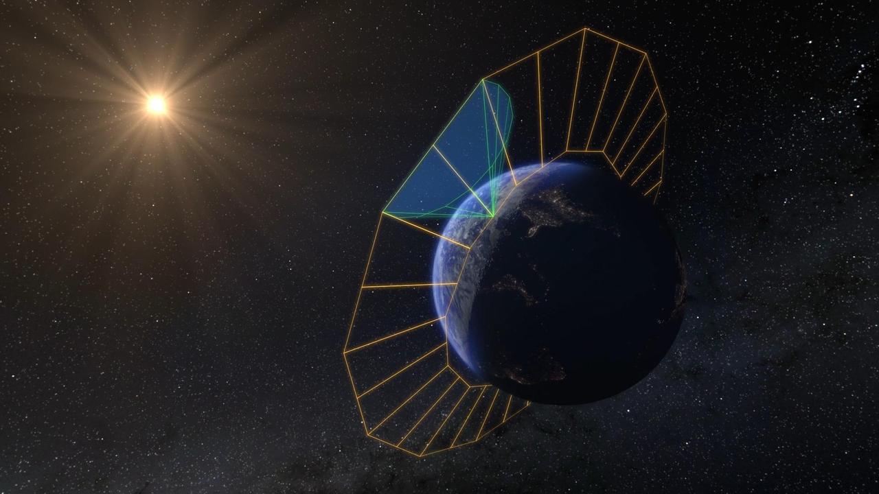
NASA's SPHEREx mission will create the first all-sky spectroscopic survey in the near-infrared, detecting hundreds of millions of stars and galaxies. To do this, the SPHEREx space telescope will look outward from low-Earth orbit, circling the planet along its day-night (or terminator) line. This artist's concept depicts the spacecraft's orbital plane in orange, and its field of view in green. Each of the telescope's orbits allows it to image a 360-degree strip of the celestial sky. As Earth's orbit around the Sun progresses, that strip slowly advances, enabling SPHEREx to complete four all-sky maps in two years. Short for Spectro-Photometer for the History of the Universe, Epoch of Reionization and Ices Explorer, SPHEREx will create a map of the cosmos like no other. Using a technique called spectroscopy to image the entire sky in 102 wavelengths of infrared light, SPHEREx will gather information about the composition of and distance to millions of galaxies and stars. With this map, scientists will study what happened in the first fraction of a second after the big bang, how galaxies formed and evolved, and the origins of water in planetary systems in our galaxy. https://photojournal.jpl.nasa.gov/catalog/PIA26532
CAPE CANAVERAL, Fla. - At the Operations and Checkout Building at NASA's Kennedy Space Center in Florida, the members of the STS-129 crew line up beside the Astrovan for a portrait in their launch-and-entry suits. The six astronauts for space shuttle Atlantis’ STS-129 mission are en route to their launch dress rehearsal, the Terminal Countdown Demonstration Test, at Launch Pad 39A. From left are Mission Specialists Robert L. Satcher Jr., Mike Foreman, Randy Bresnik and Leland Melvin; Pilot Barry E. Wilmore; and Commander Charles O. Hobaugh. Additional training associated with the test was done last month, but the simulated countdown was postponed because of a scheduling conflict with the launch of NASA’s Ares I-X test rocket. Launch of Atlantis on its STS-129 mission to the International Space Station is set for Nov. 16. On STS-129, the crew will deliver to the station two spare gyroscopes, two nitrogen tank assemblies, two pump modules, an ammonia tank assembly and a spare latching end effector for the station's robotic arm. For information on the STS-129 crew and mission objectives, visit http://www.nasa.gov/mission_pages/shuttle/shuttlemissions/sts129/index.html. Photo credit: NASA/Kim Shiflett
The north polar region of Jupiter's volcanic moon Io was captured by the JunoCam imager aboard NASA's Juno during the spacecraft's 57th close pass of the gas giant on Dec. 30, 2023. The region was imaged at a scale of 1.1 miles (1.8 kilometers) per pixel. The low illumination angle along the terminator (the line dividing day and night) shows several previously unrecognized mountain blocks rising abruptly above the surrounding plains. These are each characterized by a central, sharp peak and adjacent flanks that appear to be collapsing toward the plains. The higher of these peaks range from 2.3 to 6.1 miles (3.7 to 9.8 kilometers) in elevation. The shadows indicate that some of the mountain flanks grade into plateaus under 0.6 miles (1 kilometer). All mountains here are partly or completely covered by bright white diffuse deposits, which may be sulfur dioxide frosts derived from gases escaping the interior and transported up. Extremely large flow fields are evident here. The most active flow regions in Lei-Kung Fluctus (upper left in this image) are evidenced by their darker color and surrounded by white deposits, perhaps liberated from the surface by thermal action. https://photojournal.jpl.nasa.gov/catalog/PIA26484

Jerry Jorgensen, pipeline project manager, Space Gateway Support (SGS) presents an award of appreciation to H.T. Everett, KSC Propellants manager, at the commissioning of a new high-pressure helium pipeline at Kennedy Space Center. The pipeline will service launch needs at the new Delta IV Complex 37 at Cape Canaveral Air Force Station. The nine-mile-long buried pipeline will also serve as a backup helium resource for Shuttle launches. Nearly one launch’s worth of helium will be available in the pipeline to support a Shuttle pad in an emergency. The line originates at the Helium Facility on KSC and terminates in a meter station at the perimeter of the Delta IV launch pad. Others at the ceremony were Center Director Roy Bridges;); Col. Samuel Dick, representative of the 45th Space Wing; Ramon Lugo, acting executive director, JPMO; David Herst, director, Delta IV Launch Sites; Pierre Dufour, president and CEO, Air Liquide America Corporation; and Michael Butchko, president, SGS
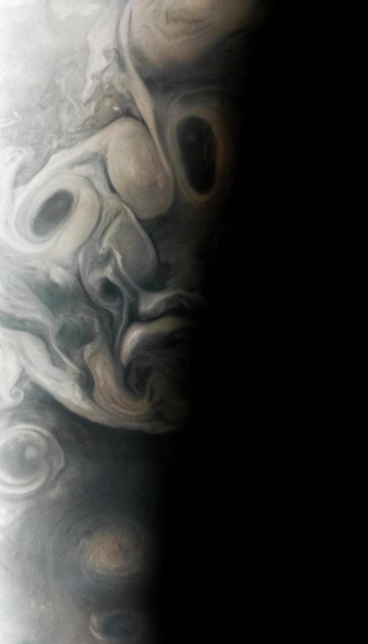
On Sept. 7, 2023, during its 54th close flyby of Jupiter, NASA's Juno mission captured this view of an area in the giant planet's far northern regions called Jet N7. The image shows turbulent clouds and storms along Jupiter's terminator, the dividing line between the day and night sides of the planet. The low angle of sunlight highlights the complex topography of features in this region, which scientists have studied to better understand the processes playing out in Jupiter's atmosphere. As often occurs in views from Juno, Jupiter's clouds in this picture lend themselves to pareidolia, the effect that causes observers to perceive faces or other patterns in largely random patterns. Citizen scientist Vladimir Tarasov made this image using raw data from the JunoCam instrument. At the time the raw image was taken, the Juno spacecraft was about 4,800 miles (about 7,700 kilometers) above Jupiter's cloud tops, at a latitude of about 69 degrees north. https://photojournal.jpl.nasa.gov/catalog/PIA25727

Jerry Jorgensen, pipeline project manager, Space Gateway Support (SGS) presents an award of appreciation to H.T. Everett, KSC Propellants manager, at the commissioning of a new high-pressure helium pipeline at Kennedy Space Center. The pipeline will service launch needs at the new Delta IV Complex 37 at Cape Canaveral Air Force Station. The nine-mile-long buried pipeline will also serve as a backup helium resource for Shuttle launches. Nearly one launch’s worth of helium will be available in the pipeline to support a Shuttle pad in an emergency. The line originates at the Helium Facility on KSC and terminates in a meter station at the perimeter of the Delta IV launch pad. Others at the ceremony were Center Director Roy Bridges;); Col. Samuel Dick, representative of the 45th Space Wing; Ramon Lugo, acting executive director, JPMO; David Herst, director, Delta IV Launch Sites; Pierre Dufour, president and CEO, Air Liquide America Corporation; and Michael Butchko, president, SGS
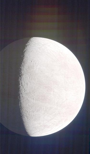
The two large craters on Tethys, near the line where day fades to night, almost resemble two giant eyes observing Saturn. The location of these craters on Tethys' terminator throws their topography into sharp relief. Both are large craters, but the larger and southernmost of the two shows a more complex structure. The angle of the lighting highlights a central peak in this crater. Central peaks are the result of the surface reacting to the violent post-impact excavation of the crater. The northern crater does not show a similar feature. Possibly the impact was too small to form a central peak, or the composition of the material in the immediate vicinity couldn't support the formation of a central peak. In this image Tethys is significantly closer to the camera, while the planet is in the background. Yet the moon is still utterly dwarfed by the giant Saturn. This view looks toward the anti-Saturn side of Tethys. North on Tethys is up and rotated 42 degrees to the right. The image was taken in visible light with the Cassini spacecraft wide-angle camera on April 11, 2015. The view was obtained at a distance of approximately 75,000 miles (120,000 kilometers) from Tethys. Image scale at Tethys is 4 miles (7 kilometers) per pixel. http://photojournal.jpl.nasa.gov/catalog/pia18318
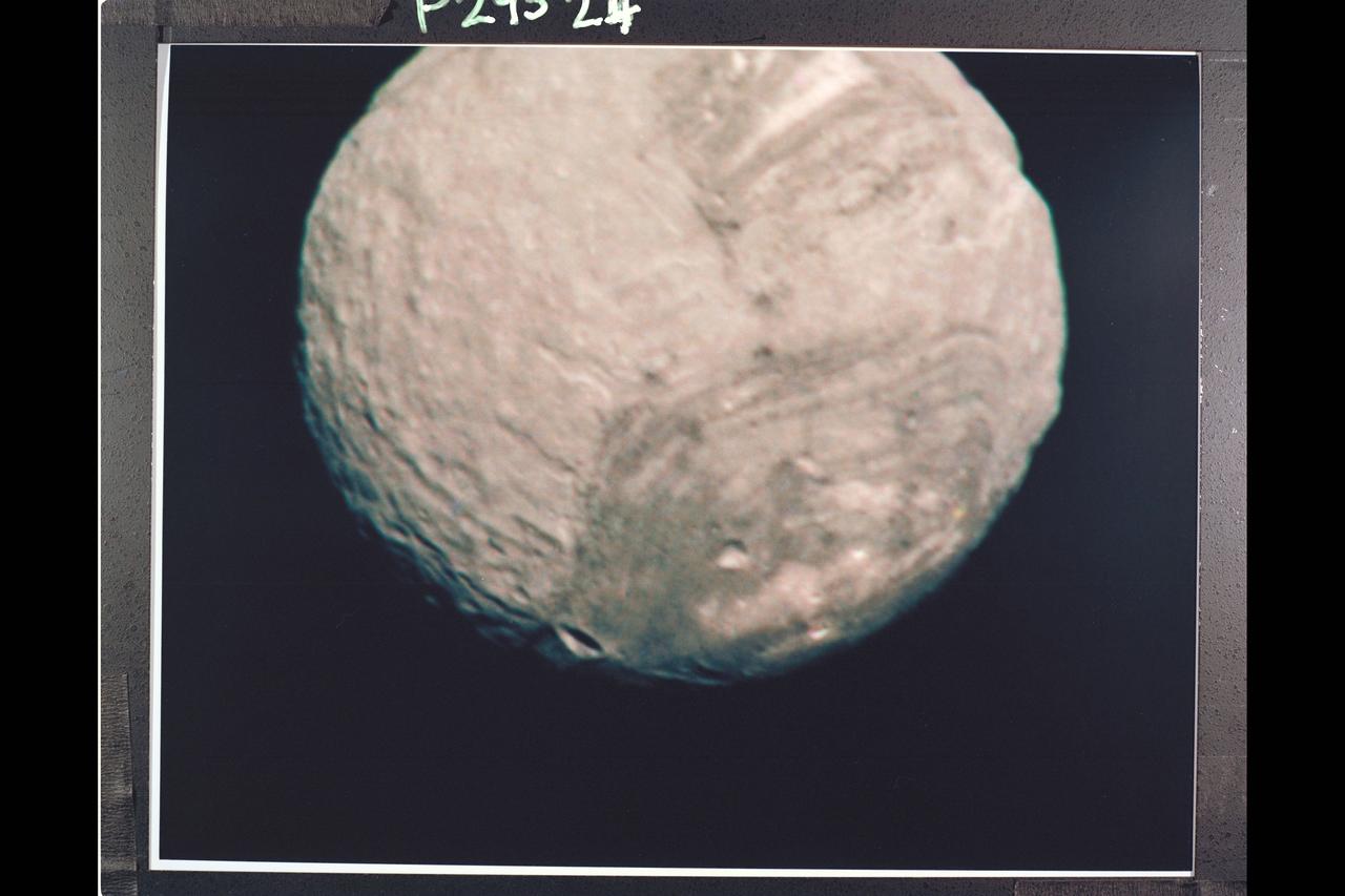
Range : 147,000 km. ( 91,000 mi. ) Resolution : 2.7 km. ( 1.7 mi. ) P-29524C this Voyager 2 color image of the Uranian satellite, Miranda is a composite of three shots taken through green, violet, and ultraviolet filters from the narrow angle camera. It is the best color image of Miranda returned to date. Miranda, just 480 km. (300 mi.) across, is the smallest of Uranus' five major satellites. Miranda's regional geologic provinces show very well in this view of the southern hemisphere. The dark and bright banded region, with its curvilinear traces, covers about half of the image. Higher resolution pictures taken later show many fault lines valleys and ridges parallel to these bands. Near the terminator (at right), another system of ridges and valleys abuts the banded terrain, while many impact craters pockmark the surface in this region. The largest of these are about 30 km. (20 mi.) in diameter. Many more lie in the range of 5 to 10 km. (3 to 6 mi.) in diameter

This map of an area within the Arabia Terra region on Mars shows where hydrologic modeling predicts locations of depressions that would have been lakes (black), overlaid with a map of the preserved valleys (blue lines, with width exaggerated for recognition) that would have been streams. The area today holds numerous features called "fresh shallow valleys." Research findings in 2016 interpret the fresh shallow valleys as evidence for flows of liquid water that occurred several hundred million years -- up to about a billion years -- after the ancient lakes and streams previously documented on Mars. Most of the fresh shallow valleys in this northern portion of Arabia Terra terminate at the margins of model-predicted submerged basins, consistent with an interpretation of flows into lakes and out of lakes. Some valley segments connect to form longer systems, consistent with connections forged by flowing water between interspersed lakes. In the area mapped here, for example, valleys connect basin "A" to basin "B," and basin B to "Heart Lake," each lower in elevation in that chain. http://photojournal.jpl.nasa.gov/catalog/PIA20839
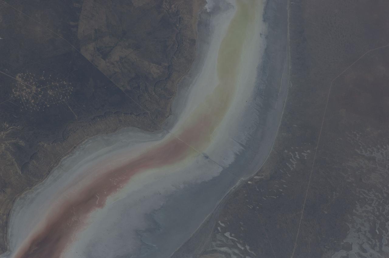
ISS031-E-030896 (11 May 2012) --- The Sor Kaydak near the northeast Caspian Sea in Kazakhstan are featured in this image photographed by an Expedition 31 crew member on the International Space Station. This striking image shows saline water of different colors in the Sor Kaydak, a salt marsh that leads into the northeast bulb of the Caspian Sea. The central 50 kilometers of this 180 kilometer-long depression is shown in this photograph. The Sor Kaydak depression is inundated on occasion by water from the Caspian Sea since it lies at the same elevation?that is, 29 meters below global sea level?though separated from the Sea by a low bar of land that is 1?2 meters high. The different colors of marsh water (brown to pink to light green, northeast to southwest) result from the interplay of water depth and resident organisms such as algae. Algae color varies depending on water temperature and salinity. The irregular gray areas at bottom right are wet zones between low sand dunes. These interdune flats are whitened with salt derived by evaporation of Caspian Sea water (the sea is just outside the image bottom right). The jagged line following the colored water (crossing the center of the image top to bottom) is the limit of the wetting zone (or perimeter), an irregular zone influenced by wind and the depth of water in the marsh. Small cliffs can be seen marking the east margin of the depression that contains Sor Kaydak. Above the cliffs a plateau surface (approximately 200 meters above the salt marsh, approximately 160 meters above global sea level) extends eastward for hundreds of kilometers. Here the plateau is occupied by a dense pattern of well heads which appear as a geometric pattern of tan dots. By contrast, the west margin (right) rises less than 10 meters above the marsh altitude. The straight line visible at center is a pipeline built across the salt marsh which takes oil to a terminal on the Caspian shore 100 kilometers northwest of the area shown here.
art002e010014 (April 6, 2026) – A bright portion of the Moon is visible in this image. If you look closely, you can see linear, pitted features known as “crater chains” radiating from the Orientale basin, an impact crater with a patch of ancient lava at its center, visible in the bottom center of the image. These crater chains formed about 3.8 billion years ago, when rocks spewed from the collision that formed Orientale landed in lines extending away from the crater. These chains are found near other large craters on the Moon, but we don’t get to see them on Earth because our planet’s crust has been turned over so many times through plate tectonics and largely erased by rain, wind, and ice. In the upper left corner of the Moon disk is a line called the terminator, the boundary between lunar day and night. Here, low-angle sunlight skims the surface, casting dramatic shadows that expose the area’s topography — or the shape of its surface. Glushko crater is the bright spot just to the left of the dark mare, or “sea” of ancient lava flows on the near side of the Moon. It’s identifiable by the bright rays that shoot across the mare, some hundreds of miles away. These rays are made of ejected material after the collision that formed Glushko. Glushko and its rays are brighter than the surrounding area because that younger has experienced less weathering from radiation and impacts. Oceanus Procellarum, the largest lava-filled region on the Moon, spans the horizon. The Aristarchus crater, the bright spot in the sea of lava, creeps toward the right edge of the Moon.
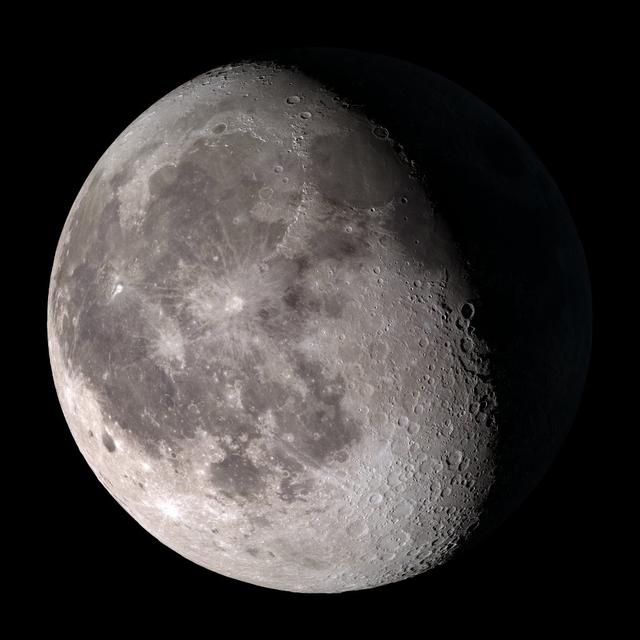
First quarter. Visible high in the southern sky in early evening. NASA's Lunar Reconnaissance Orbiter (LRO) has been in orbit around the Moon since the summer of 2009. Its laser altimeter (LOLA) and camera (LROC) are recording the rugged, airless lunar terrain in exceptional detail, making it possible to visualize the Moon with unprecedented fidelity. This is especially evident in the long shadows cast near the terminator, or day-night line. The pummeled, craggy landscape thrown into high relief at the terminator would be impossible to recreate in the computer without global terrain maps like those from LRO. To download, learn more about this visualization, or to see what the Moon will look like at any hour in 2015, visit <a href="http://svs.gsfc.nasa.gov/goto?4236" rel="nofollow">svs.gsfc.nasa.gov/goto?4236</a> <b><a href="http://www.nasa.gov/audience/formedia/features/MP_Photo_Guidelines.html" rel="nofollow">NASA image use policy.</a></b> <b><a href="http://www.nasa.gov/centers/goddard/home/index.html" rel="nofollow">NASA Goddard Space Flight Center</a></b> enables NASA’s mission through four scientific endeavors: Earth Science, Heliophysics, Solar System Exploration, and Astrophysics. Goddard plays a leading role in NASA’s accomplishments by contributing compelling scientific knowledge to advance the Agency’s mission. <b>Follow us on <a href="http://twitter.com/NASAGoddardPix" rel="nofollow">Twitter</a></b> <b>Like us on <a href="http://www.facebook.com/pages/Greenbelt-MD/NASA-Goddard/395013845897?ref=tsd" rel="nofollow">Facebook</a></b> <b>Find us on <a href="http://instagram.com/nasagoddard?vm=grid" rel="nofollow">Instagram</a></b>
New Moon. By the modern definition, New Moon occurs when the Moon and Sun are at the same geocentric ecliptic longitude. The part of the Moon facing us is completely in shadow then. Pictured here is the traditional New Moon, the earliest visible waxing crescent, which signals the start of a new month in many lunar and lunisolar calendars. NASA's Lunar Reconnaissance Orbiter (LRO) has been in orbit around the Moon since the summer of 2009. Its laser altimeter (LOLA) and camera (LROC) are recording the rugged, airless lunar terrain in exceptional detail, making it possible to visualize the Moon with unprecedented fidelity. This is especially evident in the long shadows cast near the terminator, or day-night line. The pummeled, craggy landscape thrown into high relief at the terminator would be impossible to recreate in the computer without global terrain maps like those from LRO. To download, learn more about this visualization, or to see what the Moon will look like at any hour in 2015, visit <a href="http://svs.gsfc.nasa.gov/goto?4236" rel="nofollow">svs.gsfc.nasa.gov/goto?4236</a> <b><a href="http://www.nasa.gov/audience/formedia/features/MP_Photo_Guidelines.html" rel="nofollow">NASA image use policy.</a></b> <b><a href="http://www.nasa.gov/centers/goddard/home/index.html" rel="nofollow">NASA Goddard Space Flight Center</a></b> enables NASA’s mission through four scientific endeavors: Earth Science, Heliophysics, Solar System Exploration, and Astrophysics. Goddard plays a leading role in NASA’s accomplishments by contributing compelling scientific knowledge to advance the Agency’s mission. <b>Follow us on <a href="http://twitter.com/NASAGoddardPix" rel="nofollow">Twitter</a></b> <b>Like us on <a href="http://www.facebook.com/pages/Greenbelt-MD/NASA-Goddard/395013845897?ref=tsd" rel="nofollow">Facebook</a></b> <b>Find us on <a href="http://instagram.com/nasagoddard?vm=grid" rel="nofollow">Instagram</a></b>

This visualization shows the Moon's phase and libration at hourly intervals throughout 2015, as viewed from the northern hemisphere. Each frame represents one hour. Lunar Reconnaissance Orbiter (LRO) has been in orbit around the Moon since the summer of 2009. Its laser altimeter (LOLA) and camera (LROC) are recording the rugged, airless lunar terrain in exceptional detail, making it possible to visualize the Moon with unprecedented fidelity. This is especially evident in the long shadows cast near the terminator, or day-night line. The pummeled, craggy landscape thrown into high relief at the terminator would be impossible to recreate in the computer without global terrain maps like those from LRO. To download, learn more about this visualization, or to see what the Moon will look like at any hour in 2015, visit <a href="http://svs.gsfc.nasa.gov/goto?4236" rel="nofollow">svs.gsfc.nasa.gov/goto?4236</a> <b><a href="http://www.nasa.gov/audience/formedia/features/MP_Photo_Guidelines.html" rel="nofollow">NASA image use policy.</a></b> <b><a href="http://www.nasa.gov/centers/goddard/home/index.html" rel="nofollow">NASA Goddard Space Flight Center</a></b> enables NASA’s mission through four scientific endeavors: Earth Science, Heliophysics, Solar System Exploration, and Astrophysics. Goddard plays a leading role in NASA’s accomplishments by contributing compelling scientific knowledge to advance the Agency’s mission. <b>Follow us on <a href="http://twitter.com/NASAGoddardPix" rel="nofollow">Twitter</a></b> <b>Like us on <a href="http://www.facebook.com/pages/Greenbelt-MD/NASA-Goddard/395013845897?ref=tsd" rel="nofollow">Facebook</a></b> <b>Find us on <a href="http://instagram.com/nasagoddard?vm=grid" rel="nofollow">Instagram</a></b>
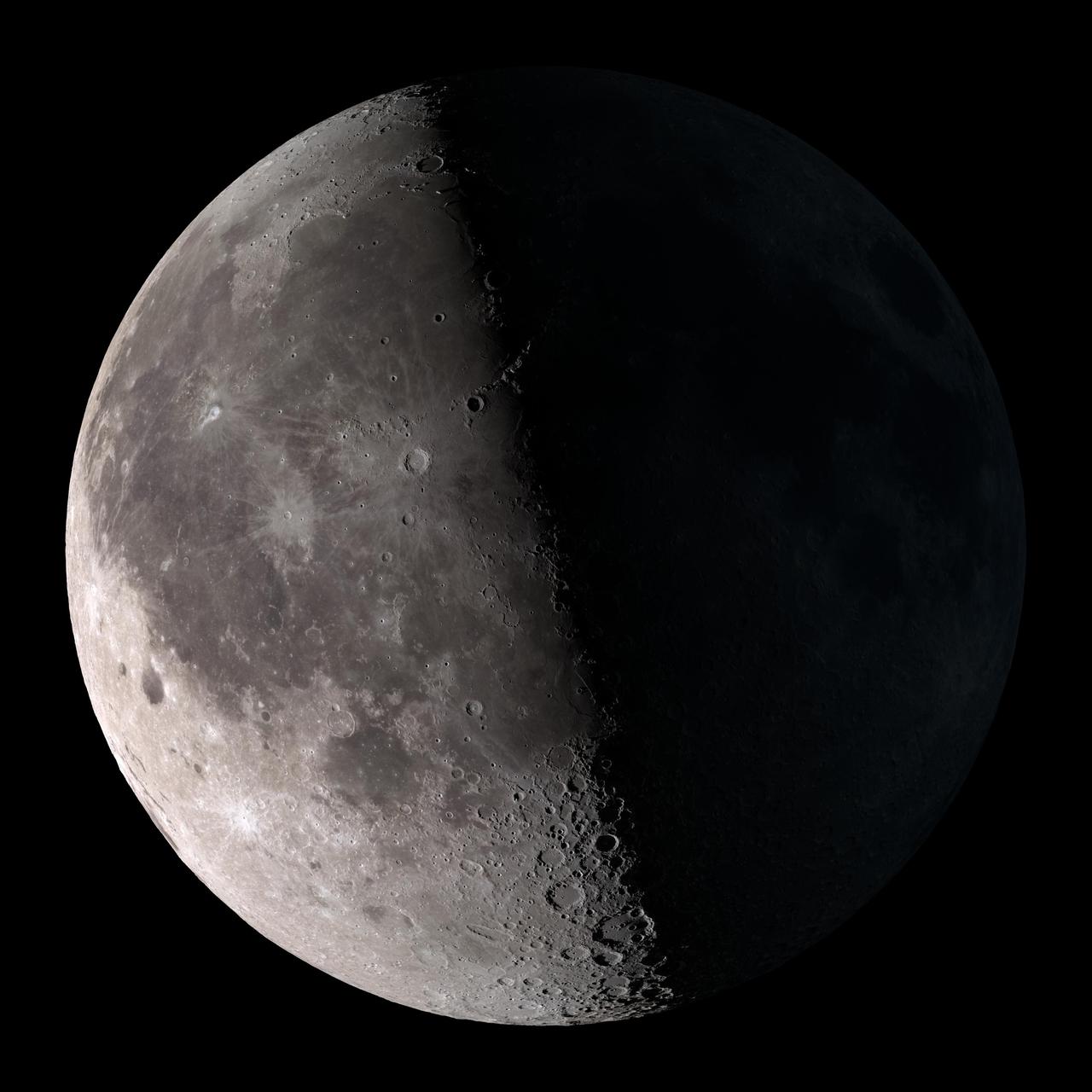
Third quarter. Rises around midnight, visible to the south after sunrise. NASA's Lunar Reconnaissance Orbiter (LRO) has been in orbit around the Moon since the summer of 2009. Its laser altimeter (LOLA) and camera (LROC) are recording the rugged, airless lunar terrain in exceptional detail, making it possible to visualize the Moon with unprecedented fidelity. This is especially evident in the long shadows cast near the terminator, or day-night line. The pummeled, craggy landscape thrown into high relief at the terminator would be impossible to recreate in the computer without global terrain maps like those from LRO. To download, learn more about this visualization, or to see what the Moon will look like at any hour in 2015, visit <a href="http://svs.gsfc.nasa.gov/goto?4236" rel="nofollow">svs.gsfc.nasa.gov/goto?4236</a> <b><a href="http://www.nasa.gov/audience/formedia/features/MP_Photo_Guidelines.html" rel="nofollow">NASA image use policy.</a></b> <b><a href="http://www.nasa.gov/centers/goddard/home/index.html" rel="nofollow">NASA Goddard Space Flight Center</a></b> enables NASA’s mission through four scientific endeavors: Earth Science, Heliophysics, Solar System Exploration, and Astrophysics. Goddard plays a leading role in NASA’s accomplishments by contributing compelling scientific knowledge to advance the Agency’s mission. <b>Follow us on <a href="http://twitter.com/NASAGoddardPix" rel="nofollow">Twitter</a></b> <b>Like us on <a href="http://www.facebook.com/pages/Greenbelt-MD/NASA-Goddard/395013845897?ref=tsd" rel="nofollow">Facebook</a></b> <b>Find us on <a href="http://instagram.com/nasagoddard?vm=grid" rel="nofollow">Instagram</a></b>
Waning gibbous. Rises after sunset, high in the sky after midnight, visible to the southwest after sunrise. NASA's Lunar Reconnaissance Orbiter (LRO) has been in orbit around the Moon since the summer of 2009. Its laser altimeter (LOLA) and camera (LROC) are recording the rugged, airless lunar terrain in exceptional detail, making it possible to visualize the Moon with unprecedented fidelity. This is especially evident in the long shadows cast near the terminator, or day-night line. The pummeled, craggy landscape thrown into high relief at the terminator would be impossible to recreate in the computer without global terrain maps like those from LRO. To download, learn more about this visualization, or to see what the Moon will look like at any hour in 2015, visit <a href="http://svs.gsfc.nasa.gov/goto?4236" rel="nofollow">svs.gsfc.nasa.gov/goto?4236</a> <b><a href="http://www.nasa.gov/audience/formedia/features/MP_Photo_Guidelines.html" rel="nofollow">NASA image use policy.</a></b> <b><a href="http://www.nasa.gov/centers/goddard/home/index.html" rel="nofollow">NASA Goddard Space Flight Center</a></b> enables NASA’s mission through four scientific endeavors: Earth Science, Heliophysics, Solar System Exploration, and Astrophysics. Goddard plays a leading role in NASA’s accomplishments by contributing compelling scientific knowledge to advance the Agency’s mission. <b>Follow us on <a href="http://twitter.com/NASAGoddardPix" rel="nofollow">Twitter</a></b> <b>Like us on <a href="http://www.facebook.com/pages/Greenbelt-MD/NASA-Goddard/395013845897?ref=tsd" rel="nofollow">Facebook</a></b> <b>Find us on <a href="http://instagram.com/nasagoddard?vm=grid" rel="nofollow">Instagram</a></b>
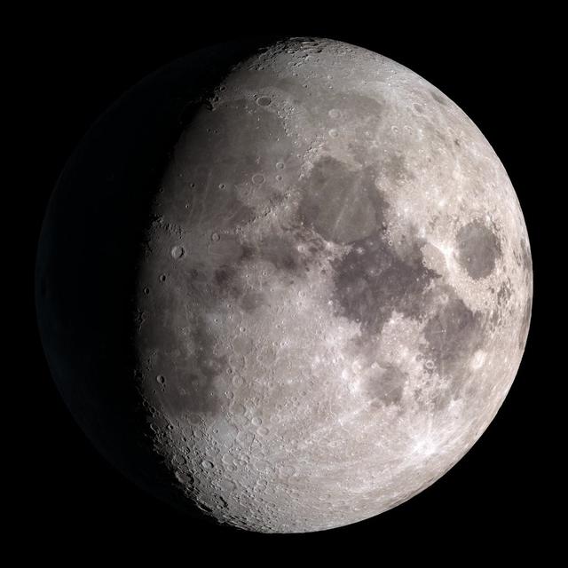
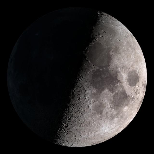
Waxing gibbous. Visible to the southeast in early evening, up for most of the night. NASA's Lunar Reconnaissance Orbiter (LRO) has been in orbit around the Moon since the summer of 2009. Its laser altimeter (LOLA) and camera (LROC) are recording the rugged, airless lunar terrain in exceptional detail, making it possible to visualize the Moon with unprecedented fidelity. This is especially evident in the long shadows cast near the terminator, or day-night line. The pummeled, craggy landscape thrown into high relief at the terminator would be impossible to recreate in the computer without global terrain maps like those from LRO. To download, learn more about this visualization, or to see what the Moon will look like at any hour in 2015, visit <a href="http://svs.gsfc.nasa.gov/goto?4236" rel="nofollow">svs.gsfc.nasa.gov/goto?4236</a> <b><a href="http://www.nasa.gov/audience/formedia/features/MP_Photo_Guidelines.html" rel="nofollow">NASA image use policy.</a></b> <b><a href="http://www.nasa.gov/centers/goddard/home/index.html" rel="nofollow">NASA Goddard Space Flight Center</a></b> enables NASA’s mission through four scientific endeavors: Earth Science, Heliophysics, Solar System Exploration, and Astrophysics. Goddard plays a leading role in NASA’s accomplishments by contributing compelling scientific knowledge to advance the Agency’s mission. <b>Follow us on <a href="http://twitter.com/NASAGoddardPix" rel="nofollow">Twitter</a></b> <b>Like us on <a href="http://www.facebook.com/pages/Greenbelt-MD/NASA-Goddard/395013845897?ref=tsd" rel="nofollow">Facebook</a></b> <b>Find us on <a href="http://instagram.com/nasagoddard?vm=grid" rel="nofollow">Instagram</a></b>
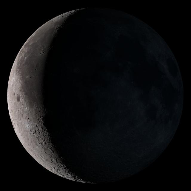
Waning crescent. Low to the east before sunrise. NASA's Lunar Reconnaissance Orbiter (LRO) has been in orbit around the Moon since the summer of 2009. Its laser altimeter (LOLA) and camera (LROC) are recording the rugged, airless lunar terrain in exceptional detail, making it possible to visualize the Moon with unprecedented fidelity. This is especially evident in the long shadows cast near the terminator, or day-night line. The pummeled, craggy landscape thrown into high relief at the terminator would be impossible to recreate in the computer without global terrain maps like those from LRO. To download, learn more about this visualization, or to see what the Moon will look like at any hour in 2015, visit <a href="http://svs.gsfc.nasa.gov/goto?4236" rel="nofollow">svs.gsfc.nasa.gov/goto?4236</a> <b><a href="http://www.nasa.gov/audience/formedia/features/MP_Photo_Guidelines.html" rel="nofollow">NASA image use policy.</a></b> <b><a href="http://www.nasa.gov/centers/goddard/home/index.html" rel="nofollow">NASA Goddard Space Flight Center</a></b> enables NASA’s mission through four scientific endeavors: Earth Science, Heliophysics, Solar System Exploration, and Astrophysics. Goddard plays a leading role in NASA’s accomplishments by contributing compelling scientific knowledge to advance the Agency’s mission. <b>Follow us on <a href="http://twitter.com/NASAGoddardPix" rel="nofollow">Twitter</a></b> <b>Like us on <a href="http://www.facebook.com/pages/Greenbelt-MD/NASA-Goddard/395013845897?ref=tsd" rel="nofollow">Facebook</a></b> <b>Find us on <a href="http://instagram.com/nasagoddard?vm=grid" rel="nofollow">Instagram</a></b>
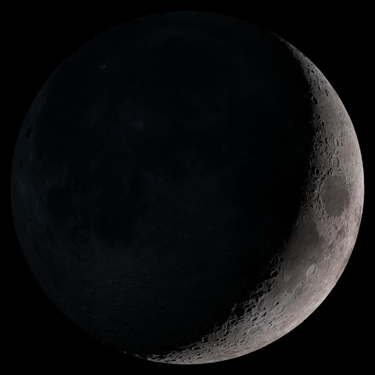
Waxing crescent. Visible toward the southwest in early evening. NASA's Lunar Reconnaissance Orbiter (LRO) has been in orbit around the Moon since the summer of 2009. Its laser altimeter (LOLA) and camera (LROC) are recording the rugged, airless lunar terrain in exceptional detail, making it possible to visualize the Moon with unprecedented fidelity. This is especially evident in the long shadows cast near the terminator, or day-night line. The pummeled, craggy landscape thrown into high relief at the terminator would be impossible to recreate in the computer without global terrain maps like those from LRO. To download, learn more about this visualization, or to see what the Moon will look like at any hour in 2015, visit <a href="http://svs.gsfc.nasa.gov/goto?4236" rel="nofollow">svs.gsfc.nasa.gov/goto?4236</a> <b><a href="http://www.nasa.gov/audience/formedia/features/MP_Photo_Guidelines.html" rel="nofollow">NASA image use policy.</a></b> <b><a href="http://www.nasa.gov/centers/goddard/home/index.html" rel="nofollow">NASA Goddard Space Flight Center</a></b> enables NASA’s mission through four scientific endeavors: Earth Science, Heliophysics, Solar System Exploration, and Astrophysics. Goddard plays a leading role in NASA’s accomplishments by contributing compelling scientific knowledge to advance the Agency’s mission. <b>Follow us on <a href="http://twitter.com/NASAGoddardPix" rel="nofollow">Twitter</a></b> <b>Like us on <a href="http://www.facebook.com/pages/Greenbelt-MD/NASA-Goddard/395013845897?ref=tsd" rel="nofollow">Facebook</a></b> <b>Find us on <a href="http://instagram.com/nasagoddard?vm=grid" rel="nofollow">Instagram</a></b>
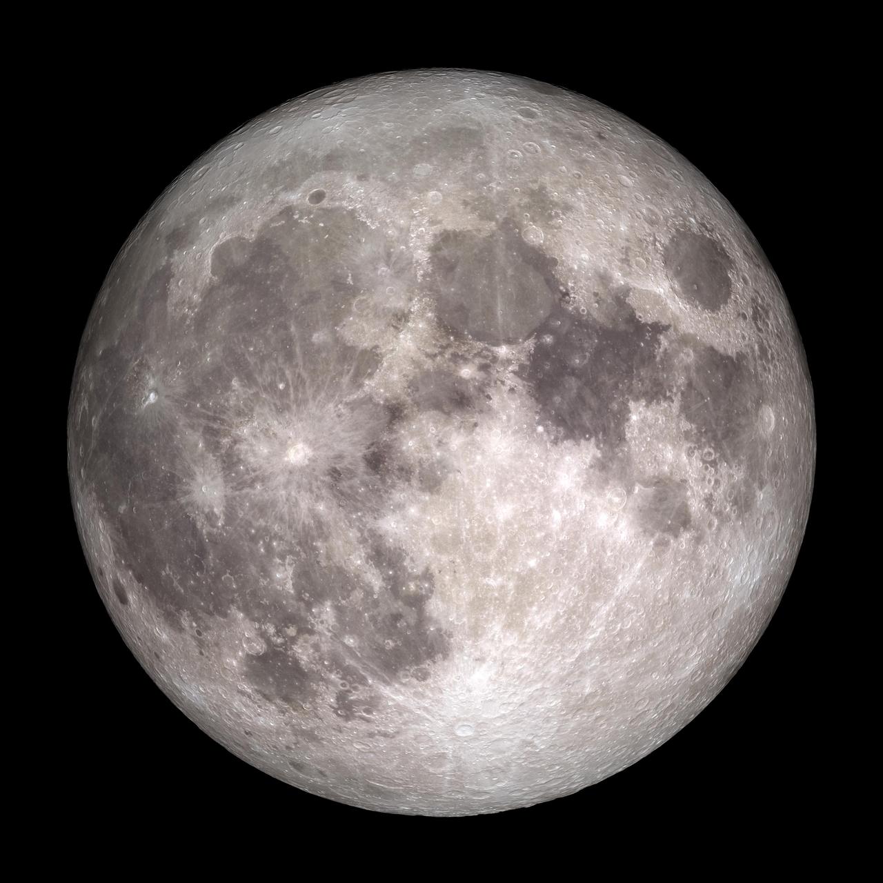
Full Moon. Rises at sunset, high in the sky around midnight. Visible all night. NASA's Lunar Reconnaissance Orbiter (LRO) has been in orbit around the Moon since the summer of 2009. Its laser altimeter (LOLA) and camera (LROC) are recording the rugged, airless lunar terrain in exceptional detail, making it possible to visualize the Moon with unprecedented fidelity. This is especially evident in the long shadows cast near the terminator, or day-night line. The pummeled, craggy landscape thrown into high relief at the terminator would be impossible to recreate in the computer without global terrain maps like those from LRO. To download, learn more about this visualization, or to see what the Moon will look like at any hour in 2015, visit <a href="http://svs.gsfc.nasa.gov/goto?4236" rel="nofollow">svs.gsfc.nasa.gov/goto?4236</a> <b><a href="http://www.nasa.gov/audience/formedia/features/MP_Photo_Guidelines.html" rel="nofollow">NASA image use policy.</a></b> <b><a href="http://www.nasa.gov/centers/goddard/home/index.html" rel="nofollow">NASA Goddard Space Flight Center</a></b> enables NASA’s mission through four scientific endeavors: Earth Science, Heliophysics, Solar System Exploration, and Astrophysics. Goddard plays a leading role in NASA’s accomplishments by contributing compelling scientific knowledge to advance the Agency’s mission. <b>Follow us on <a href="http://twitter.com/NASAGoddardPix" rel="nofollow">Twitter</a></b> <b>Like us on <a href="http://www.facebook.com/pages/Greenbelt-MD/NASA-Goddard/395013845897?ref=tsd" rel="nofollow">Facebook</a></b> <b>Find us on <a href="http://instagram.com/nasagoddard?vm=grid" rel="nofollow">Instagram</a></b>

Images acquired December 21, 2010 - September 20, 2011. To view a HD animation of this go to: <a href="http://www.flickr.com/photos/gsfc/6175313242/in/photostream/">www.flickr.com/photos/gsfc/6175313242/in/photostream/</a> To download the high res and learn more go to: <a href="http://earthobservatory.nasa.gov/IOTD/view.php?id=52248" rel="nofollow">earthobservatory.nasa.gov/IOTD/view.php?id=52248</a> One of the most frequently misunderstood concepts in science is the reason for Earth’s seasons. As we experience the September equinox today—anyone try to balance an egg yet?—we thought we’d offer a space-based view of what’s going on. Around 6 a.m. local time each day, the Sun, Earth, and any geosynchronous satellite form a right angle, affording a nadir (straight down) view of the terminator, where the shadows of nightfall meet the sunlight of dusk and dawn. The shape of this line between night and day varies with the seasons, which means different lengths of days and differing amounts of warming sunshine. (The line is actually a curve because the Earth is round, but satellite images only show it in two-dimensions.) The Spinning Enhanced Visible and Infrared Imager (SEVIRI) on EUMETSAT's Meteosat-9 captured these four views of the day-night terminator on December 21, 2010, and March 20, June 21, and September 20, 2011. Each image was taken at 6:12 a.m. local time. On March 20 and September 20, the terminator is a straight north-south line, and the Sun is said to sit directly above the equator. On December 21, the Sun resides directly over the Tropic of Capricorn when viewed from the ground, and sunlight spreads over more of the Southern Hemisphere. On June 21, the Sun sits above the Tropic of Cancer, spreading more sunlight in the north and turning the tables on the south. The bulge of our spherical Earth blocks sunlight from the far hemisphere at the solstices; that same curvature allows the Sun’s rays to spread over more area near the top and bottom of the globe. Of course, it is not the Sun that is moving north or south through the seasons, but a change in the orientation and angles between the Earth and its nearest star. The axis of the Earth is tilted 23.5 degrees relative to the Sun and the ecliptic plane. The axis is tilted away from the Sun at the December solstice and toward the Sun at the June solstice, spreading more and less light on each hemisphere. At the equinoxes, the tilt is at a right angle to the Sun and the light is spread evenly. The equinox and changing of the seasons occurs on September 23, 2011 at 9:05 a.m. Universal Time. (Our September image above is a few days early.) Equinox means "equal night" in Latin, capturing the idea that daytime and nighttime are equal lengths everywhere on the planet. That is true of the Sun's presence above the horizon, though it does not account for twilight, when the Sun's rays extend from beyond the horizon to illuminate our gas-filled atmosphere. NASA images and animation by Robert Simmon, using data ©2010 EUMETSAT. Caption by Mike Carlowicz. Instrument: Meteosat Credit: <b><a href="http://www.earthobservatory.nasa.gov/" rel="nofollow"> NASA Earth Observatory</a></b> <b><a href="http://www.nasa.gov/audience/formedia/features/MP_Photo_Guidelines.html" rel="nofollow">NASA image use policy.</a></b> <b><a href="http://www.nasa.gov/centers/goddard/home/index.html" rel="nofollow">NASA Goddard Space Flight Center</a></b> enables NASA’s mission through four scientific endeavors: Earth Science, Heliophysics, Solar System Exploration, and Astrophysics. Goddard plays a leading role in NASA’s accomplishments by contributing compelling scientific knowledge to advance the Agency’s mission. <b>Follow us on <a href="http://twitter.com/NASAGoddardPix" rel="nofollow">Twitter</a></b> <b>Like us on <a href="http://www.facebook.com/pages/Greenbelt-MD/NASA-Goddard/395013845897?ref=tsd" rel="nofollow">Facebook</a></b> <b>Find us on <a href="http://instagrid.me/nasagoddard/?vm=grid" rel="nofollow">Instagram</a></b>
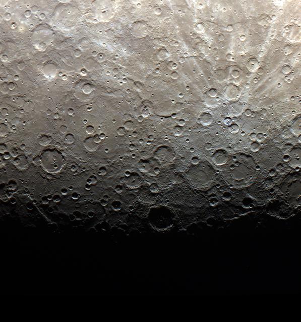
NASA release date June 21, 2011 The terminator of Mercury, shown here in color, is the line between light and dark, or day and night. On Mercury, three days are equivalent to two years, or in other words, the planet spins around its axis three times for every two orbits around the Sun. The first Mercury year of the MESSENGER mission ended on Monday, June 13, 2011. This image was acquired as part of MDIS's color base map. The color base map is composed of WAC images taken through eight different narrow-band color filters and will cover more than 90% of Mercury's surface with an average resolution of 1 kilometer/pixel (0.6 miles/pixel). The highest-quality color images are obtained for Mercury's surface when both the spacecraft and the Sun are overhead, so these images typically are taken with viewing conditions of low incidence and emission angles. The MESSENGER spacecraft is the first ever to orbit the planet Mercury, and the spacecraft's seven scientific instruments and radio science investigation are unraveling the history and evolution of the Solar System's innermost planet. Visit the Why Mercury? section of this website to learn more about the key science questions that the MESSENGER mission is addressing. During the one-year primary mission, MDIS is scheduled to acquire more than 75,000 images in support of MESSENGER's science goals. Credit: NASA/Johns Hopkins University Applied Physics Laboratory/Carnegie Institution of Washington <b><a href="http://www.nasa.gov/centers/goddard/home/index.html" rel="nofollow">NASA Goddard Space Flight Center</a></b> enables NASA’s mission through four scientific endeavors: Earth Science, Heliophysics, Solar System Exploration, and Astrophysics. Goddard plays a leading role in NASA’s accomplishments by contributing compelling scientific knowledge to advance the Agency’s mission. <b>Follow us on <a href="http://twitter.com/NASA_GoddardPix" rel="nofollow">Twitter</a></b> <b>Like us on <a href="http://www.facebook.com/pages/Greenbelt-MD/NASA-Goddard/395013845897?ref=tsd" rel="nofollow">Facebook</a></b> <b>Find us on <a href="http://web.stagram.com/n/nasagoddard/?vm=grid" rel="nofollow">Instagram</a></b>
ISS013-E-06947 (12 April 2006) --- Viedma Glacier, Argentina is featured in this image photographed by an Expedition 13 crewmember on the International Space Station. The ice fields of Patagonia, located at the southern end of South America, are the largest masses of ice in the temperate Southern Hemisphere (approximately 55,000 square kilometers in area). The ice fields contain numerous valley glaciers that terminate in melt-water-fed lakes. These are known as "calving" glaciers, as they lose mass by collapse of large ice chunks from the terminus--or end--of the glacier. These newly separated chunks of ice are then free to float away, much like ice cubes in a punch bowl. The Patagonian glaciers are closely monitored using remotely sensed data as they respond to regional climate change. Visual comparison of time series of images is typically performed to quantify change in ice extent and position. The terminus of the Viedma Glacier, approximately two kilometers across where it enters Lake Viedma, is shown in this image. Moraines are accumulations of soil and rock debris that form along the sides and front of a glacier as it flows across the landscape (much like a bulldozer). Independent valley glaciers can merge together as they flow down-slope, and the moraines become entrained in the center of the new ice mass. These medial moraines are visible as dark parallel lines within the white central mass of the glacier (image center and left). Crevasses - oriented roughly perpendicular to the medial moraines - are also visible in the grey-brown ice along the sides of the glacier. According to scientists, the canyon-like crevasses form as a result of stress between the slower moving ice along the valley sides and the more rapidly moving ice in the center of the glacier. Calving of ice from the southwestern fork of the glacier terminus is visible at image lower left.
NASA's Voyager 2 high resolution color image, taken 2 hours before closest approach, provides obvious evidence of vertical relief in Neptune's bright cloud streaks. These clouds were observed at a latitude of 29 degrees north near Neptune's east terminator. The linear cloud forms are stretched approximately along lines of constant latitude and the sun is toward the lower left. The bright sides of the clouds which face the sun are brighter than the surrounding cloud deck because they are more directly exposed to the sun. Shadows can be seen on the side opposite the sun. These shadows are less distinct at short wavelengths (violet filter) and more distinct at long wavelengths (orange filter). This can be understood if the underlying cloud deck on which the shadow is cast is at a relatively great depth, in which case scattering by molecules in the overlying atmosphere will diffuse light into the shadow. Because molecules scatter blue light much more efficiently than red light, the shadows will be darkest at the longest (reddest) wavelengths, and will appear blue under white light illumination. The resolution of this image is 11 kilometers (6.8 miles per pixel) and the range is only 157,000 kilometers (98,000 miles). The width of the cloud streaks range from 50 to 200 kilometers (31 to 124 miles), and their shadow widths range from 30 to 50 kilometers (18 to 31 miles). Cloud heights appear to be of the order of 50 kilometers (31 miles). This corresponds to 2 scale heights. http://photojournal.jpl.nasa.gov/catalog/PIA00058

This sequence of color-enhanced images shows how quickly the viewing geometry changes for NASA's Juno spacecraft as it swoops by Jupiter. The images were obtained by JunoCam. Once every 53 days, Juno swings close to Jupiter, speeding over its clouds. In just two hours, the spacecraft travels from a perch over Jupiter's north pole through its closest approach (perijove), then passes over the south pole on its way back out. This sequence shows 11 color-enhanced images from Perijove 8 (Sept. 1, 2017) with the south pole on the left (11th image in the sequence) and the north pole on the right (first image in the sequence). The first image on the right shows a half-lit globe of Jupiter, with the north pole approximately at the upper center of the image close to the terminator -- the dividing line between night and day. As the spacecraft gets closer to Jupiter, the horizon moves in and the range of visible latitudes shrinks. The second and third images in this sequence show the north polar region rotating away from the spacecraft's field of view while the first of Jupiter's lighter-colored bands comes into view. The fourth through the eighth images display a blue-colored vortex in the mid-southern latitudes near Points of Interest "Collision of Colours," "Sharp Edge," "Caltech, by Halka," and "Structure01." The Points of Interest are locations in Jupiter's atmosphere that were identified and named by members of the general public. Additionally, a darker, dynamic band can be seen just south of the vortex. In the ninth and tenth images, the south polar region rotates into view. The final image on the left displays Jupiter's south pole in the center. From the start of this sequence of images to the end, roughly 1 hour and 35 minutes elapsed. https://photojournal.jpl.nasa.gov/catalog/PIA21967 . - Enhanced image by Kevin M. Gill (CC-BY) based on images provided courtesy of NASA/JPL-Caltech/SwRI/MSSS
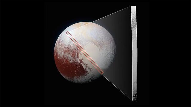
This frame from a movie, which extends across the hemisphere that faced New Horizons spacecraft as it flew past Pluto on July 14, 2015, includes all of the highest-resolution images taken by the NASA probe. With a resolution of about 260 feet (80 meters) per pixel, the movie affords New Horizons scientists and the public the best opportunity to examine the fine details of the various types of terrain the mosaic covers, and determine the processes that formed and shaped them. The view extends from the "limb" of Pluto at the top of the strip, almost to the "terminator" (or day/night line) in the southeast of the encounter hemisphere, seen at the bottom of the strip. The width of the strip ranges from more than 55 miles (90 kilometers) at its northern end to about 45 miles (75 kilometers) at its southern end. The perspective changes greatly along the strip: at its northern end, the view looks out horizontally across the surface, while at its southern end, the view looks straight down onto the surface. This movie pans down the mosaic from top to bottom, offering new views of many of Pluto's distinct landscapes along the way. Starting with hummocky, cratered uplands at top, the view crosses over parallel ridges of the "washboard" terrain; chaotic and angular mountain ranges; the craterless, cellular plains; coarsely "pitted" areas of sublimating nitrogen ice; zones of thin nitrogen ice draped over the topography below; and rugged, dark, mountainous highlands scarred by deep pits. The frames in the movie were obtained by New Horizons' Long Range Reconnaissance Imager (LORRI) approximately 9,850 miles (15,850 kilometers) from Pluto, about 23 minutes before New Horizons' closest approach. LORRI is only capable of obtaining black-and-white images; all color images are made by the Ralph instrument, which has somewhat lower resolution than LORRI. Movies are available at http://photojournal.jpl.nasa.gov/catalog/PIA14457
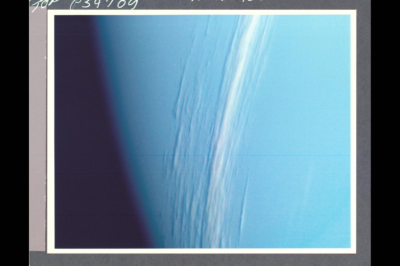
P-34709 Range: 157,000 kilometers (98,000 miles) This Voyager 2 high resolution color image, taken 2 hours before closest approach, provides obvious evidence of vertical relief in Neptune's bright cloud streaks. These clouds were observed at a latitude of 29° N near Neptune's east terminator. The linear cloud forms are stretched approximately along lines of constant latitude and the sun is toward the lower left. The bright sides of the clouds that face the sun are brighter than the surrounding cloud deck because they are more directly exposed to the sun. Shadows can be seen on the side directly opposite the sun. These shadows are less distinct at short wavelengths (violet filter) and more distinct at long wavelengths (orange filter). This can be understood if the underlying cloud deck on which the shadow is cast is at a relatively great depth, in which case scattering by molecules in the overlying atmopsphere will diffuse light into the shadow. Because molecules scatter blue light much more efficiently than red light, the shadows will be darkest at the longest (reddest) wavelengths, and will appear blue under white illumination. The resolution of this image is 11 kilometers (6.8 miles per pixel). The width of the cloud streaks range from 50 to 200 kilometers (31 to 124 miles), and their shadow widths range from 30 to 50 kilometers (18 to 31 miles). Cloud heights appear to be of the order of 50 kilometers (31 miles). This corresponds to 2 scale heights.
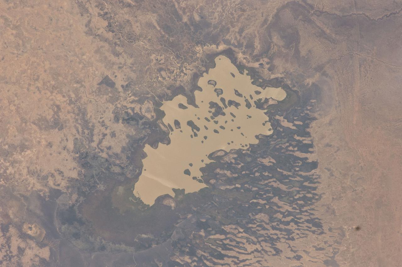
ISS030-E-059398 (19 Jan. 2012) --- Lake Fitri, Chad is featured in this image photographed by an Expedition 30 crew member on the International Space Station. Lake Fitri is an endorheic, or terminal lake in a desert basin in the southern Sahara Desert. Muddy yellow-brown water marks the center of the depression (center), with a ring of dark brown muds and burnt vegetation on the exposed lake floor to the north. The lake shoreline supports a thin line of reed and floating grass vegetation which appears as dark green in the image. Deserts have so little rainfall that many rivers cannot reach the sea, but end at local low points where they form lakes. Here the usually dry Wadi Batha empties into Lake Fitri. Over time, water flow in Wadi Batha has created a large delta, which occupies the entire top left third of the image—a sense of scale is given by the 23–kilometer length of the lake. The lake has been designated under the Ramsar Convention as a wetland of international importance. Other features visible in the image reveal evidence of significant climate change. The dry part of the present lake shows that the lake has been larger in the last several decades. But, as NASA scientists point out, the lake was once many times larger than its present surface area, as shown by numerous sweeping curves of ancient beaches which are now situated many kilometers from the present shoreline, at higher altitudes (upper right). Inland lakes are highly sensitive to the exact equilibrium between the amount of inflow from contributing rivers like Wadi Batha and evaporation. Each beach ridge therefore shows a different lake level and thus a different balance in the lake-river-climate system. A smaller river enters from the south (top right) and cuts through the beach reaches on its way to the lake. The irregular, elongated, tan patches to the west of the lake are linear dunes aligned parallel to the dominant winds which blow from the northeast. The dunes have all formed on the downwind side (southwest) side of the lake since the lake bed and delta provide the sands which have built the dunes. The dunes indicate that during past climatic phases the lake has been almost or completely dry on repeated occasions—often enough for these great dunes, many kilometers long and several meters high, to form even in the lowest parts of the lake. The islands visible in the center of the lake are likewise remnants of dunes. These dunes are smaller than those on the lake margin, presumably because waves from the lake have eroded them. Villages occupy the points of some major dunes, and some islands, where fishermen can gain easy access to the lake.