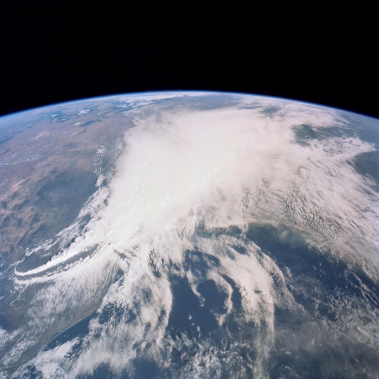
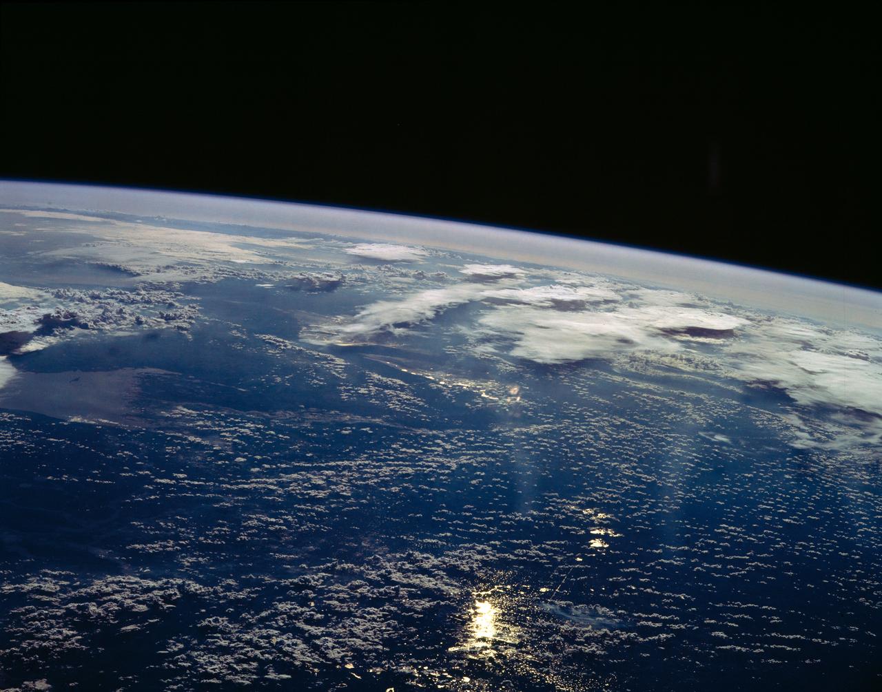
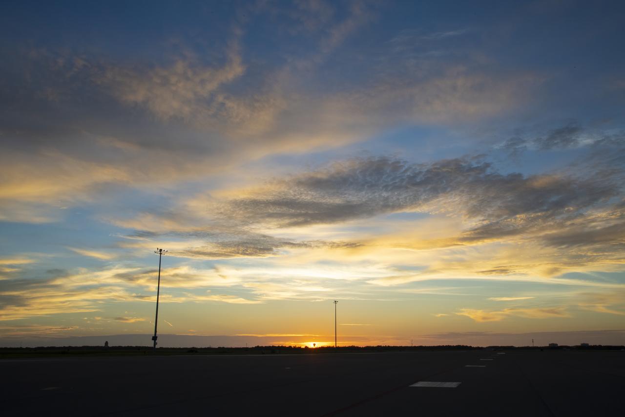
This thunderstorm along the Texas Gulf Coast (29.0N, 95.0W), USA is seen as the trailing edge of a large cloud mass formed along the leading edge of a spring frontal system stretching northwest to southeast across the Texas Gulf Coast. This system brought extensive severe weather and flooding to parts of Texas and surrounding states. Muddy water discharging from coastal streams can be seen in the shallow Gulf of Mexico as far south as Lavaca Bay.
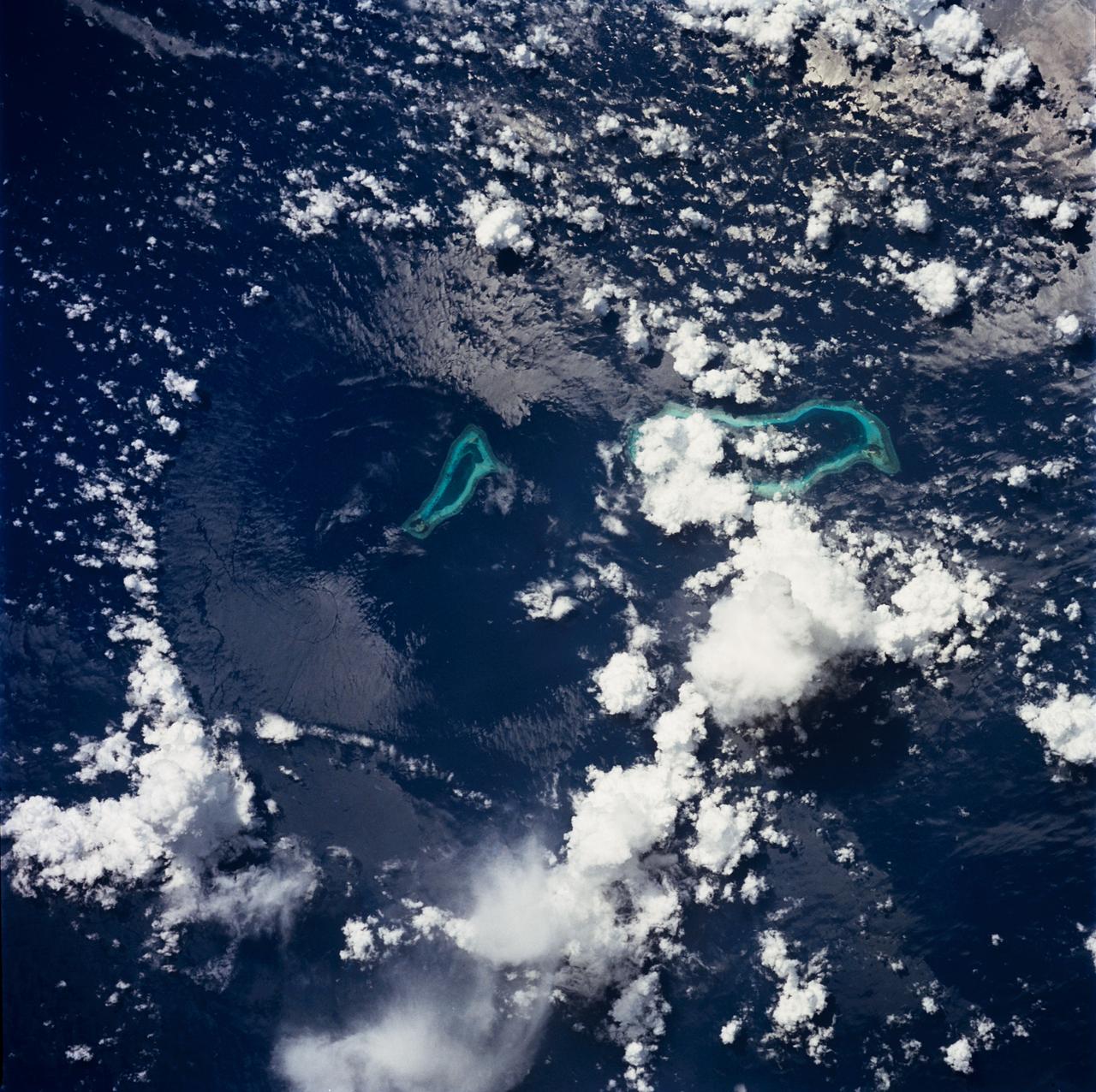
STS049-71-042 (8 May 1992) --- This photograph, taken from the Earth-orbiting Space Shuttle Endeavour, shows a collapsed thunderstorm in the southwestern Pacific Ocean. The clouds were pushed from this circular area of the ocean's surface by relatively cool air that spread downward and outward from a dying thunderstorm. Around the edges of the downdrafted air, new, though smaller, storms are developing. The photo was taken on May 8, 1992, between Borneo and the Philippine island of Mindoro. Two coral atolls can be seen near the center of the photograph. The crew members used a handheld Hasselblad camera, 250-mm lens, color film to expose the image.
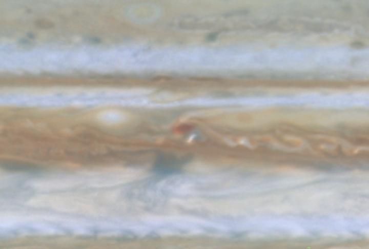
Water Cloud Thunderstorm Northwest of Great Red Spot
STS064-83-099 (9-20 Sept. 1994) --- Multiple thunderstorm cells leading to Earth's atmosphere were photographed on 70mm by the astronauts, orbiting aboard the space shuttle Discovery 130 nautical miles away. These thunderstorms are located about 16 degrees southeast of Hawaii in the Pacific Ocean. Every stage of a developing thunderstorm is documented in this photo; from the building cauliflower tops to the mature anvil phase. The anvil or the tops of the clouds being blown off are at about 50,000 feet. The light line in the blue atmosphere is either clouds in the distance or an atmospheric layer which is defined but different particle sizes. Photo credit: NASA or National Aeronautics and Space Administration
STS054-151-150 (13-19 Jan 1993) --- View west into sun glint off the Rio Salado, Saladillo, and Parana Rivers in Argentina. The Space Shuttle nadir is about 28 degrees north latitude and 57 degrees west longitude. The Andes Mountains are barely visible on Earth's limb. Thunderstorms along the eastern edge of the Andes are typical of this time of year (Southern Hemisphere summer), with anvils moving to the east from the core of the storm.

STS035-607-024 (2-10 Dec. 1990) --- This is one of 25 visuals used by the STS-35 crew at its Dec. 20, 1990 post-flight press conference. Space Shuttle Columbia's flight of almost nine days duration (launched December 2 from Kennedy Space Center (KSC) and landed December 10 at Edwards Air Force Base) carried the Astro-1 payload and was dedicated to astrophysics. The mission involved a seven-man crew. Crew members were astronauts Vance D. Brand, Guy S. Gardner, Jeffrey A. Hoffman, Robert A.R. Parker and John M. (Mike) Lounge; and payload specialists Samuel T. Durrance and Ronald A. Parise. Thunderstorm systems over the Pacific Ocean, with heavy sunglint, as photographed with a handheld Rolleiflex camera aimed through Columbia's aft flight deck windows.
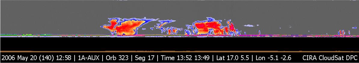
NASA CloudSat image of a horizontal cross-section of tropical clouds and thunderstorms over east Africa.
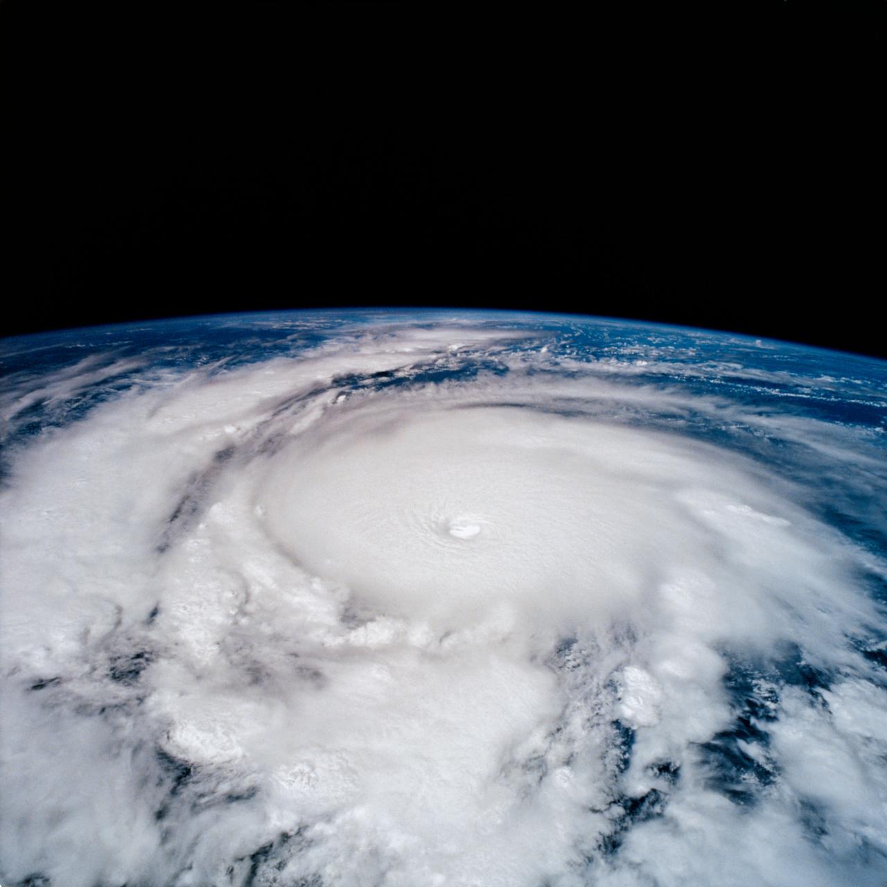
STS-65 Earth observation taken aboard Columbia, Orbiter Vehicle (OV) 102, shows Hurricane Emilia in the Eastern Pacific Ocean. Hurricane Emilia's wind speeds exceeded 150 knots. This high oblique view of the storm shows numerous spiral bands of thunderstorms, overshooting thunderstorm tops at the tropopause, and a well developed eye at the center of the picture. Shuttle photography provides high resolution details of these powerful and destructive systems that are not fully possible from lower-resolution, unmanned satellites.
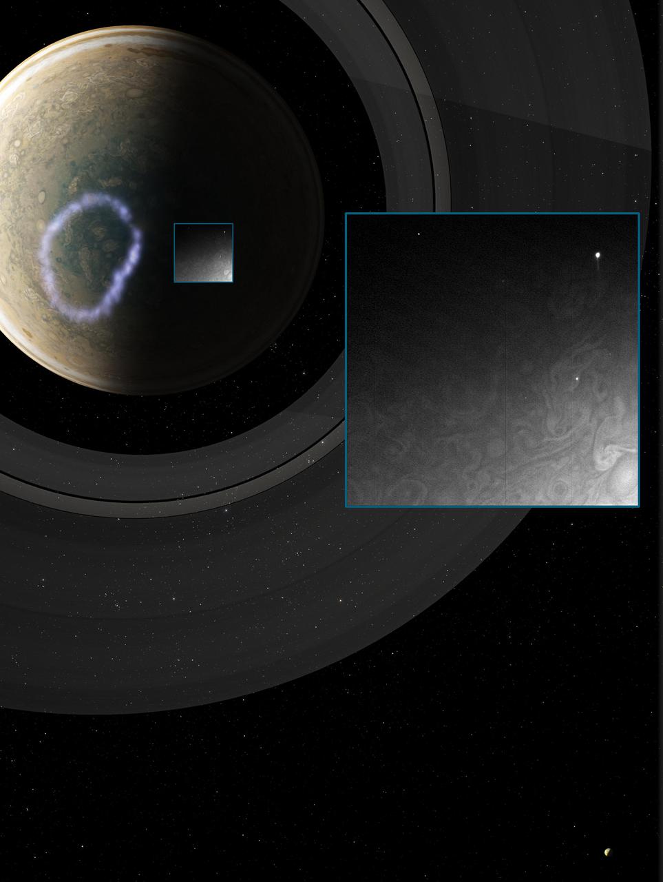
Taken by NASA Cassini spacecraft, a small white spot, probably a thunderstorm, lies to the south of a larger, brown spot on Jupiter.

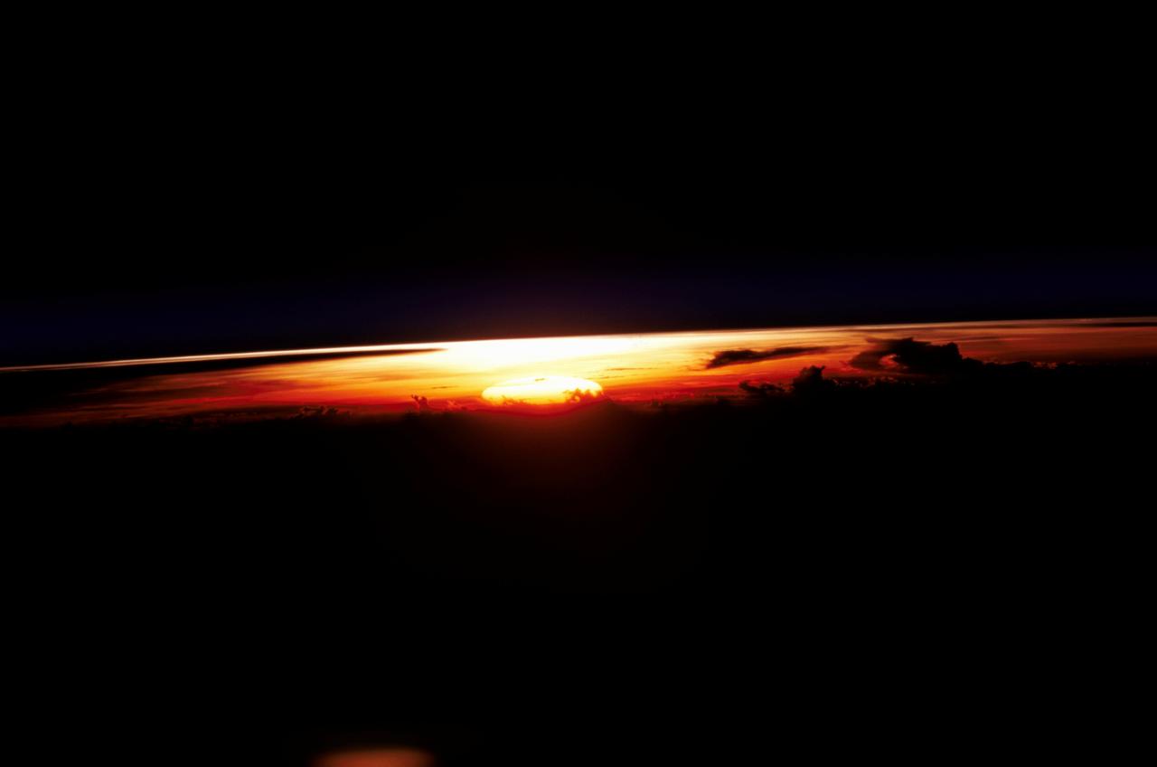
STS047-54-018 (12-20 Sept. 1992) --- The colors in this photograph provide insight into the relative density of the atmosphere. The crew members had many opportunities to witness sunrises and sunsets, considering they orbit the Earth every 90 minutes, but few, they said, compared to this scene. It captures the silhouette of several mature thunderstorms with their cirrus anvil tops spreading out against the tropopause (the top of the lowest layer of Earth's atmosphere) at sunset. The lowest layer (troposphere) is the densest and refracts light at the red end of the visible spectrum (7,400 Angstroms), while the blues (4,000 Angstroms) are separated in the least dense portion of the atmosphere (middle and upper atmosphere, or stratosphere and mesosphere). Several layers of blue can be seen. NASA scientists studying the photos believe this stratification to be caused by the scattering of light by particulate trapped in the stratosphere and mesosphere particulate that generally originate from volcanic eruptions, such as those of Mt. Pinatubo in the Philippines and, most recently, Mt. Spurr in Alaska.

This false-color image, made from infrared data obtained by NASA Cassini spacecraft, shows dark and bright clouds on Saturn associated with thunderstorm activity.
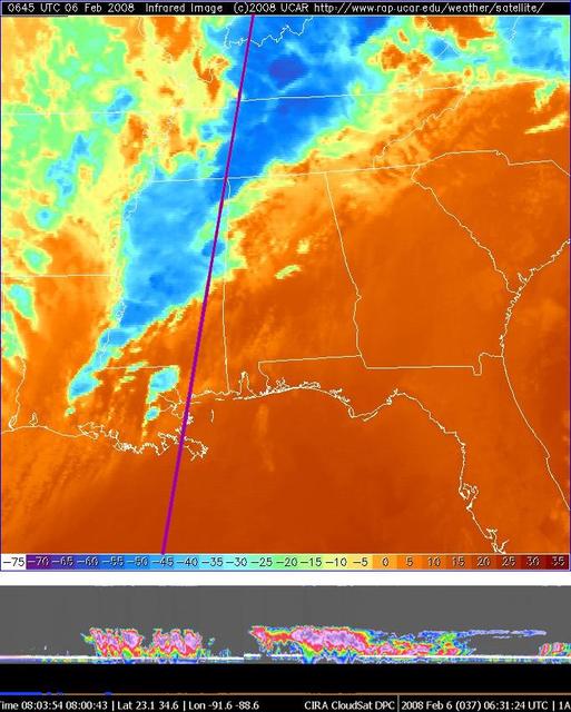
NASA CloudSat made a nighttime overpass approximately 0630 UTC of the thunderstorms responsible for the tornadic outbreak over Kentucky, Tennessee, and Mississippi on Tuesday, February 5, 2008.

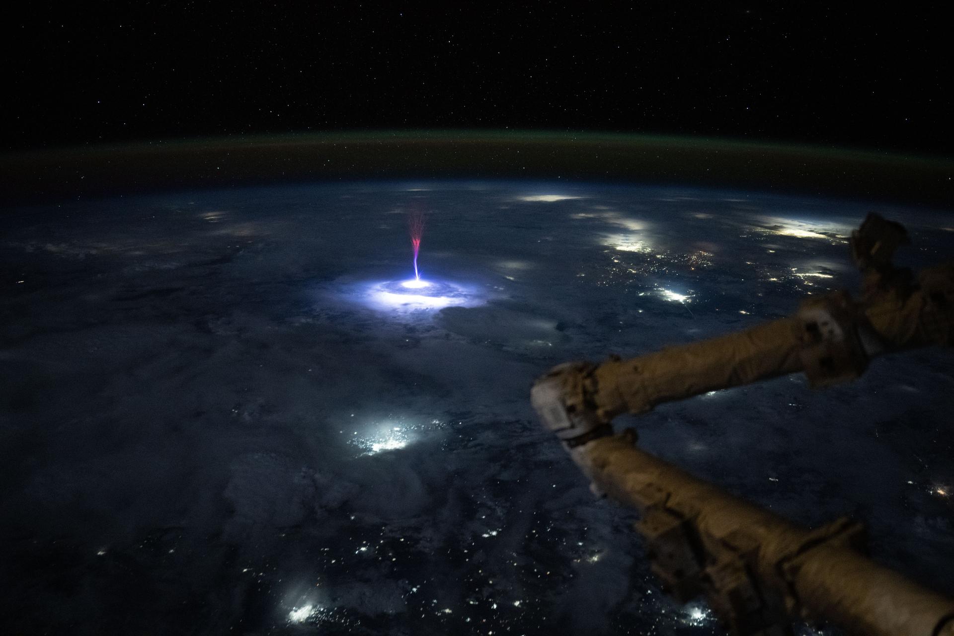
iss071e170351 (6/3/2024) --- NASA astronaut Matthew Dominick captured red sprites from space station. The bright red flashes in the center of this image are a little-understood phenomenon associated with powerful lightning events and appear high above the clouds in Earth’s upper atmosphere. Red sprites are one type of Transient Luminous Events, colorful bursts of energy that appear above storms due to lightning activity occurring in and below storms on Earth. Understanding processes occurring in Earth’s atmosphere can help improve climate modeling and monitoring.

This image is a still frame, created from images taken by NASA Cassini spacecraft, shows a turbulent region west of Jupiter Great Red Spot. The small, bright white spots are believed to be thunderstorms.
NASA Aqua satellite captured an infrared image of the storms on April 16, 2011 showing very cold, high cloud tops of the strong thunderstorms that spawned tornadoes in North Carolina and Virginia.
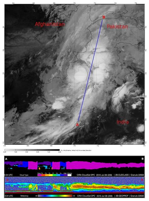
In late July 2010, flooding caused by heavy monsoon rains began in several regions of Pakistan. This image from NASA Aqua spacecraft reveals the bright white cloud tops from the cluster of thunderstorms.
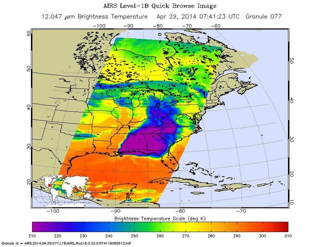
NASA Aqua spacecraft passed over central and southern United States on April 27-29, 2014 capturing this false-color infrared image of the slow-moving low-pressure system that spawned the strong supercell thunderstorms.

STS083-712-068 (4-8 April 1997)--- This is a thunderstorm cell that towers above the surrounding cloud deck and is illuminated by the last rays of the setting sun.
Marshall researchers conduct extensive analysis of weather patterns by using remote sensing on lightning and thunderstorms from outer space for the Mission to Planet Earth program.
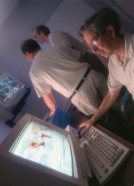
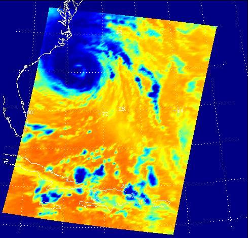
A NASA team studying the causes of electrical storms and their effects on our home planet achieved a milestone on August 21, 2002, completing the study's longest-duration research flight and monitoring four thunderstorms in succession. Based at the Naval Air Station Key West, Florida, researchers with the Altus Cumulus Electrification Study (ACES) used the Altus II remotely-piloted aircraft to study thunderstorms in the Atlantic Ocean off Key West and the west of the Everglades. Using special equipment aboard the Altus II, scientists in ACES will gather electric, magnetic, and optical measurements of the thunderstorms, gauging elements such as lightning activity and the electrical environment in and around the storms. With dual goals of gathering weather data safely and testing the adaptability of the uninhabited aircraft, the ACES study is a collaboration among the Marshall Space Flight Center, the University of Alabama in Huntsville, NASA's Goddard Space Flight Center in Greenbelt, Maryland, Pernsylvania State University in University Park, and General Atomics Aeronautical Systems, Inc.
This image is the first observation of "shallow lightning" flashes — signatures of high-altitude Jovian thunderstorms that may fundamentally influence the composition of Jupiter's atmosphere. The image of was acquired by NASA's Juno mission using the spacecraft's sensitive Stellar Reference Unit navigation camera during Juno's 10th science flyby on Feb. 7, 2018. The solar-powered Jupiter explorer launched on Aug. 5, 2011 and went into orbit around the gas giant on July 4, 2016. https://photojournal.jpl.nasa.gov/catalog/PIA24301
NASA image captured April 12, 2011 at 1731 UTC (1:31 p.m. EDT) A giant swirl of clouds that form an apostrophe-like shape over the eastern U.S. was spotted in visible imagery from the Geostationary Operational Environmental Satellite, GOES-13 on April 12, 2011 at 1731 UTC (1:31 p.m. EDT). The GOES-13 satellite monitors weather over the eastern continental U.S. and Atlantic Ocean, while GOES-11 monitors the western U.S. and the Eastern Pacific Ocean. GOES-13 captured this image of the clouds associated with a strong upper level low pressure area that is moving though the Tennessee River Valley and bringing moderate to heavy rainfall as it moves eastward. The low is forecast by the National Weather Service to bring unsettled conditions to the Mid-Atlantic and then to New England late Tuesday and Wednesday as it tracks northeast. Severe thunderstorms are possible today in extreme eastern Virginia and North Carolina as the cold front associated with the low pushes through that region. Meanwhile, rainfall from the low stretches from Massachusetts south to Florida today. It seems that New Englanders are having a tough time getting warm spring weather and this low won't help as it moves north. The low pressure area may even bring some light to moderate snowfall on the northern fringe of the storm. The GOES series of satellites keep an eye on the weather happening over the continental U.S. and eastern Pacific and Atlantic Oceans. NASA's GOES Project, located at NASA's Goddard Space Flight Center in Greenbelt, Md., procures and manages the development and launch of the GOES series of satellites for NOAA and creates images and animations. The GOES satellites are operated by NOAA. Rob Gutro NASA's Goddard Space Flight Center <b><a href="http://goes.gsfc.nasa.gov/" rel="nofollow">Credit: NOAA/NASA GOES Project</a></b> <b><a href="http://www.nasa.gov/centers/goddard/home/index.html" rel="nofollow">NASA Goddard Space Flight Center</a></b> enables NASA’s mission through four scientific endeavors: Earth Science, Heliophysics, Solar System Exploration, and Astrophysics. Goddard plays a leading role in NASA’s accomplishments by contributing compelling scientific knowledge to advance the Agency’s mission. <b>Follow us on <a href="http://twitter.com/NASA_GoddardPix" rel="nofollow">Twitter</a></b> <b>Join us on <a href="http://www.facebook.com/pages/Greenbelt-MD/NASA-Goddard/395013845897?ref=tsd" rel="nofollow">Facebook</a></b>

Earth Observation taken during a night pass by the Expedition 40 crew aboard the International Space Station (ISS). Folder lists this as: night pass over India with a bright moon and thunderstorms.
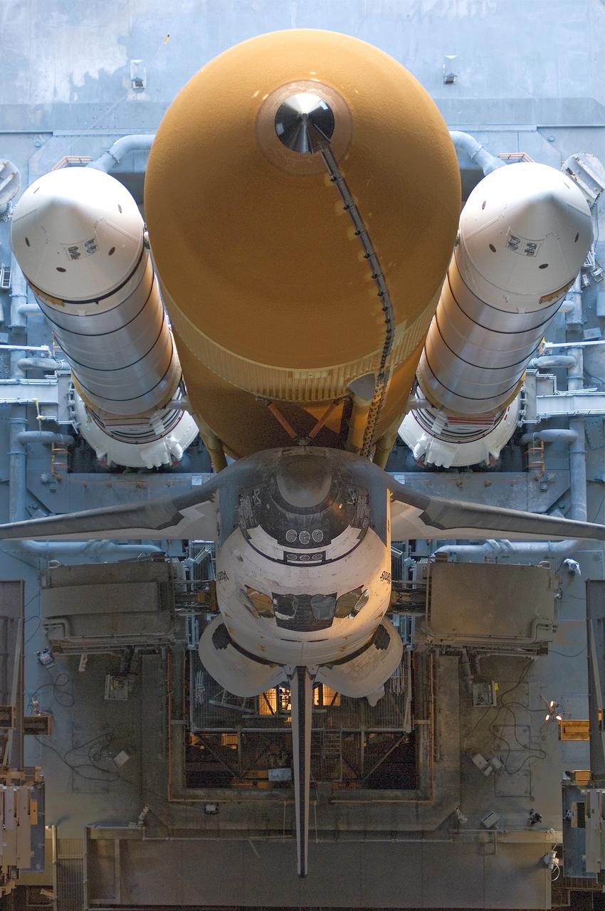
Space Shuttle Atlantis, atop the mobile launcher platform, rolls back to high bay 1 of the Vehicle Assembly Building in order to evaluate the damage received after a severe thunderstorm.
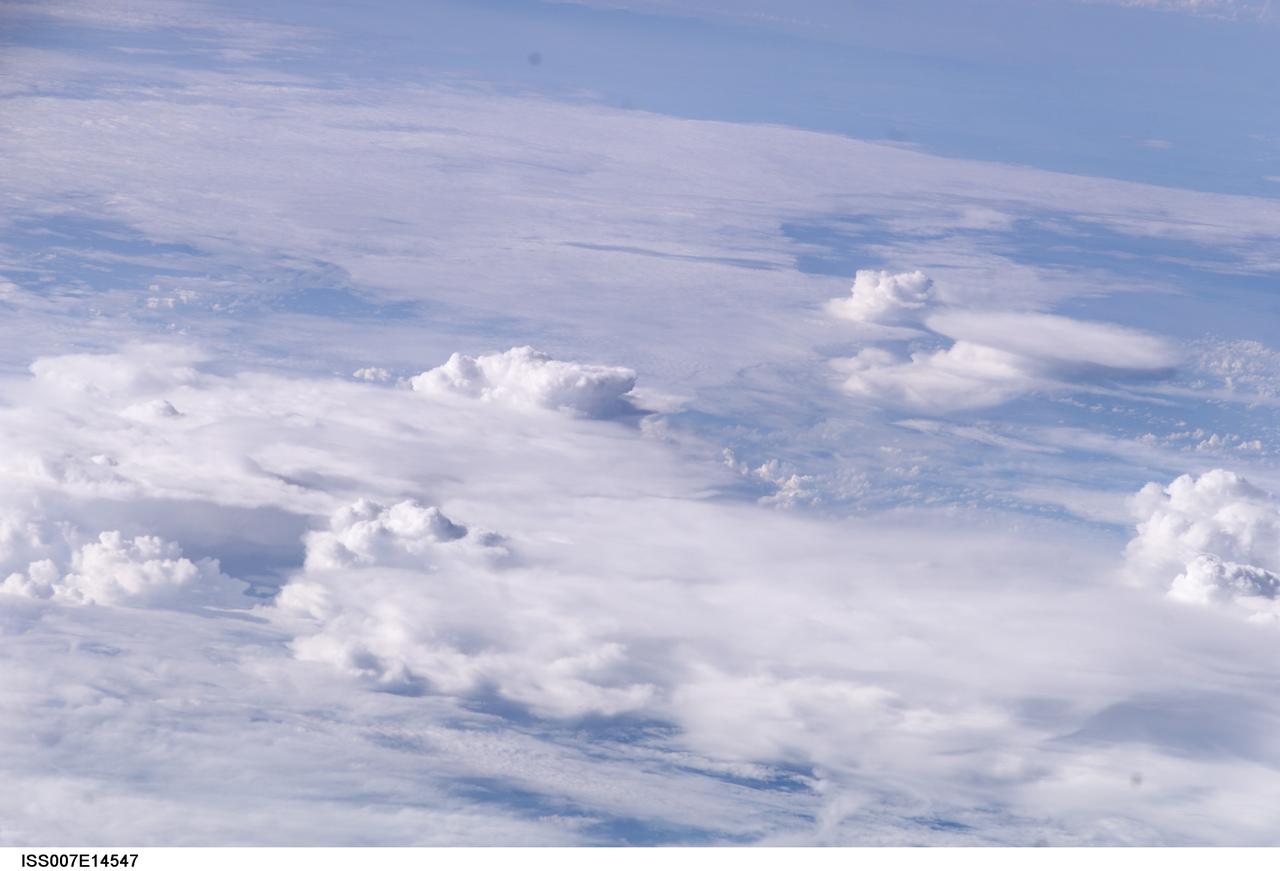
ISS007-E-14547 (8 September 2003) --- This view featuring thunderstorms over the east coast of the United States was taken by an Expedition 7 crewmember onboard the International Space Station (ISS).
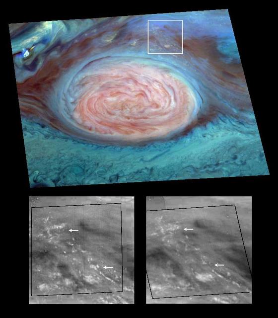
Scientists have spotted what appear to be thunderheads on Jupiter bright white cumulus clouds similar to those that bring thunderstorms on Earth - at the outer edges of Jupiter's Great Red Spot. Images from NASA's Galileo spacecraft now in orbit around Jupiter are providing new evidence that thunderstorms may be an important source of energy for Jupiter's winds that blow at more than 500 kilometers per hour (about 300 miles per hour). The photos were taken by Galileo's solid state imager camera on June 26, 1996 at a range of about 1.4 million kilometers (about 860,000 miles). The image at top is a mosaic of multiple images taken through near-infrared filters. False coloring in the image reveals cloud-top heights. High, thick clouds are white and high, thin clouds are pink. Low-altitude clouds are blue. The two black-and-white images at bottom are enlargements of the boxed area; the one on the right was taken 70 minutes after the image on the left. The arrows show where clouds have formed or dissipated in the short time between the images. The smallest clouds are tens of kilometers across. On Earth, moist convection in thunderstorms is a pathway through which solar energy, deposited at the surface, is transported and delivered to the atmosphere. Scientists at the California Institute of Technology analyzing data from Galileo believe that water, the most likely candidate for what composes these clouds on Jupiter, may be more abundant at the site seen here than at the Galileo Probe entry site, which was found to be unexpectedly dry. http://photojournal.jpl.nasa.gov/catalog/PIA00506
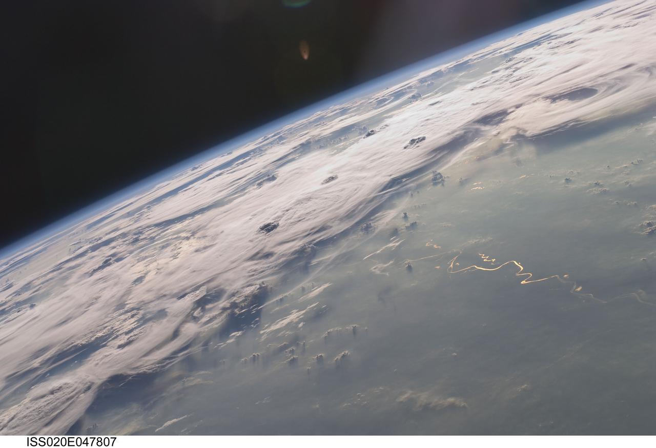
ISS020-E-047807 (6 Oct. 2009) --- Thunderstorms on the Brazilian horizon are featured in this image photographed by an Expedition 20 crew member on the International Space Station. A picturesque line of thunderstorms and numerous circular cloud patterns filled the view as the station crew members looked out at the limb and atmosphere (blue line on the horizon) of Earth. This region displayed in the photograph (top) includes an unstable, active atmosphere forming a large area of cumulonimbus clouds in various stages of development. The crew was looking west southwestward from the Amazon Basin, along the Rio Madeira, toward Bolivia when the image was taken. The distinctive circular patterns of the clouds in this view are likely caused by the aging of thunderstorms. Such ring structures often form during the final stages of a storm?s development as their centers collapse. Sunglint is visible on the waters of the Rio Madeira and Lago Acara in the Amazon Basin. Widespread haze over the basin gives the reflected light an orange hue. The Rio Madeira flows northward and joins the Amazon River on its path to the Atlantic Ocean. Scientists believe that a large smoke plume near the bottom center of the image may explain one source of the haze.
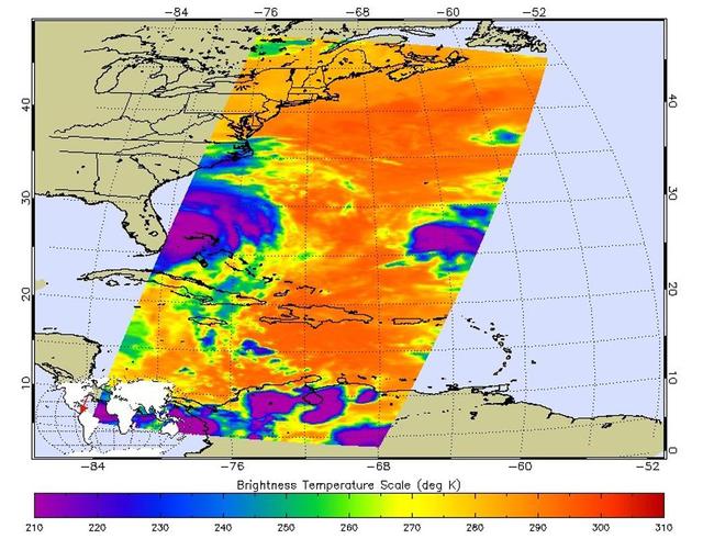
This false-color image shows Hurricane Isabel viewed by the AIRS and AMSU-A instruments at 1:30 EDT in the morning of Thursday September 18, 2003. Isabel will be ashore within 12 hours, bringing widespread flooding and destructive winds. In figure 1 on the left, data retrieved by the AIRS infrared sensor shows the hurricane's eye as the small ring of pale blue near the upper left corner of the image. The dark blue band around the eye shows the cold tops of hundreds of powerful thunderstorms. These storms are embedded in the 120 mile per hour winds swirling counterclockwise around Isabel's eye. Cape Hatteras is the finger of land north-northwest of the eye. Isabel's winds will soon push ashore a 4- to 8-foot high mound of 'storm surge' and accompanying high surf, leading to flooding of Cape Hatteras and other islands of North Carolina's Outer Banks. Also seen in the image are several organized bands of cold, (blue) thunderstorm tops being pulled into the storm center. Other thunderstorm are forming north of the islands of Jamaica, Cuba, Hispaniola and Puerto Rico near the bottom of the picture. http://photojournal.jpl.nasa.gov/catalog/PIA00428
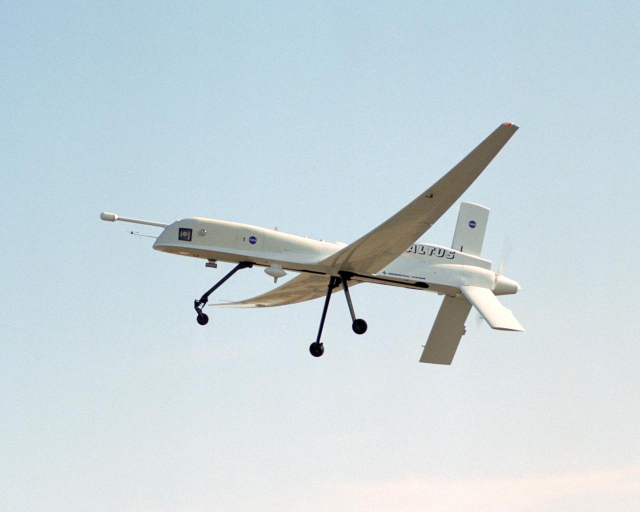
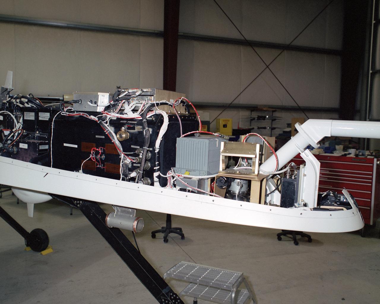
A NASA team studying the causes of electrical storms and their effects on our home planet achieved a milestone on August 21, 2002, completing the study's longest-duration research flight and monitoring four thunderstorms in succession. Based at the Naval Air Station Key West, Florida, researchers with the Altus Cumulus Electrification Study (ACES) used the Altus II remotely-piloted aircraft to study thunderstorms in the Atlantic Ocean off Key West and the west of the Everglades. The ACES lightning study used the Altus II twin turbo uninhabited aerial vehicle, built by General Atomics Aeronautical Systems, Inc. of San Diego. The Altus II was chosen for its slow flight speed of 75 to 100 knots (80 to 115 mph), long endurance, and high-altitude flight (up to 65,000 feet). These qualities gave the Altus II the ability to fly near and around thunderstorms for long periods of time, allowing investigations to be to be conducted over the entire life cycle of storms. The vehicle has a wing span of 55 feet and a payload capacity of over 300 lbs. With dual goals of gathering weather data safely and testing the adaptability of the uninhabited aircraft, the ACES study is a collaboration among the Marshall Space Flight Center, the University of Alabama in Huntsville, NASA,s Goddard Space Flight Center in Greenbelt, Maryland, Pernsylvania State University in University Park, and General Atomics Aeronautical Systems, Inc.
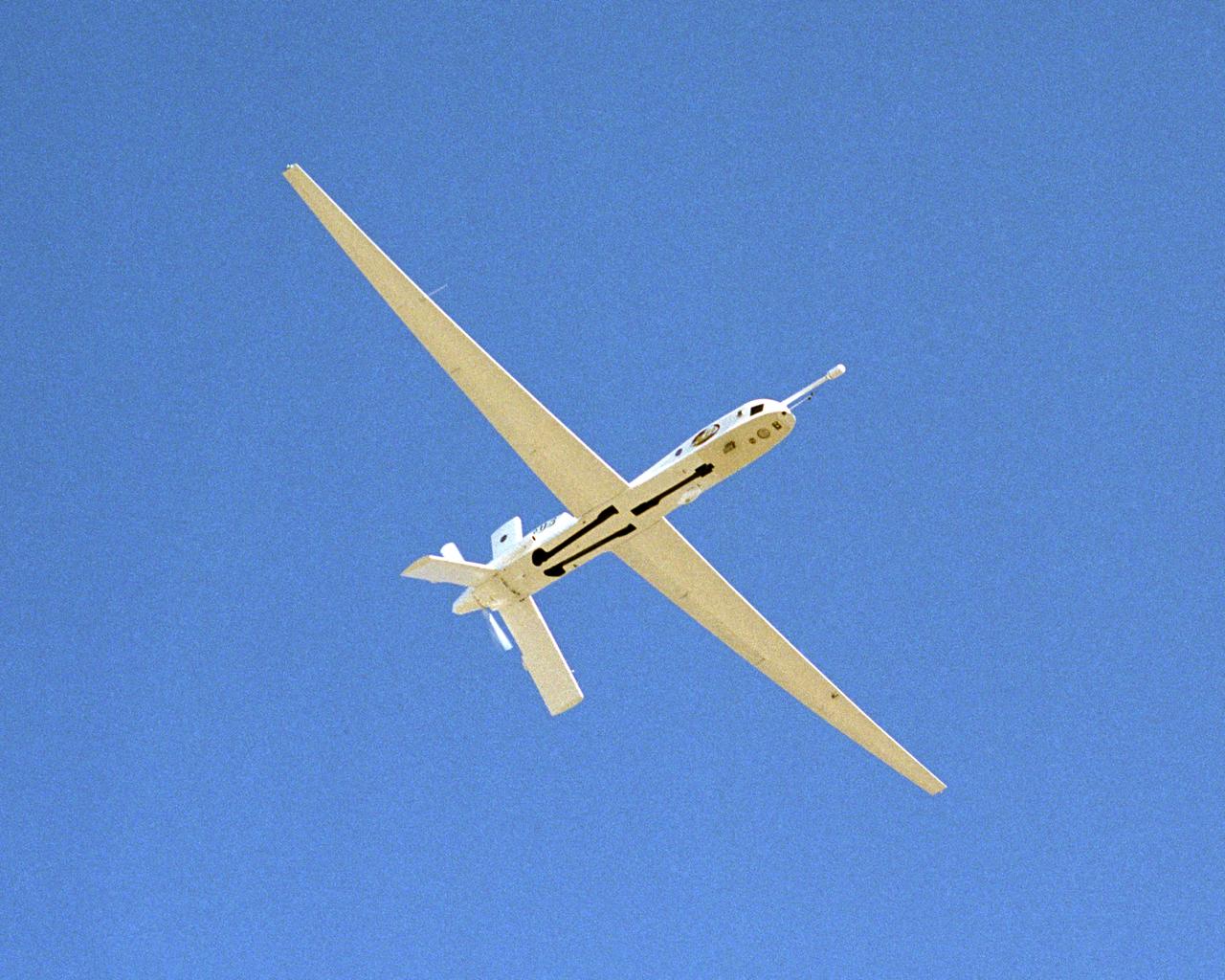
A NASA team studying the causes of electrical storms and their effects on our home planet achieved a milestone on August 21, 2002, completing the study's longest-duration research flight and monitoring four thunderstorms in succession. Based at the Naval Air Station Key West, Florida, researchers with the Altus Cumulus Electrification Study (ACES) used the Altus II remotely piloted aircraft to study thunderstorms in the Atlantic Ocean off Key West and the west of the Everglades. The ACES lightning study used the Altus II twin turbo uninhabited aerial vehicle, built by General Atomics Aeronautical Systems, Inc. of San Diego. The Altus II was chosen for its slow flight speed of 75 to 100 knots (80 to 115 mph), long endurance, and high-altitude flight (up to 65,000 feet). These qualities gave the Altus II the ability to fly near and around thunderstorms for long periods of time, allowing investigations to be conducted over the entire life cycle of storms. The vehicle has a wing span of 55 feet and a payload capacity of over 300 lbs. With dual goals of gathering weather data safely and testing the adaptability of the uninhabited aircraft, the ACES study is a collaboration among the Marshall Space Flight Center, the University of Alabama in Huntsville, NASA's Goddard Space Flight Center in Greenbelt, Maryland, Pernsylvania State University in University Park, and General Atomics Aeronautical Systems, Inc.
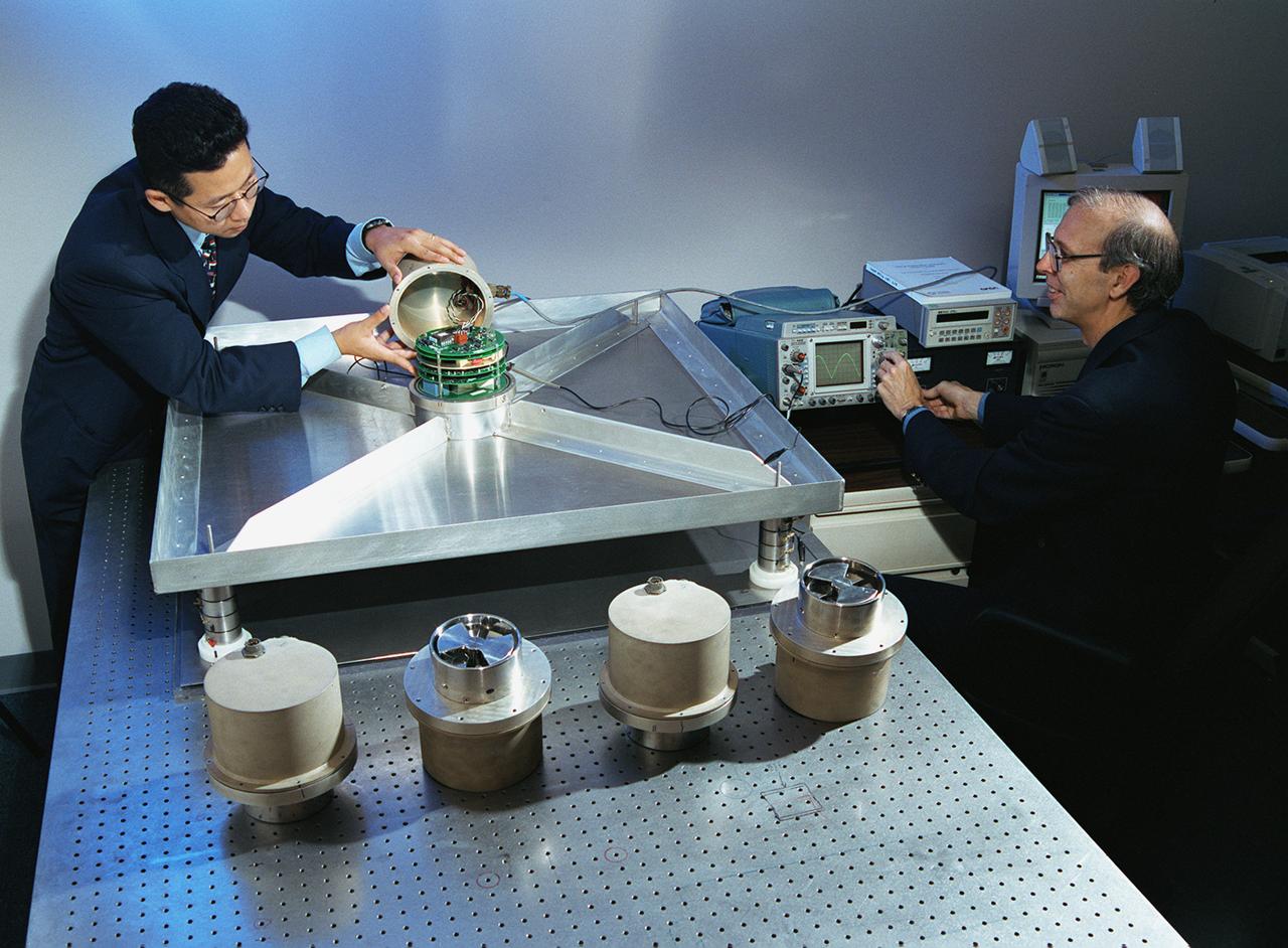
A NASA team studying the causes of electrical storms and their effects on our home planet achieved a milestone on August 21, 2002, completing the study's longest-duration research flight and monitoring four thunderstorms in succession. Radio news media can talk with Dr. Richard Blakeslee, the project's principal investigator, and Tony Kim, project manager at the Marshall Space Flight Center (MSFC), about their results and how their work will help improve future weather forecasting ability. Based at the Naval Air Station Key West, Florida, researchers with the Altus Cumulus Electrification Study (ACES) used the Altus II remotely- piloted aircraft to study a thunderstorm in the Atlantic Ocean off Key West, two storms at the western edge of the Everglades, and a large storm over the northwestern corner of the Everglades. This photograph shows Tony Kim And Dr. Richard Blakeslee of MSFC testing aircraft sensors that would be used to measure the electric fields produced by thunderstorm as part of NASA's ACES. With dual goals of gathering weather data safely and testing the adaptability of the uninhabited aircraft, the ACES study is a collaboration among the MSFC, the University of Alabama in Huntsville, NASA's Goddard Space Flight Center in Greenbelt, Maryland, Pernsylvania State University in University Park, and General Atomics Aeronautical Systems, Inc.
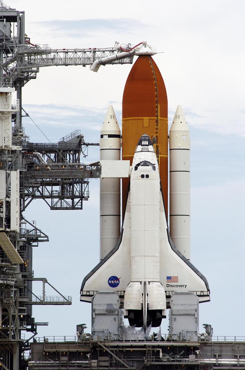
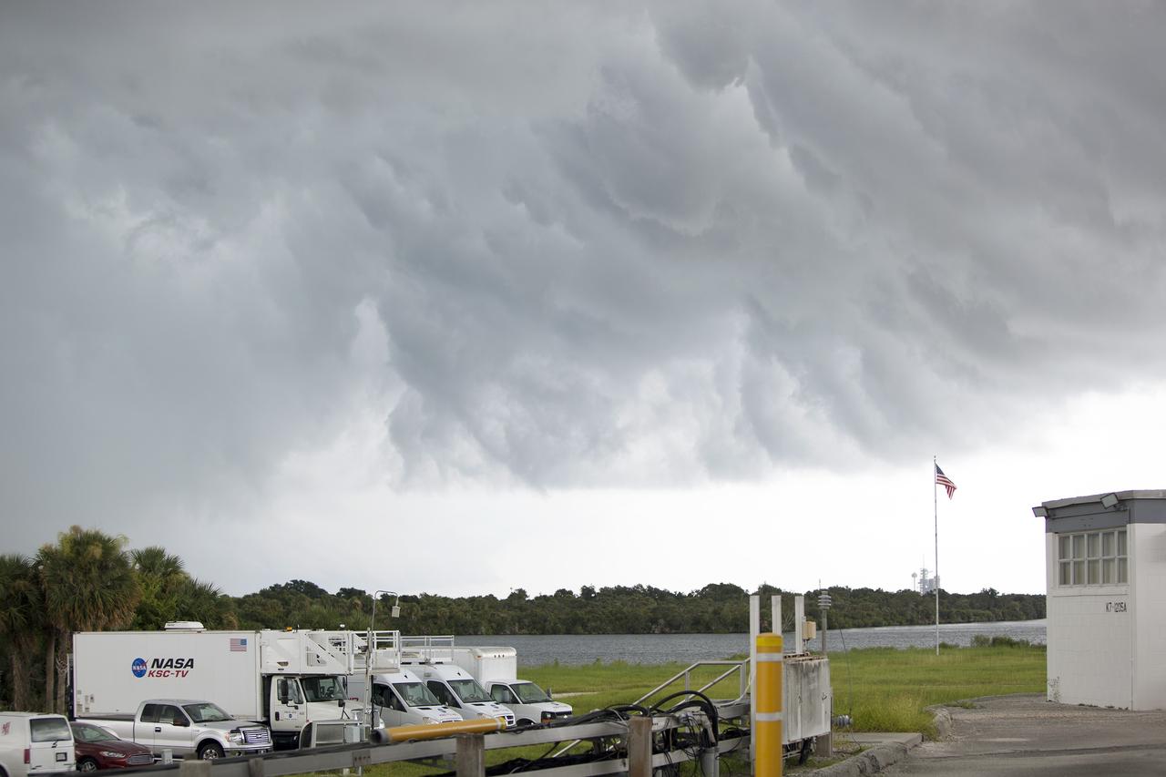
KENNEDY SPACE CENTER, FLA. - Space Shuttle Discovery remains on Launch Pad 39B after the countdown was halted for the launch of mission STS-121. The launch was scrubbed due to the presence of anvil clouds and thunderstorms within 20 miles of the launch site and postponed for 24 hours. Photo credit: Nikon/Scott Andrews
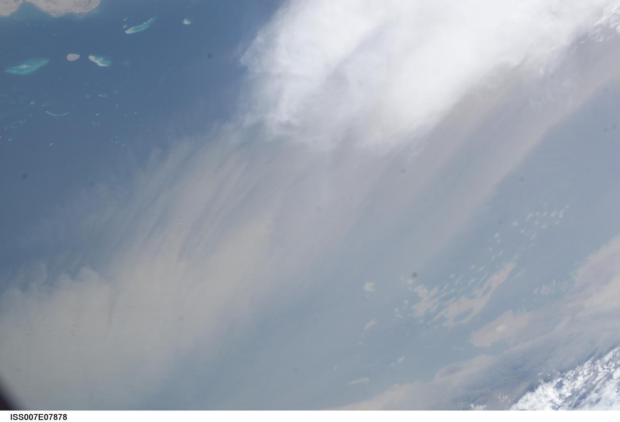
ISS007-E-07878 (22 June 2003) --- This image, photographed by an Expedition 7 crewmember onboard the International Space Station (ISS), was merged with image ISS007-E-07872 to create a mosaic of a dust storm and thunderstorm over the Red Sea. The mosaic can be viewed on http://eol.jsc.nasa.gov
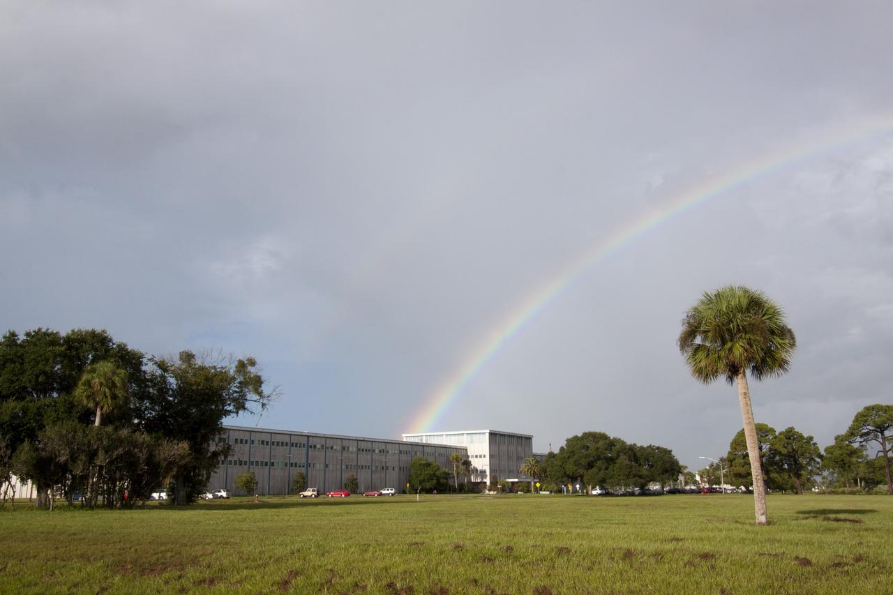
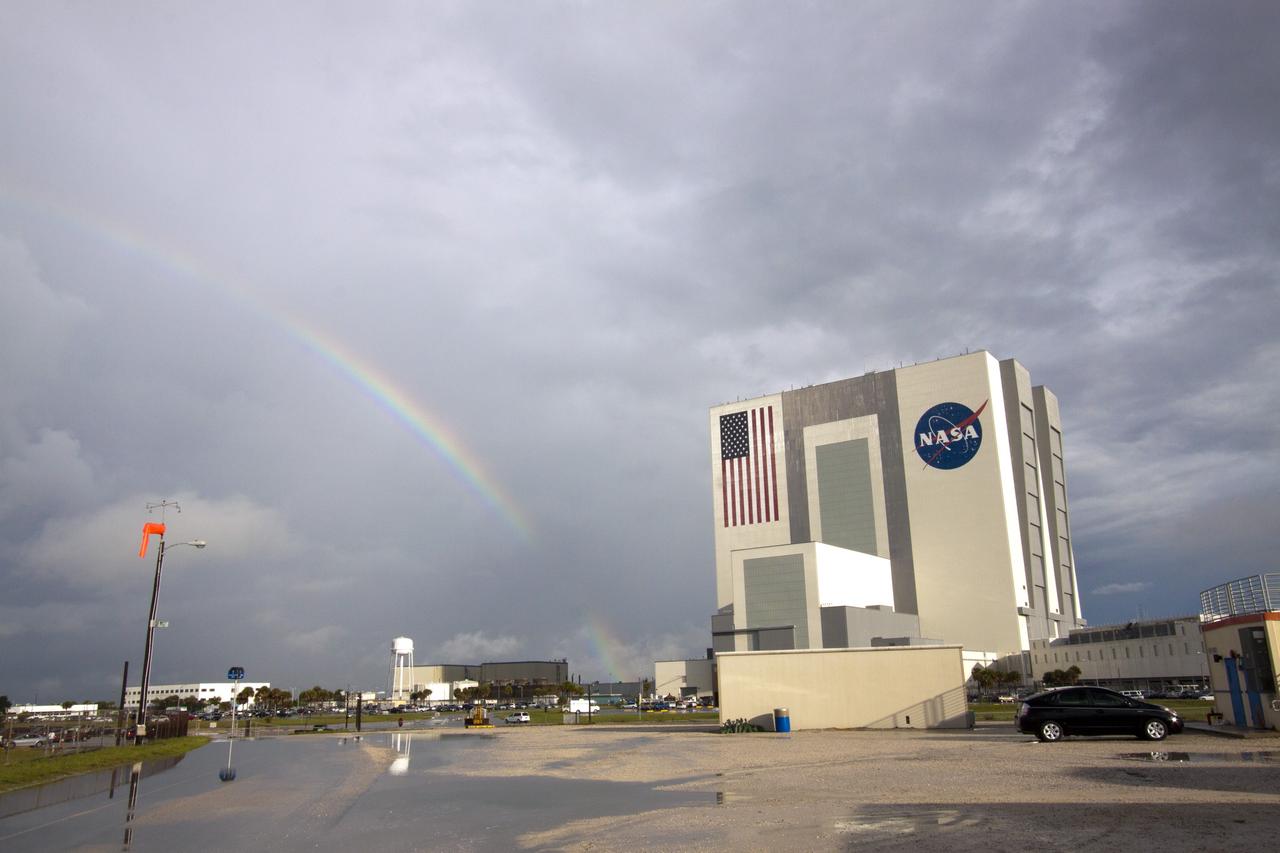
CAPE CANAVERAL, Fla. -- As the sun was rising over NASA's Kennedy Space Center in Florida, an early morning rain shower caused a meteorological and optical rainbow show over the Headquarters building. Florida's Space Coast often is the scene of showers and thunderstorms during the summer months. Photo credit: NASA/Jack Pfaller
ISS042E237320 (02/09/2015) ---A weather observation image taken from the International Space Station tweeted out to social media fans by NASA astronaut Terry Virts. He added this comment: "Enormous #thunderstorm over the jungles of #Africa".
CAPE CANAVERAL, Fla. -- As the sun was rising over NASA's Kennedy Space Center in Florida, an early morning rain shower caused a meteorological and optical rainbow show next to the Vehicle Assembly Building. Florida's Space Coast often is the scene of showers and thunderstorms during the summer months. Photo credit: NASA/Jack Pfaller
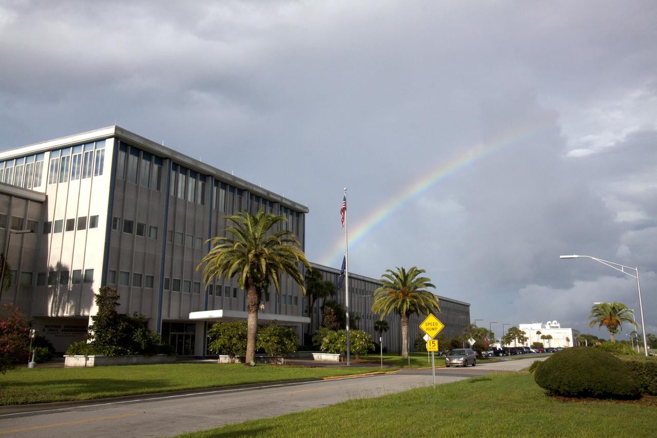
CAPE CANAVERAL, Fla. -- As the sun was rising over NASA's Kennedy Space Center in Florida, an early morning rain shower caused a meteorological and optical rainbow show over the Headquarters building. Florida's Space Coast often is the scene of showers and thunderstorms during the summer months. Photo credit: NASA/Jack Pfaller
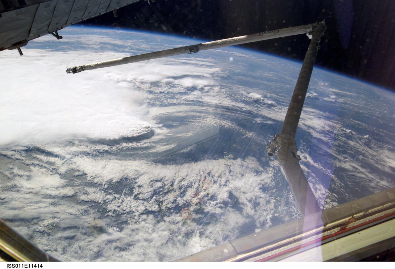
ISS011-E-11414 (2 August 2005) --- A line of thunderstorms form the backdrop for this view of the extended Space Shuttle Discovery’s remote manipulator system (RMS) robotic arm while docked to the International Space Station during the STS-114 mission.
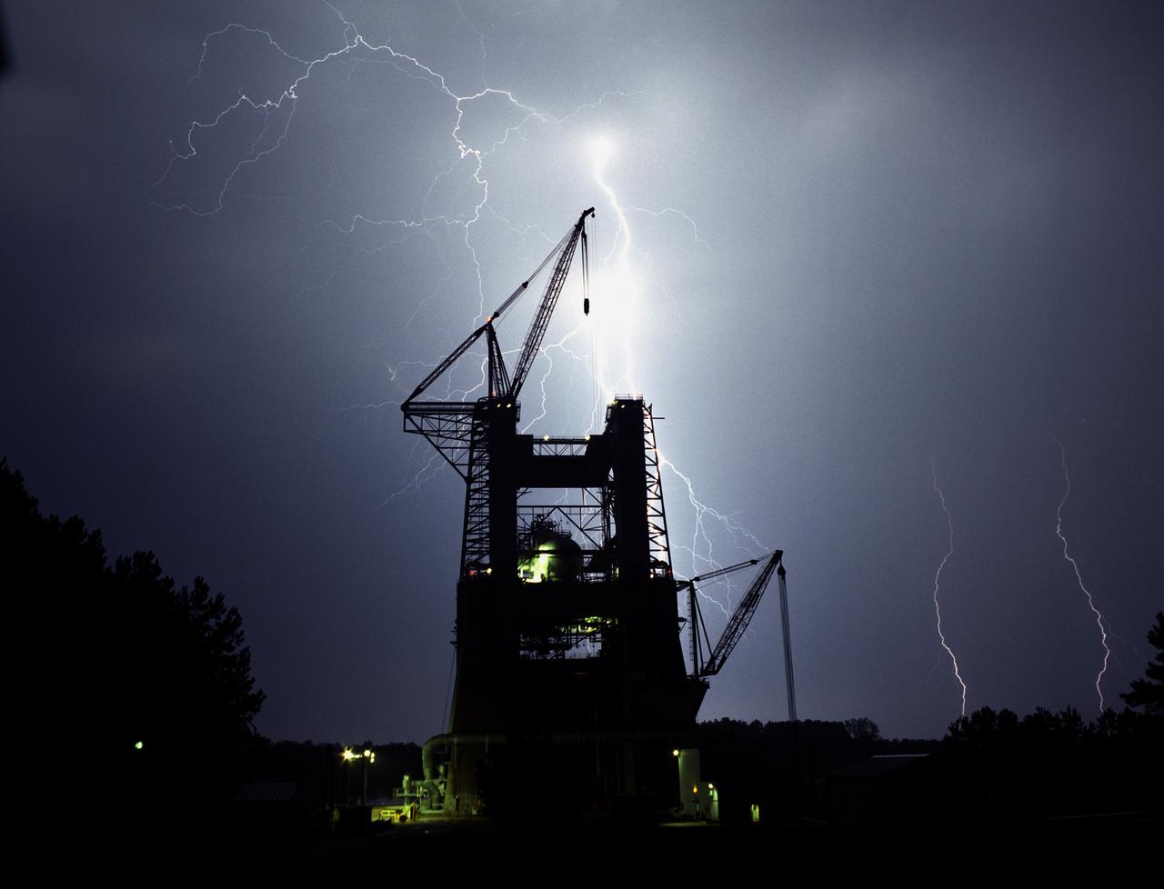
Multiple lightning bolts struck the Technology Test Bed, formerly the S-IC Static Test Stand, at the Marshall Space Flight Center (MSFC) during a thunderstorm. This spectacular image of lightning was photographed by MSFC photographer Dernis Olive on August 29, 1990.
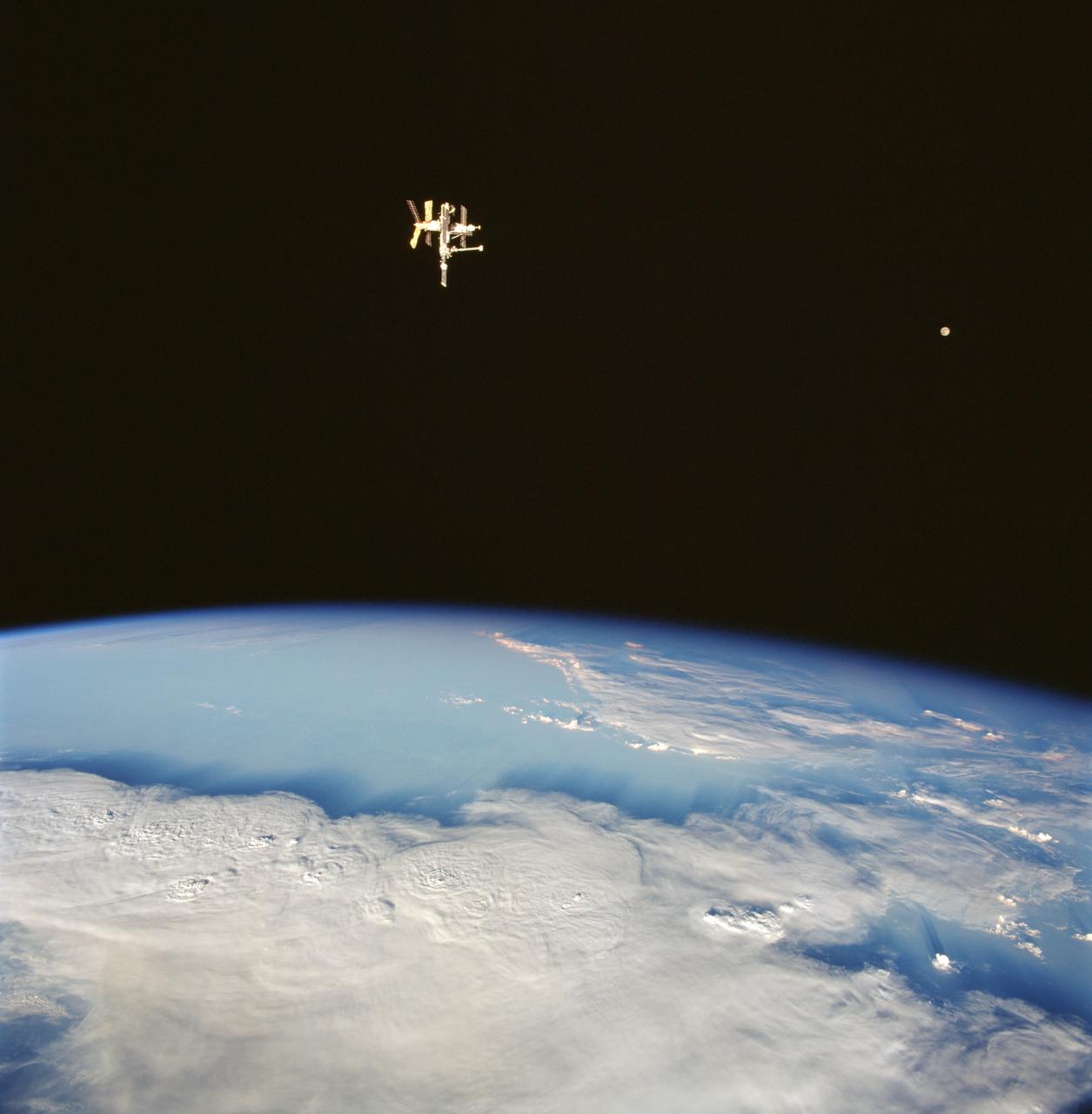
STS091-711-028 (2-12 June 1998) --- Russia's Mir space station and the moon share a 70mm frame exposed by one of the STS-91 crew members aboard the Earth-orbiting Space Shuttle Discovery as it passed over a line of heavy thunderstorms on Earth.
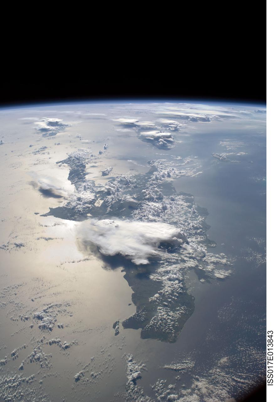
ISS017-E-013843 (19 Aug. 2008) --- A panoramic view of the island of Hispaniola in the foreground and Cuba extending to over the horizon. The sunglint is illuminating Haiti and the Dominican Republic while the thunderstorms persist in the late afternoon of the summertime day. Taken by the Expedition 17 crew onboard the ISS on Aug 19, 2008 with a 28 mm lens.
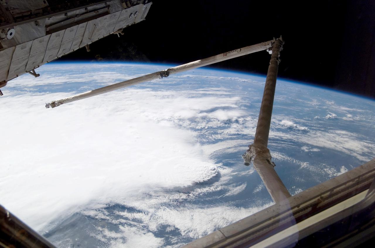
ISS011-E-11416 (2 August 2005) --- A line of thunderstorms form the backdrop for this view of the extended Space Shuttle Discovery;s remote manipulator system (RMS) robotic arm while docked to the International Space Station during the STS-114 mission.

STS052-152-047 (22 Oct- 1 Nov 1992) --- The Kalahari Desert had not seen any significant rainfall for months before the launch of STS-52. Here, Shuttle astronauts have captured the onset of the (Southern Hemisphere) summer monsoon over the Kalahari Desert, as illustrated by the large thunderstorm towers poking up through the sun's terminator. The summer monsoon, with its associated thunderstorms, generally lasts from November through March. Scientist observers of this area report that the summer monsoon contributes most of the annual rainfall to this environmentally sensitive area. Shuttle nadir position: 28.0 degrees south, 25.1 degrees east. The center of the scene is 22.0 degrees south, 25.0 degrees east, 16:20:04 GMT.
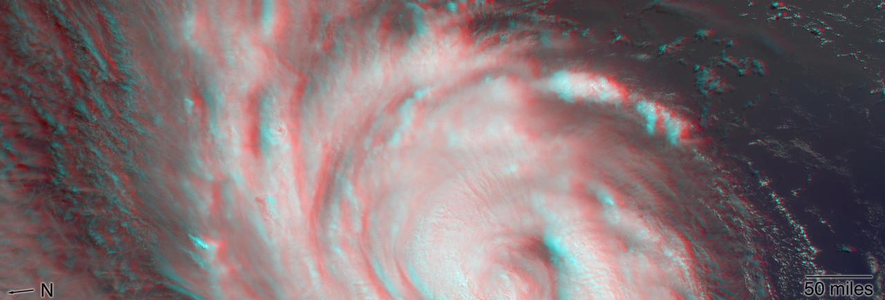
NASA's Multi-angle Imaging SpectroRadiometer (MISR) passed over Hurricane Florence as it approached the eastern coast of the United States on Thursday, September 13, 2018. At the time the image was acquired, Florence was a large Category 2 storm and coastal areas were already being hit with tropical-storm-force winds. The MISR instrument, flying onboard NASA's Terra satellite, carries nine cameras that observe Earth at different angles. It takes about seven minutes for all the cameras to observe the same location. This stereo anaglyph shows a 3D view of Florence. You will need red-blue 3D glasses, with the red lens placed over the left eye, to view the effect. The anaglyph shows the high clouds associated with strong thunderstorms in the eyewall of hurricane and individual strong thunderstorms in the outer rain bands. These smaller storms can sometimes spawn tornadoes. https://photojournal.jpl.nasa.gov/catalog/PIA22701
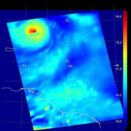
This false-color image shows the amount of atmospheric water vapor observed by AIRS two weeks prior to the passage of Hurricane Isabel, and then when it was a Category 5 storm. The region shown includes parts of South America and the West Indies. Puerto Rico is the large island below the upper left corner. Total water vapor represents the depth of a layer if all the water vapor in the atmosphere were to condense and fall to the surface. The color bar on the right sides of the plots give the thickness of this layer in millimeters (mm). The first image, from August 28, shows typical tropical water vapor amounts over the ocean: between roughly 25 and 50 mm, or 1 to 2 inches. The highest values of roughly 80 mm, seen as a red blob over South America, corresponds to intense thunderstorms. Thunderstorms pull in water vapor from surrounding regions and concentrate it, with much of it then falling as rain. http://photojournal.jpl.nasa.gov/catalog/PIA00430
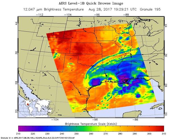
The latest infrared image from NASA's Atmospheric Infrared Sounder (AIRS) instrument aboard NASA's Aqua satellite illustrates the growing flood threat from now Tropical Storm Harvey. In the false-color image, acquired at 2:29 p.m. CDT (19:29 UTC) on Aug. 28, 2017, a large area of dark blue and purple centered along the southeastern Texas coast denotes the coldest cloud top temperatures and strongest thunderstorms. A second area of intense precipitation is visible over southeastern Louisiana. Harvey has reemerged over the Gulf of Mexico, but the National Hurricane Center forecasts only a small amount of strengthening before the storm moves slowly north and inland again. https://photojournal.jpl.nasa.gov/catalog/PIA21885
STS109-345-032 (1-12 March 2002) --- One of the astronauts aboard the Space Shuttle Columbia photographed this west-looking view featuring the profile of the atmosphere and the setting sun. The shuttle was located over the Java Sea to the south of Kalimantan (Borneo) in Indonesia when this image was acquired. Visible to the right of the setting sun are cloud tops from some thunderstorms. The sun's reflection (bright spot over the setting sun) can be seen off the upper layers of the earth's atmosphere.

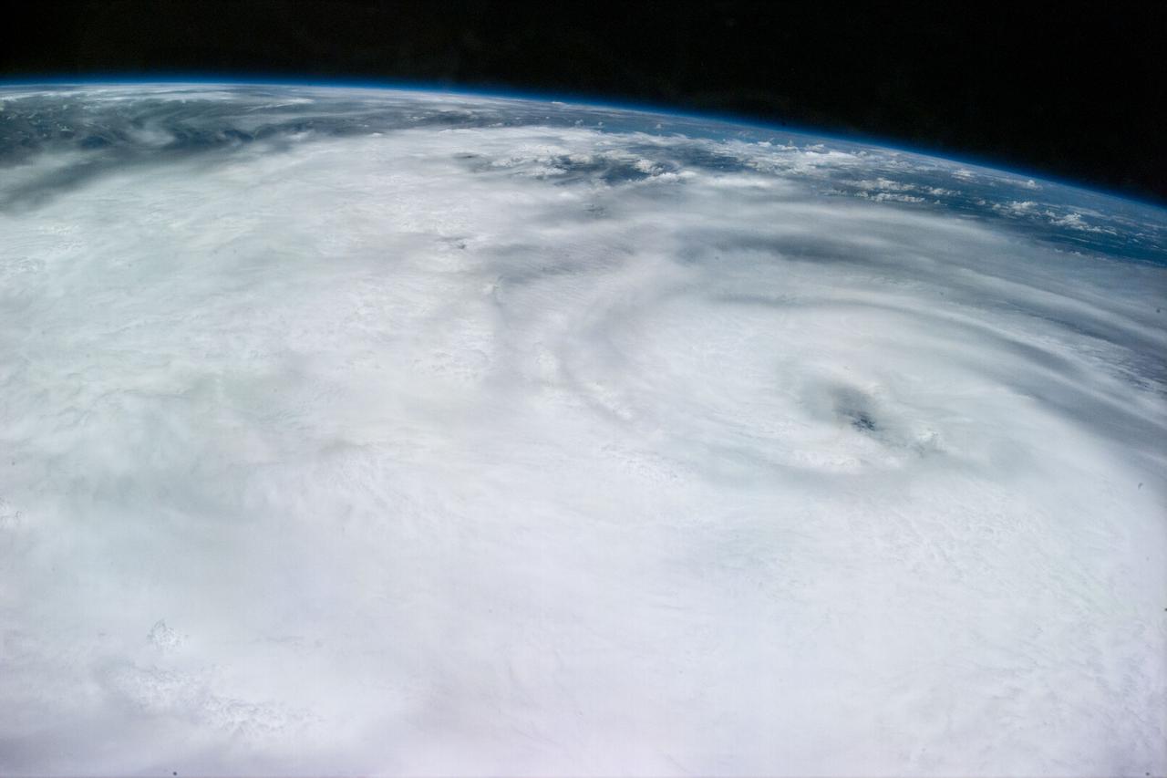
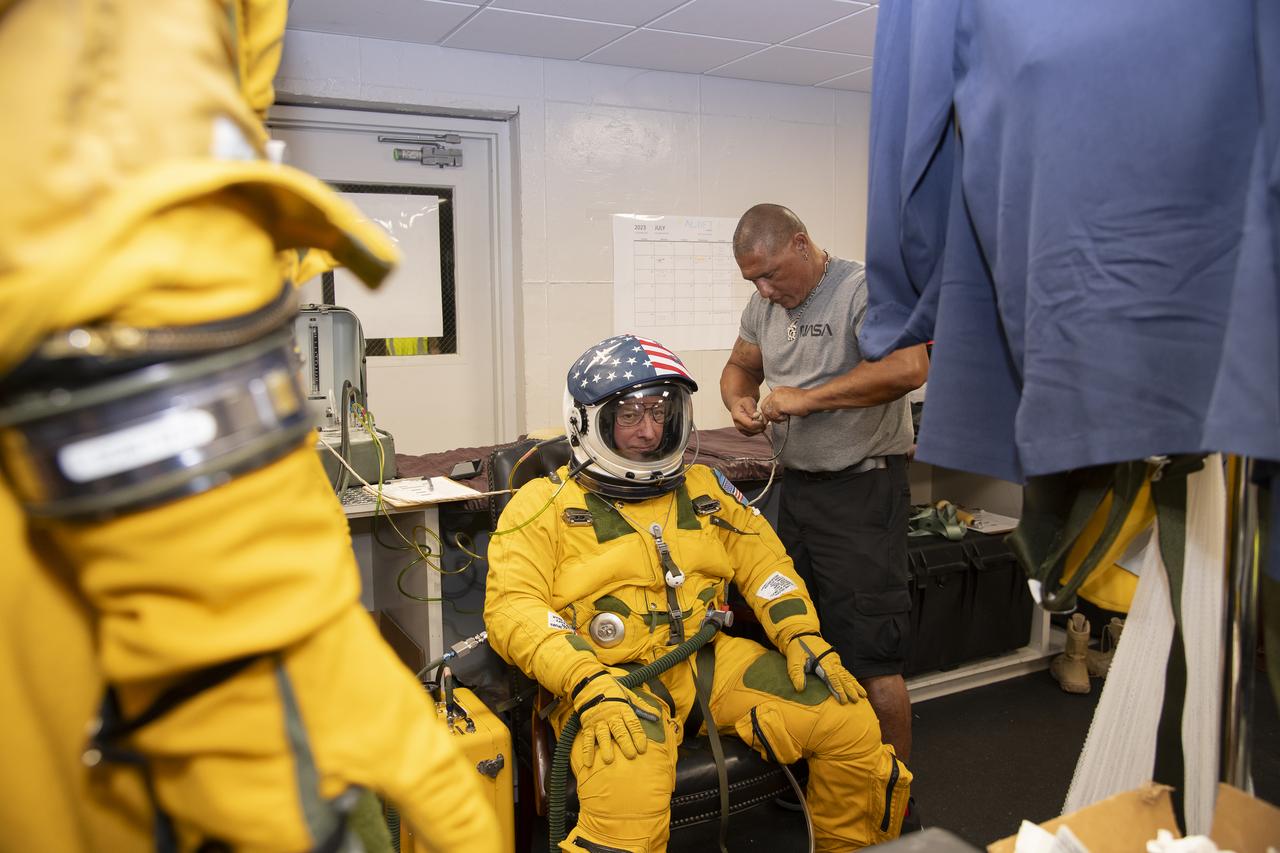
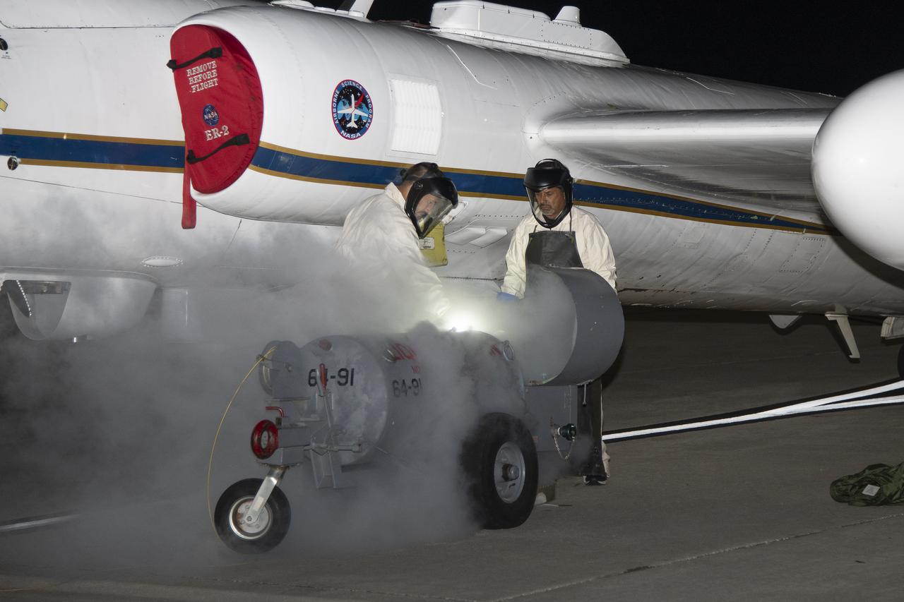
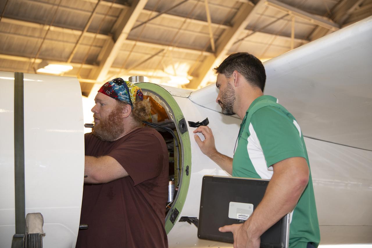
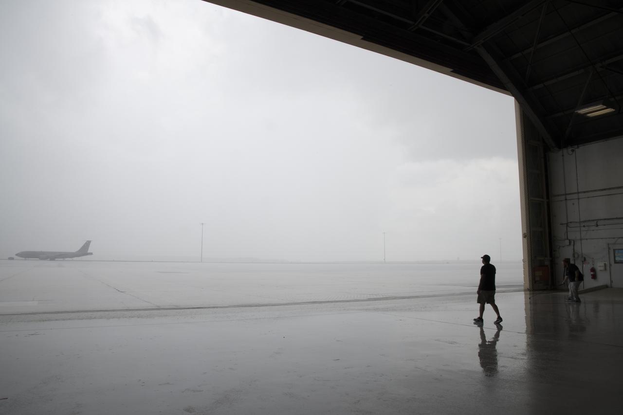
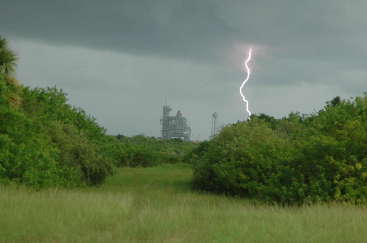
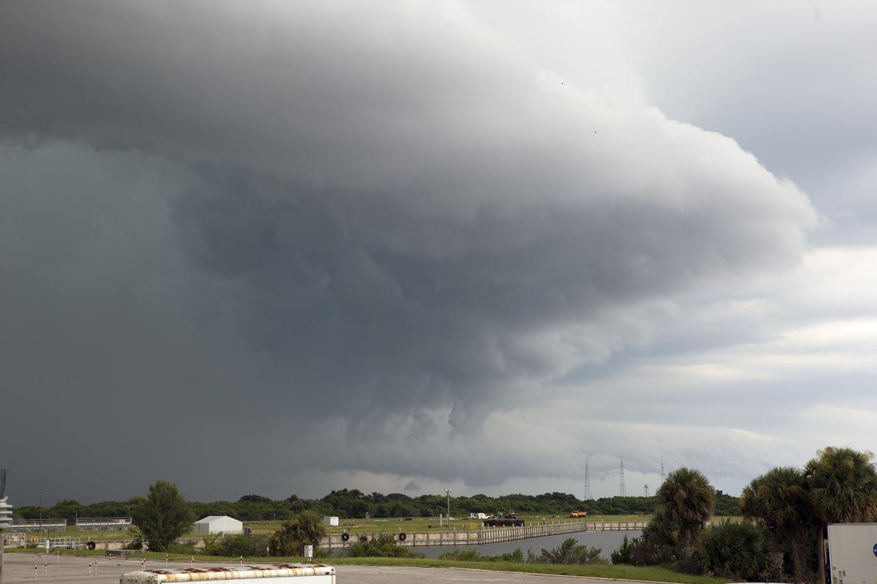
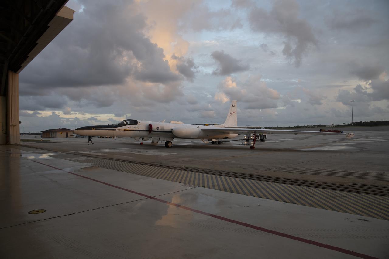
The ALOFT mission, Airborne Lightning Observatory for Fly’s eye simulator and Terrestrial gamma ray flashes, is a collaboration between NASA and the University of Bergen, Norway. NASA Armstrong Flight Research Center’s ER-2 aircraft flies just above the height of thunderclouds over the Floridian and Caribbean coastlines to collect data about lightning glows and terrestrial gamma ray flashes. Scientists expect to collect more accurate data than ever before that can advance the study of high-energy radiation emissions from thunderstorms.
STS109-729-072 (9 March 2002) --- Looking westward, one of the STS-109 crew members photographed the newly serviced and upgraded Hubble Space Telescope (HST) near the earth's limb to the upper right of the center of this 70mm image. The Space Shuttle Columbia was located over the Atlantic Ocean southwest of the Cape Verde Islands when this image was acquired. Low to mid-altitude clouds are visible across the image. Some thunderstorms can be seen near the left center of the image as the sun reflects off the higher cloud tops.

KENNEDY SPACE CENTER, FLA. -- In the Vehicle Assembly Building, workers check foam repairs on Atlantis' external tank. In late February, Atlantis' external tank received hail damage during a severe thunderstorm that passed through the Kennedy Space Center Launch Complex 39 area. The hail caused visible divots in the giant tank's foam insulation as well as minor surface damage to about 26 heat shield tiles on the shuttle's left wing. The launch now is targeted for June 8. Photo credit: NASA/Jack Pfaller
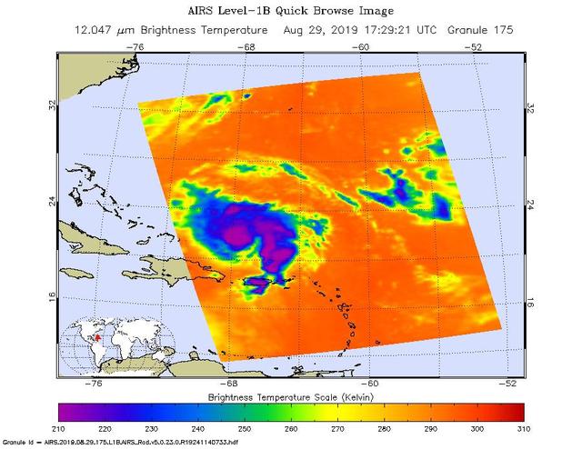
An infrared image of Hurricane Dorian, as seen by the AIRS instrument aboard NASA's Aqua satellite at 1:30 p.m. EDT (10:30 a.m. PDT) on Aug. 29, 2019. The large purple areas are cold clouds, carried high into the atmosphere by deep thunderstorms. Blue and green show warmer areas with less rain clouds, while orange and red represent mostly cloud-free air. https://photojournal.jpl.nasa.gov/catalog/PIA23358

The ALOFT mission, Airborne Lightning Observatory for Fly’s eye simulator and Terrestrial gamma ray flashes, is a collaboration between NASA and the University of Bergen, Norway. NASA Armstrong Flight Research Center’s ER-2 aircraft flies just above the height of thunderclouds over the Floridian and Caribbean coastlines to collect data about lightning glows and terrestrial gamma ray flashes. Scientists expect to collect more accurate data than ever before that can advance the study of high-energy radiation emissions from thunderstorms.

The ALOFT mission, Airborne Lightning Observatory for Fly’s eye simulator and Terrestrial gamma ray flashes, is a collaboration between NASA and the University of Bergen, Norway. NASA Armstrong Flight Research Center’s ER-2 aircraft flies just above the height of thunderclouds over the Floridian and Caribbean coastlines to collect data about lightning glows and terrestrial gamma ray flashes. Scientists expect to collect more accurate data than ever before that can advance the study of high-energy radiation emissions from thunderstorms.

KENNEDY SPACE CENTER, FLA. -- In Highbay 1 inside the Vehicle Assembly Building, technicians look at hail damage on the external tank. A severe thunderstorm with golf ball-sized hail caused visible divots in the giant tank's foam insulation and minor surface damage to about 26 heat shield tiles on the shuttle's left wing. A new target launch date has not been determined, but teams will focus on preparing Atlantis for liftoff in late April on mission STS-117. Photo credit: NASA/Jim Grossmann
S94-E-5027 (9 July 1997)--- Hurricane Dolores located about 20 degrees southwest of the tip of the Baja Peninsula in the eastern Pacific supported winds of 90 knots with gust of 100 knots on July 9, 1997. The photograph was taken through overhead windows on the aft flight deck of the Earth-orbiting Space Shuttle Columbia. Notice the thunderstorms in the bands leading into the eye at lower levels and the lighter cirrus clouds coming from the outflow out of the eye at higher levels.

The ALOFT mission, Airborne Lightning Observatory for Fly’s eye simulator and Terrestrial gamma ray flashes, is a collaboration between NASA and the University of Bergen, Norway. NASA Armstrong Flight Research Center’s ER-2 aircraft flies just above the height of thunderclouds over the Floridian and Caribbean coastlines to collect data about lightning glows and terrestrial gamma ray flashes. Scientists expect to collect more accurate data than ever before that can advance the study of high-energy radiation emissions from thunderstorms.

The ALOFT mission, Airborne Lightning Observatory for Fly’s eye simulator and Terrestrial gamma ray flashes, is a collaboration between NASA and the University of Bergen, Norway. NASA Armstrong Flight Research Center’s ER-2 aircraft flies just above the height of thunderclouds over the Floridian and Caribbean coastlines to collect data about lightning glows and terrestrial gamma ray flashes. Scientists expect to collect more accurate data than ever before that can advance the study of high-energy radiation emissions from thunderstorms.

The ALOFT mission, Airborne Lightning Observatory for Fly’s eye simulator and Terrestrial gamma ray flashes, is a collaboration between NASA and the University of Bergen, Norway. NASA Armstrong Flight Research Center’s ER-2 aircraft flies just above the height of thunderclouds over the Floridian and Caribbean coastlines to collect data about lightning glows and terrestrial gamma ray flashes. Scientists expect to collect more accurate data than ever before that can advance the study of high-energy radiation emissions from thunderstorms.
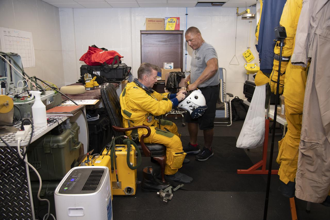
The ALOFT mission, Airborne Lightning Observatory for Fly’s eye simulator and Terrestrial gamma ray flashes, is a collaboration between NASA and the University of Bergen, Norway. NASA Armstrong Flight Research Center’s ER-2 aircraft flies just above the height of thunderclouds over the Floridian and Caribbean coastlines to collect data about lightning glows and terrestrial gamma ray flashes. Scientists expect to collect more accurate data than ever before that can advance the study of high-energy radiation emissions from thunderstorms.
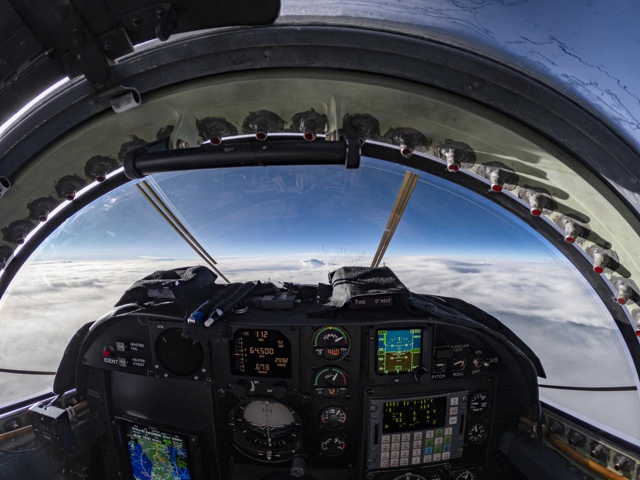
The ALOFT mission, Airborne Lightning Observatory for Fly’s eye simulator and Terrestrial gamma ray flashes, is a collaboration between NASA and the University of Bergen, Norway. NASA Armstrong Flight Research Center’s ER-2 aircraft flies just above the height of thunderclouds over the Floridian and Caribbean coastlines to collect data about lightning glows and terrestrial gamma ray flashes. Scientists expect to collect more accurate data than ever before that can advance the study of high-energy radiation emissions from thunderstorms.
The ALOFT mission, Airborne Lightning Observatory for Fly’s eye simulator and Terrestrial gamma ray flashes, is a collaboration between NASA and the University of Bergen, Norway. NASA Armstrong Flight Research Center’s ER-2 aircraft flies just above the height of thunderclouds over the Floridian and Caribbean coastlines to collect data about lightning glows and terrestrial gamma ray flashes. Scientists expect to collect more accurate data than ever before that can advance the study of high-energy radiation emissions from thunderstorms.
CAPE CANAVERAL, Fla. – The lightning suppression system on Launch Pad 39B soon may be put to the test by a thunderstorm moving through the launch complex at NASA’s Kennedy Space Center in Florida. Kennedy's Ground Support Development and Operations Program is hard at work transforming the center's facilities into a multi-user spaceport, when the weather permits. For more on Kennedy Space Center, visit http://www.nasa.gov/kennedy. Photo credit: NASA/Ben Smegelsky

The ALOFT mission, Airborne Lightning Observatory for Fly’s eye simulator and Terrestrial gamma ray flashes, is a collaboration between NASA and the University of Bergen, Norway. NASA Armstrong Flight Research Center’s ER-2 aircraft flies just above the height of thunderclouds over the Floridian and Caribbean coastlines to collect data about lightning glows and terrestrial gamma ray flashes. Scientists expect to collect more accurate data than ever before that can advance the study of high-energy radiation emissions from thunderstorms.
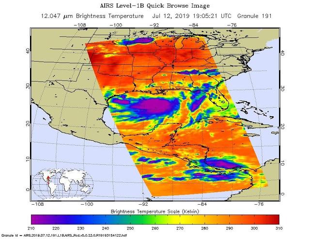
NASA's AIRS instrument imaged Tropical Storm Barry on the afternoon of July 12, 2019, a day before the storm is expected to make landfall on the Louisiana Coast. The infrared image shows very cold clouds that have been carried high into the atmosphere by deep thunderstorms in purple. These clouds are associated with heavy rainfall. Warmer areas with shallower rain clouds are shown in blue and green. And the orange and red areas represent mostly cloud-free air. https://photojournal.jpl.nasa.gov/catalog/PIA23355

The ALOFT mission, Airborne Lightning Observatory for Fly’s eye simulator and Terrestrial gamma ray flashes, is a collaboration between NASA and the University of Bergen, Norway. NASA Armstrong Flight Research Center’s ER-2 aircraft flies just above the height of thunderclouds over the Floridian and Caribbean coastlines to collect data about lightning glows and terrestrial gamma ray flashes. Scientists expect to collect more accurate data than ever before that can advance the study of high-energy radiation emissions from thunderstorms.
The ALOFT mission, Airborne Lightning Observatory for Fly’s eye simulator and Terrestrial gamma ray flashes, is a collaboration between NASA and the University of Bergen, Norway. NASA Armstrong Flight Research Center’s ER-2 aircraft flies just above the height of thunderclouds over the Floridian and Caribbean coastlines to collect data about lightning glows and terrestrial gamma ray flashes. Scientists expect to collect more accurate data than ever before that can advance the study of high-energy radiation emissions from thunderstorms.

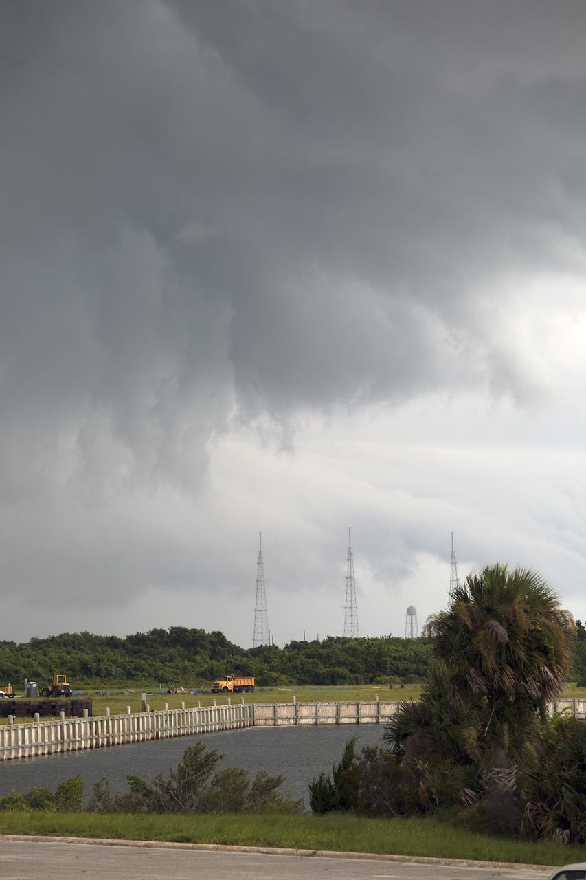
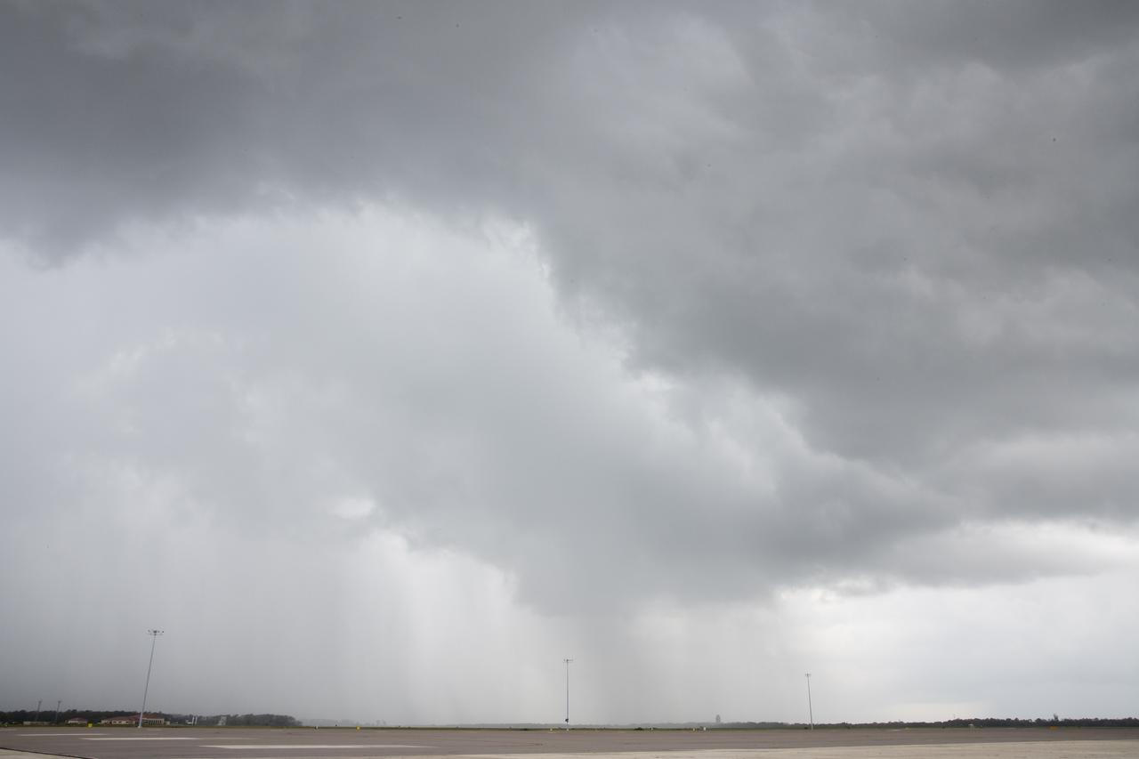
CAPE CANAVERAL, Fla. – At NASA's Kennedy Space Center in Florida, an ominous thunderstorm cloud hovers over the Vehicle Assembly Building in the Launch Complex 39 area. Severe storms associated with a frontal system are moving through Central Florida, producing strong winds, heavy rain, frequent lightning and even funnel clouds. Photo credit: NASA/Kim Shiflett
The ALOFT mission, Airborne Lightning Observatory for Fly’s eye simulator and Terrestrial gamma ray flashes, is a collaboration between NASA and the University of Bergen, Norway. NASA Armstrong Flight Research Center’s ER-2 aircraft flies just above the height of thunderclouds over the Floridian and Caribbean coastlines to collect data about lightning glows and terrestrial gamma ray flashes. Scientists expect to collect more accurate data than ever before that can advance the study of high-energy radiation emissions from thunderstorms.

The ALOFT mission, Airborne Lightning Observatory for Fly’s eye simulator and Terrestrial gamma ray flashes, is a collaboration between NASA and the University of Bergen, Norway. NASA Armstrong Flight Research Center’s ER-2 aircraft flies just above the height of thunderclouds over the Floridian and Caribbean coastlines to collect data about lightning glows and terrestrial gamma ray flashes. Scientists expect to collect more accurate data than ever before that can advance the study of high-energy radiation emissions from thunderstorms.
CAPE CANAVERAL, Fla. – A thunderstorm moving through NASA’s Kennedy Space Center in Florida hovers over the NASA Press Site. In the distance is Launch Pad 39A, recently turned over to SpaceX to support their commercial launch activities under a property agreement. Kennedy's Ground Support Development and Operations Program is hard at work transforming the center's facilities into a multi-user spaceport, when the weather permits. For more on Kennedy Space Center, visit http://www.nasa.gov/kennedy. Photo credit: NASA/Ben Smegelsky

The ALOFT mission, Airborne Lightning Observatory for Fly’s eye simulator and Terrestrial gamma ray flashes, is a collaboration between NASA and the University of Bergen, Norway. NASA Armstrong Flight Research Center’s ER-2 aircraft flies just above the height of thunderclouds over the Floridian and Caribbean coastlines to collect data about lightning glows and terrestrial gamma ray flashes. Scientists expect to collect more accurate data than ever before that can advance the study of high-energy radiation emissions from thunderstorms.
The ALOFT mission, Airborne Lightning Observatory for Fly’s eye simulator and Terrestrial gamma ray flashes, is a collaboration between NASA and the University of Bergen, Norway. NASA Armstrong Flight Research Center’s ER-2 aircraft flies just above the height of thunderclouds over the Floridian and Caribbean coastlines to collect data about lightning glows and terrestrial gamma ray flashes. Scientists expect to collect more accurate data than ever before that can advance the study of high-energy radiation emissions from thunderstorms.
The ALOFT mission, Airborne Lightning Observatory for Fly’s eye simulator and Terrestrial gamma ray flashes, is a collaboration between NASA and the University of Bergen, Norway. NASA Armstrong Flight Research Center’s ER-2 aircraft flies just above the height of thunderclouds over the Floridian and Caribbean coastlines to collect data about lightning glows and terrestrial gamma ray flashes. Scientists expect to collect more accurate data than ever before that can advance the study of high-energy radiation emissions from thunderstorms.

CAPE CANAVERAL, Fla. -- At the Kennedy Space Center in Florida, Becky Bolt, a wildlife ecologist with InoMedic Health Applications, Inc., holds one of the rescued eaglets. When a strong thunderstorm recently blew through NASA's Kennedy Space Center in Florida on March 24, two eagles fell to the ground along with their nest. Ecologists at the spaceport, who take great care to track the birds and protect their habitat, stepped in and rescued the eaglets. For more: http:__www.nasa.gov_centers_kennedy_about_sustainability_eagles_rescued.html Photo courtesy: InoMedic Health Applications_Russ Lowers

KENNEDY SPACE CENTER, FLA. -- Space Shuttle Atlantis, atop the mobile launcher platform, rolls back into high bay 1 of the Vehicle Assembly Building from Launch Pad 39A. A severe thunderstorm with golf ball-sized hail caused divots in the giant tank's foam insulation and minor surface damage to about 26 heat shield tiles on the shuttle's left wing. Photo credit: NASA/Jeff Wolfe
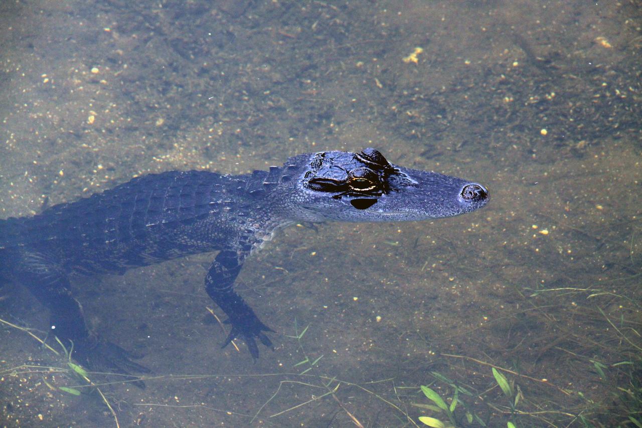
CAPE CANAVERAL, Fla. – A baby alligator is unaware that the water saturating the ground is the aftermath of thunderstorms in the vicinity of NASA Kennedy Space Center’s Shuttle Landing Facility and that space shuttle Atlantis is unable to land to conclude the STS-125 mission. Alligators can be spotted in the drainage canals and other waters surrounding Kennedy. The center shares a boundary with the Merritt Island Wildlife Nature Refuge, which is a habitat for more than 310 species of birds, 25 mammals, 117 fishes and 65 amphibians and reptiles. Photo credit: NASA/Glenn Benson

The ALOFT mission, Airborne Lightning Observatory for Fly’s eye simulator and Terrestrial gamma ray flashes, is a collaboration between NASA and the University of Bergen, Norway. NASA Armstrong Flight Research Center’s ER-2 aircraft flies just above the height of thunderclouds over the Floridian and Caribbean coastlines to collect data about lightning glows and terrestrial gamma ray flashes. Scientists expect to collect more accurate data than ever before that can advance the study of high-energy radiation emissions from thunderstorms.
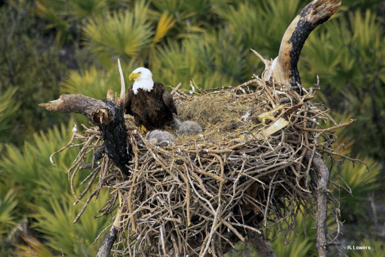
CAPE CANAVERAL, Fla. -- At the Kennedy Space Center in Florida, a bald eagle stands watch over two fledglings. The nest was in a dead, leafless pine tree, called a 'snag.' When a strong thunderstorm recently blew through NASA's Kennedy Space Center in Florida on March 24, two eagles fell to the ground along with their nest. Ecologists at the spaceport, who take great care to track the birds and protect their habitat, stepped in and rescued the eaglets. For more: http:__www.nasa.gov_centers_kennedy_about_sustainability_eagles_rescued.html Photo courtesy: InoMedic Health Applications_Russ Lowers
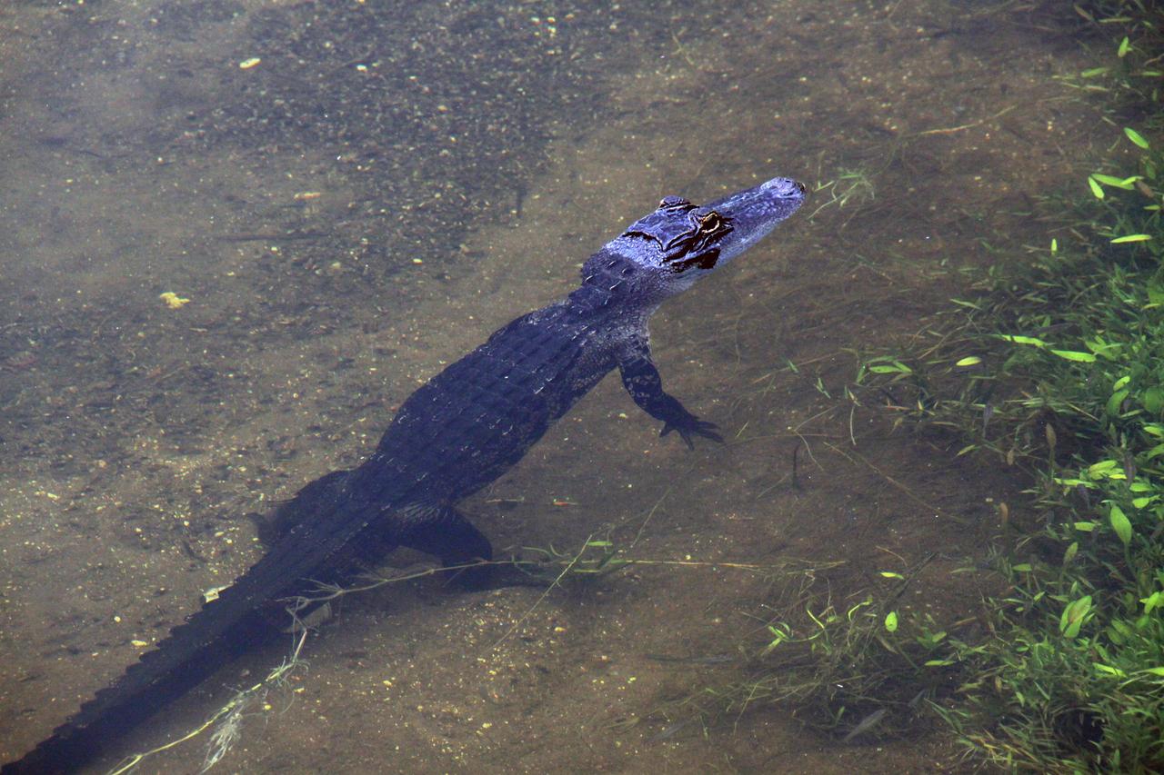
CAPE CANAVERAL, Fla. – A baby alligator is unconcerned that water saturates the ground and space shuttle Atlantis is unable to land at NASA’s Kennedy Space Center to conclude the STS-125 mission, the aftermath of thunderstorms in the vicinity of the Shuttle Landing Facility. Alligators can be spotted in the drainage canals and other waters surrounding Kennedy. The center shares a boundary with the Merritt Island Wildlife Nature Refuge, which is a habitat for more than 310 species of birds, 25 mammals, 117 fishes and 65 amphibians and reptiles. Photo credit: NASA/Glenn Benson
The ALOFT mission, Airborne Lightning Observatory for Fly’s eye simulator and Terrestrial gamma ray flashes, is a collaboration between NASA and the University of Bergen, Norway. NASA Armstrong Flight Research Center’s ER-2 aircraft flies just above the height of thunderclouds over the Floridian and Caribbean coastlines to collect data about lightning glows and terrestrial gamma ray flashes. Scientists expect to collect more accurate data than ever before that can advance the study of high-energy radiation emissions from thunderstorms.
The ALOFT mission, Airborne Lightning Observatory for Fly’s eye simulator and Terrestrial gamma ray flashes, is a collaboration between NASA and the University of Bergen, Norway. NASA Armstrong Flight Research Center’s ER-2 aircraft flies just above the height of thunderclouds over the Floridian and Caribbean coastlines to collect data about lightning glows and terrestrial gamma ray flashes. Scientists expect to collect more accurate data than ever before that can advance the study of high-energy radiation emissions from thunderstorms.

ISS043E078143 (03/31/2015) --- Astronauts on board the International Space Station captured this image on Mar. 31, 2015 of the category 5 super Typhoon Maysak which is headed toward the Philippines. The Tropical Rainfall Measuring Mission (TRMM) and Global Precipitation Measurement (GPM) satellites, both co-managed by NASA and the Japan Aerospace Exploration Agency, captured rainfall and cloud data that revealed heavy rainfall and high thunderstorms in the strengthening storm.
KENNEDY SPACE CENTER, FLA. -- A lightning strike is caught on camera during an afternoon thunderstorm at Kennedy Space Center, a common occurrence at this time of the year. In the background, the rotating service structure encloses Space Shuttle Endeavour on Launch Pad 39A. Endeavour is awaiting launch on mission STS-118. The mission is the 20th flight for orbiter Endeavour and the 22nd flight to the International Space Station. Launch is targeted for Aug. 7. Photo credit: NASA/Ken Thornsley

The ALOFT mission, Airborne Lightning Observatory for Fly’s eye simulator and Terrestrial gamma ray flashes, is a collaboration between NASA and the University of Bergen, Norway. NASA Armstrong Flight Research Center’s ER-2 aircraft flies just above the height of thunderclouds over the Floridian and Caribbean coastlines to collect data about lightning glows and terrestrial gamma ray flashes. Scientists expect to collect more accurate data than ever before that can advance the study of high-energy radiation emissions from thunderstorms.

CAPE CANAVERAL, Fla. -- An ominous storm cloud hovers over Launch Complex 39 at NASA's Kennedy Space Center in Florida. The massive, 525-foot-tall facility at left is the Vehicle Assembly Building. Florida summers are known for their dynamic weather patterns with the start of the Atlantic hurricane season and the onset of afternoon thunderstorms that bring with them heavy rain, frequent lightning and occasionally even tornadoes. Photo credit: NASA/Jim Grossmann
CAPE CANAVERAL, Fla. – A thunderstorm moving through NASA’s Kennedy Space Center in Florida approaches Launch Pad 39B, in the distance. Kennedy's Ground Support Development and Operations Program is hard at work transforming the center's facilities into a multi-user spaceport, when the weather permits. For more on Kennedy Space Center, visit http://www.nasa.gov/kennedy. Photo credit: NASA/Ben Smegelsky
The ALOFT mission, Airborne Lightning Observatory for Fly’s eye simulator and Terrestrial gamma ray flashes, is a collaboration between NASA and the University of Bergen, Norway. NASA Armstrong Flight Research Center’s ER-2 aircraft flies just above the height of thunderclouds over the Floridian and Caribbean coastlines to collect data about lightning glows and terrestrial gamma ray flashes. Scientists expect to collect more accurate data than ever before that can advance the study of high-energy radiation emissions from thunderstorms.
iss073e0281502 (July 03, 2025) --- A Gigantic Jet event was photographed by NASA astronaut Nichole Ayers from aboard the International Space Station. Jets are a powerful type of electrical discharge that extends from the top of a thunderstorm into the upper atmosphere. The space station offers a unique view of these events above the clouds, and scientists can use these types of photos to better understand the formation and characteristics of these phenomena. Image Credit: NASA
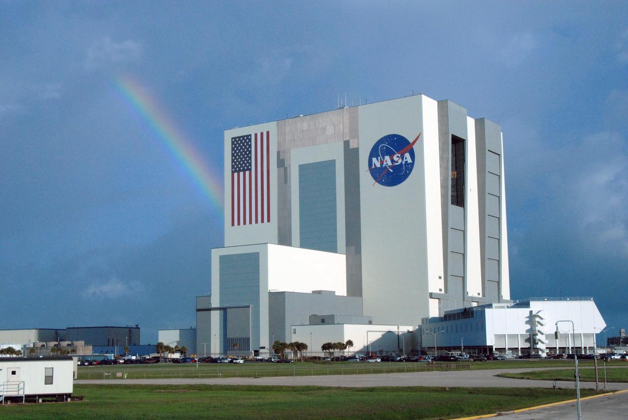
CAPE CANAVERAL, Fla. – Between rain showers over NASA's Kennedy Space Center in Florida, a rainbow breaks through the clouds behind the Vehicle Assembly Building. Rain and thunderstorms caused the waveoff of two landing opportunities Sept. 10 for space shuttle Discovery's return to Earth from the STS-128 mission. Photo credit: NASA/Jim Grossmann
The ALOFT mission, Airborne Lightning Observatory for Fly’s eye simulator and Terrestrial gamma ray flashes, is a collaboration between NASA and the University of Bergen, Norway. NASA Armstrong Flight Research Center’s ER-2 aircraft flies just above the height of thunderclouds over the Floridian and Caribbean coastlines to collect data about lightning glows and terrestrial gamma ray flashes. Scientists expect to collect more accurate data than ever before that can advance the study of high-energy radiation emissions from thunderstorms.
The ALOFT mission, Airborne Lightning Observatory for Fly’s eye simulator and Terrestrial gamma ray flashes, is a collaboration between NASA and the University of Bergen, Norway. NASA Armstrong Flight Research Center’s ER-2 aircraft flies just above the height of thunderclouds over the Floridian and Caribbean coastlines to collect data about lightning glows and terrestrial gamma ray flashes. Scientists expect to collect more accurate data than ever before that can advance the study of high-energy radiation emissions from thunderstorms.
At 11:29 p.m. PDT on Oct. 6 (2:29 a.m. EDT on Oct. 7), NASA's Atmospheric Infrared Sounder (AIRS) instrument on NASA's Aqua satellite produced this false-color infrared image of Matthew as the storm moved up Florida's central coast. The image shows the temperature of Matthew's cloud tops or the surface of Earth in cloud-free regions, with the most intense thunderstorms shown in purples and blues. http://photojournal.jpl.nasa.gov/catalog/PIA21097

Torsten Neubert of the National Space Institute at the Technical University of Denmark, and principal investigator for the Atmosphere-Space Interactions Monitor, discusses how this Earth observatory will study severe thunderstorms and their role in the Earth's atmosphere and climate. This is one of the scientific investigations that will be aboard a Dragon spacecraft scheduled for liftoff from Cape Canaveral Air Force Station's Space Launch Complex 40 at 4:30 p.m. EST, on April 2, 2018. The SpaceX Falcon 9 rocket will launch the company's 14th Commercial Resupply Services mission to the space station.
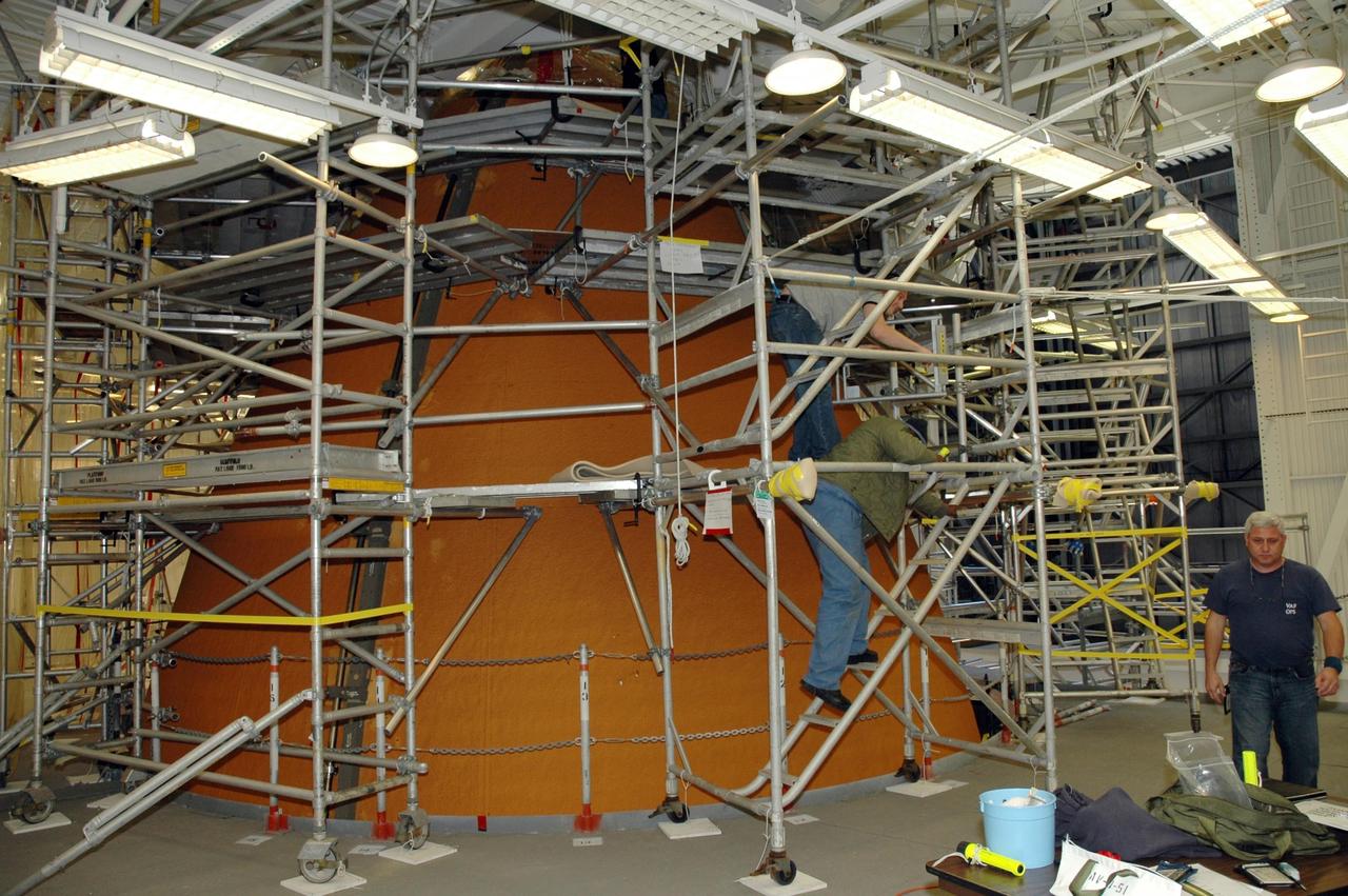
KENNEDY SPACE CENTER, FLA. -- In Highbay 1 inside the Vehicle Assembly Building, workers secure scaffolding around the external tank to prepare it for repairs. A severe thunderstorm with golf ball-sized hail caused visible divots in the giant tank's foam insulation and minor surface damage to about 26 heat shield tiles on the shuttle's left wing. A new target launch date has not been determined, but teams will focus on preparing Atlantis for liftoff in late April on mission STS-117. Photo credit: NASA/Jim Grossmann
The ALOFT mission, Airborne Lightning Observatory for Fly’s eye simulator and Terrestrial gamma ray flashes, is a collaboration between NASA and the University of Bergen, Norway. NASA Armstrong Flight Research Center’s ER-2 aircraft flies just above the height of thunderclouds over the Floridian and Caribbean coastlines to collect data about lightning glows and terrestrial gamma ray flashes. Scientists expect to collect more accurate data than ever before that can advance the study of high-energy radiation emissions from thunderstorms.
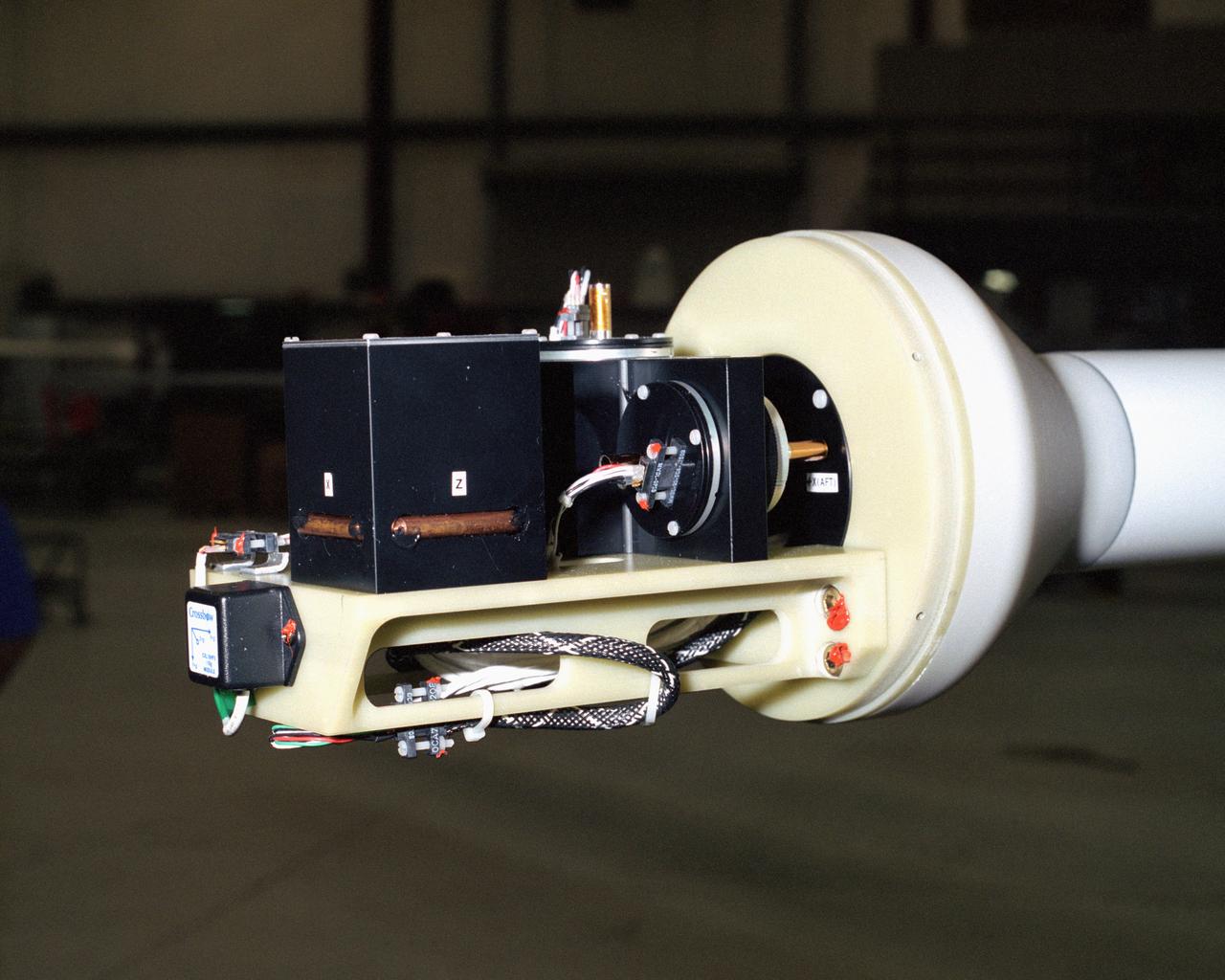
A NASA team studying the causes of electrical storms and their effects on our home planet achieved a milestone on August 21, 2002, completing the study's longest-duration research flight and monitoring four thunderstorms in succession. Based at the Naval Air Station Key West, Florida, researchers with the Altus Cumulus Electrification Study (ACES) used the Altus II remotely-piloted aircraft to study thunderstorms in the Atlantic Ocean off Key West and the west of the Everglades. Data obtained through sensors mounted to the aircraft will allow researchers in ACES to gauge elements such as lightning activity and the electrical environment in and around storms. By learning more about individual storms, scientists hope to better understand the global water and energy cycle, as well as climate variability. Contained in one portion of the aircraft is a three-axis magnetic search coil, which measures the AC magnetic field; a three-axis electric field change sensor; an accelerometer; and a three-axis magnetometer, which measures the DC magnetic field. With dual goals of gathering weather data safely and testing the adaptability of the uninhabited aircraft, the ACES study is a collaboration among the Marshall Space Flight Center, the University of Alabama in Huntsville, NASA's Goddard Space Flight Center in Greenbelt, Maryland, Pernsylvania State University in University Park, and General Atomics Aeronautical Systems, Inc.

STS111-E-5451 (17 June 2002) --- Sharp air mass boundaries, such as this one photographed by astronauts on board the Space Shuttle Endeavour on June 17, 2002, often are the focus of development for severe thunderstorms. According to meteorologists, this storm formed in the late afternoon over Eastern China. The sunlit anvil tops of thunderstorms here are estimated to be in excess of 60,000 feet (18,300 meters) where icy cirrus clouds form near the top of the troposphere. The distribution and impact of such high clouds are a significant challenge to scientists modeling the Earth’s energy budget and climate. The crew of the International Space Station is attempting to acquire such imagery over Florida this summer in support of a large, multi-agency experiment CRYSTAL - FACE (Cirrus Regional Study of Tropical Anvils and Cirrus Layers - Florida Area Cirrus Experiment). This experiment is designed to collect measurements of clouds that will help improve climate models. Such photos have the potential to provide profound, synoptic visuals for use in describing and interpreting these measurements. More information on CRYSTAL - FACE as well as other images of the atmosphere are available at http://cloud1.arc.nasa.gov/crystalface/.
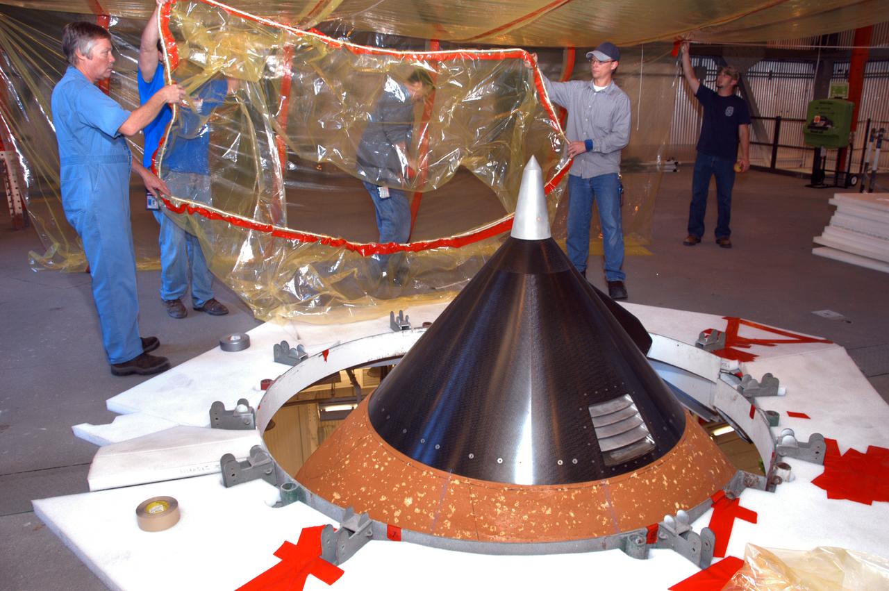
On an upper level of high bay 1 of the Vehicle Assembly Building, technicians move protective material toward the nose cone (foreground) of Atlantis' external tank. The nose cone will undergo repair for hail damage. A severe thunderstorm with golf ball-sized hail caused visible divots in the giant tank's foam insulation and minor surface damage to about 26 heat shield tiles on the shuttle's left wing. Further evaluation of the tank is necessary to get an accurate accounting of foam damage and determine the type of repair required and the time needed for that work. A new target launch date has not been determined, but teams will focus on preparing Atlantis for liftoff in late April on mission STS-117.
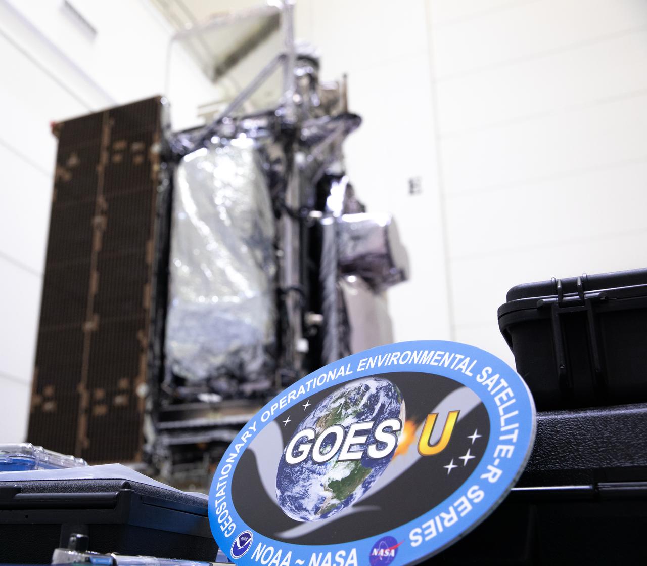
The mission insignia of NOAA’s Geostationary Operational Environmental Satellite-U (GOES-U) mission is pictured in front of the satellite in a vertical position on Wednesday, Jan. 24, 2024, at the Astrotech Space Operations Facility near the agency’s Kennedy Space Center in Florida. Part of a collaborative NOAA and NASA program, GOES-U is the fourth in a series of four advanced geostationary weather satellites. Data from the GOES satellite constellation – consisting of the GOES-R, GOES-S, GOES-T and GOES-U spacecraft – enables forecasters to predict, observe, and track local weather events that affect public safety like thunderstorms, hurricanes, and wildfires.
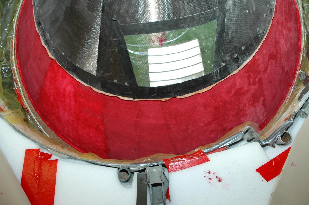
KENNEDY SPACE CENTER, FLA. -- In Highbay 1 inside the Vehicle Assembly Building, an area near the top of the external tank has been covered in a red dye to help expose cracks or compression dents. A severe thunderstorm with golf ball-sized hail caused visible divots in the giant tank's foam insulation and minor surface damage to about 26 heat shield tiles on the shuttle's left wing. A new target launch date has not been determined, but teams will focus on preparing Atlantis for liftoff in late April on mission STS-117. Photo credit: NASA/Jim Grossmann