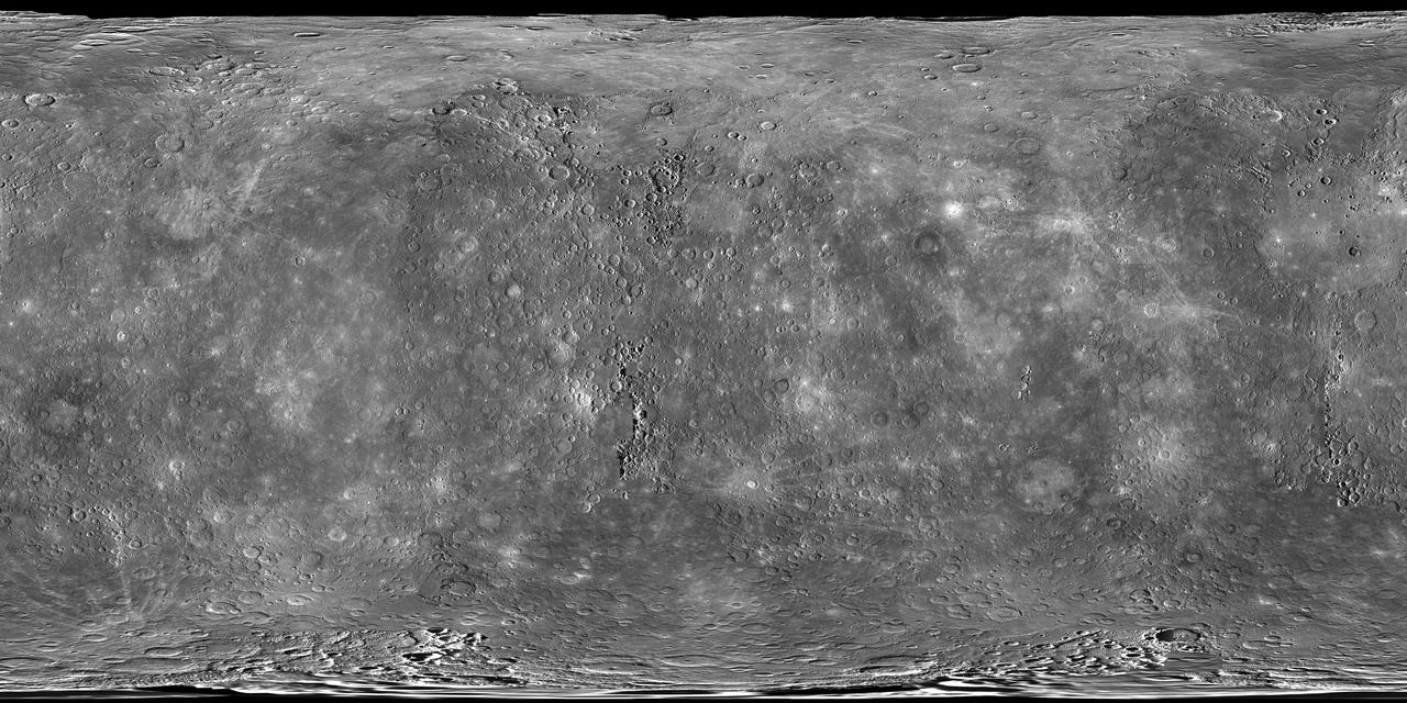
A World View
One View, Multiple Worlds
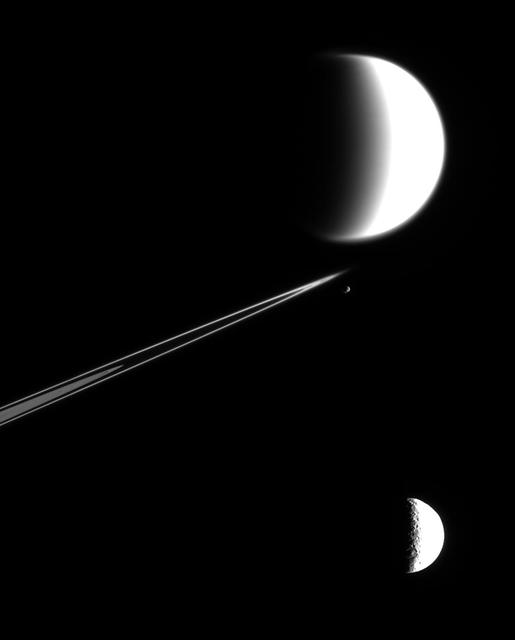
The water-world Enceladus appears here to sit atop Saturn rings like a drop of dew upon a leaf in this view from NASA Cassini spacecraft.
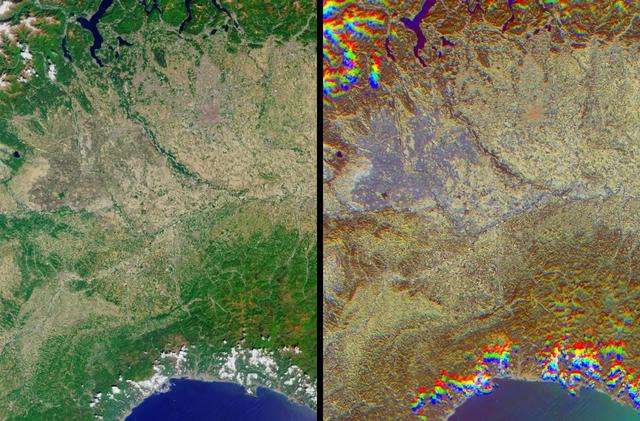
The lowlands of Lombardy and Piedmont in northwest Italy are some of the most highly developed irrigation areas in the world. These views of the region were acquired on May 8, 2005, by NASA Terra spacecraft.
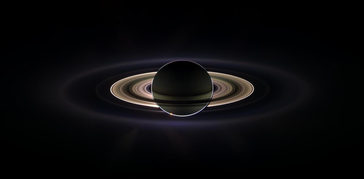
With giant Saturn hanging in the blackness and sheltering Cassini from the sun blinding glare, the spacecraft viewed the rings as never before, revealing previously unknown faint rings and even glimpsing its home world.
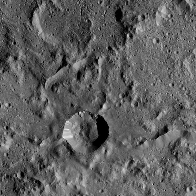
NASA Dawn spacecraft flys over dwarf planet Ceres which Dawn has been orbiting for mre than a year, providing us with fascinating views of an alien world.
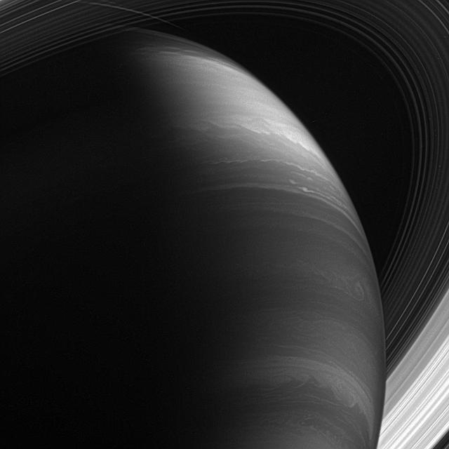
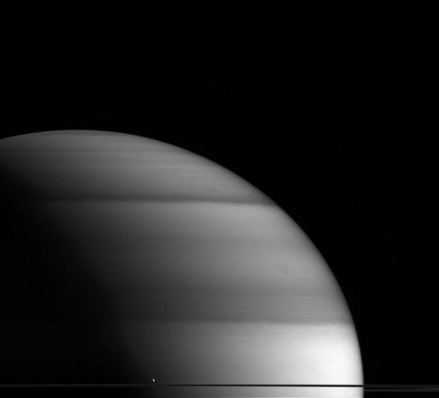
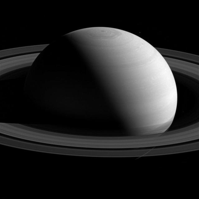
The giant planet is a moody world whose disposition appears to change with he view. Its atmosphere rages with thunderous and hurricane-like storms. Its majestic rings spin a tale of ancient collisions and cataclysm
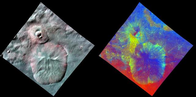
This image combines two separate views of the giant asteroid Vesta obtained by NASA Dawn spacecraft. The data reveal a world of many varied, well-separated layers and ingredients.
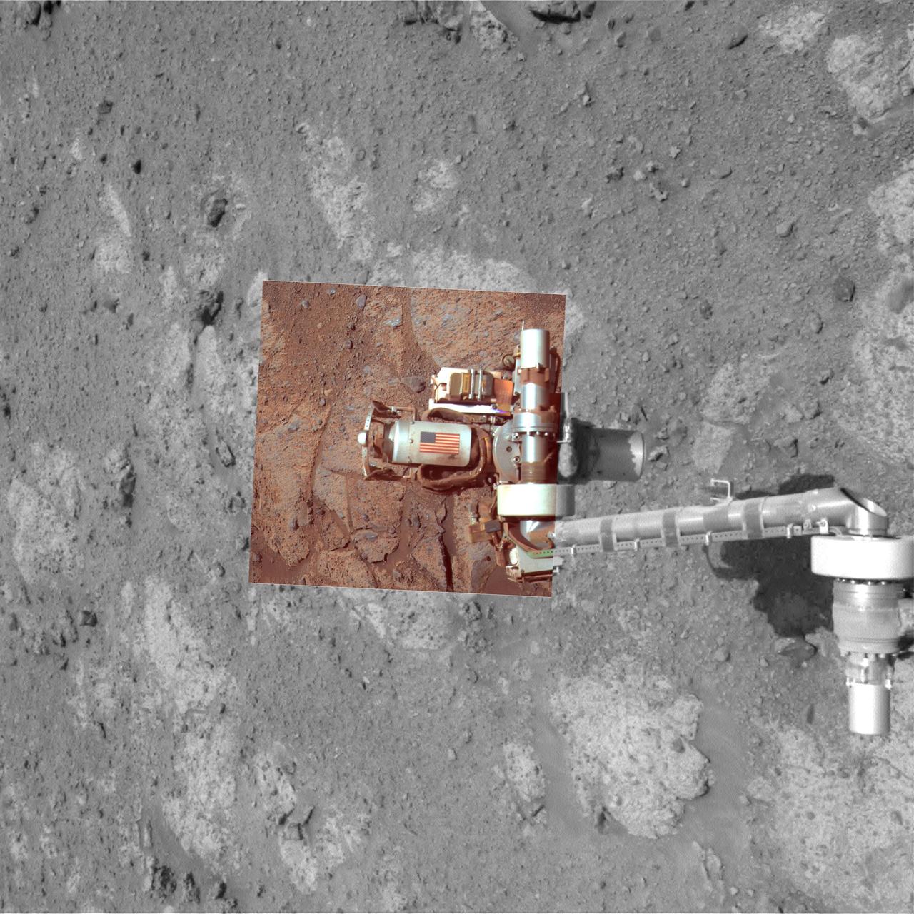
This view from NASA rover Opportunity, of an American flag on metal recovered from the site of the World Trade Center towers shortly after their destruction, was taken on Mars on Sept. 11, 2011, the 10th anniversary of the attacks on the towers.
NASA Dawn spacecraft flys over dwarf planet Ceres which Dawn has been orbiting for mre than a year, providing us with fascinating views of an alien world.

This artist animation shows a blistering world revolving around its nearby un. NASA infrared Spitzer Space Telescope observed a planetary system like this one, as the planet sunlit and dark hemispheres swung alternately into the telescope view.
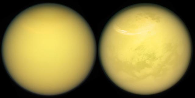
These two views of Saturn's moon Titan exemplify how NASA's Cassini spacecraft has revealed the surface of this fascinating world. Cassini carried several instruments to pierce the veil of hydrocarbon haze that enshrouds Titan. The mission's imaging cameras also have several spectral filters sensitive to specific wavelengths of infrared light that are able to make it through the haze to the surface and back into space. These "spectral windows" have enable the imaging cameras to map nearly the entire surface of Titan. In addition to Titan's surface, images from both the imaging cameras and VIMS have provided windows into the moon's ever-changing atmosphere, chronicling the appearance and movement of hazes and clouds over the years. A large, bright and feathery band of summer clouds can be seen arcing across high northern latitudes in the view at right. These views were obtained with the Cassini spacecraft narrow-angle camera on March 21, 2017. Images taken using red, green and blue spectral filters were combined to create the natural-color view at left. The false-color view at right was made by substituting an infrared image (centered at 938 nanometers) for the red color channel. The views were acquired at a distance of approximately 613,000 miles (986,000 kilometers) from Titan. Image scale is about 4 miles (6 kilometers) per pixel. https://photojournal.jpl.nasa.gov/catalog/PIA21624
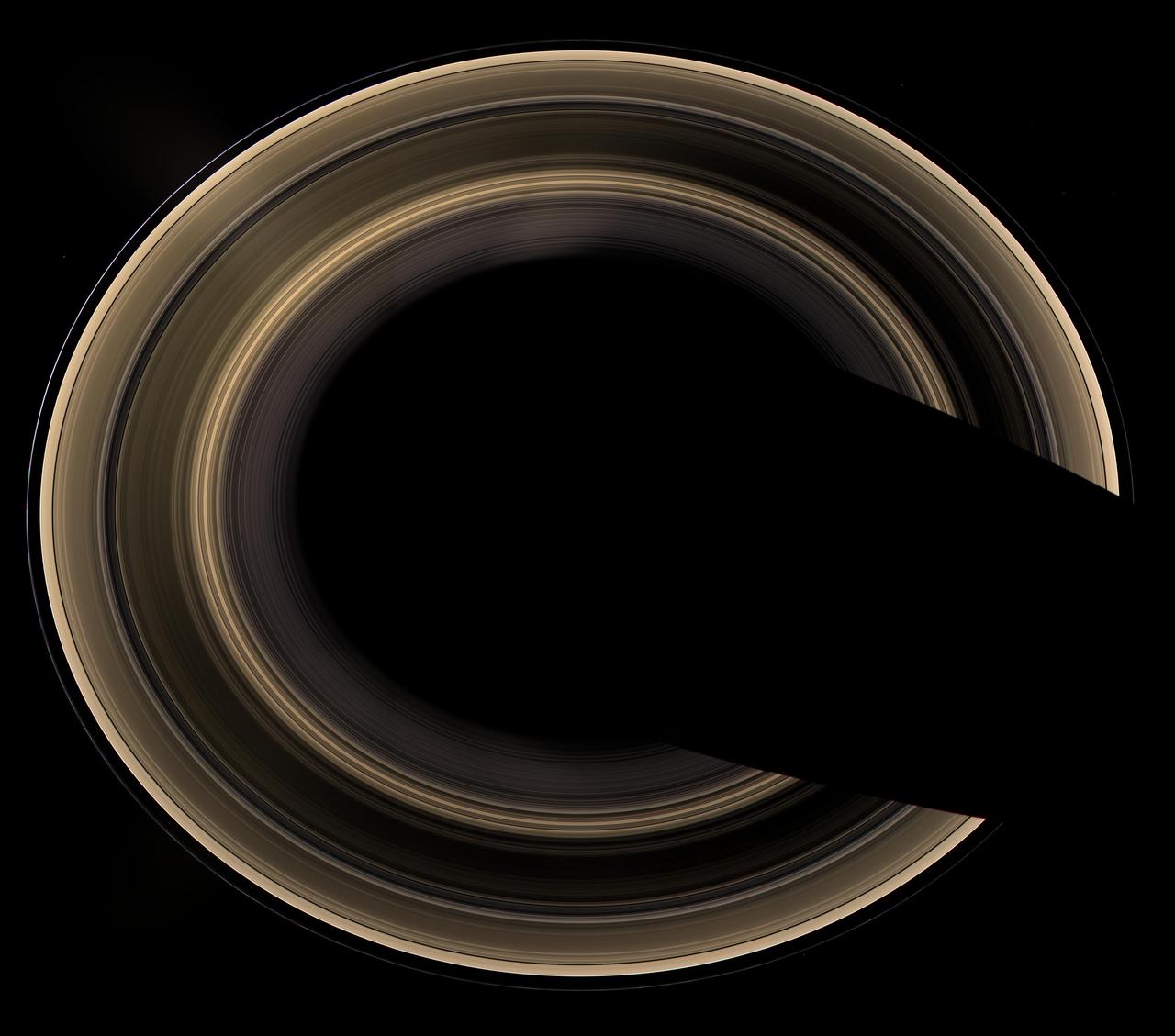
Our robotic emissary, flying high above Saturn, captured this view of an alien copper-colored ring world. The overexposed planet has deliberately been removed to show the unlit rings alone, seen from an elevation of 60 degrees

This close-up view of a plate on NASA's Perseverance rover commemorating the impact of the COVID-19 pandemic and paying tribute to the perseverance of health care workers around the world was acquired on June 28, 2025 (the 1,548th day, or sol, of its mission to Mars). Located on the left side of the rover chassis, the 3-by-5-inch (8-by-13-centimeter) aluminum plaque was attached in May 2020 during final assembly at NASA's Kennedy Space Center in Florida. https://photojournal.jpl.nasa.gov/catalog/PIA26641
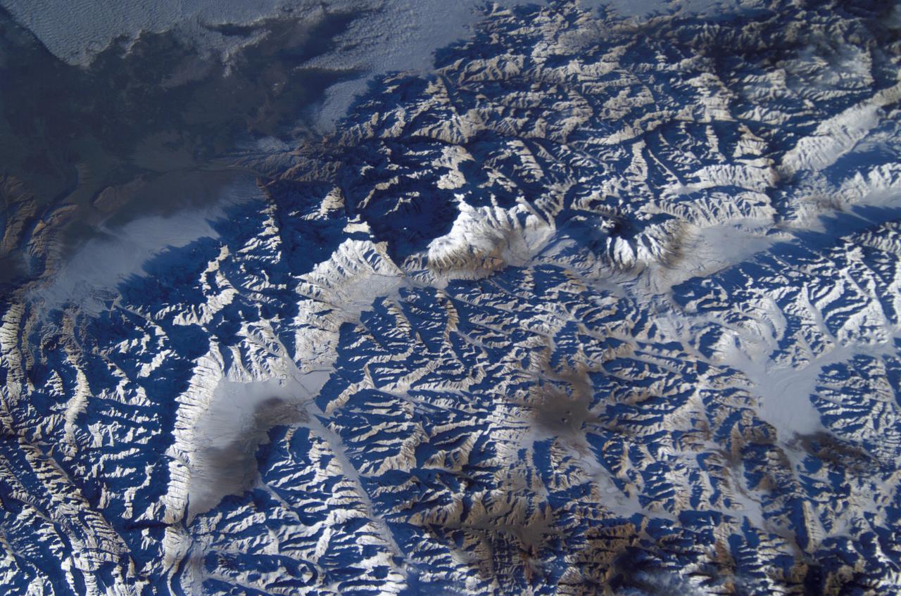
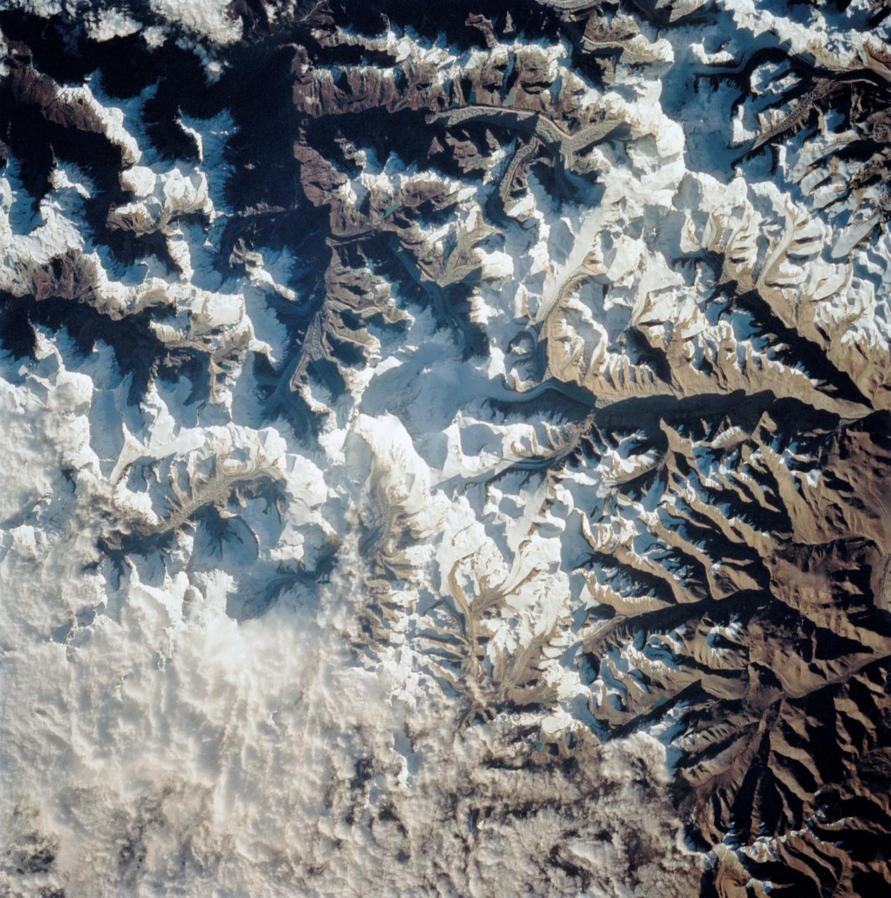
ISS008-E-08767 (12 December 2003) --- This view featuring K-2 Mountain in Pakistan, the world’s second highest peak, was photographed by an Expedition 8 crewmember on the International Space Station (ISS).
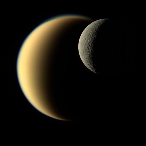
In this view, Saturn's icy moon Rhea passes in front of Titan as seen by NASA's Cassini spacecraft. Some of the differences between the two large moons are readily apparent. While Rhea is a heavily-cratered, airless world, Titan's nitrogen-rich atmosphere is even thicker than Earth's. This natural color image was taken in visible light with the Cassini narrow-angle camera on Nov. 19, 2009, at a distance of approximately 713,300 miles (1,148,000 kilometers) from Rhea. The Cassini spacecraft ended its mission on Sept. 15, 2017. https://photojournal.jpl.nasa.gov/catalog/PIA21904

In this fish-eye view, a worker oversees the movement of the Chandra X-ray Observatory into the payload bay of the orbiter Columbia. Chandra is the primary payload on mission STS-93, scheduled to launch no earlier than July 20 aboard Space Shuttle Columbia. The world's most powerful X-ray telescope, Chandra will allow scientists from around the world to see previously invisible black holes and high-temperature gas clouds, giving the observatory the potential to rewrite the books on the structure and evolution of our universe
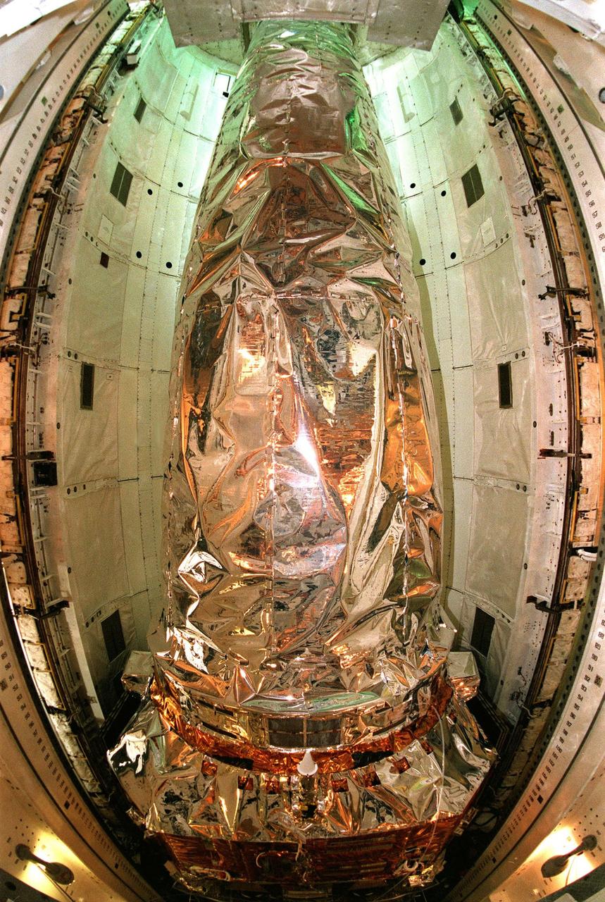
In this fish-eye view, the Chandra X-ray Observatory rests inside the payload bay of the orbiter Columbia. Chandra is the primary payload on mission STS-93, scheduled to launch no earlier than July 20 aboard Space Shuttle Columbia. The world's most powerful X-ray telescope, Chandra will allow scientists from around the world to see previously invisible black holes and high-temperature gas clouds, giving the observatory the potential to rewrite the books on the structure and evolution of our universe
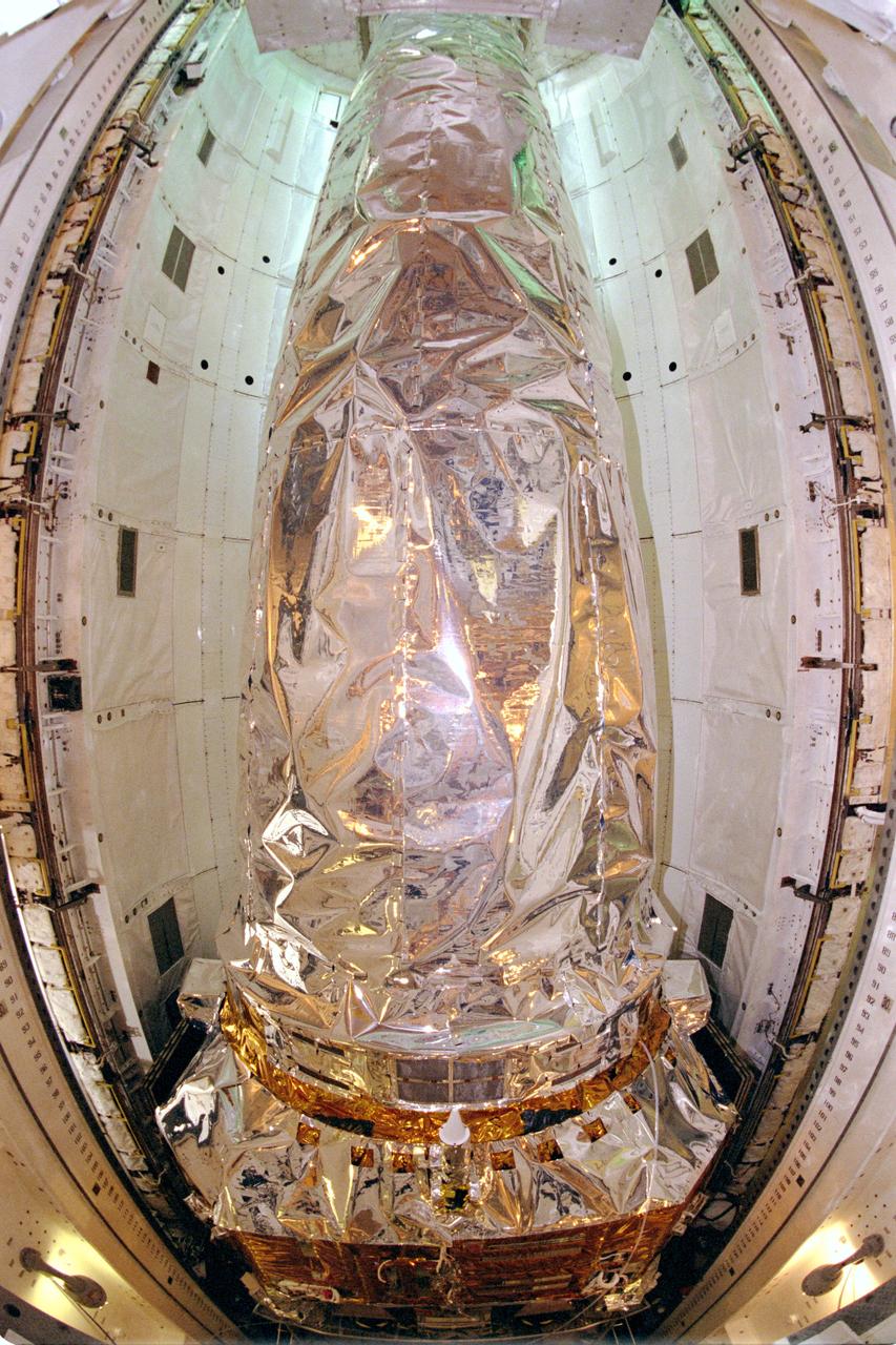
STS093-S-013 (27 June 1999) --- In this fish-eye view, the Chandra X-ray Observatory rests inside the payload bay of the Space Shuttle Columbia at the Kennedy Space Center (KSC). Chandra is the primary payload on the STS-93 mission, scheduled to launch next month. The world's most powerful X-ray telescope, Chandra, will allow scientists from around the world to see previously invisible black holes and high-temperature gas clouds, giving the observatory the potential to rewrite the books on the structure and evolution of the universe.
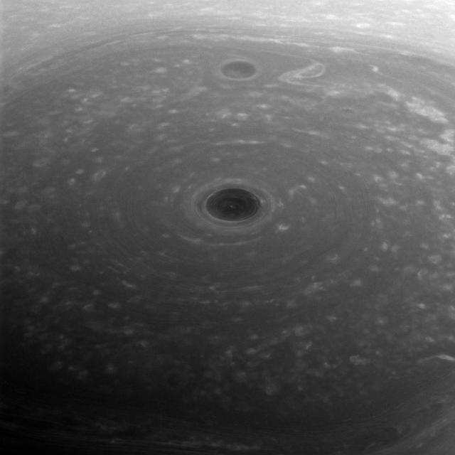
These turbulent clouds are on top of the world at Saturn. NASA's Cassini spacecraft captured this view of Saturn's north pole on April 26, 2017 - the day it began its Grand Finale -- as it approached the planet for its first daring dive through the gap between the planet and its rings. Although the pole is still bathed in sunlight at present, northern summer solstice on Saturn occurred on May 24, 2017, bringing the maximum solar illumination to the north polar region. Now the Sun begins its slow descent in the northern sky, which eventually will plunge the north pole into Earth-years of darkness. Cassini's long mission at Saturn enabled the spacecraft to see the Sun rise over the north, revealing that region in great detail for the first time. This view looks toward the sunlit side of the rings from about 44 degrees above the ring plane. The image was taken with the Cassini spacecraft wide-angle camera using a spectral filter which preferentially admits wavelengths of near-infrared light centered at 752 nanometers. The view was obtained at a distance of approximately 166,000 miles (267,000 kilometers) from Saturn. Image scale is about 10 miles (16 kilometers) per pixel. https://photojournal.jpl.nasa.gov/catalog/PIA21343
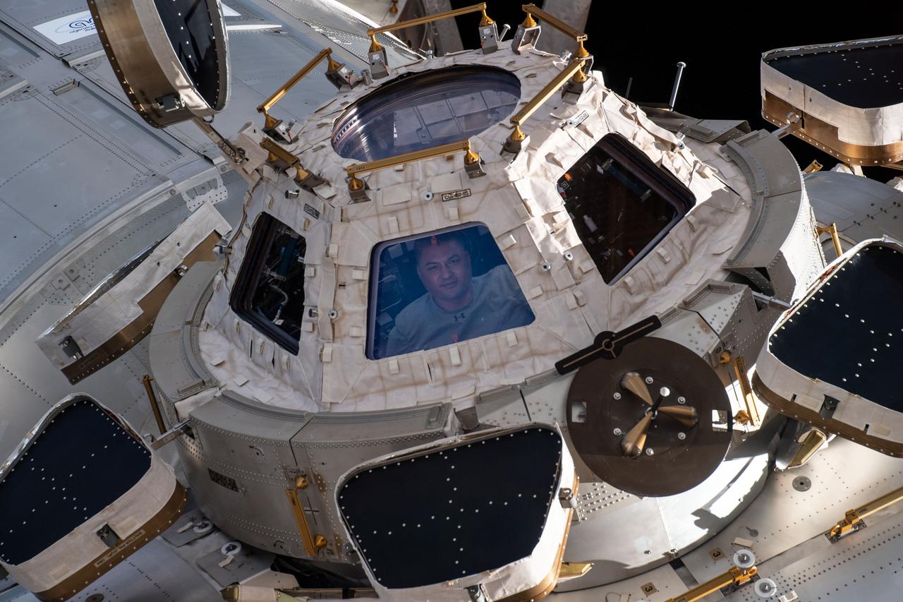
iss067e359897 (Sept. 12, 2022) --- NASA astronaut and Expedition 67 Flight Engineer Kjell Lindgren is pictured looking out from a window on the cupola, the International Space Station's "window to the world." The astronauts use the seven-windowed cupola to monitor the arrival of spaceships at the orbiting lab and view the Earth below.
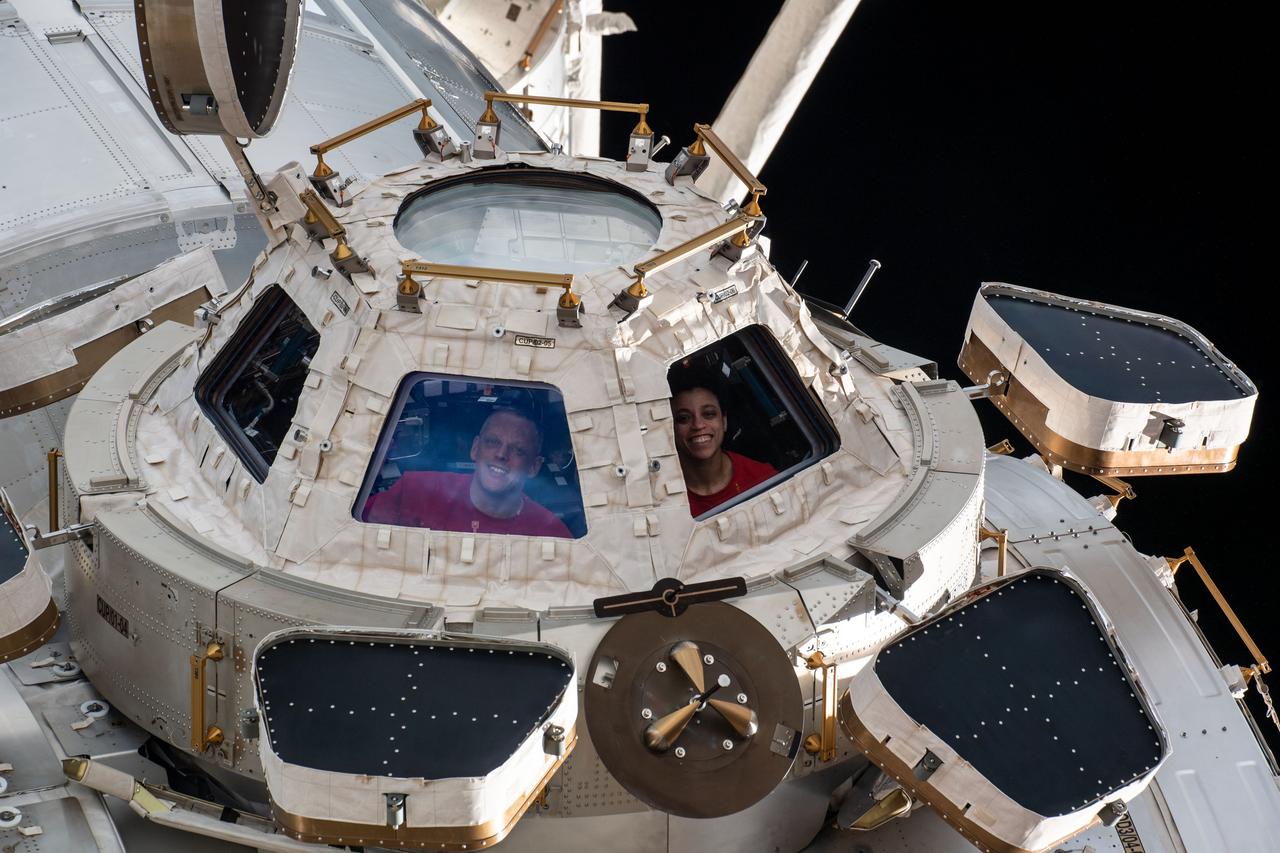
iss067e359846 (Sept. 12, 2022) --- Expedition 67 Flight Engineers Bob Hines and Jessica Watkins, both from NASA, are pictured looking out from a window on the cupola, the International Space Station's "window to the world." The astronauts use the seven-windowed cupola to monitor the arrival of spaceships at the orbiting lab and view the Earth below.
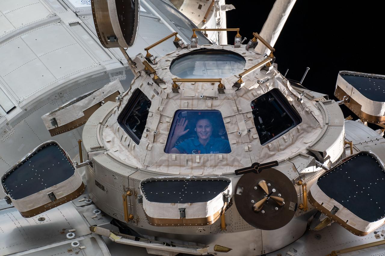
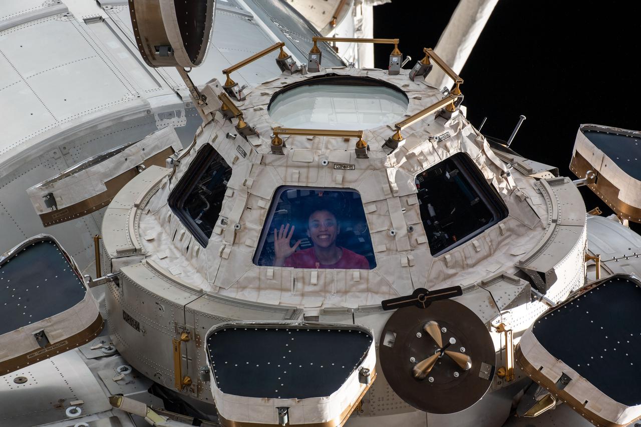
iss067e359828 (Sept. 12, 2022) --- ESA (European Space Agency) astronaut and Expedition 67 Flight Engineer Samantha Cristoforetti is pictured looking out from a window on the cupola, the International Space Station's "window to the world." The astronauts use the seven-windowed cupola to monitor the arrival of spaceships at the orbiting lab and view the Earth below.
iss067e359856 (Sept. 12, 2022) --- NASA astronaut and Expedition 67 Flight Engineer Jessica Watkins is pictured looking out from a window on the cupola, the International Space Station's "window to the world." The astronauts use the seven-windowed cupola to monitor the arrival of spaceships at the orbiting lab and view the Earth below.
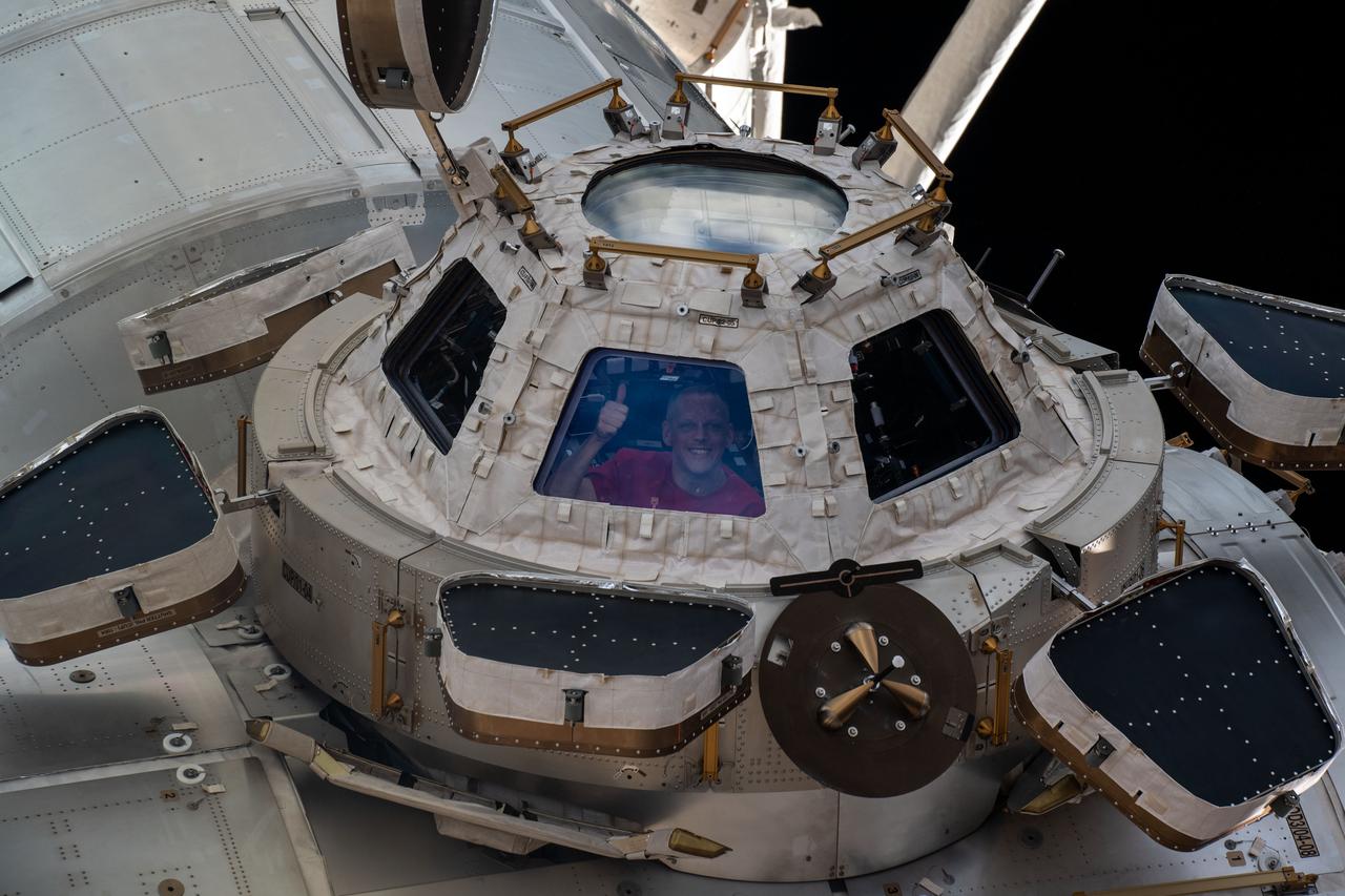
iss067e359812 (Sept. 12, 2022) --- NASA astronaut and Expedition 67 Flight Engineer Bob Hines is pictured looking out from a window on the cupola, the International Space Station's "window to the world." The astronauts use the seven-windowed cupola to monitor the arrival of spaceships at the orbiting lab and view the Earth below.

STS091-713-024 (2-12 June 1998) --- A 70mm view, taken from Discovery, showing heavy Smoke in Mexico along the coast of the Bay of Campeche. Fires across Mexico and Central America created heavy smoke plumes for a few weeks in May and June, 1998. The smoke circulated around a high pressure system over the Gulf of Mexico and brought thick smoke and soot to the south central United States. Scientists are looking at burning regions like this around the world to study the smokes affect on the albedo or the reflectance of the suns rays and how it may influence our world's climate. The fires in this view are north of the city of Villahermosa, in the lower center or south edge of the photo. The smaller city of Cardenas is to the west of Villahermosa. The point along the coast is the Rio Grijalva river delta. Laguna de Terminos is to the east of this delta.
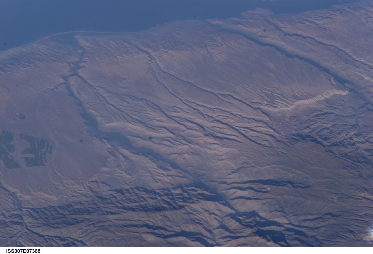
ISS007-E-07388 (14 June 2003) --- Some of the deepest canyons in the world cut west to the Pacific from the high crest of the Andes Mountains in Peru. This view taken by an Expedition 7 crewmember onboard the International Space Station (ISS) provides a birds-eye view down the canyons of the Rio Camana (center left) and the Rio Ocona (upper right). The low early morning sun highlights the extreme topography created by rapidly uplifting mountains and powerful water erosion by water dropping nearly 10,000 feet in this view. At the edge of the image are the snowy flanks of Nevado Coropuna, the highest mountain in the Cordillera Occidental (6613 meters). The coastal city of Camana is visible in the upper left.
Viewed from above in the Vertical Processing Facility, the Chandra X-ray Observatory is seen with one of its solar panel arrays attached, at right. Formerly called the Advanced X-ray Astrophysics Facility, Chandra comprises three major elements: the spacecraft, the science instrument module (SIM), and the world's most powerful X-ray telescope. Chandra will allow scientists from around the world to see previously invisible black holes and high-temperature gas clouds, giving the observatory the potential to rewrite the books on the structure and evolution of our universe. Chandra is scheduled for launch July 9 aboard Space Shuttle Columbia, on mission STS-93
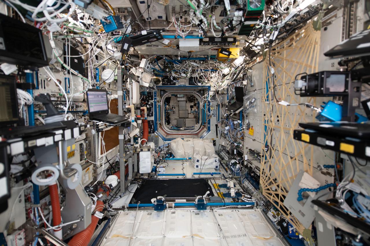
iss058e004610 (1/20/2019) --- A View of the Destiny US Laboratory aboard the International Space Station (ISS). The U.S. Laboratory Module, called Destiny, is the primary research laboratory for U.S. payloads, supporting a wide range of experiments and studies contributing to health, safety, and quality of life for people all over the world. Science conducted on the ISS offers researchers an unparalleled opportunity to test physical processes in the absence of gravity. The results of these experiments will allow scientists to better understand our world and ourselves and prepare us for future missions. Destiny provides internal interfaces to accommodate 24 equipment racks for accommodation and control of ISS systems and scientific research.
Front View of McDonald XP-85 Plan Model. Parasite Airplane designed to be carried in the B-36 bombay (never built) At the time it was the smallest Jet powered airplane. The McDonnell XF-85 Goblin was an American prototype fighter aircraft conceived during World War II by McDonnell Aircraft. It was intended to be deployed from the bomb bay of the giant Convair B-36 bomber as a parasite fighter. The XF-85's intended role was to defend bombers from hostile interceptor aircraft, a need demonstrated during World War II
STS091-701-075 (2-12 June 1998) --- Fires across Mexico and Central America which created heavy smoke plumes for a few weeks in May and June, 1998, were recorded on 70mm film by the crewmembers of STS-91. The smoke circulated around a high pressure system over the Gulf of Mexico and brought thick smoke and soot to the south central United States. Scientists are looking at burning regions like this around the world to study the smokes affect on the albedo or the reflectance of the sun's rays and how it may influence the world's climate. This view captures the area from the Gulf of Tehuantepec, on the south side, to the Bay of Campeche to the north in early June 1998.
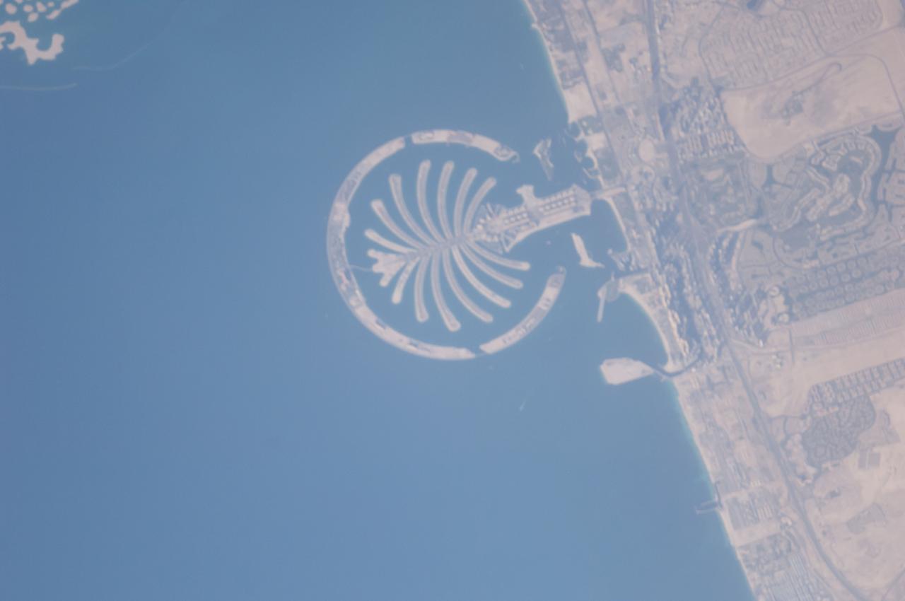
ISS040-E-125332 (4 Sept. 2014) --- Palm Jumeirah, protruding off the Persian Gulf Coast of Dubai in the United Arab Emirates, is featured in this 800mm photograph, taken by one of the Expedition 40 crew members aboard the International Space Station. The municipality of Dubai is the largest city of the Persian Gulf emirate of the same name, and has built a global reputation for large-scale developments and architectural works. Among the most visible of these developments ? particularly from the perspective of crew members onboard the space station ? are three man-made archipelagos. The two Palm Islands (Palm Jumeirah and Palm Jebel Ali, which is not in this frame) appear as stylized palm trees when viewed from above. The World Islands evoke a rough map of the world from an air- or space-borne perspective. A very small part of the World Islands is seen in upper left corner.
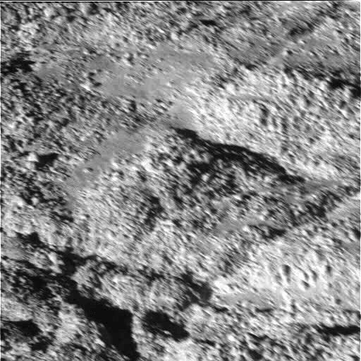
The tortured southern polar terrain of Enceladus appears strewn with great boulders of ice in this fantastic view, one of the highest resolution images obtained so far by Cassini of any world. Some smearing of the image due to spacecraft motion is apparent in this scene, which was acquired as Enceladus raced past Cassini's field of view near the time of closest approach. At the time, the imaging cameras were pointed close to the moon's limb (edge), rather than directly below the spacecraft. This allowed for less motion blur than would have been apparent had the cameras pointed straight down. Thus, the terrain imaged here was actually at a distance of 319 kilometers (198 miles) from Cassini. At this fine scale, the surface is dominated by ice blocks between 10 and 100 meters (33 and 330 feet) across. The origin of these icy boulders is enigmatic. Scientists are interested in studying the sizes and numbers of the blocks in this bizarre scene, and in understanding whether terrain covered with boulders is common on Enceladus. A wide-angle camera view centered on this location on Enceladus is available (see PIA06251), as well as a comparison view showing the position of this image within the wide-angle image (see PIA06250). The image was taken during Cassini's very close flyby of Enceladus on July 14, 2005, from a distance of approximately 208 kilometers (129 miles) above Enceladus. Resolution in the image is about 4 meters (13 feet) per pixel. The image has been contrast enhanced to improve the visibility of surface. http://photojournal.jpl.nasa.gov/catalog/PIA06252
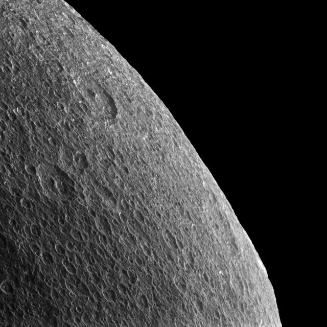
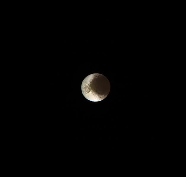
Gazing off toward the horizon is thought-provoking no matter what body's horizon it is. Rhea's horizon is slightly irregular and battered by craters, so thoughts inevitably turn towards the forces that shape these icy worlds. The surface of Rhea (949 miles or 1527 kilometers across) has been sculpted largely by impact cratering, each crater a reminder of a collision sometime in the moon's history. On more geologically active worlds like Earth, the craters would be erased by erosion, volcanoes or tectonics. But on quieter worlds like Rhea, the craters remain until they are disrupted or covered up by the ejecta of a subsequent impact. Lit terrain seen here is on the trailing hemisphere of Rhea. North on Rhea is up and rotated 12 degrees to the right. In this view, Cassini was at a subspacecraft latitude of 9 degrees North. The image was taken in visible light with the Cassini spacecraft narrow-angle camera on Feb. 10, 2015. The view was obtained at a distance of approximately 35,000 miles (56,000 kilometers) from Rhea and at a Sun-Rhea-spacecraft, or phase, angle of 76 degrees. Image scale is 1,100 feet (330 meters) per pixel. .http://photojournal.jpl.nasa.gov/catalog/pia18316
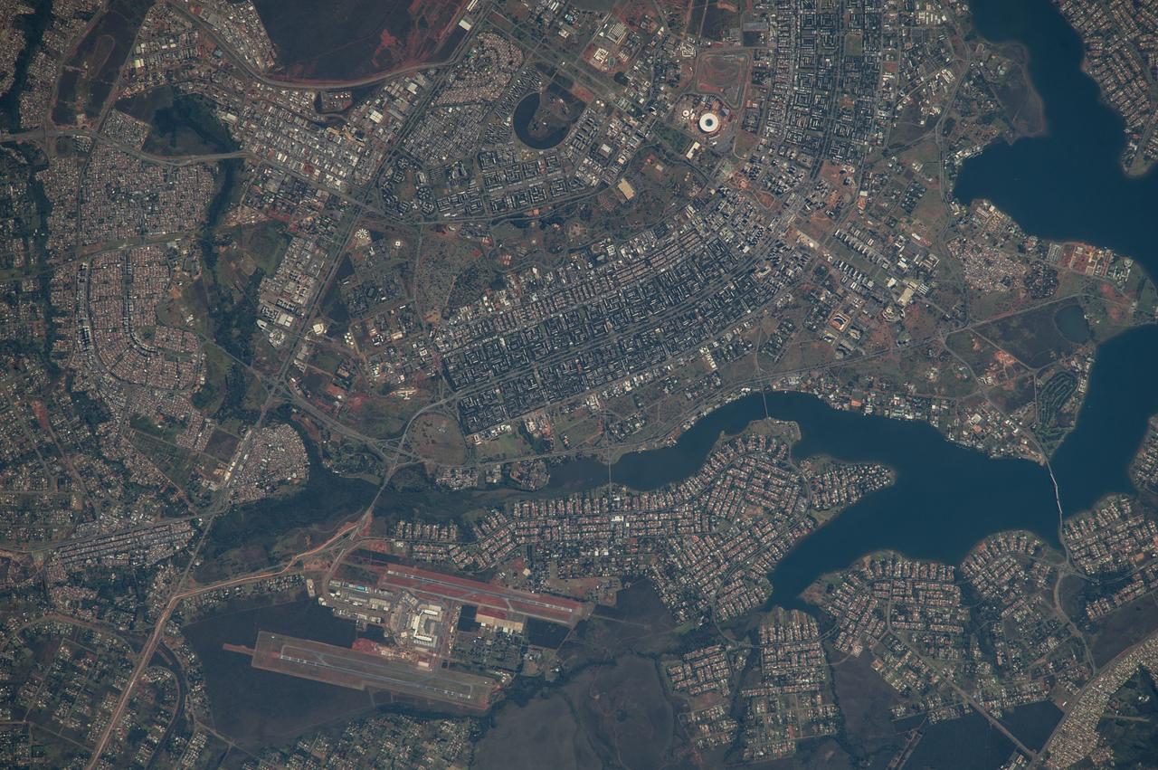
ISS040-E-005839 (28 May 2014) --- The Brasilia World Cup Stadium (top center) is featured in this image photographed by an Expedition 40 crew member on the International Space Station on May 28, 2014. Brazil?s national football stadium, the Estado Nacional, lies near the heart of the capital city of Brasilia. The new roof appears as a brilliant white ring in this image. The stadium is one of Brasilia?s largest buildings. Renovation began in 2010 and it is now the second most expensive stadium in the world, after Wembley Stadium in London, UK. To accommodate expected World Cup fans from all over the world, renovations for all modes of transportation, particularly airports, have been put in place in Brasilia and other host cities. Brasilia?s international airport can be seen lower left on the far side of Lake Paranoa. Brasilia is widely known for its modern building designs and city layout. Space station crew members have the best view of the city?s well-known ?swept wing? city layout ? giving the sense of a flying bird ? expressed in the curves of the boulevards (top). The stadium occupies the city center between the wings. The President Juscelino Kubitschek Bridge crosses the lake at bottom right. Its 1200-meter span gives scale to the city and stadium.
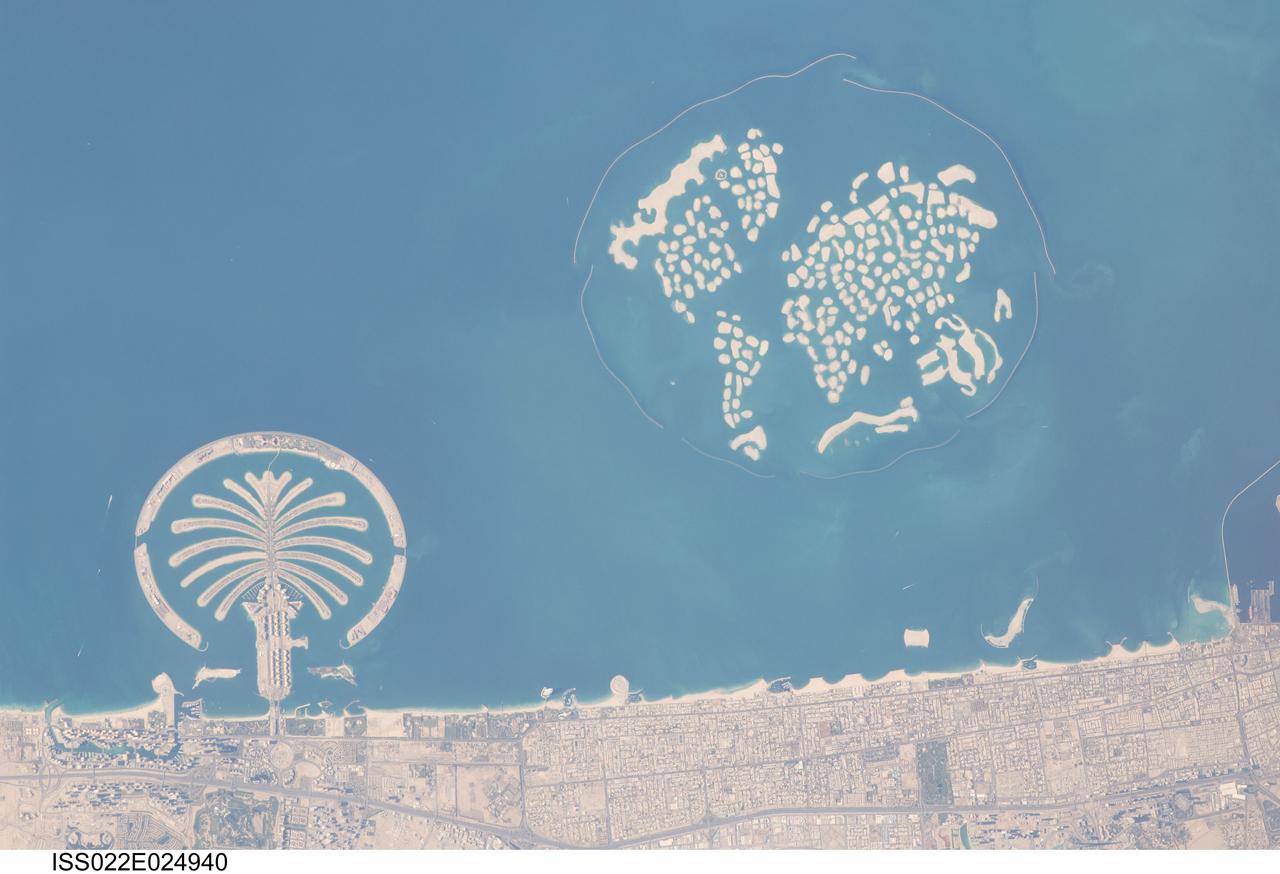
ISS022-E-024940 (13 Jan. 2010) --- Man-made archipelagos near Dubai, United Arab Emirates are featured in this image photographed by an Expedition 22 crew member on the International Space Station. The municipality of Dubai is the largest city of the Persian Gulf emirate of the same name, and has built a global reputation for large-scale developments and architectural works. Among the most visible of these developments ? particularly from the perspective of astronauts onboard the ISS ? are three man-made archipelagos. The two Palm Islands (Palm Jumeirah and Palm Jebel Ali) appear as stylized palm trees when viewed from above. The World Islands evoke a rough map of the world from an air- or space-borne perspective. Palm Jumeirah and the World Islands are highlighted in this view. Palm Jumeirah (lower left) was begun in 2001 and required more than 50 million cubic meters of dredged sand to raise the islands above the Persian Gulf sea level. Construction of the Palm Jumeirah islands was completed in 2006; they are now being developed for residential and commercial housing and infrastructure. Creation of the 300 World Islands (upper right) was begun in 2003 and completed in 2008, using 320 million cubic meters of sand and 37 million tons of rock for the surrounding 27 kilometer-long protective breakwater. Also visible at the lower edge of the image is another notable built structure ? the Burj Tower (white rectangle at lower right and inset image). The Burj Tower ? or Burj Khalifa ? stands 800 meters high, and is currently the world?s tallest structure. The photograph captures enough detail to make out the tapering outline of the building as well as its dark needle-like shadow pointing towards the northeast.
The entire Hawaiian Island Archipelago (21.5N, 158.0W) is seen in this single view. The islands are a favorite international resort and tourist attraction drawing visitors from all over the world to enjoy the tropical climate, year round beaches and lush island flora. Being volcanic in origin, the islands' offer a rugged landscape and on the big island of Hawaii, there is still an occasional volcanic eruption of lava flows and steam vents.
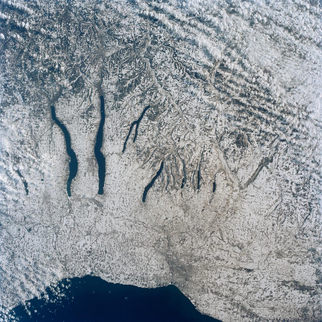
This view of the central portion of upstate New York, centers on the Finger Lakes. The large city on the shore of Lake Ontario, is Rochester. Although the city, being a business, educational and technical center, has no heavy industry, the outline of the city shows fairly well in the snow, but not as well as the outlines of industrial cities elsewhere in the world. The Finger Lakes are large linear lakes carved out by glaciers during the last ice age.
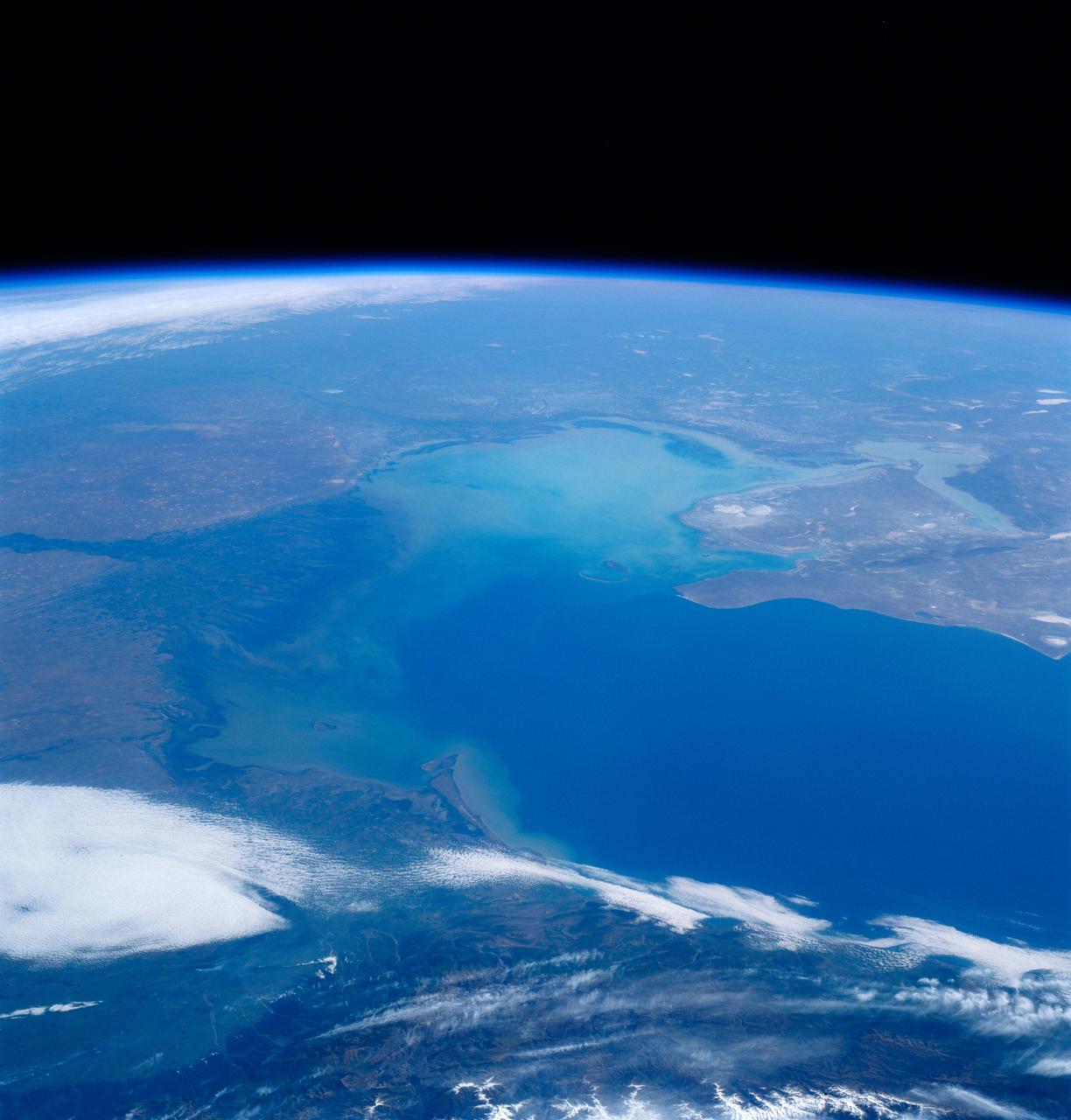
STS084-701-026 (15-24 May 1997) --- The Volga River enters the Caspian, the world's largest inland sea, from the north in this high oblique view. The Volga, the principle waterway of western Russian, is considered the historic cradle of Russia. The Ural River, east of the Volga, also enters the northern part of the Caspian. The dimensions of the Caspian are 1,200 kilometers (750 miles) from north to south, but averages 320 kilometers (200 miles) in width. Oil and natural gas are this regions most important resources.
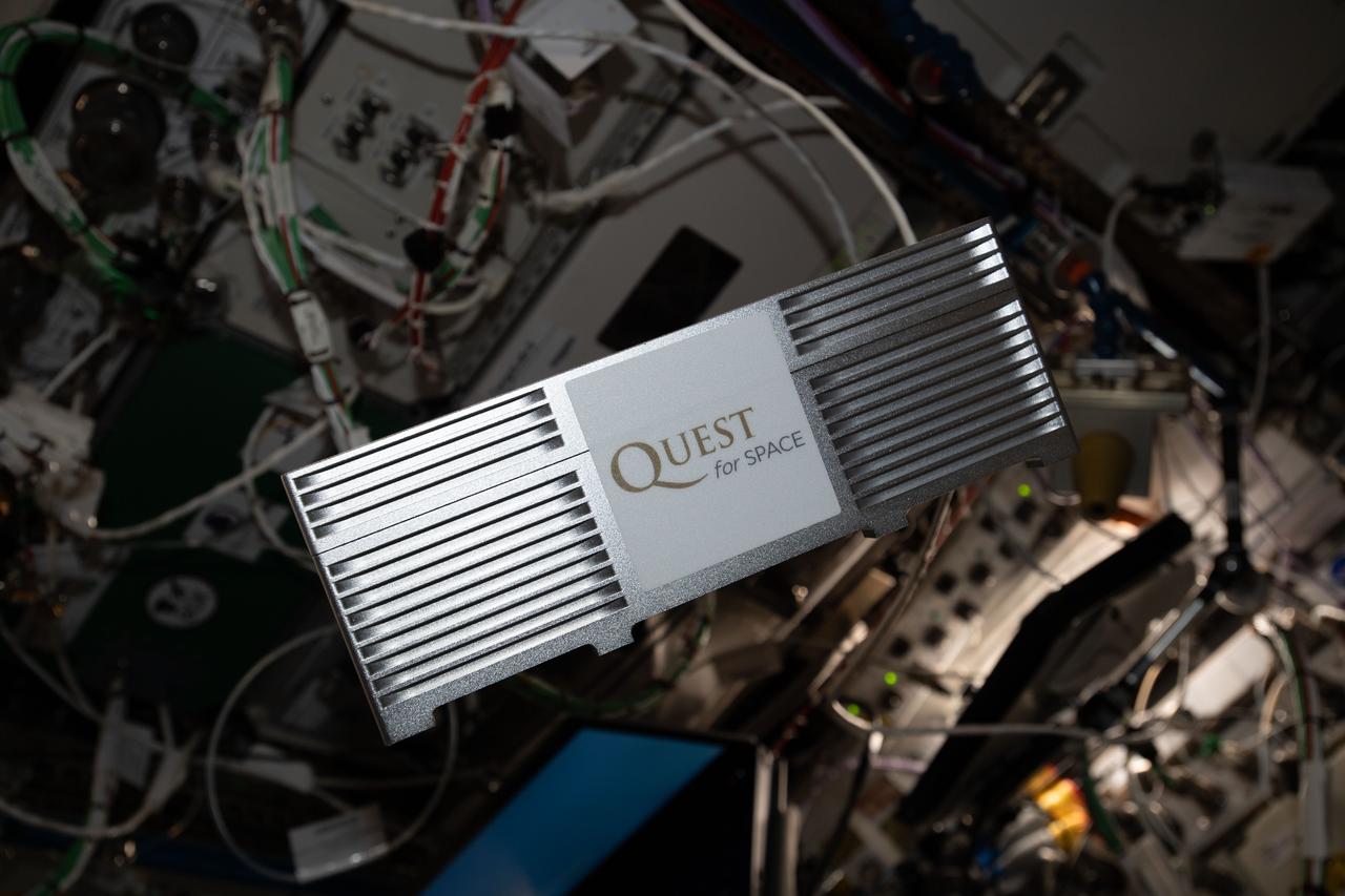
iss062e034557 (2/19/2020) --- A view of the Quest Institute-NanoLab Unit 3 investigation aboard the International Space Station (ISS). Quest Institute-NanoLab Unit 3 contains 15 Nano-Lab experiments from students in the United States and Singapore. Student-developed spaceflight experiments empower students with real-world science experience.
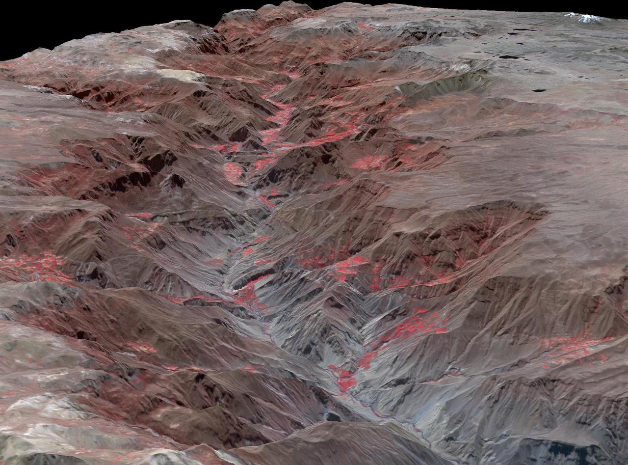
Cotahuasi Canyon, near the city of Arequipa, Peru, is one of the deepest canyons in the world. It reaches a maximum depth of 3,350 m, twice as deep as the Grand Canyon. Volcanic peaks nearby reach altitudes of over 6,000 meters. The perspective view is draped over an ASTER DEM, and projected with no vertical exaggeration. The image was acquired August 30, 2019, and is located at 15.3 degrees south, 73 degrees west. https://photojournal.jpl.nasa.gov/catalog/PIA24943
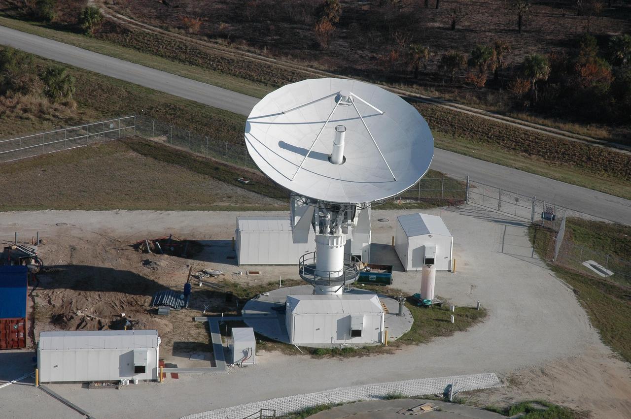
KENNEDY SPACE CENTER, FLA. - This view shows the new C-band, 3 megawatt radar with a 50-foot dish antenna recently installed on north Kennedy Space Center. It is one of the largest of its kind in the world, providing higher definition imagery than has ever been available before. Photo credit: Cory Huston
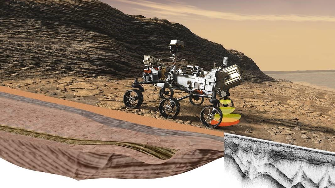
Perseverance's Radar Imager for Mars' Subsurface Experiment (RIMFAX) uses radar waves to probe the ground, revealing the unexplored world that lies beneath the Martian surface. The first ground-penetrating radar set on the surface of Mars, RIMFAX can provide a highly detailed view of subsurface structures down to at least 30 feet (10 meters) underground. In doing so, the instrument will reveal hidden layers of geology and help find clues to past environments on Mars, especially those with conditions necessary for supporting life. https://photojournal.jpl.nasa.gov/catalog/PIA24047
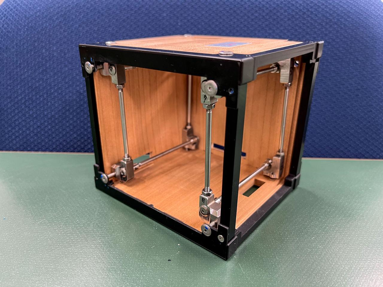
jsc2024e081749 (3/18/2023) --- LignoSat structural internal view shows the relationship among wooden panels, aluminum frames, and stainless steel shafts. LignoSat is the world’s first wooden satellite and investigates how wood changes in the space environment, as well as how wood transmits data through geomagnetic fields and wood’s resistance to cosmic radiation. Image courtesy of Kyoto University.

Ariana Lyons from Escatawpa Elementary School in Moss Point, Miss., experiences what it feels like to view the world out of a spacesuit during a visit to INFINITY Science Center, a NASA visitors center, Dec. 7. Lyons joined other young visitors to the facility that day in celebrating the 40th anniversary of the Apollo 17 mission to the moon in 1972.
The southern half of the island of Okinawa, Japan (26.5N, 128.0E) can be seen in this nearly cloud free view. Okinawa is part of the Ryuku Islands which extend from Taiwan northeastward to Kyushu, southernmost of the Japanese Home Islands. The large military base at Kadena, with large runways, is visible near the center of the scene. Kadena is one of several emergency landing sites around the world for the space shuttle.
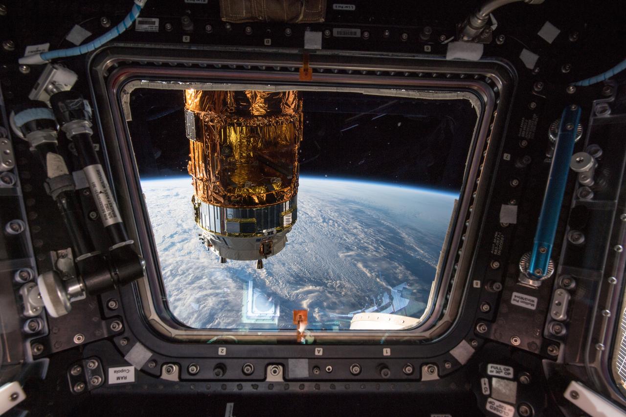
iss057e029243 (Oct. 11, 2018) --- The H-II Transfer Vehicle-7 (HTV-7) from the Japan Aerospace Exploration Agency (JAXA) is viewed from one of seven windows inside the cupola, the International Space Station's "window to the world." The orbital complex was flying at an altitude of about 257 miles off the coast of Canada above the Gulf of St. Lawrence.
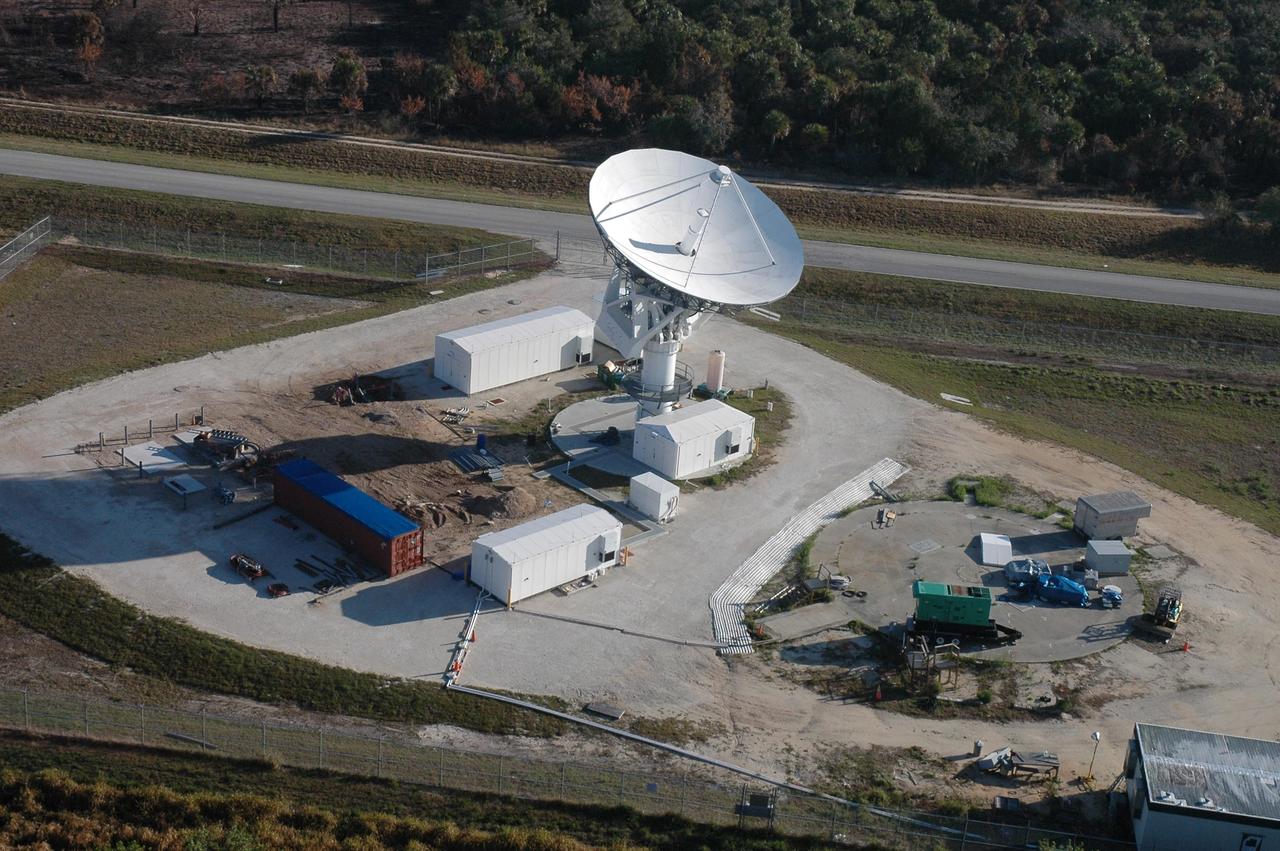
KENNEDY SPACE CENTER, FLA. - This view shows the new C-band, 3 megawatt radar with a 50-foot dish antenna recently installed on north Kennedy Space Center. It is one of the largest and most powerful of its kind in the world, providing higher definition launch imagery than has ever been available before. Photo credit: Cory Huston
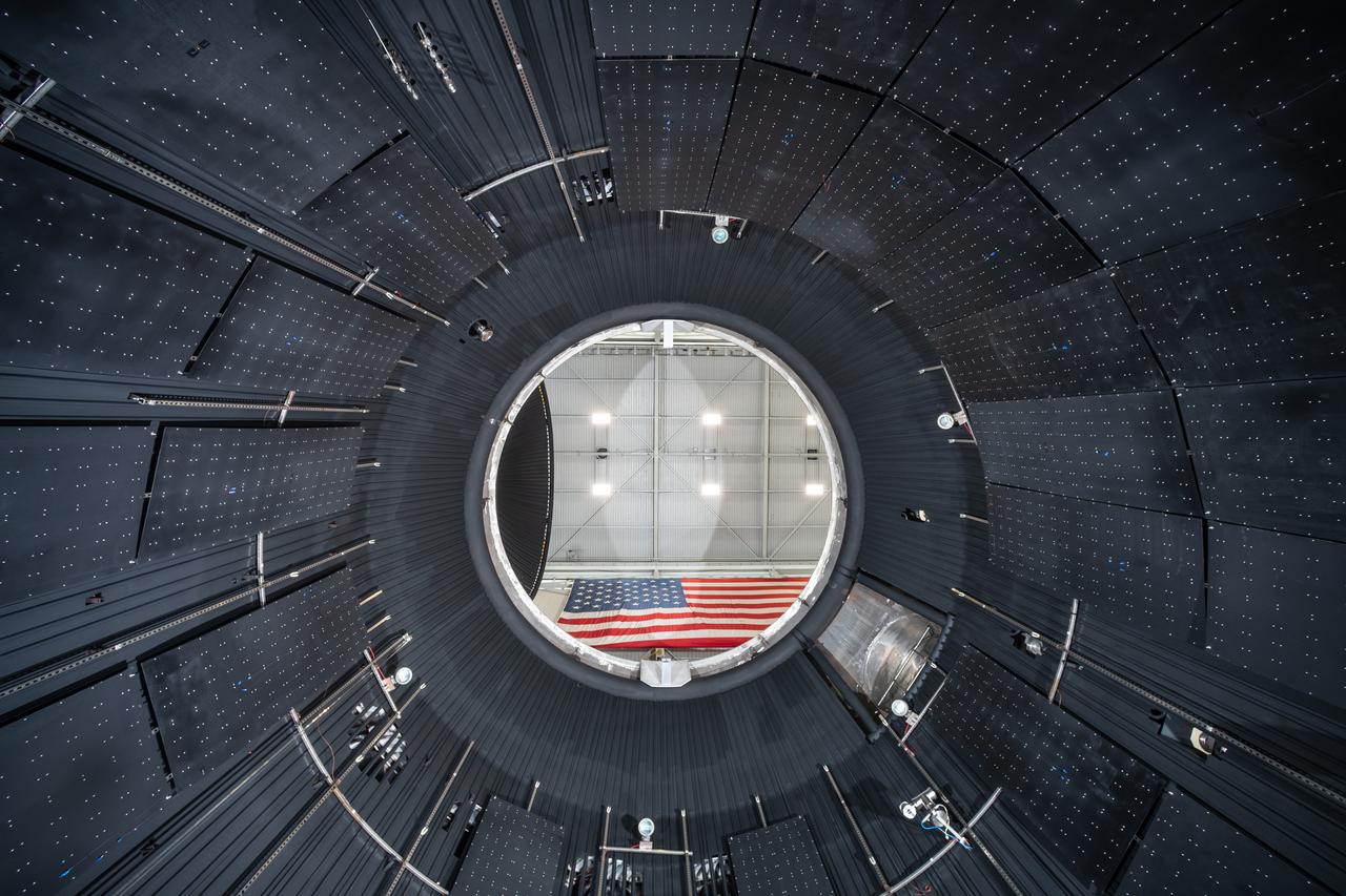
The vacuum chamber of the In-Space Propulsion (ISP) facility at the Neil Armstrong Test Facility spans 38ft in diameter and is 62ft tall. ISP is the world’s only facility capable of full-scale rocket engine and launch vehicle system level tests. ISP also has a vacuum range of up to 100 statute miles in altitude. This is a view from inside the chamber. Photo Credit: (NASA/Jordan Salkin)
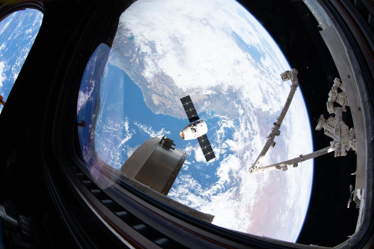
iss061e070168 (Dec. 8, 2019) --- This view from the cupola, the International Space Station's "window to the world," shows the SpaceX Dragon resupply ship slowly approaching the orbiting lab as both spacecraft were orbiting 258 miles above the Mediterranean Sea. The Canadarm2 robotic arm (at right) is poised to reach out and grapple Dragon and install the U.S. space freighter to the Harmony module.
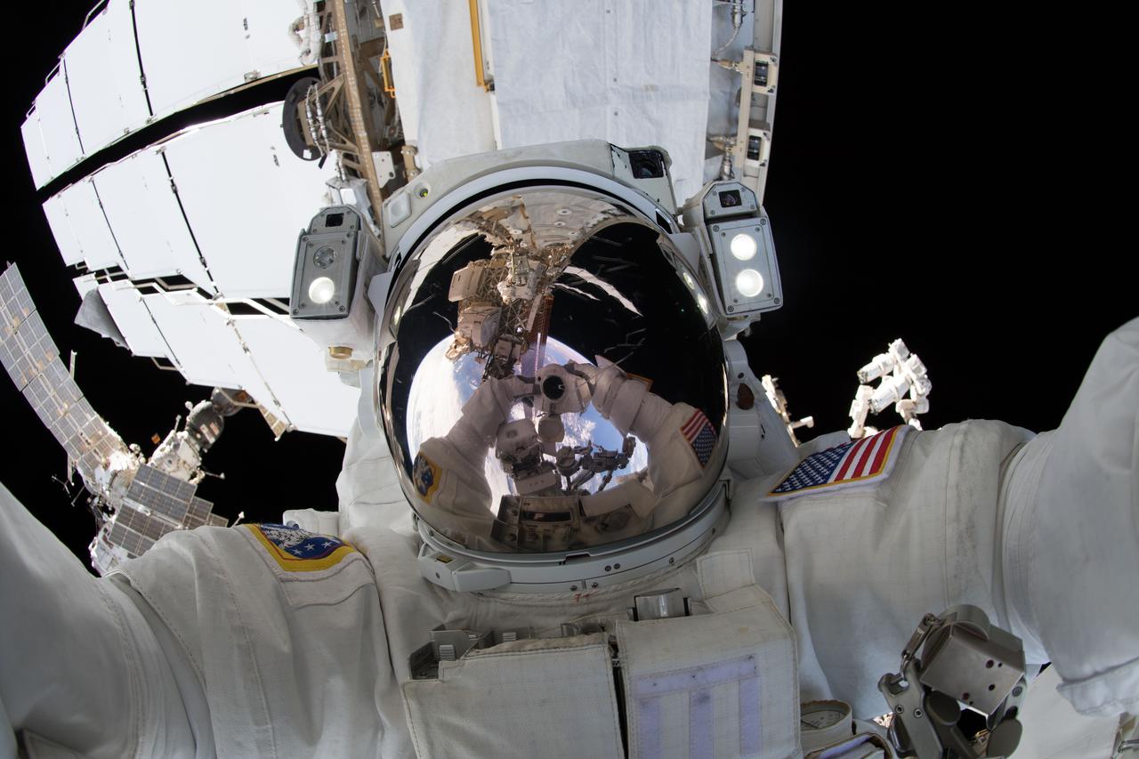
iss056e012043 (June 14, 2018) --- NASA astronaut Ricky Arnold takes an out-of-this-world "space-selfie" during a spacewalk he conducted with fellow NASA astronaut Drew Feustel (out of frame) on June 14, 2018. During the six-hour, 49-minute spacewalk the duo installed high-definition cameras to provide enhanced views of commercial crew spacecraft, including the SpaceX Crew Dragon and the Boeing Starliner, as they approach and dock with the International Space Station.

Ariana Lyons from Escatawpa Elementary School in Moss Point, Miss., experiences what it feels like to view the world out of a spacesuit during a visit to INFINITY Science Center, a NASA visitors center, Dec. 7. Lyons joined other young visitors to the facility that day in celebrating the 40th anniversary of the Apollo 17 mission to the moon in 1972.
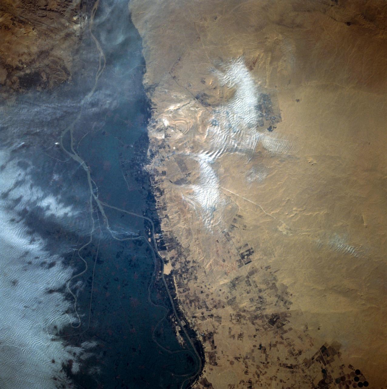
This close-up view of the intensively cultivated Nile River flood plain near Cairo presents a sharp color contrast to the virtually non-vegetated, sandy desert, located to the west of the vegetated area. Some rectangular cultivated field patterns, as well as circular center pivot irrigation patterns, can be observed northwest of the Nile River flood plain. The world famous Giza Pyramids are located near the center of this photography (see highly reflective sand surfaces).
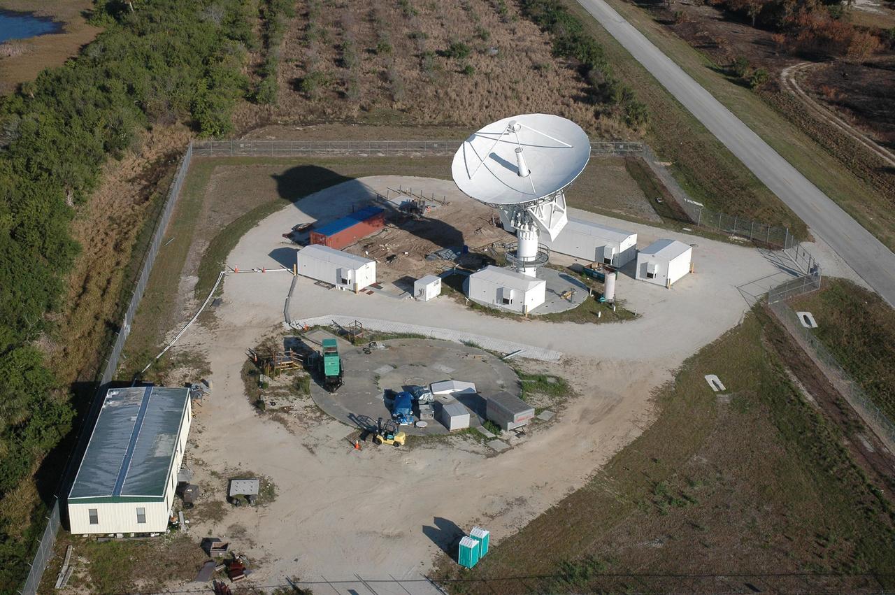
KENNEDY SPACE CENTER, FLA. - This view shows the new C-band, 3 megawatt radar with a 50-foot dish antenna recently installed on north Kennedy Space Center. It is one of the largest of its kind in the world, providing higher definition imagery than has ever been available before. Photo credit: Cory Huston
STS058-101-014 (18 Oct-1 Nov 1993) --- The best, most-nearly cloud-free, shuttle view yet of Mount Everest, the highest mountain in the world at 29,028 feet. The peak, on the border between Nepal and China, is almost exactly in the center of the photograph. The challenging North Face is in shadow; valley glaciers radiate in all directions from the central massif.

Guest view works of art by NASA Apollo 12 Astronaut and Artist Alan Bean during the opening of the show "Alan Bean: Painting Apollo, First Artist on Another World" at the National Air and Space Museum, Monday, July 20, 2009 in Washington. The show opening coincided with the 40th anniversary celebration of Apollo. Photo Credit: (NASA/Bill Ingalls)
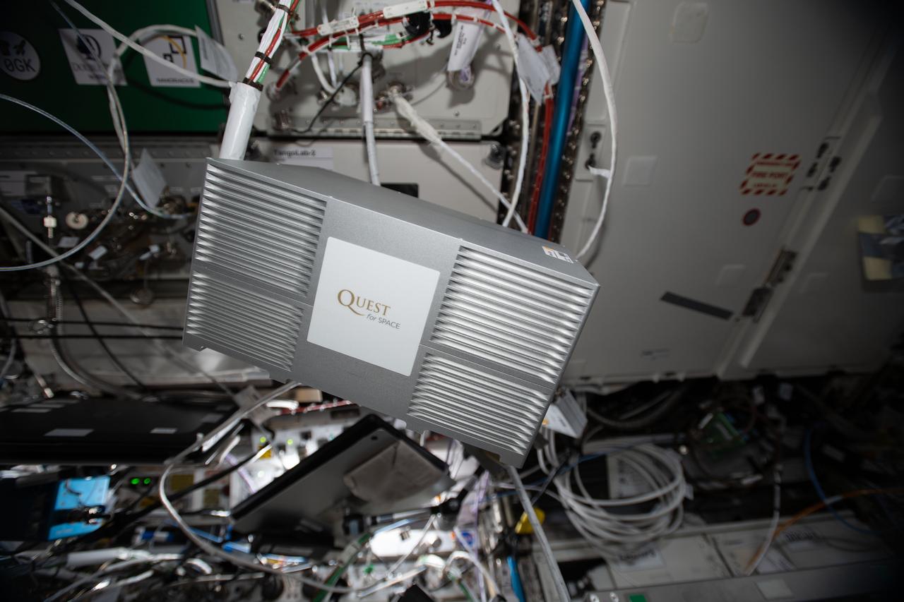
iss062e102749 (3/19/2020) --- A view of the Quest Institute-NanoLab Unit 3 investigation aboard the International Space Station (ISS). Quest Institute-NanoLab Unit 3 contains 15 Nano-Lab experiments from students in the United States and Singapore. Student-developed spaceflight experiments empower students with real-world science experience.

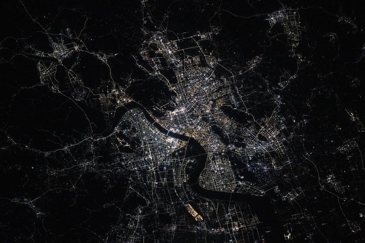
iss073e0763646 (Sept. 21, 2025) --- India’s National Capital Territory of Delhi, home to approximately 34.67 million people, is the second-largest metropolitan area in the world after Tokyo. This nighttime view from the International Space Station, taken at approximately 10:54 p.m. local time, shows the city split by the Yamuna River. The bright rectangular area near the right center marks Indira Gandhi International Airport, one of the busiest aviation hubs in South Asia.
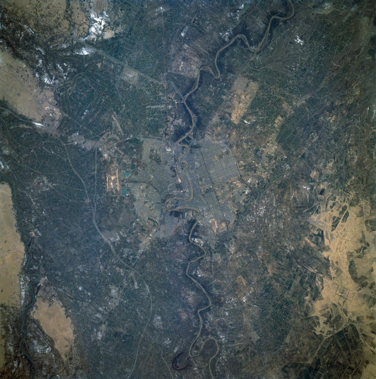
STS060-92-082 (3-11 Feb 1994) --- This cloud-free view is centered on the city of Baghdad, Iraq. Baghdad has had a reputation for scholarship and learning from ancient times in the Islamic world. Modern Baghdad is a city with a typical urban land use patterns. The color of Tigris river flowing through the city indicates the heavily sediment laden waters of the river. Agricultural land uses are evident in the surrounding areas of the city.

iss050e052652 (2/26/2017) --- A view of the Space Test Program - Houston5 (STP-H5). The Space Test Program-H5-Lightning Imaging Sensor (STP-H5 LIS) on the International Space Station (ISS) measures the amount, rate, and energy of lightning around the world. Improved understanding of lightning and its connections to weather provides crucial insight for weather forecasting, climate change, atmospheric chemistry and physics, and aircraft and spacecraft safety.

iss056e012002 (June 14, 2018) --- NASA astronaut Ricky Arnold takes an out-of-this-world "space-selfie" during a spacewalk he conducted with fellow NASA astronaut Drew Feustel (out of frame) on June 14, 2018. During the six-hour, 49-minute spacewalk the duo installed high-definition cameras to provide enhanced views of commercial crew spacecraft, including the SpaceX Crew Dragon and the Boeing Starliner, as they approach and dock with the International Space Station.
ISS040-E-011049 (13 June 2014) --- One of the Expedition 40 crew members aboard the International Space Station photographed this panoramic scene of South Africa and Lesotho on June 13. In the easterly-looking view, Capetown can easily be delineated near bottom center. The country of Lesotho -- one of only three nations in the world which are landlocked and totally surrounded by a single country -- is near the lava plateau at top right.
iss073e0420079 (July 3, 2025) --- Hangzhou, China—home to approximately 13 million people and the southern end of the Grand Canal, the longest artificial river in the world—glows in this nighttime view from the International Space Station. The canal stretches over 1,200 miles from its starting point in Beijing. This photograph was taken at approximately 9:55 p.m. local time while the station was orbiting 259 miles above Earth.
This distant view of Mt. Fuji, on the main home island of Honshu, Japan (34.0N, 139.0E) was taken from about 450 miles to the south. Evan at that great distance, the majestic and inspiring Mt. Fuji is still plainly visible and easily recognized as a world renowned symbol of Japan. The snow capped extinct volcano lies just a few miles south of Tokyo.
STS059-L22-140 (9-20 April 1994) --- View northeastward across Uzbekastan to the partly-ice-covered Aral Sea and Kazakhstan. The irrigated fan-delta of the Amu Darya extends from the right side of the photograph to end in extensive salt flats at the south end of the sea. The Aral was the fourth-largest inland sea or lake in the world, until diversion and over-use of the river water for irrigation led, in this arid climate, to the sea's decline. Linhof camera.

iss056e011992 (June 14, 2018) --- NASA astronaut Ricky Arnold takes an out-of-this-world "space-selfie" during a spacewalk he conducted with fellow NASA astronaut Drew Feustel (out of frame) on June 14, 2018. During the six-hour, 49-minute spacewalk the duo installed high-definition cameras to provide enhanced views of commercial crew spacecraft, including the SpaceX Crew Dragon and the Boeing Starliner, as they approach and dock with the International Space Station.
Saturn's moons Tethys and Hyperion appear to be near neighbors in this Cassini view, even though they are actually 930,000 miles (1.5 million kilometers) apart here. Tethys is the larger body on the left. These two icy moons of Saturn are very different worlds. To learn more about Hyperion (170 miles or 270 kilometers across). This view looks toward the trailing side of Tethys. North on Tethys is up and rotated 1 degree to the left. The image was taken in visible light with the Cassini spacecraft narrow-angle camera on Aug. 15, 2015. The view was acquired at a distance of approximately 750,000 miles (1.2 million kilometers) from Tethys. Image scale is 4.4 miles (7.0 kilometers) per pixel. The distance to Hyperion was 1.7 million miles (2.7 million kilometers) with an image scale of 10 mile (16 kilometers) per pixel. http://photojournal.jpl.nasa.gov/catalog/PIA20493

A member of the U.S. Women's World Cup Soccer Team poses with Astronauts (from left) Steven W. Lindsey, Nancy Jane Currie and Laurel B. Clark. The team arrived at the Skid Strip at Cape Canaveral Air Station with First Lady Hillary Rodham Clinton to view the launch of Space Shuttle mission STS-93. Liftoff is scheduled for 12:36 a.m. EDT July 20. Much attention has been generated over the launch due to Commander Eileen M. Collins, the first woman to serve as commander of a Shuttle mission. The primary payload of the five-day mission is the Chandra X-ray Observatory, which will allow scientists from around the world to study some of the most distant, powerful and dynamic objects in the universe. The new telescope is 20 to 50 times more sensitive than any previous X-ray telescope and is expected to unlock the secrets of supernovae, quasars and black holes

A member of the U.S. Women's World Cup Soccer Team is greeted by NASA Astronaut Scott E. Parazynski (left) upon her arrival at the Skid Strip at Cape Canaveral Air Station as her teammates look on. The team is at KSC to view the launch of Space Shuttle mission STS-93 scheduled for liftoff at 12:36 a.m. EDT July 20. Much attention has been generated over the launch due to Commander Eileen M. Collins, the first woman to serve as commander of a Shuttle mission. The primary payload of the five-day mission is the Chandra X-ray Observatory, which will allow scientists from around the world to study some of the most distant, powerful and dynamic objects in the universe. The new telescope is 20 to 50 times more sensitive than any previous X-ray telescope and is expected to unlock the secrets of supernovae, quasars and black holes

A member of the U.S. Women's World Cup Soccer Team is greeted by NASA Astronaut Heidemarie M. Stefanyshyn-Piper (left) upon her arrival at the Skid Strip at Cape Canaveral Air Station to view the launch of Space Shuttle mission STS-93. Liftoff is scheduled for 12:36 a.m. EDT July 20. Much attention has been generated over the launch due to Commander Eileen M. Collins, the first woman to serve as commander of a Shuttle mission. The primary payload of the five-day mission is the Chandra X-ray Observatory, which will allow scientists from around the world to study some of the most distant, powerful and dynamic objects in the universe. The new telescope is 20 to 50 times more sensitive than any previous X-ray telescope and is expected to unlock the secrets of supernovae, quasars and black holes
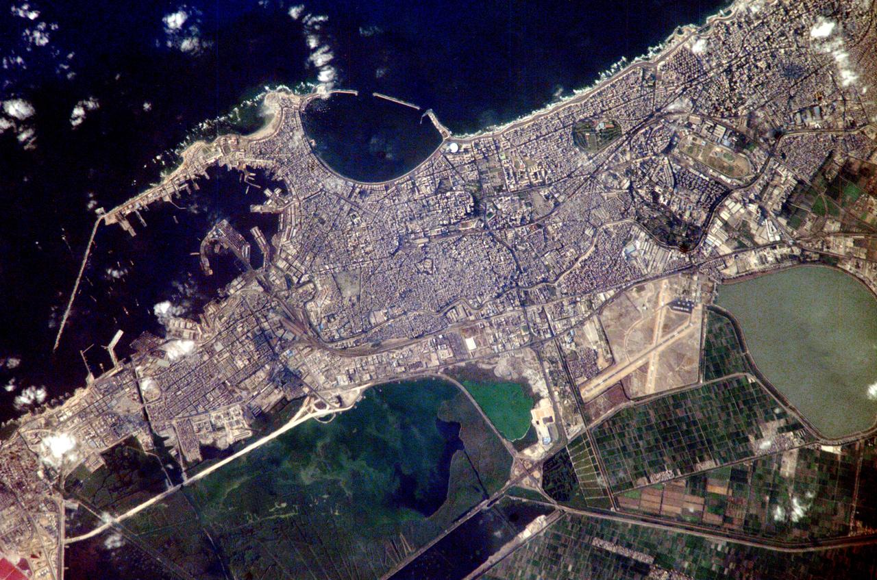
ISS007-E-10960 (27 July 2003) --- Alexandria, Egypt, is featured in this image photographed by an Expedition 7 crewmember on the International Space Station (ISS). Founded by Alexander the Great in 331 BC on the Mediterranean coast of Egypt, Alexandria became a center of trade and learning in the ancient world. Alexander built the causeway between the Eastern and Western Harbors, joining Pharos Island to the mainland. Alexandria’s cultural status was symbolized by the lighthouse on Pharos, one of the “Seven Wonders of the World.” The causeway is still known as the old part of the modern city. Since the year 2000, underwater archeologists have located the sunken palace, ceremonial buildings and port facilities of ancient Alexandria, located along most of the curved southern shoreline of the Eastern Harbor. This detailed image provides a view of the modern port facilities in the Western Harbor, where wharves and many moored ships can be detected.
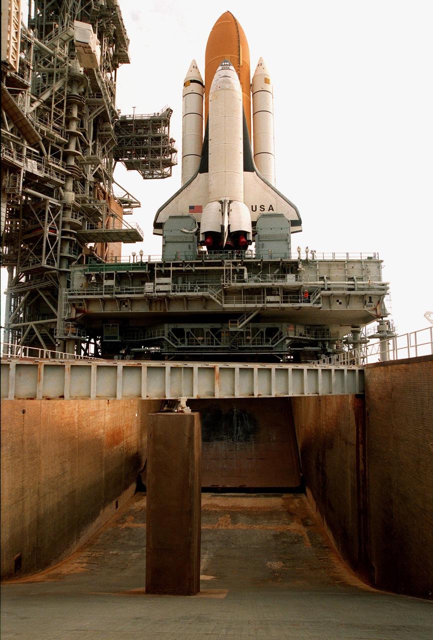
KENNEDY SPACE CENTER, FLA. -- Space Shuttle Columbia sits on Launch Pad 39B in preparation for the launch of STS-93. This view shows the flame trench, 490 feet long and 40 feet high, which helps contain the intense heat that occurs at launch. Columbia was rolled out June 7, less than two weeks after the liftoff of Discovery on mission STS-96. The STS-93 payload is the Chandra X-ray Observatory, the world's most powerful X-ray telescope, which will allow scientists from around the world to see previously invisible black holes and high-temperature gas clouds, giving the observatory the potential to rewrite the books on the structure and evolution of our universe. Columbia (OV-102) is the first of NASA's orbiter fleet, delivered to Kennedy Space Center in March 1979. Columbia initiated the Space Shuttle flight program at KSC when it lifted off Launch Pad 39A on April 12, 1981

Members of the U.S. Women's World Cup Soccer Team were greeted upon their arrival at the Skid Strip at Cape Canaveral Air Station by Astronauts (right) Steven W. Lindsey, Heidemarie M. Stefanyshyn-Piper and Scott E. Parzynski. The team are here to view the launch of Space Shuttle mission STS-93, scheduled for 12:36 a.m. EDT July 20. Much attention has been generated over the launch due to Commander Eileen M. Collins, the first woman to serve as commander of a Shuttle mission. The primary payload of the five-day mission is the Chandra X-ray Observatory, which will allow scientists from around the world to study some of the most distant, powerful and dynamic objects in the universe. The new telescope is 20 to 50 times more sensitive than any previous X-ray telescope and is expected to unlock the secrets of supernovae, quasars and black holes

KENNEDY SPACE CENTER, FLA. -- Members of the U.S. Women's World Cup Soccer Team are greeted by NASA Administrator Daniel S. Goldin as they disembark from a plane at the Skid Strip at Cape Canaveral Air Station. They arrived with First Lady Hillary Rodham Clinton to view the launch of Space Shuttle mission STS-93 scheduled for 12:36 a.m. EDT July 20. Much attention has been generated over the launch due to Commander Eileen M. Collins, the first woman to serve as commander of a Shuttle mission. The primary payload of the five-day mission is the release of the Chandra X-ray Observatory, which will allow scientists from around the world to study some of the most distant, powerful and dynamic objects in the universe
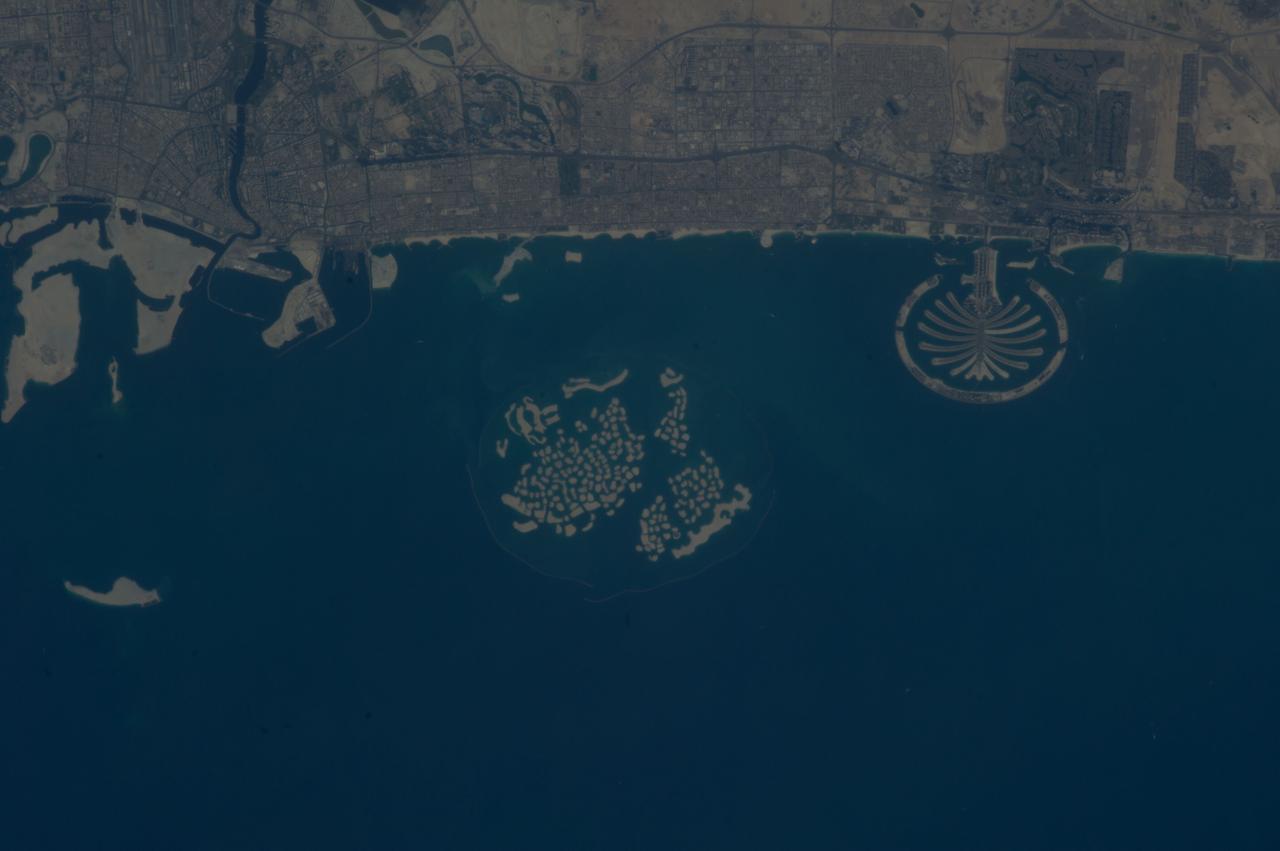
ISS037-E-011470 (14 Oct. 2013) --- Man-made archipelagos near Dubai, United Arab Emirates, are featured in this image photographed by an Expedition 37 crew member on the International Space Station, flying at approximately 220 miles above Earth. The municipality of Dubai is the largest city of the Persian Gulf emirate of the same name, and has built a global reputation for large-scale developments and architectural works. Among the most visible of these developments -- particularly from the perspective of astronauts onboard the space station -- are three man-made archipelagos. The two Palm Islands -- Palm Jumeirah (right) and Palm Jebel Ali (out of frame further to the right) -- appear as stylized palm trees when viewed from above. The World Islands (center frame) evoke a rough map of the world from an air- or space-borne perspective. The Palm Jumeirah project began in 2001 and required more than 50 million cubic meters of dredged sand to raise the islands above the Persian Gulf sea level. Construction of the Palm Jumeirah islands was completed in 2006; for several years now they have been developed for residential and commercial housing and infrastructure. Creation of the World Islands was begun in 2003 and completed in 2008, using 320 million cubic meters of sand and 37 million tons of rock for the surrounding 27 kilometer-long protective breakwater.

STS060-87-087 (3-11 Feb 1994) --- Lake Baikal, in southeastern Siberia, is the largest freshwater lake in the world by volume, holding nearly 20 per cent of the world's fresh water. Lake Baikal is a biospheric reserve of high international interest to the global scientific community. It is home to some 600 endemic species, many found in no other location. This view shows the northern end of the lake, and was taken in the early morning with low sun highlighting the mountain ranges rimming the lake basin. Pristine forests surround the lake, although heavy logging is evident in other photography of the central and southern portions of the lake. Another unique aspect of Lake Baikal is the existence of the world's only known freshwater hydrothermal springs. The fault system which bounds the lake allows fluids to circulate deep into the Earth and resurface as hot springs around and in the lake. Russian and American scientists are using the Shuttle photography to examine the relationship of the lake's ice cover to areas of known hydrothermal activity. Thus Lake Baikal has been and continues to be a high-priority site for photography from space from both the Space Shuttle and the Russian Space Station MIR.
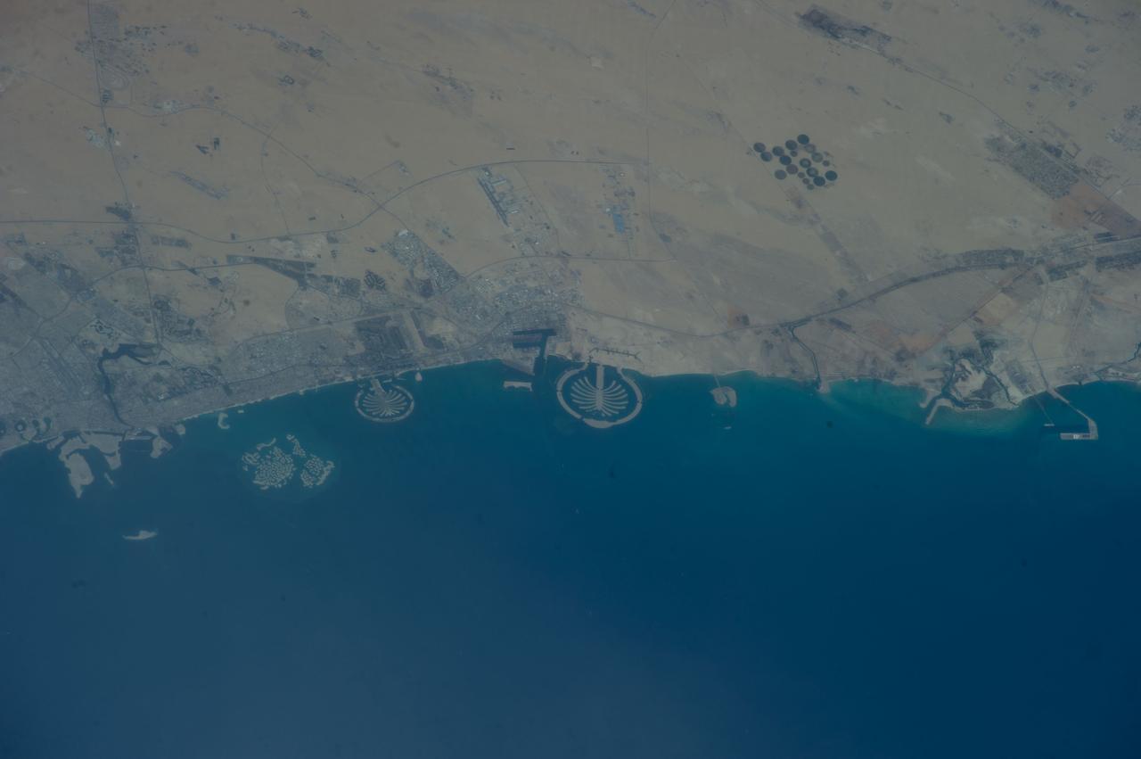
ISS039-E-011515 (13 April 2014) --- Man-made archipelagos near Dubai, United Arab Emirates, are featured in this image photographed by an Expedition 39 crew member on the International Space Station, flying at 220 miles above Earth. The municipality of Dubai is the largest city of the Persian Gulf emirate of the same name, and has built a global reputation for large-scale developments and architectural works. Among the most visible of these developments -- particularly from the perspective of astronauts onboard the ISS -- are three man-made archipelagos. The two Palm Islands -- Palm Jumeirah to the left of center, and Palm Jebel Ali, just to the right of center, appear as stylized palm trees when viewed from above. The World Islands (near left edge) evoke a rough map of the world from an air- or space-borne perspective. The Palm Jumeirah project began in 2001 and required more than 50 million cubic meters of dredged sand to raise the islands above the Persian Gulf sea level. Construction of the Palm Jumeirah islands was completed in 2006; they are now being developed for residential and commercial housing and infrastructure. Creation of the World Islands was begun in 2003 and completed in 2008, using 320 million cubic meters of sand and 37 million tons of rock for the surrounding 27 kilometer-long protective breakwater.
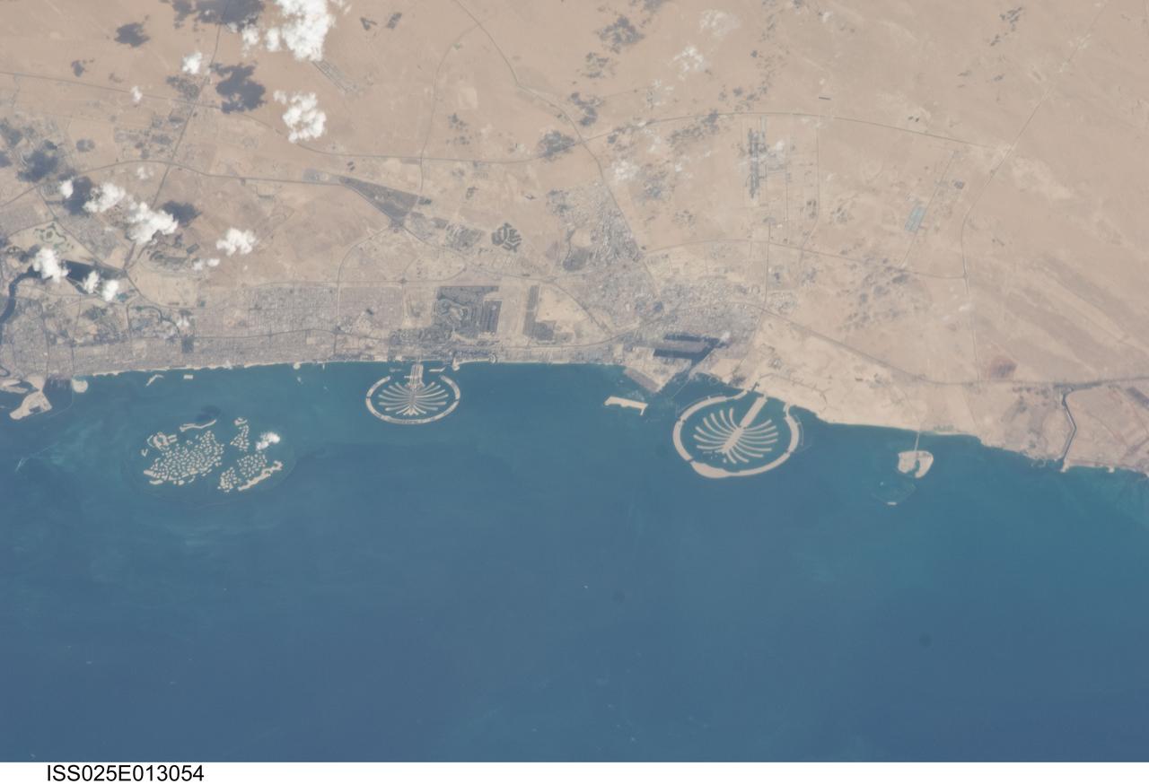
ISS025-E-013054 (7 Nov. 2010) --- Man-made archipelagos near Dubai, United Arab Emirates, are featured in this image photographed by an Expedition 25 crew member on the International Space Station, flying at 220 miles above Earth. The municipality of Dubai is the largest city of the Persian Gulf emirate of the same name, and has built a global reputation for large-scale developments and architectural works. Among the most visible of these developments -- particularly from the perspective of astronauts onboard the ISS -- are three man-made archipelagos. The two Palm Islands -- Palm Jumeirah to the left of center, and Palm Jebel Ali, just to the right of center, appear as stylized palm trees when viewed from above. The World Islands (near left edge) evoke a rough map of the world from an air- or space-borne perspective. The Palm Jumeirah project began in 2001 and required more than 50 million cubic meters of dredged sand to raise the islands above the Persian Gulf sea level. Construction of the Palm Jumeirah islands was completed in 2006; they are now being developed for residential and commercial housing and infrastructure. Creation of the World Islands was begun in 2003 and completed in 2008, using 320 million cubic meters of sand and 37 million tons of rock for the surrounding 27 kilometer-long protective breakwater.
Iapetus is a world of contrast, with light and dark regions fitting together like cosmic puzzle pieces. Cassini Regio on Iapetus (914 miles or 1,471 kilometers across) is covered in a layer of dark, dusty material creating a stark contrast to the much brighter region that surrounds it. This leads to the moon's distinctive, two-toned appearance. This view looks toward Saturn-facing hemisphere of Iapetus. North on Iapetus is up and rotated 20 degrees to the right. The image was taken in visible light with the Cassini spacecraft narrow-angle camera on March 11, 2017. The view was obtained at a distance of approximately 1.6 million miles (2.6 million kilometers) from Iapetus. Image scale is 9 miles (15 kilometers) per pixel. https://photojournal.jpl.nasa.gov/catalog/PIA21332
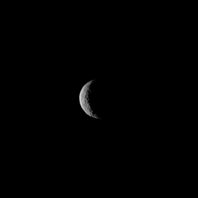
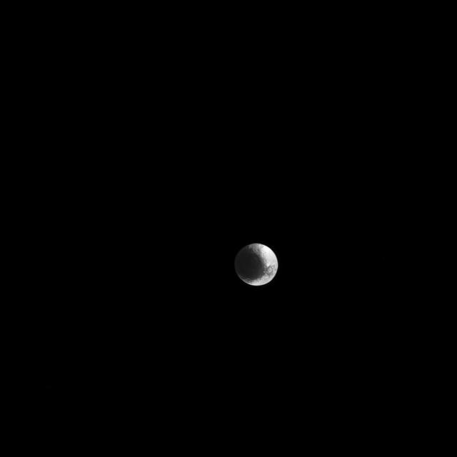
The slim crescent of Ceres smiles back as the dwarf planet awaits the arrival of an emissary from Earth. This image was taken by NASA's Dawn spacecraft on March 1, 2015, just a few days before the mission achieved orbit around the previously unexplored world. Following the image sequence in which this view was acquired, the Dawn spacecraft slipped over to the dark side -- that is, the far side of Ceres with respect to the sun. The spacecraft is slated to resume imaging of Ceres' surface in mid-April, when it once again views lit terrain on Ceres. The image was obtained at a distance of about 30,000 miles (about 48,000 kilometers) at a sun-Ceres-spacecraft angle, or phase angle, of 123 degrees. Image scale on Ceres is 1.9 miles (2.9 kilometers) per pixel. Ceres has an average diameter of about 590 miles (950 kilometers). http://photojournal.jpl.nasa.gov/catalog/PIA19312
![ISS008-E-13304 (28 January 2004) --- This image featuring Mt. Everest and Makalu was taken by an Expedition 8 crewmember on the International Space Station (ISS). Crewmembers on board the Station have a unique view of the world because of their position in a low orbit (200 nautical miles, 360 kilometers) relative to satellites and their ability to look at any angle out the windows of the spacecraft. ISS crewmembers recently took advantage of their vantage point to photograph this oblique view of the Himalayas looking south from over the Tibetan Plateau. At first glance, one might think that the image looks like a picture taken from an airplane; until you remember that the summits of Makalu [left (8,462 meters: 27,765 feet)] and Everest [right (8,850 meters; 29,035 feet)] are at the heights typically flown by commercial aircraft, and could never be seen this way from an airplane.](https://images-assets.nasa.gov/image/iss008e13304/iss008e13304~medium.jpg)
ISS008-E-13304 (28 January 2004) --- This image featuring Mt. Everest and Makalu was taken by an Expedition 8 crewmember on the International Space Station (ISS). Crewmembers on board the Station have a unique view of the world because of their position in a low orbit (200 nautical miles, 360 kilometers) relative to satellites and their ability to look at any angle out the windows of the spacecraft. ISS crewmembers recently took advantage of their vantage point to photograph this oblique view of the Himalayas looking south from over the Tibetan Plateau. At first glance, one might think that the image looks like a picture taken from an airplane; until you remember that the summits of Makalu [left (8,462 meters: 27,765 feet)] and Everest [right (8,850 meters; 29,035 feet)] are at the heights typically flown by commercial aircraft, and could never be seen this way from an airplane.
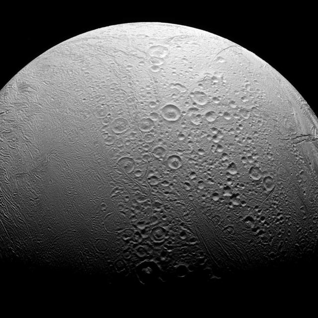
Enceladus is a world divided. To the north, we see copious amounts of craters and evidence of the many impacts the moon has suffered in its history. However, to the south we see a smoother body with wrinkles due to geologic activity. Most solar system bodies lacking an atmosphere are heavily cratered like Enceladus' (313 miles or 504 kilometers across) northern region. However, the geologic activity in the south, including the famous plume above the moon's south pole, can erase craters and leave a younger, smoother-looking surface. This view looks toward the anti-Saturn hemisphere of Enceladus. North on Enceladus is up and rotated 4 degrees to the right. The image was taken in visible light with the Cassini spacecraft narrow-angle camera on Nov. 27, 2016. The view was obtained at a distance of approximately 41,000 miles (66,000 kilometers) from Enceladus. Image scale is 1,310 feet (398 meters) per pixel. http://photojournal.jpl.nasa.gov/catalog/PIA20524

Generating her own attention waiting for the launch of STS-93 at the VIP viewing site is Chelsea Clinton, daughter of the President and Mrs. Clinton. The First Lady and Chelsea arrived earlier to view the launch. Much attention has been generated over STS-93 due to Commander Eileen M. Collins, the first woman to serve as commander of a Shuttle mission. The primary payload of the five-day mission is the Chandra X-ray Observatory, which will allow scientists from around the world to study some of the most distant, powerful and dynamic objects in the universe. The new telescope is 20 to 50 times more sensitive than any previous X-ray telescope and is expected to unlock the secrets of supernovae, quasars and black holes. Liftoff of Space Shuttle Columbia is scheduled for 12:36 a.m. EDT July 20
From a distance Saturn seems to exude an aura of serenity and peace. In spite of this appearance, Saturn is an active and dynamic world. Its atmosphere is a fast-moving and turbulent place with wind speeds in excess of 1,100 miles per hour (1,800 km per hour) in places. The lack of a solid surface to create drag means that there are fewer features to slow down the wind than on a planet like Earth. Mimas, to the upper-right of Saturn, has been brightened by a factor of 2 for visibility. In this view, Cassini was at a subspacecraft latitude of 19 degrees North. The image was taken with the Cassini spacecraft wide-angle camera on Feb. 4, 2015 using a spectral filter centered at 752 nanometers, in the near-infrared portion of the spectrum. The view was obtained at a distance of approximately 1.6 million miles (2.5 million kilometers) from Saturn. Image scale is 96 miles (150 kilometers) per pixel. http://photojournal.jpl.nasa.gov/catalog/pia18314

Attendees of a women's forum held at the Apollo/Saturn V Center, get a guided tour of the Orbiter Processing Facility. The forum included a welcome by Center Director Roy Bridges, remarks by NASA Administrator Daniel Goldin, and a panel discussion, "Past, Present and Future of Space." The attendees are planning to view the launch of STS-93 at the Banana Creek viewing sight. Much attention has been generated over the launch due to Commander Eileen M. Collins, the first woman to serve as commander of a Shuttle mission. The primary payload of the five-day mission is the Chandra X-ray Observatory, which will allow scientists from around the world to study some of the most distant, powerful and dynamic objects in the universe. Liftoff is scheduled for July 20 at 12:36 a.m. EDT

KENNEDY SPACE CENTER, FLA. -- Astronaut Yvonne Cagle (left); Jennifer Harris (center); the Mars 2001 Operations System Development Manager at the Jet Propulsion Laboratory; and Astronaut Ellen Ochoa (right) participate in a panel about "Past, Present and Future of Space," held at a women's forum in the Apollo/Saturn V Center. The forum included a welcome by Center Director Roy Bridges and remarks by Donna Shalala, secretary of Department of Health and Human Services. The attendees are planning to view the launch of STS-93 at the Banana Creek viewing site. Much attention has been generated over the launch due to Commander Eileen M. Collins, the first woman to serve as commander of a Shuttle mission. The primary payload of the five-day mission is the Chandra X-ray Observatory, which will allow scientists from around the world to study some of the most distant, powerful and dynamic objects in the universe. Liftoff is scheduled for July 20 at 12:36 a.m. EDT
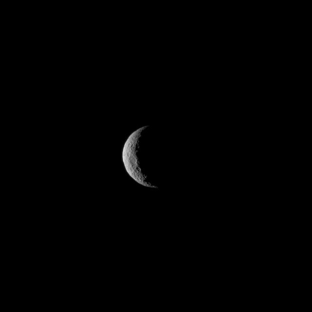
The slim crescent of Ceres smiles back as the dwarf planet awaits the arrival of an emissary from Earth. This image was taken by NASA's Dawn spacecraft on March 1, 2015, just a few days before the mission achieved orbit around the previously unexplored world. Following the image sequence in which this view was acquired, the Dawn spacecraft slipped over to the dark side -- that is, the far side of Ceres with respect to the sun. The spacecraft is slated to resume imaging of Ceres' surface in mid-April, when it once again views lit terrain on Ceres. The image was obtained at a distance of about 30,000 miles (about 48,000 kilometers) at a sun-Ceres-spacecraft angle, or phase angle, of 123 degrees. Image scale on Ceres is 1.9 miles (2.9 kilometers) per pixel. Ceres has an average diameter of about 590 miles (950 kilometers). http://photojournal.jpl.nasa.gov/catalog/PIA19311

STS083-709-030 (4-8 April 1997) --- Panorama over the Nile River, Sinai Peninsula and the Red Sea. Looking past the Orbiter's tail, this view extends from central Egypt eastward to Saudi Arabia on the horizon. Two major water systems, seen in this view, the Nile River and the Red Sea are used for world commerce and transportation in this region. The Nile is flanked immediately by agriculture then beyond by desert. This emphasizes the importance of the river waters to sustain a thriving local population. The Nile River delta is north under the clouds on the upper left-hand corner of the photo. Geologically, the Red Sea is a spreading center between the Arabian and the African Plates, and will continue to widen slowly over a long period of time.
Attendees of a women's forum held at the Apollo/Saturn V Center, get a guided tour of the Orbiter Processing Facility and a closeup look at an orbiter overhead. The forum included a welcome by Center Director Roy Bridges, remarks by NASA Administrator Daniel Goldin, and a panel discussion, "Past, Present and Future of Space." The attendees are planning to view the launch of STS-93 at the Banana Creek viewing sight. Much attention has been generated over the launch due to Commander Eileen M. Collins, the first woman to serve as commander of a Shuttle mission. The primary payload of the five-day mission is the Chandra X-ray Observatory, which will allow scientists from around the world to study some of the most distant, powerful and dynamic objects in the universe. Liftoff is scheduled for July 20 at 12:36 a.m. EDT
SL4-138-3820 (31 Dec. 1973) --- An north-looking oblique view of chains of star sand dunes in eastern Algeria as seen from the Skylab space station in Earth orbit. This picture was taken by one of the Skylab 4 crewmen with a hand-held 70mm Hasselblad camera. The low sun angle of about 25 degrees above horizontal enhances the detail in this picture. The coordinates of the center of the photograph are approximately 29.5 degrees north latitude and 5.0 degrees east longitude in the Grand Erg Oriental. The field of view at the base of the photograph is approximately 200 kilometers (125 miles). The individual dunes are roughly star-shaped rather than simple crescents which are common in dune fields. In this region the stars are aligned along ridges. The causes of these and a wide variety of other dune forms are little understood. Descriptions and photographs from Skylab 4 will be used by the U.S. Geological Survey in their world-wide study of dunes. Photo credit: NASA
Cassini bids farewell to Saturn's yin-and-yang moon, Iapetus. This image is from the last set of observations Cassini made of this world of striking contrasts. The spacecraft helped scientists better understand Iapetus, solving a centuries-old mystery of why it should be bright on one side and dark on the other. Cassini observations of Iapetus (914 mile or 1471 kilometers across) support the prevailing theory that led to the understanding that the dichotomy of the surface is due to a combination of infalling dust from outside of the moon followed by a migration of water ice from the darker (therefore warmer) areas to the cold, brighter surfaces. See PIA11690 for more details. This false-color view is a composite of individual frames obtained using filters sensitive to ultraviolet (centered at 338 nanometers), green (centered at 568 nanometers) and infrared light (centered at 930 nanometers). The view has been enhanced to accentuate subtle color differences and fine-scale surface features. This view looks toward the Saturn-facing hemisphere of Iapetus. North on Iapetus is up and rotated 12 degrees to the left. The view was acquired on May 30, 2017, at a distance of approximately 1.5 million miles (2.5 million kilometers) from Iapetus. Image scale is 9 miles (15 kilometers) per pixel. https://photojournal.jpl.nasa.gov/catalog/PIA21347
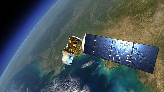
An artist's rendition of the next Landsat satellite, the Landsat Data Continuity Mission (LDCM) that will launch in Feb. 2013. Credit: NASA The Landsat program is the longest continuous global record of Earth observations from space – ever. Since its first satellite went up in the summer of 1972, Landsat has been looking at our planet. The view of Earth that this 40-year satellite program has recorded allows scientists to see, in ways they never imagined, how the Earth's surface has transformed, over time. In the 1970s Landsat captured the first views from space of the Amazonian rainforest and continued to track the area year after year after year, giving the world an unprecedented view of systemic and rapid deforestation. This view from space let us see an activity that was taking place in an exceptionally remote part of our world. These now iconic-images of tropical deforestation spurred the global environmental community to rally in an unprecedented way, and resulted in worldwide attention and action. To read more go to: <a href="http://www.nasa.gov/mission_pages/landsat/news/landsat-history.html" rel="nofollow">www.nasa.gov/mission_pages/landsat/news/landsat-history.html</a> <b><a href="http://www.nasa.gov/audience/formedia/features/MP_Photo_Guidelines.html" rel="nofollow">NASA image use policy.</a></b> <b><a href="http://www.nasa.gov/centers/goddard/home/index.html" rel="nofollow">NASA Goddard Space Flight Center</a></b> enables NASA’s mission through four scientific endeavors: Earth Science, Heliophysics, Solar System Exploration, and Astrophysics. Goddard plays a leading role in NASA’s accomplishments by contributing compelling scientific knowledge to advance the Agency’s mission. <b>Follow us on <a href="http://twitter.com/NASA_GoddardPix" rel="nofollow">Twitter</a></b> <b>Like us on <a href="http://www.facebook.com/pages/Greenbelt-MD/NASA-Goddard/395013845897?ref=tsd" rel="nofollow">Facebook</a></b> <b>Find us on <a href="http://instagrid.me/nasagoddard/?vm=grid" rel="nofollow">Instagram</a></b>
ISS028-E-018675 (23 July 2011) --- Biomass burning in southern Africa is featured in this image photographed by an Expedition 28 crew member on the International Space Station. A smoke pall of subcontinental proportions dominates this view of tropical southern Africa. In what has been described as the most fire-prone part of the world, numerous fires give rise to regional smoke palls every dry season. Fires are both natural and set by local people to clear woodland for agricultural fields. This recent, oblique, northwest-looking view taken in July 2011 at the end of the dry season shows the extent of the smoke on the African plateau?from central Zimbabwe (lower left) to northern Malawi more than 1,000 kilometers away (top right)?and in the wide coastal plains of the lower Zambezi River valley of Mozambique (lower right). Here smoke can be seen blowing inland (left to right), channeled up the Zambezi River valley and contributing to the pall on the plateau. The light gray smoke plumes contrast with higher altitude, brighter patchy cloud cover at lower right. The smoke palls obscure much surface detail, so that Lake Malawi, one of Africa?s Great Lakes, is barely visible, as is Lake Cahora Bassa, Africa?s fourth largest reservoir, in the Zambezi valley. The sun?s reflection off its surface (sunglint) makes Lake Kariba most prominent in the view at left. Kariba is the world?s largest artificial reservoir by volume, and is 220 kilometers long, giving a sense of the scale of the view. The steep, shadowed, mid-afternoon faces of the Inyanga Mountains on the Mozambique-Zimbabwe border protrude above the smoke layer at lower left. Solar panels extending from Russian spacecraft docked at the International Space Station are visible in the foreground at left.
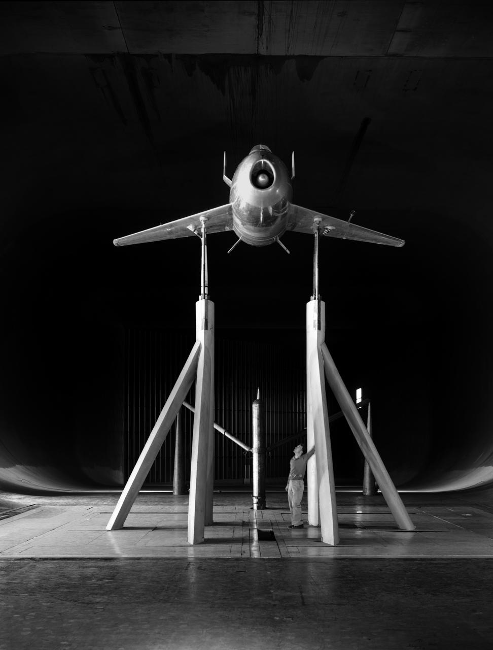
Viewed from the front the #1 XB-70A (62-0001) is shown climbing out during take-off. Most flights were scheduled during the morning hours to take advantage of the cooler ambient air temperatures for improved propulsion efficiencies. The wing tips are extended straight out to provide a maximum lifting wing surface. The XB-70A, capable of flying three times the speed of sound, was the world's largest experimental aircraft in the 1960s. Two XB-70A aircraft were built. Ship #1 was flown by NASA in a high speed flight research program.
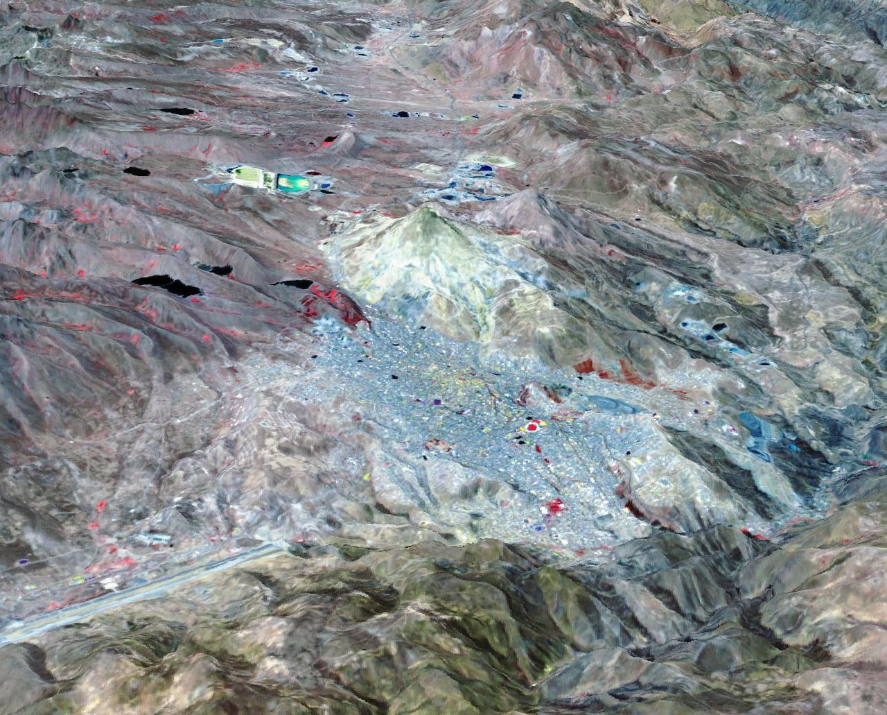
Potosi is the capital city of the Department of Potosi in Bolivia, and one of the highest cities in the world at 4090 m. For centuries it was the location of the Spanish colonial silver mint, the major supplier of silver for the Spanish Empire until the 18th century. Potosi lies at the foot of the Cerro Rico ("rich mountain"), rumored to be made of silver. Today, Potosi continues to be an important mining center, and is famous for its well-preserved colonial architecture. The perspective view covers an area of about 20 by 30 km, was acquired October 12, 2021, and is located at 19.6 degrees south, 65.7 degrees west. https://photojournal.jpl.nasa.gov/catalog/PIA25705
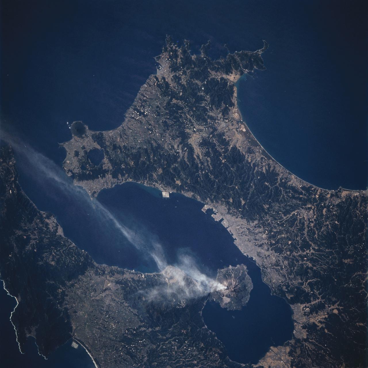
One of the world's most active volcanoes, Sakura-jima in southern-most Kyushu, Japan, erupts dozens of times a year. Volcanic eruptions are so much a part of of daily life in the city of Kagoshima (across the bay and west of Sakura-jima), that school children wear hard hats to school. This photo provides a nice clear view of Sakura-jima on a quiet day - only a plume of steam rises from the summit crater. The summit region is covered with gray ash from the frequent eruptions, and some of the rivers cutting down the mountain (especially the western drainages) appear to be filled with volcanic debris.

NASA Administrator Dan Goldin (left) shares a light moment during his meeting with 10-year-old Jonathan Pierce (right), who is garbed in a protective cooling suit designed by NASA. Behind Goldin is astronaut Doug Wheelock; behind Jonathan is his mother, Penny. Jonathan suffers from erythropoietic protoporphyria, a rare condition that makes his body unable to withstand ultraviolet rays. The suit allows him to be outside during the day, which would otherwise be impossible. Jonathan's trip was funded by the Make-A-Wish Foundation and included a visit to Disney World. He and his family were among a dozen VIPs at KSC to view the launch of STS-99

NASA Administrator Dan Goldin (left) watches as 10-year-old Jonathan Pierce (right), who is garbed in a protective cooling suit designed by NASA, shakes hands with astronaut Dog Wheelock. Behind Jonathan is his mother, Penny. Jonathan suffers from erythropoietic protoporphyria, a rare condition that makes his body unable to withstand ultraviolet rays. The suit allows him to be outside during the day, which would otherwise be impossible. Jonathan's trip was funded by the Make-A-Wish Foundation and included a visit to Disney World. He and his family were among a dozen VIPs at KSC to view the launch of STS-99

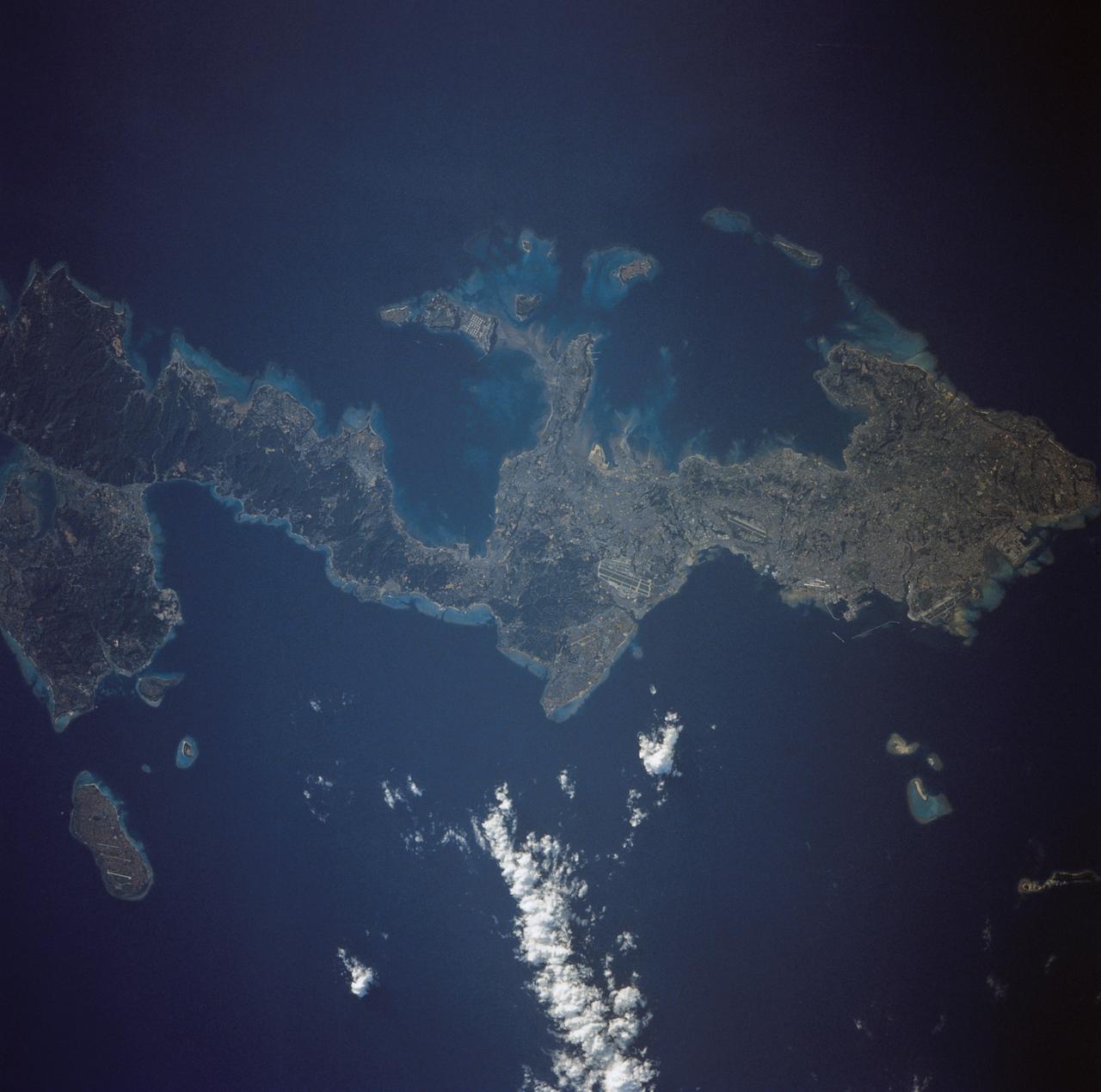
STS100-713-064 (19 April-1 May 2001) --- This southerly-looking view, captured with a 70mm camera onboard the Space Shuttle Endeavour, shows the triangular-shaped island of Sicily. With only very limited coastal plains the island's topography consists of rugged hills and low mountains. Snow-capped Mt. Etna, one of the world's most instrumented volcanoes, is visible near the northeast point of the island. Two other distinctive features in this image are the lighter-colored zone of suspended sediment in the water along the southern coast and, in the distance, the smaller islands of Malta.
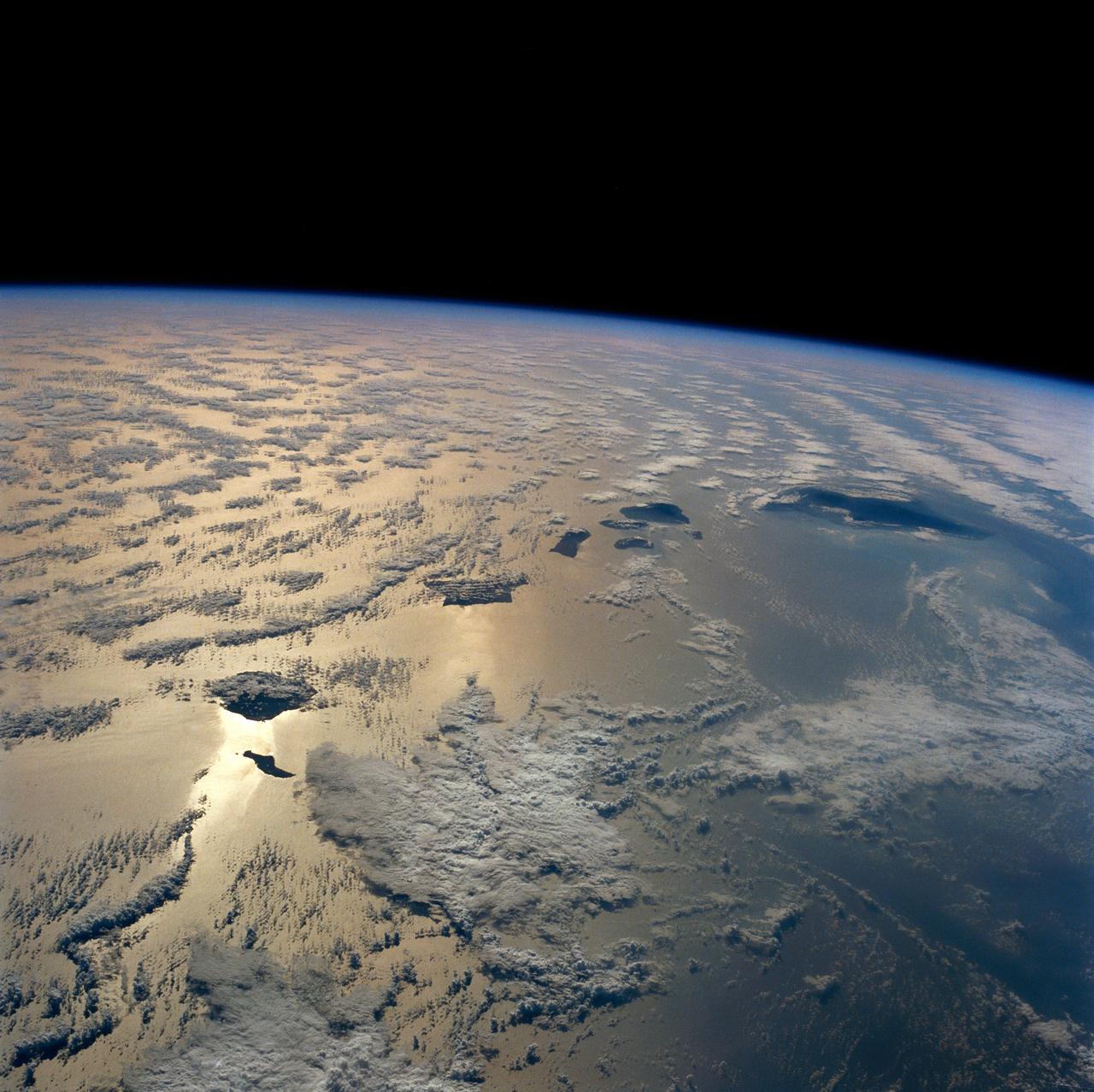
ISS034-E-016601 (4 Jan. 2013) --- On Jan. 4 a large presence of stratocumulus clouds was the central focus of camera lenses which remained aimed at the clouds as the Expedition 34 crew members aboard the International Space Station flew above the northwestern Pacific Ocean about 460 miles east of northern Honshu, Japan. This is a descending pass with a panoramic view looking southeast in late afternoon light with the terminator (upper left). The cloud pattern is typical for this part of the world. The low clouds carry cold air over a warmer sea with no discernable storm pattern.