
Purple Haze
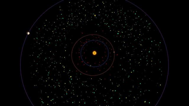
This diagram shows a bird eye view of our asteroid belt, which lies between the orbits of Mars red and Jupiter purple.

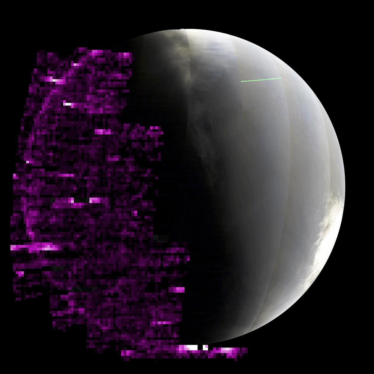
With its thick, distended atmosphere, Titan orange globe shines softly, encircled by a thin halo of purple light-scattering haze
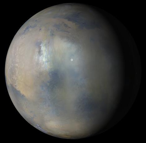
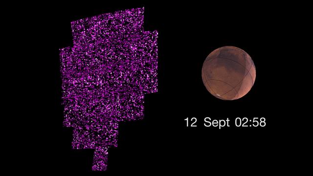
The purple color in this animated GIF shows auroras across Mars' nightside as detected by the Imaging Ultraviolet Spectrograph instrument aboard NASA's MAVEN (Mars Atmosphere and Volatile EvolutioN) orbiter. The brighter the purple, the more auroras were present. Taken as waves of energetic particles from a solar storm were arriving at Mars, the sequence pauses at the end, when the wave of the most energetic particles arrived and overwhelmed the instrument with noise. MAVEN took these images between May 14 and 20, 2024, as the spacecraft orbited below Mars, looking up at the nightside of the planet (Mars' south pole can be seen on the right, in full sunlight). Animation available at https://photojournal.jpl.nasa.gov/catalog/PIA26304

This image from NASA Terra satellite is of Hue, Vietnam. The Perfume River flows through the Capital City, the Imperial City, the Forbidden Purple City and the inner city.

This map shows the topography of the south polar region of Mars. The elevation of the terrain is shown by colors, with purple and blue representing the lowest areas, and orange and red the highest
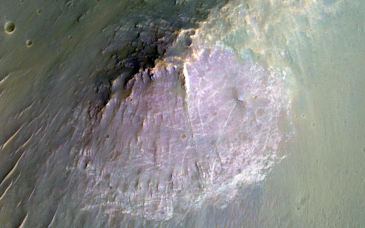
NASA Mars Reconnaissance Orbite observed this image of an isolated mountain in the Southern highlands reveals a large exposure of purplish bedrock. Since HiRISE color is shifted to longer wavelengths than visible color and given relative stretches, this really means that the bedrock is roughly dark in the broad red bandpass image compared to the blue-green and near-infrared bandpass images. In the RGB (red-green-blue) color image, which excludes the near-infrared bandpass image, the bedrock appears bluish in color. This small mountain is located near the northeastern rim of the giant Hellas impact basin, and could be impact ejecta. http://photojournal.jpl.nasa.gov/catalog/PIA19854

Christopher Vedvick, a combat wounded veteran and Military Order of the Purple Heart department of Florida commander, speaks at a Veterans Day observance event on Nov. 7, 2019, in the Kennedy Space Center Training Auditorium. During the event, Kennedy was named a Purple Heart Entity by the Military Order of the Purple Heart, becoming the first NASA center to receive this designation for support and services provided to veterans through the Florida spaceport’s Veterans employee resource group. Attendees included Kennedy employees and more than 20 Purple Heart recipients.

Christopher Vedvick, a combat wounded veteran and Military Order of the Purple Heart department of Florida commander, speaks at a Veterans Day observance event on Nov. 7, 2019, in the Kennedy Space Center Training Auditorium. During the event, Kennedy was named a Purple Heart Entity by the Military Order of the Purple Heart, becoming the first NASA center to receive this designation for support and services provided to veterans through the Florida spaceport’s Veterans employee resource group. Attendees included Kennedy employees and more than 20 Purple Heart recipients.

Christopher Vedvick, a combat wounded veteran and Military Order of the Purple Heart department of Florida commander, speaks at a Veterans Day observance event on Nov. 7, 2019, in the Kennedy Space Center Training Auditorium. During the event, Kennedy was named a Purple Heart Entity by the Military Order of the Purple Heart, becoming the first NASA center to receive this designation for support and services provided to veterans through the Florida spaceport’s Veterans employee resource group. Attendees included Kennedy employees and more than 20 Purple Heart recipients.

Christopher Vedvick, a combat wounded veteran and Military Order of the Purple Heart department of Florida commander, speaks at a Veterans Day observance event on Nov. 7, 2019, in the Kennedy Space Center Training Auditorium. During the event, Kennedy was named a Purple Heart Entity by the Military Order of the Purple Heart, becoming the first NASA center to receive this designation for support and services provided to veterans through the Florida spaceport’s Veterans employee resource group. Attendees included Kennedy employees and more than 20 Purple Heart recipients.

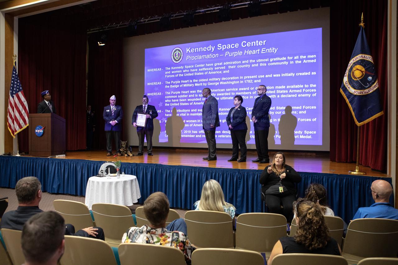
From left, NASA Public Affairs Officer Dustin Cammack, Military Order of the Purple Heart National Adjutant Ernie Rivera, Military Order of the Purple Heart Department of Florida Commander Christopher Vedvick and NASA Public Affairs Officer Derrick Matthews are photographed inside Kennedy Space Center’s Training Auditorium during a Veterans Day observance ceremony on Nov. 7, 2019. During the event, Kennedy was named a Purple Heart Entity by the Military Order of the Purple Heart, becoming the first NASA center to receive this designation for support and services provided to veterans through the Florida spaceport’s Veterans employee resource group. Attendees included Kennedy employees and more than 20 Purple Heart recipients. Following the award presentation, Vedvick, a combat wounded veteran, spoke about his experience serving in the United States Army before retiring, his involvement in the Military Order of the Purple Heart and the purpose of the organization.

Kennedy Space Center Associate Director, Technical, Kelvin Manning speaks during a Veterans Day observance event on Nov. 7, 2019, in the Florida spaceport’s Training Auditorium. During the event, Kennedy was named a Purple Heart Entity by the Military Order of the Purple Heart, becoming the first NASA center to receive this designation for support and services provided to veterans through the center’s Veterans employee resource group. Following this recognition, Christopher Vedvick, a combat wounded veteran and Military Order of the Purple Heart department of Florida commander, spoke about his experience serving in the United States Army before retiring, his involvement in the Military Order of the Purple Heart and the purpose of the organization.

The National Anthem is sung by Suzy Cunningham, NASA Strategy and Integration manager, during a Veterans Day observance ceremony held in the Kennedy Space Center’s Training Auditorium in Florida on Nov. 7, 2019. During the event, Kennedy was named a Purple Heart Entity by the Military Order of the Purple Heart, becoming the first NASA center to receive this designation for support and services provided to veterans through the spaceport’s Veterans employee resource group. Attendees included Kennedy employees and more than 20 Purple Heart recipients. Following the award presentation, Christopher Vedvick, a combat wounded veteran and Military Order of the Purple Heart department of Florida commander, spoke about his experience serving in the United States Army before retiring, his involvement in the Military Order of the Purple Heart and the purpose of the organization.

From left, Kennedy Space Center Associate Director, Technical, Kelvin Manning, Kennedy’s Veterans employee resource group chair Ana Contreras and executive champion Edwin Martinez are photographed with the proclamation designating Kennedy a Purple Heart Entity on Nov. 7, 2019. The proclamation was presented by the Military Order of the Purple Heart during a Veterans Day observance event held in the center’s Training Auditorium. Kennedy is the first NASA center to receive this designation for support and services provided to veterans through the Florida spaceport’s Veterans employee resource group. Attendees included Kennedy employees and more than 20 Purple Heart recipients. Following this, Christopher Vedvick, a combat wounded veteran and Military Order of the Purple Heart department of Florida commander, spoke about his experience serving in the United States Army before retiring, his involvement in the Military Order of the Purple Heart and the purpose of the organization.

NASA Public Affairs Officer Dustin Cammack conducts a prisoner of war, missing in action ceremony at the start of a Veterans Day observance event on Nov. 7, 2019, at the Kennedy Space Center Training Auditorium in Florida. During the event, Kennedy was named a Purple Heart Entity by the Military Order of the Purple Heart, becoming the first NASA center to receive this designation for support and services provided to veterans through the spaceport’s Veterans employee resource group. Attendees included Kennedy employees and more than 20 Purple Heart recipients. Following the award presentation, Christopher Vedvick, a combat wounded veteran and Military Order of the Purple Heart department of Florida commander, spoke about his experience serving in the United States Army before retiring, his involvement in the Military Order of the Purple Heart and the purpose of the organization.

A prisoner of war (POW), missing in action (MIA) table is on display in the Training Auditorium at NASA’s Kennedy Space Center in Florida during a Veterans Day observance event on Nov. 7, 2019. The event began with a POW MIA ceremony, followed by an awards recognition, naming Kennedy a Purple Heart Entity by the Military Order of the Purple Heart. Kennedy is the first NASA center to receive this designation for support and services provided to veterans through the spaceport’s Veterans employee resource group. Attendees included Kennedy employees and more than 20 Purple Heart recipients. Following the award presentation, Christopher Vedvick, a combat wounded veteran and Military Order of the Purple Heart department of Florida commander, spoke about his experience serving in the United States Army before retiring, his involvement in the Military Order of the Purple Heart and the purpose of the organization.

NASA Public Affairs Officer Derrick Matthews serves as emcee during a Veterans Day observance event on Nov. 7, 2019, at the Kennedy Space Center Training Auditorium in Florida. During the event, Kennedy was named a Purple Heart Entity by the Military Order of the Purple Heart, becoming the first NASA center to receive this designation for support and services provided to veterans through the spaceport’s Veterans employee resource group. Attendees included Kennedy employees and more than 20 Purple Heart recipients. Following the award presentation, Christopher Vedvick, a combat wounded veteran and Military Order of the Purple Heart department of Florida commander, spoke about his experience serving in the United States Army before retiring, his involvement in the Military Order of the Purple Heart and the purpose of the organization.

The National Anthem is sung by Suzy Cunningham, NASA Strategy and Integration manager, during a Veterans Day observance ceremony held in the Kennedy Space Center’s Training Auditorium in Florida on Nov. 7, 2019. During the event, Kennedy was named a Purple Heart Entity by the Military Order of the Purple Heart, becoming the first NASA center to receive this designation for support and services provided to veterans through the spaceport’s Veterans employee resource group. Attendees included Kennedy employees and more than 20 Purple Heart recipients. Following the award presentation, Christopher Vedvick, a combat wounded veteran and Military Order of the Purple Heart department of Florida commander, spoke about his experience serving in the United States Army before retiring, his involvement in the Military Order of the Purple Heart and the purpose of the organization.

The National Anthem is sung by Suzy Cunningham, NASA Strategy and Integration manager, during a Veterans Day observance ceremony held in the Kennedy Space Center’s Training Auditorium in Florida on Nov. 7, 2019. During the event, Kennedy was named a Purple Heart Entity by the Military Order of the Purple Heart, becoming the first NASA center to receive this designation for support and services provided to veterans through the spaceport’s Veterans employee resource group. Attendees included Kennedy employees and more than 20 Purple Heart recipients. Following the award presentation, Christopher Vedvick, a combat wounded veteran and Military Order of the Purple Heart department of Florida commander, spoke about his experience serving in the United States Army before retiring, his involvement in the Military Order of the Purple Heart and the purpose of the organization.
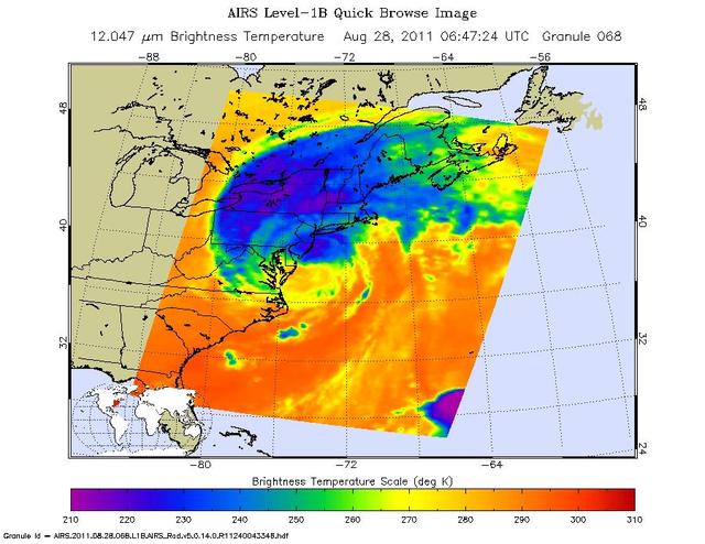
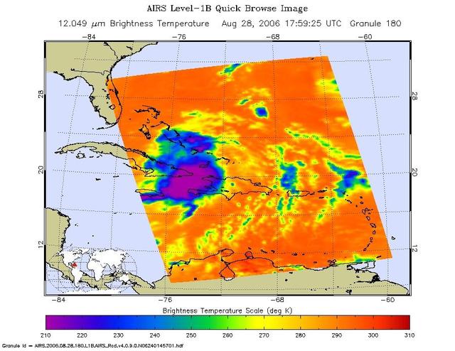
This infrared image of Hurricane Irene from the AIRS instrument on NASA Aqua spacecraft, was taken at 2:47 a.m. EDT on Aug. 28. The storm coldest cloud top temperatures and intense rains are shown in purples and blues.
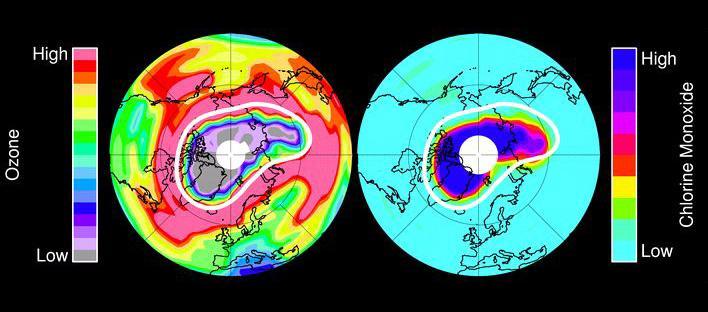
In mid-March 2011, NASA Aura spacecraft observed ozone in Earth stratosphere -- low ozone amounts are shown in purple and grey colors, large amounts of chlorine monoxide are shown in dark blue colors.
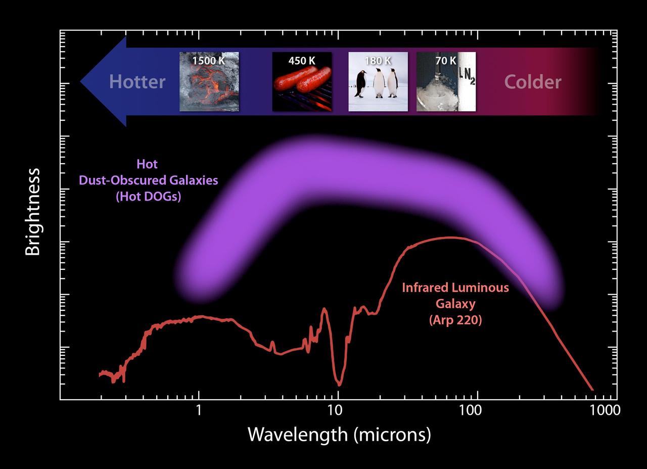
This plot illustrates the new population of hot DOGs, or hot dust-obscured objects, found by WISE. The purple band represents the range of brightness observed for the extremely dusty objects.
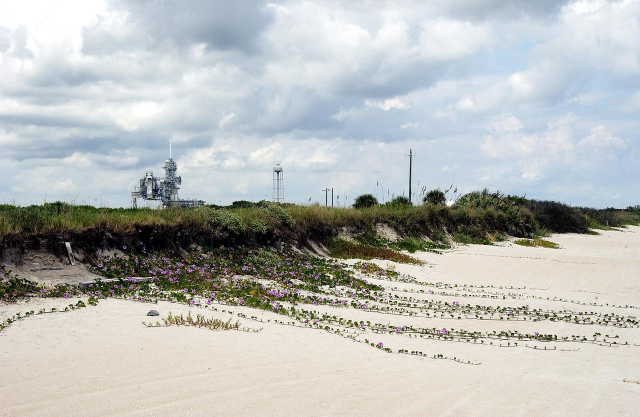
KENNEDY SPACE CENTER, FLA. - The sand dunes facing the Atlantic Ocean near Launch Pad 39A (background) at KSC spill purple flowers down its banks. The beach is just south of the Canaveral National Seashore, managed by the National Wildlife Service.
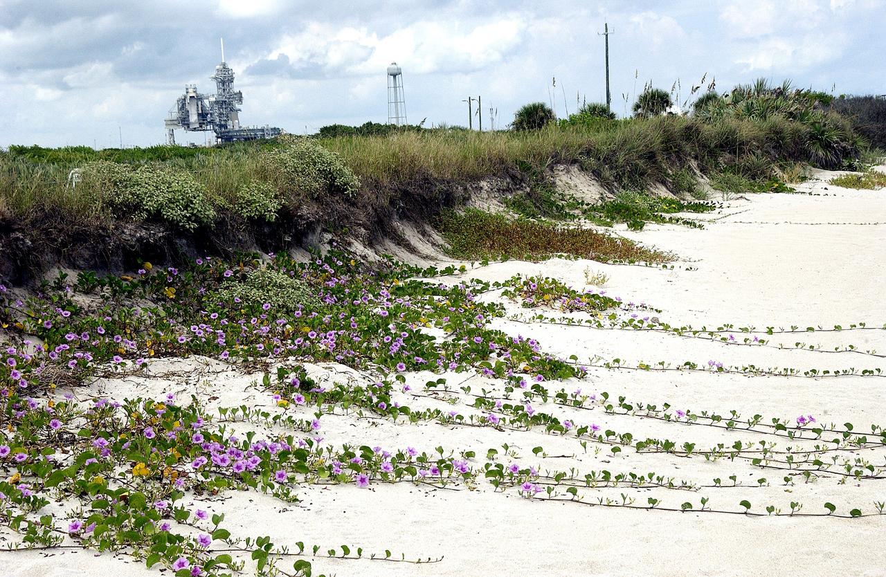
KENNEDY SPACE CENTER, FLA. - Purple flowers flow across the sand from the dunes facing the Atlantic Ocean near Launch Pad 39A (background) at KSC. The beach is just south of the Canaveral National Seashore, which is managed by the National Wildlife Service.

Kennedy Space Center employees attend a Veterans Day observance event on Nov. 7, 2019, in the Florida spaceport’s Training Auditorium. Those employees standing are being recognized for serving in the United States Armed Forces. During the event, Kennedy was named a Purple Heart Entity by the Military Order of the Purple Heart, becoming the first NASA center to receive this designation for support and services provided to veterans through the center’s Veterans employee resource group. Following this recognition, Christopher Vedvick, a combat wounded veteran and Military Order of the Purple Heart department of Florida commander, spoke about his experience serving in the United States Army before retiring, his involvement in the Military Order of the Purple Heart and the purpose of the organization.

Kennedy Space Center employees attend a Veterans Day observance event on Nov. 7, 2019, in the Florida spaceport’s Training Auditorium. Those employees standing are being recognized for serving in the United States Armed Forces. During the event, Kennedy was named a Purple Heart Entity by the Military Order of the Purple Heart, becoming the first NASA center to receive this designation for support and services provided to veterans through the center’s Veterans employee resource group. Following this recognition, Christopher Vedvick, a combat wounded veteran and Military Order of the Purple Heart department of Florida commander, spoke about his experience serving in the United States Army before retiring, his involvement in the Military Order of the Purple Heart and the purpose of the organization.

Christopher Vedvick, left, a combat wounded veteran and Military Order of the Purple Heart department of Florida commander, presents Kennedy Space Center’s Associate Director, Technical, Kelvin Manning with a proclamation designating Kennedy a Purple Heart Entity during a Veterans Day observance event on Nov. 7, 2019, in the Training Auditorium. Kennedy is the first NASA center to receive this designation for support and services provided to veterans through the Florida spaceport’s Veterans employee resource group. Attendees included Kennedy employees and more than 20 Purple Heart recipients. Following this recognition, Vedvick, spoke about his experience serving in the United States Army before retiring, his involvement in the Military Order of the Purple Heart and the purpose of the organization.

Christopher Vedvick, left, a combat wounded veteran and Military Order of the Purple Heart department of Florida commander, presents Kennedy Space Center’s Associate Director, Technical, Kelvin Manning with a proclamation designating Kennedy a Purple Heart Entity during a Veterans Day observance event on Nov. 7, 2019, in the Training Auditorium. Kennedy is the first NASA center to receive this designation for support and services provided to veterans through the Florida spaceport’s Veterans employee resource group. Attendees included Kennedy employees and more than 20 Purple Heart recipients. Following this recognition, Vedvick, spoke about his experience serving in the United States Army before retiring, his involvement in the Military Order of the Purple Heart and the purpose of the organization.
NASA Public Affairs Officer Derrick Matthews (far left) reads a proclamation by the Military Order of the Purple Heart designating Kennedy Space Center a Purple Heart Entity during a Veterans Day observance event in Kennedy’s Training Auditorium in Florida on Nov. 7, 2019. Following the reading, Military Order of the Purple Heart National Adjutant Ernie Rivera (second from left) and Department of Florida Commander Christopher Vedvick presented Kennedy’s Associate Director, Technical, Kelvin Manning (third from right), and the Veterans employee resource group chair Ana Contreras and executive champion Edwin Martinez, with a plaque stating this recognition. Kennedy is the first NASA center to receive this designation for support and services provided to veterans through the spaceport’s Veterans employee resource group. Attendees included Kennedy employees and more than 20 Purple Heart recipients. Following the award presentation, Vedvick, a combat wounded veteran, spoke about his experience serving in the United States Army before retiring, his involvement in the Military Order of the Purple Heart and the purpose of the organization.

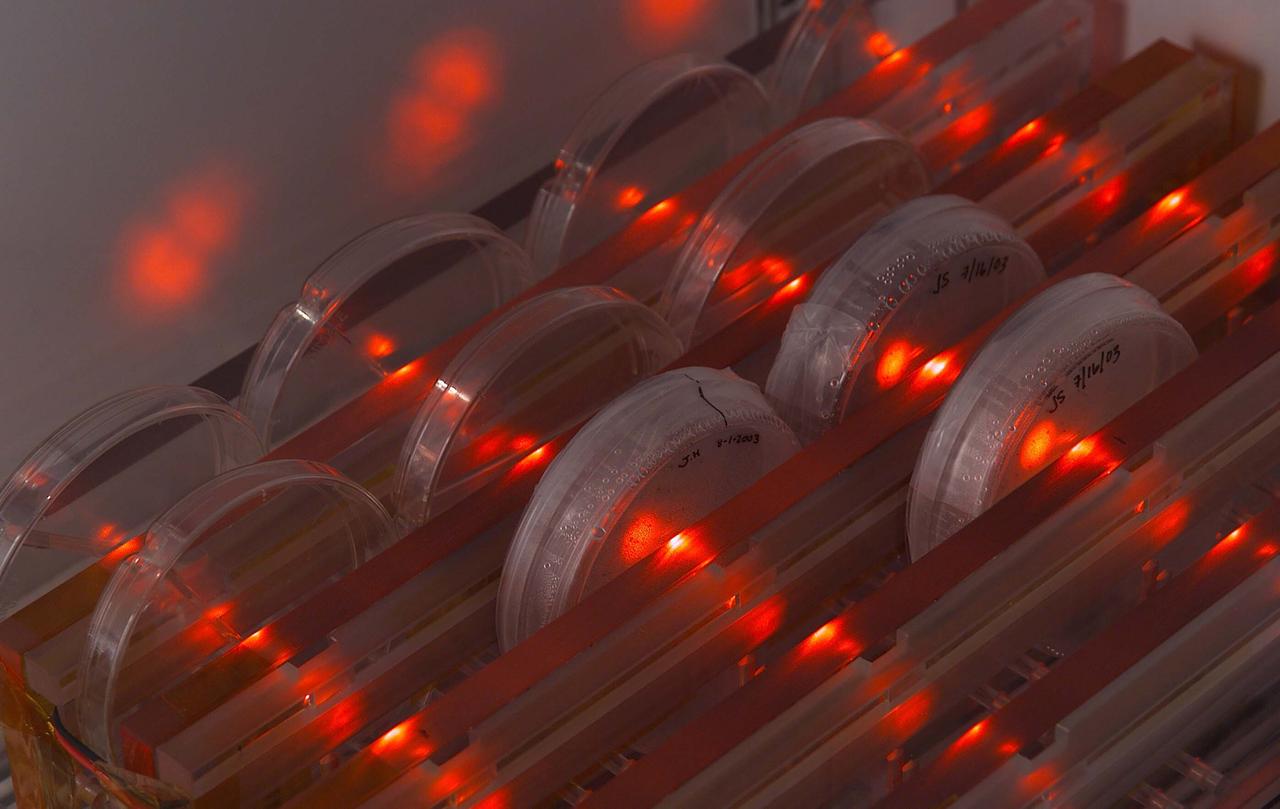
SSBRP Incubator/Small Payloads Development (N-261 Lab 1) with petrie dish speciems, led (red) lights and purple gloved hand

SSBRP Incubator/Small Payloads Development (N-261 Lab 1) with petrie dish speciems, led (red) lights and purple gloved hand
SSBRP Incubator/Small Payloads Development (N-261 Lab 1) with petrie dish speciems, led (red) lights and purple gloved hand

SSBRP Incubator/Small Payloads Development (N-261 Lab 1) with petrie dish speciems, led (red) lights and purple gloved hand

SSBRP Incubator/Small Payloads Development (N-261 Lab 1) with petrie dish speciems, led (red) lights and purple gloved hand

SSBRP Incubator/Small Payloads Development (N-261 Lab 1) with petrie dish speciems, led (red) lights and purple gloved hand
SSBRP Incubator/Small Payloads Development (N-261 Lab 1) with petrie dish speciems, led (red) lights and purple gloved hand

SSBRP Incubator/Small Payloads Development (N-261 Lab 1) with petrie dish speciems, led (red) lights and purple gloved hand

SSBRP Incubator/Small Payloads Development (N-261 Lab 1) with petrie dish speciems, led (red) lights and purple gloved hand

SSBRP Incubator/Small Payloads Development (N-261 Lab 1) with petrie dish speciems, led (red) lights and purple gloved hand

SSBRP Incubator/Small Payloads Development (N-261 Lab 1) with petrie dish speciems, led (red) lights and purple gloved hand
While the curtain-like auroras we see at Earth are green at bottom and red at top, NASA Cassini spacecraft has shown us similar curtain-like auroras at Saturn that are red at bottom and purple at top. This is how the auroras would look to the human eye.
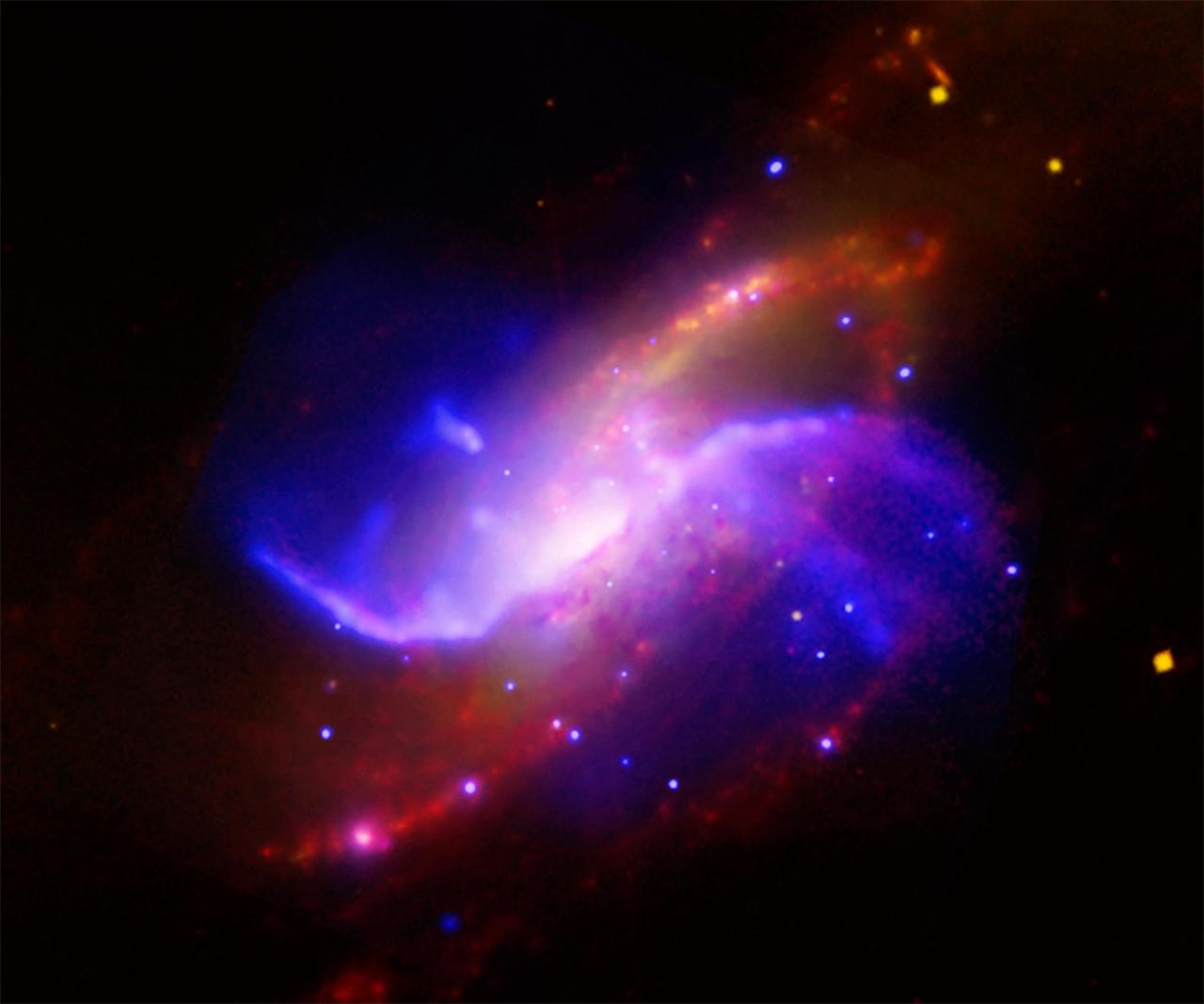
This composite image is of spiral galaxy M106 NGC 4258; optical data from the Digitized Sky Survey is yellow, radio data from the Very Large Array is purple, X-ray data from Chandra is blue, and infrared data from the Spitzer Space Telescope is red.

This image shows two companion galaxies, NGC 4625 top and NGC 4618 bottom, and their surrounding cocoons of cool hydrogen gas purple. The huge set of spiral arms on NGC 4625 blue was discovered by the ultraviolet eyes of NASA GALEX.

This composite image of the star cluster NGC 28 contains X-ray data from Chandra, in purple, with infrared observations from Spitzer, in red, green, blue. NGC 281 is known informally as the Pacman Nebula because of its appearance in optical images.

A small galaxy, called Sextans A, is shown here in a multi-wavelength mosaic captured by the ESA Herschel mission. In this image, the purple shows gas; blue shows young stars and the orange and yellow dots are newly formed stars heating up dust.
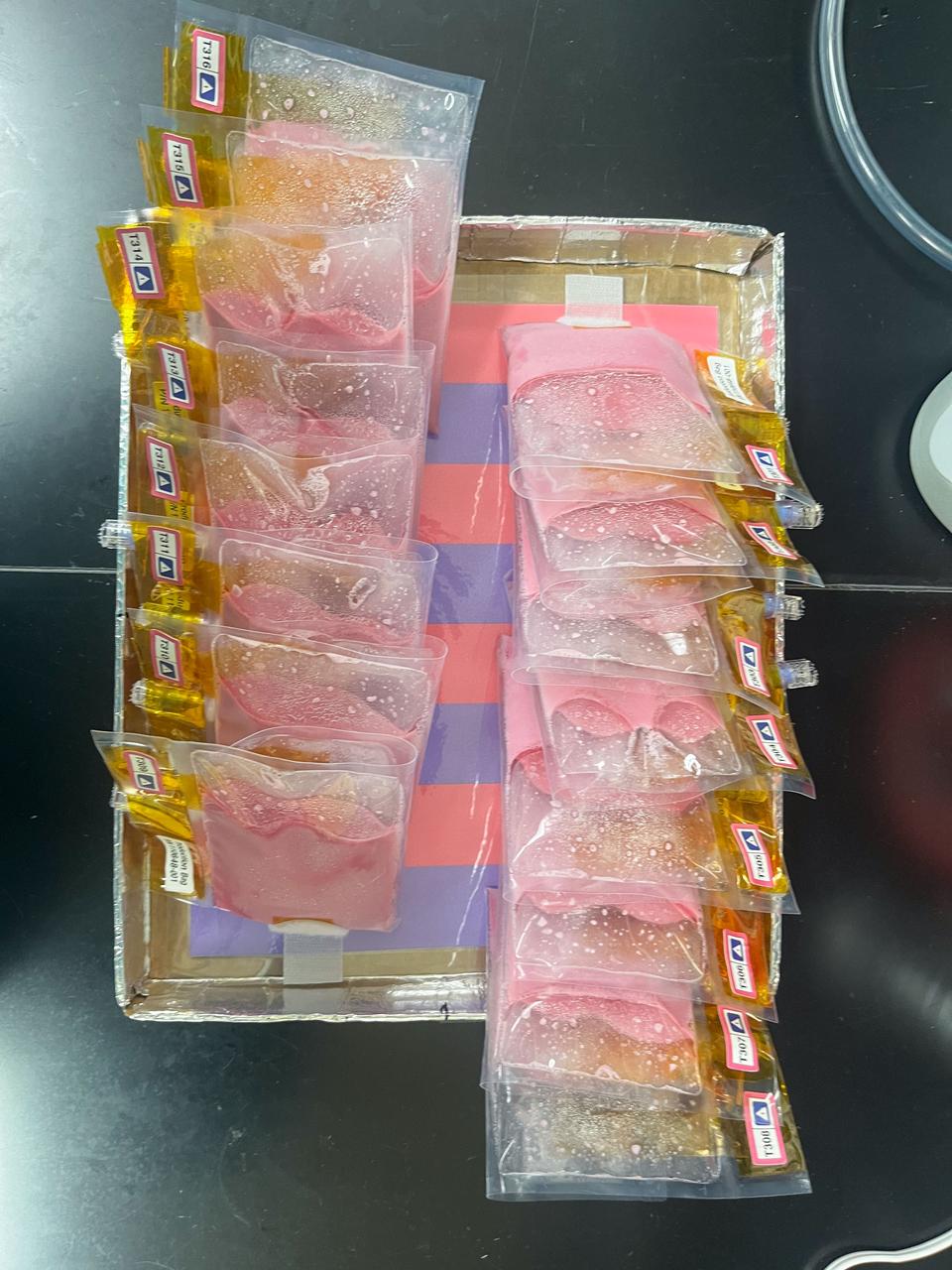
Sixteen BioNutrients-3 yogurt bags attached to the SABL Tray mockup during the BioNutrients-3 Experiment Verification Test. Below the bags, the purple and pink SABL interface board, which is used for pH comparison, is visible. The pink color of the bags indicates that these yogurt bags have completed their incubation, causing the pH indicator to change from purple to pink. Photo Credit: NASA Ames
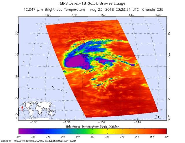
This image shows Hurricane Lane as observed by the Atmospheric Infrared Sounder (AIRS) instrument on NASA's Aqua satellite on Thursday, Aug. 23, 2018. Purple shows very cold clouds high in the atmosphere above the center of the hurricane, blue and green show the warmer temperatures of lower clouds surrounding the storm center; and orange and red areas have almost no clouds. No eye is seen in this image, which means it was either too small for AIRS to detect or it was covered by high, cold clouds. Figure 1 was observed on Aug. 22, 2018. Purple shows very cold clouds high in the atmosphere above the center of the hurricane, blue and green show the warmer temperatures of lower clouds surrounding the storm center; and orange and red areas have almost no clouds. The eye of the storm is clearly visible. https://photojournal.jpl.nasa.gov/catalog/PIA22493
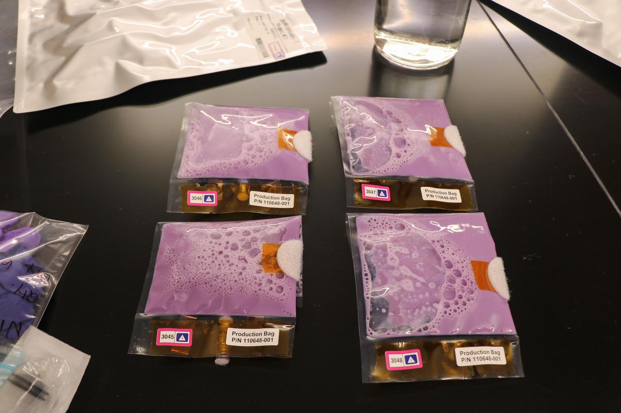
Four BioNutrients-3 yogurt bags, following completion of hydration but before incubation. Note the purple color indicating that the samples have not yet been incubated. o Photo Credit: Kevin Sims (NASA Ames)
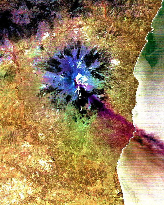
The current eruption of Mt. Etna started on July 17, and has continued to the present. This ASTER image was acquired on Sunday, July 29 and shows the sulfur dioxide plume (in purple) originating form the summit, drifting over the city of Catania, and continuing over the Ionian Sea. ASTER's unique combination of multiple thermal infrared channels and high spatial resolution allows the determination of the thickness and position of the SO2 plume. The image covers an area of 24 x 30 km. The image is centered at 37.7 degrees north latitude, 15 degrees east longitude. http://photojournal.jpl.nasa.gov/catalog/PIA02678

The latest remote sensing data from NASA's Jason satellite show that the equatorial Pacific sea surface levels are higher, indicating warmer sea surface temperatures in the central and west Pacific Ocean. This pattern has the appearance of La Niña rather than El Niño. This contrasts with the Bering Sea, Gulf of Alaska and U.S. West Coast where lower-than-normal sea surface levels and cool ocean temperatures continue (indicated by blue and purple areas). The image above is a global map of sea surface height, accurate to within 30 millimeters. The image represents data collected and composited over a 10-day period, ending on Jan 23, 2004. The height of the water relates to the temperature of the water. As the ocean warms, its level rises; and as it cools, its level falls. Yellow and red areas indicate where the waters are relatively warmer and have expanded above sea level, green indicates near normal sea level, and blue and purple areas show where the waters are relatively colder and the surface is lower than sea level. The blue areas are between 5 and 13 centimeters (2 and 5 inches) below normal, whereas the purple areas range from 14 to 18 centimeters (6 to 7 inches) below normal. http://photojournal.jpl.nasa.gov/catalog/PIA05071

Date: 02-11-15 Loction: Bldg 9NW Subject: Expedition 50 crew members Shane Kimbrough and Thomas Pesquet during ISS EVA Fluid QD Ops 1 with instructors Allissa Battocletti(purple) and Staphanie Johnston. Photographer: James Blair

jsc2022e072966 (8/12/2022) --- A view of the OVOSPACE payload during a functional test. The science of the payload resides within the Nanoracks purple aluminum chassis. This chassis provides an interface to the Nanoracks Nanode platform. Nanode provides payloads with power and data throughout their time in space. Image courtesy of Nanoracks LLC.
![Color from the High Resolution Imaging Science Experiment (HiRISE) instrument onboard NASA's Mars Reconnaissance Orbiter can show mineralogical differences due to the near-infrared filter. The sources of channels on the north rim of Hale Crater show fresh blue, green, purple and light toned exposures under the the overlying reddish dust. The causes and timing of activity in channels and gullies on Mars remains an active area of research. Geologists infer the timing of different events based on what are called "superposition relationships" between different landforms. Areas like this are a puzzle. The map is projected here at a scale of 25 centimeters (9.8 inches) per pixel. [The original image scale is 25.2 centimeters (9.9 inches) per pixel (with 1 x 1 binning); objects on the order of 76 centimeters (29.9 inches) across are resolved.] North is up. https://photojournal.jpl.nasa.gov/catalog/PIA21586](https://images-assets.nasa.gov/image/PIA21586/PIA21586~medium.jpg)
Color from the High Resolution Imaging Science Experiment (HiRISE) instrument onboard NASA's Mars Reconnaissance Orbiter can show mineralogical differences due to the near-infrared filter. The sources of channels on the north rim of Hale Crater show fresh blue, green, purple and light toned exposures under the the overlying reddish dust. The causes and timing of activity in channels and gullies on Mars remains an active area of research. Geologists infer the timing of different events based on what are called "superposition relationships" between different landforms. Areas like this are a puzzle. The map is projected here at a scale of 25 centimeters (9.8 inches) per pixel. [The original image scale is 25.2 centimeters (9.9 inches) per pixel (with 1 x 1 binning); objects on the order of 76 centimeters (29.9 inches) across are resolved.] North is up. https://photojournal.jpl.nasa.gov/catalog/PIA21586

The foreground of this scene from the Mast Camera (Mastcam) on NASA's Curiosity Mars rover shows purple-hued rocks near the rover's late-2016 location on lower Mount Sharp. The scene's middle distance includes higher layers that are future destinations for the mission. Variations in color of the rocks hint at the diversity of their composition on lower Mount Sharp. The purple tone of the foreground rocks has been seen in other rocks where Curiosity's Chemical and Mineralogy (CheMin) instrument has detected hematite. Winds and windblown sand in this part of Curiosity's traverse and in this season tend to keep rocks relatively free of dust, which otherwise can cloak rocks' color. The three frames combined into this mosaic were acquired by the Mastcam's right-eye camera on Nov. 10, 2016, during the 1,516th Martian day, or sol, of Curiosity's work on Mars. The scene is presented with a color adjustment that approximates white balancing, to resemble how the rocks and sand would appear under daytime lighting conditions on Earth. Sunlight on Mars is tinged by the dusty atmosphere and this adjustment helps geologists recognize color patterns they are familiar with on Earth. The view spans about 15 compass degrees, with the left edge toward southeast. The rover's planned direction of travel from its location when this scene was recorded is generally southeastward. The orange-looking rocks just above the purplish foreground ones are in the upper portion of the Murray formation, which is the basal section of Mount Sharp, extending up to a ridge-forming layer called the Hematite Unit. Beyond that is the Clay Unit, which is relatively flat and hard to see from this viewpoint. The next rounded hills are the Sulfate Unit, Curiosity's highest planned destination. The most distant slopes in the scene are higher levels of Mount Sharp, beyond where Curiosity will drive. Figure 1 is a version of the same scene with annotations added as reference points for distance, size and relative elevation. The annotations are triangles with text telling the distance (in kilometers) to the point in the image marked by the triangle, the point's elevation (in meters) relative to the rover's location, and the size (in meters) of an object as big as the triangle at that distance. An annotated figure is available at http://photojournal.jpl.nasa.gov/catalog/PIA21256
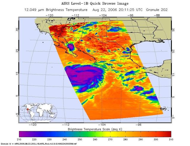
This is an infrared image of Hurricane Ileana in the Eastern Pacific, from the Atmospheric Infrared Sounder (AIRS) on NASA's Aqua satellite on August 22, 2006. This AIRS image shows the temperature of the cloud tops or the surface of the Earth in cloud-free regions. The lowest temperatures (in purple) are associated with high, cold cloud tops that make up the top of the storm. The infrared signal does not penetrate through clouds. Where there are no clouds the AIRS instrument reads the infrared signal from the surface of the Earth, revealing warmer temperatures (red). http://photojournal.jpl.nasa.gov/catalog/PIA00509
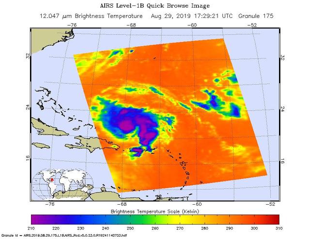
An infrared image of Hurricane Dorian, as seen by the AIRS instrument aboard NASA's Aqua satellite at 1:30 p.m. EDT (10:30 a.m. PDT) on Aug. 29, 2019. The large purple areas are cold clouds, carried high into the atmosphere by deep thunderstorms. Blue and green show warmer areas with less rain clouds, while orange and red represent mostly cloud-free air. https://photojournal.jpl.nasa.gov/catalog/PIA23358
This image shows the southern wall of Coprates Chasma, in the equatorial canyon system of Valles Marineris. While much of the lower slopes are covered by sand, exposed bedrock is clearly visible in the upper canyon walls. In an enhanced color image, the varying colors – shades of white, cyan, and purple – are suggestive of multiple minerals being present within the bedrock, indicating a complicated geologic history, possibly involving alteration by water. (In this cutout, north is down.) https://photojournal.jpl.nasa.gov/catalog/PIA25985

The early-morning Sun bathes the Space Shuttle Discovery in hues of purple, pink and gold as it is encased in the Mate-Demate Device (MDD) at NASA’s Dryden Flight Research Center at Edwards, California. The gantry-like MDD structure is used to prepare the shuttle for its ferry flight back to the Kennedy space Center in Florida, including mounting the shuttle atop NASA’s modified Boeing 747 Shuttle Carrier Aircraft.
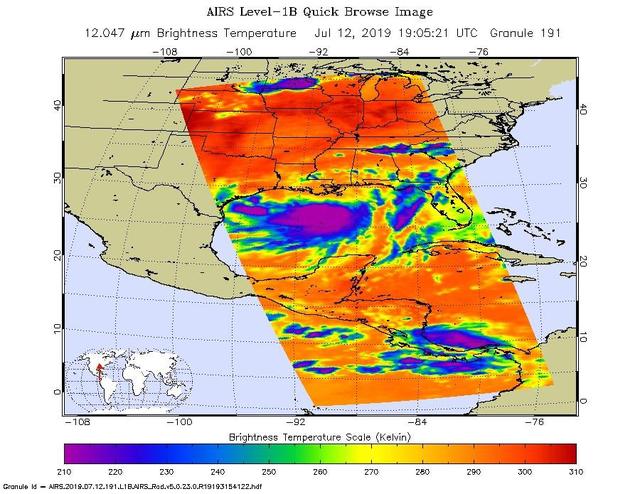
NASA's AIRS instrument imaged Tropical Storm Barry on the afternoon of July 12, 2019, a day before the storm is expected to make landfall on the Louisiana Coast. The infrared image shows very cold clouds that have been carried high into the atmosphere by deep thunderstorms in purple. These clouds are associated with heavy rainfall. Warmer areas with shallower rain clouds are shown in blue and green. And the orange and red areas represent mostly cloud-free air. https://photojournal.jpl.nasa.gov/catalog/PIA23355

This cross section of the Earth's atmosphere at sunset and earth limb (24.5S, 43.5E) displays an unusual layering believed to be caused by temperature inversions which effectively concentrate smoke, dust and aerosols into narrow layers. the top of the stratosphere can be seen as the top of the white layer thought to contain volcanic debris. The purple layer is the troposphere containing smoke from landclearing biomass burning.

Stable, south flowing air over the western Pacific Ocean (26.0N, 131.0E) is disturbed by islands south of Korea, resulting in sinuous clouds known as von Karman vortices. The smoke plume from Japan's Mount Unzen Volcano on Kyushu, is visible just west of the large cloud mass and extending southward. A very large, purple tinged dust pall, originating in Mongolia, can be seen on the Earth's Limb, covering eastern China and extending into the East China Sea.

KENNEDY SPACE CENTER, FLA. - Purple-plumed grass waves gently in the breeze. The grass abounds within and around Kennedy Space Center, which shares a boundary with the Merritt Island National Wildlife Refuge. Approximately one-half of the refuge’s 140,000 acres consists of brackish estuaries and marshes. The remaining lands consist of coastal dunes, scrub oaks, pine forests and flatwoods, and palm and oak hammocks.

ISS030-E-177670 (28 March 2012) --- One of the Expedition 30 crew members photographed this nighttime scene while the International Space Station was flying at an altitude approximately 240 miles over the eastern North Atlantic. The view looks northeastward. Center point coordinates are 46.8 degrees north latitude and 14.3 degrees west longitude. The night lights of the cities of Ireland, in the foreground, and the United Kingdom, in the back and to the right, are contrasted by the bright sunrise in the background. The greens and purples of the Aurora Borealis are seen along the rest of the horizon.
99-E-10022 (23 July 1999) --- The Chandra X-Ray observatory was recorded with the STS-93 HDTV Camcorder as it moved from its stowed position in the cargo bay of the Space Shuttle Columbia. The blue and purple airglow over Earth's horizon forms part of the backdrop for the scene. Deployment of the giant telescope occurred only hours after the shuttle reached Earth orbit.
This animated gif depicts the point of view of NASA's Juno spacecraft during its eclipse-free approach to the gas giant Nov. 3, 2019. The Sun is depicted as the yellow dot rising up just to left of the planet. Located at the north and south poles, the gas giant's auroras are shown in purple. Jupiter's tenuous rings are shown gray. Animation available at https://photojournal.jpl.nasa.gov/catalog/PIA23465
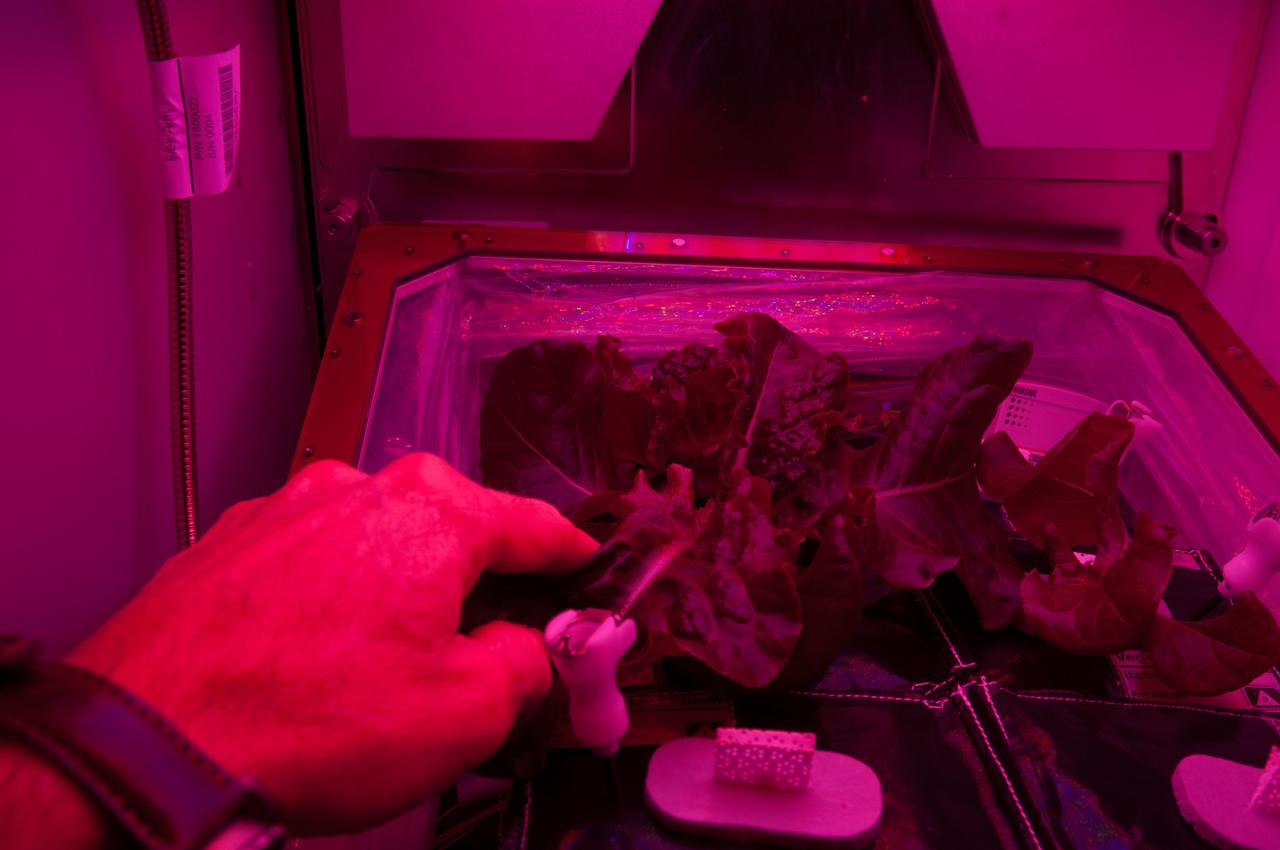
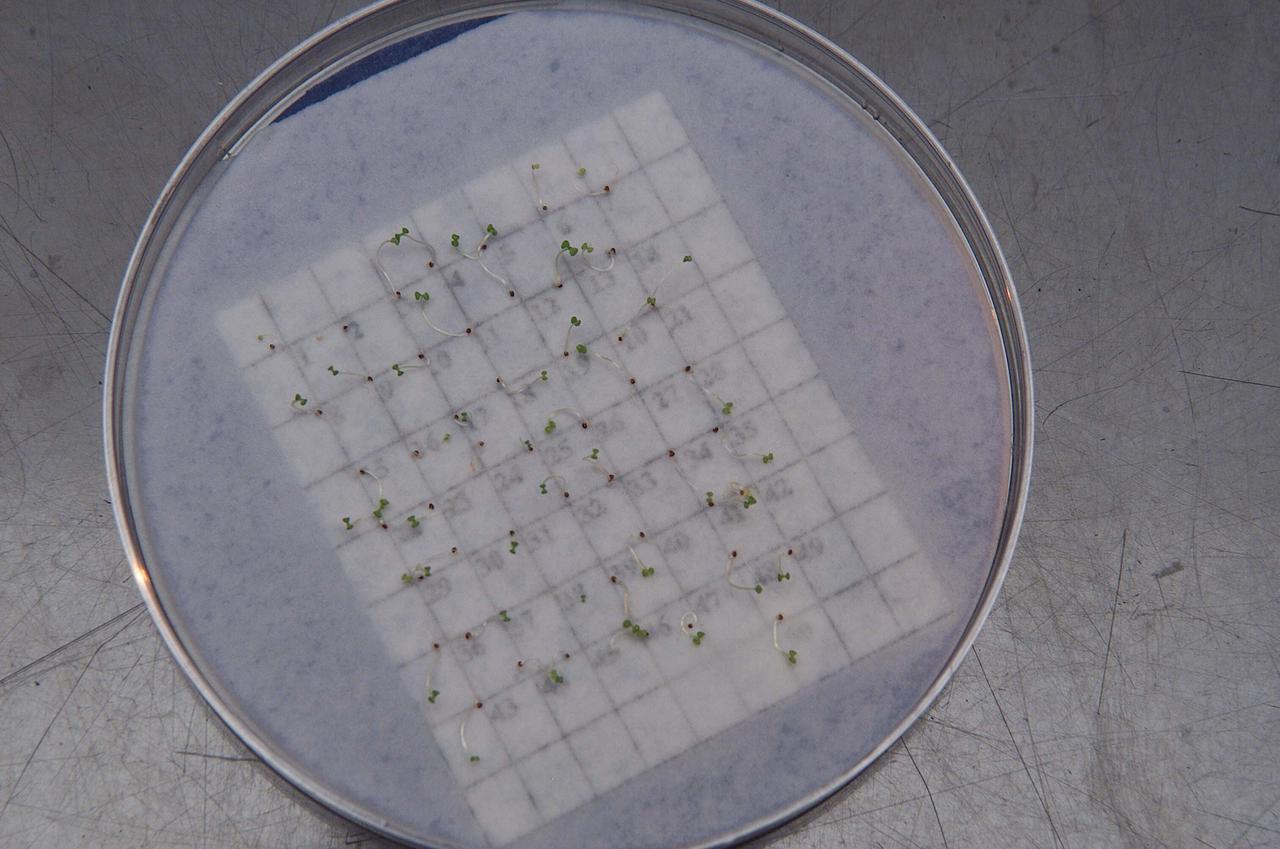
ISS040-E-007672 (5 June 2014) --- One of the Expedition 40 crew members on the International Space Station photographed his hand working with the Vegetable Production System (Veggie) recently added to the orbital outpost. The experiment deals with the growth and development of ‘Outredgeous’ Lettuce (Lactuca sativa) seedlings in the spaceflight environment and the effects of the spaceflight environment on composition of microbial flora on the Veggie-grown plants and the Veggie facility. The purple light is the wavelength that is supposed to best promote photosynthesis and growth for the plants.

KENNEDY SPACE CENTER, FLA. - In the KSC Space Life Sciences Lab, Arabidopsis plants appear purple under red and green light as part of research on growth under various light conditions. Other plant research includes different CO2 concentrations and temperatures. The Lab is exploring various aspects of a bioregenerative life support system. Such research and technology development will be crucial to long-term habitation of space by humans.

The early-morning Sun bathes the Space Shuttle Discovery in hues of purple, pink and gold as it is encased in the Mate-Demate Device (MDD) at NASA’s Dryden Flight Research Center at Edwards, California. The gantry-like MDD structure is used to prepare the shuttle for its ferry flight back to the Kennedy space Center in Florida, including mounting the shuttle atop NASA’s modified Boeing 747 Shuttle Carrier Aircraft.
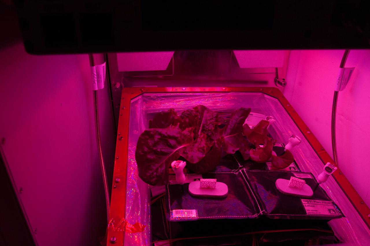
ISS040-E-007676 (5 June 2014) --- One of the Expedition 40 crew members on the International Space Station took a series of photos of the Vegetable Production System (Veggie) recently added to the orbital outpost. The experiment deals with the growth and development of ‘Outredgeous’ Lettuce (Lactuca sativa) seedlings in the spaceflight environment and the effects of the spaceflight environment on composition of microbial flora on the Veggie-grown plants and the Veggie facility. The purple light is the wavelength that is supposed to best promote photosynthesis and growth for the plants.
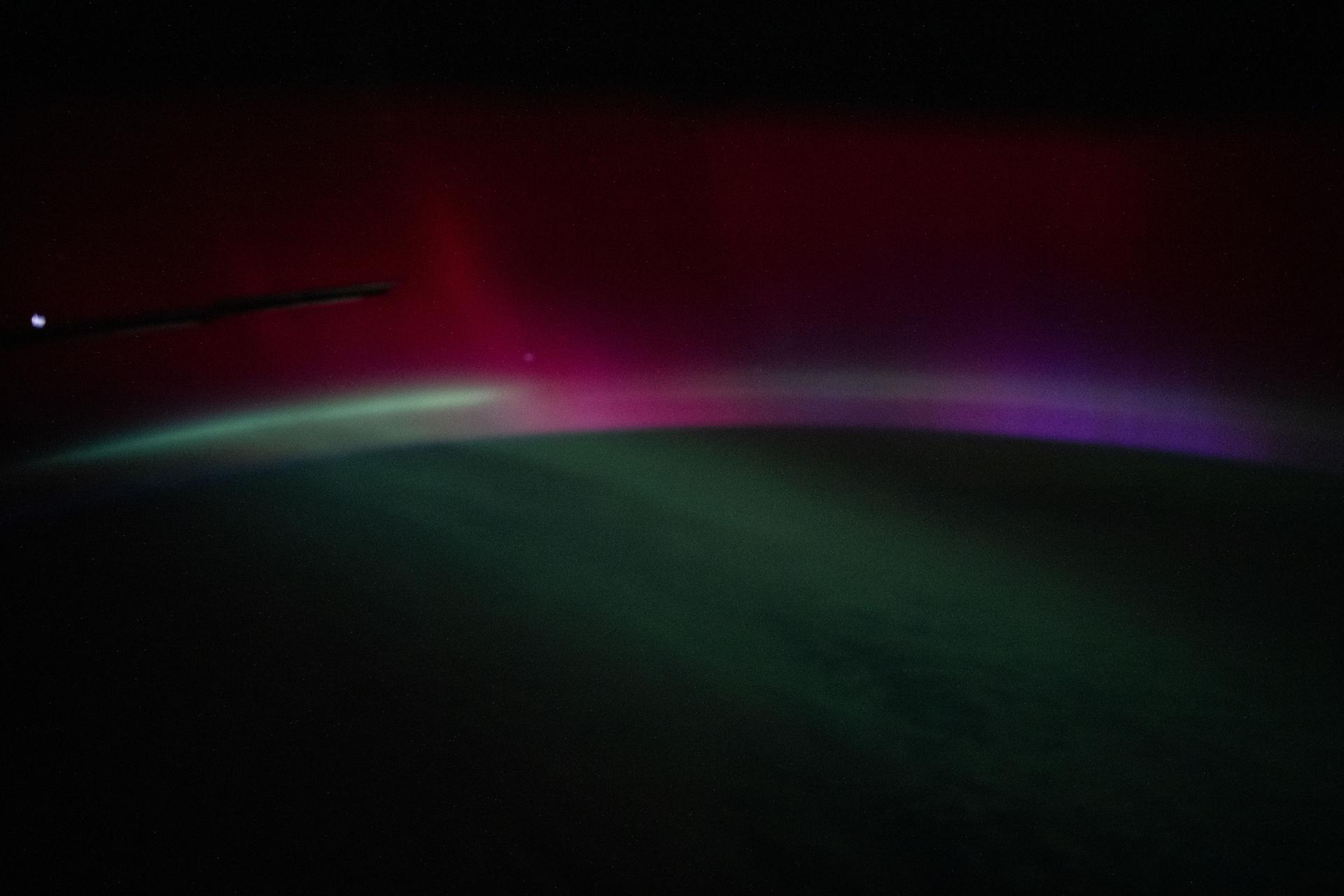
iss074e0150531 (Jan. 19, 2026) --- A wispy, multi-colored aurora—created by a geomagnetic storm and producing rare colors such as deep red and purple—is pictured above the Atlantic Ocean. The International Space Station was orbiting 262 miles above Earth off the coast of Portugal at approximately 10:31 p.m. local time when this photograph was taken.

ISS045E048653 (10/06/2015) --- The International Space Station crew witness nightly scenes of our Earths beauty after performing their duties. Here on Oct. 6, 2015, framed by the edge of a huge Station solar panel, the city of Moscow Russia sparkles in the night with spoke streets streaming out across the land while an aurora of blue white and purple contrast the star filled sky.
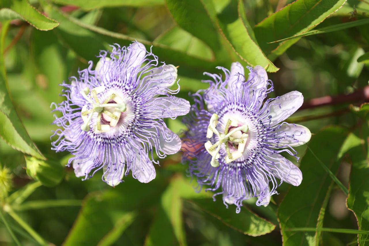
A close-up view of wildflowers called Passiflora incarnata (purple passionflower) in a field at NASA’s Kennedy Space Center in Florida on June 13, 2023. The center shares a boundary with the Merritt Island National Wildlife Refuge. Along with wildflowers, Kennedy and the wildlife refuge are home to more than 300 native and migratory bird species, 65 amphibian and reptile species, and more than 1,000 different types of plants.
At 11:29 p.m. PDT on Oct. 6 (2:29 a.m. EDT on Oct. 7), NASA's Atmospheric Infrared Sounder (AIRS) instrument on NASA's Aqua satellite produced this false-color infrared image of Matthew as the storm moved up Florida's central coast. The image shows the temperature of Matthew's cloud tops or the surface of Earth in cloud-free regions, with the most intense thunderstorms shown in purples and blues. http://photojournal.jpl.nasa.gov/catalog/PIA21097
These images show the sudden appearance of a bright aurora on Mars during a solar storm in September 2017. The purple-white color scheme shows the intensity of ultraviolet light seen on Mars' night side before (left) and during (right) the event. A simulated image of Mars for the same time and orientation has been added, with the dayside crescent visible on the right. The auroral emission appears brightest at the edges of the planet where the line of sight passes along the length of the glowing atmosphere layer. The data are from observations by the Imaging Ultraviolet Spectrograph instrument (IUVS) on NASA's Mars Atmosphere and Volatile Evolution orbiter, or MAVEN. Note that, unlike auroras on Earth, the Martian aurora is not concentrated at the planet's polar regions. This is because Mars has no strong magnetic field like Earth's to concentrate the aurora near the poles. https://photojournal.jpl.nasa.gov/catalog/PIA21855
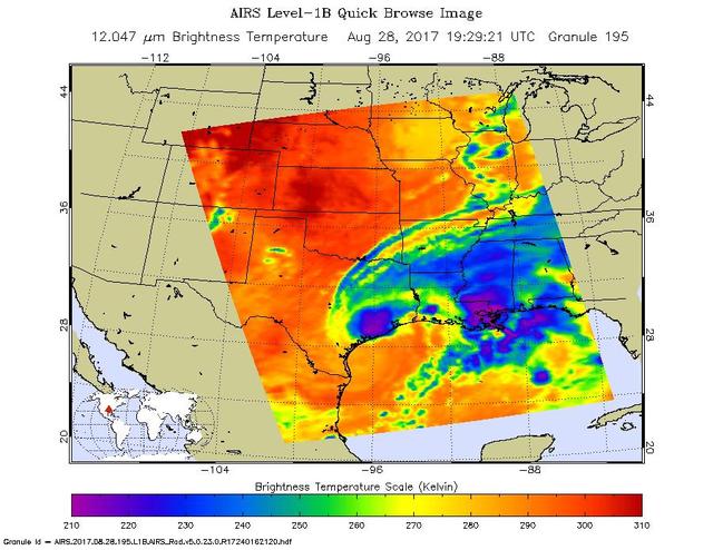
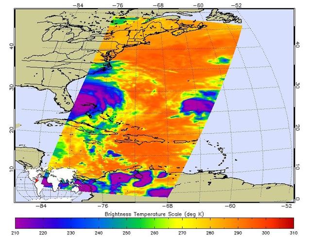
The latest infrared image from NASA's Atmospheric Infrared Sounder (AIRS) instrument aboard NASA's Aqua satellite illustrates the growing flood threat from now Tropical Storm Harvey. In the false-color image, acquired at 2:29 p.m. CDT (19:29 UTC) on Aug. 28, 2017, a large area of dark blue and purple centered along the southeastern Texas coast denotes the coldest cloud top temperatures and strongest thunderstorms. A second area of intense precipitation is visible over southeastern Louisiana. Harvey has reemerged over the Gulf of Mexico, but the National Hurricane Center forecasts only a small amount of strengthening before the storm moves slowly north and inland again. https://photojournal.jpl.nasa.gov/catalog/PIA21885

Some climate forecast models indicate there is an above average chance that there could be a weak to borderline El Niño by the end of November 2003. However, the trade winds, blowing from east to west across the equatorial Pacific Ocean, remain strong. Thus, there remains some uncertainty among climate scientists as to whether the warm temperature anomaly will form again this year. The latest remote sensing data from NASA's Jason satellite show near normal conditions across the equatorial Pacific. There are currently no visible signs in sea surface height of an impending El Niño. This equatorial quiet contrasts with the Bering Sea, Gulf of Alaska and U.S. West Coast where lower-than-normal sea surface levels and cool ocean temperatures continue (indicated by blue and purple areas). The image above is a global map of sea surface height, accurate to within 30 millimeters. The image represents data collected and composited over a 10-day period, ending on Nov. 3, 2003. The height of the water relates to the temperature of the water. As the ocean warms, its level rises; and as it cools, its level falls. Yellow and red areas indicate where the waters are relatively warmer and have expanded above sea level, green indicates near normal sea level, and blue and purple areas show where the waters are relatively colder and the surface is lower than sea level. The blue areas are between 5 and 13 centimeters (2 and 5 inches) below normal, whereas the purple areas range from 14 to 18 centimeters (6 to 7 inches) below normal. http://photojournal.jpl.nasa.gov/catalog/PIA04878
This false-color infrared image was taken by the camera system on the Mars Odyssey spacecraft over part of Ganges Chasma in Valles Marineris (approximately 13 degrees S, 318 degrees E). The infrared image has been draped over topography data obtained by Mars Global Surveyor. The color differences in this image show compositional variations in the rocks exposed in the wall and floor of Ganges (blue and purple) and in the dust and sand on the rim of the canyon (red and orange). The floor of Ganges is covered by rocks and sand composed of basaltic lava that are shown in blue. A layer that is rich in the mineral olivine can be seen as a band of purple in the walls on both sides of the canyon, and is exposed as an eroded layer surrounding a knob on the floor. Olivine is easily destroyed by liquid water, so its presence in these ancient rocks suggests that this region of Mars has been very dry for a very long time. The mosaic was constructed using infrared bands 5, 7, and 8, and covers an area approximately 150 kilometers (90 miles) on each side. This simulated view is toward the north. http://photojournal.jpl.nasa.gov/catalog/PIA04262

These images of the Saline Valley area, California, were acquired March 30, 2000 and cover a full ASTER scene (60 by 60 km). Each image displays data from a different spectral region, and illustrates the complementary nature of surface compositional information available as a function of wavelength. This image displays visible and near infrared bands 3, 2, and 1 in red, green, and blue (RGB). Vegetation appears red, snow and dry salt lakes are white, and exposed rocks are brown, gray, yellow and blue. Rock colors mainly reflect the presence of iron minerals, and variations in albedo. Figure 1 displays short wavelength infrared bands 4, 6, and 8 as RGB. In this wavelength region, clay, carbonate, and sulfate minerals have diagnostic absorption features, resulting in distinct colors on the image. For example, limestones are yellow-green, and purple areas are kaolinite-rich. Figure 2 displays thermal infrared bands 13, 12 and 10 as RGB. In this wavelength region, variations in quartz content appear as more or less red; carbonate rocks are green, and mafic volcanic rocks are purple. The image is located at 36.8 degrees north latitude and 117.7 degrees west longitude. http://photojournal.jpl.nasa.gov/catalog/PIA11164
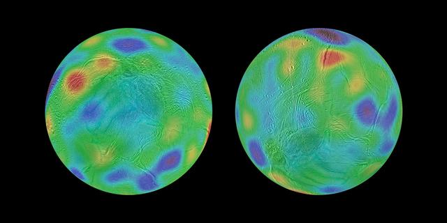
Working with image data from NASA's Cassini mission, researchers have found evidence that Saturn's moon Enceladus may have tipped over, reorienting itself so that terrain closer to its original equator was relocated to the poles. This phenomenon is known as true polar wander. Researchers discovered a chain of basins across the surface of Enceladus along with a pair of depressions that line up with an equator and poles, respectively, if the moon's axis of rotation was reoriented by about 55 degrees of latitude. These maps look toward the icy moon's southern hemisphere, with colors representing highs and lows. Purple represents the lowest elevations, while red represents the highest. The map at left shows the surface of Enceladus in its possible ancient orientation, millions of years ago. The chain of basins representing topographic lows can be seen in blue and purple, running along the equator, with an additional low region around the original south pole. The region that encloses the moon's currently active south polar terrain, with its long, linear "tiger stripe" fractures, would have been at middle latitudes just south of the equator. The map at right shows the current orientation of Enceladus. https://photojournal.jpl.nasa.gov/catalog/PIA21612
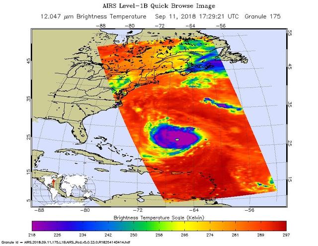
This image, taken at 1:35 pm local time on Tuesday, September 11, 2018 by the Atmospheric Infrared Sounder (AIRS) onboard NASA's Aqua satellite shows Hurricane Florence whose strong winds are expected to reach the Carolina coast late Thursday. Florence intensified from a Category 2 to a Category 4 storm in a matter of hours. As of Tuesday evening, Florence had maximum sustained winds of 140 mph (225 kph). AIRS has more than 2,000 "channels" that capture various hues of infrared, and this image represents the temperature of the cloud tops and the ocean surface (called "brightness temperature" in the image). Purple shows very cold clouds high in the atmosphere, blue and green show the warmer temperatures of lower clouds, and red shows the surface. Florence has the characteristics of a mature, powerful hurricane: an extensive, nearly symmetric ring of deep, cold rain clouds in purple; slightly shallower rain clouds in the outer perimeter seen in green; a large area of cloud-free air flowing away from the storm in red; and a well-defined eye (seen as the greenish spot near the center) where warm low clouds can be seen below. https://photojournal.jpl.nasa.gov/catalog/PIA22697
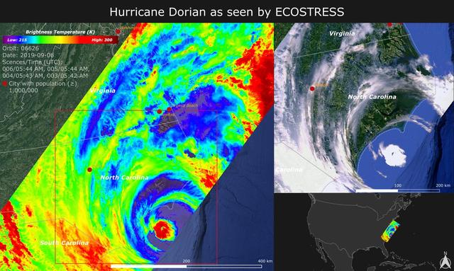
NASA's ECOsystem Spaceborne Thermal Radiometer Experiment on Space Station (ECOSTRESS) imaged the temperature of Hurricane Dorian from the International Space Station on Sept. 6, 2019 as the storm made landfall in North Carolina. ECOSTRESS senses the amount of emitted infrared radiation from Earth, which is converted into an equivalent temperature scale in units of degrees Kelvin. In the image, red colors such as the well-defined eye represent warmer temperatures while purple/blue represent the cooler cloud top temperatures of strong storm clouds with the potential of producing heavy rain. The temperature patterns reveal fine cloud structures that contribute to the formation of the larger hurricane. The width of the image (~400 km) is based on what ECOSTRESS sees as the Space Station flies over any given spot on Earth. ECOSTRESS launched to the space station in June 2018. It can measure variations in temperature to within a few tenths of a degree and is able to detect temperature changes at various times of day over areas as small as a football field. ECOSTRESS' primary mission is to detect plant health from space; however, its measurements can be used to detect other heat-related phenomena — including urban heat, fires, and volcanic activity — as well. Although disaster response is not one of its primary objectives, these highly detailed hurricane temperature estimates can be used to improve weather models. https://photojournal.jpl.nasa.gov/catalog/PIA23422

This view shows Mercury's north polar region, colored by the maximum biannual surface temperature, which ranges from >400 K (red) to 50 K (purple). As expected for the Solar System's innermost planet, areas of Mercury's surface that are sunlit reach high temperatures, and hence most of this image is colored red! In contrast, some craters near Mercury's poles have regions that remain permanently in shadow, and in these regions even the maximum temperatures can be extremely low. Evidence from MESSENGER and Earth-based observations indicate that water ice deposits are present in these cold craters. The craters nearest Mercury' poles have surface temperatures less than 100 K (-173°C, -280°F), and water ice is stable on the surface, such as in Prokofiev. However, many craters near but somewhat farther from Mercury's poles have cold, permanently shadowed interiors, but the maximum temperature is too high for water ice to persist at the surface. In these craters, water ice is present but is buried beneath a thin, low-reflectance volatile layer likely consisting of organic-rich material, such as in Berlioz crater. http://photojournal.jpl.nasa.gov/catalog/PIA19247
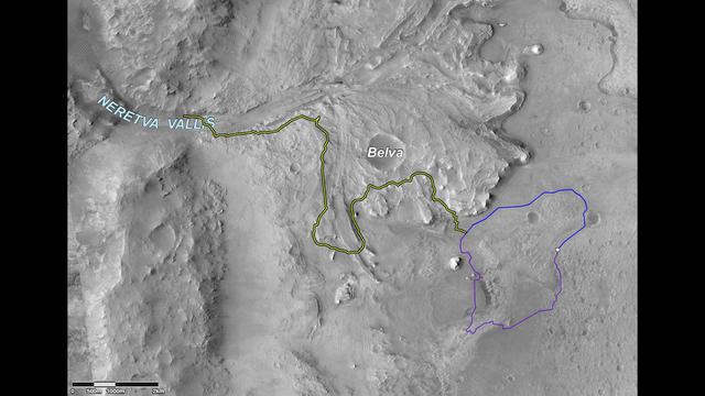
This image shows two possible routes (blue and purple) to the fan-shaped deposit of sediments known as a delta for NASA's Perseverance rover, which landed at the spot marked with a white dot in Mars' Jezero Crater. The yellow line marks a notional traverse exploring the delta. The base image is from the High Resolution Imaging Experiment (HiRISE) camera aboard NASA's Mars Reconnaissance Orbiter (MRO). MRO's mission is managed by NASA's Jet Propulsion Laboratory, a division of Caltech in Pasadena, California, for NASA's Science Mission Directorate. Lockheed Martin Space in Denver built the spacecraft. The University of Arizona in Tucson provided and operates HiRISE. A key objective for Perseverance's mission on Mars is astrobiology, including the search for signs of ancient microbial life. The rover will characterize the planet's geology and past climate, pave the way for human exploration of the Red Planet, and be the first mission to collect and cache Martian rock and regolith (broken rock and dust). Subsequent NASA missions, in cooperation with ESA (European Space Agency), would send spacecraft to Mars to collect these sealed samples from the surface and return them to Earth for in-depth analysis. The Mars 2020 Perseverance mission is part of NASA's Moon to Mars exploration approach, which includes Artemis missions to the Moon that will help prepare for human exploration of the Red Planet. https://photojournal.jpl.nasa.gov/catalog/PIA24486
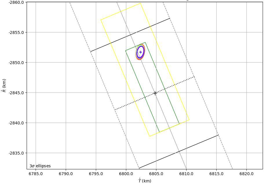
This graphic shows the B-Plane for NASA's Mars 2020 Perseverance rover mission as of February 15, 2021. A B-Plane is a key performance metric that navigators for interplanetary missions use to determine the accuracy of their spacecraft's trajectory. The entry target on the lower right of the image (black cross) depicts the point where mission navigators are targeting the Mars 2020 spacecraft to enter the Red Planet's atmosphere. Higher up, the red, orange, green, and blue ovals depict the estimated "entry uncertainty ellipse" for the spacecraft as determined by previous navigation solutions. The inner-most ring (purple) depicts the most recent trajectory path. https://photojournal.jpl.nasa.gov/catalog/PIA24296

True-color (left) and false-color (right) mosaics of Jupiter's northern hemisphere between 10 and 50 degrees latitude. Jupiter's atmospheric motions are controlled by alternating eastward and westward bands of air between Jupiter's equator and polar regions. The direction and speed of these bands influences the color and texture of the clouds seen in this mosaic. The high and thin clouds are represented by light blue, deep clouds are reddish, and high and thick clouds are white. A high haze overlying a clear, deep atmosphere is represented by dark purple. This image was taken by NASA's Galileo spacecraft on April 3, 1997 at a distance of 1.4 million kilometers (.86 million miles). http://photojournal.jpl.nasa.gov/catalog/PIA03000
This infrared image shows Typhoon Ioke in the Western Pacific, from the Atmospheric Infrared Sounder AIRS on NASA Aqua satellite in August, 2006. Because infrared radiation does not penetrate through clouds, AIRS infrared images show either the temperature of the cloud tops or the surface of the Earth in cloud-free regions. The lowest temperatures (in purple) are associated with high, cold cloud tops that make up the top of the storm. In cloud-free areas the AIRS instrument will receive the infrared radiation from the surface of the Earth, resulting in the warmest temperatures (orange/red). http://photojournal.jpl.nasa.gov/catalog/PIA00511
This infrared image shows Tropical Storm Ernesto over Cuba, from the Atmospheric Infrared Sounder AIRS on NASA Aqua satellite in August, 2006. Because infrared radiation does not penetrate through clouds, AIRS infrared images show either the temperature of the cloud tops or the surface of the Earth in cloud-free regions. The lowest temperatures (in purple) are associated with high, cold cloud tops that make up the top of the storm. In cloud-free areas the AIRS instrument will receive the infrared radiation from the surface of the Earth, resulting in the warmest temperatures (orange/red). http://photojournal.jpl.nasa.gov/catalog/PIA00510
Multiple images from the Mars Color Imager (MARCI) aboard NASA's Mars Reconnaissance Orbiter (MRO) were used to generate this view of a regional dust storm obscuring Syrtis Major and Jezero Crater (white circle). The images were acquired on Jan. 9, 2022. MRO creates global maps of Mars but roll maneuvers for targeted observations produce gaps in the coverage, which appear as black gores in the maps. On some days there are data drops where partial or full orbits of coverage are missing. Green and purple observed in the south polar region indicate saturated pixels. https://photojournal.jpl.nasa.gov/catalog/PIA25068
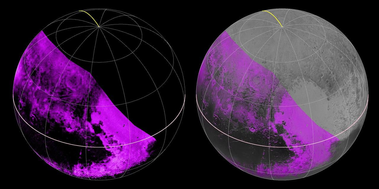
The Ralph/LEISA infrared spectrometer on NASA's New Horizons spacecraft mapped compositions across Pluto's surface as it flew past the planet on July 14, 2015. On the left, a map of methane ice abundance shows striking regional differences, with stronger methane absorption indicated by the brighter purple colors, and lower abundances shown in black. Data have only been received so far for the left half of Pluto's disk. At right, the methane map is merged with higher-resolution images from the spacecraft's Long Range Reconnaissance Imager (LORRI). http://photojournal.jpl.nasa.gov/catalog/PIA19953

This color-infrared image shows sand dunes in Melas Chasma, located within the Valles Marineris canyon system. The dark-blue and purple colors indicate coarse-grained sands that are comprised of basalt, an iron and magnesium-rich volcanic rock that formed from cooled lava millions of years ago when volcanism was an active process on Mars. Migrating sand dunes often lead to the erosion and excavation of underlying material; regions where there are active dune fields are ideal places to search for exposed bedrock. Repeated imaging of dunes may also show changes that provide evidence for active surface processes related to wind patterns and climate. More information is available at https://photojournal.jpl.nasa.gov/catalog/PIA22783
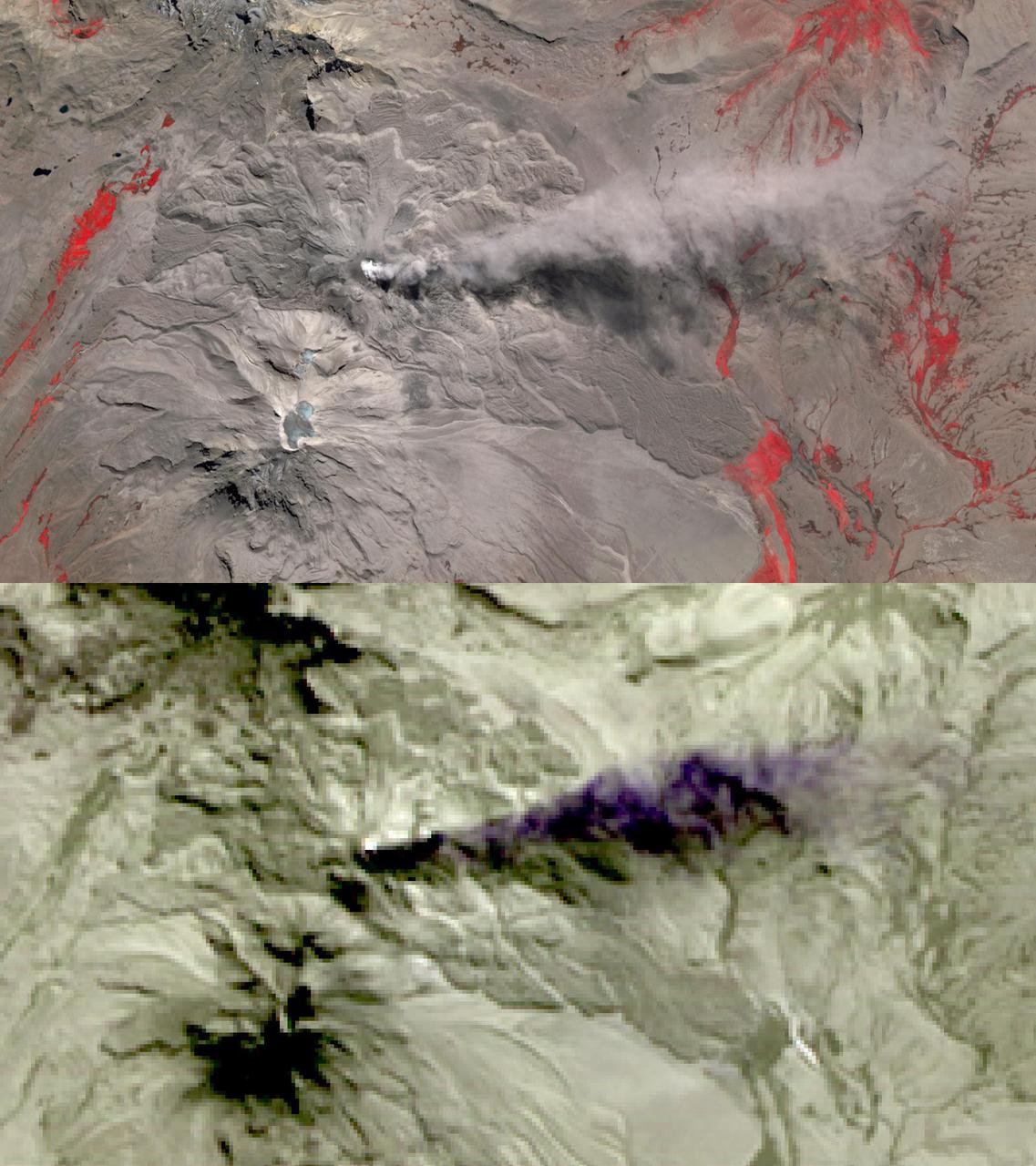
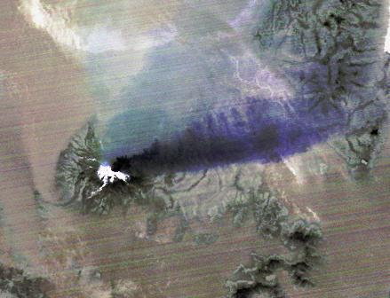
In this image of Peru's Sabancaya stratovolcano, acquired May 13, 2020, the years-long eruption continues. In the top image, Sabancaya has a bright white cloud in its caldera. The greyish cloud to the east is an ash plume. The Ampato volcano, with its prominent summit caldera, is to the south. The red areas are vegetation. The lower thermal infrared composite image shows the plume in purple, indicating that it is dominantly composed of ash and water vapor. A bright hotspot can be seen in the summit caldera of Sabancaya. The images cover an area of 13.5 by 24 kilometers, and are located at 15.8 degrees south, 71.9 degrees west. https://photojournal.jpl.nasa.gov/catalog/PIA24866

ISS033-E-009153 (2 Oct. 2012) --- Japan Aerospace Exploration Agency astronaut Aki Hoshide, Expedition 33 flight engineer, performs a removal and replacement of the DKiV water pump and the E-K pre-treat tank with its hose in the Tranquility node of the International Space Station. E-K contains five liters of pre-treat solution, i.e., a mix of H2SO4 (sulfuric acid), CrO3 (chromium oxide, for oxidation and purple color) and H2O (water). The pre-treat liquid is mixed with water in the DKiV dispenser and used for toilet flushing.
The April 18, 2015 eruption of Calbuco Volcano in Chile, as seen by NASA Terra spacecraft, led to the evacuation of thousands of citizens near the summit, blanketed nearby towns with a layer of ash, and disrupted air traffic. One week later, on April 26, the Advanced Spaceborne Thermal Emission and Reflection Radiometer (ASTER) instrument on NASA's Terra spacecraft acquired this nighttime thermal infrared image of Calbuco. Hot eruptive material at the summit appears in white (hot), with a purple plume streaming to the right, indicating that it is ash-laden. The image covers an area of 3.1 by 4.1 miles (5 by 6.6 kilometers), and is located at 41.3 degrees south, 72.5 degrees west. http://photojournal.jpl.nasa.gov/catalog/PIA19382

This area, on the western edge of Milankovic Crater on Mars, has a thick deposit of sediment that covers a layer rich in ice. The ice is not obvious unless you look in color. In the red-green-blue images that are close to what the human eye would see, the ice looks bright white, while the surroundings are a rusty red. The ice stands out even more clearly in the infrared-red-blue images where it has a striking bluish-purple tone while the surroundings have a yellowish-grey color. The ice-rich material is most visible when the cliff is oriented east-west and is shielded from the sun as it arcs through the sky to the south. https://photojournal.jpl.nasa.gov/catalog/PIA25088
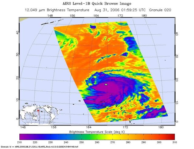
This infrared image shows Tropical Depression 6 Florence in the Atlantic, from the Atmospheric Infrared Sounder AIRS on NASA Aqua satellite in September, 2006. Because infrared radiation does not penetrate through clouds, AIRS infrared images show either the temperature of the cloud tops or the surface of the Earth in cloud-free regions. The lowest temperatures (in purple) are associated with high, cold cloud tops that make up the top of the storm. In cloud-free areas the AIRS instrument will receive the infrared radiation from the surface of the Earth, resulting in the warmest temperatures (orange/red). http://photojournal.jpl.nasa.gov/catalog/PIA00512
This is a radar image of Mount Rainier in Washington state. The volcano last erupted about 150 years ago and numerous large floods and debris flows have originated on its slopes during the last century. Today the volcano is heavily mantled with glaciers and snowfields. More than 100,000 people live on young volcanic mudflows less than 10,000 years old and, consequently, are within the range of future, devastating mudslides. This image was acquired by the Spaceborne Imaging Radar-C and X-band Synthetic Aperture Radar (SIR-C/X-SAR) aboard the space shuttle Endeavour on its 20th orbit on October 1, 1994. The area shown in the image is approximately 59 kilometers by 60 kilometers (36.5 miles by 37 miles). North is toward the top left of the image, which was composed by assigning red and green colors to the L-band, horizontally transmitted and vertically, and the L-band, horizontally transmitted and vertically received. Blue indicates the C-band, horizontally transmitted and vertically received. In addition to highlighting topographic slopes facing the space shuttle, SIR-C records rugged areas as brighter and smooth areas as darker. The scene was illuminated by the shuttle's radar from the northwest so that northwest-facing slopes are brighter and southeast-facing slopes are dark. Forested regions are pale green in color; clear cuts and bare ground are bluish or purple; ice is dark green and white. The round cone at the center of the image is the 14,435-foot (4,399-meter) active volcano, Mount Rainier. On the lower slopes is a zone of rock ridges and rubble (purple to reddish) above coniferous forests (in yellow/green). The western boundary of Mount Rainier National Park is seen as a transition from protected, old-growth forest to heavily logged private land, a mosaic of recent clear cuts (bright purple/blue) and partially regrown timber plantations (pale blue). The prominent river seen curving away from the mountain at the top of the image (to the northwest) is the White River, and the river leaving the mountain at the bottom right of the image (south) is the Nisqually River, which flows out of the Nisqually glacier on the mountain. The river leaving to the left of the mountain is the Carbon River, leading west and north toward heavily populated regions near Tacoma. The dark patch at the top right of the image is Bumping Lake. Other dark areas seen to the right of ridges throughout the image are radar shadow zones. Radar images can be used to study the volcanic structure and the surrounding regions with linear rock boundaries and faults. In addition, the recovery of forested lands from natural disasters and the success of reforestation programs can also be monitored. Ultimately this data may be used to study the advance and retreat of glaciers and other forces of global change. http://photojournal.jpl.nasa.gov/catalog/PIA01727
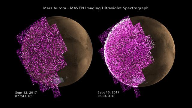
This frame from an animation shows the sudden appearance of a bright aurora on Mars during a solar storm. The purple-white color scheme shows the intensity of ultraviolet light seen on Mars' night side over the course of the event. The data are from observations on Sept. 12 and 13, 2017, by the Imaging Ultraviolet Spectrograph instrument (IUVS) on NASA's Mars Atmosphere and Volatile Evolution orbiter, or MAVEN. The aurora is occurring because energetic particles from the solar storm are bombarding gases in the planet's atmosphere, causing them to glow. A simulated image of the Mars surface for the same time and orientation is also shown, with the dayside crescent visible on the right. The auroral emission appears brightest at the edges of the planet where the line of sight passes along the length of the glowing atmosphere layer. Note that, unlike auroras on Earth, the Martian aurora is not concentrated at the planet's polar regions. This is because Mars has no strong magnetic field like Earth's to concentrate the aurora near the poles. An animation is available at https://photojournal.jpl.nasa.gov/catalog/PIA21854
This set of images from NASA's Mars Reconnaissance Orbiter (MRO) shows a fierce, giant dust storm is kicking up on Mars, with rovers on the surface indicated as icons. The spread of the storm can be seen in the salmon-colored overlay. These images from MRO's Mars Color Imager start from May 31, when the dust event was first detected, and go through June 11, 2018. MRO creates global maps of Mars but roll maneuvers for targeted observations produce gaps in the coverage, which appear as black gores in the maps. On some days there are data drops where partial or full orbits of coverage are missing. Green and purple observed in the south polar region indicate saturated pixels. Latitude is indicated along the vertical axis. Longitude is indicated along the horizontal axis. https://photojournal.jpl.nasa.gov/catalog/PIA22519
Information from images of Railroad Valley, Nevada captured on August 17, 2001 by the Advanced Spaceborne Thermal Emission and Reflection Radiometer (ASTER) may provide a powerful tool for monitoring crop health and maintenance procedures. These images cover an area of north central Nevada. The top image shows irrigated fields, with healthy vegetation in red. The middle image highlights the amount of vegetation. The color code shows highest vegetation content in red, orange, yellow, green, blue, and purple and the lowest in black. The final image is a thermal infrared channel, with warmer temperatures in white and colder in black. In the thermal image, the northernmost and westernmost fields are markedly colder on their northwest areas, even though no differences are seen in the visible image or the second, Vegetation Index image. This can be attributed to the presence of excess water, which can lead to crop damage. http://photojournal.jpl.nasa.gov/catalog/PIA03463