
Several projects supporting NASA's Advanced Air Mobility, or AAM mission, are working on different elements to help make AAM a reality. In order for these new AAM aircraft to safely operate, new infrastructure and changes to current infrastructure will need to be developed in cities, suburbs, and rural areas.
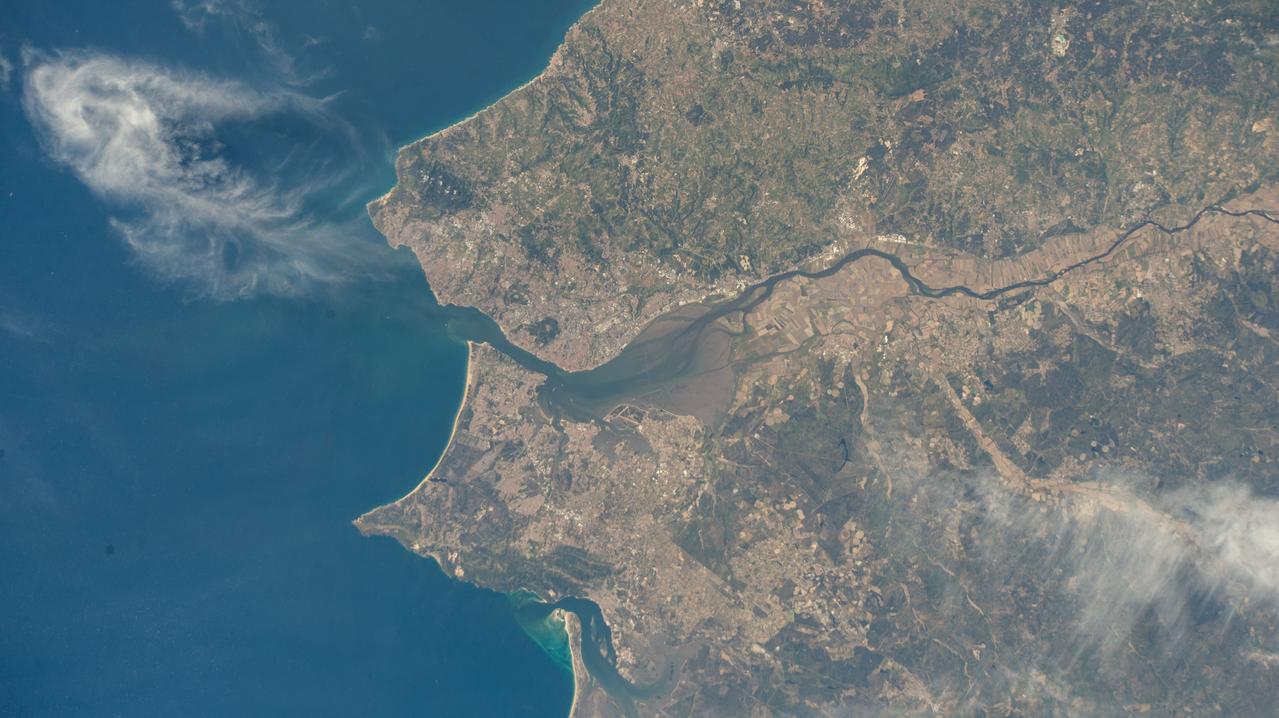
iss073e0078399 (May 22, 2025) --- Lisbon, the capital and largest city of Portugal, and its suburbs on the River Tagus that leads into the Atlantic Ocean are pictured from the International Space Station as it orbited 261 miles above the nation's coast on the Iberian Peninsula.
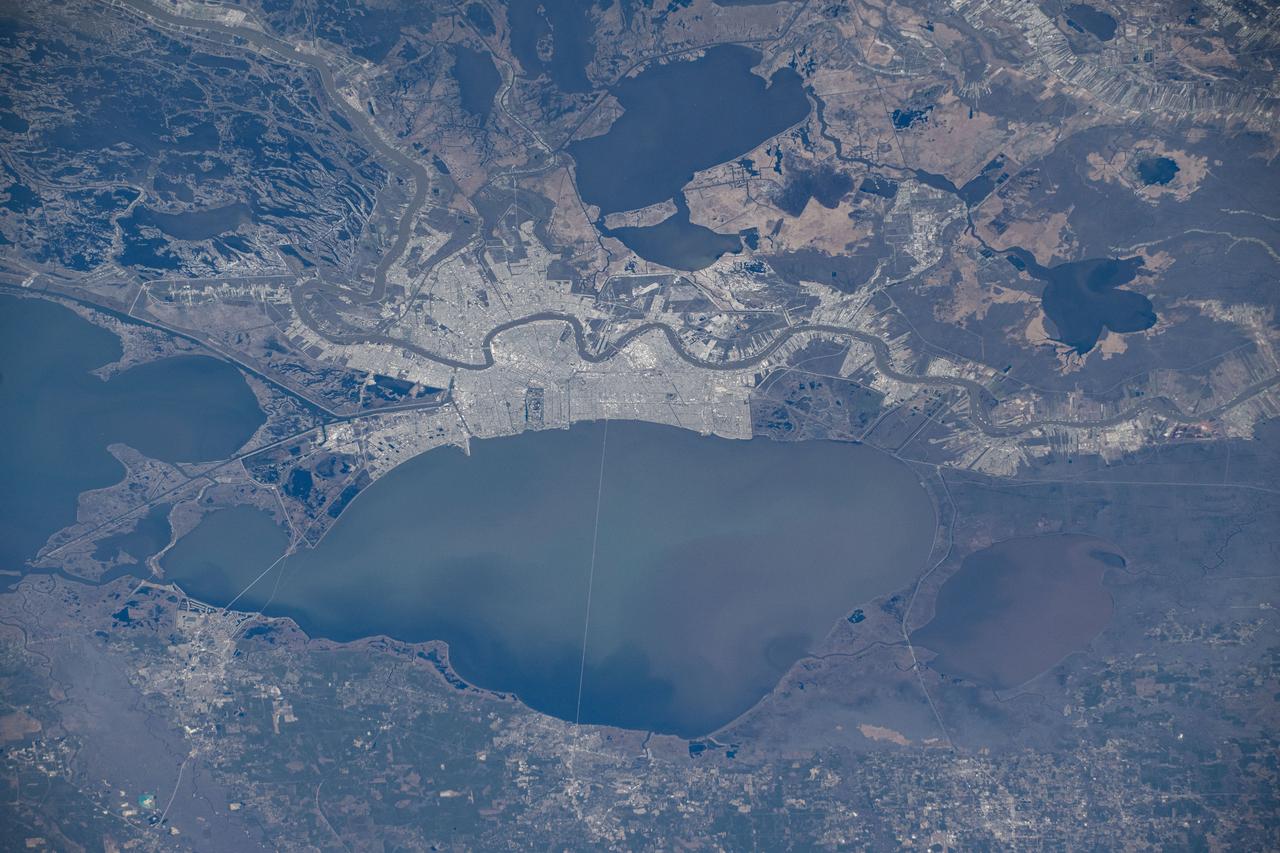
iss072e575658 (Jan. 24, 2025) --- New Orleans, Louisiana, and its suburbs along the Mississippi River and on the shoreline of Lake Pontchartrain are pictured from the International Space Station as it orbited above.
iss072e575684 (Jan. 24, 2025) --- New Orleans, Louisiana, and its suburbs along the Mississippi River and on the shoreline of Lake Pontchartrain are pictured from the International Space Station as it orbited above.
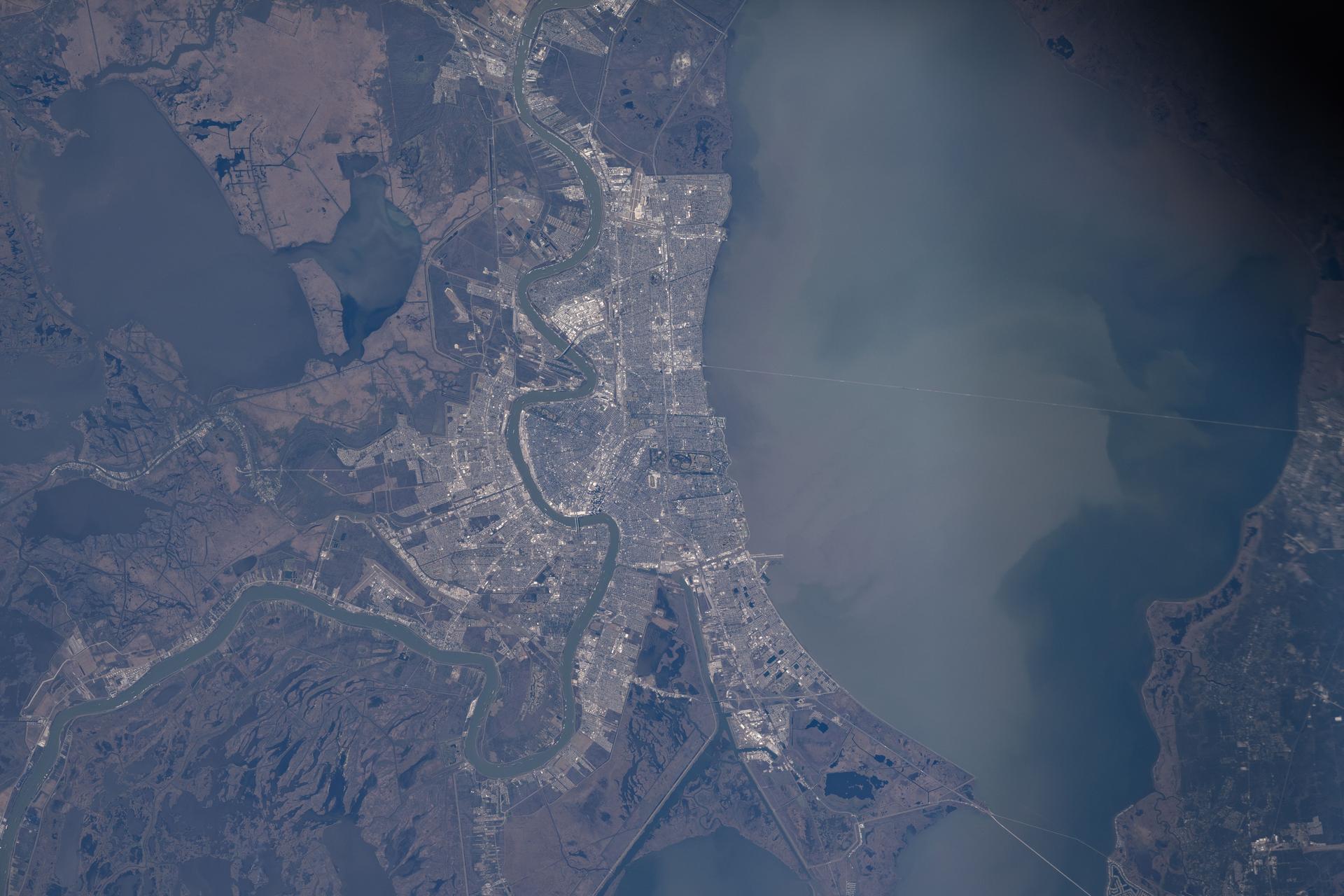
iss074e0150293 (Jan. 19, 2026) --- The Mississippi River winds through New Orleans, Louisiana, and its suburbs on the south shore of Lake Pontchartrain in this photograph taken from the International Space Station as it orbited 258 miles above Earth.
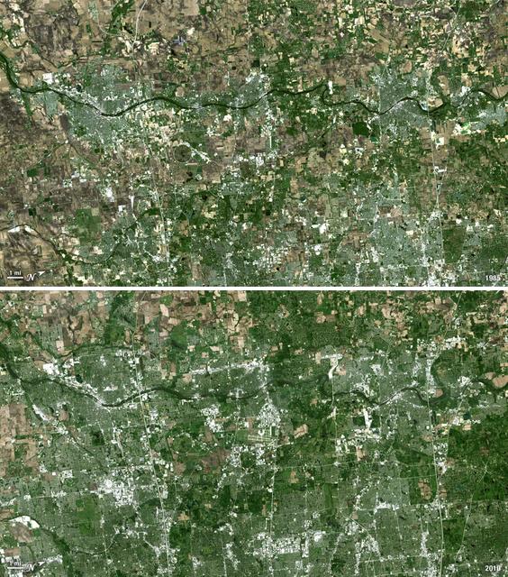
Forty miles west of downtown Chicago, the Fox River meanders its way through what has become the westernmost reaches of metropolitan Chicago, where the sprawling metropolis meets the hinterlands. While Chicago itself has seen a seven percent population decline during the last decade, the population of its metropolitan region, "Chicagoland," has steadily increased. These two natural-color Landsat 5 images acquired a quarter-century apart (on May 2, 1985, and May 23, 2010), stand witness to the soaring growth of this region. Aurora, Illinois’ second largest city, is the silvery-green region to the left hugging the Fox River, just south of the I-88 (North is to the right in this image); Carpentersville is found on the rightmost side, north of the I-90. From 1985 to 2010 a development explosion can been seen as the browns of pasture lands give way to silvery-green suburban areas and large white-colored business districts spring up along and east of the river. A major expansion of Dupage Airport appears in the middle of the 2010 image, and the circular-shaped region north of the I-88 and east of the Fox River, visible on both images, is the Department of Energy’s Fermilab. ---- NASA and the U.S. Department of the Interior through the U.S. Geological Survey (USGS) jointly manage Landsat, and the USGS preserves a 40-year archive of Landsat images that is freely available over the Internet. The next Landsat satellite, now known as the Landsat Data Continuity Mission (LDCM) and later to be called Landsat 8, is scheduled for launch in 2013. In honor of Landsat’s 40th anniversary in July 2012, the USGS released the LandsatLook viewer – a quick, simple way to go forward and backward in time, pulling images of anywhere in the world out of the Landsat archive. <b><a href="http://www.nasa.gov/audience/formedia/features/MP_Photo_Guidelines.html" rel="nofollow">NASA image use policy.</a></b> <b><a href="http://www.nasa.gov/centers/goddard/home/index.html" rel="nofollow">NASA Goddard Space Flight Center</a></b> enables NASA’s mission through four scientific endeavors: Earth Science, Heliophysics, Solar System Exploration, and Astrophysics. Goddard plays a leading role in NASA’s accomplishments by contributing compelling scientific knowledge to advance the Agency’s mission. <b>Follow us on <a href="http://twitter.com/NASA_GoddardPix" rel="nofollow">Twitter</a></b> <b>Like us on <a href="http://www.facebook.com/pages/Greenbelt-MD/NASA-Goddard/395013845897?ref=tsd" rel="nofollow">Facebook</a></b> <b>Find us on <a href="http://instagrid.me/nasagoddard/?vm=grid" rel="nofollow">Instagram</a></b>
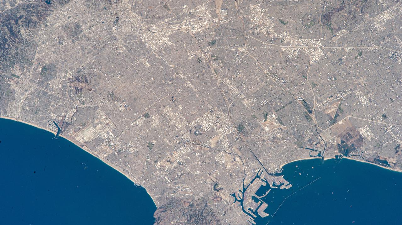
iss073e0513936 (Aug. 22, 2025) --- Los Angeles, California, surrounded by its suburbs including Santa Monica, Marina Del Rey, and Long Beach, is pictured from the International Space Station as it orbited 261 miles above the Golden State. Highlights include Terminal Island (bottom right), an artificial island used mainly for industrial and port-related activities. At left, near Marina Del Rey is Los Angeles International Airport (LAX) connecting over 80 million passengers annually to over 100 domestic and international destinations.
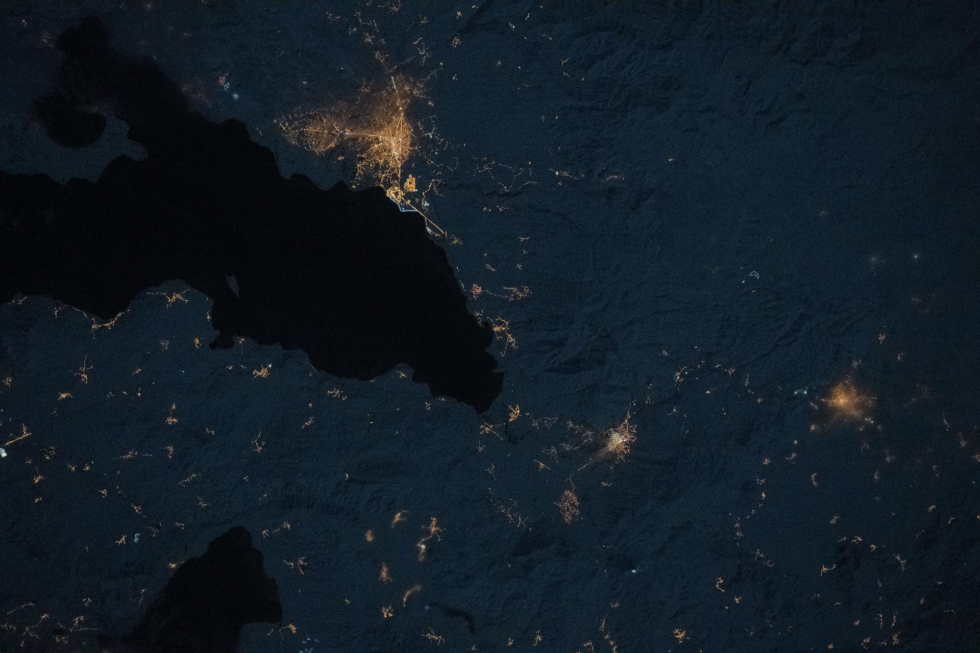
iss073e1047143 (Nov. 2, 2025) --- The city lights of Bari, Italy, and its surrounding suburbs dot the nation's Adriatic Sea coast in this photograph taken from the International Space Station at approximately 10:13 p.m. local time as it orbited 260 miles above the Mediterranean Sea. Founded around 2,700 years ago, Bari is known for its olive groves, vineyards, spectacular caves, and rugged coastal cliffs.
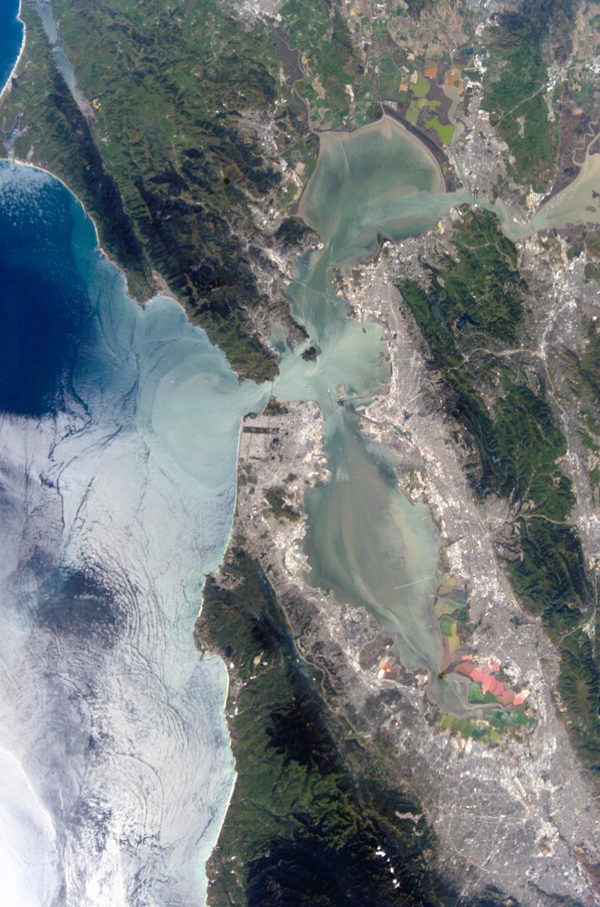
iss073e0285002 (July 4, 2025) --- The city of San Francisco, California, and its suburbs including San Jose and Oakland, surround the San Francisco Bay at approximately midnight local time in this photograph from the International Space Station as it orbited 261 miles above the Golden State.

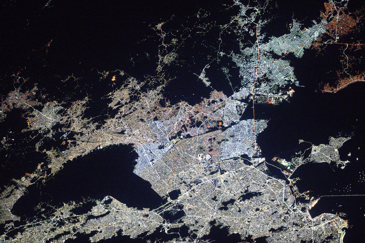
iss073e0088816 (May 16, 2025) --- The International Space Station was soaring 259 miles above central Mexico with a faint atmospheric glow crowning Earth's horizon at approximately 2:58 a.m. local time when this photograph was taken. The city lights of Mexico City, the nation's capital and largest city with a population of 9.21 million, and its surrounding suburbs dominate the nightscape.
iss074e0043930 (Jan. 3, 2026) --- The amber high-pressure sodium lights of Erciş, Türkiye (top), along with its suburbs and villages, dot the landscape surrounding Lake Van in the nation’s Eastern Anatolia Region. The International Space Station was orbiting 262 miles above Earth at approximately 10:12 p.m. local time when this photograph was taken. Credit: JAXA/Kimiya Yui
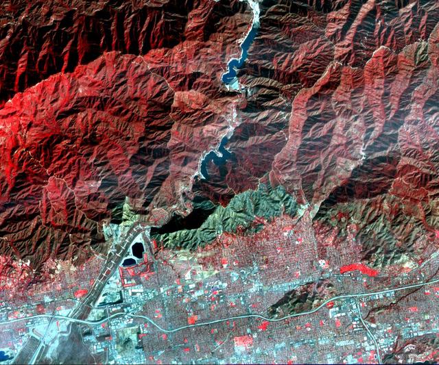
On Jan. 16, 2014, NASA Terra spacecraft acquired this image of a wildfire broke that out in the mountains above the Los Angeles suburbs of Glendora and Azusa.
iss074e0043921 (Jan. 3, 2026) --- The amber high-pressure sodium lights of Van, Türkiye (center), along with its suburbs and villages, dot the southeast coast of Lake Van in the nation’s Eastern Anatolia Region. The International Space Station was orbiting 262 miles above Earth at approximately 10:12 p.m. local time when this photograph was taken. Credit: JAXA/Kimiya Yui
More than 2 million acres were consumed by hundreds of fires between December 2002 and February 2003 in southeastern Australia national parks, forests, foothills and city suburbs as seen by NASA Terra spacecraft.

iss071e056627 (May 6, 2024) --- The city lights of Bangkok,Thailand, and its suburbs contrast with the green lights of the fishing boats on the Gulf of Thailand and the Andaman Sea.
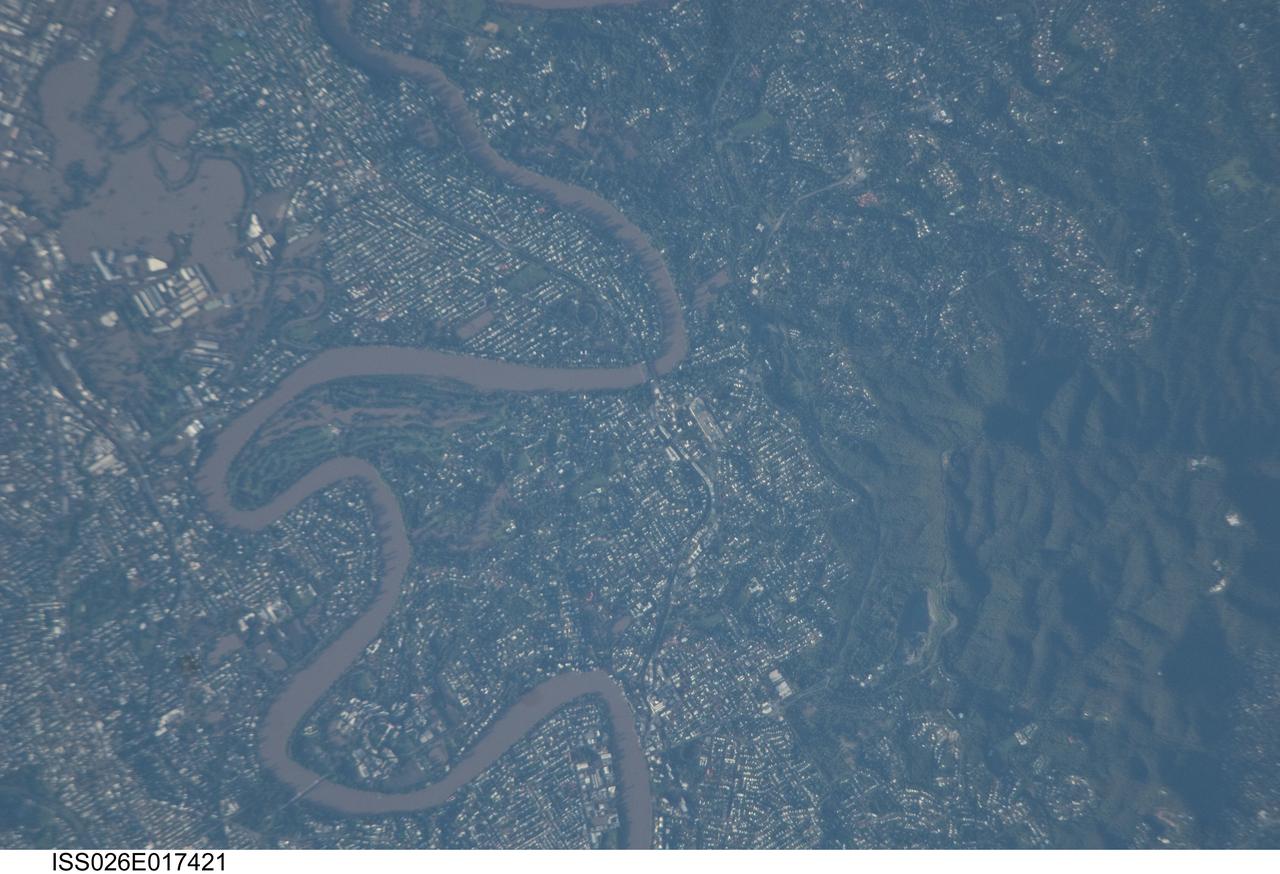
ISS026-E-017421 (13 Jan. 2011) --- Photographed by an Expedition 26 crew member on the International Space Station, this detailed photograph illustrates flooding in suburbs of the Brisbane, Australia metropolitan region. The Brisbane area experienced catastrophic flooding following unusually heavy rainfall on Jan. 10, 2011. With surficial soils already saturated from previous rainfall events, eastward-draining surface flow caused the Brisbane River to flood—inundating an estimated 20,000 homes in suburbs of the capital city of Queensland. Other cities in Queensland have also experienced damaging floods during previous heavy rainfall events this year. The image highlights several suburbs along the Brisbane River in the southern part of the Brisbane metropolitan area. The light-colored rooftops of residences and other structures contrast sharply with green vegetation and brown, sediment laden floodwaters. Most visible low-lying areas are inundated by floodwater, perhaps the most striking being Rocklea at upper left. The suburb of Yeronga (lower left) also has evident regions of flooding, as does a park and golf course located along a bend in the Brisbane River to the south of St. Lucia (center). Flooding becomes less apparent near the higher elevations of Mt. Coot-Tha at right.

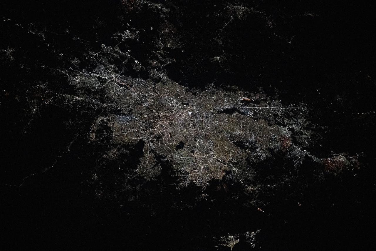
iss071e009150 (April 16, 2024) --- Turin, Italy, and its suburbs (at left) lie at the southwestern foot of the Alps in this photograph from the International Space Station as it orbited 260 miles above Europe.

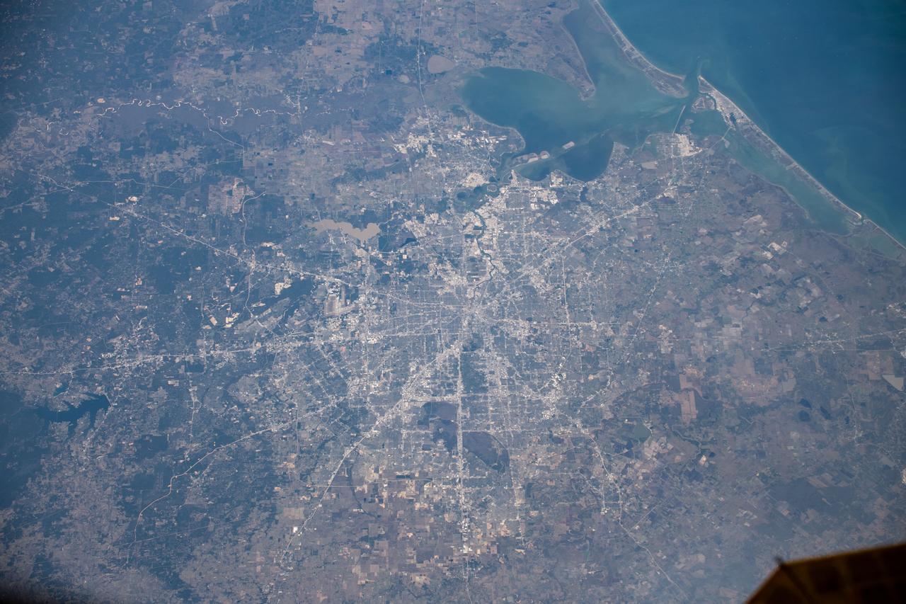
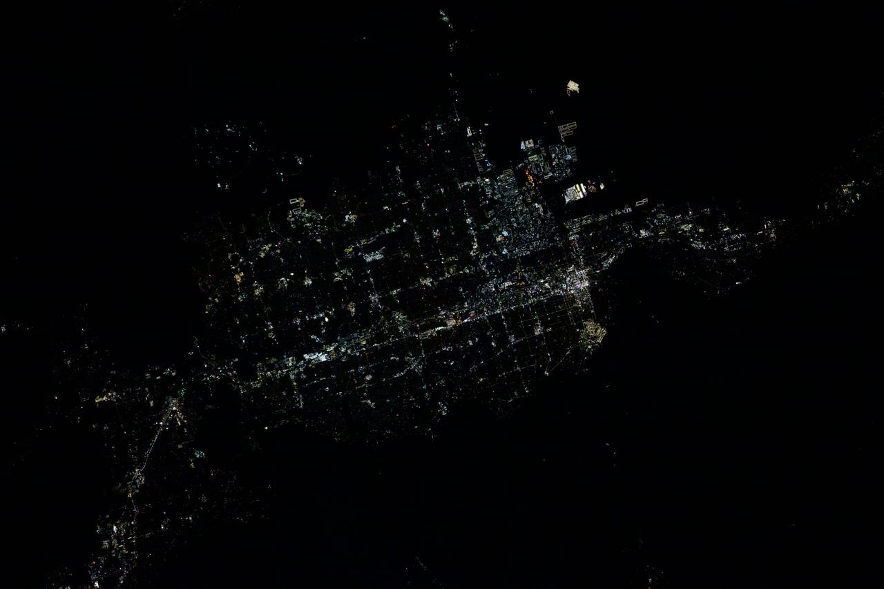
iss071e007521 (April 11, 2024) --- Dallas, Texas, its eastern suburbs, and Lake Ray Hubbard are pictured from the International Space Station as it orbited 260 miles above the Lone Star State.
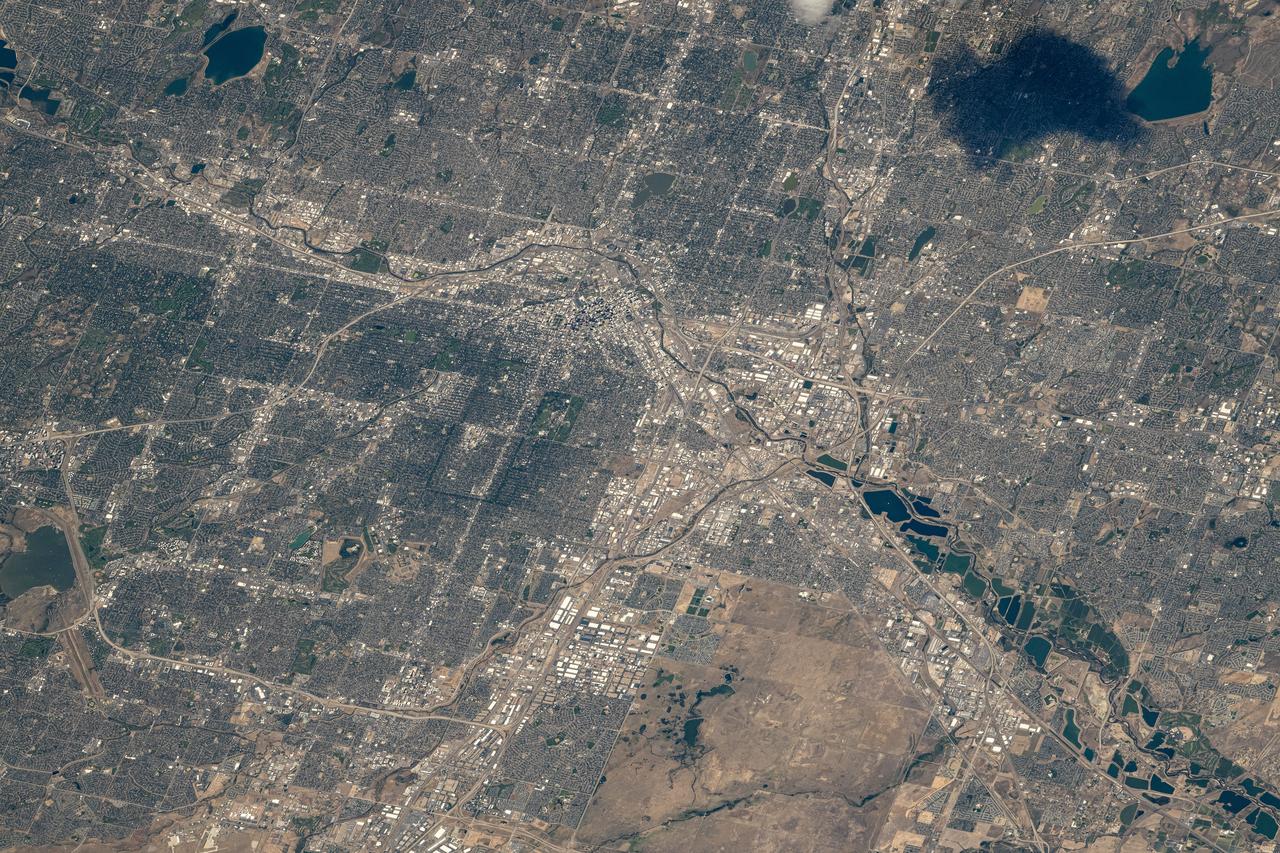
iss071e516877 (Aug. 18, 2024) --- Denver, Colorado, the Centennial State's capital city with a population of over 715,000, and its suburbs along the South Platte River are pictured from the International Space Station as it orbited 260 miles above.
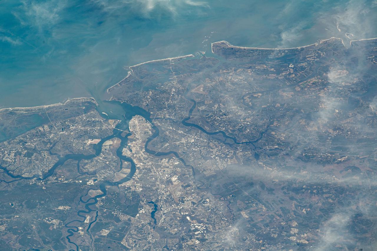
iss070e043540 (Dec. 20, 2023) --- Charleston, South Carolina, and its sourrounding suburbs are split by rivers and creeks emptying into the Atlantic Ocean in this photograph from the International Space Station as it orbited 259 miles above.
iss067e238165 (Aug. 5, 2022) --- Taizhuo, China, and its surrounding suburbs on the East China Sea are pictured from the International Space Station as it orbited 258 miles above the east coast of the Asian nation.
iss061e066680 (Dec. 3, 2019) --- Houston, Texas and its surrounding suburbs, including the island city of Galveston at the entrance of Galveston Bay at top right, is pictured from the International Space Station at an altitude of 257 miles.
iss065e214158 (Aug. 1, 2021) --- New York City and its suburbs light up this portion of the northeastern U.S. coast of the United States in this oblique view view from the International Space Station.
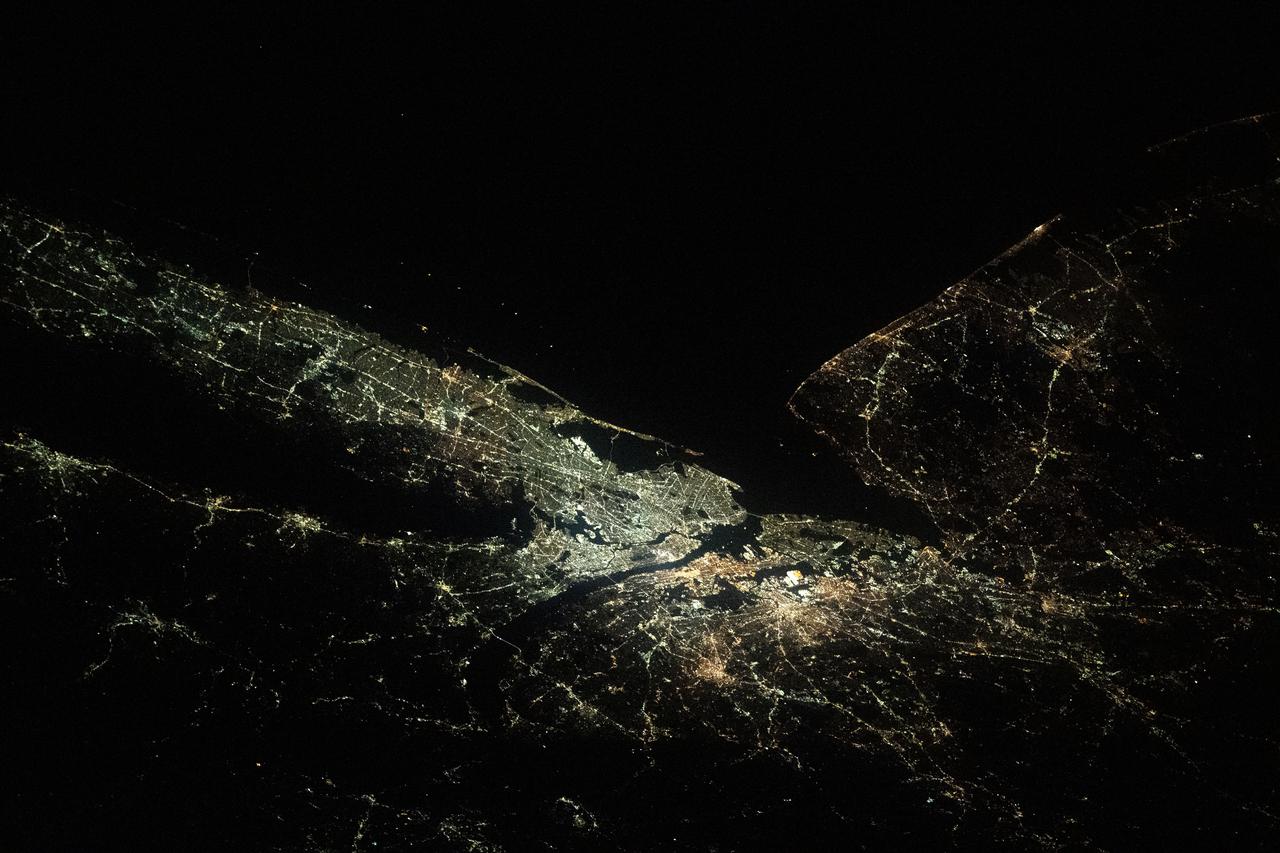
iss063e088344 (Sept. 15, 2020) --- Like two galaxies nearing each other, this nighttime shot from the International Space Station shows the well-lit cities of Washington, D.C. (left), Baltimore, Maryland (right) and their surrounding suburbs.
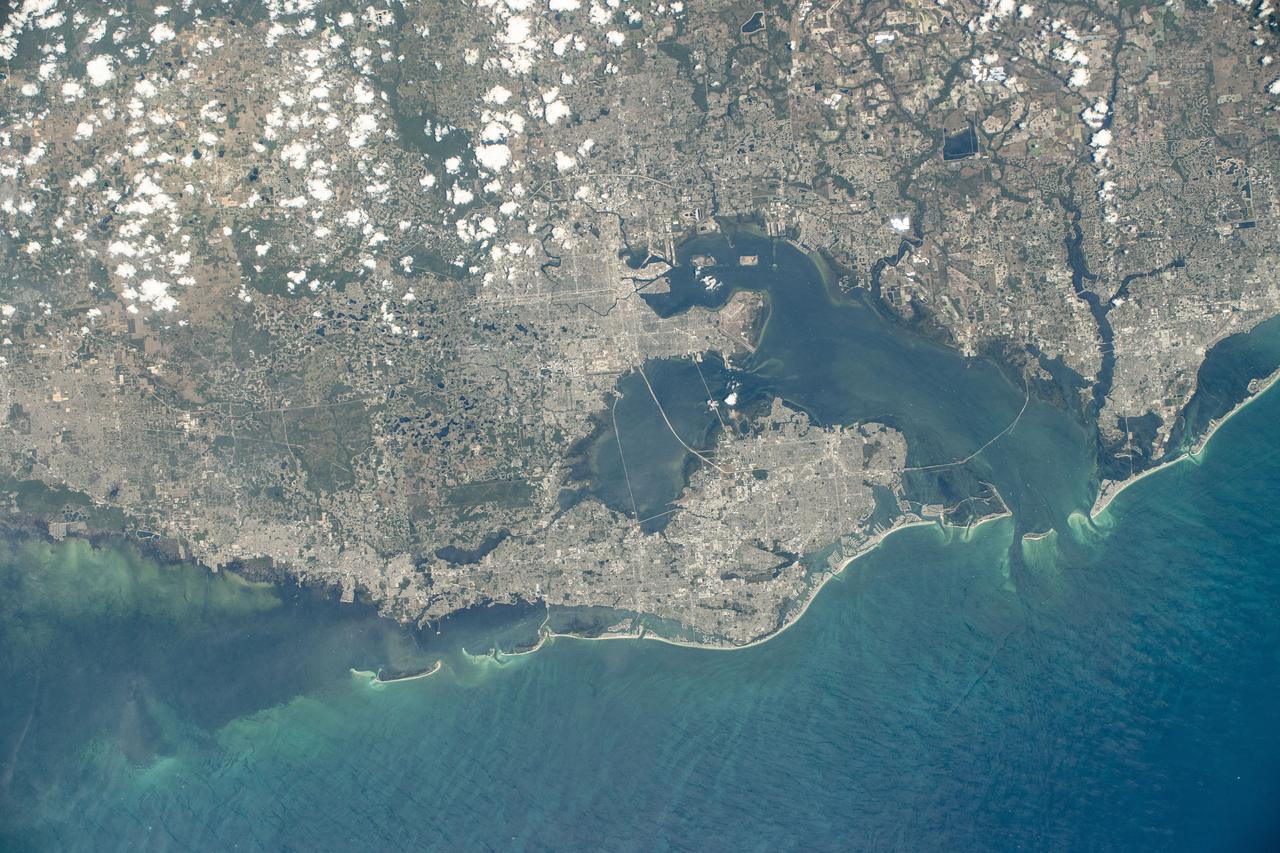
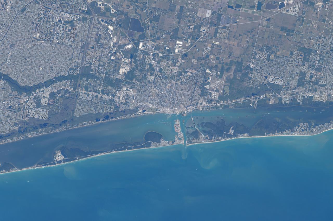
iss071e130741 (May 27, 2024) --- Florida's cities of Tampa, St. Petersburg, Clearwater, and surrounding suburbs on Tampa Bay are pictured from the International Space Station as it orbited 261 miles above the Gulf of Mexico.
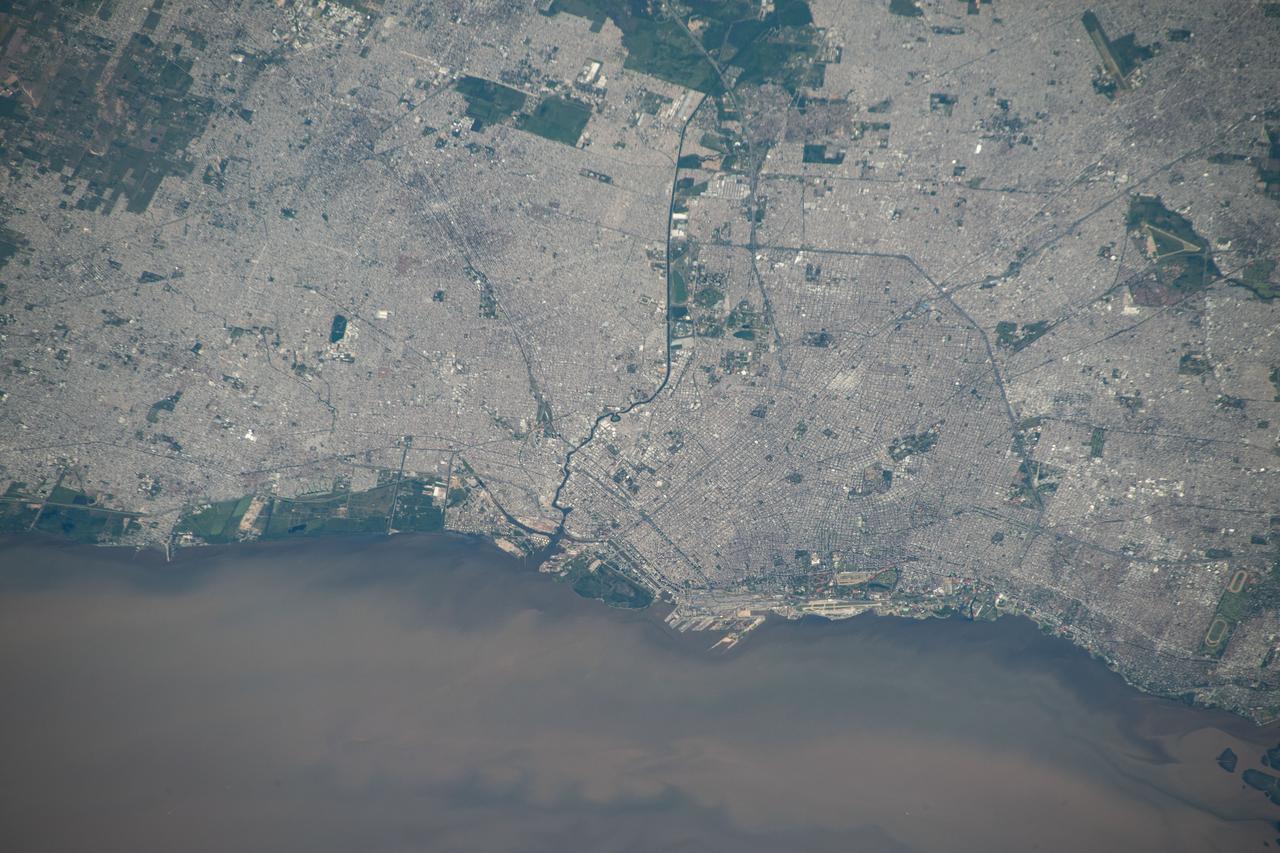
iss070e025974 (Nov. 16, 2023) --- Buenos Aires, Argentina, and its surrounding suburbs on the Rio de la Plata, are pictured from the International Space Station as it orbited 266 miles above the South American nation.
iss071e001300 (April 6, 2024) --- Fort Pierce, Florida, and its surrounding suburbs are pictured from the International Space Station as it orbited 258 miles above The Sunshine State's Atlantic coast.
iss073e0000370 (April 22, 2025) --- Phoenix, Arizona, with a population of over 1.6 million and surrounded by numerous suburbs, is pictured at approximately 4:13 a.m. local time from the International Space Station as it orbited 259 miles above.

iss071e051833 (May 6, 2024) --- Asunción, the capital city of Paraguay on the Paraguay River, and its suburbs across the border from Argentina are pictured from the International Space Station as it orbited 261 miles above South America.
iss071e695407 (Sept. 16, 2024) --- The city lights of Moscow, Russia, dotted by its surrounding suburbs, are pictured from the International Space Station as it orbited 264 miles above just west of the Volga River.
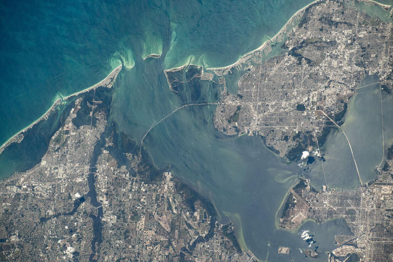
iss071e130773 (May 27, 2024) --- Tampa, Florida, and its surrounding suburbs on Tampa Bay and the Gulf of Mexico are pictured from the International Space Station as it orbited 261 miles above the Sunshine State.

iss069e008226 (May 2, 2023) --- The city lights of St. Louis, Missouri, and its suburbs, fan out west of the Mississippi River in this photograph from the International Space Station as it orbited 262 miles above. The Mississippi separates the Show-Me State from the Prairie State of Illinois.
iss072e399013 (Dec. 19, 2024) --- The city lights of Miami, Florida, the seat of Miami-Dade County with a population of about 456,000 citizens, and its surrounding suburbs are pictured at approximately 4:07 a.m. local time from the International Space Station as it orbited 256 miles above the Atlantic Ocean.

iss067e031423 (April 27, 2022) --- Houston, Texas (home of NASA's Johnson Space Center) and its surrounding suburbs are pictured from the International Space Station as it orbited 261 miles above the Lone Star State. Also prominent in this photograph, are Galveston Bay and Galveston Island on the Gulf of Mexico.
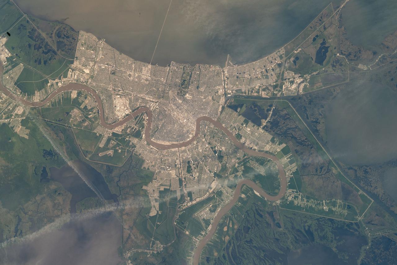
iss067e184608 (April 28, 2022) --- New Orleans, Louisiana, and its surrrounding suburbs, including Gretna, Metarie, and Kenner, are pictured along the Mississsippi River with Lake Ponchartrain at top. The International Space Station was just off the southeast coast of the Pelican State orbiting 264 miles above the Gulf of Mexico at the time of this photograph.
iss064e041140 (March 8, 2021) --- The city lights of Moscow and its suburbs seemingly branch out towards an aurora in this photograph taken from the International Space Station as it orbited 263 miles above the Volga River in Russia. Credit: Roscosmos
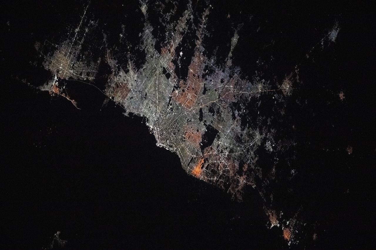
iss073e0176332 (May 20, 2025) --- The Argentinian cities of La Plata (top left) and Buenos Aires and their surrounding suburbs with a combined population of about 13.66 million are pictured at approximately 4:43 a.m. local time from the International Space Station as it orbited 267 miles above.
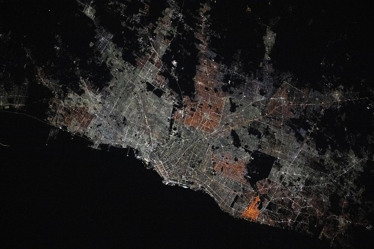
iss073e0176306 (May 20, 2025) --- Buenos Aires, Argentina, the South American nation's largest city with a population of about 3.12 million, surrounded by numerous suburbs on the bank of the Rio de la Plata is pictured at approximately 4:43 a.m. local time from the International Space Station as it orbited 267 miles above.
iss073e0175700 (May 23, 2025) --- The Saudi Arabian cities of Abha (lower left) and Khamis Mushait (center) and their surrounding suburbs with a combined population of about 2.44 million are pictured at approximately 11:32 p.m. local time from the International Space Station as it orbited 259 miles above.
iss073e0429954 (June 21, 2025) --- Colorado's Western Slope region, highlighted by the city of Grand Junction and its surrounding suburbs (at center), is pictured from the International Space Station as it orbited 261 miles above the Centennial State. The municipality's economy is primarily supported by the agribusiness industry, including cattle ranching and fruit cultivation.
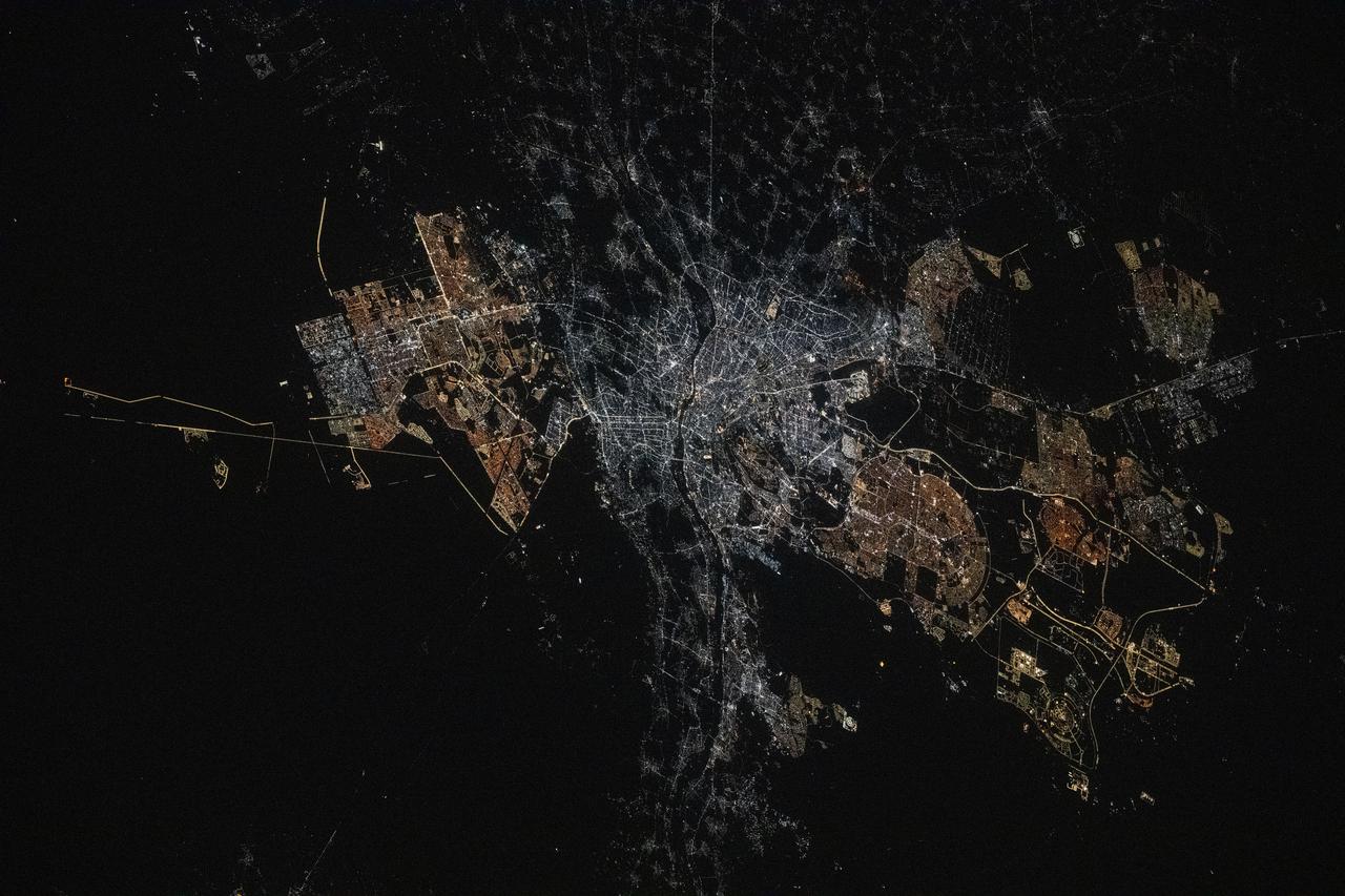
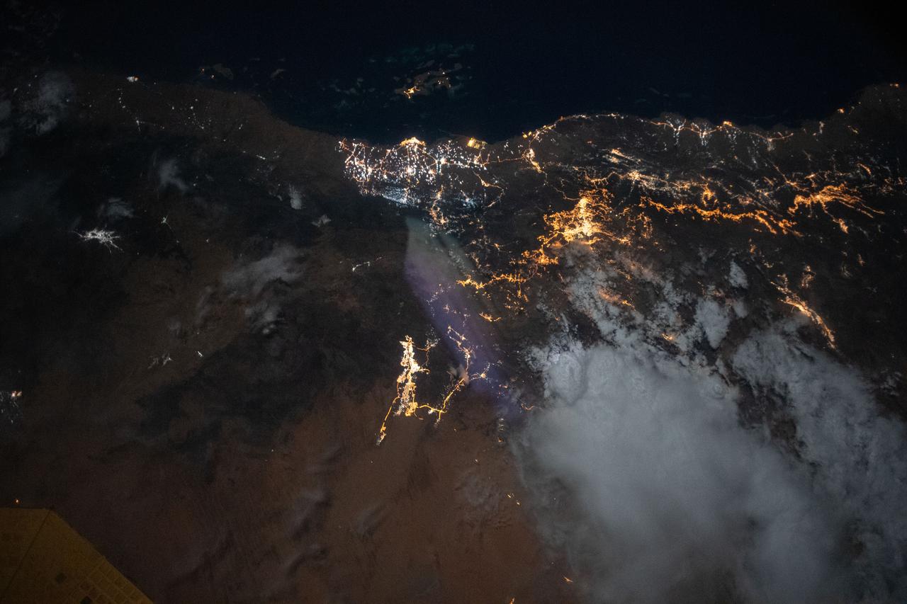
iss073e0134628 (May 22, 2025) --- Cairo, Egypt, the Arab nation's largest city with a population of 10.1 million and located near the Nile Delta, and its surrounding suburbs are pictured at approximately 12:!6 a.m. local time from the International Space Station as it orbited 259 miles above.
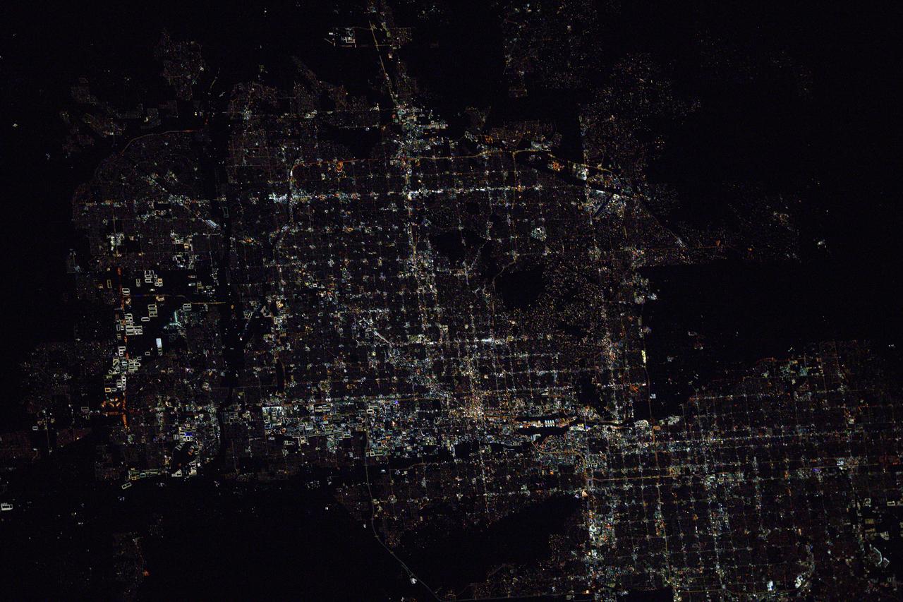
iss073e0075865 (May 16, 2025) --- The metropolitan Phoenix, Arizona, area surrounded by suburbs such as Glendale, Scottsdale, and Tempe, is pictured at approximately 1:55 a.m. local time from the International Space Station as it orbited 260 miles above the Mexican state of Sonora near the U.S. border.
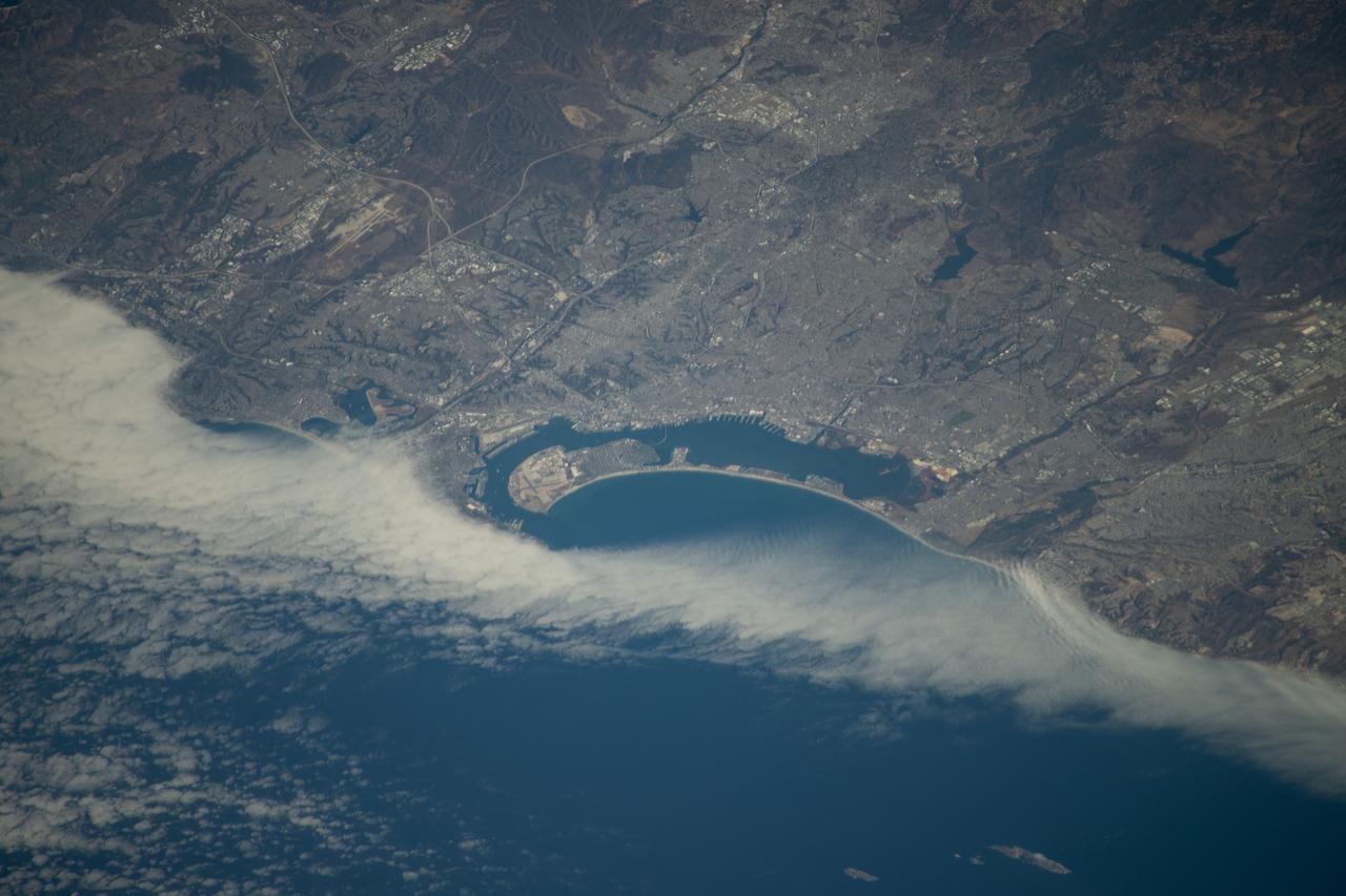
iss072e010297 (Oct. 2, 2024) --- San Diego Bay, surrounded by the city of San Diego, California, and its suburbs near the U.S.-Mexico border, is pictured from the International Space Station as it orbited 257 miles above the Pacific Ocean.
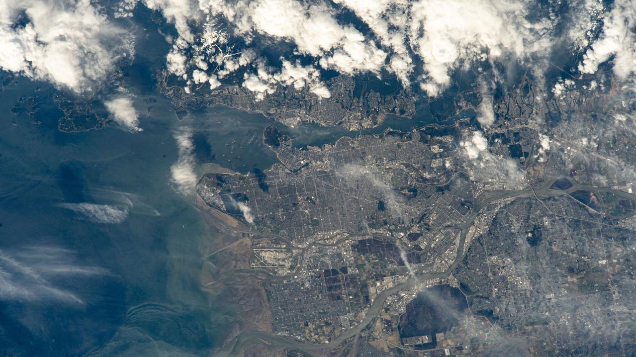
iss071e006133 (April 9, 2024) --- Vancouver, British Columbia, and its surroundng suburbs on the Strait of Georgia are pictured from the International Space Station as it orbited 261 miles above Canada. Toward lower center, is the Fairmont Vancouver Airport on Sea Island.
iss063e006708 (May 5, 2020) --- The city lights of Jazan (top center) and its suburbs on the Persian Gulf coast of Saudi Arabia are easily visible from the International Space Station during an orbital night pass. Just off the coast of Jazan is the Farason Island Marine Sanctuary.
iss072e399194 (Dec. 19, 2024) --- The city lights of Salt Lake City, the capital of Utah, and its surrounding suburbs are pictured at about 5:17 a.m. local time from the International Space Station as it orbited 258 miles above.
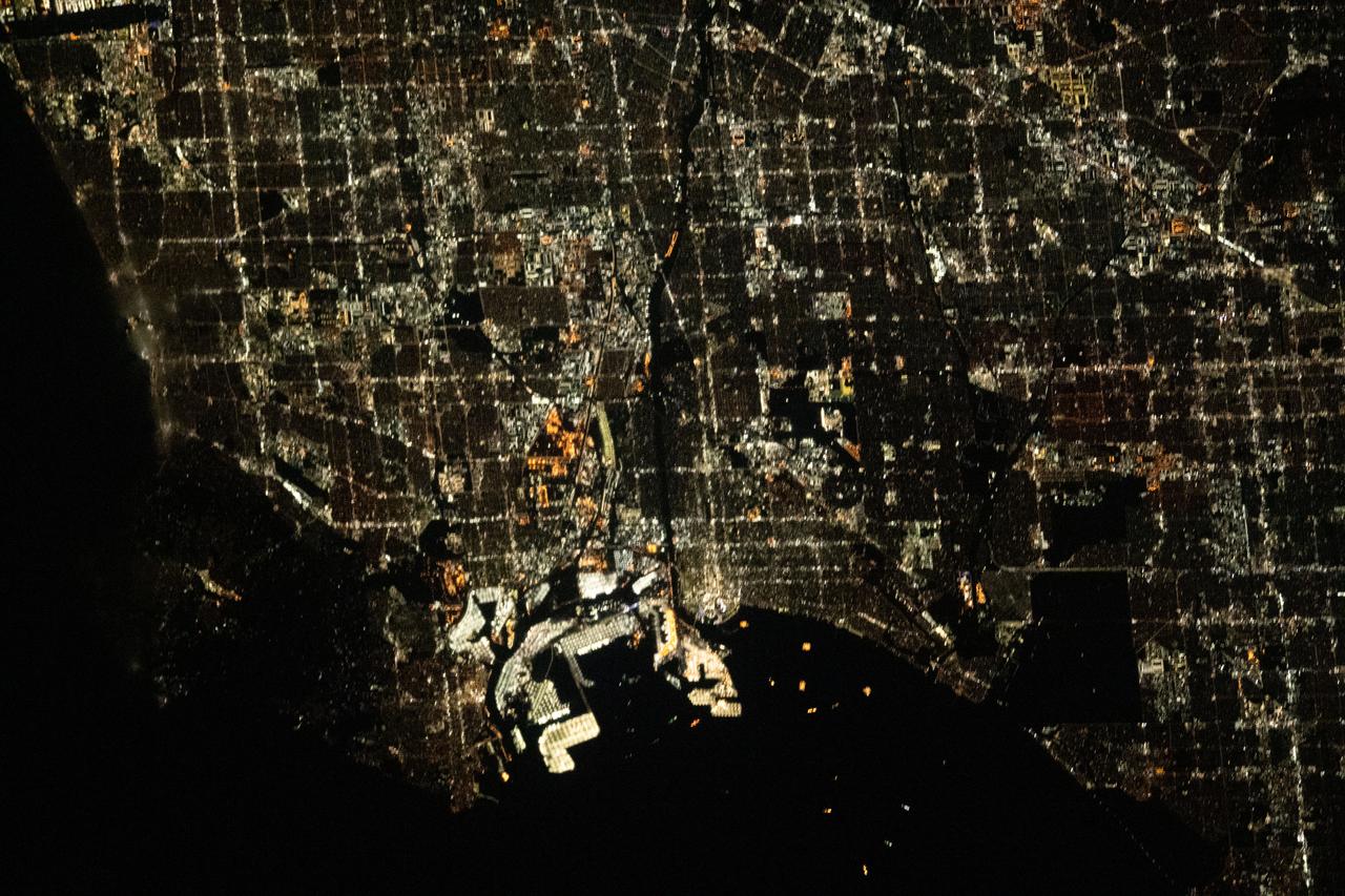
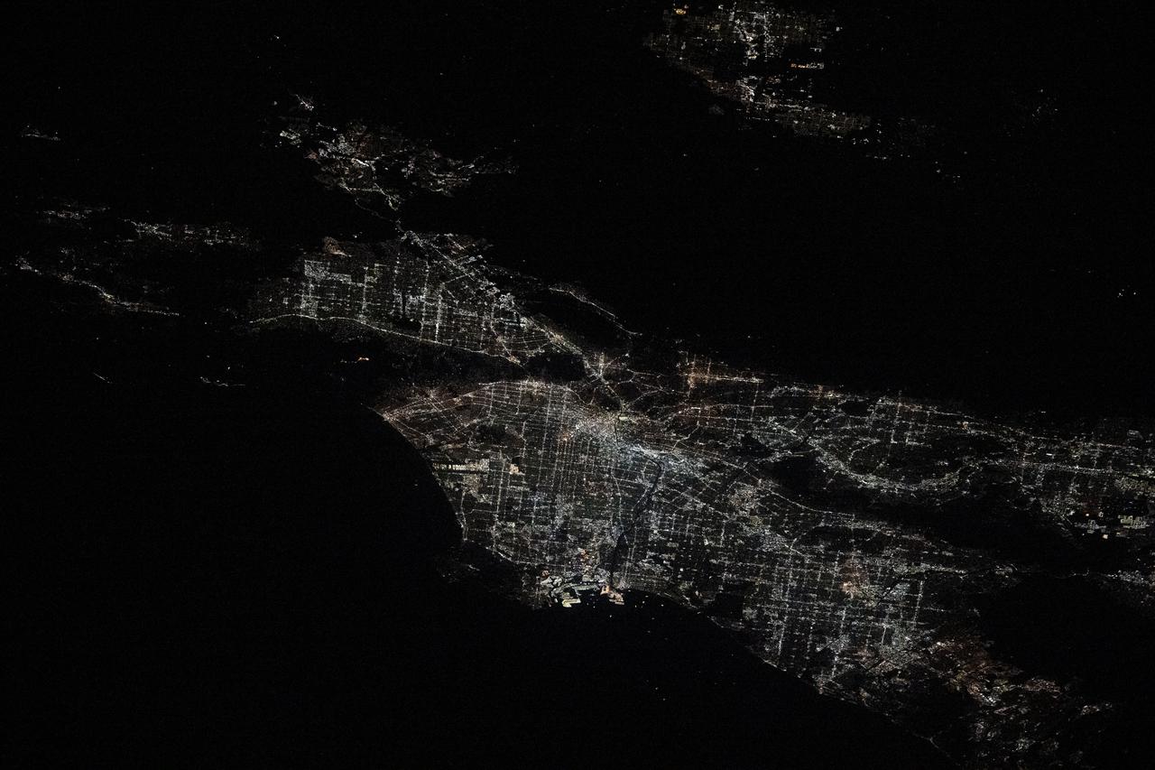
iss069e032998 (July 19, 2023) --- The city lights of Los Angeles, California, and its surrounding suburbs, are pictured from the International Space Station as it orbited 261 miles above. Terminal Island, an artificial island containing the ports of Los Angeles and Long Beach, is featured prominently at the bottom center of this photograph.
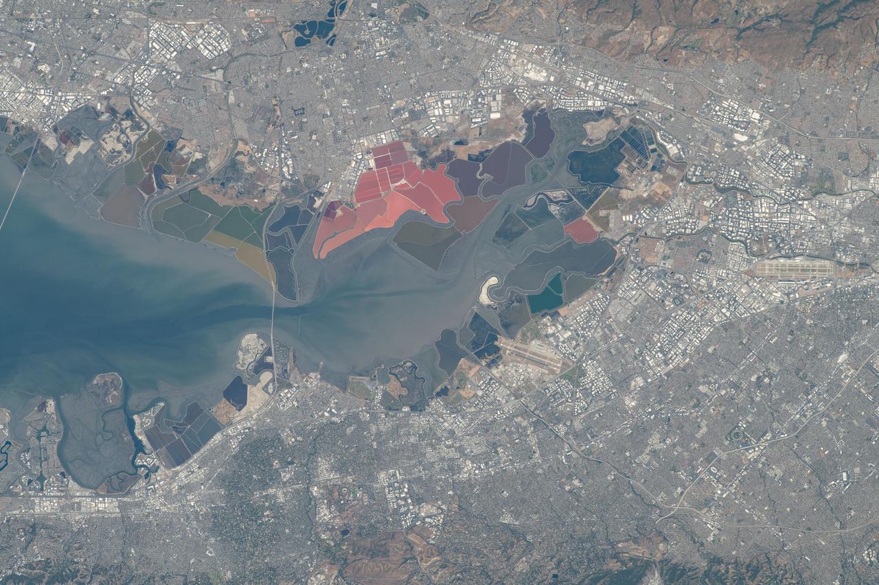
iss069e016644 (May 31, 2023) --- The southern portion of San Francisco Bay in California is surrounded by the Silicon Valley region, famed for its high technology industries, which includes numerous suburbs such as Stanford, Palo Alto, San Jose, and Fremont. The International Space Station was orbiting 258 miles above the Pacific coast at the time of this photograph.
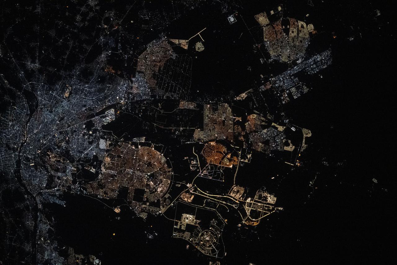
iss073e0343877 (July 15, 2025) --- Egypt's metropolitan area of Cairo, New Cairo City, and Giza, including their surrounding suburbs at the base of the Nile Delta with a population of about 22.6 million, is pictured at approximately 2:21 a.m. local time from the International Space Station as it orbited 259 miles above.

iss073e0222649 (May 26, 2025) --- Jakarta, Indonesia, with a metropolitan population of about 32.6 million including its suburbs, and fishing boats illuminated on the Java Sea are pictured at approximately 11:47 p.m. local time from the International Space Station as it orbited 261 miles above the Indian Ocean.
iss073e0685684 (Aug. 21, 2025) --- Underneath a starry night sky, the city lights of New Delhi, India, and its surrounding suburbs glitter below Earth's atmospheric glow and at the edge of the Himalayas. This photograph was taken at approximately 2:55 a.m. local time as the International Space Station orbited 260 miles above.

ISS007-E-07360 (14 June 2003) --- This regional view of Salt Lake City, Utah taken by an Expedition 7 crewmember onboard the International Space Station (ISS) shows the city and its suburbs nestled between the Wasatch Front and the Great Salt Lake. The core of Interstate Highway 15 runs North-South through the valley, with suburbs arrayed east and west of the highway. An important issue facing Salt Lake City’s growing population is preservation and allocation of water resources. Utah is in its fifth year of drought. One of the most dramatic effects of the drought visible in this picture is the fact that the lake levels are so low that Antelope Island is separated from the mainland by dry lakebed. Expansive productive wetlands occur where freshwater flows from the Wasatch Range and into the lake. The southern end of this network of wetlands can be seen in the image.
SL2-05-393 (22 June 1973) --- The nation's capital lies astride the Potomac River (38.5N, 77.5W) at the head of the Potomac Estuary. Baltimore, MD, also in the scene, is connected to Washington by the Baltimore-Washington Parkway. The suburbs of both cities tend to cluster around the Washington and Baltimore Beltways. Most of the countryside in the eastern two-thirds of this scene is either heavily forested or is in farming, dairy operations or poultry production. Photo credit: NASA
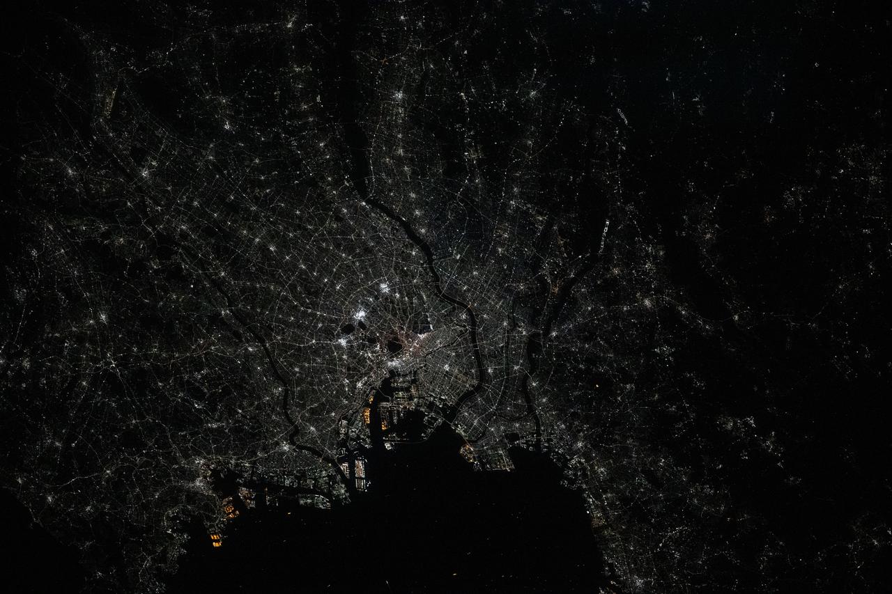
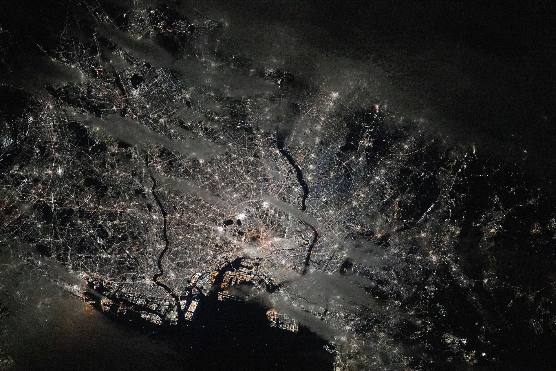
iss073e0548147 (Aug. 26, 2025) --- Tokyo, Japan, and its surrounding suburbs—the world’s most populous metropolitan area with about 39.1 million people—are pictured at approximately 1 a.m. local time from the International Space Station as it orbited 262 miles above. Visible landmarks include Haneda Airport on Tokyo Bay (lower center) and the Imperial Palace (the dark area at center) in the heart of downtown Tokyo. Credit: JAXA (Japan Aerospace Exploration Agency)
iss073e0119293 (May 20, 2025) --- Rio de Janiero, Brazil's capital and second most-populous city, along with its surrounding suburbs, is pictured in between the dark voids representing Nova Iguaçu Volcano (left) and Guanabara Bay (right) at approximately 3:06 a.m. local time from the International Space Station as it orbited 264 miles above the Atlantic Ocean.
iss073e0420568 (Aug. 3, 2025) --- California's San Francisco Bay Area surrounded by the cities of San Francisico, Oakland, and San Jose, and their suburbs, is pictured from the International Space Station as it orbited 260 miles above the Golden State. Visible landmarks include the Golden Gate Bridge and the Don Edwards San Francisco Bay National Wildlife Refuge.
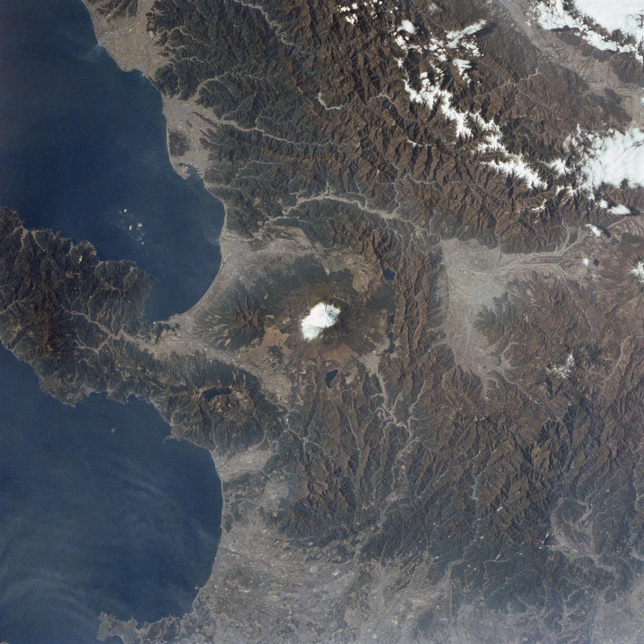
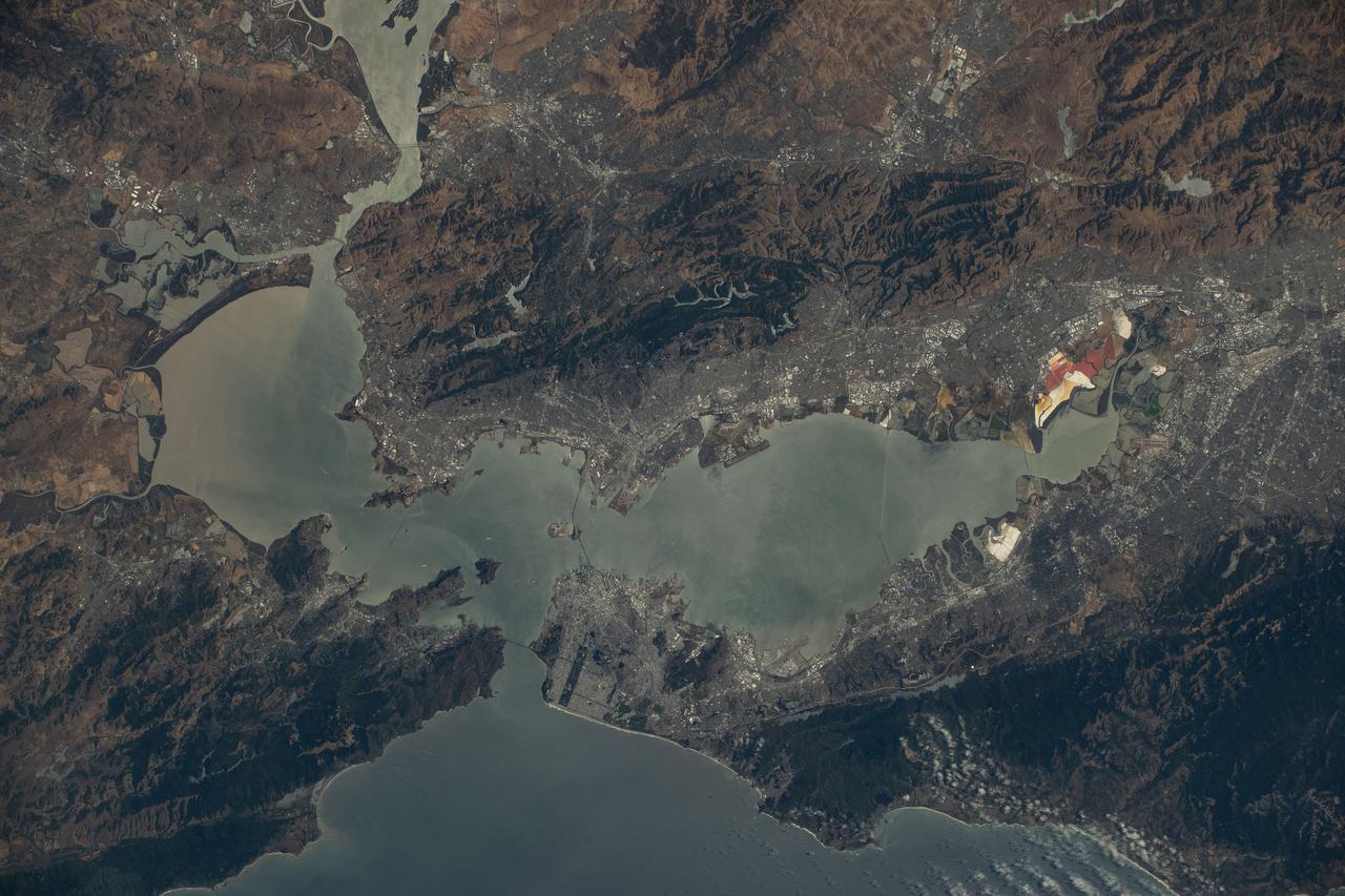
STS002-09-390 (12-14 Nov. 1981) --- Honshu Island, Japan, and its snow-covered Fuji-San or Fuji-Yama volcano are the features of this 70mm frame. The volcano peak is 12,400 feet tall. The western suburbs of Tokyo are at right edge of the photograph. Isu Peninsula is at the bottom, separating the Suruga and Sagami Bay. Other large cities include Yokohama, Kozu, Shizuoka, Namazu and Odawara. Photo credit: NASA

iss070e108427 (March 5, 2024) --- Rio De Janeiro, Brazil (at right), and its suburbs just across the Guanabara Bay are pictured from the International Space Station as it orbited 265 miles above the Atlantic Ocean. Toward the bottom, is the eight-and-a-quarter-mile long President Costa e Silva Bridge linking Rio de Janeiro with the city of Niterói.
iss072e454582 (Jan. 10, 2024) --- City lights illuminate the Los Angeles, California, metropolitan area at approximately 2:30 a.m. local time as the Palisades, Hurst, and Eaton wildfires rage around nearby suburbs including Malibu, San Fernando, and Pasadena. The International Space Station was orbiting 258 miles above the southwestern United States at the time of this photograph. Credit: NASA/Don Pettit
iss073e0120414 (May 19, 2025) --- São Paulo, Brazil, the South American nation's largest city with a population of about 11.9 million, and its surrounding suburbs including Guarulhos, with a population of about 1.29 million, are pictured at approximately 3:54 a.m. local time from the International Space Station as it orbited 265 miles above the Atlantic Ocean.
iss073e0124971 (May 19, 2025) --- The Brazilian coast on the Atlantic Ocean is lit by the nation's two largest cities of Rio de Janiero and São Paulo surrounded by its suburbs and numerous inland towns and villages. The International Space Station was orbiting 263 miles above Brazil at approximately 3:52 a.m. local time when this photograph was taken.
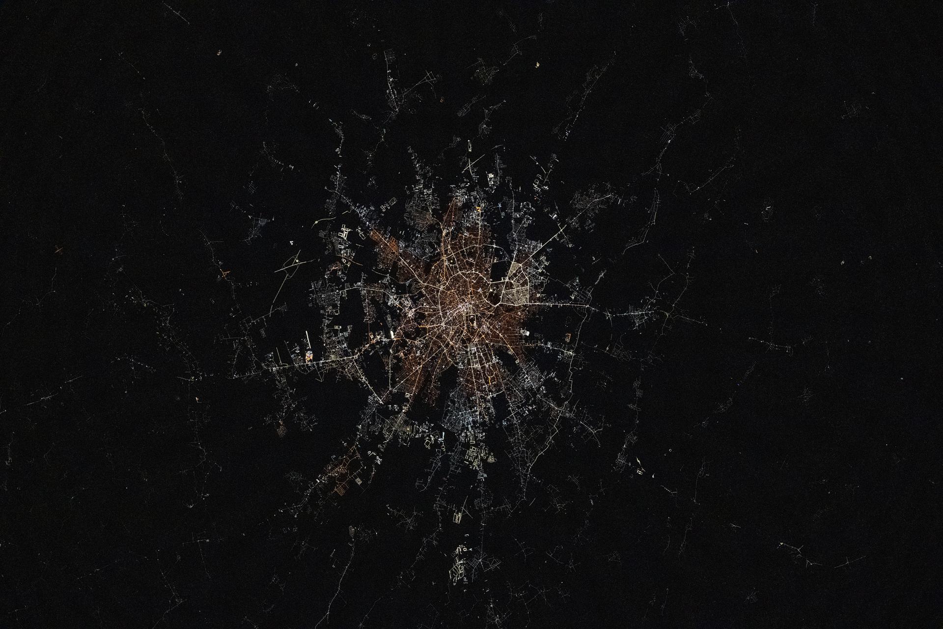
iss073e1047246 (Nov. 2, 2025) --- Bucharest, Romania—the nation's capital with a metropolitan population of about 1.78 million—transitions from older, amber-hued sodium-vapor lights in its city center to modern, white cooler LED lighting in its outskirts and suburbs. This photograph was taken from the International Space Station as it orbited 261 miles above Eastern Europe at approximately 11:15 p.m. local time.

iss073e1047210 (Nov. 2, 2025) --- Thessaloniki, Greece—a 2,300-year-old port city on the Thermaic Gulf with a metropolitan population of about 815,000—is pictured at approximately 11:14 p.m. local time from the International Space Station as it orbited 263 miles above the Greek Peninsula. Its city lights transition from older, amber-hued sodium-vapor lights in its city center to modern, white cooler LED lighting in its outskirts and suburbs.
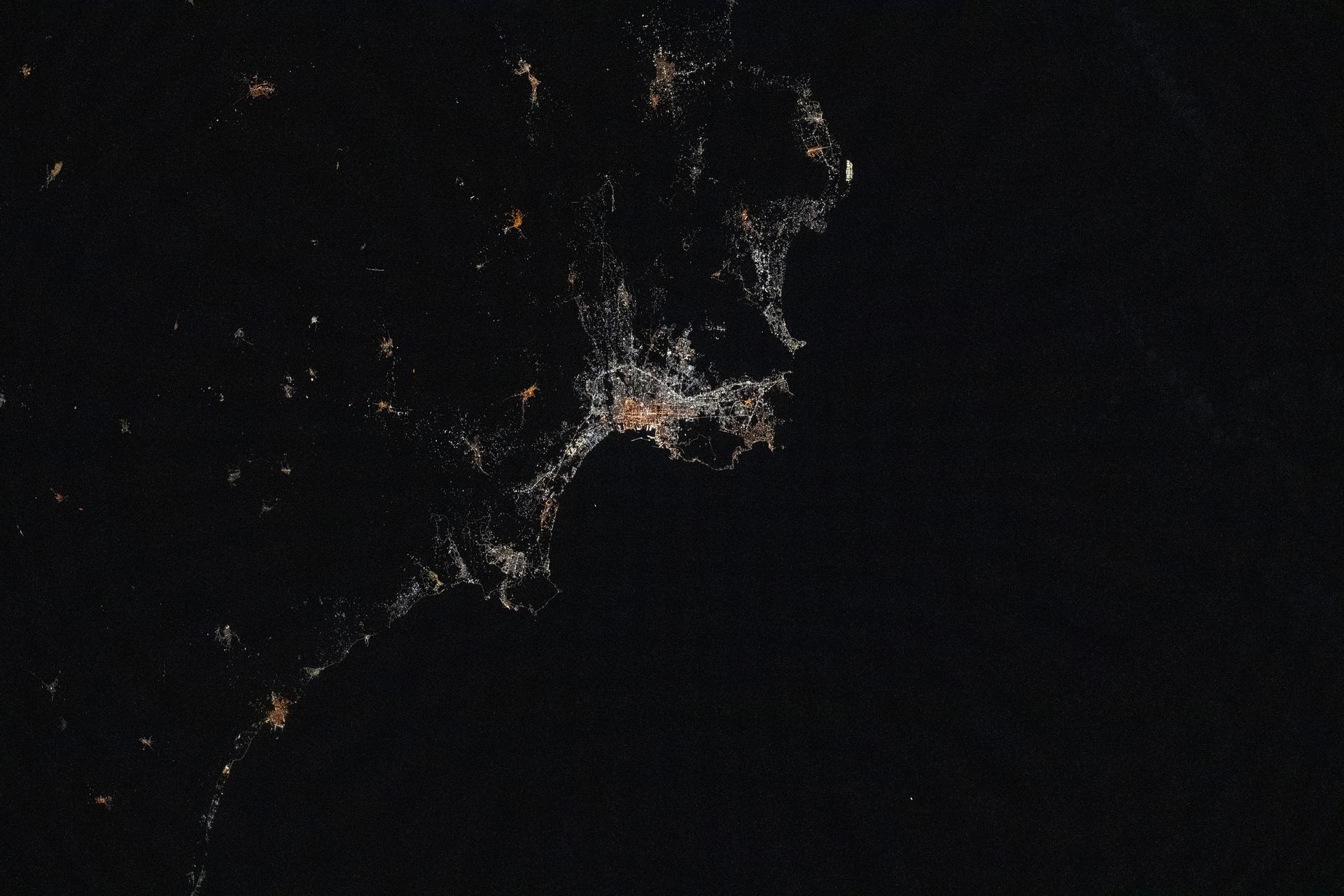
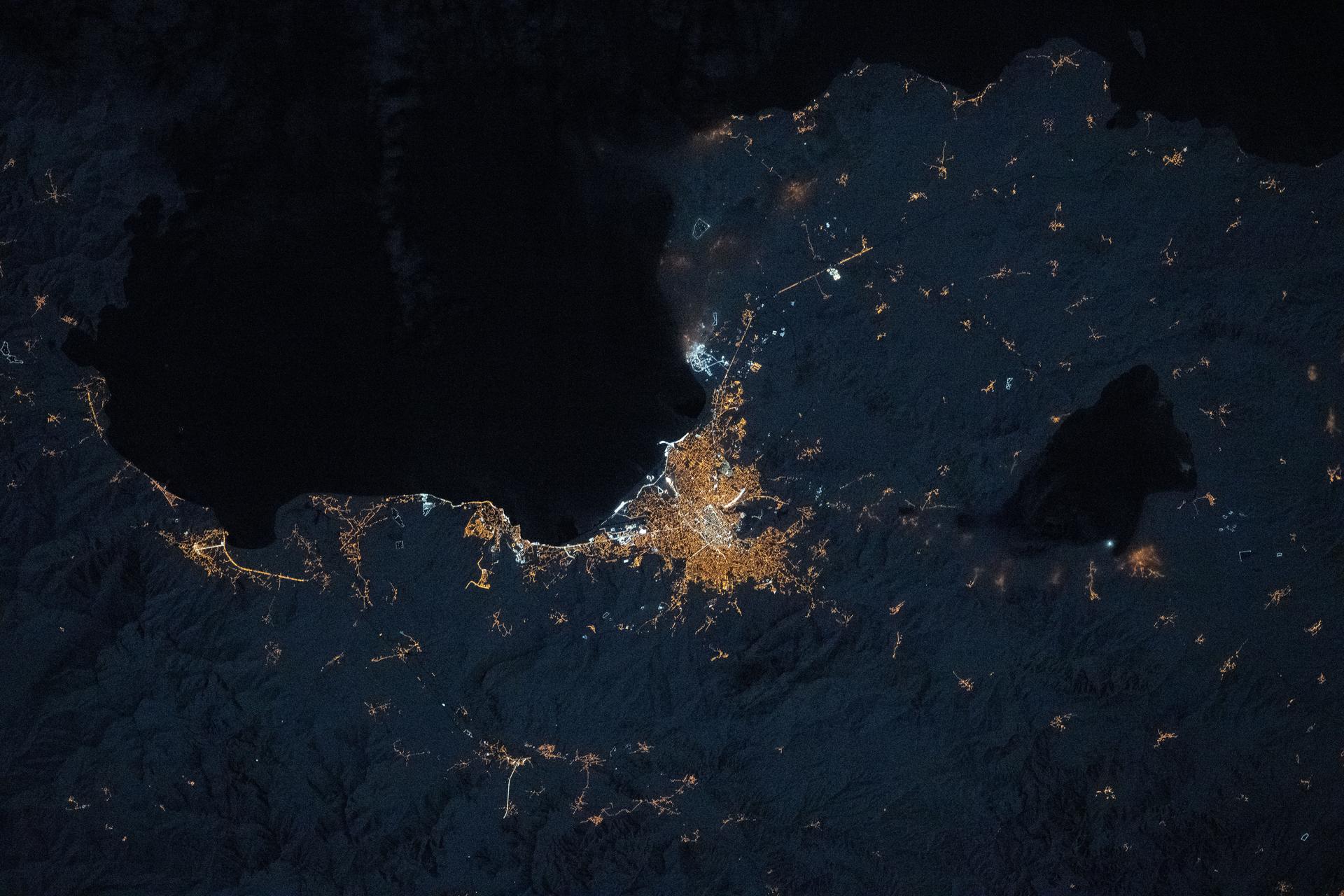
iss073e1047080 (Nov. 2, 2025) --- Palermo, Italy—a 2,700-year-old city on the Sicilian coast of the Tyrrhenian Sea—is pictured at approximately 10:12 p.m. local time from the International Space Station as it orbited 260 miles above the Mediterranean Sea. The city’s lights reveal a transition from older, amber-hued sodium-vapor lamps in the historic center to cooler, white LED lighting in the surrounding suburbs.
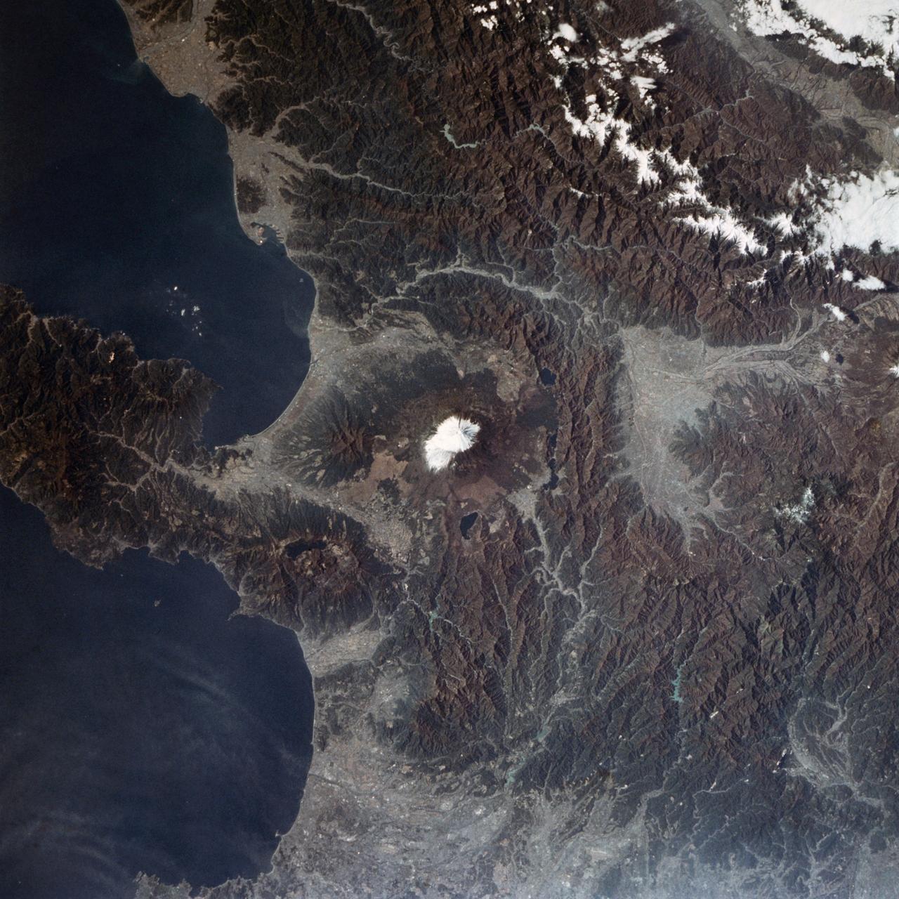
STS002-09-391A (12-14 Nov. 1981) --- Honshu Island, Japan, and its snow-covered Fuji-San or Fuji-Yama volcano are the features of this 70mm frame. The volcano peak is 12,400 feet tall. The western suburbs of Tokyo are at right edge of the photograph. Isu Peninsula is at the bottom, separating the Suruga and Sagami Bays. Other large cities include Yokohama, Kozu, Shizuoka, Namazu and Odawara. Photo credit: NASA
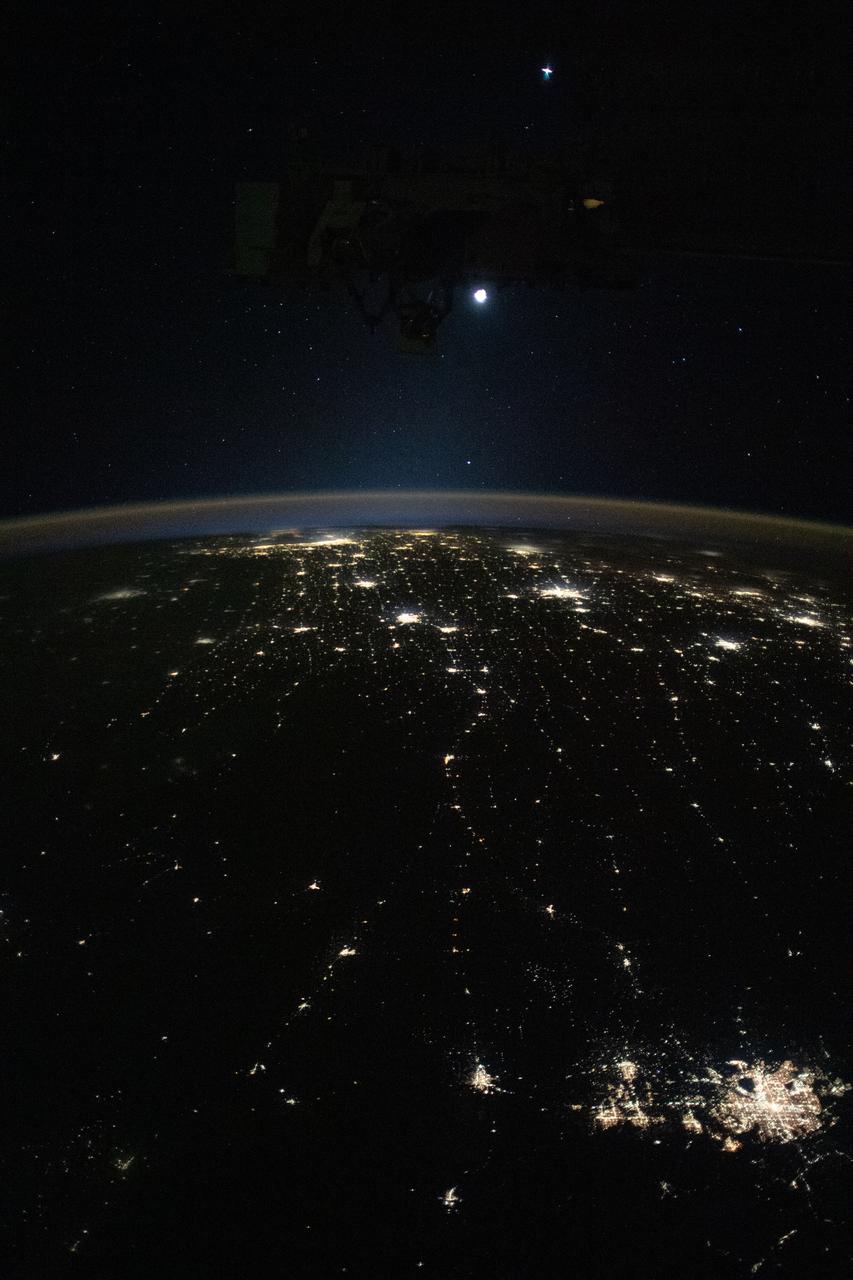
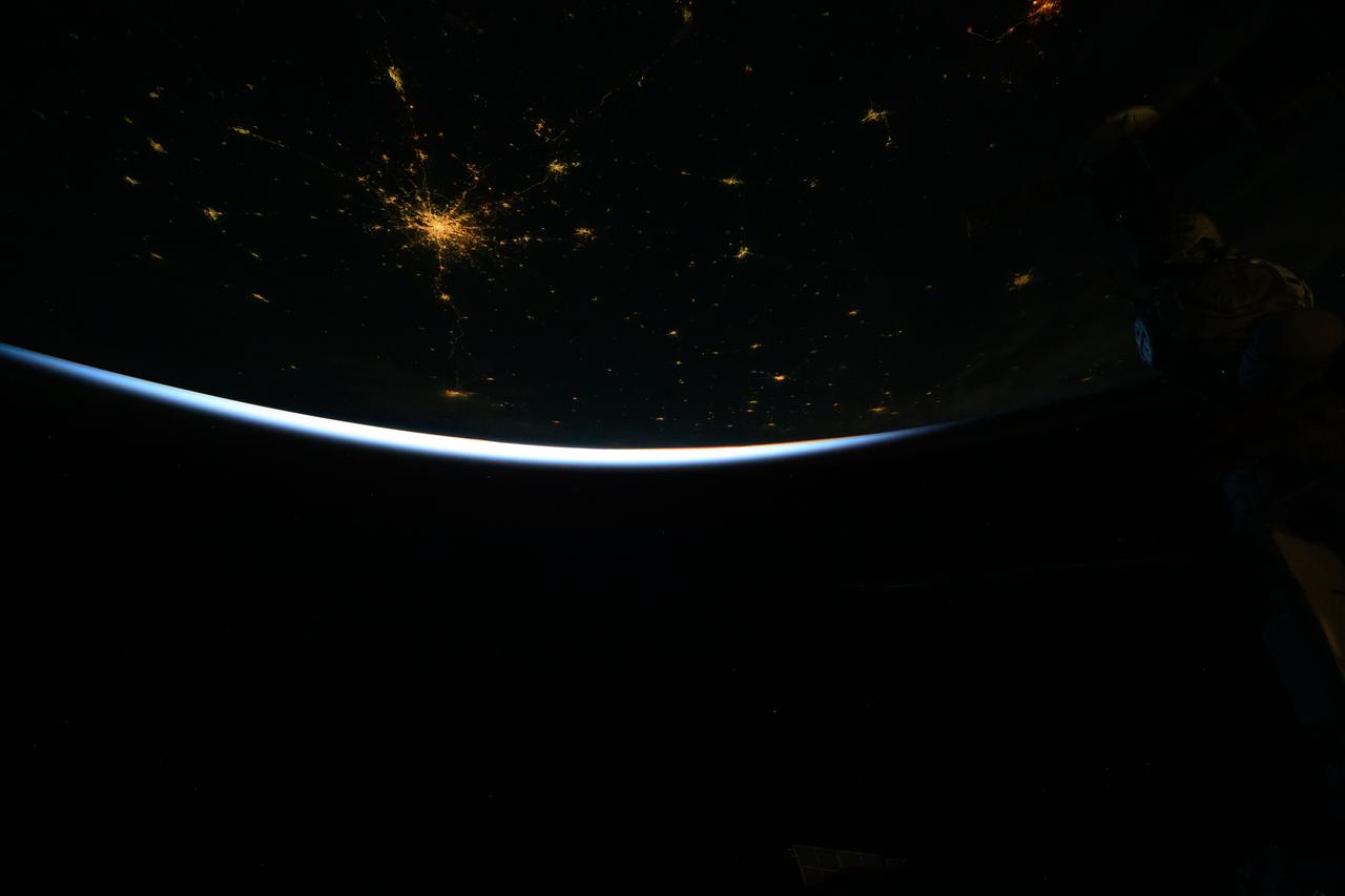
iss070e022666 (Nov. 10, 2023) --- Earth's airglow outlines the planet's horizon with the Moon above in this photograph from the International Space Station as it orbited 260 miles above the midwestern United States. At lower right, the city lights of Denver. Colorado, and its suburbs shine, including the city lights all the way to Chicago, Illinois (at top), and surrounding metropolitan areas.
iss073e0312086 (May 22, 2025) --- At top left, the city lights of Benghazi, Libya, arc downward toward the glow of civilization on Egypt's Nile Delta outlining Africa's Mediterranean Sea coast. Israel's metropolitan lights then round north and east into Istanbul, Turkey (far right), and Athens, Greece, and their surrounding suburbs in southern Europe. Resting in the center of the Mediterranean's darkness is the Greek island of Crete.
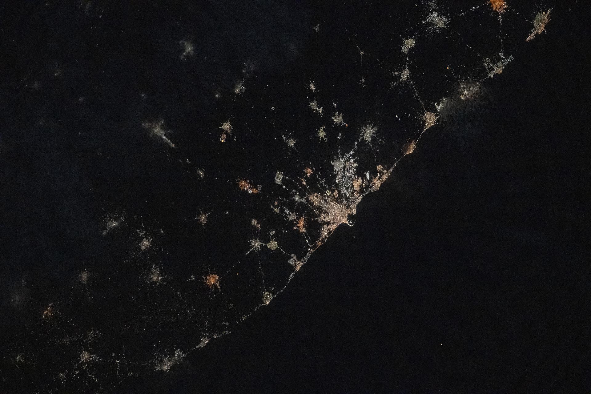
iss073e0686732 (Aug. 30, 2025) --- The atmospheric glow blankets southern Europe and the northwestern Mediterranean coast, outlined by city lights. At left, the Po Valley urban corridor in Italy shines with the metropolitan areas of Milan and Turin and their surrounding suburbs. This photograph was taken at approximately 1:39 a.m. local time from the International Space Station as it orbited 261 miles above Earth.
iss073e0918643 (Oct. 18, 2025) --- Tokyo, Japan, and its surrounding suburbs along Tokyo Bay light up the night, with stops along major rail lines glittering like pearls. The Greater Tokyo Area—the world’s most populated urban center with over 39 million people—is pictured at approximately 4 a.m. local time from the International Space Station as it orbited 262 miles above the island nation.
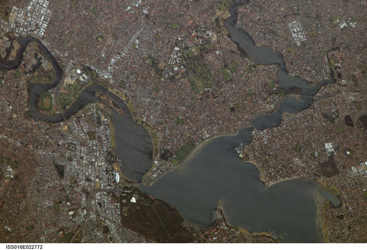
ISS016-E-022772 (11 Jan. 2008) --- Perth, Australia is featured in this image photographed by an Expedition 16 crewmember on the International Space Station (ISS). Perth is the capital of the state of Western Australia, and the largest city of the southwestern continent of Australia with an estimated population of over 1.5 million (December 2006). The downtown area of Perth and the surrounding suburbs are located on flood plain deposits of the Swan and Canning Rivers that flow through the center of the metropolitan area. Perth enjoys a Mediterranean climate, where the summers are hot and dry and winters are cool and moist. Wildfires can develop during the summer months; several large fires threatened the eastern portion of the metropolitan area in 2005. This view captures variations in urban land cover in the visible wavelengths to which the human eye is sensitive (visible red, green, and blue). The downtown center of Perth at left is characterized by large buildings (such as skyscrapers) with white reflective rooftops. Suburbs to the south (across the Swan River) are characterized by higher density of small buildings with predominantly reddish-purple roofs. Several areas of green vegetation are visible in the image. Parks and golf courses comprised mainly of grass present an even green coloration, while the dense tree canopy of Kings Park appears dark green. Variations in the coloration of the Swan and Canning Rivers is due to sunglint, or light reflected off the water surface back to the observer (in this case, a crewmember onboard the ISS).
STS084-727-053 (15-24 May 1997) --- This view of Lima, Peru is among a very few photographed by astronauts who have orbited Earth since the early 1960's. Francisco Pizarro founded the city of Lima in 1535. Lima is located 13 kilometers (8 miles) inland from the Peruvian coast and is surrounded by coastal desert and the Andes mountains. Suburbs of Lima extend in all directions except to the east, where the Andes prohibits growth. The three rivers, Chillion to the northeast of Lima, the Rimac which runs through the northern part of the city, and the Mala to the southeast, all drain the central Andes. The island off the coast is San Lorenzo.
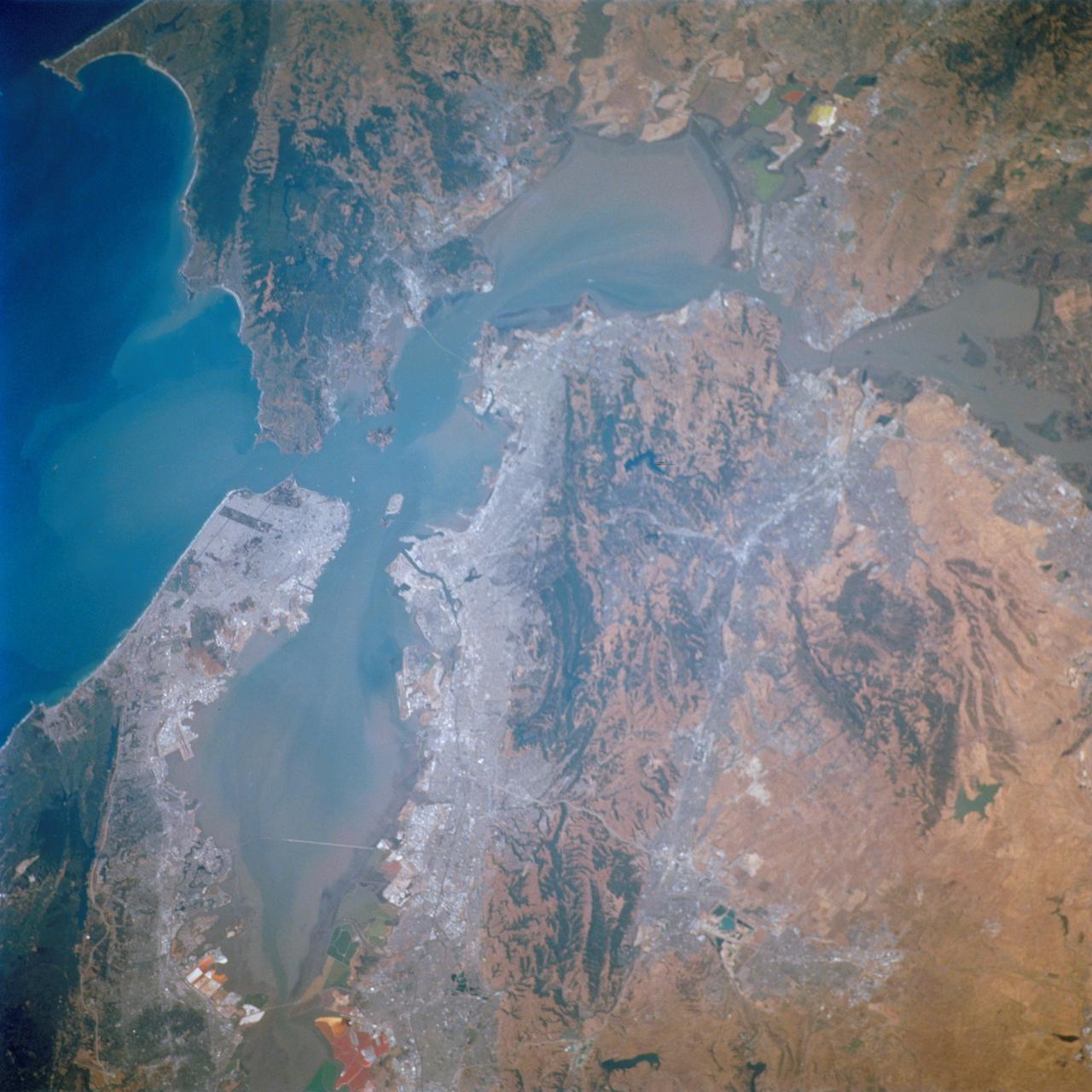
STS111-712-028 (5-19 June 2002) --- This photo featuring the San Francisco Bay area in California was photographed by one of the STS-111 crewmembers aboard the Space Shuttle Endeavour. The gray urban footprint of San Francisco, Oakland, San Jose, and the surrounding suburbs contrasts strongly with the brown and green vegetation in the hillsides. At the top and bottom of the picture the green, red and yellow pools are impoundments and salt evaporation ponds. The Gateway to Astronaut Photography of Earth (link to http://eol.jsc.nasa.gov/sseop/) provides searchable access to other photographs of Earth taken by astronauts.
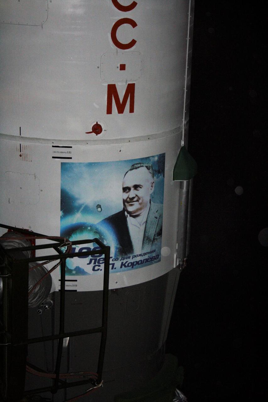
JSC2007-E-03079 (16 Jan. 2007) --- Roll-out of the Progress 24 vehicle occurred on schedule at 7:00 a.m., Jan. 16, 2007 (local time) at the Baikonur Cosmodrome, Kazakhstan. Progress 24 bears on the side of the Soyuz launch vehicle the name of Sergei Korolev, the "Great Designer" of Soviet spacecraft, whose 100th birthday was celebrated on Jan. 12. A portrait of him is painted on the external payload fairing. Korolev, named in his memory, is now the suburb of Moscow where the Russian Mission Control Center resides. After it reaches orbit, a series of pre-programmed engine firings will lead to the automated docking of Progress 24 to the now-vacant Pirs Docking Compartment at 9:00 p.m. CST on Jan. 19. (6:00 a.m. on Jan. 20, Moscow time). Photo Credit: NASA
La Paz, Bolivia is the highest capital in the world, located on the Andes' Altiplano plateau at more than 3500 meters above sea level. It is situated in a bowl-like depression, surrounded by high mountains. La Paz was founded in 1548 by Spanish conquistadors at the site of the Inca settlement of Laja. Like many South American cities, La Paz and its suburbs have seen remarkable growth in the last 30 years. From 1986 to 2017 the population grew from about 400,000 to over 2.3 million. The ASTER image was acquired July 11, 2017. The images cover an area of 27 by 33 kilometers, and are located at 16.5 degrees south, 68.1 degrees west. https://photojournal.jpl.nasa.gov/catalog/PIA21220
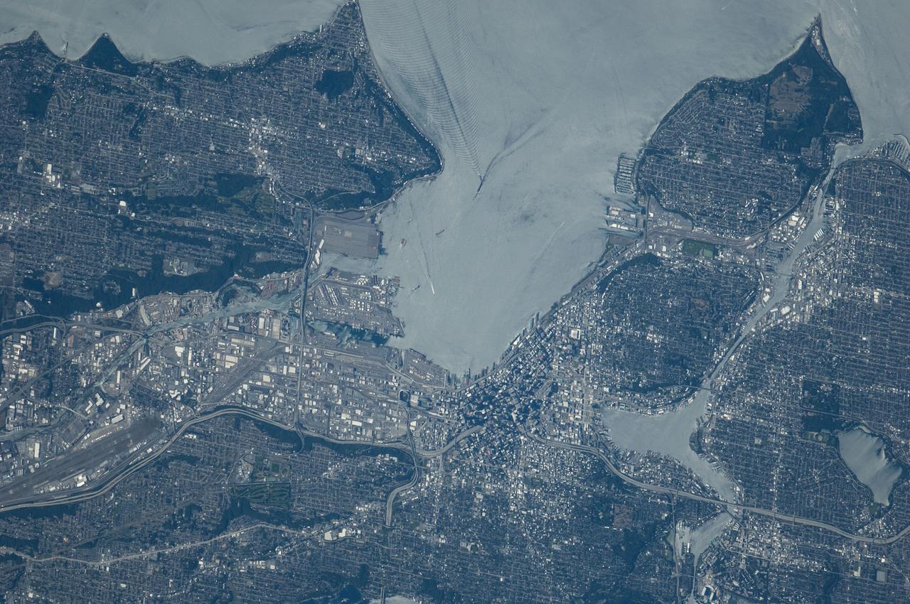
ISS040-E-124198 (6 Sept. 2014) --- Puget Sound is partly reflecting the sun in this detailed image taken by an Expedition 40 crew member on the International Space Station. Patterns of boat wakes are prominent in the sun’s partial reflection zone. The difference between the boat wakes in this view relates to the speed of the boat and the particular patterns (of several) that happen to be captured in the specific light reflection angles at the time the image was taken. The land areas show parts of Seattle. The darkest areas with rectangular grids are suburbs richly covered with trees. The broadly gray zones of the central city (bottom center) are brighter where structures are lower, as in the harbor zone (Harbor Island), and darker where the shadows of high-rise buildings downtown cast black shadows. Interstate Highway 5 bisects downtown.
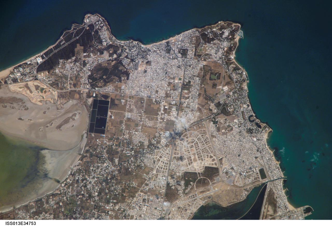
ISS013-E-34753 (8 June 2006) --- Carthage, Tunisia is featured in this image photographed by an Expedition 13 crewmember on the International Space Station. The favorable location of the ancient city of Carthage is clear in this image. Embayments along the coastline provided ready access to the Gulf of Tunis/Mediterranean Sea to the east and southeast. Docks along the coastline (lower right) support the shipping industry. Modern Carthage is a wealthy suburb of the Tunis metropolitan area (the center of which is located to the southwest of the image), as evidenced by dense concentrations of white building rooftops in residential subdivisions to the north and south of the ancient city location. Large tracts of new developments appear to be in progress along the curving, light colored roadways to the southwest of the historical city (lower center). The green shallow waters of an evaporating saline lake are visible at image left ? several such lakes are present in Tunisia and are centers for bird watching-related tourism.
ISS004-E-10288 (21 April 2002) --- This view featuring the San Francisco Bay Area was photographed by an Expedition 4 crewmember onboard the International Space Station (ISS). The gray urban footprint of San Francisco, Oakland, San Jose, and their surrounding suburbs contrasts strongly with the green hillsides. Of particular note are the Pacific Ocean water patterns that are highlighted in the sun glint. Sets of internal waves traveling east impinge on the coastline south of San Francisco. At the same time, fresher bay water flows out from the bay beneath the Golden Gate Bridge, creating a large plume traveling westward. Tidal current channels suggest the tidal flow deep in the bay. Because the ISS orbits are not synchronous with the sun, station crewmembers view Earth with variable solar illumination angles. This allows them to document phenomena such as the sun reflecting differentially off surface waters in a way that outlines complicated water structures.
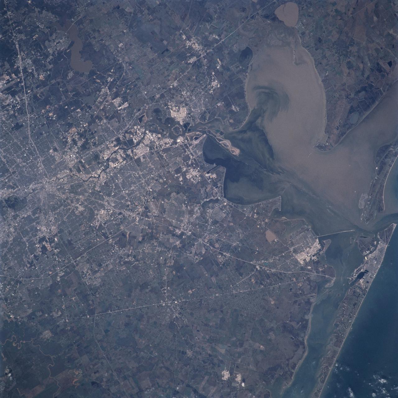
STS098-819-038 (17 February 2001) --- Much of Metropolitan Houston appears in this nearly vertical image photographed with a handheld 70mm camera onboard the Earth-orbiting Space Shuttle Atlantis. Interstate 45 and Highways 146 and 6 can be traced from lower right in Galveston County as they head into different directions toward a wide range of points in the city and its suburbs. NASA's Johnson Space Center can be easily pin-pointed just above the center point in the frame. Other points of interest in the area can be located by tracking over the various U.S., state and interstate highways---10, 51, 610 loop, Beltway 8 and others. Downtown Houston is at left center, but the so-called Uptown area is just out of frame at left. Galveston Bay takes up most of the upper right quadrant. Lake Houston is at upper left. A small piece of the Gulf of Mexico is in lower right.

The National Aeronautics and Space Administration (NASA) Lewis Research Center tested 16 commercially-manufactured electric vehicles, including this Metro, during the mid-1970s. Lewis and the Energy Research and Development Administration (ERDA) engaged in several energy-related programs in the mid-1970s, including the Electric Vehicle Project. NASA and ERDA undertook the program in 1976 to determine the state of the current electric vehicle technology. As part of the project, Lewis and ERDA tested every commercially available electric car model. Electric Vehicle Associates, located in a Cleveland suburb, modified a Renault 12 vehicle to create this Metro. Its 1040-pound golfcart-type battery provided approximately 106 minutes of operation. The tests analyzed the vehicle’s range, acceleration, coast-down, braking, and energy consumption. Some of the vehicles had analog data recording systems to measure the battery during operation and sensors to determine speed and distance. The researchers found the performance of the different vehicles varied significantly. In general, the range, acceleration, and speed were lower than that found on conventional vehicles. They also found that traditional gasoline-powered vehicles were as efficient as the electric vehicles. The researchers concluded, however, that advances in battery technology and electric drive systems would significantly improve efficiency and performance.
SL3-84-202 (July-September 1973) --- A vertical view of the Montevideo, Uruguay area of South America is seen in this Skylab 3 Earth Resources Experiments Package S190-B (five-inch Earth terrain camera) photograph taken from the Skylab space station in Earth orbit. The large body of water is Rio de la Plata which flows into the South Atlantic Ocean at the bottom of the picture. The red plum in the Rio de la Plata is probably sediment moving seaward. The Santa Lucia River enters the Rio de la Plata west of Montevideo and is the major drainage for the region. Note the small Isla del Tigre at the mouth of the Santa Lucia. The white beach and sand dune areas are plainly visible along the coast. A major airport can be seen immediately east of downtown Montevideo. Major thoroughfares and residential areas, such as the bright one in the suburbs, are clearly visible, also. Farm tracts in green and grey rectangular patterns indicate agricultural regions. Photo credit: NASA
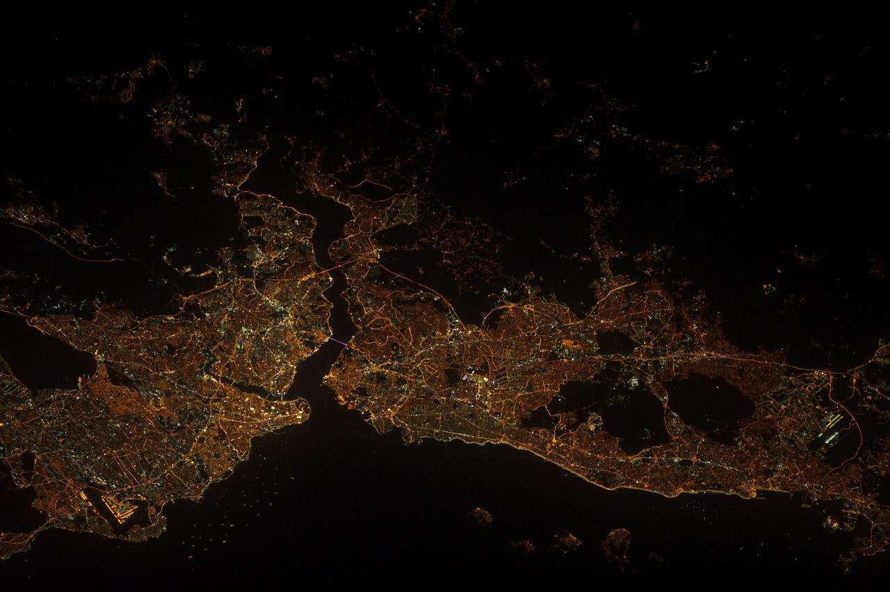
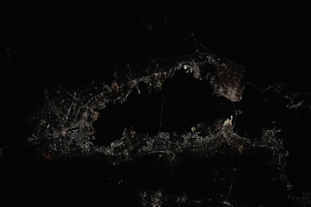
ISS032-E-017547 (9 Aug. 2012) --- A nighttime view of Istanbul, Turkey is featured in this image photographed by an Expedition 32 crew member on the International Space Station. Most of Istanbul?s Asian suburbs (right) appear in this night view from the space station, but only about half the area of the city on the European side (left) can be seen. The margins of the metropolitan area are clearly visible at night, more so than in daylight images. The Bosporus strait (also spelled Bosphorus) (center left) famously separates the two halves of the city, and links the small Sea of Marmara (and the Mediterranean Sea to its south) to the Black Sea (indistinguishable in this night view, top right). The strait is 31 kilometers long, most of which is visible in this view. The Bosporus is a very busy waterway, with larger ships passing to and from the Black Sea competing with numerous ferries that cross between the two halves of the city. Apart from the dark Sea of Marmara (lower margin of the image), the other large dark areas are all wooded hills which provide open spaces for the densely populated city of Istanbul ? one of the largest in Europe with 13.5 million inhabitants. The old city occupies the prominent point at the entrance to the strait. Major traffic arteries are the brighter lines crossing the metropolitan area, and also mark all the shorelines. The First Bosporus Bridge and Second Bridge (also known as the Fatih Sultan Mehmet Bridge) can be seen spanning the strait. The brilliant lights of both international airports serving the region also stand out at lower left and lower right.
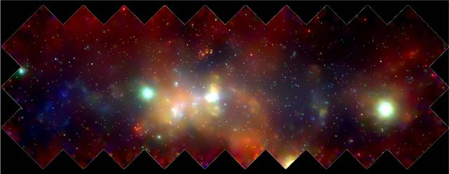
The Chandra X-Ray Observatory (CXO) has made a sturning, high-energy panorama of the central regions of our Milky Way galaxy. The findings are an important step toward understanding the most active area of the Milky Way as well as other galaxies throughout the universe. This 400 by 900-light-year mosaic of several CXO images reveals hundreds of white dwarf stars, neutron stars, and black holes bathed in an incandescent fog of miltimillion-degree gas. The diffuse x-ray emission seems to be related to the turmoil and density of matter in the inner Milky Way. Stars are forming there at a much more rapid rate than in the galactic "suburbs." Many of the most massive stars in the galaxy are located in the galactic center and are furiously boiling off their outer layers in searing stellar winds. Supernova explosions are far more common in the region and send shock waves booming through the inner galaxy. The super massive black hole at the center of the galaxy is located inside the bright white patch in the center of the image. The colors indicate x-ray energy bands-red (low), green (medial), and blue (high). A supernova occurs when a massive star has used up its nuclear fuel and the pressure drops in the central core of the star. The matter in the core is crushed by gravity to higher and higher densities, and temperatures reach billions of degrees. Under these extreme conditions, nuclear reactions occur violently and catastrophically reversing the collapse. A thermonuclear shock wave races through the now expanding stellar debris, fusing lighter elements into heavier ones and producing a brilliant visual outburst. (Photo credit: NASA/UMass/D. Wang et al)

“The day after the Columbia tragedy I knew exactly what I wanted to do with my life. I go to my physics class and tell a friend, ‘I want to go work for NASA.’ My physics teacher walks by and overhears the conversation. She starts the class and says ‘I want to go around the classroom and hear about what everybody wants to do with their life.’ She gets to me. I was super excited. ‘I’m going to work for NASA, I’m going to be an engineer, I’m going to make sure everybody flies safe.’ And she bursts out laughing. And everyone else starts laughing. I’m like, ‘what is the joke?’ And she says to me, ‘If you ever get the opportunity to work for NASA, you make sure you come take me out to lunch.’ And that ended up being the joke of the day at my entire high school. “I think we have a very long way to go. I think that there are not enough educational resources. There are not enough pipeline opportunities. I come from a single-parent family. We weren’t rich. We lived in a New Jersey suburb in a very small town where the idea of a girl going to NASA — it just seemed impossible. I think that we have long way to go to reach out to some of those smaller, under-serving communities where individuals may not have the resources. Where teachers can’t even motivate kids to do something big because they don’t even believe it themselves. I do believe there are strides happening — but I don’t think we’re there yet.” — Brittani Sims, Flight Systems Engineer, Kennedy Space Center Interviewer: NASA / Thalia Patrinos
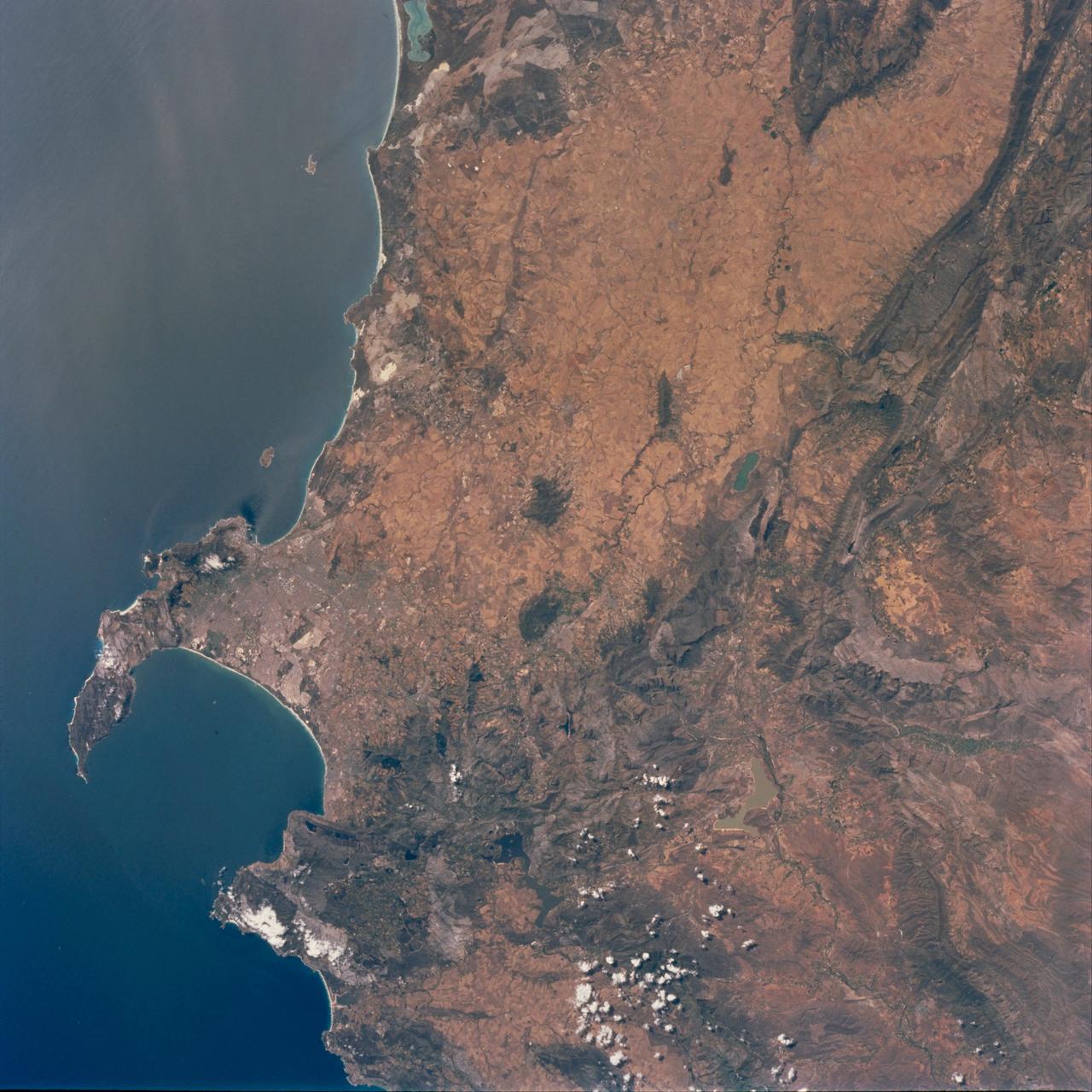
STS097-711-069 (30 Nov. - 11 Dec. 2000) This view featuring Cape Town and the Western Cape Province in the Republic of South Africa was provided by one of the STS-97 astronauts using a 70mm handheld camera aboard the Earth-orbiting Space Shuttle Endeavour. The capital and largest city of Western Cape Province, Cape Town (1995 population in the urban and suburban area shows in excess of 1.9 million), is visible between False Bay (large, U-shaped bay) and a smaller bay along the Atlantic coast of the peninsula. Within the urban built-up area some of the infrastructure of Cape Town, including the city center and the harbor and waterfront facilities, can be identified near the small bay (middle left edge of the image). Table Mountain elevation of 3563 feet (1086 meters above sea level) separates the city center (north of the mountain) from the southern suburbs of Cape Town. The Cape of Good Hope, long famous as the gateway from the Atlantic Ocean to the Indian Ocean, is located at the southern tip of the claw-shaped peninsula. False Bay is a popular recreational region for the local residents of the greater Cape Town region, as well as a tourist attraction for people who live beyond the borders of South Africa. The lighter-colored terrain, mainly north of Cape Town, shows a landscape of large, cultivated field patterns. These coastal plains are separated from the interior by a chain of folded mountain ranges that include the Cedarberg (dark, linear, north/south aligned feature in the upper right corner) and the more complex, folded Herrivierberge Mountains (dark structure, right middle) that are located northeast of Cape Town.
Visualization Date 1994-04-11 This radar image of Dublin, Ireland, shows how the radar distingishes between densely populated urban areas and nearby areas that are relatively unsettled. In the center of the image is the city's natural harbor along the Irish Sea. The pinkish areas in the center are the densely populated parts of the city and the blue/green areas are the suburbs. The two ends of the Dublin Bay are Howth Point, the circular peninsula near the upper right side of the image, and Dun Laoghaire, the point to the south. The small island just north of Howth is called "Ireland's Eye," and the larger island, near the upper right corner of the image is Lambay Island. The yellow/green mountains in the lower left of the image (south) are the Wicklow Mountains. The large lake in the lower left, nestled within these mountains, is the Poulaphouca Reservoir along River Liffey. The River Liffey, the River Dodder and the Tolka River are the three rivers that flow into Dublin. The straight features west of the city are the Grand Canal and the three rivers are the faint lines above and below these structures. The dark X-shaped feature just to the north of the city is the Dublin International Airport. The image was acquired by the Spaceborne Imaging Radar-C/X-band Synthetic Aperture (SIR-C/X-SAR) when it flew aboard the space shuttle Endeavour on April 11, 1994. This area is centered at 53.3 degrees north latitude, 6.2 degrees west longitude. The area shown is approximately 55 kilometers by 42 kilometers (34 miles by 26 miles). The colors are assigned to different frequencies and polarizations of the radar as follows: Red is L-band horizontally transmitted, horizontally received; green is L-band vertically transmitted, vertically received; and blue is C-band vertically transmitted, vertically received. SIR-C/X-SAR, a joint mission of the German, Italian, and the United States space agencies, is part of NASA's Mission to Planet Earth. Credit: NASA/GSFC For more information go to: <a href="http://visibleearth.nasa.gov/view_rec.php?id=467" rel="nofollow">visibleearth.nasa.gov/view_rec.php?id=467</a>

Using NASA’s Hubble Space Telescope, astronomers have captured for the first time snapshots of fledging white dwarf stars beginning their slow-paced, 40-million-year migration from the crowded center of an ancient star cluster to the less populated suburbs. White dwarfs are the burned-out relics of stars that rapidly lose mass, cool down and shut off their nuclear furnaces. As these glowing carcasses age and shed weight, their orbits begin to expand outward from the star cluster’s packed downtown. This migration is caused by a gravitational tussle among stars inside the cluster. Globular star clusters sort out stars according to their mass, governed by a gravitational billiard ball game where lower mass stars rob momentum from more massive stars. The result is that heavier stars slow down and sink to the cluster's core, while lighter stars pick up speed and move across the cluster to the edge. This process is known as "mass segregation." Until these Hubble observations, astronomers had never definitively seen the dynamical conveyor belt in action. Astronomers used Hubble to watch the white-dwarf exodus in the globular star cluster 47 Tucanae, a dense swarm of hundreds of thousands of stars in our Milky Way galaxy. The cluster resides 16,700 light-years away in the southern constellation Tucana. Credits: NASA, ESA, and H. Richer and J. Heyl (University of British Columbia, Vancouver, Canada); acknowledgement: J. Mack (STScI) and G. Piotto (University of Padova, Italy)

Using NASA’s Hubble Space Telescope, astronomers have captured for the first time snapshots of fledging white dwarf stars beginning their slow-paced, 40-million-year migration from the crowded center of an ancient star cluster to the less populated suburbs. White dwarfs are the burned-out relics of stars that rapidly lose mass, cool down and shut off their nuclear furnaces. As these glowing carcasses age and shed weight, their orbits begin to expand outward from the star cluster’s packed downtown. This migration is caused by a gravitational tussle among stars inside the cluster. Globular star clusters sort out stars according to their mass, governed by a gravitational billiard ball game where lower mass stars rob momentum from more massive stars. The result is that heavier stars slow down and sink to the cluster's core, while lighter stars pick up speed and move across the cluster to the edge. This process is known as "mass segregation." Until these Hubble observations, astronomers had never definitively seen the dynamical conveyor belt in action. Astronomers used Hubble to watch the white-dwarf exodus in the globular star cluster 47 Tucanae, a dense swarm of hundreds of thousands of stars in our Milky Way galaxy. The cluster resides 16,700 light-years away in the southern constellation Tucana. Read more: <a href="http://www.nasa.gov/feature/goddard/hubble-catches-stellar-exodus-in-action" rel="nofollow">www.nasa.gov/feature/goddard/hubble-catches-stellar-exodu...</a> Credits: NASA, ESA, and H. Richer and J. Heyl (University of British Columbia, Vancouver, Canada); acknowledgement: J. Mack (STScI) and G. Piotto (University of Padova, Italy) <b><a href="http://www.nasa.gov/audience/formedia/features/MP_Photo_Guidelines.html" rel="nofollow">NASA image use policy.</a></b> <b><a href="http://www.nasa.gov/centers/goddard/home/index.html" rel="nofollow">NASA Goddard Space Flight Center</a></b> enables NASA’s mission through four scientific endeavors: Earth Science, Heliophysics, Solar System Exploration, and Astrophysics. Goddard plays a leading role in NASA’s accomplishments by contributing compelling scientific knowledge to advance the Agency’s mission. <b>Follow us on <a href="http://twitter.com/NASAGoddardPix" rel="nofollow">Twitter</a></b> <b>Like us on <a href="http://www.facebook.com/pages/Greenbelt-MD/NASA-Goddard/395013845897?ref=tsd" rel="nofollow">Facebook</a></b> <b>Find us on <a href="http://instagrid.me/nasagoddard/?vm=grid" rel="nofollow">Instagram</a></b>
![The monster winter storm that brought icing to the U.S. southeast moved northward along the Eastern Seaboard and brought snow, sleet and rain from the Mid-Atlantic to New England on February 13. A new image from NOAA's GOES satellite showed clouds associated with the massive winter storm stretch from the U.S. southeast to the northeast. Data from NOAA's GOES-East satellite taken on Feb. 13 at 1455 UTC/9:45 a.m. EST were made into an image by NASA/NOAA's GOES Project at NASA's Goddard Space Flight Center in Greenbelt, Md. The clouds and fallen snow data from NOAA's GOES-East satellite were overlaid on a true-color image of land and ocean created by data from the Moderate Resolution Imaging Spectroradiometer or MODIS instrument that flies aboard NASA's Aqua and Terra satellites.The image showed that the clouds associated with the storm were blanketing much of the U.S. East Coast. At 3:11 a.m. EST, a surface map issued by the National Weather Service or NWS showed the storm's low pressure area was centered over eastern North Carolina. Since then, the low has continued to track north along the eastern seaboard. By 11 a.m. EST, precipitation from the storm was falling from South Carolina to Maine, according to National Weather Service radar. By 11 a.m. EST, the Washington, D.C. region snow and sleet totals ranged from 3" in far eastern Maryland to over 18" in the northern and western suburbs in Maryland and Virginia. NWS reported that snow, sleet and rain were still falling and more snow is expected as the back side of the low moves into the region. The New York City region remained under an NWS Winter Storm Warning until 6 a.m. on Friday, February 14 and the National Weather Service expects minor coastal impacts Thursday into Friday afternoon. New England was also being battered by the storm. At 10:56 a.m. EST, Barnstable, Mass. on Cape Cod was experiencing rain and winds gusting to 28 mph. An NWS wind advisory is in effect for Cape Cod until 7 p.m. EST. Further north, Portland, Maine was experiencing heavy snow with winds from the northeast at 6 mph. The National Weather Service in Gray, Maine noted "Significant snowfall is likely for much of western Maine and New Hampshire as this storm passes by. There will be a mix or changeover to sleet and freezing rain over southern and coastal sections tonight...before all areas end as a period of snow Friday (Feb. 14) morning." On February 13 at 10 a.m. EST, NOAA's National Weather Service noted "An abundance of Atlantic moisture getting wrapped into the storm will continue to fuel widespread precipitation...which should lift through the Mid-Atlantic States and Northeast Thursday into Friday. A wide swath of heavy snow accumulations are expected with this storm...but air [moving] off the warmer ocean water should change snow over to rain along the coastal areas. Also...a narrow axis of sleet and freezing rain will be possible within the transition zone...which is expected to set up near the I-95 corridor." For updates on local forecasts, watches and warnings, visit NOAA's <a href="http://www.weather.gov" rel="nofollow">www.weather.gov</a> webpage. GOES satellites provide the kind of continuous monitoring necessary for intensive data analysis. Geostationary describes an orbit in which a satellite is always in the same position with respect to the rotating Earth. This allows GOES to hover continuously over one position on Earth's surface, appearing stationary. As a result, GOES provide a constant vigil for the atmospheric "triggers" for severe weather conditions such as tornadoes, flash floods, hail storms and hurricanes. For updated information about the storm system, visit NOAA's WPC website: <a href="http://www.hpc.ncep.noaa.gov/" rel="nofollow">www.hpc.ncep.noaa.gov/</a> For more information about GOES satellites, visit: <a href="http://www.goes.noaa.gov/" rel="nofollow">www.goes.noaa.gov/</a> or <a href="http://goes.gsfc.nasa.gov/" rel="nofollow">goes.gsfc.nasa.gov/</a> Credit: NASA/GSFC/Jeff Schmaltz/MODIS Land Rapid Response Team <b><a href="http://www.nasa.gov/audience/formedia/features/MP_Photo_Guidelines.html" rel="nofollow">NASA image use policy.</a></b> <b><a href="http://www.nasa.gov/centers/goddard/home/index.html" rel="nofollow">NASA Goddard Space Flight Center</a></b> enables NASA’s mission through four scientific endeavors: Earth Science, Heliophysics, Solar System Exploration, and Astrophysics. Goddard plays a leading role in NASA’s accomplishments by contributing compelling scientific knowledge to advance the Agency’s mission. <b>Follow us on <a href="http://twitter.com/NASAGoddardPix" rel="nofollow">Twitter</a></b> <b>Like us on <a href="http://www.facebook.com/pages/Greenbelt-MD/NASA-Goddard/395013845897?ref=tsd" rel="nofollow">Facebook</a></b> <b>Find us on <a href="http://instagram.com/nasagoddard?vm=grid" rel="nofollow">Instagram</a></b>](https://images-assets.nasa.gov/image/GSFC_20171208_Archive_e001228/GSFC_20171208_Archive_e001228~medium.jpg)
The monster winter storm that brought icing to the U.S. southeast moved northward along the Eastern Seaboard and brought snow, sleet and rain from the Mid-Atlantic to New England on February 13. A new image from NOAA's GOES satellite showed clouds associated with the massive winter storm stretch from the U.S. southeast to the northeast. Data from NOAA's GOES-East satellite taken on Feb. 13 at 1455 UTC/9:45 a.m. EST were made into an image by NASA/NOAA's GOES Project at NASA's Goddard Space Flight Center in Greenbelt, Md. The clouds and fallen snow data from NOAA's GOES-East satellite were overlaid on a true-color image of land and ocean created by data from the Moderate Resolution Imaging Spectroradiometer or MODIS instrument that flies aboard NASA's Aqua and Terra satellites.The image showed that the clouds associated with the storm were blanketing much of the U.S. East Coast. At 3:11 a.m. EST, a surface map issued by the National Weather Service or NWS showed the storm's low pressure area was centered over eastern North Carolina. Since then, the low has continued to track north along the eastern seaboard. By 11 a.m. EST, precipitation from the storm was falling from South Carolina to Maine, according to National Weather Service radar. By 11 a.m. EST, the Washington, D.C. region snow and sleet totals ranged from 3" in far eastern Maryland to over 18" in the northern and western suburbs in Maryland and Virginia. NWS reported that snow, sleet and rain were still falling and more snow is expected as the back side of the low moves into the region. The New York City region remained under an NWS Winter Storm Warning until 6 a.m. on Friday, February 14 and the National Weather Service expects minor coastal impacts Thursday into Friday afternoon. New England was also being battered by the storm. At 10:56 a.m. EST, Barnstable, Mass. on Cape Cod was experiencing rain and winds gusting to 28 mph. An NWS wind advisory is in effect for Cape Cod until 7 p.m. EST. Further north, Portland, Maine was experiencing heavy snow with winds from the northeast at 6 mph. The National Weather Service in Gray, Maine noted "Significant snowfall is likely for much of western Maine and New Hampshire as this storm passes by. There will be a mix or changeover to sleet and freezing rain over southern and coastal sections tonight...before all areas end as a period of snow Friday (Feb. 14) morning." On February 13 at 10 a.m. EST, NOAA's National Weather Service noted "An abundance of Atlantic moisture getting wrapped into the storm will continue to fuel widespread precipitation...which should lift through the Mid-Atlantic States and Northeast Thursday into Friday. A wide swath of heavy snow accumulations are expected with this storm...but air [moving] off the warmer ocean water should change snow over to rain along the coastal areas. Also...a narrow axis of sleet and freezing rain will be possible within the transition zone...which is expected to set up near the I-95 corridor." For updates on local forecasts, watches and warnings, visit NOAA's <a href="http://www.weather.gov" rel="nofollow">www.weather.gov</a> webpage. GOES satellites provide the kind of continuous monitoring necessary for intensive data analysis. Geostationary describes an orbit in which a satellite is always in the same position with respect to the rotating Earth. This allows GOES to hover continuously over one position on Earth's surface, appearing stationary. As a result, GOES provide a constant vigil for the atmospheric "triggers" for severe weather conditions such as tornadoes, flash floods, hail storms and hurricanes. For updated information about the storm system, visit NOAA's WPC website: <a href="http://www.hpc.ncep.noaa.gov/" rel="nofollow">www.hpc.ncep.noaa.gov/</a> For more information about GOES satellites, visit: <a href="http://www.goes.noaa.gov/" rel="nofollow">www.goes.noaa.gov/</a> or <a href="http://goes.gsfc.nasa.gov/" rel="nofollow">goes.gsfc.nasa.gov/</a> Credit: NASA/GSFC/Jeff Schmaltz/MODIS Land Rapid Response Team <b><a href="http://www.nasa.gov/audience/formedia/features/MP_Photo_Guidelines.html" rel="nofollow">NASA image use policy.</a></b> <b><a href="http://www.nasa.gov/centers/goddard/home/index.html" rel="nofollow">NASA Goddard Space Flight Center</a></b> enables NASA’s mission through four scientific endeavors: Earth Science, Heliophysics, Solar System Exploration, and Astrophysics. Goddard plays a leading role in NASA’s accomplishments by contributing compelling scientific knowledge to advance the Agency’s mission. <b>Follow us on <a href="http://twitter.com/NASAGoddardPix" rel="nofollow">Twitter</a></b> <b>Like us on <a href="http://www.facebook.com/pages/Greenbelt-MD/NASA-Goddard/395013845897?ref=tsd" rel="nofollow">Facebook</a></b> <b>Find us on <a href="http://instagram.com/nasagoddard?vm=grid" rel="nofollow">Instagram</a></b>
![The monster winter storm that brought icing to the U.S. southeast moved northward along the Eastern Seaboard and brought snow, sleet and rain from the Mid-Atlantic to New England on February 13. A new image from NOAA's GOES satellite showed clouds associated with the massive winter storm stretch from the U.S. southeast to the northeast. Data from NOAA's GOES-East satellite taken on Feb. 13 at 1455 UTC/9:45 a.m. EST were made into an image by NASA/NOAA's GOES Project at NASA's Goddard Space Flight Center in Greenbelt, Md. The clouds and fallen snow data from NOAA's GOES-East satellite were overlaid on a true-color image of land and ocean created by data from the Moderate Resolution Imaging Spectroradiometer or MODIS instrument that flies aboard NASA's Aqua and Terra satellites.The image showed that the clouds associated with the storm were blanketing much of the U.S. East Coast. At 3:11 a.m. EST, a surface map issued by the National Weather Service or NWS showed the storm's low pressure area was centered over eastern North Carolina. Since then, the low has continued to track north along the eastern seaboard. By 11 a.m. EST, precipitation from the storm was falling from South Carolina to Maine, according to National Weather Service radar. By 11 a.m. EST, the Washington, D.C. region snow and sleet totals ranged from 3" in far eastern Maryland to over 18" in the northern and western suburbs in Maryland and Virginia. NWS reported that snow, sleet and rain were still falling and more snow is expected as the back side of the low moves into the region. The New York City region remained under an NWS Winter Storm Warning until 6 a.m. on Friday, February 14 and the National Weather Service expects minor coastal impacts Thursday into Friday afternoon. New England was also being battered by the storm. At 10:56 a.m. EST, Barnstable, Mass. on Cape Cod was experiencing rain and winds gusting to 28 mph. An NWS wind advisory is in effect for Cape Cod until 7 p.m. EST. Further north, Portland, Maine was experiencing heavy snow with winds from the northeast at 6 mph. The National Weather Service in Gray, Maine noted "Significant snowfall is likely for much of western Maine and New Hampshire as this storm passes by. There will be a mix or changeover to sleet and freezing rain over southern and coastal sections tonight...before all areas end as a period of snow Friday (Feb. 14) morning." On February 13 at 10 a.m. EST, NOAA's National Weather Service noted "An abundance of Atlantic moisture getting wrapped into the storm will continue to fuel widespread precipitation...which should lift through the Mid-Atlantic States and Northeast Thursday into Friday. A wide swath of heavy snow accumulations are expected with this storm...but air [moving] off the warmer ocean water should change snow over to rain along the coastal areas. Also...a narrow axis of sleet and freezing rain will be possible within the transition zone...which is expected to set up near the I-95 corridor." For updates on local forecasts, watches and warnings, visit NOAA's <a href="http://www.weather.gov" rel="nofollow">www.weather.gov</a> webpage. GOES satellites provide the kind of continuous monitoring necessary for intensive data analysis. Geostationary describes an orbit in which a satellite is always in the same position with respect to the rotating Earth. This allows GOES to hover continuously over one position on Earth's surface, appearing stationary. As a result, GOES provide a constant vigil for the atmospheric "triggers" for severe weather conditions such as tornadoes, flash floods, hail storms and hurricanes. For updated information about the storm system, visit NOAA's WPC website: <a href="http://www.hpc.ncep.noaa.gov/" rel="nofollow">www.hpc.ncep.noaa.gov/</a> For more information about GOES satellites, visit: <a href="http://www.goes.noaa.gov/" rel="nofollow">www.goes.noaa.gov/</a> or <a href="http://goes.gsfc.nasa.gov/" rel="nofollow">goes.gsfc.nasa.gov/</a> Credit: NASA/GSFC/Jeff Schmaltz/MODIS Land Rapid Response Team <b><a href="http://www.nasa.gov/audience/formedia/features/MP_Photo_Guidelines.html" rel="nofollow">NASA image use policy.</a></b> <b><a href="http://www.nasa.gov/centers/goddard/home/index.html" rel="nofollow">NASA Goddard Space Flight Center</a></b> enables NASA’s mission through four scientific endeavors: Earth Science, Heliophysics, Solar System Exploration, and Astrophysics. Goddard plays a leading role in NASA’s accomplishments by contributing compelling scientific knowledge to advance the Agency’s mission. <b>Follow us on <a href="http://twitter.com/NASAGoddardPix" rel="nofollow">Twitter</a></b> <b>Like us on <a href="http://www.facebook.com/pages/Greenbelt-MD/NASA-Goddard/395013845897?ref=tsd" rel="nofollow">Facebook</a></b> <b>Find us on <a href="http://instagram.com/nasagoddard?vm=grid" rel="nofollow">Instagram</a></b>](https://images-assets.nasa.gov/image/GSFC_20171208_Archive_e001229/GSFC_20171208_Archive_e001229~medium.jpg)
The monster winter storm that brought icing to the U.S. southeast moved northward along the Eastern Seaboard and brought snow, sleet and rain from the Mid-Atlantic to New England on February 13. A new image from NOAA's GOES satellite showed clouds associated with the massive winter storm stretch from the U.S. southeast to the northeast. Data from NOAA's GOES-East satellite taken on Feb. 13 at 1455 UTC/9:45 a.m. EST were made into an image by NASA/NOAA's GOES Project at NASA's Goddard Space Flight Center in Greenbelt, Md. The clouds and fallen snow data from NOAA's GOES-East satellite were overlaid on a true-color image of land and ocean created by data from the Moderate Resolution Imaging Spectroradiometer or MODIS instrument that flies aboard NASA's Aqua and Terra satellites.The image showed that the clouds associated with the storm were blanketing much of the U.S. East Coast. At 3:11 a.m. EST, a surface map issued by the National Weather Service or NWS showed the storm's low pressure area was centered over eastern North Carolina. Since then, the low has continued to track north along the eastern seaboard. By 11 a.m. EST, precipitation from the storm was falling from South Carolina to Maine, according to National Weather Service radar. By 11 a.m. EST, the Washington, D.C. region snow and sleet totals ranged from 3" in far eastern Maryland to over 18" in the northern and western suburbs in Maryland and Virginia. NWS reported that snow, sleet and rain were still falling and more snow is expected as the back side of the low moves into the region. The New York City region remained under an NWS Winter Storm Warning until 6 a.m. on Friday, February 14 and the National Weather Service expects minor coastal impacts Thursday into Friday afternoon. New England was also being battered by the storm. At 10:56 a.m. EST, Barnstable, Mass. on Cape Cod was experiencing rain and winds gusting to 28 mph. An NWS wind advisory is in effect for Cape Cod until 7 p.m. EST. Further north, Portland, Maine was experiencing heavy snow with winds from the northeast at 6 mph. The National Weather Service in Gray, Maine noted "Significant snowfall is likely for much of western Maine and New Hampshire as this storm passes by. There will be a mix or changeover to sleet and freezing rain over southern and coastal sections tonight...before all areas end as a period of snow Friday (Feb. 14) morning." On February 13 at 10 a.m. EST, NOAA's National Weather Service noted "An abundance of Atlantic moisture getting wrapped into the storm will continue to fuel widespread precipitation...which should lift through the Mid-Atlantic States and Northeast Thursday into Friday. A wide swath of heavy snow accumulations are expected with this storm...but air [moving] off the warmer ocean water should change snow over to rain along the coastal areas. Also...a narrow axis of sleet and freezing rain will be possible within the transition zone...which is expected to set up near the I-95 corridor." For updates on local forecasts, watches and warnings, visit NOAA's <a href="http://www.weather.gov" rel="nofollow">www.weather.gov</a> webpage. GOES satellites provide the kind of continuous monitoring necessary for intensive data analysis. Geostationary describes an orbit in which a satellite is always in the same position with respect to the rotating Earth. This allows GOES to hover continuously over one position on Earth's surface, appearing stationary. As a result, GOES provide a constant vigil for the atmospheric "triggers" for severe weather conditions such as tornadoes, flash floods, hail storms and hurricanes. For updated information about the storm system, visit NOAA's WPC website: <a href="http://www.hpc.ncep.noaa.gov/" rel="nofollow">www.hpc.ncep.noaa.gov/</a> For more information about GOES satellites, visit: <a href="http://www.goes.noaa.gov/" rel="nofollow">www.goes.noaa.gov/</a> or <a href="http://goes.gsfc.nasa.gov/" rel="nofollow">goes.gsfc.nasa.gov/</a> Credit: NASA/GSFC/Jeff Schmaltz/MODIS Land Rapid Response Team <b><a href="http://www.nasa.gov/audience/formedia/features/MP_Photo_Guidelines.html" rel="nofollow">NASA image use policy.</a></b> <b><a href="http://www.nasa.gov/centers/goddard/home/index.html" rel="nofollow">NASA Goddard Space Flight Center</a></b> enables NASA’s mission through four scientific endeavors: Earth Science, Heliophysics, Solar System Exploration, and Astrophysics. Goddard plays a leading role in NASA’s accomplishments by contributing compelling scientific knowledge to advance the Agency’s mission. <b>Follow us on <a href="http://twitter.com/NASAGoddardPix" rel="nofollow">Twitter</a></b> <b>Like us on <a href="http://www.facebook.com/pages/Greenbelt-MD/NASA-Goddard/395013845897?ref=tsd" rel="nofollow">Facebook</a></b> <b>Find us on <a href="http://instagram.com/nasagoddard?vm=grid" rel="nofollow">Instagram</a></b>