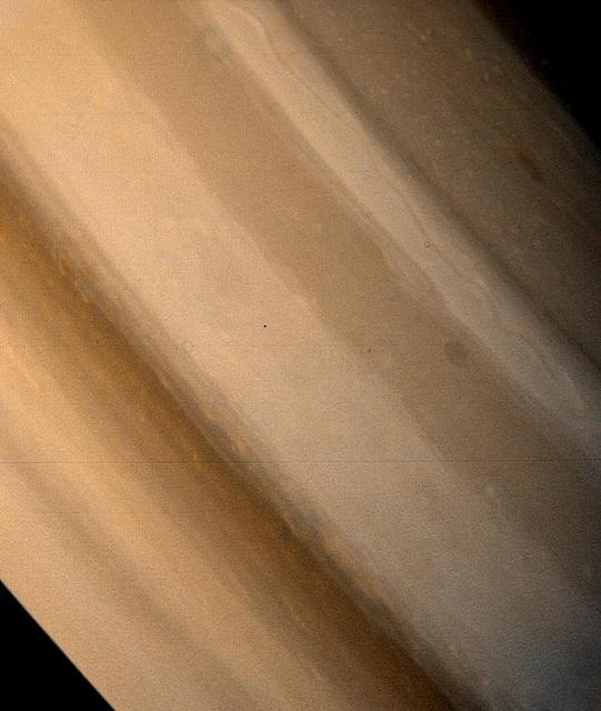
Two brown ovals, at right, some 10,000 km 6,000 miles across, were found at approximately 40 latitude in Saturn northern hemisphere by NASA Voyager 1. The photo was taken on November 7, 1980.
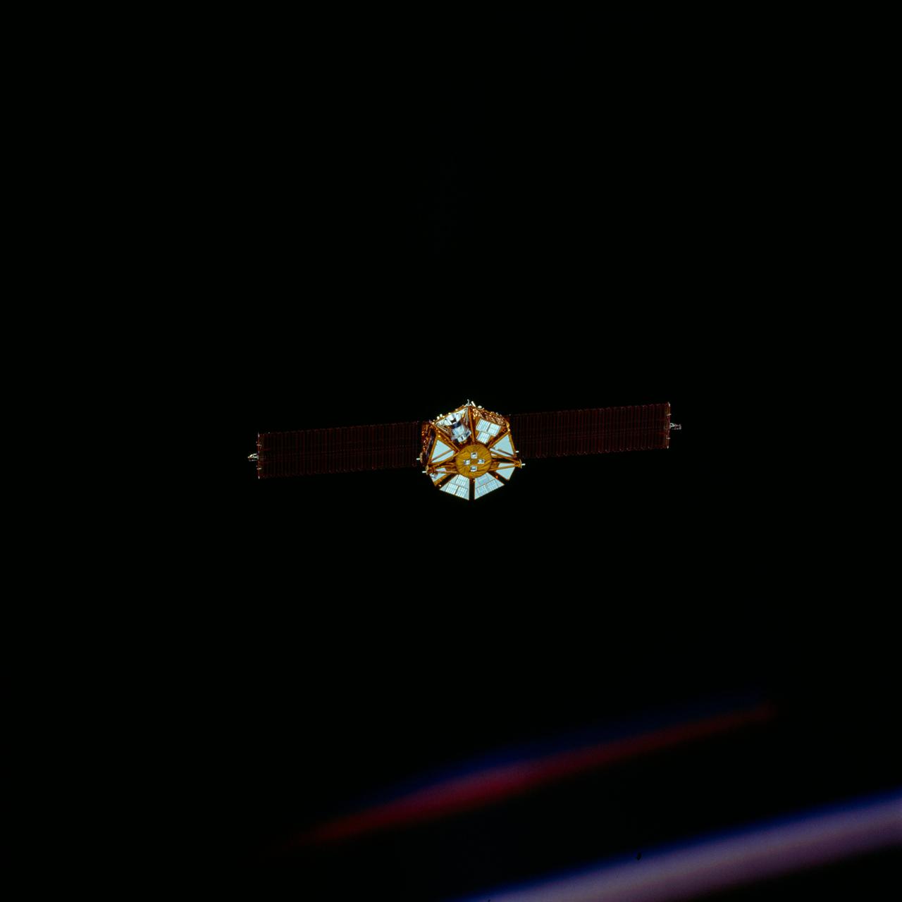
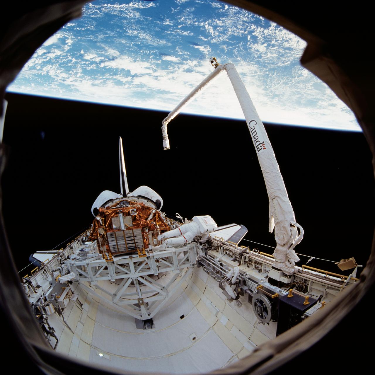
STS072-720-042 (13 Jan. 1996) --- The crew members captured this 70mm view of the Japanese Space Flyer Unit (SFU) just prior to the jettisoning of the solar panels. Later, they used the Remote Manipulator System (RMS) to latch onto the satellite and berth it in the Space Shuttle Endeavour’s aft cargo bay.
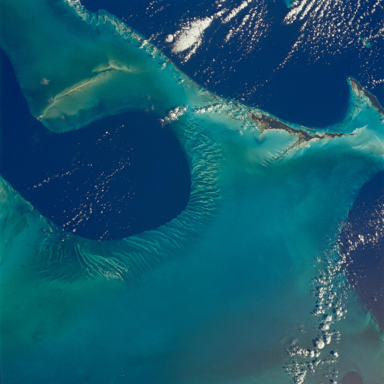
STS080-742-070 (19 Nov.-7 Dec. 1996) --- A view of the Tongue of the Ocean in the Bahama Islands east of Florida. The lines leading from the flat bottom of the Great Bahama Bank, leading into the Tongue, are caused by rapid transfer of ocean water caused by both temperature changes in the water and hurricanes that periodically cross the area. The water is about 30 feet deep on the Great Bahama Bank, and nearly a mile deep in the tongue. To the left is the Exuma Sound, over a mile deep, and a series of islands along its edge with Great Exuma Island the easiest to see. Green Cay, the small dot lower left, leaving a wake to the southeast of light colored coral. The deep blue area to the top right center is the southeastern edge of the Great Bahama Bank.
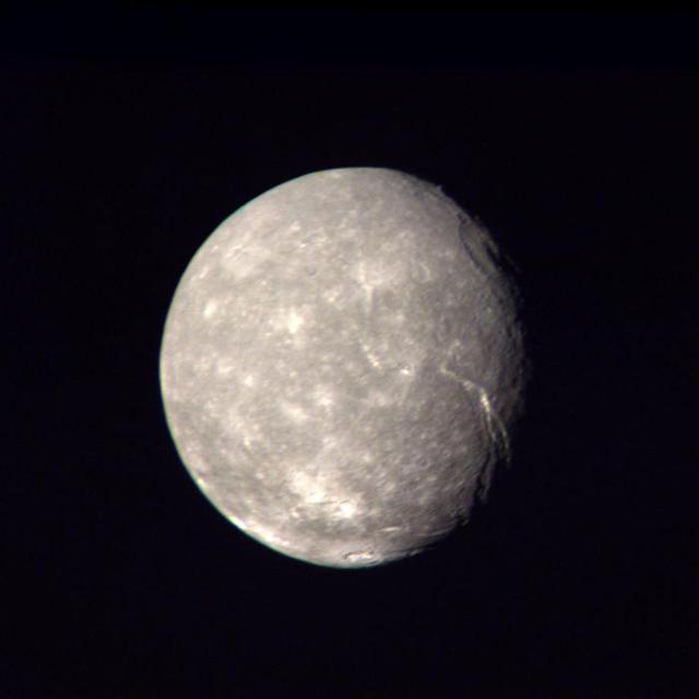
This high-resolution color composite of Titania was made from NASA Voyager 2 images taken Jan. 24, 1986, as the spacecraft neared its closest approach to Uranus. A large, trenchlike feature is seen near the terminator. http://photojournal.jpl.nasa.gov/catalog/PIA00036
STS076-461-014 (22-31 March 1996) --- Cosmonaut Yury V. Usachev, Mir-21 flight engineer, reflects on his mission duties in his living quarters aboard Russia's Mir Space Station. His temporary out-the-window scenery is provided by the nose of the Space Shuttle Atlantis, which docked with Mir on March 23, 1996.
KENNEDY SPACE CENTER, FLA. -- Atlantis rolls out to pad 39A for the second time, following threat from Hurricane Fran
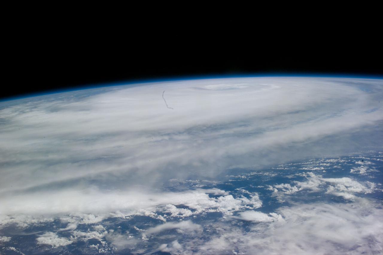
STS079-E-5100 (20 September 1996) --- The crew aboard the Space Shuttle Atlantis was able to track the large Typhoon Violet in the western Pacific Ocean. At the beginning of the mission, Violet was south and west of Japan, and packed winds of 140 - 150 miles per hour. Four days into the flight, about the time this Electronic Still Camera (ESC) view was recorded and downlinked to Earth, Violet became extra-tropical, but she still had winds up to 90 knots (nautical miles per hour).
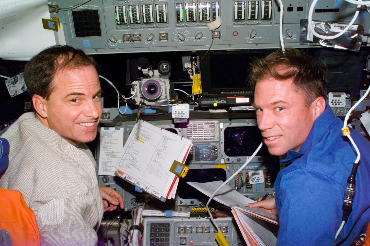
Launched on June 20, 1996, the STS-78 mission’s primary payload was the Life and Microgravity Spacelab (LMS), which was managed by the Marshall Space Flight Center (MSFC). During the 17 day space flight, the crew conducted a diverse slate of experiments divided into a mix of life science and microgravity investigations. In a manner very similar to future International Space Station operations, LMS researchers from the United States and their European counterparts shared resources such as crew time and equipment. Five space agencies (NASA/USA, European Space Agency/Europe (ESA), French Space Agency/France, Canadian Space Agency /Canada, and Italian Space Agency/Italy) along with research scientists from 10 countries worked together on the design, development and construction of the LMS. This onboard photo represents payload commander Susan Helms and fellow astronaut in the LMS.
Electronics control module for the NASA Bioreactor. The NASA Bioreactor provides a low turbulence culture environment which promotes the formation of large, three-dimensional cell clusters. The Bioreactor is rotated to provide gentle mixing of fresh and spent nutrient without inducing shear forces that would damage the cells. Due to their high level of cellular organization and specialization, samples constructed in the bioreactor more closely resemble the original tumor or tissue found in the body. The work is sponsored by NASA's Office of Biological and Physical Research. The bioreactor is managed by the Biotechnology Cell Science Program at NASA's Johnson Space Center (JSC). NASA-sponsored bioreactor research has been instrumental in helping scientists to better understand normal and cancerous tissue development. In cooperation with the medical community, the bioreactor design is being used to prepare better models of human colon, prostate, breast and ovarian tumors. Cartilage, bone marrow, heart muscle, skeletal muscle, pancreatic islet cells, liver and kidney are just a few of the normal tissues being cultured in rotating bioreactors by investigators.
Astronaut Mark Lee conducts Hubble Space Telescope training in Marshall's Neutral Buoyancy Simulator (NBS)

STS080-733-021 (19 Nov.-7 Dec. 1996) --- The crewmembers of the Earth-orbiting space shuttle Columbia took this view that shows Kuwait City (mid-center right and along the coastal area), most of Kuwait, portions of Saudi Arabia, and Iraq. Faylakah Awhah Island is seen in the Persian Gulf to the bottom right. Most of the darkened areas represent the residual from oil well fires during the Gulf War of the early 1990?s.
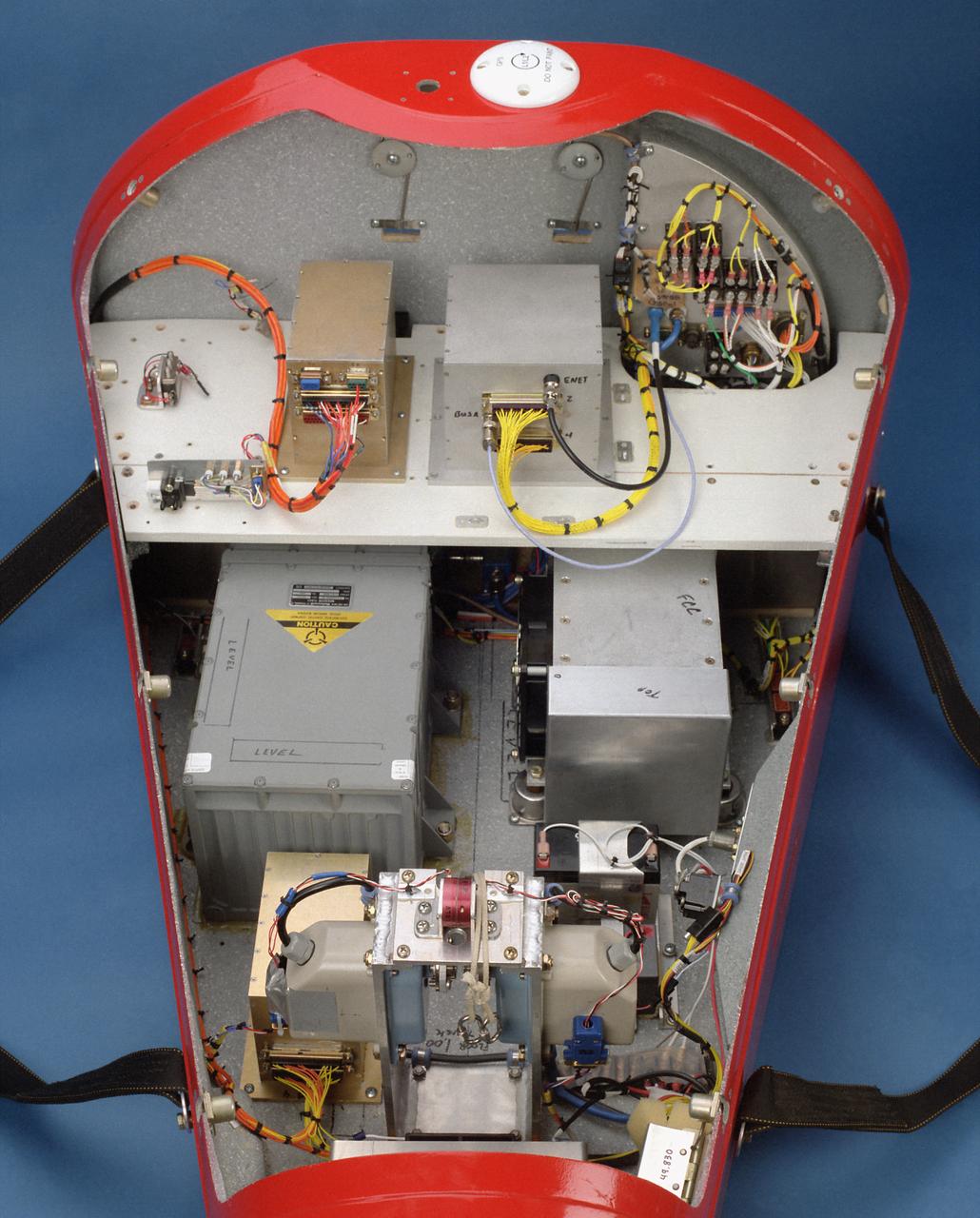
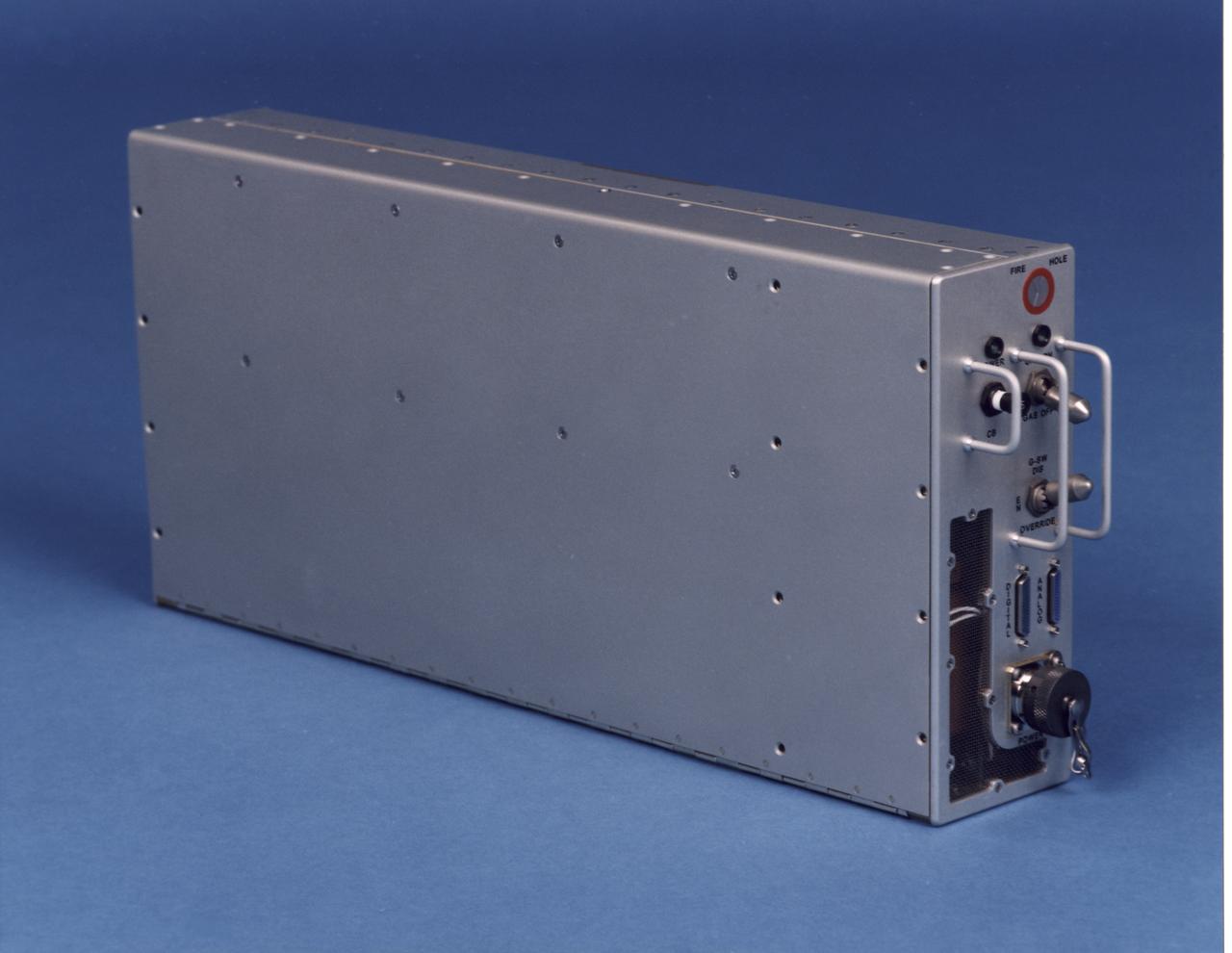
This photo shows the instrumentation and equipment inside the Spacewedge #3, a remotely-piloted research vehicle flown at the Dryden Flight Research Center, Edwards, California, to help develop technology for autonomous return systems for spacecraft as well as methods to deliver large Army cargo payloads to precise landings.
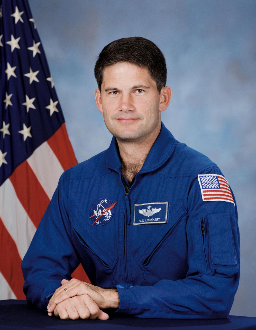
JOHNSON SPACE CENTER, HOUSTON, TX -- (JSC 596-19099) --Official Portrait of astronaut Paul S. Lockhart, pilot
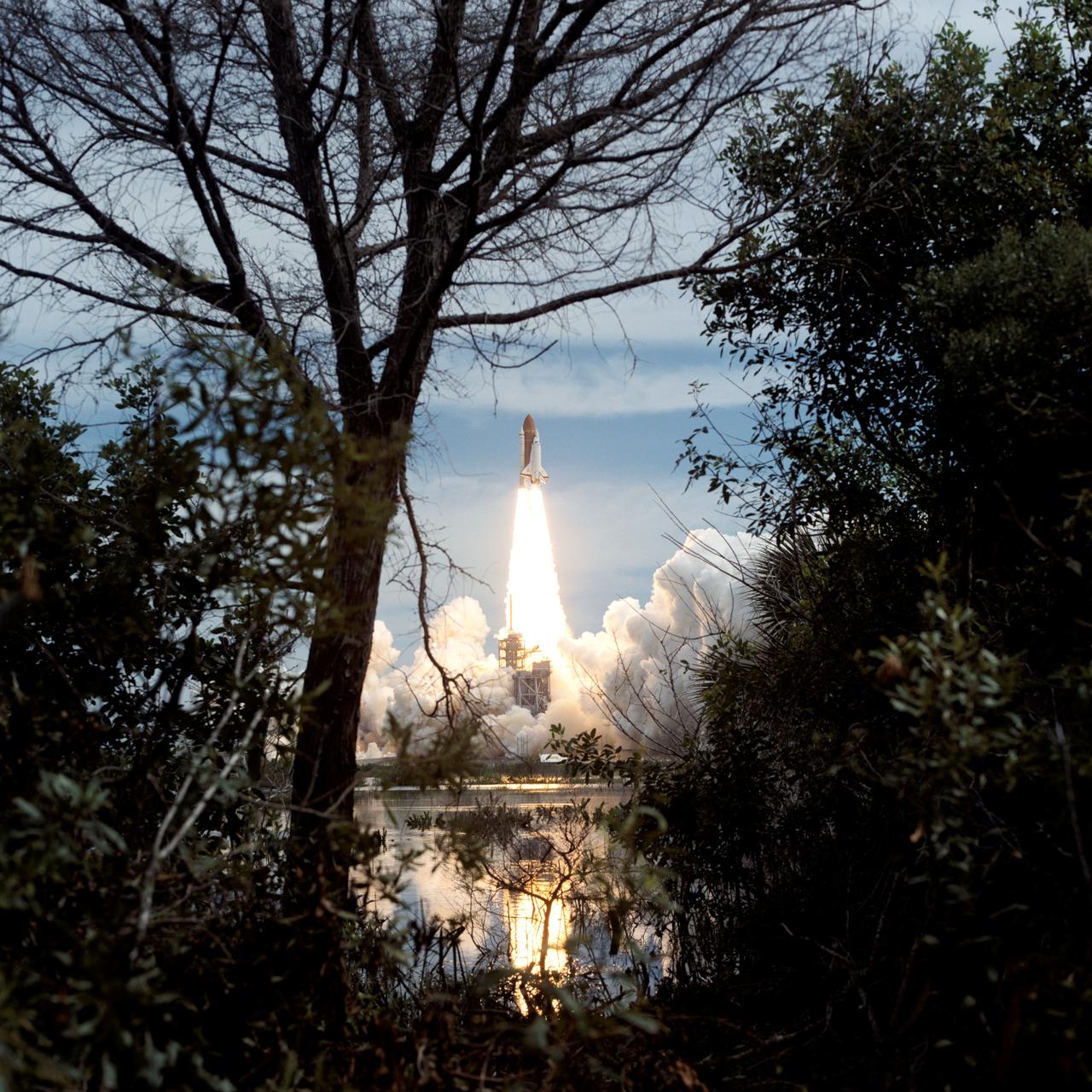
STS069-S-024 (7 September 1995) --- Trees and shrubs frame the liftoff phase of the Space Shuttle Endeavour as it begins the STS-69 mission. Liftoff from Launch Pad 39A occurred at 11:09:00:52 a.m. (EDT), September 7, 1995. The crew of five NASA astronauts is embarking on an 11-day multifaceted mission featuring two free-flying scientific research spacecraft, a spacewalk and a host of experiments in both the cargo bay and the middeck. Onboard were astronauts David M. Walker, Kenneth D. Cockrell, James S. Voss, James H. Newman and Michael L. Gernhardt.
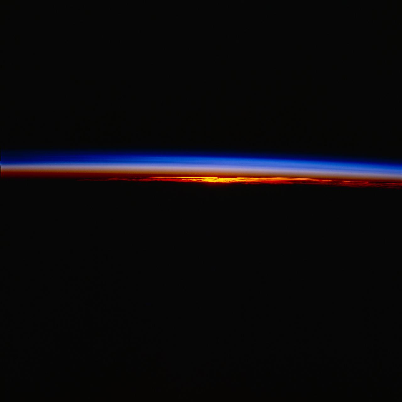
STS077-704-045 (19-29 May 1996) --- As the Space Shuttle Endeavour goes into darkness, the sun setting behind gave the astronaut crew aboard Endeavour a great chance to look at the atmospheric limb. The colors of the atmospheric limb are created by the sunlight being reflected off the gases of the upper atmosphere. As the photograph shows, the Earth?s weather and clouds take up only a small part of the whole atmosphere.
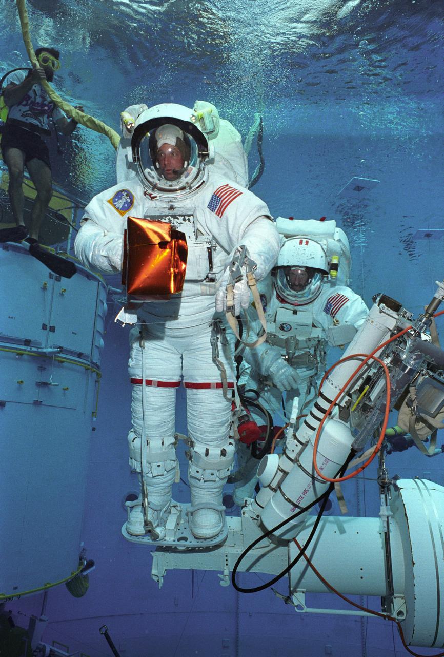
Astronauts Greg Harbaugh and Joe Tarner conduct Hubble Space Telescope training in Marshall's Neutral Buoyancy Simulator (NBS).

S96-16637 (1996) --- Portrait of Sandra Magnus, astronaut candidate, class of 1996.
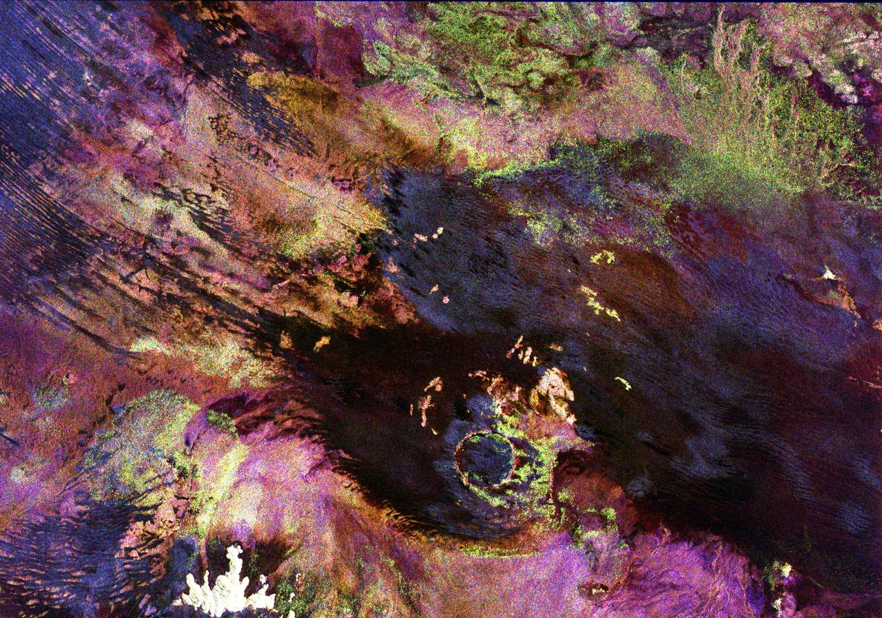
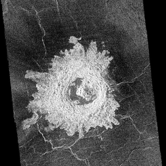
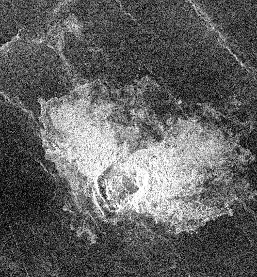
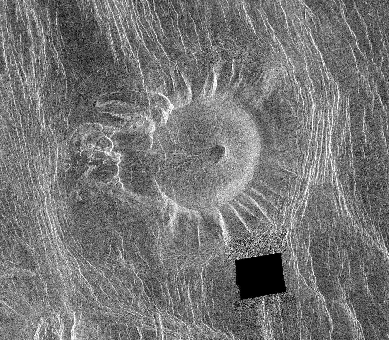
This space radar image shows the Roter Kamm impact crater in southwest Namibia. The crater rim is seen in the lower center of the image as a radar-bright, circular feature. Geologists believe the crater was formed by a meteorite that collided with Earth approximately 5 million years ago. The data were acquired by the Spaceborne Imaging Radar-C/X-Band Synthetic Aperture Radar (SIR-C/X-SAR) instrument onboard space shuttle Endeavour on April 14, 1994. The area is located at 27.8 degrees south latitude and 16.2 degrees east longitude in southern Africa. The colors in this image were obtained using the following radar channels: red represents the L-band (horizontally transmitted and received); green represents the L-band (horizontally transmitted and vertically received); and blue represents the C-band (horizontally transmitted and vertically received). The area shown is approximately 25.5 kilometers (15.8 miles) by 36.4 kilometers (22.5 miles), with north toward the lower right. The bright white irregular feature in the lower left corner is a small hill of exposed rock outcrop. Roter Kamm is a moderate sized impact crater, 2.5 kilometers (1.5 miles) in diameter rim to rim, and is 130 meters (400 feet) deep. However, its original floor is covered by sand deposits at least 100 meters (300 feet) thick. In a conventional aerial photograph, the brightly colored surfaces immediately surrounding the crater cannot be seen because they are covered by sand. The faint blue surfaces adjacent to the rim may indicate the presence of a layer of rocks ejected from the crater during the impact. The darkest areas are thick windblown sand deposits which form dunes and sand sheets. The sand surface is smooth relative to the surrounding granite and limestone rock outcrops and appears dark in radar image. The green tones are related primarily to larger vegetation growing on sand soil, and the reddish tones are associated with thinly mantled limestone outcrops. Studies of impact craters on the surface of the Earth help geologists understand the role of the impact process in the Earth's evolution, including effects on the atmosphere and on biological evolution. http://photojournal.jpl.nasa.gov/catalog/PIA00503
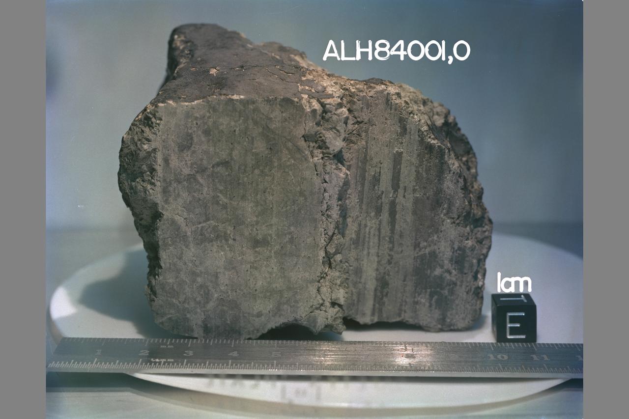
Martian Meteorite (ALH84001) Life on Mars? Microscopic Fossils
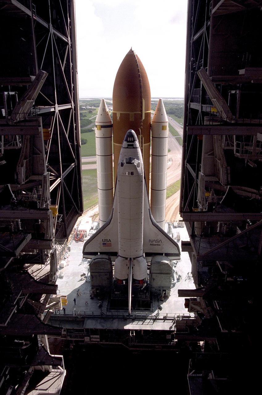
KENNEDY SPACE CENTER, FLA. -- Atlantis, with its new external tank/solid rocket booster stack, rolls out to Pad 39A on August 20, 1996, in preparation for launch of STS-79 on the fourth Mir docking mission. Atlantis will return Astronaut Shannon Lucid to Earth after her record-breaking stay by an American on the Russian space station. Lucid has completed 21 weeks in space this week. Astronaut John Blaha will trade places with Lucid for a planned four-month stay aboard Mir. Atlantis will also carry the first SPACEHAB Double Module
KSC's Press Site serves as the stage for makers of "The Cape," a pilot television movie starring Corbin Bernsen (third from front).
STS072-310-007 (11-20 Jan. 1996) --- Astronauts Brent W. Jett Jr. (left) and Koichi Wakata work with the Protein Crystal Growth (PCG) experiment at the Single Locker Thermal Enclosure System (STES) on the Space Shuttle Endeavour’s mid-deck. Jett, making his first flight in space, served as the crew’s pilot, while Wakata served as a mission specialist. Wakata, also a first time Shuttle crew member, represents Japan’s National Space Development Agency (NASDA).
STS077-352-003 (29 May 1996) --- Astronaut Curtis L. Brown, Jr., pilot, raises his helmet visor upon wheel stop of the Space Shuttle Endeavour, completing a ten-day mission. Brown and five other astronauts had spent almost ten days aboard Endeavour in support of the Spacehab 4 mission and a number of other payloads.
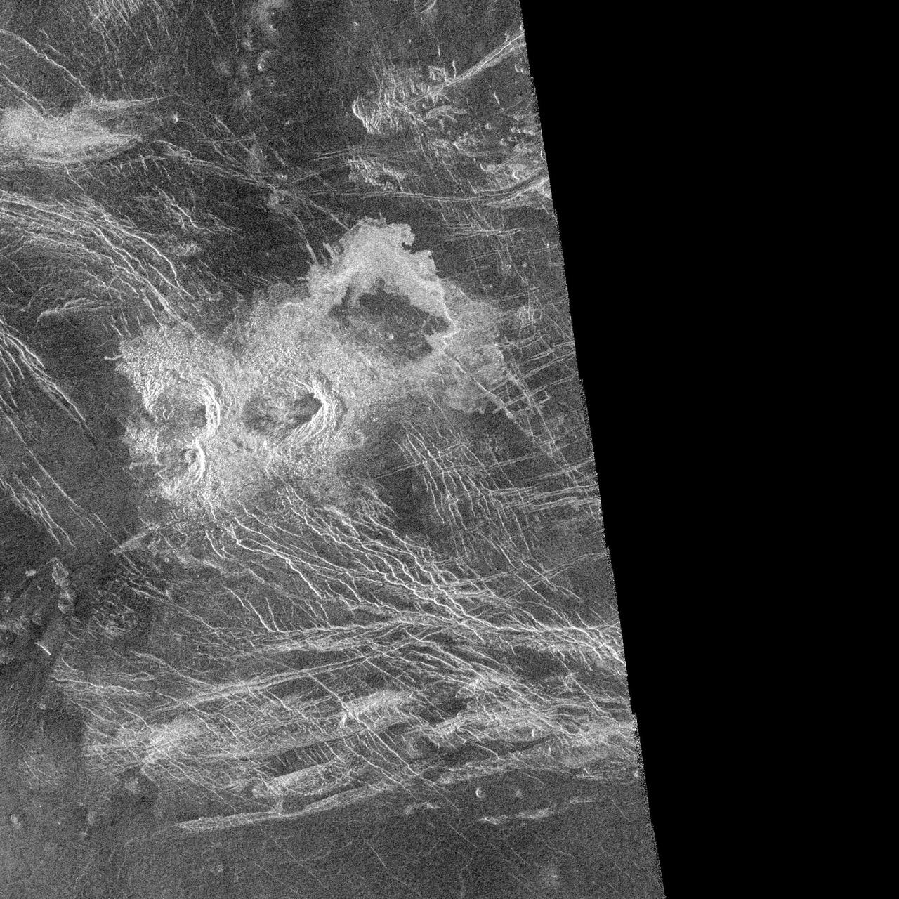
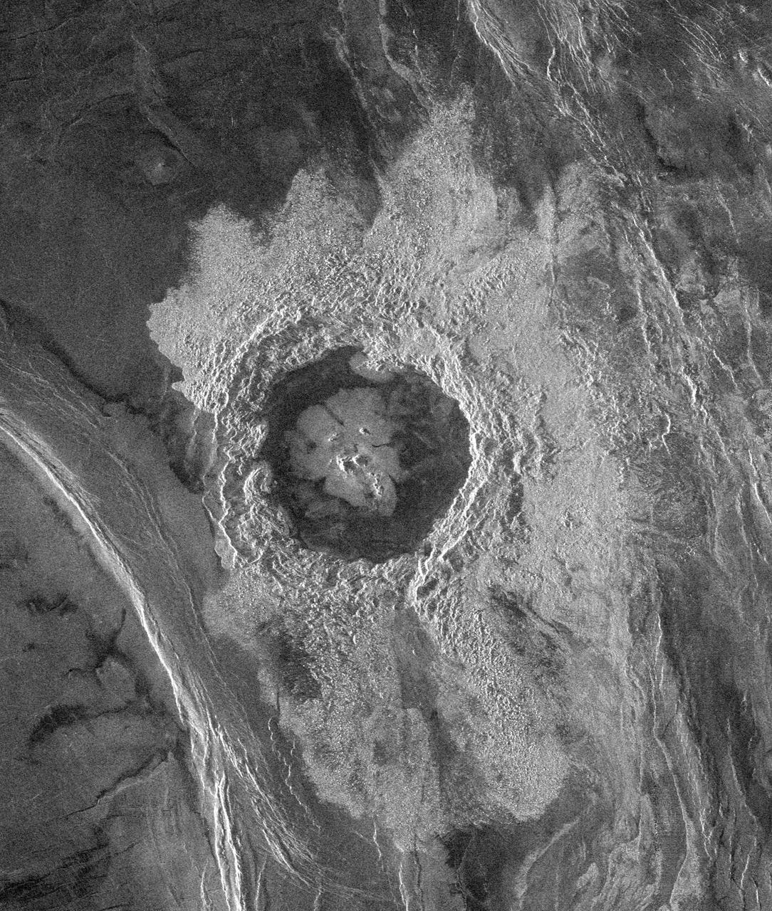
This complex crater in the Navka region of Venus was mapped by Magellan on September 26-27, 1990 during orbits 459 and 460. The crater has a diameter of 22 kilometers (13.6 miles) and is located at latitude 5.75 degrees south, longitude 349.6 degrees east. It has the terraced walls, flat radar-dark floor, and central peak that are characteristic of craters classified as 'complex.' The central peak on its floor is unusually large. Flow-like deposits extend beyond the limits of the coarser rim deposits on its west and southwest. Like about half of the craters mapped by Magellan to date, it is surrounded by a local, radar-dark halo. Buck, the proposed name for this crater honors Pearl S. Buck, American author (1892-1973). Proposed names for all features on planetary bodies are provisional until formally adopted by the International Astronomical Union. http://photojournal.jpl.nasa.gov/catalog/PIA00470
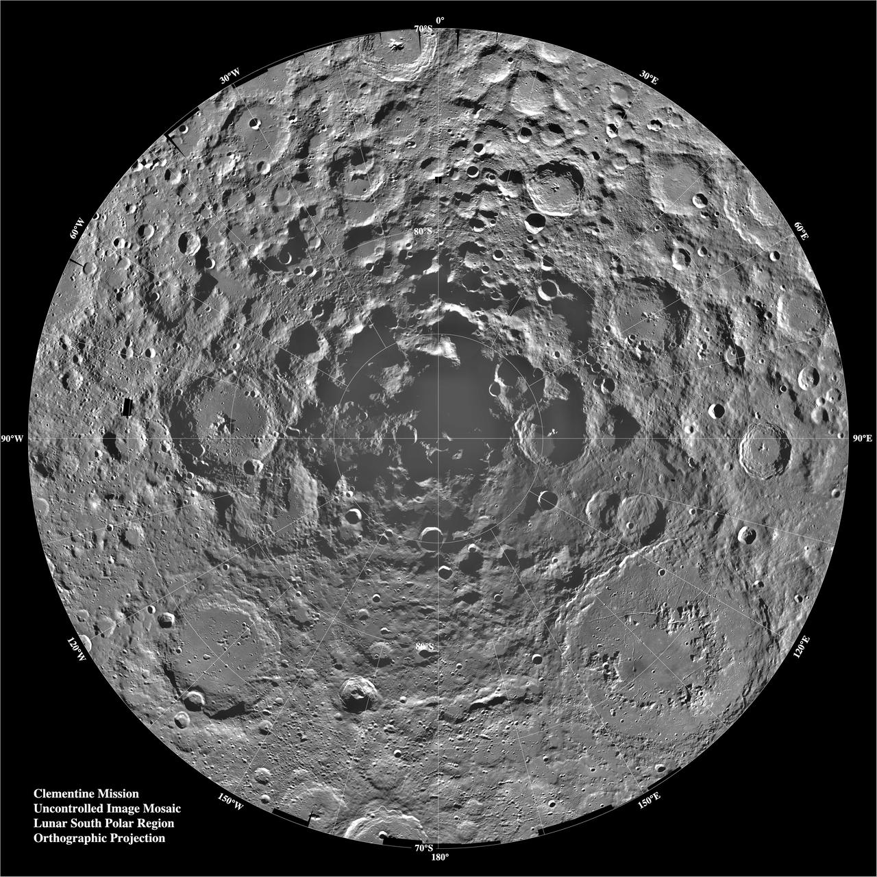
Lunar mosaic of ~1500 Clementine images of the south polar region of the moon. The projection is orthographic, centered on the south pole. The Schrodinger Basin (320 km in diameter) is located in the lower right of the mosaic. Amundsen-Ganswindt is the more subdued circular basin between Schrodinger and the pole. The polar regions of the moon are of special interest because of the postulated occurrence of ice in permanently shadowed areas. The south pole is of greater interest because the area that remains in shadow is much larger than that at the north pole. http://photojournal.jpl.nasa.gov/catalog/PIA00001

NASA's Magellan full-resolution image shows Maxwell Montes, centered at 65 degrees north latitude and 6 degrees east longitude. Maxwell is the highest mountain on Venus, rising almost 11 kilometers 6.8 miles above mean planetary radius. http://photojournal.jpl.nasa.gov/catalog/PIA00149
STS079-346-022 (16-26 Sept. 1996) --- Astronaut William F. Readdy, mission commander, looks at the night sky and Earth's horizon through a viewing port in the Spacehab Module in the space shuttle Atlantis' cargo bay. The double module version of Spacehab was flying for the first time.
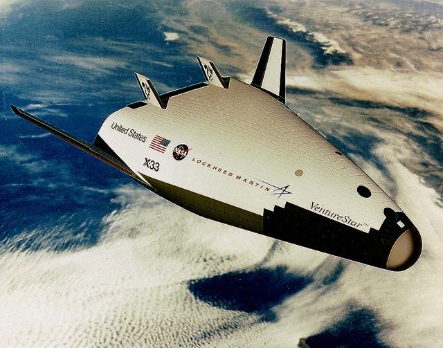
This picture is of a small scale flight demonstrator of the X-33 Reusable Launch Vehicle (RLV), Venture Star, developed and built by NASA and Lockheed Martin. The X-33 program was cancelled in 2001.

This global view from NASA's Magellan spacecraft is of the surface of Venus is centered at 180 degrees east longitude. http://photojournal.jpl.nasa.gov/catalog/PIA00104
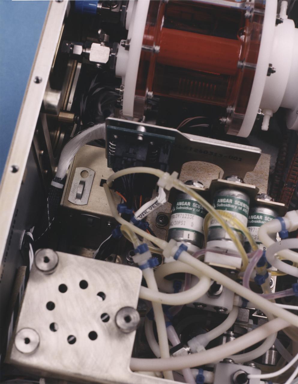
Close-up view of the interior of a NASA Bioreactor shows the plastic plumbing and valves (cylinders at right center) to control fluid flow. The rotating wall vessel is at top center. The NASA Bioreactor provides a low turbulence culture environment which promotes the formation of large, three-dimensional cell clusters. The Bioreactor is rotated to provide gentle mixing of fresh and spent nutrient without inducing shear forces that would damage the cells. Due to their high level of cellular organization and specialization, samples constructed in the bioreactor more closely resemble the original tumor or tissue found in the body. The work is sponsored by NASA's Office of Biological and Physical Research. The bioreactor is managed by the Biotechnology Cell Science Program at NASA's Johnson Space Center (JSC). NASA-sponsored bioreactor research has been instrumental in helping scientists to better understand normal and cancerous tissue development. In cooperation with the medical community, the bioreactor design is being used to prepare better models of human colon, prostate, breast and ovarian tumors. Cartilage, bone marrow, heart muscle, skeletal muscle, pancreatic islet cells, liver and kidney are just a few of the normal tissues being cultured in rotating bioreactors by investigators.
The letter 'B' or perhaps the figure '8' appears to have been etched into the Mars rock at the left edge of this picture taken yesterday by NASA's Viking 1 Lander. It is believed to be an illusion caused by weathering processes and the angle of the sun as it illuminated the scene for the spacecraft camera. The object at lower left is the housing containing the surface sampler scoop. http://photojournal.jpl.nasa.gov/catalog/PIA00386
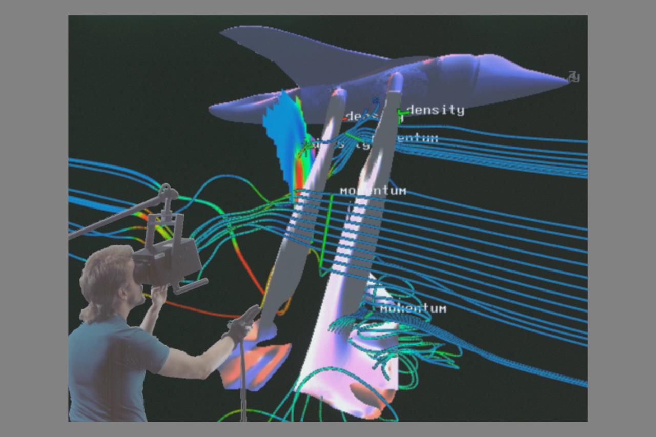
Virtual Wind Tunnel, Shuttle composite with Steve Bryson
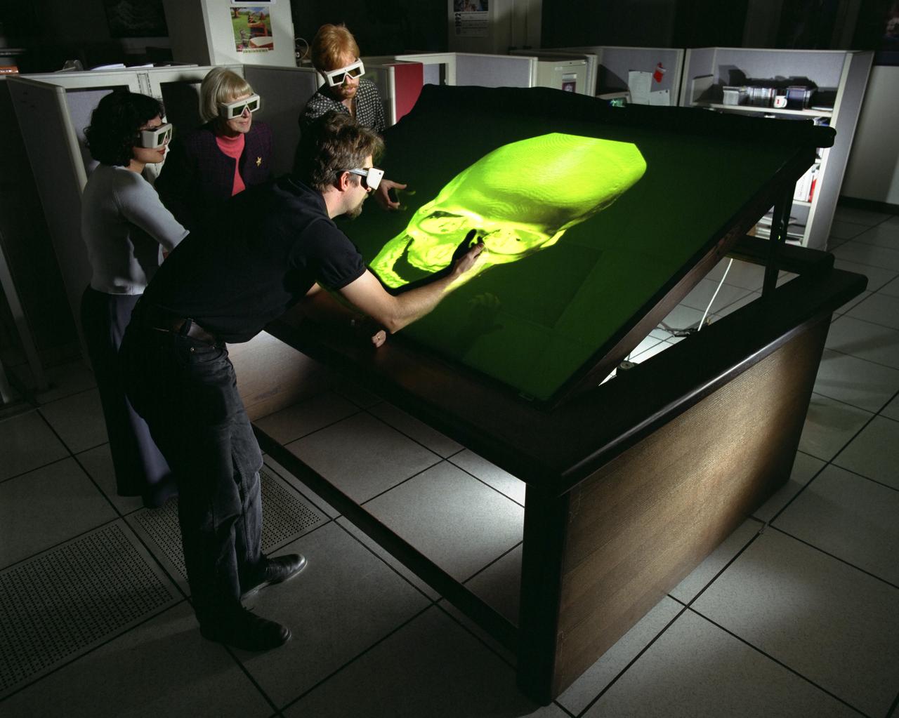
Fake Space Immersive Workbench N-239 showng skull for reconstructive surgery studies
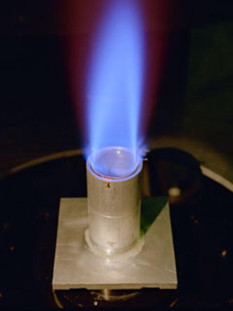
The Ring Flame Stabilizer has been developed in conjunction with Lewis Research Center. This device can lower pollutant emissions (which contribute to smog and air pollution) from natural-gas appliances such as furnaces and water heaters by 90 percent while improving energy efficiency by 2 percent.

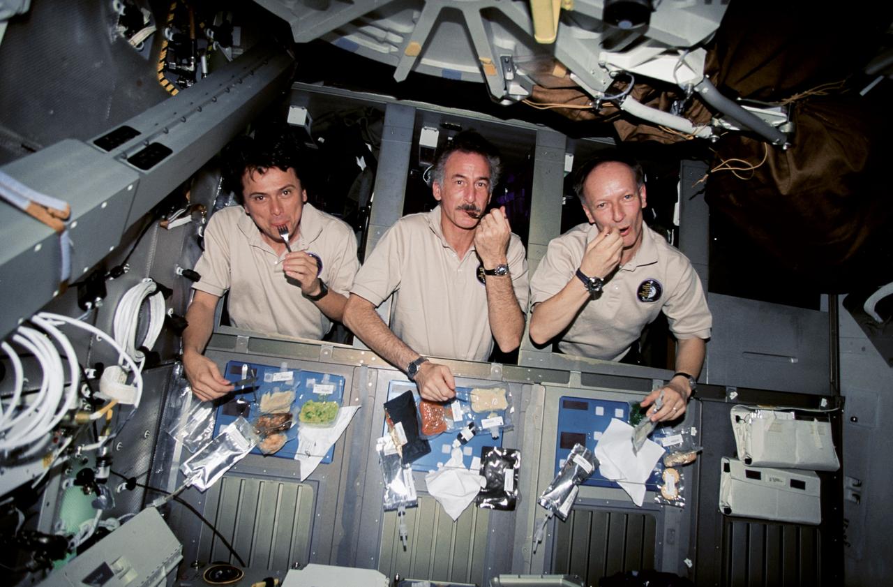
STS79-E-5240 (21 September 1996) --- Cosmonaut Valeri G. Korzun (left), Mir-22 commander, and astronaut John E. Blaha, cosmonaut guest researcher, share another mealtime on the Space Shuttle Atlantis' mid deck, during Flight Day 6.
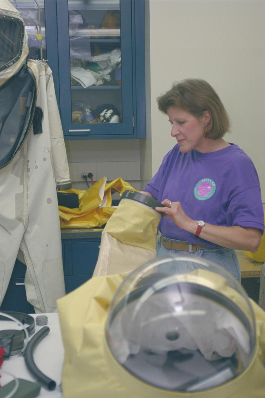
1996 'STELLAR' teacher in Space Suit Lab
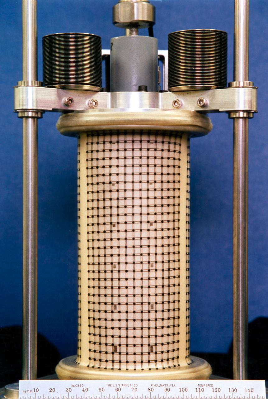
One of three Mechanics of Granular Materials (MGM) test cells after flight on STS-79 and before impregnation with resin. Note that the sand column has bulged in the middle, and that the top of the column is several inches lower than the top of the plastic enclosure. Sand and soil grains have faces that can cause friction as they roll and slide against each other, or even cause sticking and form small voids between grains. This complex behavior can cause soil to behave like a liquid under certain conditions such as earthquakes or when powders are handled in industrial processes. Mechanics of Granular Materials (MGM) experiments aboard the Space Shuttle use the microgravity of space to simulate this behavior under conditons that carnot be achieved in laboratory tests on Earth. MGM is shedding light on the behavior of fine-grain materials under low effective stresses. Applications include earthquake engineering, granular flow technologies (such as powder feed systems for pharmaceuticals and fertilizers), and terrestrial and planetary geology. Nine MGM specimens have flown on two Space Shuttle flights. Another three are scheduled to fly on STS-107. The principal investigator is Stein Sture of the University of Colorado at Boulder. Credit: University of Colorado at Boulder

Earth Moon Conjuntion image created during Galileo second flyby. http://photojournal.jpl.nasa.gov/catalog/PIA00134
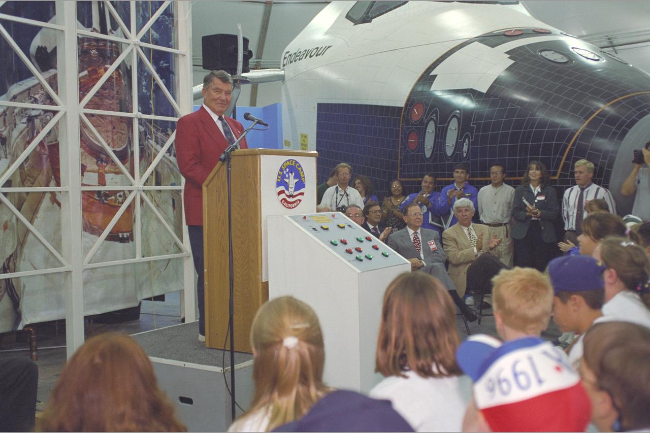
U.S. Space Camp California 'Day Camp' Grand Opening with speaker Astronaut Wally Schirra
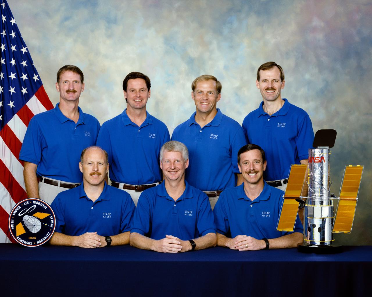
STS082-S-002 (December 1996) --- These seven astronauts are prime crew members for NASA’s STS-82 mission. They are, on the front row, from the left, Kenneth D. Bowersox, Steven A. Hawley and Scott J. Horowitz. On the back row are Joseph R. Tanner, Gregory J. Harbaugh; Mark C. Lee and Steven L. Smith. Bowersox and Horowitz are commander and pilot, respectively, with Lee assigned as payload commander. Hawley, Harbaugh, Smith and Tanner are mission specialists. The seven are pictured with a small model of the Hubble Space Telescope (HST), which they will be paying a visit representing the second HST maintenance mission. Bowersox was pilot for the STS-61 mission, which performed the first maintenance on HST. Hawley was a mission specialist on STS-31, the mission whose astronauts originally deployed the HST.

Portrait of Marshall's eighth Center Director Dr. Jerroll W. Littles (1996-1998). During the two short years as Center Director, Dr. Littles' administration was responsible for the space lab mission, the space science projects, alternative light-weight launch vehicles and their engine development.
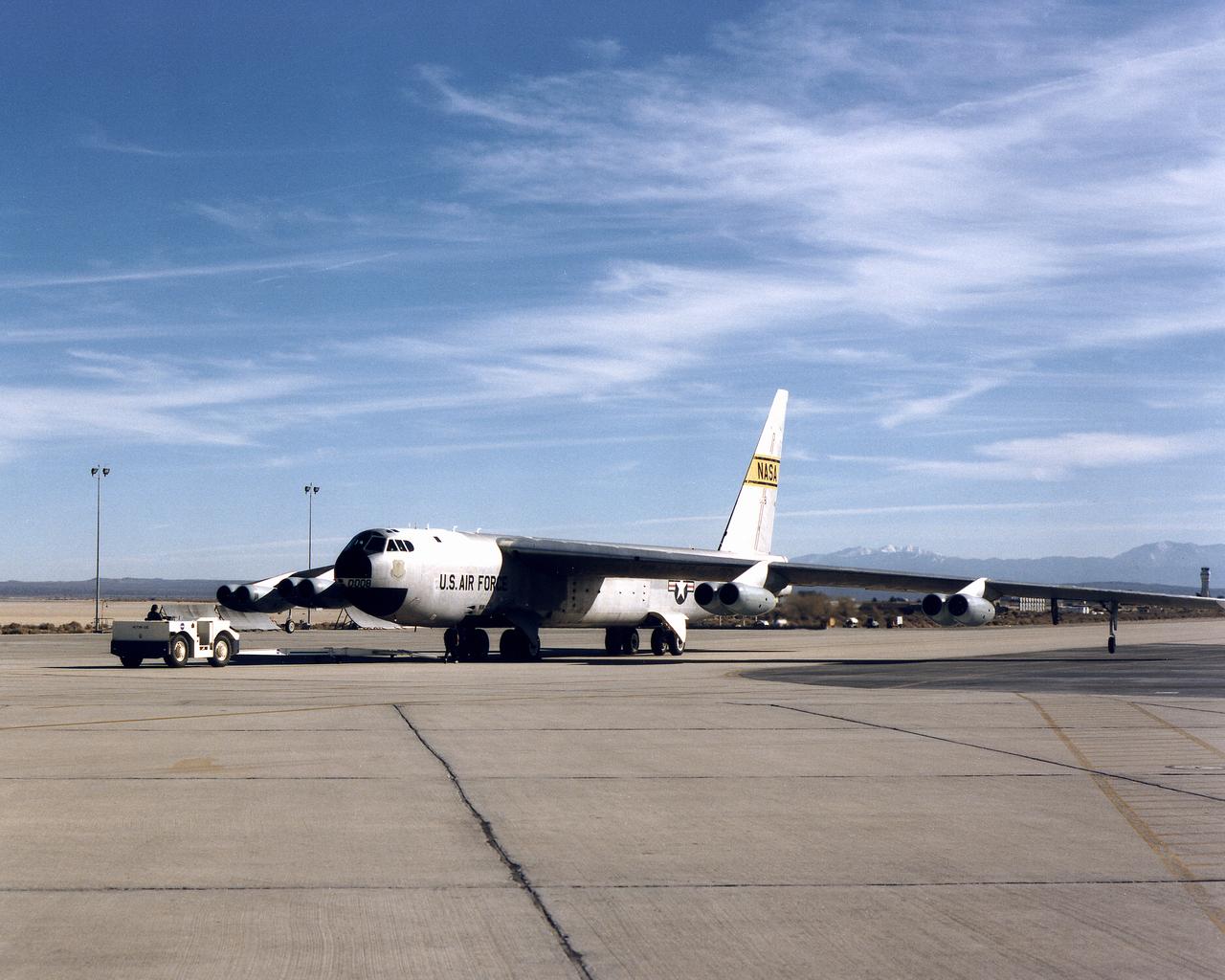
Dryden B-52 Launch Aircraft on Dryden Ramp
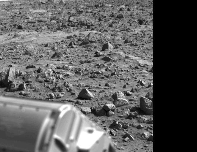
![This is the first photograph ever taken on the surface of the planet Mars. It was obtained by Viking 1 just minutes after the spacecraft landed successfully early today [July 20, 1976]. The center of the image is about 1.4 meters (five feet) from Viking Lander camera #2. We see both rocks and finely granulated material--sand or dust. Many of the small foreground rocks are flat with angular facets. Several larger rocks exhibit irregular surfaces with pits and the large rock at top left shows intersecting linear cracks. Extending from that rock toward the camera is a vertical linear dark band which may be due to a one-minute partial obscuration of the landscape due to clouds or dust intervening between the sun and the surface. Associated with several of the rocks are apparent signs of wind transport of granular material. The large rock in the center is about 10 centimeters (4 inches) across and shows three rough facets. To its lower right is a rock near a smooth portion of the Martian surface probably composed of very fine-grained material. It is possible that the rock was moved during Viking 1 descent maneuvers, revealing the finer-grained basement substratum; or that the fine-grained material has accumulated adjacent to the rock. There are a number of other furrows and depressions and places with fine-grained material elsewhere in the picture. At right is a portion of footpad #2. Small quantities of fine grained sand and dust are seen at the center of the footpad near the strut and were deposited at landing. The shadow to the left of the footpad clearly exhibits detail, due to scattering of light either from the Martian atmosphere or from the spacecraft, observable because the Martian sky scatters light into shadowed areas. http://photojournal.jpl.nasa.gov/catalog/PIA00381](https://images-assets.nasa.gov/image/PIA00381/PIA00381~thumb.jpg)
This is the first photograph ever taken on the surface of the planet Mars. It was obtained by Viking 1 just minutes after the spacecraft landed successfully early today [July 20, 1976]. The center of the image is about 1.4 meters (five feet) from Viking Lander camera #2. We see both rocks and finely granulated material--sand or dust. Many of the small foreground rocks are flat with angular facets. Several larger rocks exhibit irregular surfaces with pits and the large rock at top left shows intersecting linear cracks. Extending from that rock toward the camera is a vertical linear dark band which may be due to a one-minute partial obscuration of the landscape due to clouds or dust intervening between the sun and the surface. Associated with several of the rocks are apparent signs of wind transport of granular material. The large rock in the center is about 10 centimeters (4 inches) across and shows three rough facets. To its lower right is a rock near a smooth portion of the Martian surface probably composed of very fine-grained material. It is possible that the rock was moved during Viking 1 descent maneuvers, revealing the finer-grained basement substratum; or that the fine-grained material has accumulated adjacent to the rock. There are a number of other furrows and depressions and places with fine-grained material elsewhere in the picture. At right is a portion of footpad #2. Small quantities of fine grained sand and dust are seen at the center of the footpad near the strut and were deposited at landing. The shadow to the left of the footpad clearly exhibits detail, due to scattering of light either from the Martian atmosphere or from the spacecraft, observable because the Martian sky scatters light into shadowed areas. http://photojournal.jpl.nasa.gov/catalog/PIA00381
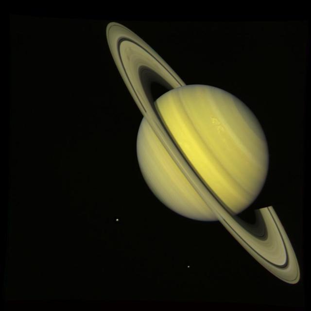
NASA Voyager 2 took this true color photograph of Saturn on July 21, 1981. The moons Rhea and Dione appear as blue dots to the south and southeast of Saturn, respectively.
This Magellan image, which is 50 kilometers (31 miles) in width and 80 kilometers (50 miles) in length, is centered at 11.9 degrees latitude, 352 degrees longitude in the eastern Navka Region of Venus. The crater, which is approximately 8 kilometers (5 miles) in diameter, displays a butterfly symmetry pattern. The ejecta pattern most likely results from an oblique impact, where the impactor came from the south and ejected material to the north. http://photojournal.jpl.nasa.gov/catalog/PIA00474
STS79-E-5018 (17 September 1996) --- Astronaut Jerome (Jay) Apt prepares experiment, a rod-like device for insertion into Extreme Temperature Translation Furnace (ETTF) in STS-79-E-5019, during early mission chores aboard Spacehab in the Space Shuttle Atlantis cargo bay, on Flight Day 2.
U.S. Space Camp California 'Day Camp' Grand Opening kids discover shuttle hatch
STS079-379-022 (16-26 Sept. 1996) --- If this moonlit picture is held with the Space Shuttle Atlantis' Orbital Maneuvering System (OMS) pods at top, a greenish aurora appears at left edge. Thanks to a time exposure on a 35mm camera, a crew member was able to capture the phenomenon visually experienced frequently by Shuttle crews. Several stars can be seen in the picture. Many of them appear closer to the camera than Earth because they are seen through the thin line of atmosphere above Earth's horizon.
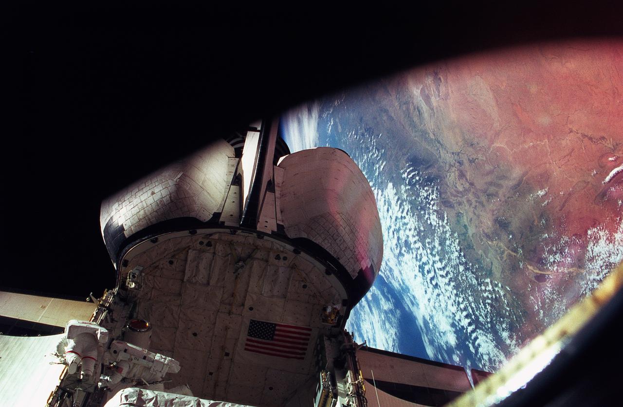
STS076-401-021 (27 March 1996) --- Astronauts Michael R. (Rich) Clifford (right) and Linda M. Godwin (red stripe) work together on the port side of the Space Shuttle Atlantis' aft cargo bay during a March 27, 1996, Extravehicular Activity (EVA). The Atlas Mountains can been seen near Earth's horizon in the background. The EVA of the two mission specialists marks the first EVA while Russia's Mir Space Station was docked with the Space Shuttle Atlantis. This is the third of a series of docking missions involving Mir and the Space Shuttle Atlantis.
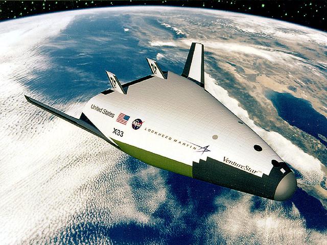
In this artist's concept, the X-33 Venture Star, a Reusable Launch Vehicle (RLV), manufactured by Lockheed Martin Skunk Works, is shown in orbit with a deployed payload. The Venture Star was one of the earliest versions of the RLV's developed to replace the aging shuttle fleet. The X-33 program was cancelled in 2001.
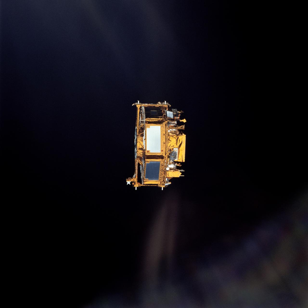
STS072-720-076 (13 Jan. 1996) --- The crewmembers captured this 35mm view of the Japanese Space Flyer Unit (SFU) following the jettisoning of the solar panels. Later they used the Remote Manipulator System (RMS) to latch onto the satellite and berth it in the Space Shuttle Endeavour's aft cargo bay.
NASA Magellan synthetic aperture radar SAR imaged this unique triplet crater, or crater field during orbits 418-421 on Sept. 21, 1990. The three craters appear to have relatively steep walls. http://photojournal.jpl.nasa.gov/catalog/PIA00088
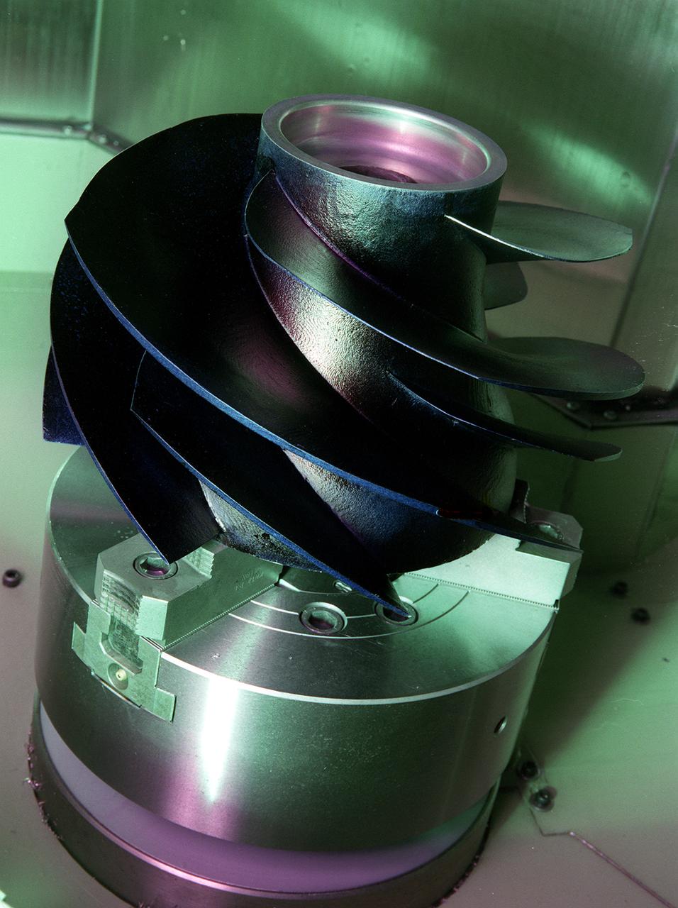
Marshall space Flight Center engineers helped North American Marine Jet (NAMJ), Inc. improve the proposed design of a new impeller for a jet-propulsion system. With a three-dimensional computer model of the new marine jet engine blades, engineers were able to quickly create a solid polycarbonate model of it. The rapid prototyping allowed the company to avoid many time-consuming and costly steps in creating the impeller.
S76-E-5138 (24 March 1996) --- Astronauts Kevin P. Chilton (left) and Richard A. Searfoss man the commander and pilot stations, respectively, for the rendezvous and docking procedures with Russia's Mir Space Station. The image was recorded with a 35mm Electronic Still Camera (ESC) and downlinked at a later time to ground controllers in Houston, Texas.
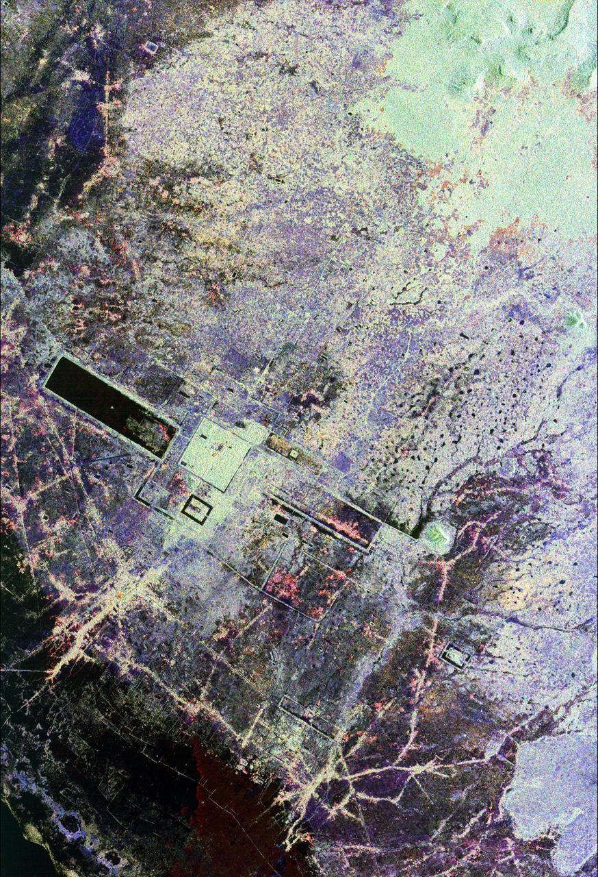
This is an image of the area around the city of Angkor, Cambodia. The city houses an ancient complex of more than 60 temples dating back to the 9th century. The principal complex, Angkor Wat, is the bright square just left of the center of the image. It is surrounded by a reservoir that appears in this image as a thick black line. The larger bright square above Angkor Wat is another temple complex called Angkor Thom. Archeologists studying this image believe the blue-purple area slightly north of Angkor Thom may be previously undiscovered structures. In the lower right is a bright rectangle surrounded by a dark reservoir, which houses the temple complex Chau Srei Vibol. In its heyday, Angkor had a population of 1 million residents and was the spiritual center for the Khmer people until it was abandoned in the 15th century. The image was acquired by the Spaceborne Imaging Radar-C/X-band Synthetic Aperture Radar (SIR-C/X-SAR) on the 15th orbit of the space shuttle Endeavour on September 30, 1994. The image shows an area approximately 55 kilometers by 85 kilometers (34 miles by 53 miles) that is centered at 13.43 degrees north latitude and 103.9 degrees east longitude. The colors in this image were obtained using the following radar channels: red represents the L-band (horizontally transmitted and received); green represents the L-band (horizontally transmitted and vertically received); blue represents the C-band (horizontally transmitted and vertically received). The body of water in the south-southwest corner is Tonle Sap, Cambodia's great central lake. The urban area at the lower left of the image is the present-day town of Siem Reap. The adjoining lines are both modern and ancient roads and the remains of Angkor's vast canal system that was used for both irrigation and transportation. The large black rectangles are ancient reservoirs. Today the Angkor complex is hidden beneath a dense rainforest canopy, making it difficult for researchers on the ground to study the ancient city. The SIR-C/X-SAR data are being used by archaeologists at the World Monuments Fund and the Royal Angkor Foundation to understand how the city grew, flourished and later fell into disuse over an 800-year period. The data are also being used to help reconstruct the vast system of hydrological works, canals and reservoirs, which have gone out of use over time. Research teams from more than 11 countries will be using this data to study the Angkor complex. http://photojournal.jpl.nasa.gov/catalog/PIA00505

In this image from NASA's Voyager wide-angle taken on Aug. 23 1989, the two main rings of Neptune can be clearly seen. In the lower part of the frame the originally announced ring arc, consisting of three distinct features, is visible. This feature covers about 35 degrees of longitude and has yet to be radially resolved in Voyager images. From higher resolution images it is known that this region contains much more material than the diffuse belts seen elsewhere in its orbit, which seem to encircle the planet. This is consistent with the fact that ground-based observations of stellar occultations by the rings show them to be very broken and clumpy. The more sensitive wide-angle camera is revealing more widely distributed but fainter material. Each of these rings of material lies just outside of the orbit of a newly discovered moon. One of these moons, 1989N2, may be seen in the upper right corner. The moon is streaked by its orbital motion, whereas the stars in the frame are less smeared. The dark area around the bright moon and star are artifacts of the processing required to bring out the faint rings. This wide-angle image was taken from a range of 2 million kilometers (1.2 million miles), through the clear filter. http://photojournal.jpl.nasa.gov/catalog/PIA00053

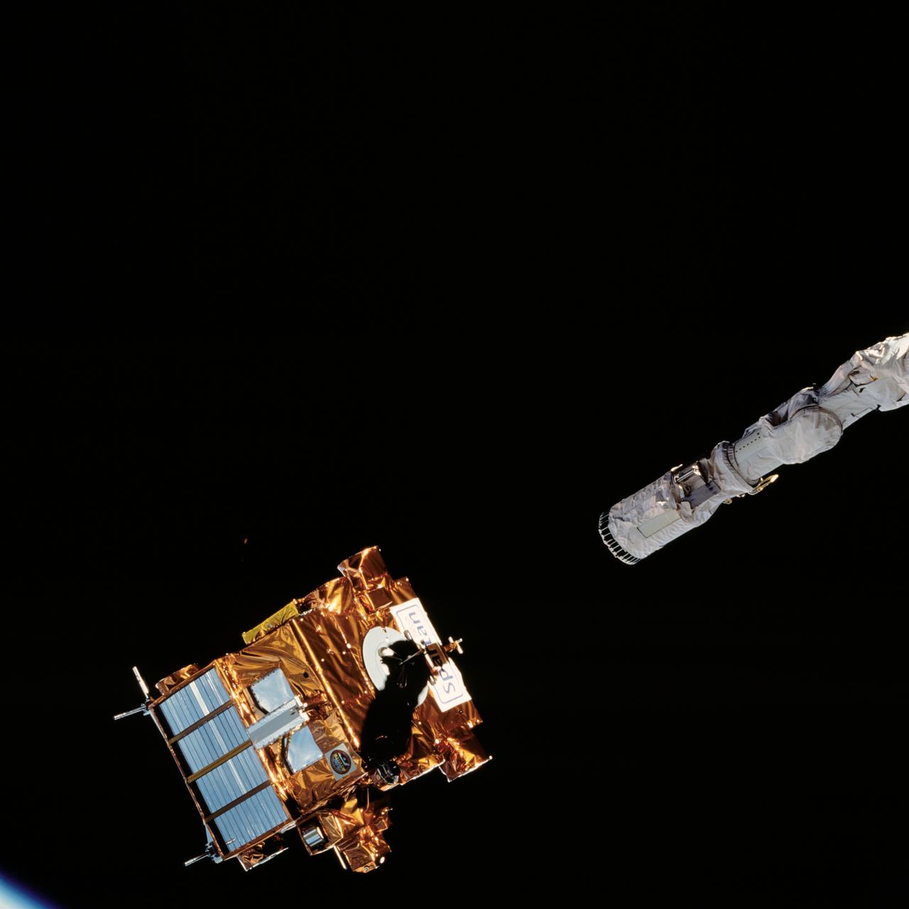
S77-E-5065 (21 May 1996) --- With a cloudy horizon scene as a backdrop, the Spartan 207 free-flyer is held in the grasp of the Space Shuttle Endeavour's Remote Manipulator System (RMS) following its re-capture on May 21, 1996. The view was captured with an onboard Electronic Still Camera (ESC). The six-member crew has spent a portion of the early stages of the mission in various activities involving the Spartan 207 and the related Inflatable Antenna Experiment (IAE). The Spartan project is managed by NASA's Goddard Space Flight Center (GSFC) for NASA's Office of Space Science, Washington, D.C.
N-227 Unitary Plan Wind Tunnel Modification Project - diffuser & contraction vanes

These images of the Venus clouds were taken by NASA Galileo Solid State Imaging System February 13,1990, at a range of about 1 million miles. The smallest detail visible is about 20 miles. They show the state of the clouds near the top of Venus cloud. http://photojournal.jpl.nasa.gov/catalog/PIA00071
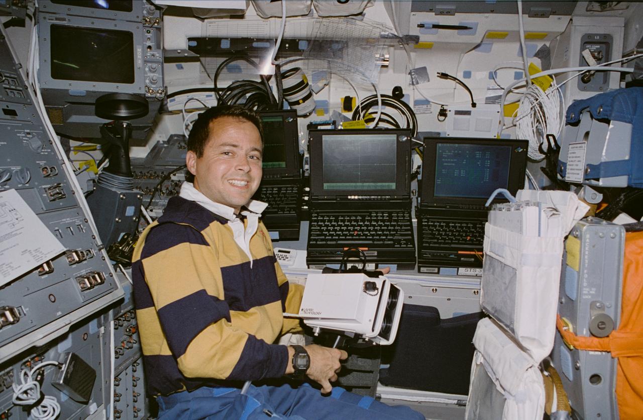
STS077-345-033 (19-29 May 1996) --- Astronaut Daniel W. Bursch, mission specialist, poses with some of the onboard hardware that kept him busy during the almost 10-day mission onboard the Space Shuttle Endeavour. He holds a handheld laser device that was used in the record number of rendezvous and station keeping operations with various free-flying payloads. Three Payload General Purpose Computers (PGPC) align the port side of the flight deck.
XV-15 Rotor Test Apparatus (RTA) flow visualization Hover test-80-0021 in 80x120ft w.t. (rotor tip)

STS072-727-085 (11-20 Jan. 1996) --- The northern third of the Great Barrier Reef stretches 650 kilometers (km) along the coast of Queensland from south of Cairns to past Princess Charlotte Bay at the base of the Cape York Peninsula. The predominant westerly waves of the ocean create shallower (lighter-colored) convex-eastward rims to coral atolls along the outer edge of the barrier reef. In contrast, islands within the lagoon show the effect of predominant southerly, more-or-less offshore winds. Arcuate clouds suggest that winds were offshore at the time the photograph was taken.
STS072-726-051 (15 Jan. 1996) --- The Office of Aeronautics and Space Technology (OAST) Flyer satellite begins its period of free flight, as it is let go by the end effector of the Space Shuttle Endeavour's Remote Manipulator System (RMS). The crewmembers retrieved the satellite two days later.
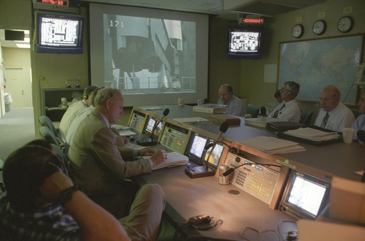
Launched on June 20, 1996, the STS-78 mission’s primary payload was the Life and Microgravity Spacelab (LMS), which was managed by the Marshall Space Flight Center (MSFC). During the 17 day space flight, the crew conducted a diverse slate of experiments divided into a mix of life science and microgravity investigations. In a manner very similar to future International Space Station operations, LMS researchers from the United States and their European counterparts shared resources such as crew time and equipment. Five space agencies (NASA/USA, European Space Agency/Europe (ESA), French Space Agency/France, Canadian Space Agency /Canada, and Italian Space Agency/Italy) along with research scientists from 10 countries worked together on the design, development and construction of the LMS. This photo was taken in the Shuttle Action Center (SAC) of the Huntsville Operations Support Center (HOSC) Spacelab Payload Operations Control Center (SL POCC) at MSFC during the mission.
STS072-722-041 (17 Jan. 1996) --- Astronaut Winston E. Scott traverses the portside of the Space Shuttle Endeavour's cargo bay during the second of two Extravehicular Activities (EVA) to demonstrate space station assembly techniques. A 30mm lens on a 70mm handheld camera gives a "fish-eye" effect to the scene. Both the Japanese Space Flyer Unit (SFU) and the Office of Aeronautics and Space Technology (OAST) Flyer satellite are in their stowed positions. TV cameras on the Remote Manipulator System (RMS) provided live coverage of the activity.
MD-900 (N900MH) Helicopter Noise Abatement Test - Crows Landing, Microphones
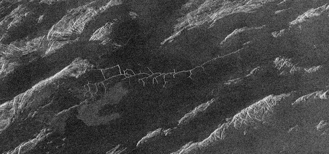
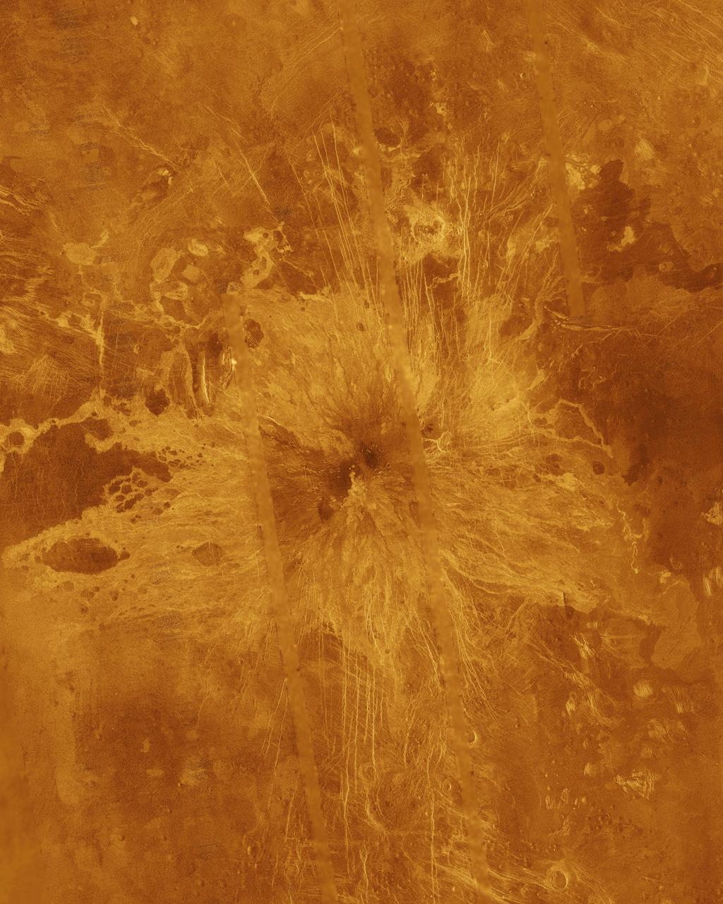
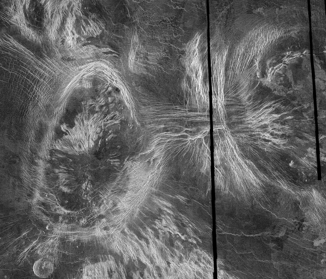
This image from NASA Magellan spacecraft covers region near Hestia Rupes on the northwestern corner of Aphrodite Terra. The complex network of narrow (<1 kilometer) fractures in the center of the image extends for approximately 50 kilometers (31 miles). This network exhibits tributary-like branches similar to those observed in river systems on Earth. However, the angular intersections of tributaries suggest tectonic control. These features appear to be due to drainage of lava along preexisting fractures and subsequent collapse of the surface. The underlying tectonic fabric can be observed in the northeast trending ridges which predate the plains. http://photojournal.jpl.nasa.gov/catalog/PIA00469
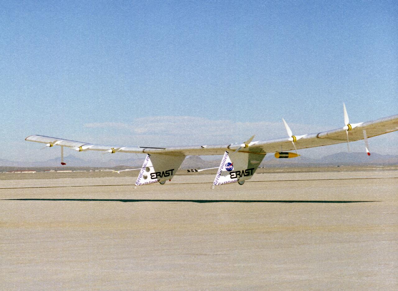
The Pathfinder solar-powered research aircraft settles in for landing on the bed of Rogers Dry Lake at the Dryden Flight Research Center, Edwards, California, after a successful test flight Nov. 19, 1996. The ultra-light craft flew a racetrack pattern at low altitudes over the flight test area for two hours while project engineers checked out various systems and sensors on the uninhabited aircraft. The Pathfinder was controlled by two pilots, one in a mobile control unit which followed the craft, the other in a stationary control station. Pathfinder, developed by AeroVironment, Inc., is one of several designs being evaluated under NASA's Environmental Research Aircraft and Sensor Technology (ERAST) program.
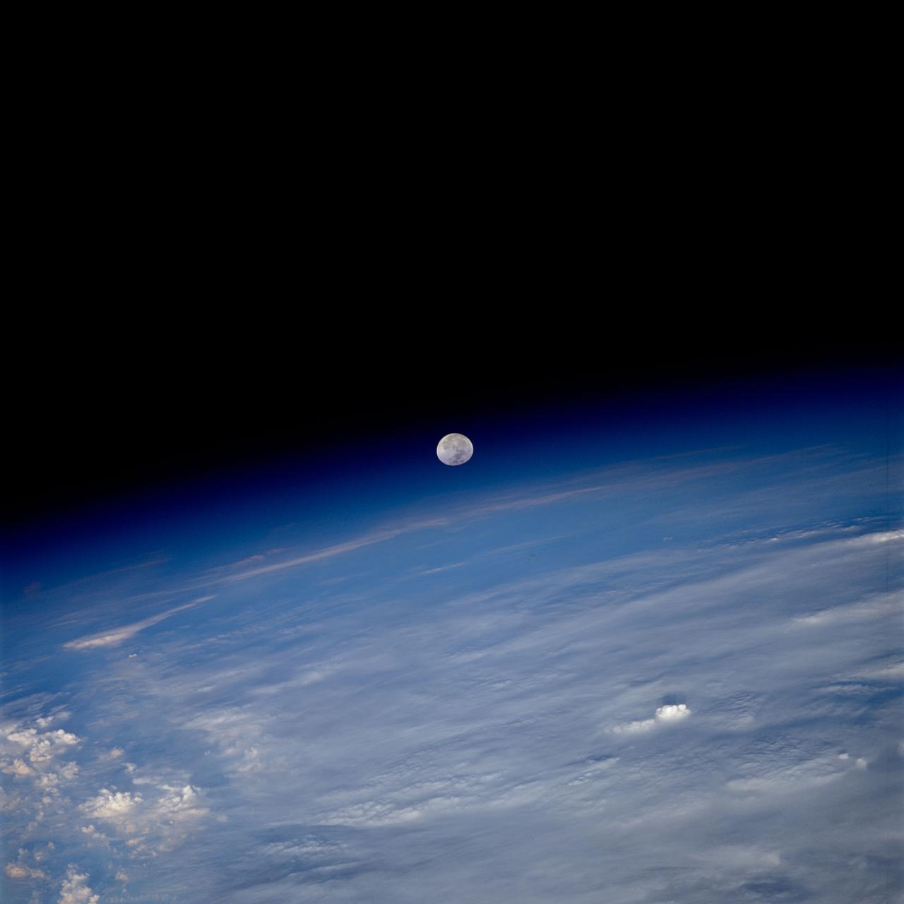
STS080-759-038 (19 Nov.-7 Dec. 1996) --- As photographed by the crewmembers aboard the space shuttle Columbia, a full moon is about to set beyond the limb of Earth. A full moon should be round but when it is near the limb, or edge of Earth, the atmosphere tends to distort the shape. The atmosphere, stratosphere, ionosphere is in reality acting as a lens, thus the distorted shape of the Moon. As the Moon reaches the Earth's horizon it will become "eggshaped".

Nereid, the last satellite of Neptune to be discovered before NASA Voyager's recent discoveries, was first seen by Gerard Kuiper in 1949. Until this Voyager 2 image was obtained, all that was known about Nereid was its orbital parameters and intrinsic brightness. This Voyager view of Nereid was obtained on Aug. 24, 1989 at a distance of 4.7 million kilometers (2.9 million miles). With a resolution of 43 kilometers (26.6 miles) per pixel, this image has sufficient detail to show the overall size and albedo. Nereid is about 170 kilometers (105 miles) across and reflects about 12 percent of the incident light. http://photojournal.jpl.nasa.gov/catalog/PIA00054
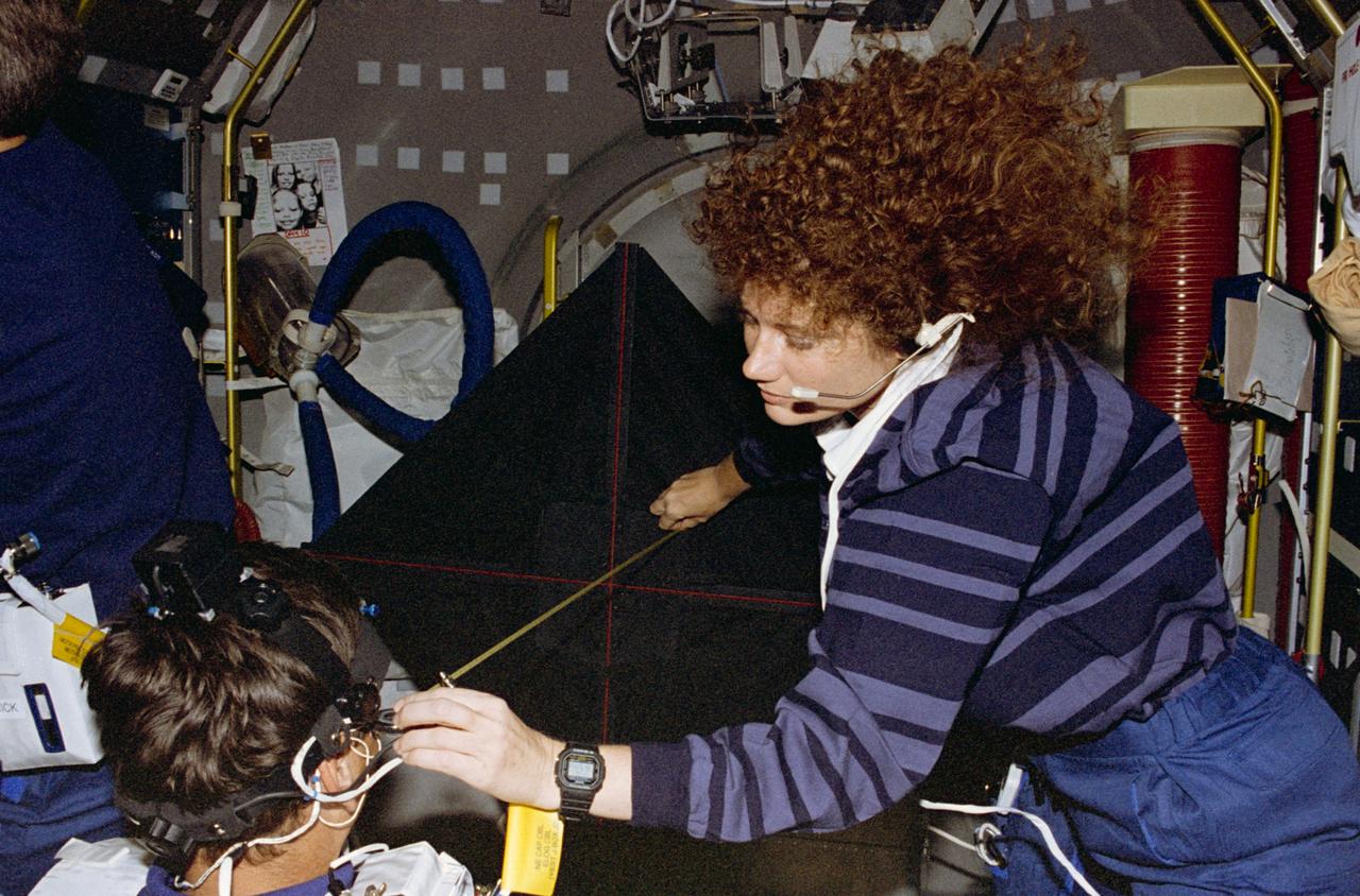
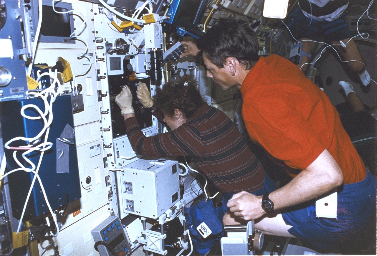
STS078-398-032 (20 June - 7 July 1996) --- Astronaut Susan J. Helms, payload commander, measures the distance between Jean-Jacques Favier’s head and the luminous torque, used for the Canal and Otolith Interaction Study (COIS) on the Life and Microgravity Spacelab (LMS-1) mission. Favier, representing the French Space Agency (CNES), is one of two international payload specialists on the almost-17-day flight. This view shows the Voluntary Head Movement (VHM) segment of the experiment. The VHM is meant to characterize how the coordination of head and eye movement changes as a result of spaceflight. Since most vestibular functions are influenced by gravity, the COIS experiment is meant to measure response differences in microgravity.
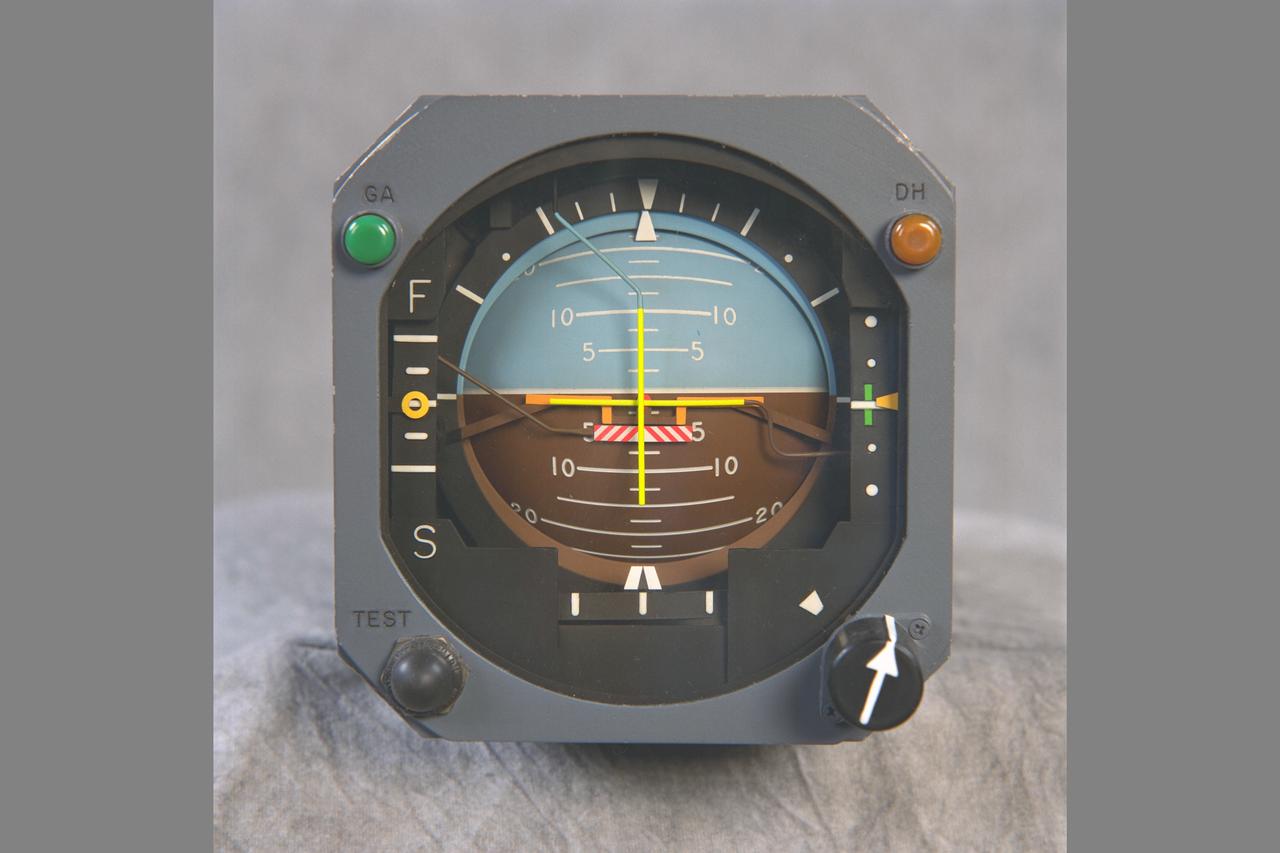
ARTIFICIAL HORIZON gage used in the NASA Ames VMS: S-CAB, (Vertical Motion Simulator).
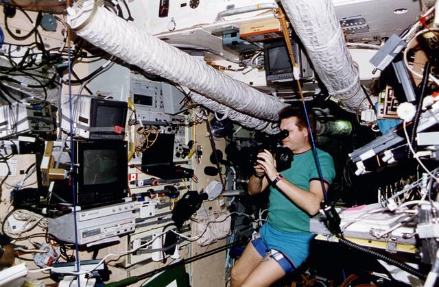
S77-E-5104 (26 May 1996) --- Astronaut Mario Runco, Jr., mission specialist, takes a break from activities on Space Shuttle Endeavour?s middeck. The scene was recorded with an Electronic Still Camera (ESC).
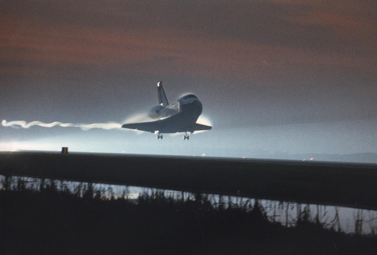
STS077-S-045 (29 May 1996) --- As its main landing gear touches down on Runway 33 at the Kennedy Space Center (KSC), the Space Shuttle Endeavour marks its return to Earth following a ten-day mission in space. Touchdown came at 7:09 a.m. (EDT), May 29, 1996. Leading the crew onboard was astronaut John H. Casper, mission commander. Other crew members were astronauts Curtis L. Brown, Jr., pilot; along with Daniel W. Bursch, Mario Runco, Jr., Andrew S. W. Thomas and Marc Garneau, all mission specialists. Garneau represents the Canadian Space Agency (CSA). During the approximately 10-day mission, the crew performed a variety of payload activities, including microgravity research aboard the Spacehab 4 Module, deployment and retrieval of the Spartan 207 and deployment and rendezvous with the Passive Aerodynamically-Stabilized Magnetically-Damped Satellite (PAMS).
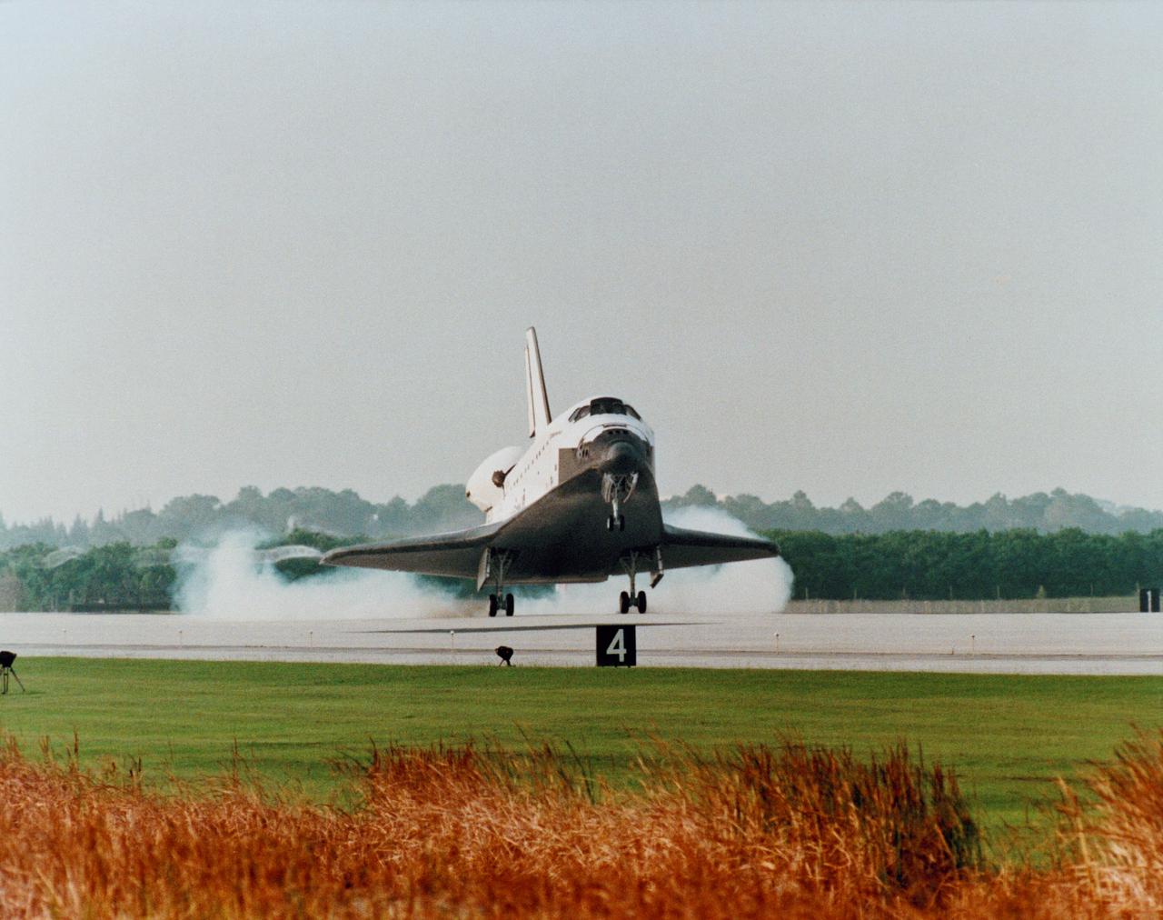
KENNEDY SPACE CENTER, FLA. -- With sunrise just minutes away, the orbiter Columbia swoops down on KSC’s Shuttle Landing Facility, Runway 33. The 33rd KSC landing in Shuttle program history is set to occur on the first opportunity Dec. 7 at 6:49 a.m. EST. Prior landing attempts Dec. 5 and 6 were scrubbed due to weather conditions. The extended time aloft allowed the five- member crew of Mission STS-80 to set a new record for long-duration Shuttle flight. At main gear touchdown, mission duration will be about 17 days, 16 hours, surpassing the 16-day, 21-hour set by the STS-78 crew earlier this year. Guiding Columbia onto the runway is STS-80 Commander Kenneth D. Cockrell; the pilot is Kent V. Rominger. The three mission specialists are Tamara E. Jernigan, Thomas D. Jones and Story Musgrave.
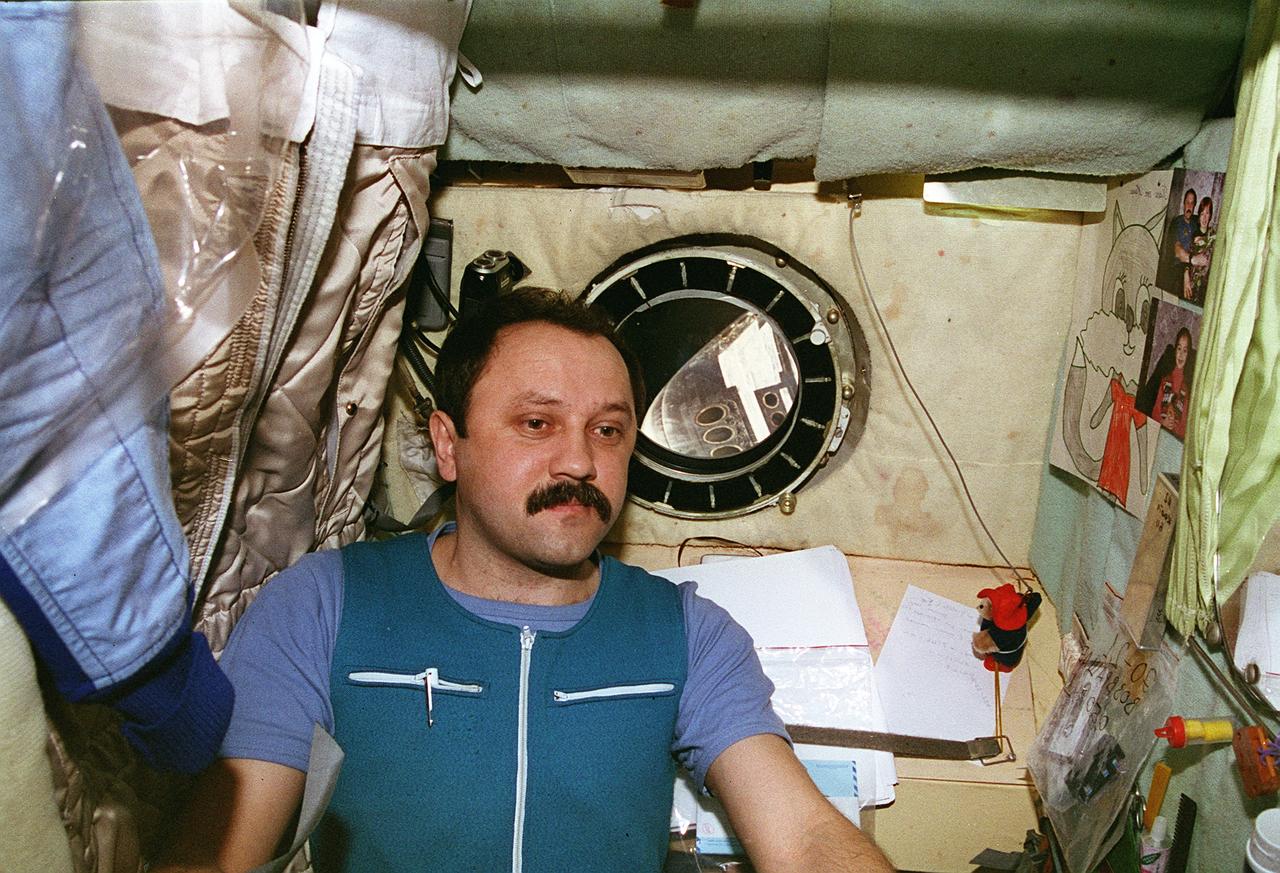
STS076-461-010 (22-31 March 1996) --- The STS-76 crew took this 70mm picture of Russia's Mir-21 mission commander Yury I. Onufrienko using a video camera on the Base Block Module of Russia's Mir Space Station. The STS-76 crew docked the Space Shuttle Atlantis with the Mir Space Station on March 23, 1996, at which time astronaut Shannon W. Lucid (out of frame) joined Onufrienko and the mission's flight engineer, Yury V. Usachev, to begin the first leg of a 140-day stay aboard Mir, as a cosmonaut guest researcher.
Slovakian Incubator (N-240, rm 133c)
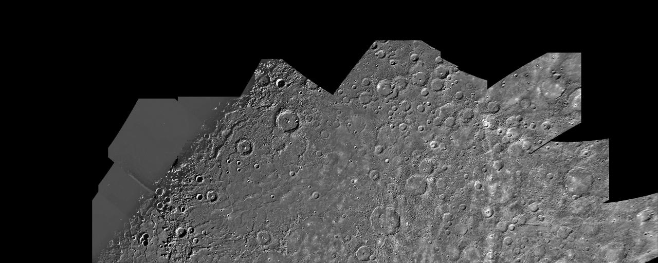
This image, from NASA Mariner 10 spacecraft which launched in 1974, is of the northern half of Mercury Shakespeare Quadrangle. http://photojournal.jpl.nasa.gov/catalog/PIA00066
STS076-356-016 (22 - 31 March 1996) --- With camera in hand, astronaut Richard A. Searfoss, pilot, traverses the maze of modules on Russia's Mir Space Station. The photograph was taken with a 35mm camera by one of Searfoss' crew mates. The astronauts were aboard the Mir Space Station for a brief visit following the delivery of astronaut Shannon W. Lucid, cosmonaut guest researcher.
STS-79 mission commander William F. Readdy checks the center-line docking camera in the orbiter docking system (ODS) during flight day 3. The camera will be used on flight day 4 to line up the Atlantis for its docking with the Mir space station.
STS077-S-044 (16 April 1996) --- The Space Shuttle Endeavour atop the Mobile Launcher Platform and Crawler-Transporter (MLP/CT) slowly lumbers past a tree alongside the crawlerway, at the Kennedy Space Center (KSC). The journey from the Vehicle Assembly Building (VAB) to Launch Pad 39B will take about five to six hours to complete. Once hard down at the pad, preparations will continue to ready Endeavour for its upcoming spaceflight on STS-77.
This Magellan image is centered at 74.6 degrees north latitude and 177.3 east longitude, in the northeastern Atalanta Region of Venus. The image is approximately 185 kilometers (115 miles) wide at the base and shows Dickinson, an impact crater 69 kilometers (43 miles) in diameter. The crater is complex, characterized by a partial central ring and a floor flooded by radar-dark and radar-bright materials. Hummocky, rough-textured ejecta extend all around the crater, except to the west. The lack of ejecta to the west may indicate that the impactor that produced the crater was an oblique impact from the west. Extensive radar-bright flows that emanate from the crater's eastern walls may represent large volumes of impact melt, or they may be the result of volcanic material released from the subsurface during the cratering event. http://photojournal.jpl.nasa.gov/catalog/PIA00479

Taken by the Wide Field Planetary Camera 2 (WFPC2) of the Hubble Space Telescope (HST), this image of MyCn18, a young planetary nebula located about 8,000 light-years away, reveals its true shape to be an hourglass with an intricate pattern of "etchings" in its walls. The arc-like etchings could be the remnants of discrete shells ejected from the star when it was younger, flow instabilities, or could result from the action of a narrow beam of matter impinging on the hourglass walls. According to one theory on the formation of planetary nebulae, the hourglass shape is produced by the expansion of a fast stellar wind within a slowly expanding cloud, which is denser near its equator than near its poles. Hubble has also revealed other features in MyCn18 which are completely new and unexpected. For example, there is a pair of intersecting elliptical rings in the central region which appear to be the rims of a smaller hourglass. This picture has been composed from three separate images taken in the light of ionized nitrogen (represented by red), hydrogen (green) and doubly-ionized oxygen (blue). The results are of great interest because they shed new light on the poorly understood ejection of stellar matter which accompanies the slow death of sun-like stars. An unseen companion star and accompanying gravitational effects may well be necessary in order to explain the structure of MyCn18. The Marshall Space Flight Center (MSFC) had responsibility for design, development, and construction of the HST.
STS075-302-016 (22 Feb.-9 March 1996) --- Soon after reaching Earth orbit, the blue shift team set up what they referred to as a "formal" meal on the space shuttle Columbia's middeck. Left to right are astronauts Franklin R. Chang-Diaz, STS-75 payload commander; Jeffrey A. Hoffman and Claude Nicollier, both mission specialists. Hoffman later told a gathering of Johnson Space Center employees that the meal was accompanied by classical music. Photo credit: NASA or National Aeronautics and Space Administration
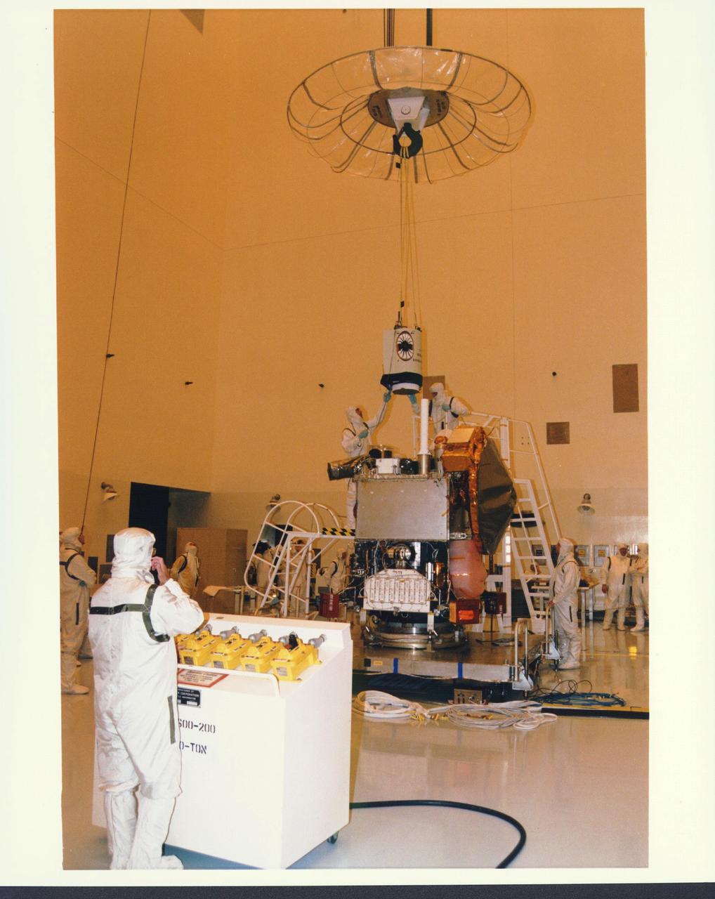
KENNEDY SPACE CENTER, FLA. - In the Payload Hazardous Servicing Facility at KSC, installation is under way of the Mars Orbiter Camera (MOC) on the Mars Global Surveyor spacecraft. The MOC is one of a suite of six scientific instruments that will gather data about Martian topography, mineral distribution and weather during a two-year period. The Mars Global Surveyor is slated for launch aboard a Delta II expendable launch vehicle on Nov. 6, the beginning of a 20-day launch period.

This false-color mosaic was constructed from a series of 53 images taken through three spectral filters by NASA's Galileo imaging system as the spacecraft flew over the northern regions of the Moon on December 7, 1992. http://photojournal.jpl.nasa.gov/catalog/PIA00131
Ushas Mons, a volcano in the southern hemisphere of Venus is shown in this radar image from NASA Magellan spacecraft. The volcano is marked by numerous bright lava flows and a set of north-south trending fractures. http://photojournal.jpl.nasa.gov/catalog/PIA00272
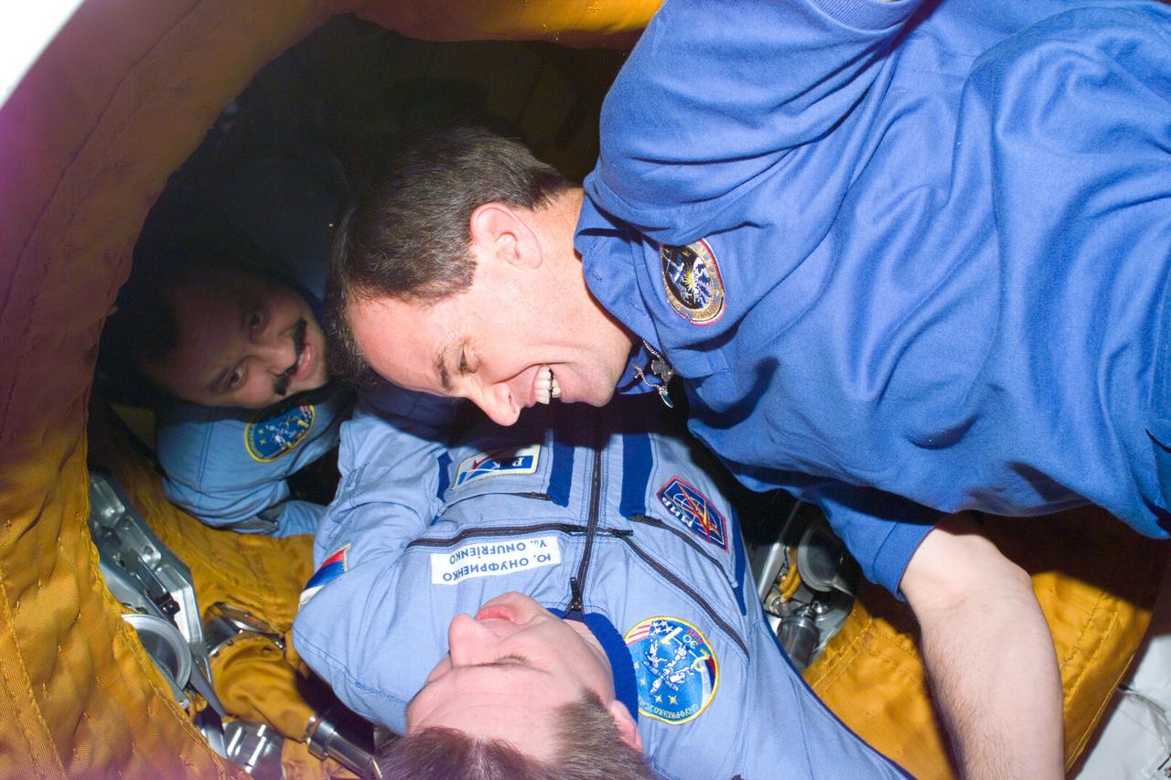
S76-E-5146 (24 March 1996) --- Continuing an in-space tradition, astronaut Kevin P. Chilton (right), STS-76 mission commander, shakes hands with cosmonaut Yury Onufrienko, Mir-21 commander, in the tunnel connecting the Space Shuttle Atlantis and Russia's Mir Space Station. A short time earlier two crews successfully pulled off the third hard-docking of their respective spacecraft. In the background is cosmonaut Yury V. Usachev, Mir-21 flight engineer. The image was recorded with a 35mm Electronic Still Camera (ESC) and downlinked at a later time to ground controllers in Houston, Texas.
Robot Brain Operation and Test Bed. N-269 with Robert Mah and Dr. Russell Andrews. Palo Alto VA Stanford.
This image from NASA Magellan spacecraft is of an area located in the Eistla Region of Venus in the southern hemisphere. http://photojournal.jpl.nasa.gov/catalog/PIA00089
STS075-355-032 (9 March 1996) --- Payload specialist Umberto Guidoni, wearing the shuttle launch and entry garment, prepares for the de-orbit phase of the 16-day flight. Guidoni represents the Italian Space Agency (ASI). The seven member crew was launched aboard the Space Shuttle Columbia on February 22, 1996, and landed on March 9, 1996. Crew members were Andrew M. Allen, mission commander; Scott J. Horowitz, pilot; Franklin R. Chang-Diaz, payload commander; and Maurizio Cheli, European Space Agency (ESA); Jeffrey A. Hoffman and Claude Nicollier, (ESA), all mission specialists; along with Guidoni.
Researchers at Marshall's Space Science Laboratory successfully demonstrate that linear arrays of Hall probes can be constructed in high Hall coefficient films and used to digitally image magnetic fields. This research is beneficial to visually imaging any magnetic field.
STS076-E-05264 (22-31 March 1996) --- STS-76 KidSat Earth View (Morocco)
KENNEDY SPACE CENTER, FLA. -- A diversified mission of astronomy, commercial space research and International Space Station preparation gets under way as the Space Shuttle Columbia climbs skyward from Launch Pad 39B at 2:55:47 p.m. EST, Nov. 19, 1996. Leading the veteran crew of Mission STS-80 is Commander Kenneth D. Cockrell; Kent V. Rominger is the pilot and the three mission specialists are Tamara E. Jernigan, Story Musgrave and Thomas D. Jones. At age 61, Musgrave becomes the oldest person ever to fly in space; he also ties astronaut John Young’s record for most number of spaceflights by a human being, and in embarking on his sixth Shuttle flight Musgrave has logged the most flights ever aboard NASA’s reusable space vehicle. The two primary payloads for STS-80 are the Wake Shield Facility-3 (WSF-3) and the Orbiting and Retrievable Far and Extreme Ultraviolet Spectrometer-Shuttle Pallet Satellite II (ORFEUS-SPAS II). Two spacewalks also will be performed during the nearly 16-day mission. Mission STS-80 closes out the Shuttle flight schedule for 1996; it marks the 21st flight for Columbia and the 80th in Shuttle program history.
NASA's Magellan radar image shows Alpha Regio, a topographic upland. In 1963 Alpha Regio was the first feature on Venus to be identified from Earth based radar. http://photojournal.jpl.nasa.gov/catalog/PIA00147

Launched on June 20, 1996, the STS-78 mission’s primary payload was the Life and Microgravity Spacelab (LMS), which was managed by the Marshall Space Flight Center (MSFC). During the 17 day space flight, the crew conducted a diverse slate of experiments divided into a mix of life science and microgravity investigations. In a manner very similar to future International Space Station operations, LMS researchers from the United States and their European counterparts shared resources such as crew time and equipment. Five space agencies (NASA/USA, European Space Agency/Europe (ESA), French Space Agency/France, Canadian Space Agency /Canada, and Italian Space Agency/Italy) along with research scientists from 10 countries worked together on the design, development and construction of the LMS. This photo represents payload specialist, Robert Thirsk, involved in an onboard experiment.
This mosaic of Magellan data in the Fortuna region of Venus, centered at 49 degrees north latitude, 2 degrees longitude, shows two coronae. Coronae are large circular or oval structures first identified in Soviet radar images of Venus. The structure on the left, Bahet Corona, is about 230 kilometers (138 miles) long and 150 kilometers (90 miles) across. A portion of Onatah Corona, over 350 kilometers (210 miles) in diameter, can be seen on the right of the mosaic. Both features are surrounded by a ring of ridges and troughs, which in places cut more radially-oriented fractures. The centers of the features also contain radial fractures as well as volcanic domes and flows. Coronae are thought to form due to the upwelling of hot material from deep in the interior of Venus. The two coronae may have formed at the same time over a single upwelling, or may indicate movement of the upwelling or the upper layers of the planet to the west over time. A 'pancake' dome, similar to low-relief domes see in the southern hemisphere, is located just to the southwest of Bahet. Resolution of the Magellan data is about 120 meters (400 feet). http://photojournal.jpl.nasa.gov/catalog/PIA00461
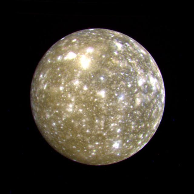
This false color picture of Callisto was taken by NASA's Voyager 2 on July 7, 1979 at a range of 1,094,666 kilometers (677,000 miles) and is centered on 11 degrees N and 171 degrees W. This rendition uses an ultraviolet image for the blue component. Because the surface displays regional contrast in UV, variations in surface materials are apparent. Notice in particular the dark blue haloes which surround bright craters in the eastern hemisphere. The surface of Callisto is the most heavily cratered of the Galilean satellites and resembles ancient heavily cratered terrains on the moon, Mercury and Mars. The bright areas are ejecta thrown out by relatively young impact craters. A large ringed structure, probably an impact basin, is shown in the upper left part of the picture. The color version of this picture was constructed by compositing black and white images taken through the ultraviolet, clear and orange filters. http://photojournal.jpl.nasa.gov/catalog/PIA00457
Antarctic: Dry Valleys expedition 1996 (Chris McKay party)
U.S. Space Camp California 'Day Camp' Grand Opening with Kenin Jones (Whisman School) Lucretia Sutherlin (McNair School) and Rachael Quiring