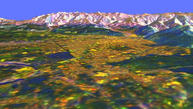
This is a three-dimensional perspective view of Missoula, Montana, created by combining two spaceborne radar images using a technique known as interferometry.
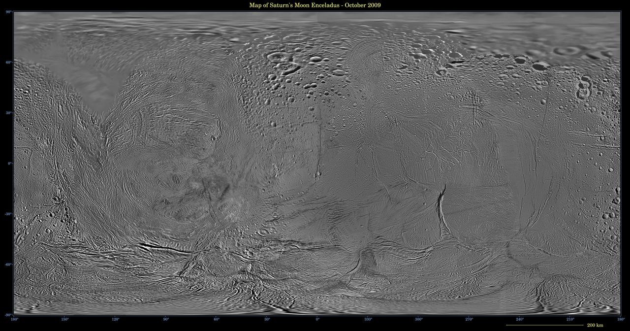
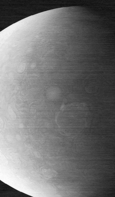
This image shows an updated map of Saturn icy moon Enceladus, generated by NASA Cassini imaging team. The map incorporates new images taken in 2008, with better image processing techniques.
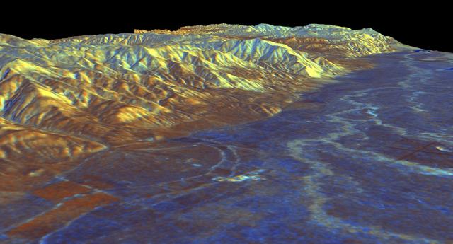
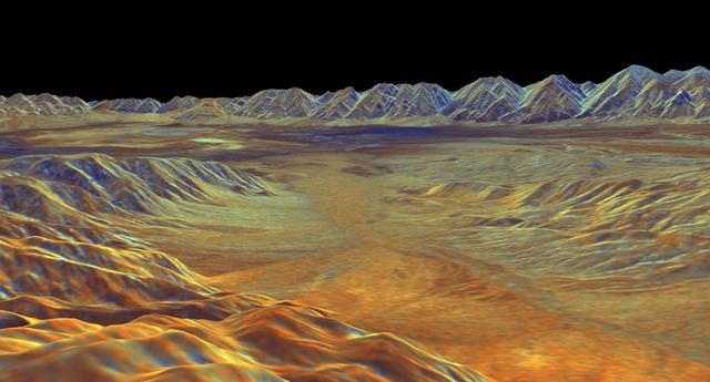
This is a three-dimensional perspective view of Owens Valley, near the town of Bishop, California that was created by combining two spaceborne radar images using a technique known as interferometry.
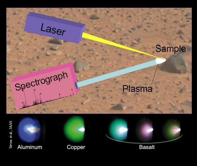
This image illustrates the principals of a technique called laser-induced breakdown spectroscopy, which the Chemistry and Camera ChemCam instrument onboard NASA rover, Curiosity, will use on Mars.
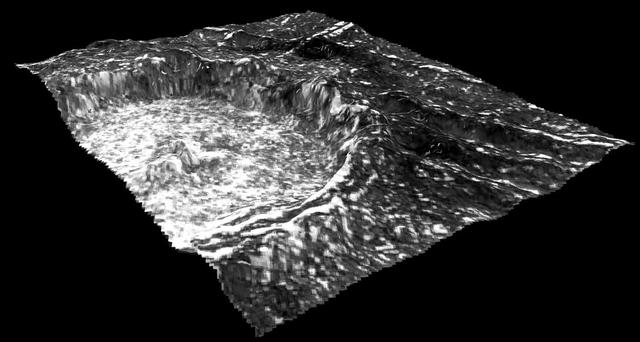
This view of Cilix impact crater on Europa was created in 2013 using 3-D stereo images taken by NASA Galileo spacecraft, combined with advanced image processing techniques.
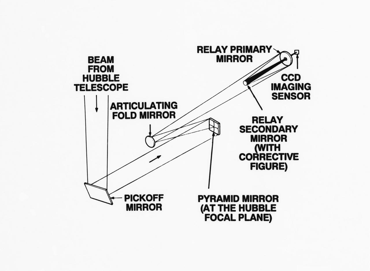
S93-33258 (15 Mar 1993) --- An optical schematic diagram of one of the four channels of the Wide Field\Planetary Camera-2 (WF\PC-2) shows the path taken by beams from the Hubble Space Telescope (HST) before an image is formed at the camera's charge-coupled devices. A team of NASA astronauts will pay a visit to the HST later this year, carrying with them the new WF/PC-2 to replace the one currently on the HST. The Jet Propulsion Laboratory in Pasadena, California has been working on the replacement system for several months. See NASA photo S93-33257 for a close-up view of tiny articulating mirrors designed to realign incoming light in order to make certain the beams fall precisely in the middle of the secondary mirrors.
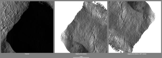
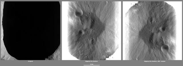
These images from NASA Dawn spacecraft, located in asteroid Vesta Marcia quadrangle, in Vesta northern hemisphere, demonstrate a special analytical technique, which results in shadowed areas of Vesta surface becoming illuminated.
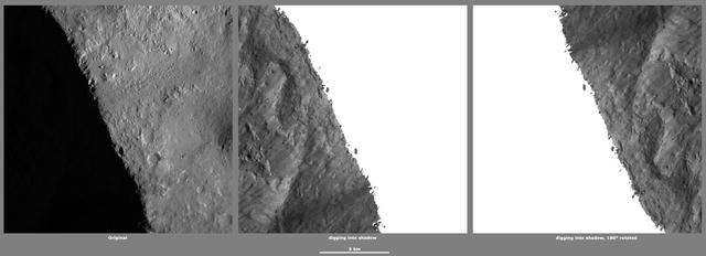
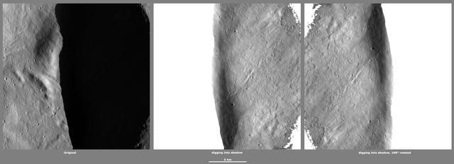
These images from NASA Dawn spacecraft, located in asteroid Vesta Marcia quadrangle, in Vesta northern hemisphere, demonstrate a special analytical technique, which results in shadowed areas of Vesta surface becoming illuminated.
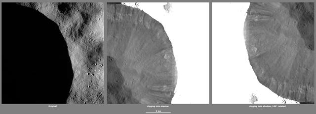
These images from NASA Dawn spacecraft, located in asteroid Vesta Oppia quadrangle, in Vesta northern hemisphere, demonstrate a special analytical technique, which results in shadowed areas of Vesta surface becoming illuminated.
This image is one of two frames showing NASA Spirit driving backward as next technique for attempting to extricate the rover from the sand trap where it is embedded. Go to the Photojournal for the animation.

Image of Surveyor 1 shadow against the lunar surface in the late lunar afternoon, with the horizon at the upper right. Surveyor 1, the first of the Surveyor missions to make a successful soft landing, proved the spacecraft design and landing technique
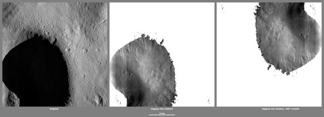
These images from NASA Dawn spacecraft, located in asteroid VestaFloronia quadrangle, in Vesta northern hemisphere, demonstrate a special analytical technique, which results in shadowed areas of Vesta surface becoming illuminated.
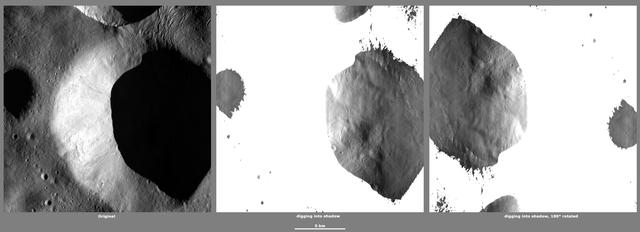
These images from NASA Dawn spacecraft, located in Vesta Caparronia quadrangle, in Vesta northern hemisphere, demonstrate a special analytical technique, which results in shadowed areas of Vesta surface becoming illuminated.
This is a three-dimensional perspective view of Saline Valley, about 30 km 19 miles east of the town of Independence, California created by combining two spaceborne radar images using a technique known as interferometry.
These images from NASA Dawn spacecraft, located in asteroid Vesta Caparronia quadrangle, in Vesta northern hemisphere, demonstrate a special analytical technique, which results in shadowed areas of Vesta surface becoming illuminated.
These images from NASA Dawn spacecraft, located in asteroid Vesta Floronia quadrangle, in Vesta northern hemisphere, demonstrate a special analytical technique, which results in shadowed areas of Vesta surface becoming illuminated.
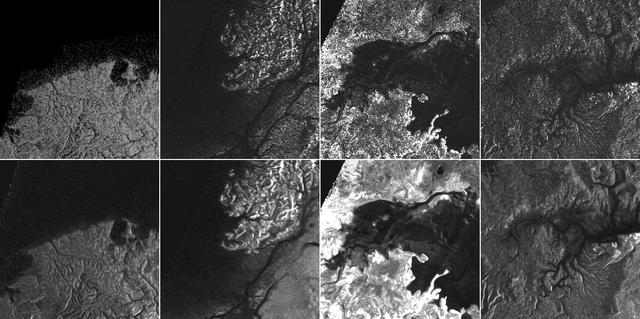
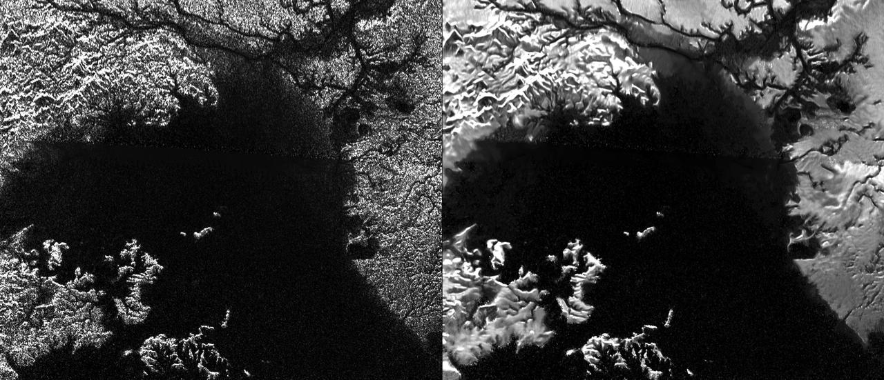
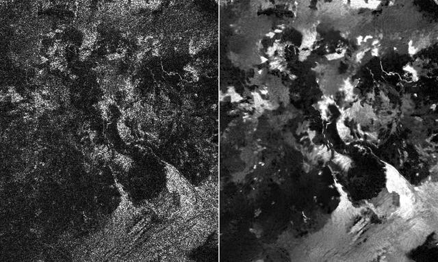
This montage of Cassini Synthetic Aperture Radar (SAR) images of the surface of Titan shows four examples of how a newly developed technique for handling noise results in clearer, easier to interpret views. The top row of images was produced in the manner used since the mission arrived in the Saturn system a decade ago; the row at bottom was produced using the new technique. The three leftmost image pairs show bays and spits of land in Ligea Mare, one of Titan's large hydrocarbon seas. The rightmost pair shows a valley network along Jingpo Lacus, one of Titan's larger northern lakes. North is toward the left in these images. Each thumbnail represents an area 70 miles (112 kilometers) wide. http://photojournal.jpl.nasa.gov/catalog/PIA19053
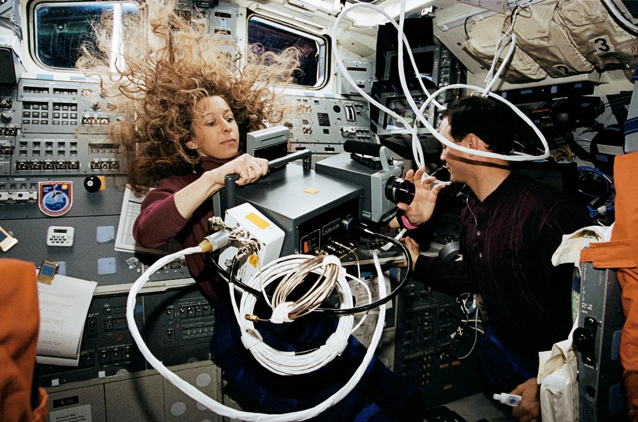
STS062-04-005 (4-18 March 1994) --- Astronaut Marsha S. Ivins has her hands full with a thermal imaging project on the flight deck of the Space Shuttle Columbia as astronaut Pierre J. Thuot stands by to help. The two mission specialists were joined by three other veteran NASA astronauts for almost 14 full days in Earth-orbit.
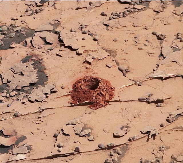
A close-up image of a 2-inch-deep hole produced using a new drilling technique for NASA's Curiosity rover. The hole is about 0.6 inches (1.6 centimeters) in diameter. This image was taken by Curiosity's Mast Camera (Mastcam) on Sol 2057. It has been white balanced and contrast-enhanced. Curiosity drilled this hole in a target called "Duluth" on May 20, 2018. It was the first rock sample captured by the drill since October 2016. A mechanical issue took the drill offline in December 2016. https://photojournal.jpl.nasa.gov/catalog/PIA22326
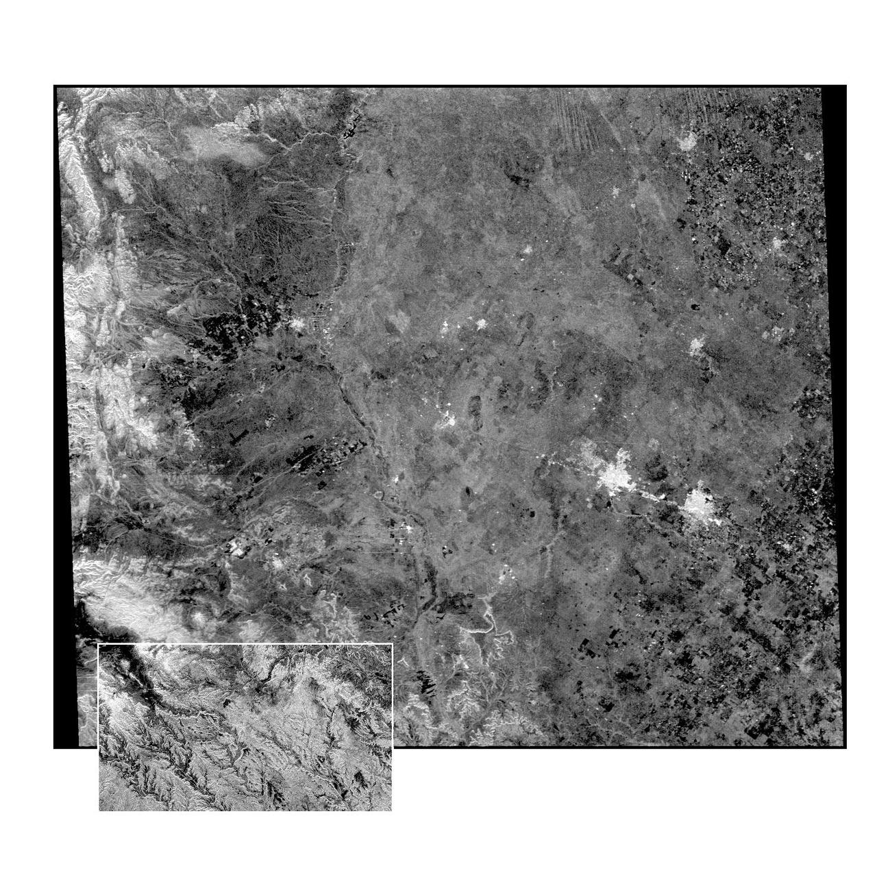
This radar image of the Midland/Odessa region of West Texas, demonstrates an experimental technique, called ScanSAR, that allows scientists to rapidly image large areas of the Earth's surface. The large image covers an area 245 kilometers by 225 kilometers (152 miles by 139 miles). It was obtained by the Spaceborne Imaging Radar-C/X-Band Synthetic Aperture Radar (SIR-C/X-SAR) flying aboard the space shuttle Endeavour on October 5, 1994. The smaller inset image is a standard SIR-C image showing a portion of the same area, 100 kilometers by 57 kilometers (62 miles by 35 miles) and was taken during the first flight of SIR-C on April 14, 1994. The bright spots on the right side of the image are the cities of Odessa (left) and Midland (right), Texas. The Pecos River runs from the top center to the bottom center of the image. Along the left side of the image are, from top to bottom, parts of the Guadalupe, Davis and Santiago Mountains. North is toward the upper right. Unlike conventional radar imaging, in which a radar continuously illuminates a single ground swath as the space shuttle passes over the terrain, a Scansar radar illuminates several adjacent ground swaths almost simultaneously, by "scanning" the radar beam across a large area in a rapid sequence. The adjacent swaths, typically about 50 km (31 miles) wide, are then merged during ground processing to produce a single large scene. Illumination for this L-band scene is from the top of the image. The beams were scanned from the top of the scene to the bottom, as the shuttle flew from left to right. This scene was acquired in about 30 seconds. A normal SIR-C image is acquired in about 13 seconds. The ScanSAR mode will likely be used on future radar sensors to construct regional and possibly global radar images and topographic maps. The ScanSAR processor is being designed for 1996 implementation at NASA's Alaska SAR Facility, located at the University of Alaska Fairbanks, and will produce digital images from the forthcoming Canadian RADARSAT satellite. http://photojournal.jpl.nasa.gov/catalog/PIA01787
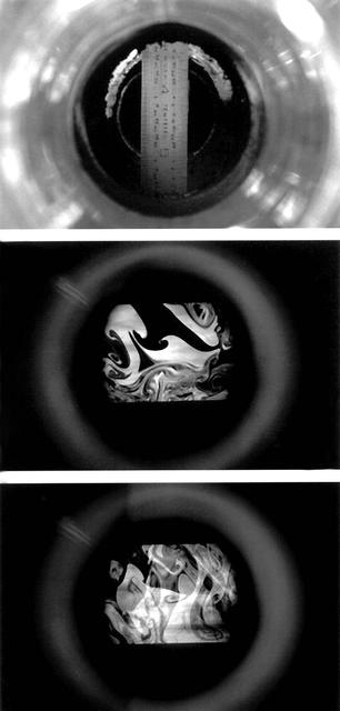
LII is a technique for measuring soot concentration. This image was taken with an ordinary 35-mm camera, these reveal soot distribution within the chimney. Principal Investigator: Dr. Randall L. Vander Wal
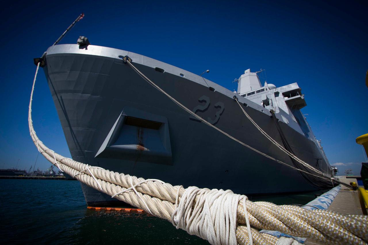
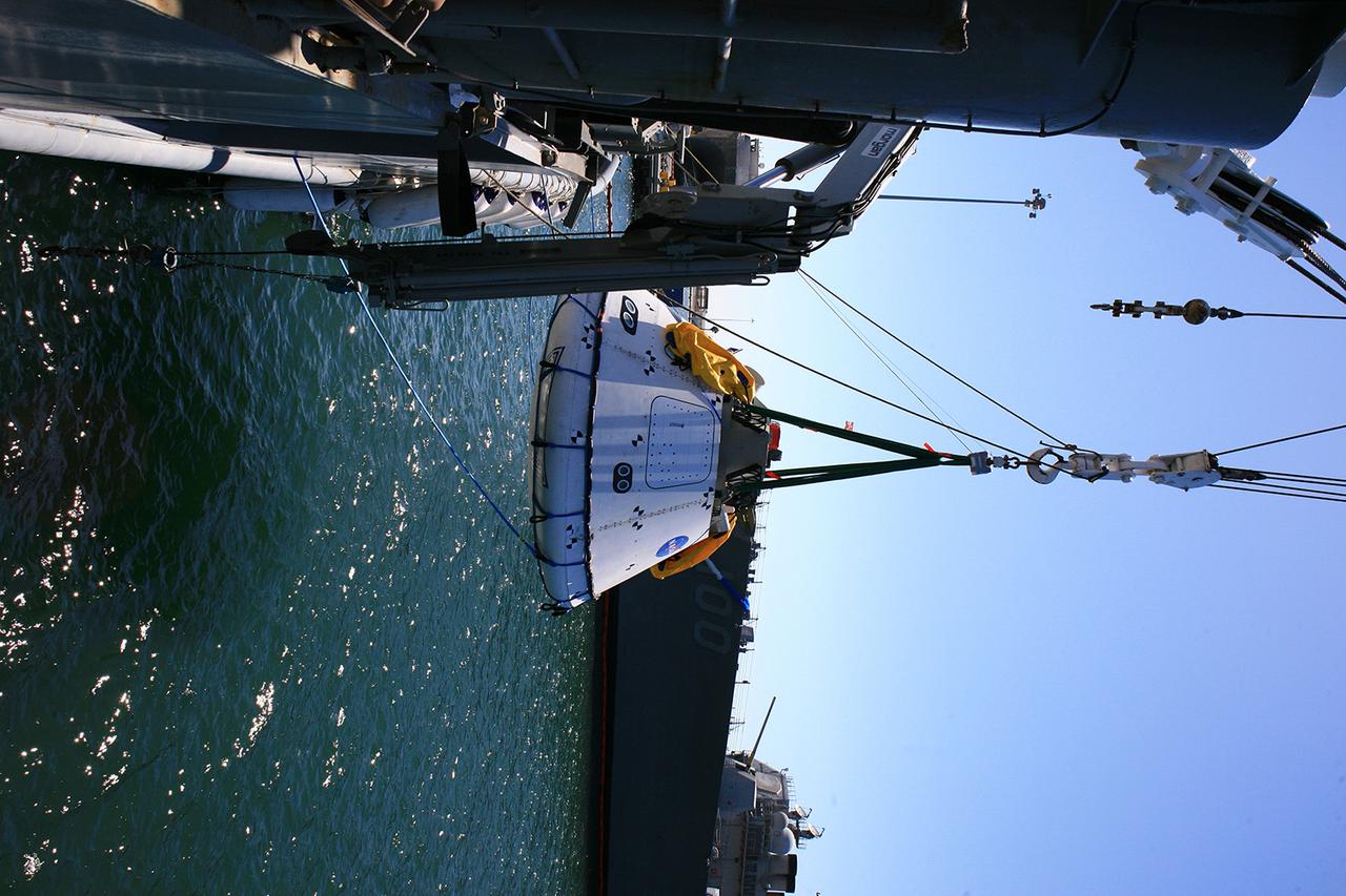
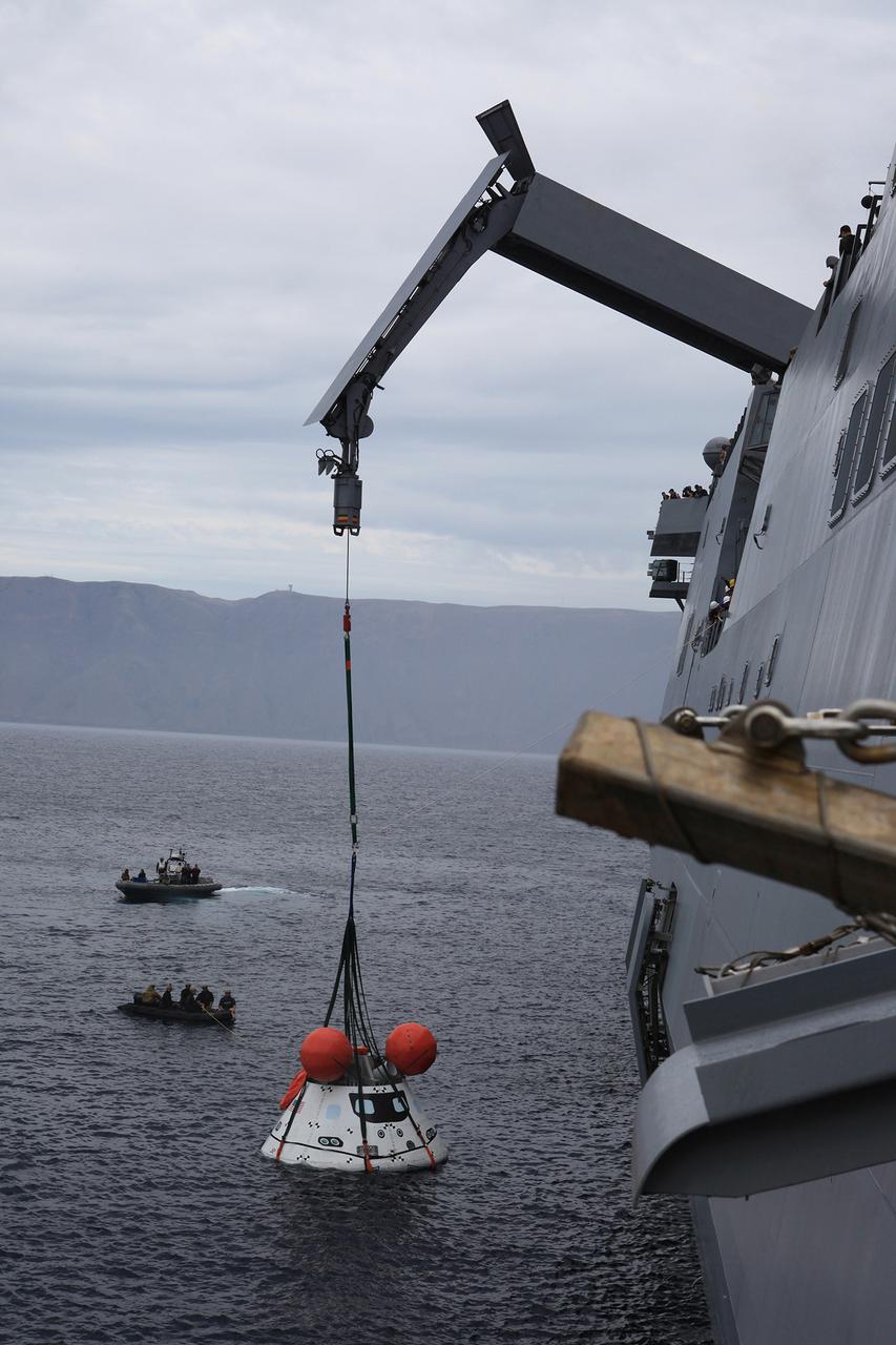
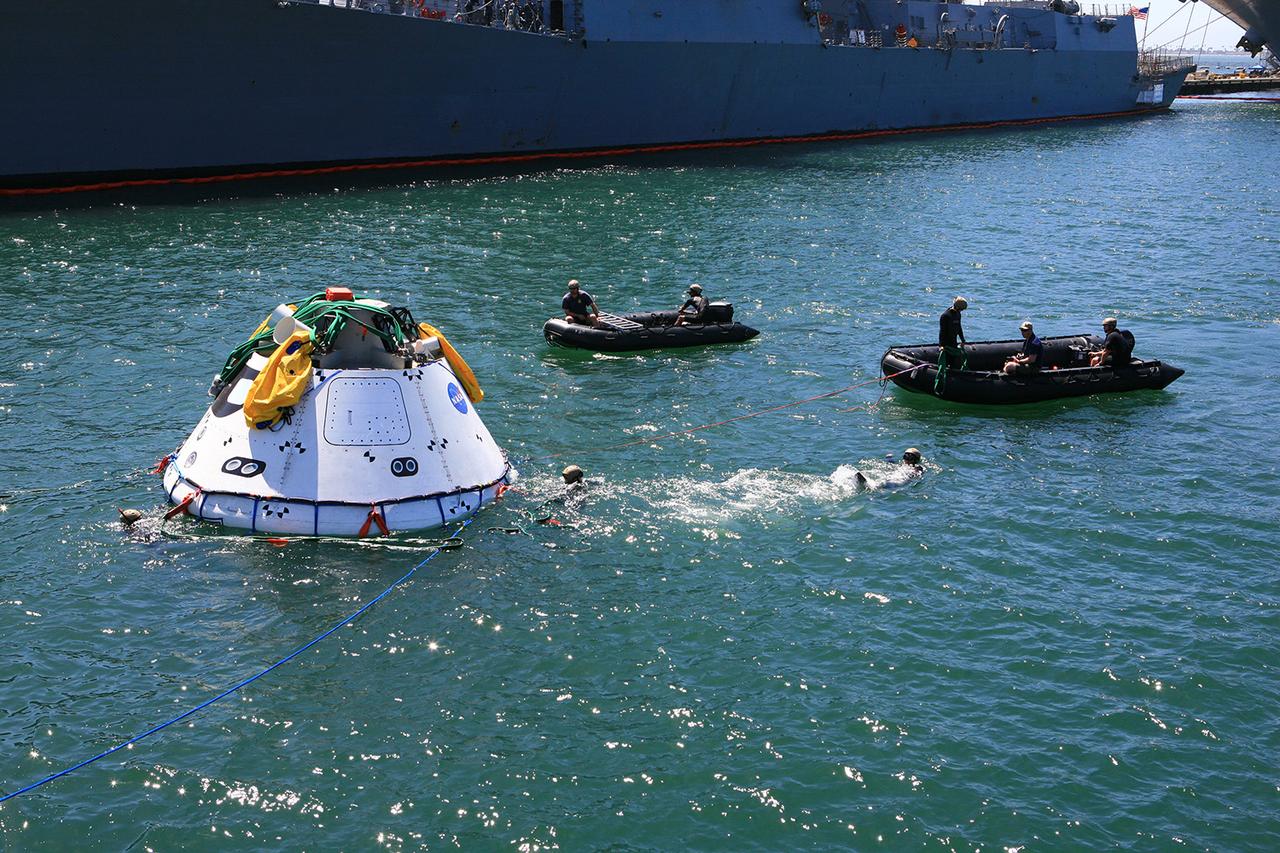
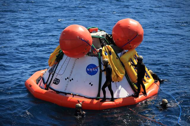
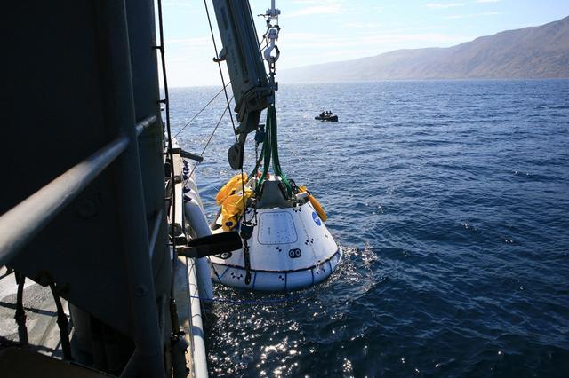
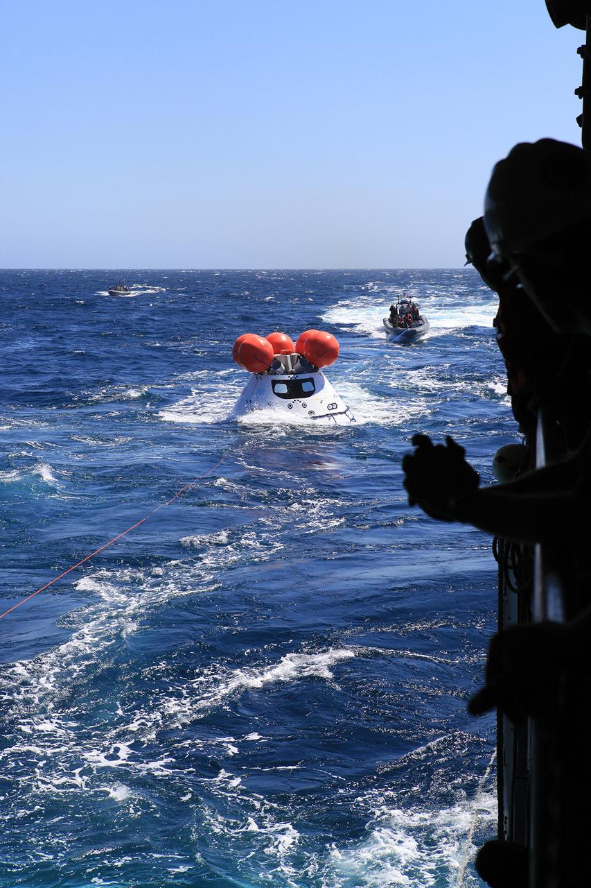
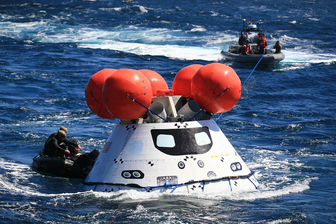
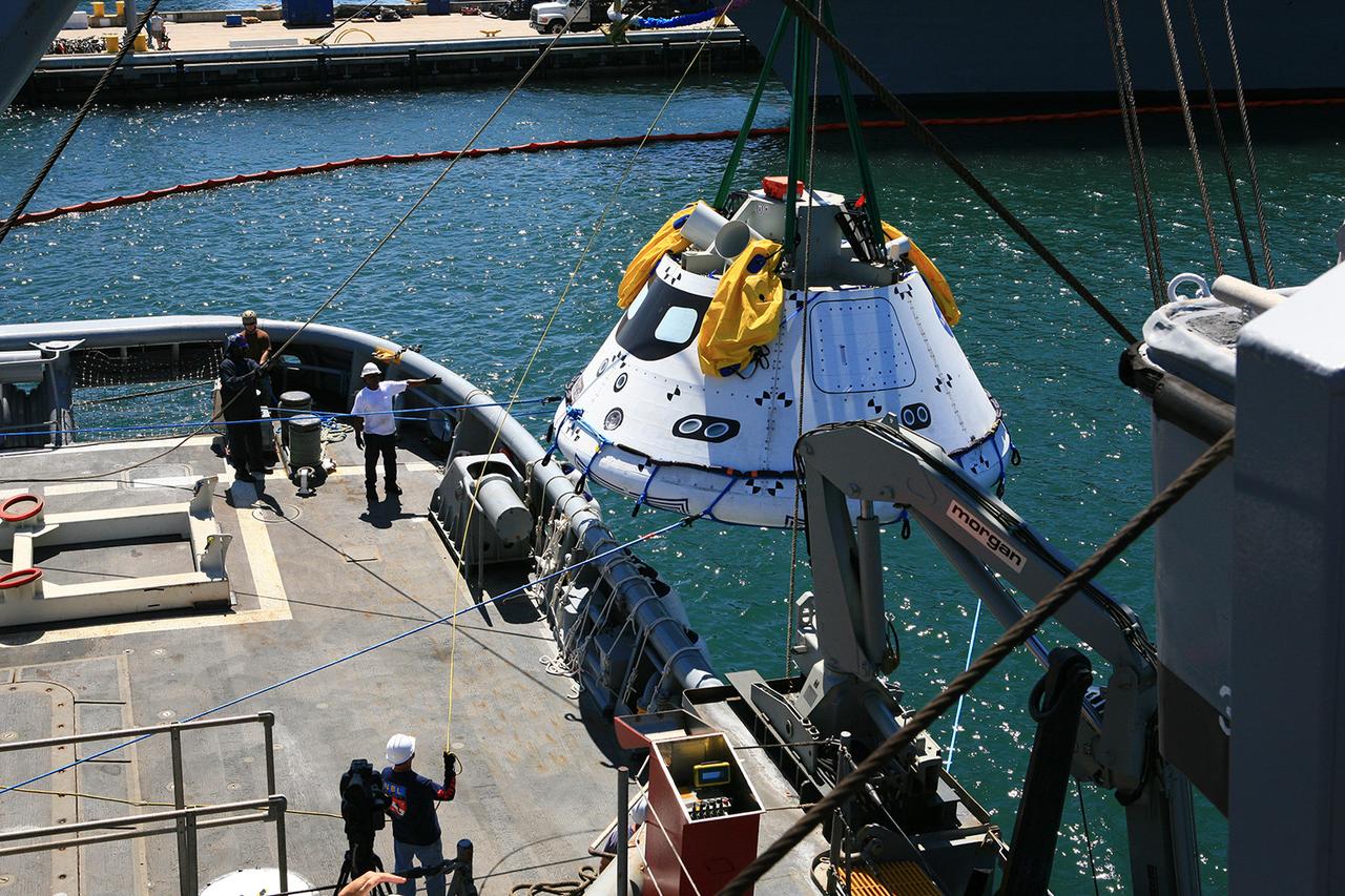
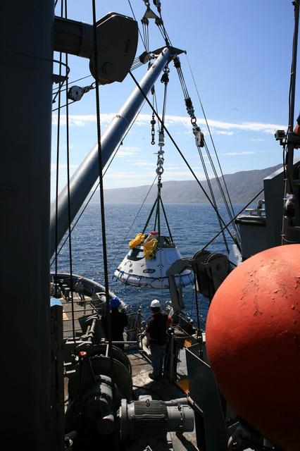
The Navy's USS Anchorage is used to test Orion recovery tools and techniques in the Pacific Ocean off the coast of San Diego on Sept. 12, 2014. Part of Batch image transfer from Flickr.
NASA and Navy personnel on board the Salvor used the ship's crane to test recovery techniques on Sept. 15, 2014, prior to Exploration Flight Test-1 (EFT-1). Part of Batch image transfer from Flickr.
Presented here are side-by-side comparisons of a traditional Cassini Synthetic Aperture Radar (SAR) view and one made using a new technique for handling electronic noise that results in clearer views of Titan's surface. The technique, called despeckling, produces images that can be easier for researchers to interpret. The view is a mosaic of SAR swaths over Ligeia Mare, one of the large hydrocarbons seas on Titan. In particular, despeckling improves the visibility of channels flowing down to the sea. http://photojournal.jpl.nasa.gov/catalog/PIA19052
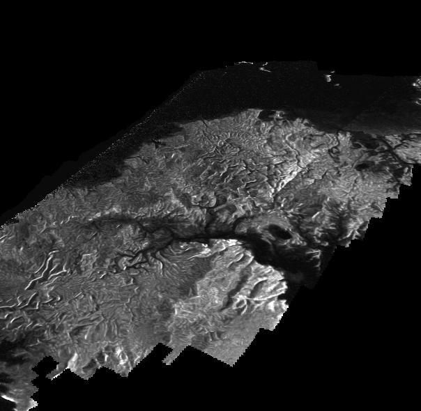
This Cassini Synthetic Aperture Radar (SAR) image is presented as a perspective view and shows a landscape near the eastern shoreline of Kraken Mare, a hydrocarbon sea in Titan's north polar region. This image was processed using a technique for handling noise that results in clearer views that can be easier for researchers to interpret. The technique, called despeckling, also is useful for producing altimetry data and 3-D views called digital elevation maps. Scientists have used a technique called radargrammetry to determine the altitude of surface features in this view at a resolution of approximately half a mile, or 1 kilometer. The altimetry reveals that the area is smooth overall, with a maximum amplitude of 0.75 mile (1.2 kilometers) in height. The topography also shows that all observed channels flow downhill. The presence of what scientists call "knickpoints" -- locations on a river where a sharp change in slope occurs -- might indicate stratification in the bedrock, erosion mechanisms at work or a particular way the surface responds to runoff events, such as floods following large storms. One such knickpoint is visible just above the lower left corner, where an area of bright slopes is seen. The image was obtained during a flyby of Titan on April 10, 2007. A more traditional radar image of this area on Titan is seen in PIA19046. http://photojournal.jpl.nasa.gov/catalog/PIA19051
This image capturing one of the circumpolar cyclones on Jupiter's north pole was taken Nov. 22, 2023, by the JunoCam imager aboard NASA's Juno as the spacecraft flew past at an altitude of about 10,880 miles (17,500 kilometers). The horizontal lines and overall graininess of the image show the effects of radiation damage on the camera. The Juno team has been experimenting with a technique called annealing to address the damage and restore the quality of JunoCam images. https://photojournal.jpl.nasa.gov/catalog/PIA26642
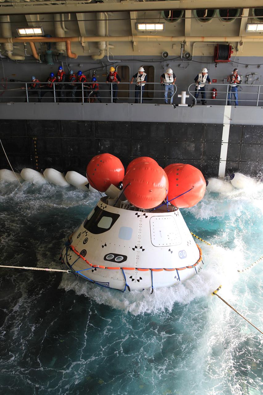
The Orion boilerplate test article inside the well deck of the USS Anchorage during recovery practice operations Aug. 4, 2014. NASA and U.S. Navy practiced recovery techniques off the coast of California, in preparation for Exploration Flight Test-1 (EFT-1). Part of Batch image transfer from Flickr.
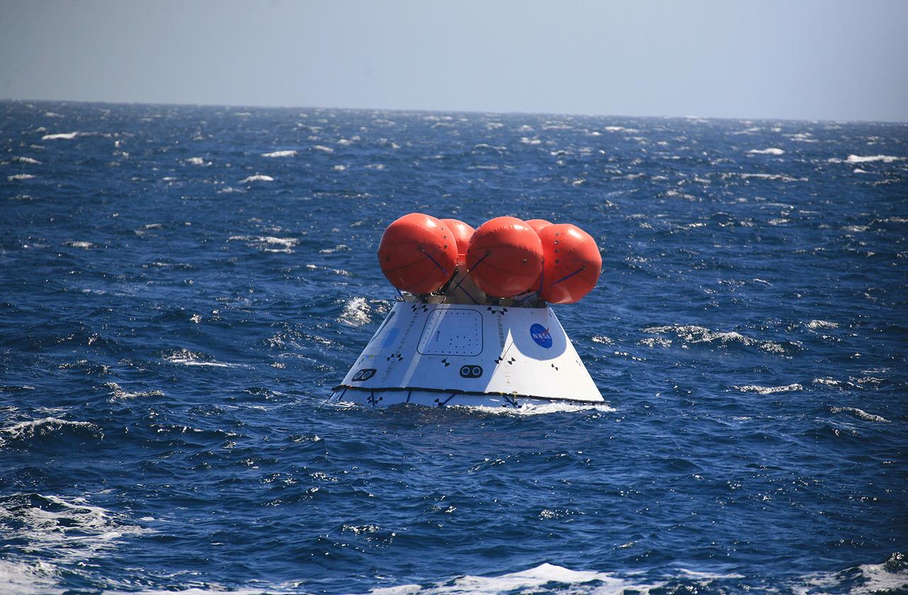
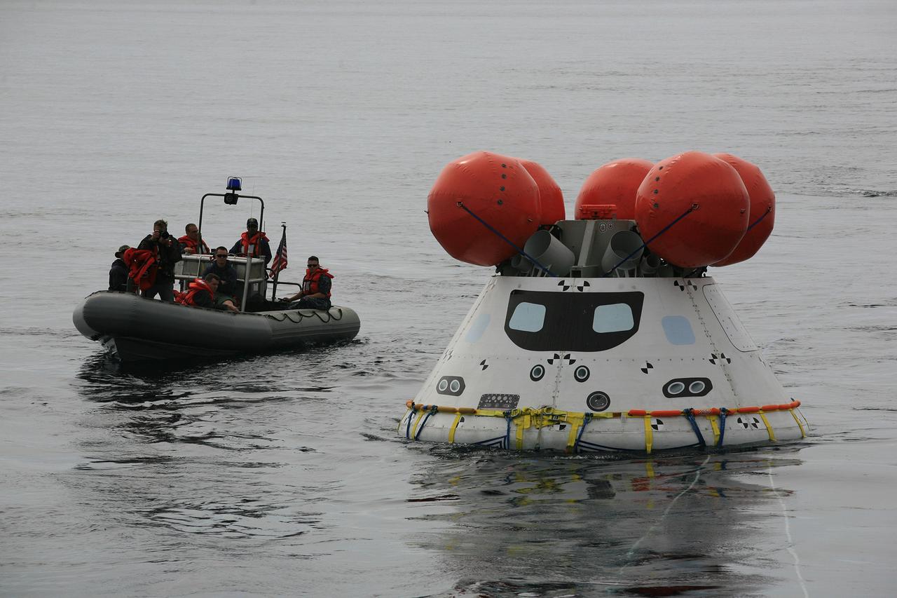
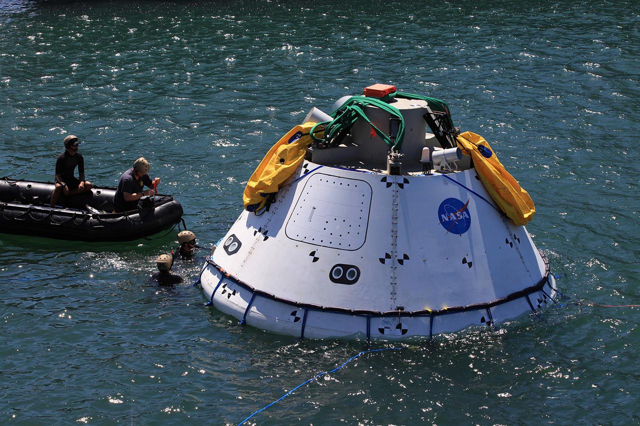
A test version of Orion floats in the Pacific Ocean, ready to be recovered by NASA and the US Navy on Sept. 17, 2014. The combined NASA/Navy team is testing tools and techniques that will be used to retrieve Orion when it splashes down following Exploration Flight Test-1 (EFT-1). Part of Batch image transfer from Flickr.
Recovery team members work with a test version of Orion floating in the well deck of the U.S.S. Anchorage on Aug. 2, 2014. A combined NASA and U.S. Navy team practiced recovery techniques off the coast of California in preparation for Exploration Flight Test-1 (EFT-1). Part of Batch image transfer from Flickr.
The Orion boilerplate test article inside the well deck of the USS Anchorage during recovery practice operations on Aug. 4, 2014. NASA and U.S. Navy practiced recovery techniques off the coast of California, in preparation for Exploration Flight Test-1 (EFT-1). Part of Batch image transfer from Flickr.

Recovery team members gather around a test version of Orion, with the U.S.S. Anchorage waiting in the background on Aug. 3, 2014. NASA and U.S. Navy practiced recovery techniques off the coast of California, in preparation for Exploration Flight Test-1 (EFT-1). Part of Batch image transfer from Flickr.

On Sept. 15, 2014, a helicopter used to gather photos and video lands on the flight deck of the USS Anchorage, which is being used to try out Orion recovery techniques in the Pacific Ocean, prior to Exploration Flight Test-1 (EFT-1). Part of Batch image transfer from Flickr.

NASA Administrator Charles Bolden talks with a member of the Orion recovery team on board the USS Anchorage as the ship makes its way out to sea to retrieve a test version of the Orion spacecraft and try out tools and techniques used to recover it on Sept. 15, 2014. Part of Batch image transfer from Flickr.

Particle-image velocimetry (PIV) is performed on the upper surface of a pitching airfoil in the NASA Glenn Icing Research Tunnel. PIV is a laser-based flow velocity measurement technique used widely in wind tunnels. These experiments were conducted as part of a research project focused on enhancing rotorcraft speed, efficiency and maneuverability by suppressing dynamic stall.

The San Diego skyline grows distant in the background as the USS Anchorage leaves port on Sept. 15, 2014 to begin testing Orion recovery tools and techniques prior to Exploration Flight Test-1 (EFT-1). Part of Batch image transfer from Flickr.

On Sept. 15, 2014, a helicopter used to gather photos and video lands on the flight deck of the USS Anchorage, which is being used to try out Orion recovery techniques in the Pacific Ocean, prior to Exploration Flight Test-1 (EFT-1). Part of Batch image transfer from Flickr.
Recovery team members work with a test version of Orion floating in the well deck of the U.S.S. Anchorage on Aug. 2, 2014. A combined NASA and U.S. Navy team practiced recovery techniques off the coast of California in preparation for Exploration Flight Test-1 (EFT-1). Part of Batch image transfer from Flickr.
Recovery team members work with a test version of Orion floating in the well deck of the U.S.S. Anchorage on Aug. 2, 2014. A combined NASA and U.S. Navy team practiced recovery techniques off the coast of California in preparation for Exploration Flight Test-1 (EFT-1). Part of Batch image transfer from Flickr.
NASA Administrator Charles Bolden talks with a member of the Orion recovery team on board the USS Anchorage as the ship heads to sea to test Orion recovery tools and techniques on Sept. 15, 2014, prior to Exploration Flight Test-1 (EFT-1). Part of Batch image transfer from Flickr.

jsc2024e005974 (10/3/2023) --- The production module for Redwire's Manufacturing of Semiconductors and Thin-film Integrated Coating (MSTIC) facility is pictured on the ground. MSTIC produces semiconductors, metallic films, and crystals using advanced techniques in 3D printing. Image courtesy of Redwire.
A test version of Orion waits inside of the well deck of the U.S.S. Anchorage on July 31, 2014. A combined NASA and U.S. Navy team practiced recovery techniques off the coast of Californiain preparation for Exploration Flight Test-1 (EFT-1). Part of Batch image transfer from Flickr.

On Sept. 15, 2014, helicopters used to gather photos and video touchdown on the flight deck of the USS Anchorage, which is being used to try out Orion recovery techniques in the Pacific Ocean, prior to Exploration Flight Test-1 (EFT-1). Part of Batch image transfer from Flickr.

ISS005-E-13929 (12 September 2002) --- Pearl and Hermes Reef, northwest Hawaii, are featured in this image photographed by an Expedition 5 crewmember onboard the International Space Station (ISS). A new technique developed by NOAA scientists has made it possible to plot the depths of lagoon features using digital astronaut photography from the ISS.
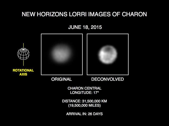
These recent images show the discovery of significant surface details on Pluto's largest moon, Charon. They were taken by the New Horizons Long Range Reconnaissance Imager (LORRI) on June 18, 2015. The image on the left is the original image, displayed at four times the native LORRI image size. After applying a technique that sharpens an image called deconvolution, details become visible on Charon, including a distinct dark pole. Deconvolution can occasionally introduce "false" details, so the finest details in these pictures will need to be confirmed by images taken from closer range in the next few weeks. http://photojournal.jpl.nasa.gov/catalog/PIA19690
Presented here are side-by-side comparisons of a traditional Cassini Synthetic Aperture Radar (SAR) view, at left, and one made using a new technique for handling electronic noise that results in clearer views of Titan's surface, at right. The technique, called despeckling, produces images that can be easier for researchers to interpret. The terrain seen here is in the flow region named Leilah Fluctus (55 degrees north, 80 degrees west). With the speckle noise suppressed, the overall pattern of bright and dark in the scene becomes more apparent. In particular, cone-shaped features near lower right stand out, which could be alluvial analogues on Titan -- features produced by the action of rivers or floods. North is toward right in this image, which shows an area about 50 miles (80 kilometers) wide. http://photojournal.jpl.nasa.gov/catalog/PIA19054

This image was acquired on July 22, 2018 by NASA's Mars Reconnaissance Orbiter. Mars has recently been enveloped in dusty haze, but the sensitivity of HiRISE enabled imaging of surface features through a moderate level of haze. This image shows a fresh impact crater in the northern middle latitudes. A technique called "pixel binning" was needed to improve the signal, but it is still the highest-resolution image ever acquired at this location. Pixel binning combines information of adjacent detectors in a CCD camera sensor to create one single pixel in the recorded image. https://photojournal.jpl.nasa.gov/catalog/PIA22726

The NASA imaging processing technology, an advanced computer technique to enhance images sent to Earth in digital form by distant spacecraft, helped develop a new vision screening process. The Ocular Vision Screening system, an important step in preventing vision impairment, is a portable device designed especially to detect eye problems in children through the analysis of retinal reflexes.
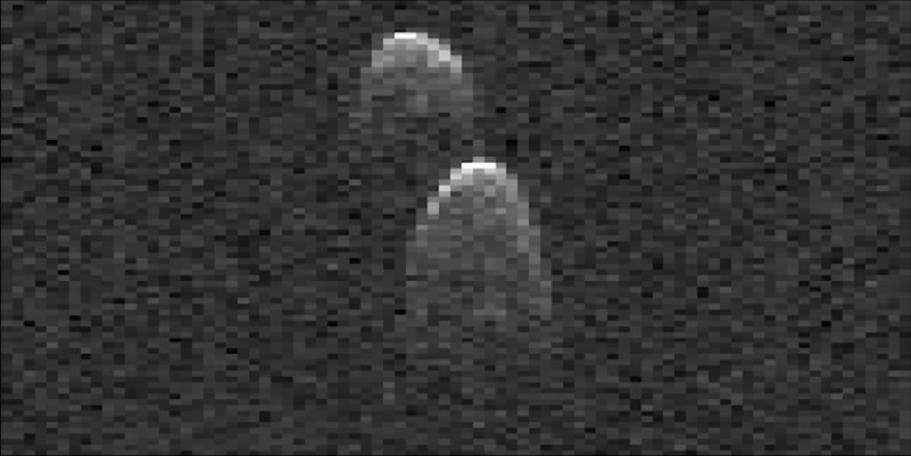
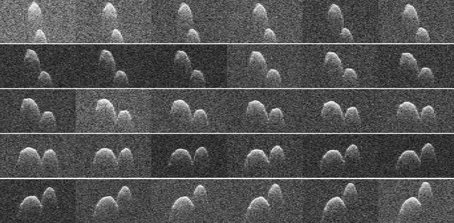
This frame from a movie made from radar images of asteroid 1999 JD6 was collected by NASA scientists on July 25, 2015. The images show the rotation of the asteroid, which made its closest approach on July 24 at 9:55 p.m. PDT (12:55 a.m. EDT on July 25) at a distance of about 4.5 million miles (7.2 million kilometers, or about 19 times the distance from Earth to the moon). The asteroid appears to be a contact binary -- an asteroid with two lobes that are stuck together. The radar images show the asteroid is highly elongated, with a length of approximately 1.2 miles (2 kilometers) on its long axis. These images are radar echoes, which are more like a sonogram than a photograph. The views were obtained by pairing NASA's 230-foot-wide (70-meter) Deep Space Network antenna at Goldstone, California, with the 330-foot (100-meter) National Science Foundation Green Bank Telescope in West Virginia. Using this approach, the Goldstone antenna beams a radar signal at an asteroid and Green Bank receives the reflections. The technique, referred to as a bistatic observation, dramatically improves the amount of detail that can be seen in radar images. The new views obtained with the technique show features as small as about 25 feet (7.5 meters) wide. http://photojournal.jpl.nasa.gov/catalog/PIA19646

jsc2012e039800_alt (5 March 2012) --- This is a composite of a series of images photographed from a mounted camera on the Earth-orbiting International Space Station, from approximately 240 miles above Earth. Expedition 31 Flight Engineer Don Pettit relayed some information about photographic techniques used to achieve the images: "My star trail images are made by taking a time exposure of about 10 to 15 minutes. However, with modern digital cameras, 30 seconds is about the longest exposure possible, due to electronic detector noise effectively snowing out the image. To achieve the longer exposures I do what many amateur astronomers do. I take multiple 30-second exposures, then
This collage of radar images of near-Earth asteroid 1999 JD6 was collected by NASA scientists on July 25, 2015. The images show the rotation of the asteroid, which made its closest approach on July 24 at 9:55 p.m. PDT (12:55 a.m. EDT on July 25) at a distance of about 4.5 million miles (7.2 million kilometers, or about 19 times the distance from Earth to the moon). The asteroid appears to be a contact binary -- an asteroid with two lobes that are stuck together. These views, which are radar echoes, were obtained by pairing NASA's 230-foot-wide (70-meter) Deep Space Network antenna at Goldstone, California, with the 330-foot (100-meter) National Science Foundation Green Bank Telescope in West Virginia. Using this approach, the Goldstone antenna beams a radar signal at an asteroid and Green Bank receives the reflections. The technique, referred to as a bistatic observation, dramatically improves the amount of detail that can be seen in radar images. The new views obtained with the technique show features as small as about 25 feet (7.5 meters) wide. The images show the asteroid is highly elongated, with a length of approximately 1.2 miles (2 kilometers) on its long axis. http://photojournal.jpl.nasa.gov/catalog/PIA19647
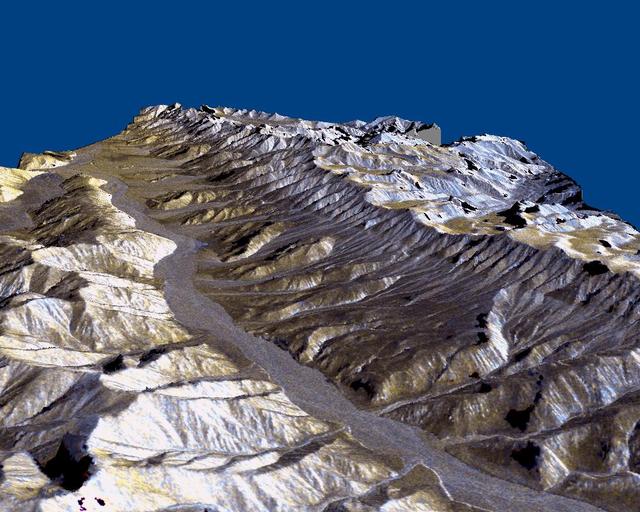
This three-dimensional perspective of the remote Karakax Valley in the northern Tibetan Plateau of western China was created by combining two spaceborne radar images using a technique known as interferometry. Visualizations like this are helpful to scientists because they reveal where the slopes of the valley are cut by erosion, as well as the accumulations of gravel deposits at the base of the mountains. These gravel deposits, called alluvial fans, are a common landform in desert regions that scientists are mapping in order to learn more about Earth's past climate changes. Higher up the valley side is a clear break in the slope, running straight, just below the ridge line. This is the trace of the Altyn Tagh fault, which is much longer than California's San Andreas fault. Geophysicists are studying this fault for clues it may be able to give them about large faults. Elevations range from 4000 m (13,100 ft) in the valley to over 6000 m (19,700 ft) at the peaks of the glaciated Kun Lun mountains running from the front right towards the back. Scale varies in this perspective view, but the area is about 20 km (12 miles) wide in the middle of the image, and there is no vertical exaggeration. http://photojournal.jpl.nasa.gov/catalog/PIA01800
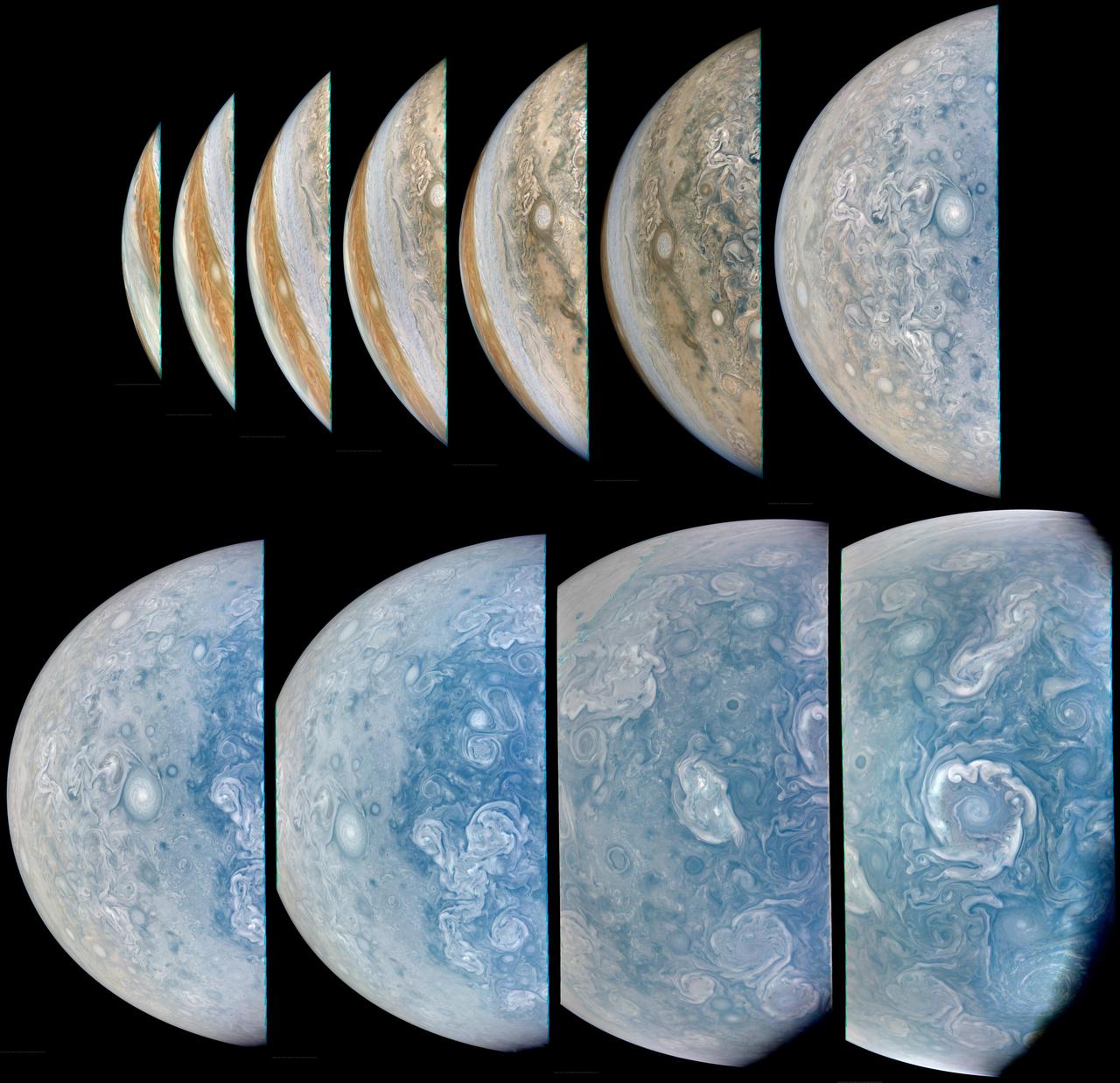
During its 65th close flyby of Jupiter on Sept. 20, 2024, NASA's Juno spacecraft captured this series of images as it approached the giant planet and swung low over its north polar region. Juno's recent orbits have provided exceptionally clear views of Jupiter's circumpolar cyclones. At closest approach in this series of images, the Juno spacecraft was about 6,800 miles (11,000 kilometers) above the cloud tops, at a latitude of 82 degrees north of the equator. Citizen scientist Brian Swift made this image using raw data from the JunoCam instrument, applying digital processing techniques to enhance color and clarity. https://photojournal.jpl.nasa.gov/catalog/PIA25730
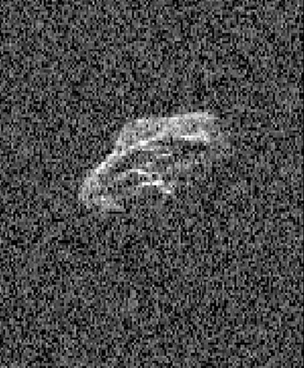
Scientists using two giant, Earth-based radio telescopes bounced radar signals off passing asteroid 2011 UW158 to create images for this animation showing the rocky body's fast rotation. The passing asteroid made its closest approach to Earth on July 19, 2015 at 7:37 a.m. PST (4:37 a.m. EST) at a distance of about 1.5 million miles (2.4 million kilometers, or 6 times the distance from Earth to the moon). The close proximity during the pass made 2011 UW158 one of the best asteroid flybys of 2015 for imaging from Earth using radar. The radar images reveal that the shape of the asteroid is extremely irregular and quite elongated. Prominent parallel, linear features run along the length of the object that cause a large increase in brightness of the radar images as they rotate into view. Scientists note that the asteroid appears to be fairly unusual. Its fast rotation suggests the object has greater mechanical strength than other asteroids its size. A fast-rotating asteroid with lower mechanical strength would tend to split apart. To obtain the views, researchers paired the 230-foot- (70-meter-) wide Deep Space Network antenna at Goldstone, California, in concert with the National Radio Astronomy Observatory's 330-foot (100-meter) Green Bank Telescope. Using this technique, the Goldstone antenna beams a radar signal at an asteroid and Green Bank receives the reflections. The technique, referred to as a bi-static observation, dramatically improves the amount of detail that can be seen in radar images. The new views obtained with the technique show features as small as about 24 feet (7.5 meters) wide. The 171 individual images used in the movie were generated from data collected on July 18. They show the asteroid is approximately 2000 by 1000 feet (600 by 300 meters) across. The observations also confirm earlier estimates by astronomers that the asteroid rotates quickly, completing one spin in just over half an hour. The movie spans a period of about an hour and 45 minutes. The trajectory of asteroid 2011 UW158 is well understood. This flyby was the closest approach the asteroid will make to Earth for at least the next 93 years. Asteroid 2011 UW158 was discovered on October 25, 2011, by the PanSTARRS 1 telescope, located on the summit of Haleakala on Maui, Hawaii. Managed by the University of Hawaii, the PanSTARRS survey receives NASA funding. Radar is a powerful technique for studying an asteroid's size, shape, rotation state, surface features and surface roughness, and for improving the calculation of asteroid orbits. Radar measurements of asteroid distances and velocities often enable computation of asteroid orbits much further into the future than if radar observations weren't available. http://photojournal.jpl.nasa.gov/catalog/PIA19644
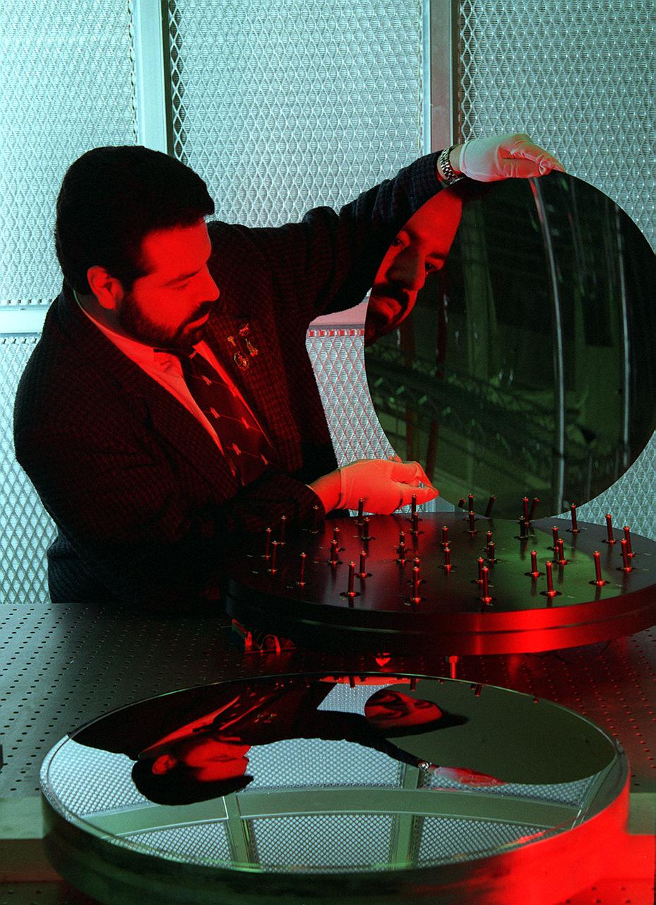
NASA's Space Optics Manufacturing Center has been working to expand our view of the universe via sophisticated new telescopes. The Optics Center's goal is to develop low-cost, advanced space optics technologies for the NASA program in the 21st century - including the long-term goal of imaging Earth-like planets in distant solar systems. To reduce the cost of mirror fabrication, Marshall Space Flight Center (MSFC) has developed replication techniques, the machinery, and materials to replicate electro-formed nickel mirrors. The process allows fabricating precisely shaped mandrels to be used and reused as masters for replicating high-quality mirrors. Dr. Joe Ritter examines a replicated electro-formed nickel-alloy mirror which exemplifies the improvements in mirror fabrication techniques, with benefits such as dramtic weight reduction that have been achieved at the Marshall Space Flight Center's Space Optics Manufacturing Technology Center (SOMTC).

This image of galaxy cluster Abell 2744, also called Pandora's Cluster, was taken by the Spitzer Space Telescope. The gravity of this galaxy cluster is strong enough that it acts as a lens to magnify images of more distant background galaxies. This technique is called gravitational lensing. The fuzzy blobs in this Spitzer image are the massive galaxies at the core of this cluster, but astronomers will be poring over the images in search of the faint streaks of light created where the cluster magnifies a distant background galaxy. The cluster is also being studied by NASA's Hubble Space Telescope and Chandra X-Ray Observatory in a collaboration called the Frontier Fields project. In this image, light from Spitzer's infrared channels is colored blue at 3.6 microns and green at 4.5 microns. http://photojournal.jpl.nasa.gov/catalog/PIA20920
A test version of Orion is recovered from the Pacific Ocean using a crane on board the Navy's USS Salvor during tests on Sept. 12, 2014. A combined NASA and U.S. Navy team practiced recovery techniques off the coast of California over the course of the next week -- first with the crane, as seen here, then using the USS Anchorage's well deck -- in preparation for Exploration Flight Test-1 (EFT-1). Part of Batch image transfer from Flickr.
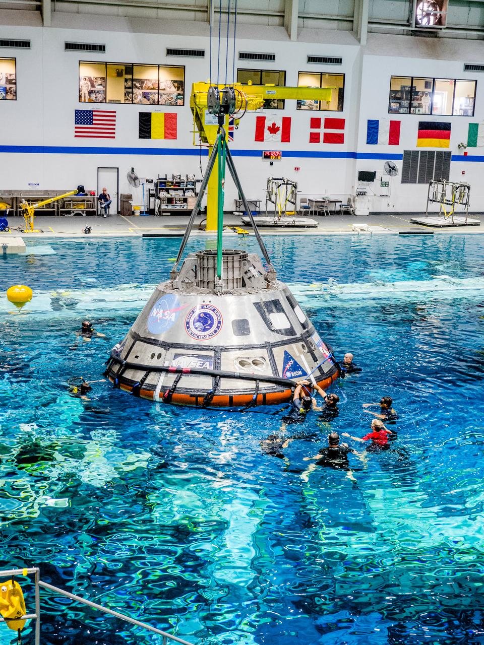
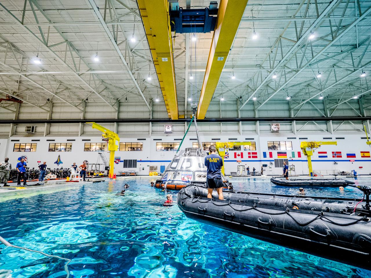
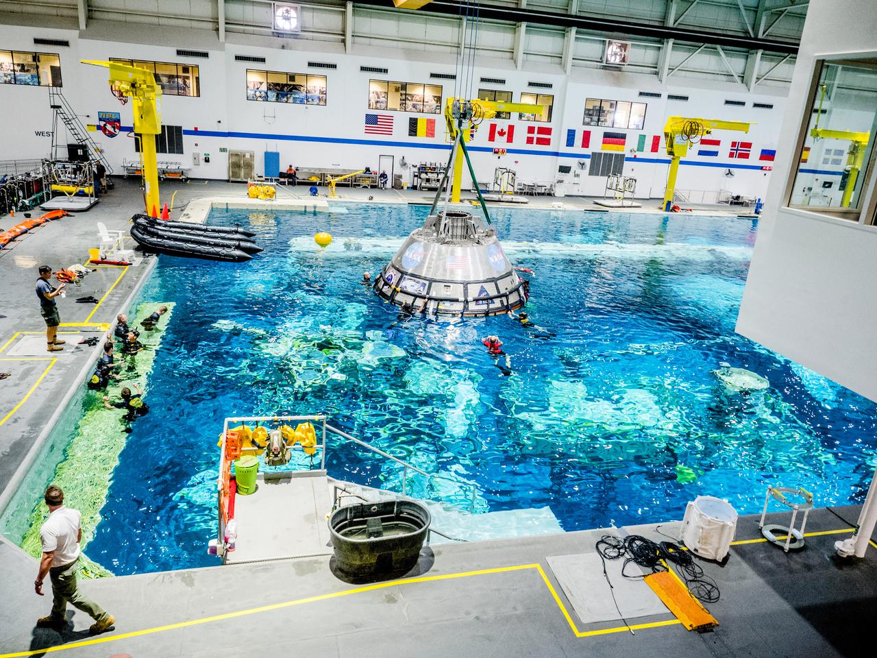
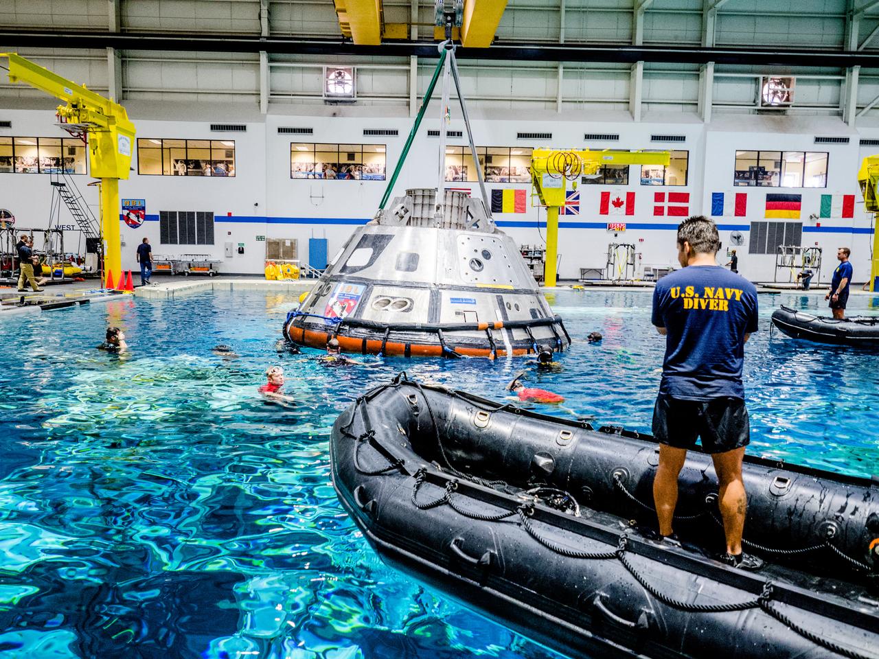
A group of U.S. Navy divers, Air Force pararescumen and Coast Guard rescue swimmers practice Orion underway recovery techniques this week in the Neutral Buoyancy Laboratory (NBL) at NASA’s Johnson Space Center in Houston on Sept. 21, 2016, to prepare for the first test flight of an uncrewed Orion spacecraft with the agency’s Space Launch System rocket during Artemis I. Part of Batch image transfer from Flickr.
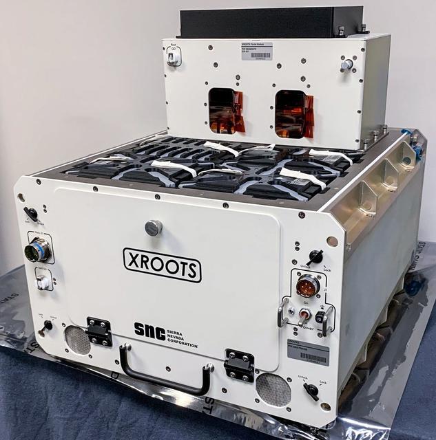
jsc2021e037285 (2/12/2021) --- A preflight view of the XROOTS hardware. The eXposed Root On-Orbit Test System (XROOTS) investigation uses hydroponic and aeroponic techniques to grow plants without soil or other growth media. Video and still images enable evaluation of multiple independent growth chambers for the entire plant life cycle from seed germination through maturity. Results could identify suitable methods to produce crops on a larger scale for future space missions.
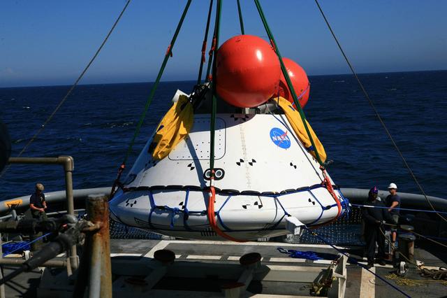
The NASA and US Navy recovery crews practice lifting the Orion boilerplate test article out of the water using a crane on the USS Anchorage on Aug. 3, 2014. NASA and U.S. Navy practiced recovery techniques off the coast of California, in preparation for Exploration Flight Test-1 (EFT-1). Part of Batch image transfer from Flickr.
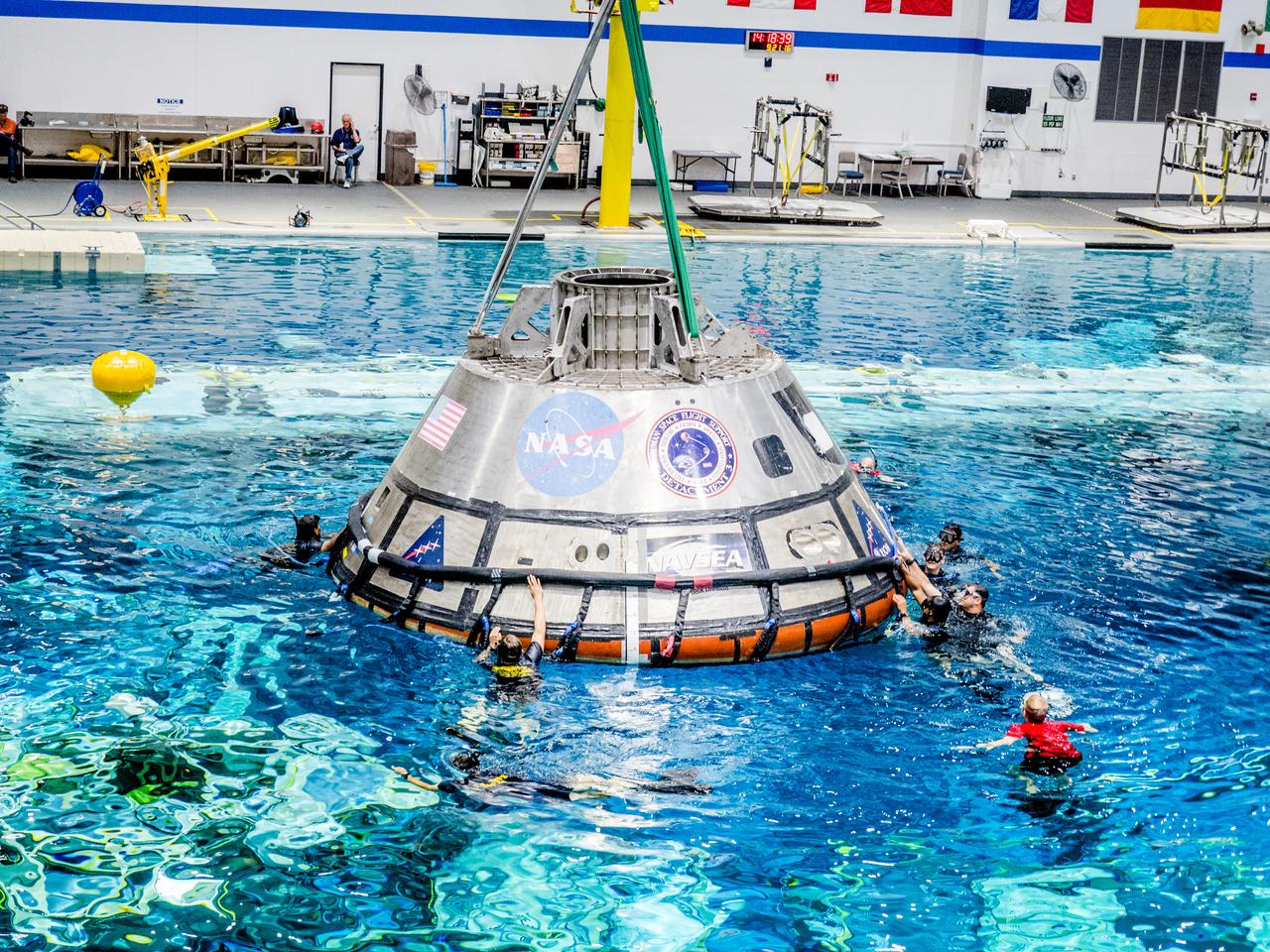
A group of U.S. Navy divers, Air Force pararescumen and Coast Guard rescue swimmers practice Orion underway recovery techniques this week in the Neutral Buoyancy Laboratory (NBL) at NASA’s Johnson Space Center in Houston on Sept. 21, 2016, to prepare for the first test flight of an uncrewed Orion spacecraft with the agency’s Space Launch System rocket during Artemis I. Part of Batch images transfer from Flickr.
Recovery team members work secure a test version of Orion in preparation for tests aboard the USS Salvor on Sept. 12, 2014. A combined NASA and U.S. Navy team practiced recovery techniques off the coast of California over the course of the next week -- first with the crane, as seen here, then using the USS Anchorage's well deck -- in preparation for Exploration Flight Test-1 (EFT-1). Part of Batch image transfer from Flickr.
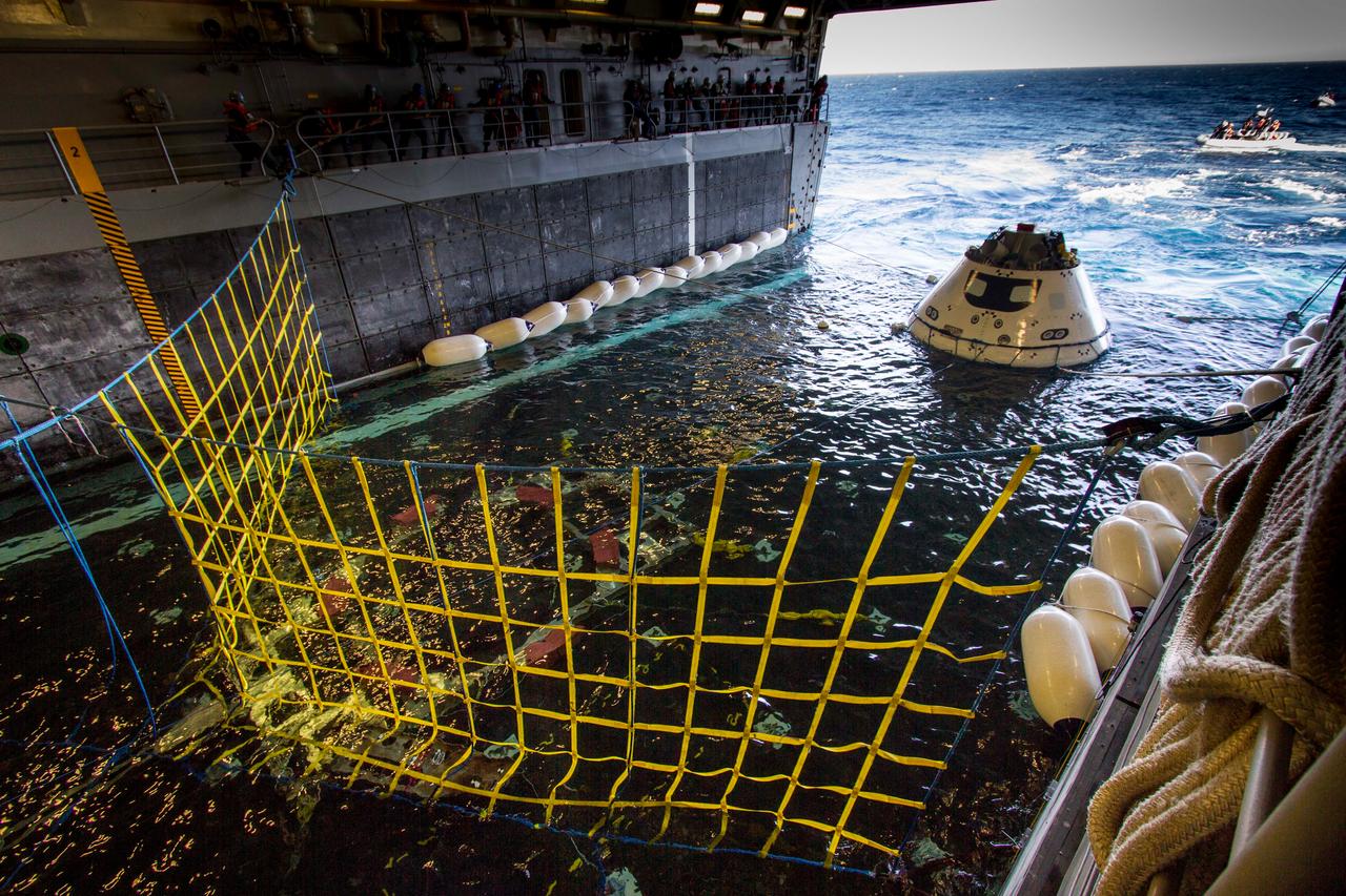
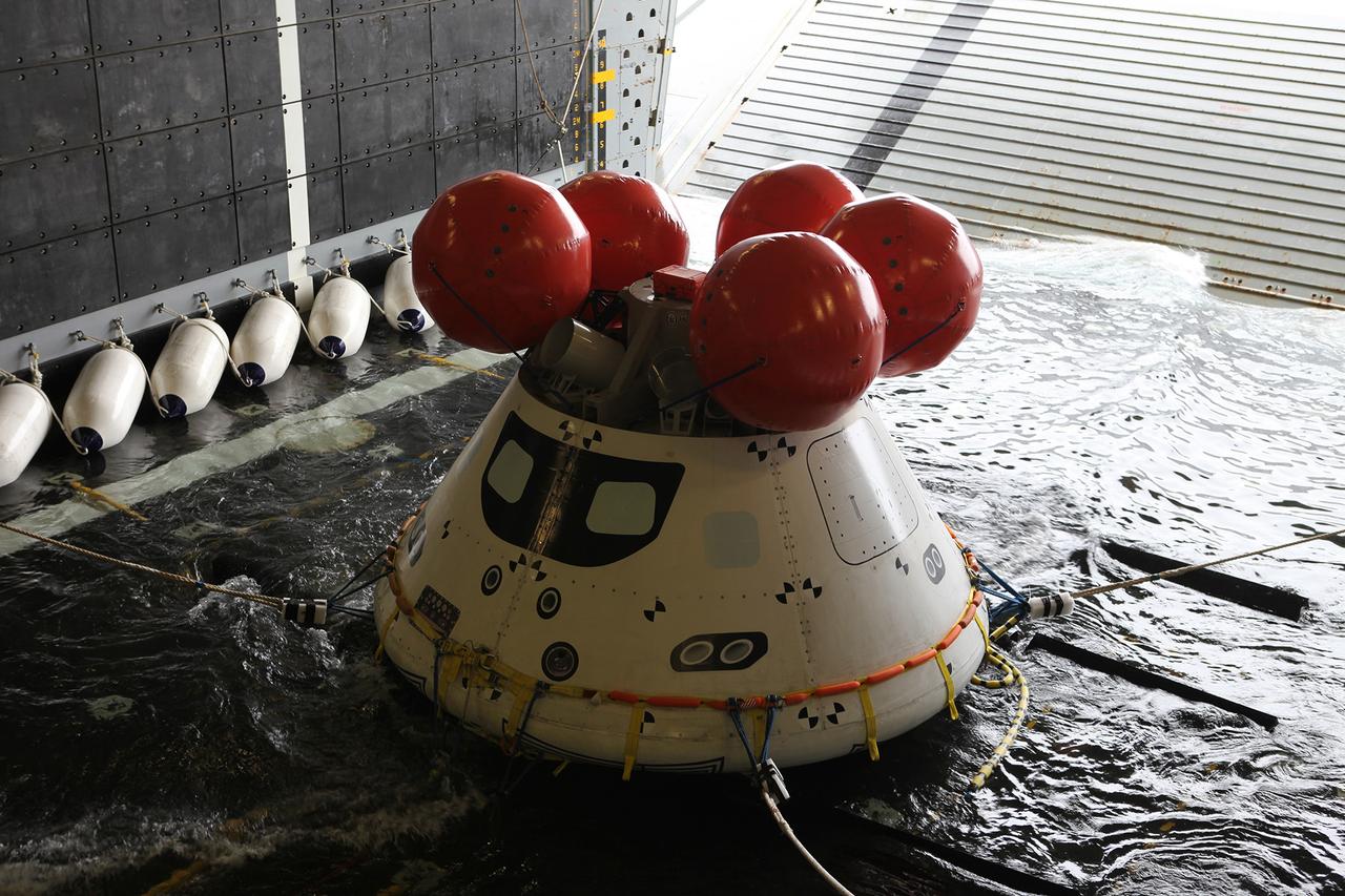
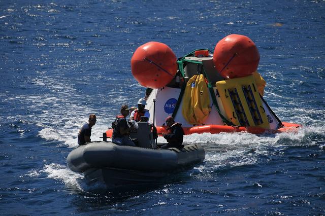
A test version of Orion floats into the well deck of the Navy's USS Anchorage during recovery tests off the coast of California on Sept. 15, 2014. The well deck can be flooded with water to allow Orion to float in, and then drained when the spacecraft is secured. A combined NASA and U.S. Navy team has been practicing recovery techniques in preparation for Exploration Flight Test-1 (EFT-1). Part of Batch image transfer from Flickr.
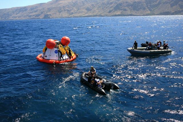
Recovery team members secure a test version of Orion in the Pacific Ocean on Sept. 12, 2014. A combined NASA and U.S. Navy team practiced recovery techniques off the coast of California over the course of the next week -- first with the crane, as seen here, then using the USS Anchorage's well deck -- in preparation for Exploration Flight Test-1 (EFT-1). Part of Batch image transfer from Flickr.

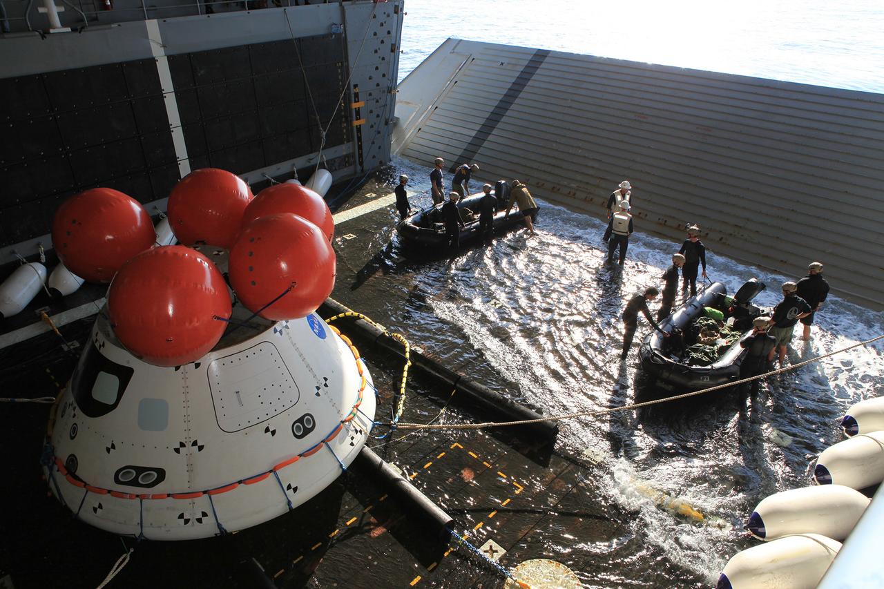
Recovery team members work to guide a test version of Orion into the USS Anchorage's well deck on Sept. 15, 2014. NASA and the Navy are working together this week to test tools and techniques that will be used to recover the spacecraft once it splashes down following Exploration Flight Test-1 (EFT-1). Part of Batch image transfer from Flickr.
A group of U.S. Navy divers, Air Force pararescumen and Coast Guard rescue swimmers practice Orion underway recovery techniques this week in the Neutral Buoyancy Laboratory (NBL) at NASA’s Johnson Space Center in Houston on Sept. 21, 2016, to prepare for the first test flight of an uncrewed Orion spacecraft with the agency’s Space Launch System rocket during Artemis I. Part of Batch images transfer from Flickr.
A group of U.S. Navy divers, Air Force pararescumen and Coast Guard rescue swimmers practice Orion underway recovery techniques this week in the Neutral Buoyancy Laboratory (NBL) at NASA’s Johnson Space Center in Houston on Sept. 21, 2016, to prepare for the first test flight of an uncrewed Orion spacecraft with the agency’s Space Launch System rocket during Artemis I. Part of Batch images transfer from Flickr.
Recovery team members work on a test version of Orion in the Pacific Ocean on Sept. 13, 2014. A combined NASA and U.S. Navy team practiced recovery techniques off the coast of California over the course of the the week -- first with a crane on board the Navy's USS Salvor, then using the USS Anchorage's well deck -- in preparation for Exploration Flight Test-1 (EFT-1). Part of Batch image transfer from Flickr.
Recovery team members lower a test version of Orion into the Pacific Ocean using a crane on board the Navy's USS Salvor on Sept. 13, 2014. A combined NASA and U.S. Navy team practiced recovery techniques off the coast of California over the course of the next week -- first with the crane, as seen here, then using the USS Anchorage's well deck -- in preparation for Exploration Flight Test-1 (EFT-1). Part of Batch image transfer from Flickr.
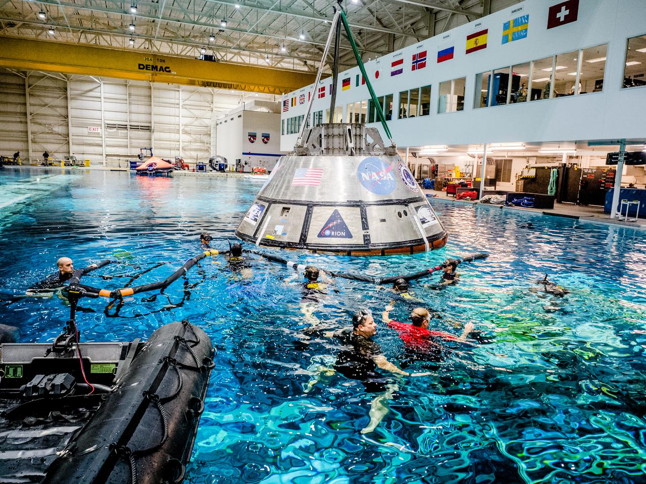
A group of U.S. Navy divers, Air Force pararescumen and Coast Guard rescue swimmers practice Orion underway recovery techniques this week in the Neutral Buoyancy Laboratory (NBL) at NASA’s Johnson Space Center in Houston on Sept. 21, 2016, to prepare for the first test flight of an uncrewed Orion spacecraft with the agency’s Space Launch System rocket during Artemis I. Part of Batch image transfer from Flickr.

Recovery team members use a crane to lift a test version of Orion off the deck of the Navy's USS Salvor on Sept. 13, 2014. A combined NASA and U.S. Navy team practiced recovery techniques off the coast of California over the course of the next week -- first with the crane, as seen here, then using the USS Anchorage's well deck -- in preparation for Exploration Flight Test-1 (EFT-1). Part of Batch image transfer from Flickr.
Recovery team members attach cables to a test version of Orion on Sept. 12, 2014. A combined NASA and U.S. Navy team practiced recovery techniques off the coast of California over the course of the next week -- first with the crane, as seen here, then using the USS Anchorage's well deck -- in preparation for Exploration Flight Test-1 (EFT-1). Part of Batch image transfer from Flickr.
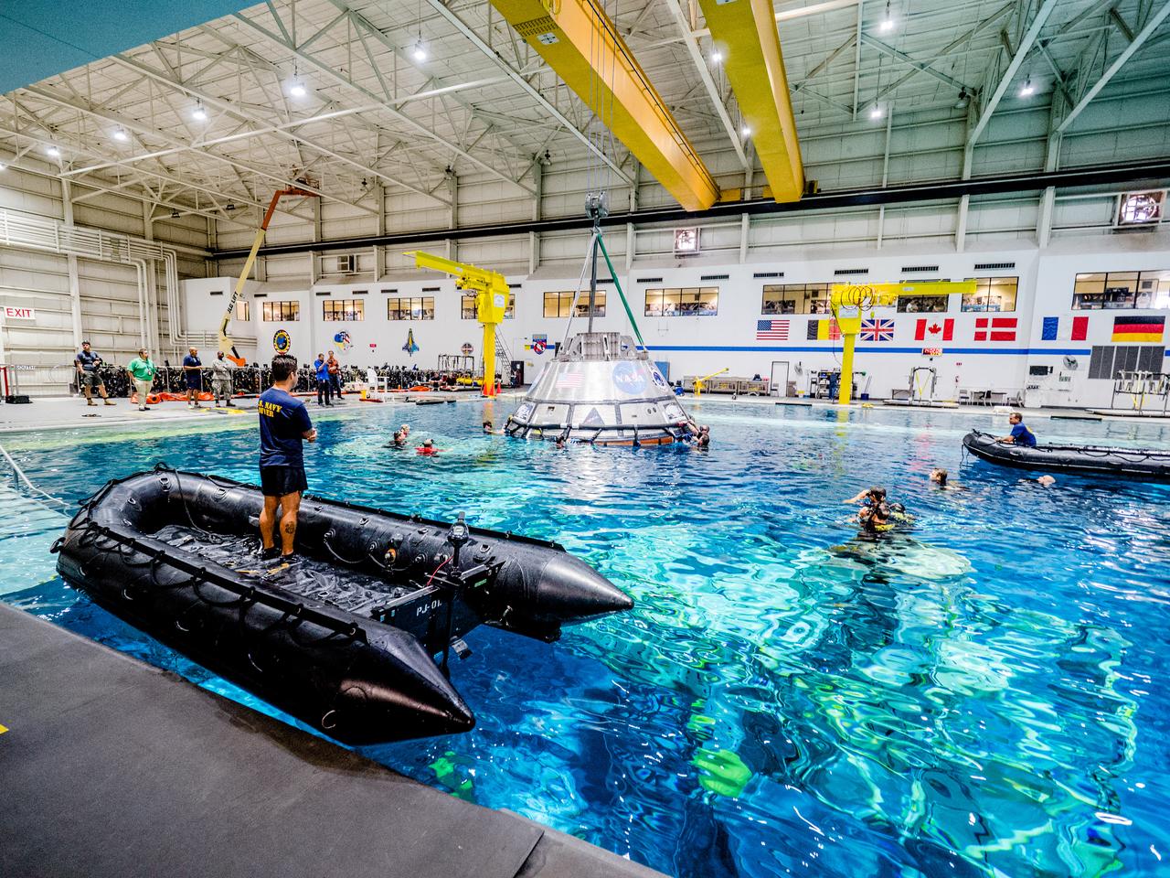
A group of U.S. Navy divers, Air Force pararescumen and Coast Guard rescue swimmers practice Orion underway recovery techniques this week in the Neutral Buoyancy Laboratory (NBL) at NASA’s Johnson Space Center in Houston on Sept. 21, 2016, to prepare for the first test flight of an uncrewed Orion spacecraft with the agency’s Space Launch System rocket during Artemis I.Part of Batch image transfer from Flickr.
Recovery team members observe from inside the USS Anchorage's well deck as a test version of Orion is reeled in from the Pacific Ocean on Sept. 17, 2014, during a test of tools and techniques that will be used to retrieve the spacecraft once it splashes down following Exploration Flight Test-1 (EFT-1). Part of Batch image transfer from Flickr.
Recovery team members move away from a test version of Orion ready to be recovered from the Pacific Ocean on Sept. 13, 2014. A combined NASA and U.S. Navy team practiced recovery techniques off the coast of California over the course of the the week -- first with a crane on board the Navy's USS Salvor, then using the USS Anchorage's well deck -- in preparation for Exploration Flight Test-1 (EFT-1). Part of Batch image transfer from Flickr.
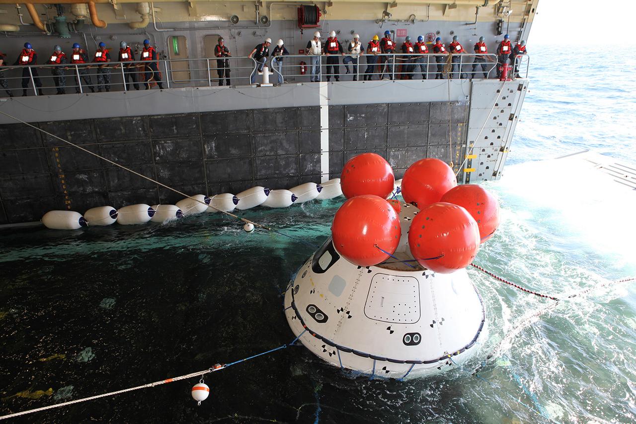
Recovery team members use ropes to hold a test version of Orion steady inside the USS Anchorage's well deck as it is reeled in from the Pacific Ocean on Sept. 17, 2014, during a test of tools and techniques that will be used to retrieve the spacecraft once it splashes down following Exploration Flight Test-1 (EFT-1). Part of Batch image transfer from Flickr.
JSC2005-E-30949 (2005) --- NASA engineers Dana Weigel and Lora Bailey, along with astronauts David Wolf and Joe Tanner and other engineers evaluate techniques to eliminate or trim protruding gap fillers as a possible contingency plan for an STS-114 extravehicular activity (EVA). Photo credit: NASA Note: This image does not appear on public sites

Recovery team members work to guide a test version of Orion into the USS Anchorage's well deck on Sept. 15, 2014. NASA and the Navy are working together to test tools and techniques that will be used to recover the spacecraft once it splashes down following Exploration Flight Test-1 (EFT-1). Part of Batch image transfer from Flickr.

Janice Hueschen of Innovative Imaging & Research Corp. at Stennis Space Center helps students from Benjamin E. Mays Preparatory School in New Orleans harvest lettuce at the INFINITY at NASA Stennis Space Center facility May 7, 2012. The Louisiana students assisted in the first harvest of lettuce from the Controlled Environment Agriculture unit, which uses an aeroponic process that involves no soil and advance LED lighting techniques.
Recovery team members work to secure a test version of Orion in the Pacific Ocean on Sept. 17, 2014. A combined NASA and U.S. Navy team is practicing recovery techniques off the coast of California over the course of the the week -- first with a crane on board the Navy's USS Salvor, and now using the USS Anchorage's well deck -- in preparation for Exploration Flight Test-1 (EFT-1). Part of Batch image transfer from Flickr.
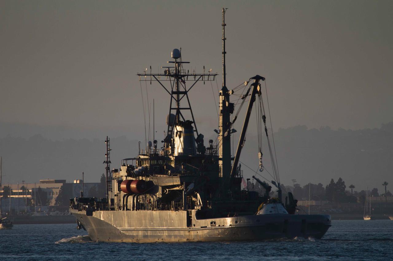
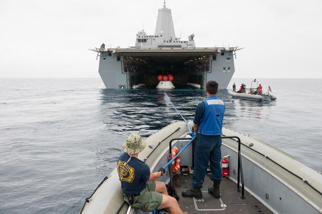
The Navy's USS Salvor makes its way out to sea with a test version of Orion on deck on Sept. 12, 2014. NASA and Navy personnel on board the Salvor used the ship's crane to test recovery techniques prior to Orion's first launch on Exploration Flight Test-1 (EFT-1). Part of Batch image transfer from Flickr.
Recovery team members lower a test version of Orion onto the deck of the Navy's USS Salvor on Sept. 13, 2014. A combined NASA and U.S. Navy team is practiced recovery techniques off the coast of California over the course of the the week -- first with a crane on board the Salvor, then using the USS Anchorage's well deck -- in preparation for Exploration Flight Test-1 (EFT-1). Part of Batch image transfer from Flickr.
Recovery team members work on a test version of Orion in the Pacific Ocean on Sept. 13, 2014. A combined NASA and U.S. Navy team practiced recovery techniques off the coast of California over the course of the the week -- first with a crane on board the Navy's USS Salvor, then using the USS Anchorage's well deck -- in preparation for Exploration Flight Test-1 (EFT-1). Part of Batch image transfer from Flickr.
Recovery team members attach cables to a test version of Orion in the Pacific Ocean on Sept. 12, 2014. A combined NASA and U.S. Navy team practiced recovery techniques off the coast of California over the course of the next week -- first with the crane, as seen here, then using the USS Anchorage's well deck -- in preparation for Exploration Flight Test-1 (EFT-1). Part of Batch image transfer from Flickr.
Recovery team members retrieve a test version of Orion from the Pacific Ocean using a crane on the Navy's USS Salvor on Sept. 13, 2014. A combined NASA and U.S. Navy team practiced recovery techniques off the coast of California over the course of the the week -- first with the Salvor's crane, then using the USS Anchorage's well deck -- in preparation for Exploration Flight Test-1 (EFT-1). Part of Batch image transfer from Flickr.

Recovery team members attach cables to a test version of Orion in the Pacific Ocean on Sept. 12, 2014. A combined NASA and U.S. Navy team practiced recovery techniques off the coast of California over the course of the next week -- first with the crane, as seen here, then using the USS Anchorage's well deck -- in preparation for Exploration Flight Test-1 (EFT-1). Part of Batch image transfer from Flickr.
A recovery team members prepares a test version of Orion to be lifted off the deck of the Navy's USS Salvor on Sept. 13, 2014. A combined NASA and U.S. Navy team practiced recovery techniques off the coast of California over the course of the next week -- first with the crane, as seen here, then using the USS Anchorage's well deck -- in preparation for Exploration Flight Test-1 (EFT-1). Part of Batch image transfer from Flickr.
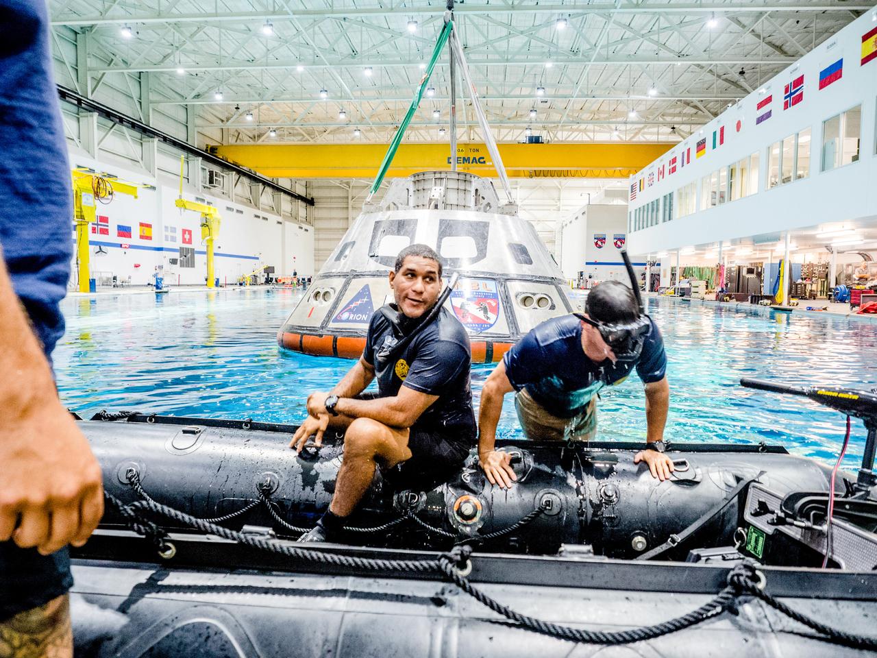
A group of U.S. Navy divers, Air Force pararescumen and Coast Guard rescue swimmers practice Orion underway recovery techniques this week in the Neutral Buoyancy Laboratory (NBL) at NASA’s Johnson Space Center in Houston on Sept. 21, 2016, to prepare for the first test flight of an uncrewed Orion spacecraft with the agency’s Space Launch System rocket during Artemis I. Part of Batch image transfer from Flickr.
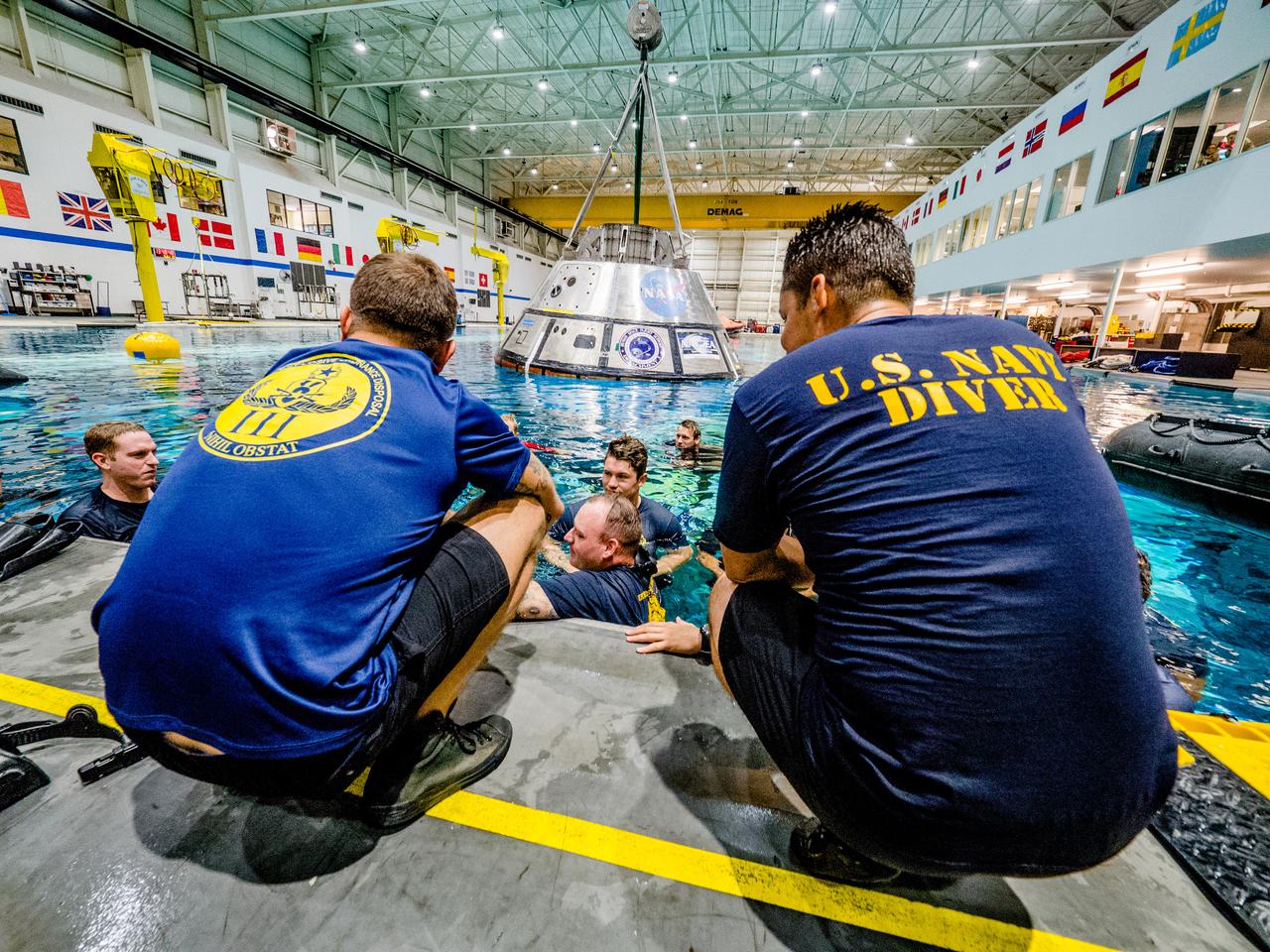
A group of U.S. Navy divers, Air Force pararescumen and Coast Guard rescue swimmers practice Orion underway recovery techniques this week in the Neutral Buoyancy Laboratory (NBL) at NASA’s Johnson Space Center in Houston on Sept. 21, 2016, to prepare for the first test flight of an uncrewed Orion spacecraft with the agency’s Space Launch System rocket during Artemis I. Part of Batch images transfer from Flickr.
A test version of Orion is recovered from the Pacific Ocean using a crane on board the Navy's USS Salvor during tests on Sept. 12, 2014. A combined NASA and U.S. Navy team practiced recovery techniques off the coast of California over the course of the next week -- first with the crane, as seen here, then using the USS Anchorage's well deck -- in preparation for Exploration Flight Test-1 (EFT-1). Part of Batch image transfer from Flickr.
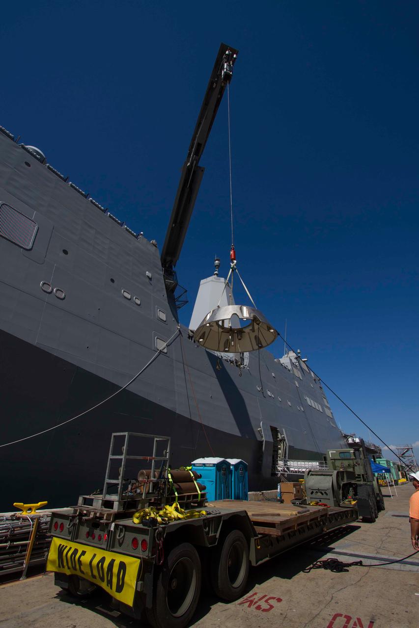
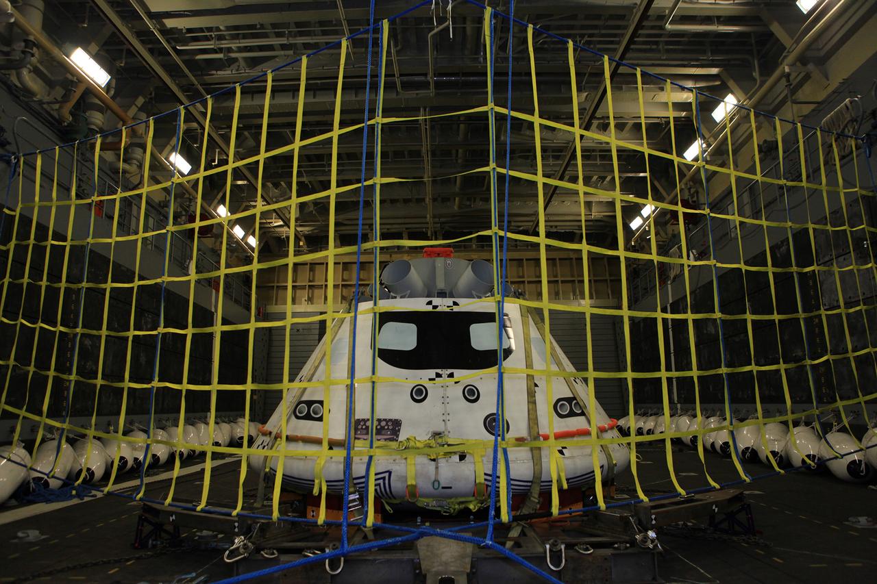
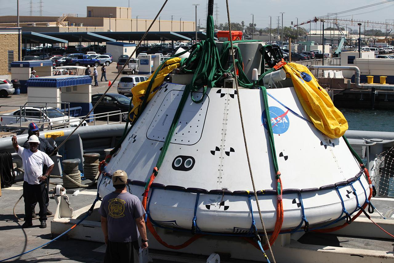
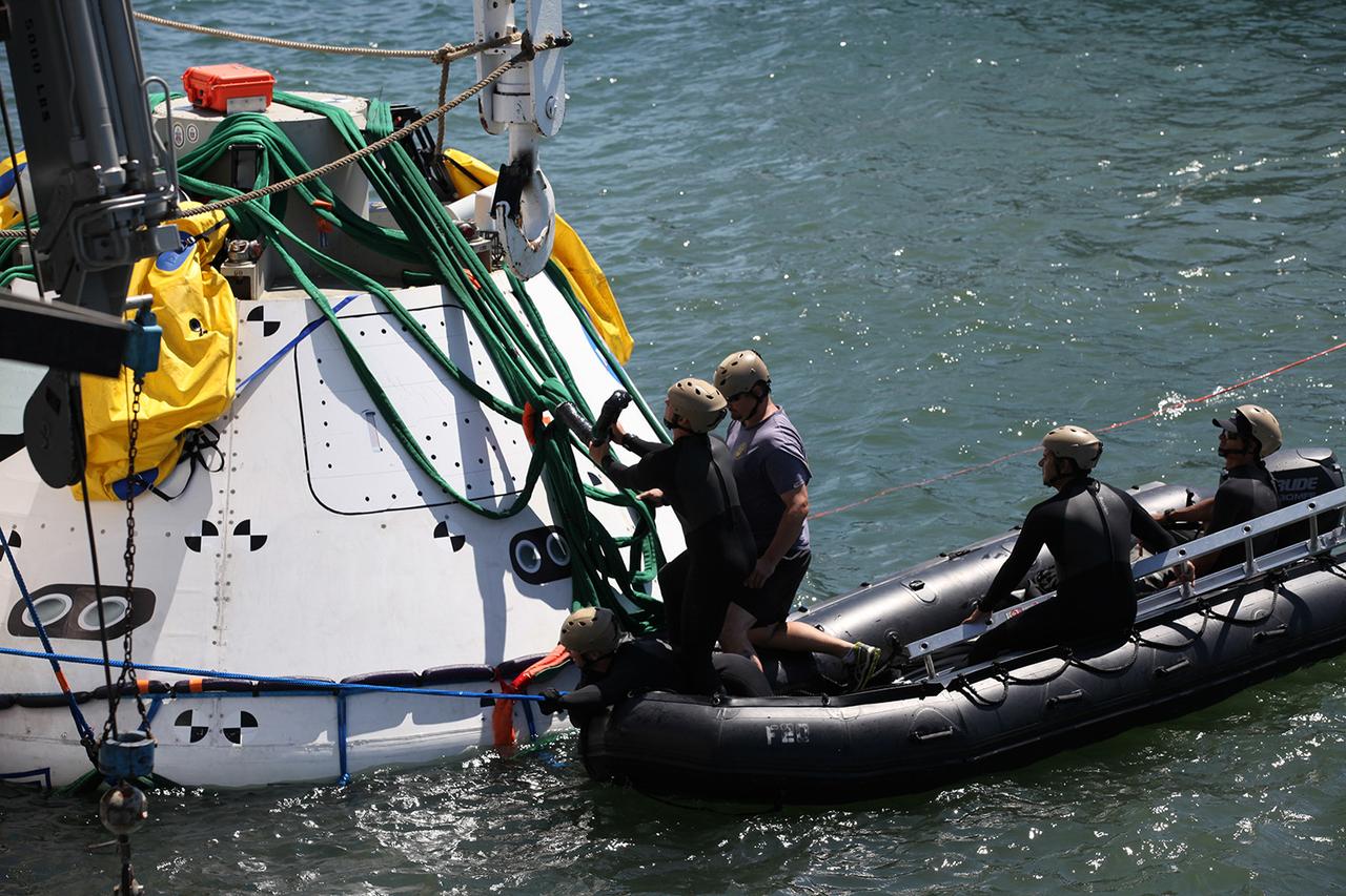
A test version of Orion's forward bay cover is loaded onto the Navy's USS Anchorage in preparation for testing Orion recovery tools and techniques in the Pacific Ocean off the coast of San Diego on Sept. 12, 2014. The forward bay cover protects the top section of Orion's crew module until the spacecraft is almost ready to land. It is jettisoned to allow Orion's parachutes to deploy and must be recovered separately from the crew module. Part of Batch image transfer from Flickr.
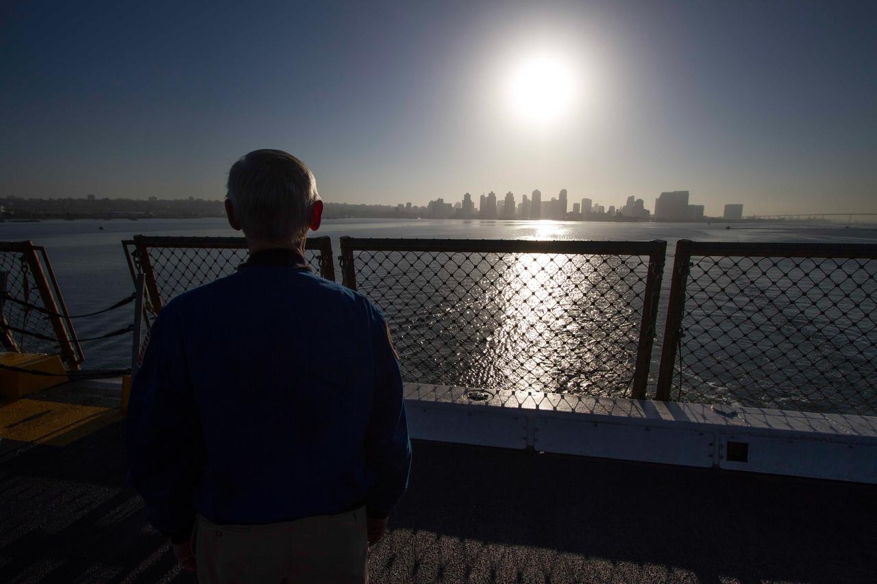
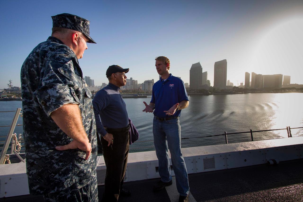
Former astronaut and Special Assistant for Orion Program Integration John Casper watches the San Diego skyline grow smaller in the distance as the Navy's USS Anchorage heads out to sea on Sept. 15, 2014. The ship is being used to test Orion recovery tools and techniques prior to Exploration Flight Test-1 (EFT-1). Part of Batch image transfer from Flickr.
Recovery team members use a crane to lift a test version of Orion off the deck of the Navy's USS Salvor on Sept. 13, 2014. A combined NASA and U.S. Navy team practiced recovery techniques off the coast of California over the course of the next week -- first with the crane, as seen here, then using the USS Anchorage's well deck -- in preparation for Exploration Flight Test-1 (EFT-1). Part of Batch image transfer from Flickr.
A group of U.S. Navy divers, Air Force pararescumen and Coast Guard rescue swimmers practice Orion underway recovery techniques this week in the Neutral Buoyancy Laboratory (NBL) at NASA’s Johnson Space Center in Houston on Sept. 21, 2016, to prepare for the first test flight of an uncrewed Orion spacecraft with the agency’s Space Launch System rocket during Artemis I.Part of Batch image transfer from Flickr.
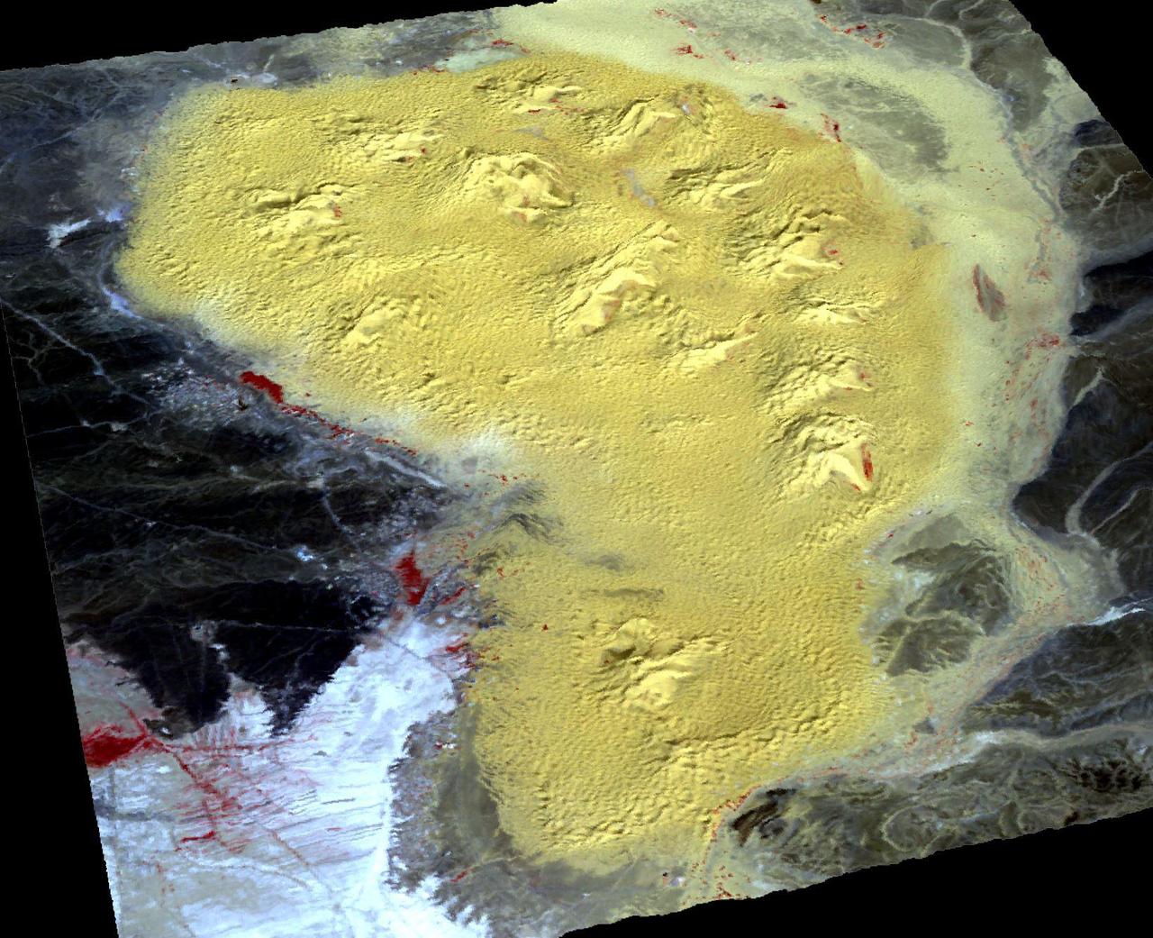
For the first time scientists have calculated the age of star dunes (or pyramid dunes). Some of the tallest – over 100 m high – are located in the Erg Chebbi sand sea in southeast Morocco. Using luminescence dating techniques, the dunes were found to have formed over 13,000 years ago. The perspective view has 5X vertical exaggeration. The image was acquired October 2, 2020, covers an area of 13.5 by 20.4 km, and is located at 31.2 degrees north, 4 degrees west. https://photojournal.jpl.nasa.gov/catalog/PIA26287

jsc2019e040132 (3/10/2015) --- Preflight image of silica, a common element used in tires to help enhance performance in areas such as fuel efficiency and wet traction. The Pushing the Limits of Silica Fillers for Tire Applications (Goodyear Tire) investigation evaluates creation of novel silica forms and structures, or morphologies, using traditional techniques to form silica fillers in microgravity. The space environment may yield results not possible in ground-based environments. Better understanding of silica morphology and the relationship between silica structure and properties may improve the silica design process as well as silica rubber formulation and tire manufacturing and performance on the ground. (Image courtesy of: The Goodyear Tire & Rubber Company)

The high-tech art of digital signal processing (DSP) was pioneered at NASA's Jet Propulsion Laboratory (JPL) in the mid-1960s for use in the Apollo Lunar Landing Program. Designed to computer enhance pictures of the Moon, this technology became the basis for the Landsat Earth resources satellites and subsequently has been incorporated into a broad range of Earthbound medical and diagnostic tools. DSP is employed in advanced body imaging techniques including Computer-Aided Tomography, also known as CT and CATScan, and Magnetic Resonance Imaging (MRI). CT images are collected by irradiating a thin slice of the body with a fan-shaped x-ray beam from a number of directions around the body's perimeter. A tomographic (slice-like) picture is reconstructed from these multiple views by a computer. MRI employs a magnetic field and radio waves, rather than x-rays, to create images.

The high-tech art of digital signal processing (DSP) was pioneered at NASA's Jet Propulsion Laboratory (JPL) in the mid-1960s for use in the Apollo Lunar Landing Program. Designed to computer enhance pictures of the Moon, this technology became the basis for the Landsat Earth resources satellites and subsequently has been incorporated into a broad range of Earthbound medical and diagnostic tools. DSP is employed in advanced body imaging techniques including Computer-Aided Tomography, also known as CT and CATScan, and Magnetic Resonance Imaging (MRI). CT images are collected by irradiating a thin slice of the body with a fan-shaped x-ray beam from a number of directions around the body's perimeter. A tomographic (slice-like) picture is reconstructed from these multiple views by a computer. MRI employs a magnetic field and radio waves, rather than x-rays, to create images. In this photograph, a patient undergoes an open MRI.

The high-tech art of digital signal processing (DSP) was pioneered at NASA's Jet Propulsion Laboratory (JPL) in the mid-1960s for use in the Apollo Lunar Landing Program. Designed to computer enhance pictures of the Moon, this technology became the basis for the Landsat Earth resources satellites and subsequently has been incorporated into a broad range of Earthbound medical and diagnostic tools. DSP is employed in advanced body imaging techniques including Computer-Aided Tomography, also known as CT and CATScan, and Magnetic Resonance Imaging (MRI). CT images are collected by irradiating a thin slice of the body with a fan-shaped x-ray beam from a number of directions around the body's perimeter. A tomographic (slice-like) picture is reconstructed from these multiple views by a computer. MRI employs a magnetic field and radio waves, rather than x-rays, to create images.

The high-tech art of digital signal processing (DSP) was pioneered at NASA's Jet Propulsion Laboratory (JPL) in the mid-1960s for use in the Apollo Lunar Landing Program. Designed to computer enhance pictures of the Moon, this technology became the basis for the Landsat Earth resources satellites and subsequently has been incorporated into a broad range of Earthbound medical and diagnostic tools. DSP is employed in advanced body imaging techniques including Computer-Aided Tomography, also known as CT and CATScan, and Magnetic Resonance Imaging (MRI). CT images are collected by irradiating a thin slice of the body with a fan-shaped x-ray beam from a number of directions around the body's perimeter. A tomographic (slice-like) picture is reconstructed from these multiple views by a computer. MRI employs a magnetic field and radio waves, rather than x-rays, to create images.
P-29506BW Range: 1.12 million kilometers (690,000 miles) This high-resolution image of the epsilon ring of Uranus is a clear-filter picture from Voyager's narrow-angle camera and has a resolution of about 10 km (6 mi). The epsilon ring, approx. 100 km (60 mi) wide at this location, clearly shows a structural variation. Visible here are a broad, bright outer component about 40 km (25 mi) wide; a darker, middle region of comparable width; and a narrow, bright inner strip about 15 km (9 mi) wide. The epsilon-ring structure seen by Voyager is similiar to that observed from the ground with stellar-occultation techniques. This frame represents the first Voyager image that resolves these features within the epsilon ring. The occasional fuzzy splotches on the outer and innerparts of the ring are artifacts left by the removal of reseau marks (used for making measurements on the image).