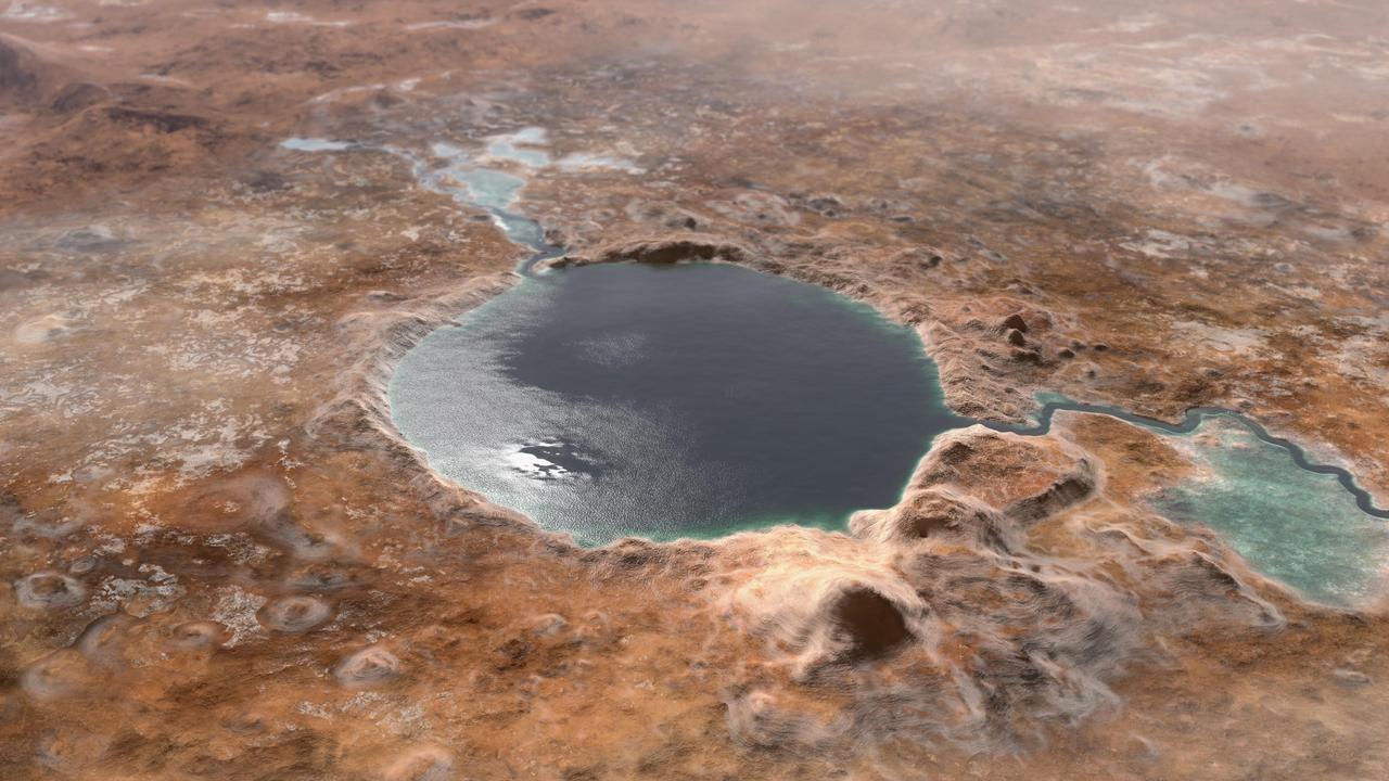
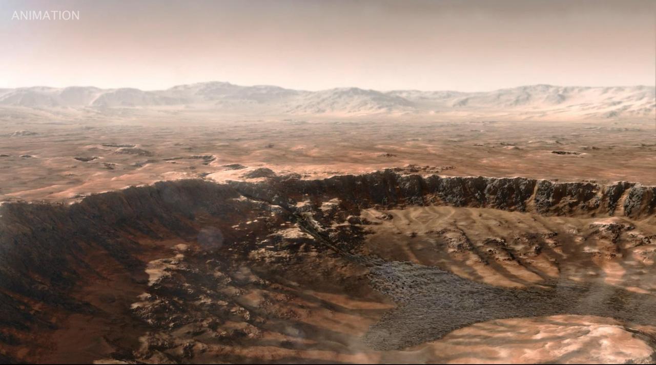
This illustration shows Jezero Crater — the landing site of the Mars 2020 Perseverance rover — as it may have looked billions of years go on Mars, when it was a lake. An inlet and outlet are also visible on either side of the lake. A key objective for Perseverance's mission on Mars is astrobiology, including the search for signs of ancient microbial life. The rover will characterize the planet's geology and past climate, pave the way for human exploration of the Red Planet, and be the first mission to collect and cache Martian rock and regolith (broken rock and dust). Subsequent missions, currently under consideration by NASA in cooperation with the European Space Agency, would send spacecraft to Mars to collect these cached samples from the surface and return them to Earth for in-depth analysis. https://photojournal.jpl.nasa.gov/catalog/PIA24172
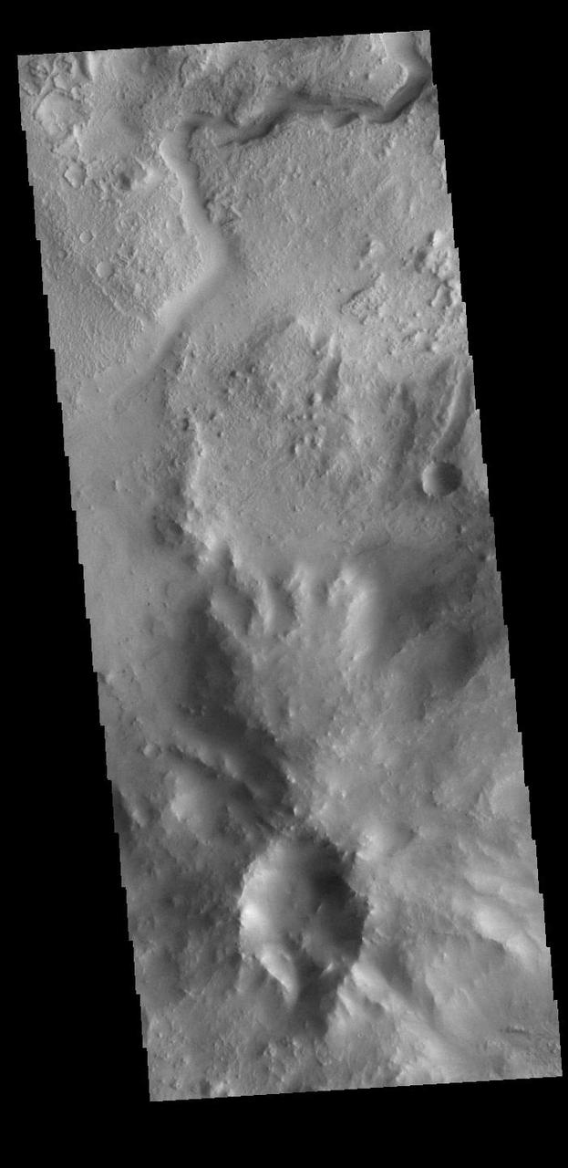
On the left side of today's VIS image is the Jezero Crater delta deposit. This feature was created by the flow from the rim channel into the crater. Deltas form when sediments settle out due to a decrease in speed of a river system. Deltas often form where large rivers flow into the ocean, like the Mississippi and Nile deltas. This can also occur where rivers flow into large lakes, such as the Great Salt Lake and Lake St. Clair river deltas. It is believed that the Jezero Crater delta formed this way. Jezero Crater is the home of the Mars 2020 rover – Perseverance – and its little helicopter buddy – Ingenuity. The Mars 2020 mission is focused on the delta, and the information it holds about a time when Mars was much wetter. Orbit Number: 95046 Latitude: 18.449 Longitude: 77.436 Instrument: VIS Captured: 2023-05-19 09:28 https://photojournal.jpl.nasa.gov/catalog/PIA26252
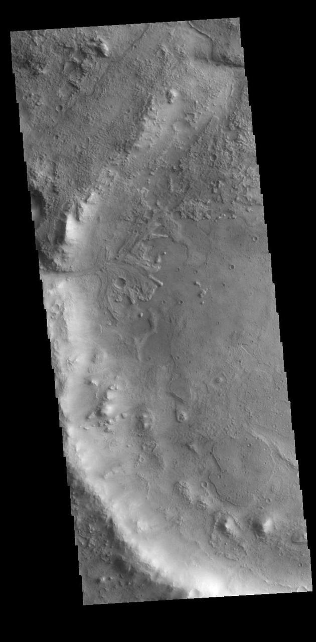
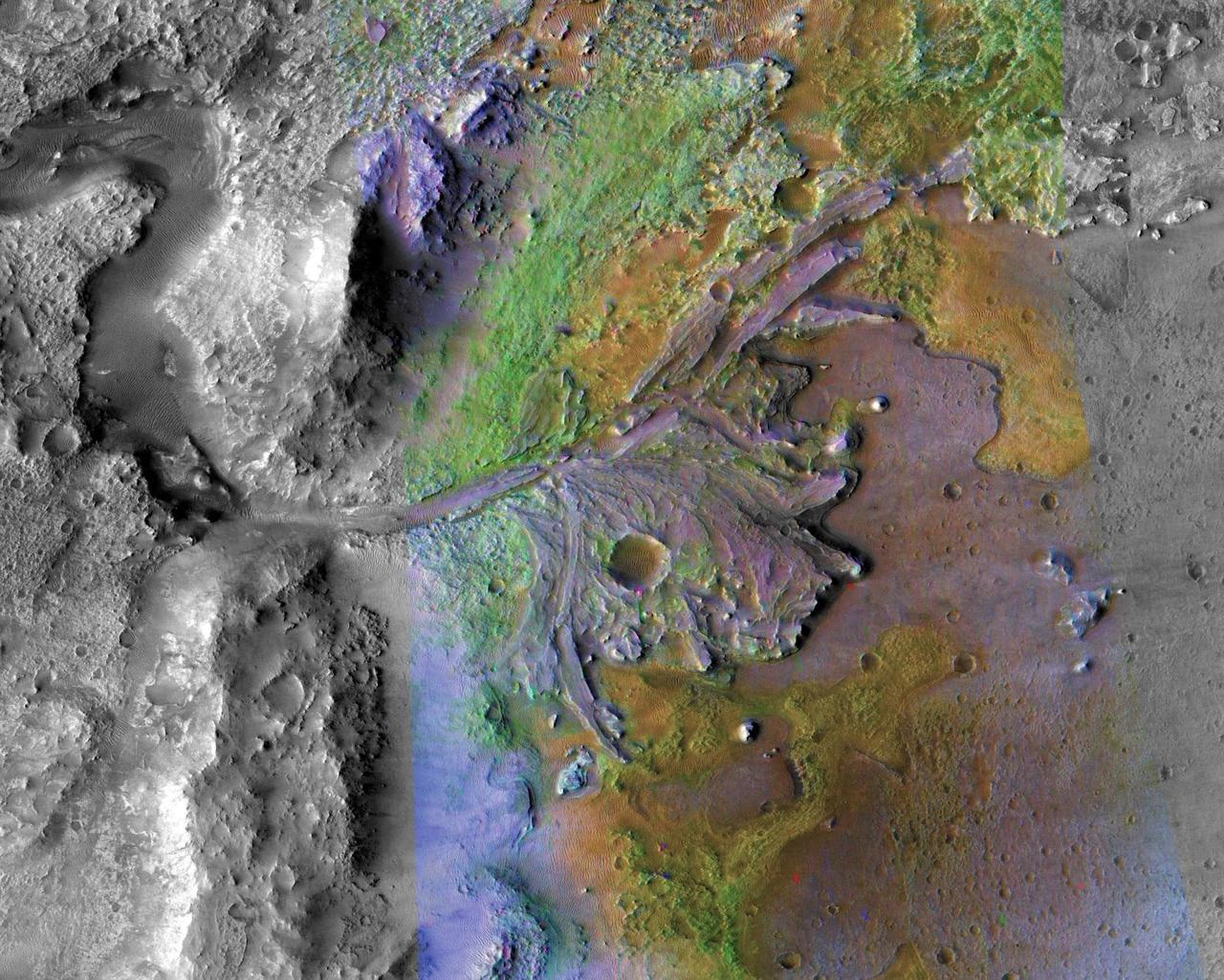
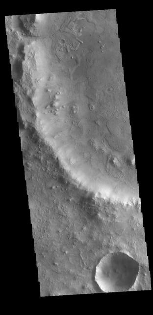
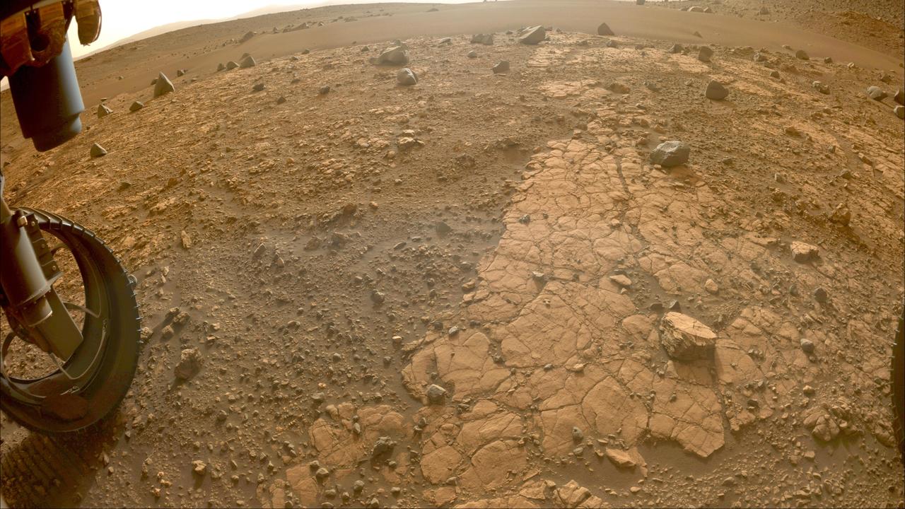
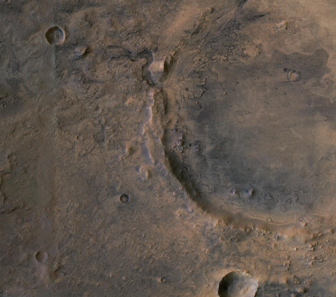
Today's VIS image shows part of the northeastern portion of Jezero Crater. The Perserverance Rover is located on the northwestern part of the crater – near a delta deposit formed by the influx of silt laden water into the crater at a time during Mars' past that was wetter. The crater most likely hosted a lake for a period of time. The channel at the top of this image was formed by the flow of water exiting the crater. Orbit Number: 89206 Latitude: 18.3845 Longitude: 78.1952 Instrument: VIS Captured: 2022-01-23 12:45 https://photojournal.jpl.nasa.gov/catalog/PIA25350

Today's VIS image shows part of the northeastern rim of Jezero Crater. The Perserverance Rover is located on the northwestern part of the crater – near a delta deposit formed by the influx of silt laden water into the crater at a time during Mars' past that was wetter. The crater most likely hosted a lake for a period of time. The channel in the center of this image was formed by the flow of water exiting the crater. Orbit Number: 93804 Latitude: 18.3721 Longitude: 78.2125 Instrument: VIS Captured: 2023-02-06 03:55 https://photojournal.jpl.nasa.gov/catalog/PIA25903
This animation, constructed using stereo imaging data from the High Resolution Imaging Science Experiment (HiRISE) camera on NASA's Mars Reconnaissance Orbiter, provides an airborne perspective of the Mars 2020 landing site and its exploration area at Jezero Crater. Mars 2020 is expected to land to the southeast of an ancient river delta, a fan-shaped feature inside the northeast rim of Jezero Crater that provides solid evidence of a river and lake system active in and around the crater billions of years ago. The solid white line on the surface indicates a path the rover could take during its prime mission. Animation available at https://photojournal.jpl.nasa.gov/catalog/PIA22905
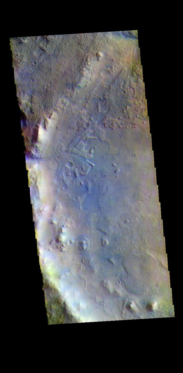
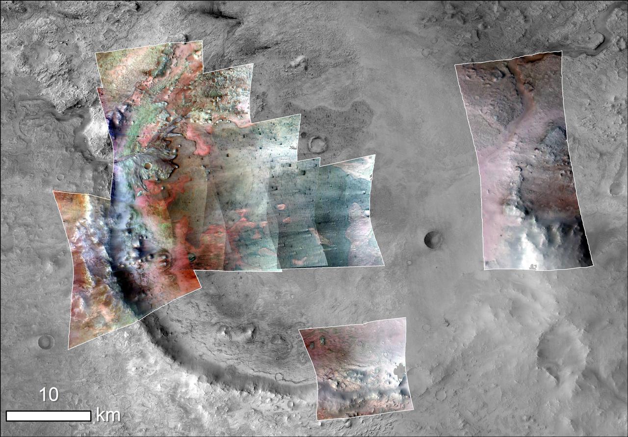
The THEMIS VIS camera contains 5 filters. The data from different filters can be combined in multiple ways to create a false color image. These false color images may reveal subtle variations of the surface not easily identified in a single band image. Today's false color image shows the western half of Jezero Crater. The Perserverance Rover is located in this part of the crater – near the delta deposit formed by the influx of silt laden water into the crater at a time during Mars' past that was wetter. The crater most likely hosted a lake for a period of time. Jezero Crater is 47km (29 miles) in diameter. The THEMIS VIS camera is capable of capturing color images of the Martian surface using five different color filters. In this mode of operation, the spatial resolution and coverage of the image must be reduced to accommodate the additional data volume produced from using multiple filters. To make a color image, three of the five filter images (each in grayscale) are selected. Each is contrast enhanced and then converted to a red, green, or blue intensity image. These three images are then combined to produce a full color, single image. Because the THEMIS color filters don't span the full range of colors seen by the human eye, a color THEMIS image does not represent true color. Also, because each single-filter image is contrast enhanced before inclusion in the three-color image, the apparent color variation of the scene is exaggerated. Nevertheless, the color variation that does appear is representative of some change in color, however subtle, in the actual scene. Note that the long edges of THEMIS color images typically contain color artifacts that do not represent surface variation. Orbit Number: 95046 Latitude: 18.449 Longitude: 77.436 Instrument: VIS Captured: 2023-05-19 09:28 https://photojournal.jpl.nasa.gov/catalog/PIA26140
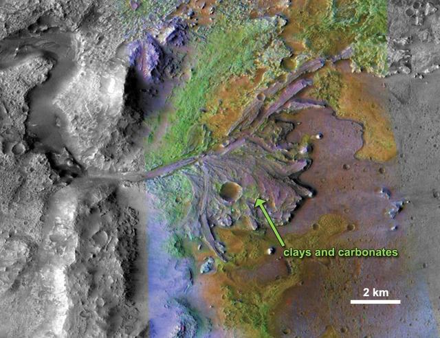
This image is of Jezero Crater on Mars, the landing site for NASA's Mars 2020 mission. It was taken by instruments on NASA's Mars Reconnaissance Orbiter (MRO), which regularly takes images of potential landing sites for future missions. On ancient Mars, water carved channels and transported sediments to form fans and deltas within lake basins. Examination of spectral data acquired from orbit show that some of these sediments have minerals that indicate chemical alteration by water. Here in Jezero Crater delta, sediments contain clays and carbonates. https://photojournal.jpl.nasa.gov/catalog/PIA23239

This image shows a possible landing site for the 2020 Mission: Jezero Crater, as seen by NASA Mars Reconnaissance Orbiter. It's not only when trying to find a scientifically interesting place to land that the high-resolution images from HiRISE come in handy: it's also to identify potential hazards within a landing ellipse. This is one of the trickier aspects of selecting landing sites on Mars: a place to do good science but also where the risks of landing are low. Jezero Crater is an ancient crater where clay minerals have been detected, and with a delta deposit indicating that water was once flowing into a lake. Since clays form the in presence of water, this crater would be a very good candidate for a lander to explore and build on what we've learned from the Mars Science Laboratory. Could some form of ancient life have existed here and for how long? http://photojournal.jpl.nasa.gov/catalog/PIA19303
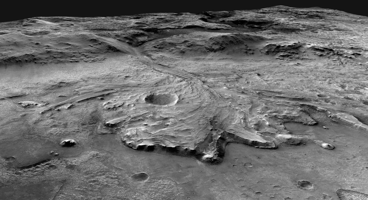
This illustration depicts a possible area through which the Mars 2020 Perseverance rover could traverse across Jezero Crater as it investigates several ancient environments that may have once been habitable. The route begins at the cliffs defining the base of a delta produced by a river as it flowed into a lake that once filled the crater. The path then traverses up and across the delta toward possible ancient shoreline deposits, and then climbs the 2,000-foot-high (610-meter-high) crater rim to explore the surrounding plains. About half of this traverse could be completed in Perseverance's prime mission (one Mars year, or two Earth years). For reference, the prominent crater near the center of the image is about 0.6 miles (1 kilometer) across. This mosaic is composed of multiple precisely aligned images from the Context Camera on the Mars Reconnaissance Orbiter and has a resolution of 20 meet (6 meters) per pixel. https://photojournal.jpl.nasa.gov/catalog/PIA24310
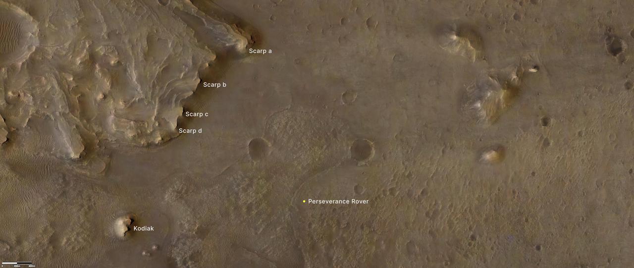
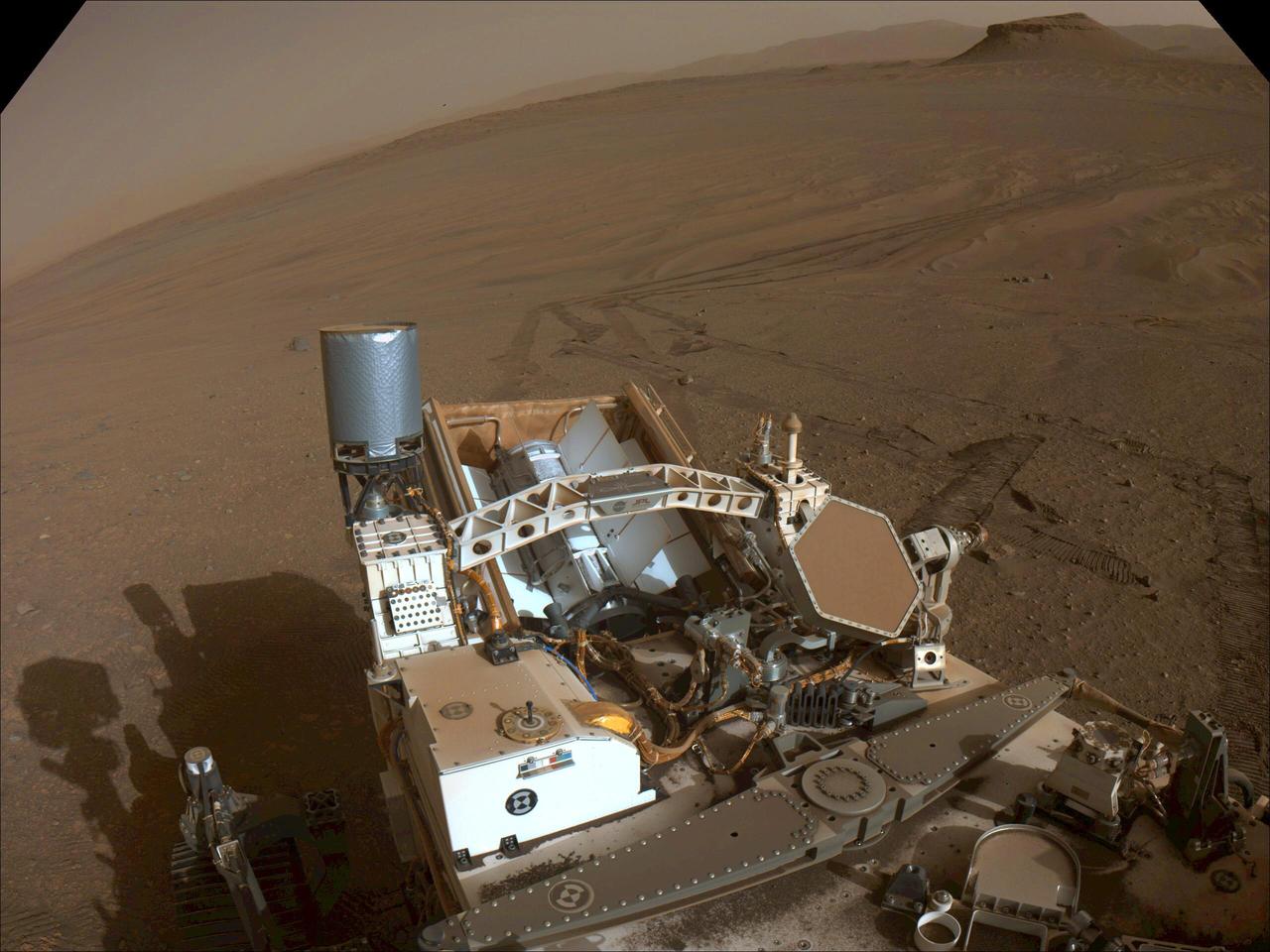
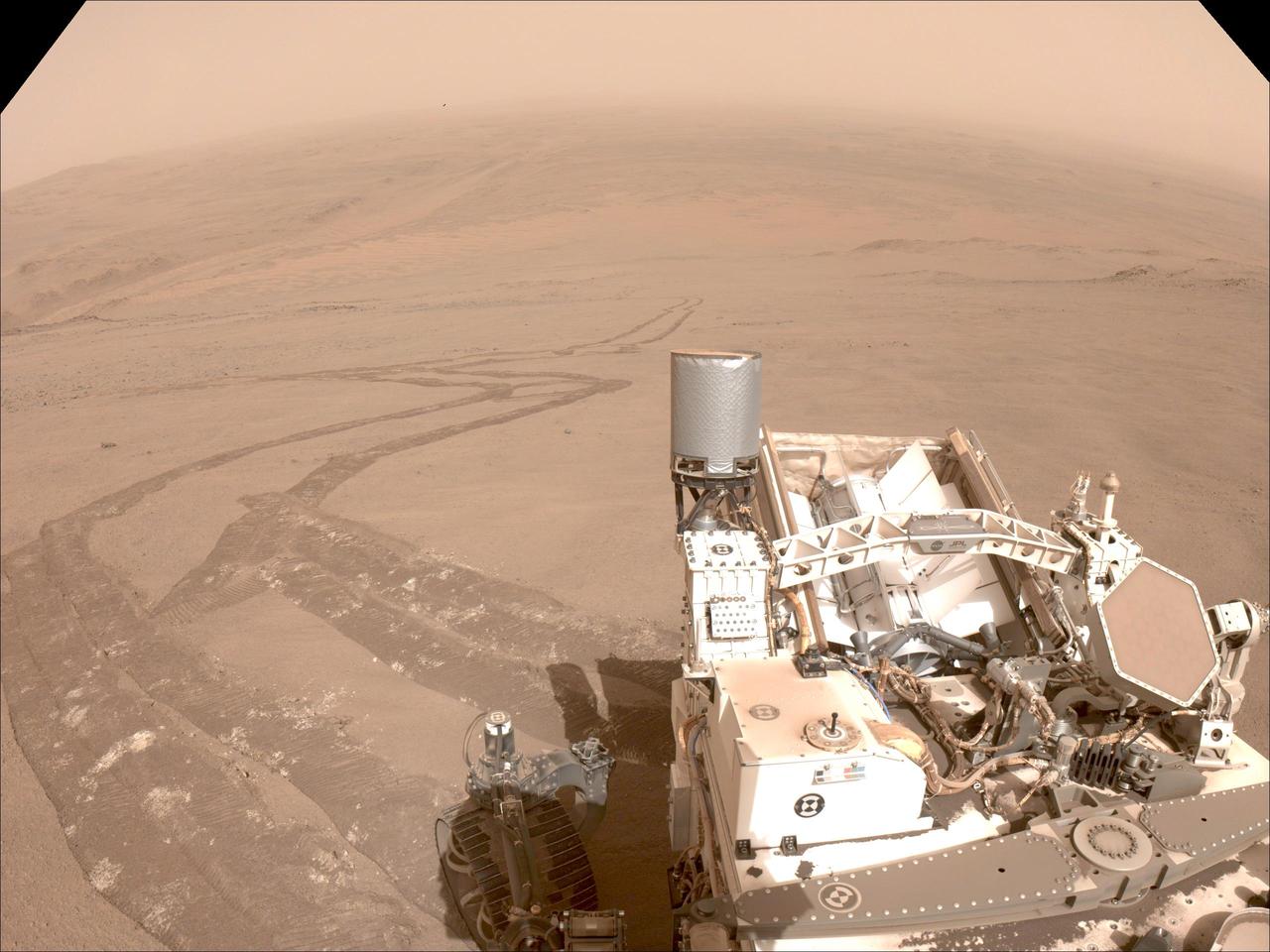
Provided by the High Resolution Imaging Experiment (HiRISE) aboard NASA's Mars Reconnaissance orbiter, this overhead image captures a portion of Mars' Jezero Crater. The yellow dot on lower right indicates the location of NASA's Perseverance rover. The remnant of Jezero Crater's rover delta the science team refers to as "Kodiak" is to the lower left. Long, steep slopes, called scarps, along the delta are on the upper left, labeled A through D. The University of Arizona, in Tucson, operates HiRISE, which was built by Ball Aerospace & Technologies Corp., in Boulder, Colorado. NASA's Jet Propulsion Laboratory, a division of Caltech in Pasadena, California, manages the Mars Reconnaissance Orbiter Project for NASA's Science Mission Directorate, Washington. A key objective for Perseverance's mission on Mars is astrobiology, including the search for signs of ancient microbial life. The rover will characterize the planet's geology and past climate, pave the way for human exploration of the Red Planet, and be the first mission to collect and cache Martian rock and regolith. The Mars 2020 Perseverance mission is part of NASA's Moon to Mars exploration approach, which includes Artemis missions to the Moon that will help prepare for human exploration of the Red Planet. Subsequent NASA missions, in cooperation with ESA (European Space Agency), would send spacecraft to Mars to collect these sealed samples from the surface and return them to Earth for in-depth analysis. https://photojournal.jpl.nasa.gov/catalog/PIA24814
At the top of today's VIS image is a delta deposit that was created by the flow from the rim channel into the crater. Deltas form when sediments settle out due to a decrease in speed of a river system. Deltas often form where large rivers flow into the ocean, like the Mississippi and Nile deltas. This can also occur where rivers flow into large lakes, such as the Great Salt Lake and Lake St. Clair river deltas. It is believed that the Jezero Crater delta formed this way. The delta in Jezero Crater has been chosen as the location for the Mars 2020 mission. Orbit Number: 77838 Latitude: 18.1853 Longitude: 77.4252 Instrument: VIS Captured: 2019-07-02 11:53 https://photojournal.jpl.nasa.gov/catalog/PIA23386
Color has been added to highlight minerals in this image of Jezero Crater on Mars, the landing site for NASA's Mars 2020 mission. The green color represents minerals called carbonates, which are especially good at preserving fossilized life on Earth. Red represents olivine sand eroding out of carbonate-containing rocks. The image was created using data taken by NASA's Mars Reconnaissance Orbiter and its Compact Reconnaissance Imaging Spectrometer for Mars (CRISM) and Context Camera (CTX). https://photojournal.jpl.nasa.gov/catalog/PIA23380
An illustration of NASA's Perseverance rover exploring inside Mars' Jezero Crater. The 28-mile-wide (45-kilometer-wide) crater is located on the western edge of a flat plain called Isidis Planitia, which lies just north of the Martian equator. NASA believes the ancient lake-delta system there is the best place for Perseverance, in its hunt for signs of past microscopic life, to find and collect promising rock and regolith (broken rock and dust) samples for a possible future return to Earth. A key objective for Perseverance's mission on Mars is astrobiology, including the search for signs of ancient microbial life. The rover will characterize the planet's geology and past climate, pave the way for human exploration of the Red Planet, and be the first mission to collect and cache Martian rock and regolith. Subsequent missions, currently under consideration by NASA in cooperation with ESA (European Space Agency), would send spacecraft to Mars to collect these cached samples from the surface and return them to Earth for in-depth analysis. https://photojournal.jpl.nasa.gov/catalog/PIA24309
Lighter colors represent higher elevation in this image of Jezero Crater on Mars, the landing site for NASA's Mars 2020 mission. The oval indicates the landing ellipse, where the rover will be touching down on Mars. The color added to this image helps the crater rim stand out clearly, and makes it easier to spot the shoreline of a lake that dried up billions of years ago. Scientists want to visit this shoreline because it may have preserved fossilized microbial life, if any ever formed on Mars. The image was created using data from a combination of instruments and spacecraft: NASA's Mars Global Surveyor and its Mars Orbiter Laser Altimeter (MOLA); NASA's Mars Reconnaissance Orbiter and its Compact Reconnaissance Imaging Spectrometer for Mars (CRISM) and Context Camera (CTX); and the European Space Agency's Mars Express and its High Resolution Stereo Camera (HRSC). https://photojournal.jpl.nasa.gov/catalog/PIA23511

This image shows the remains of an ancient delta in Mars' Jezero Crater, which NASA's Perseverance Mars rover will explore for signs of fossilized microbial life. The image was taken by the High Resolution Stereo Camera aboard the ESA (European Space Agency) Mars Express orbiter. The European Space Operations Centre in Darmstadt, Germany, operates the ESA mission. The High Resolution Stereo Camera was developed by a group with leadership at the Freie Universitat Berlin. https://photojournal.jpl.nasa.gov/catalog/PIA24096
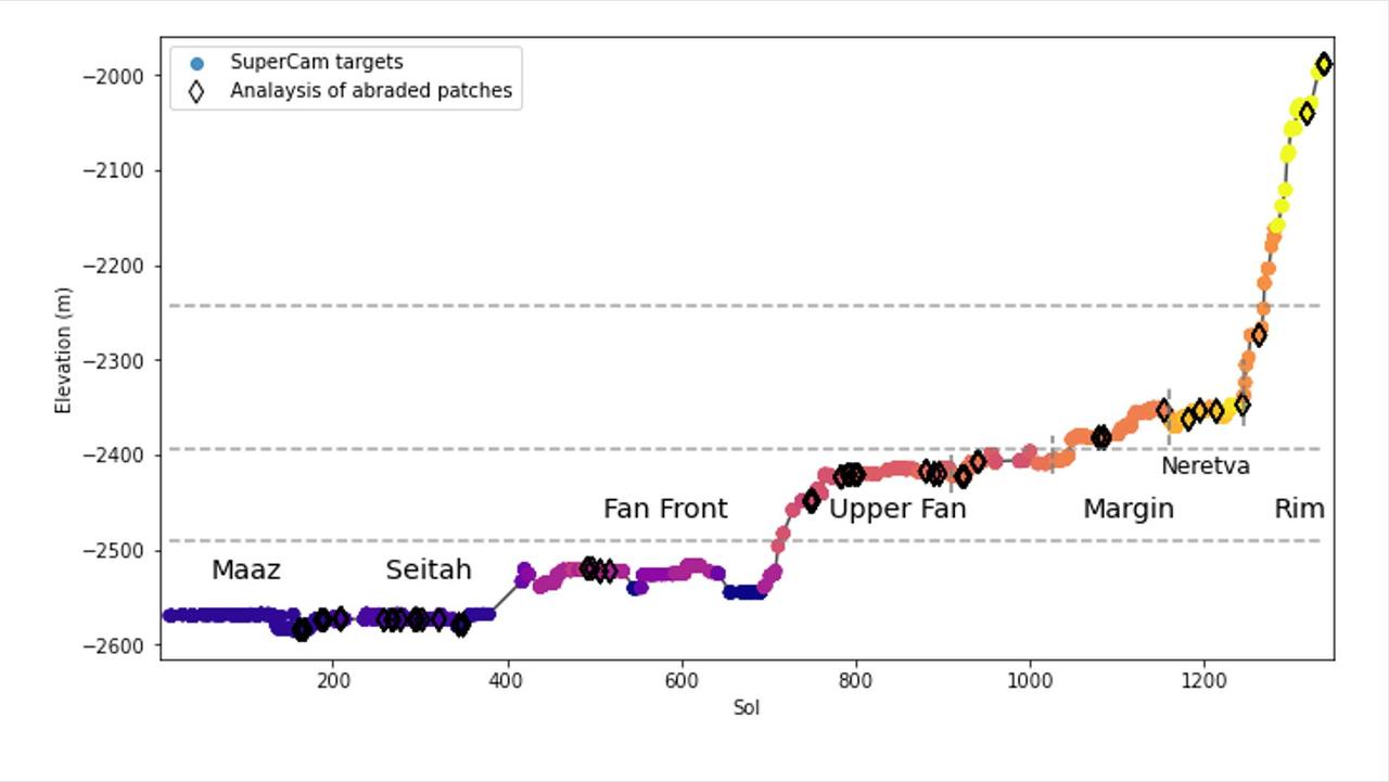
This graph shows the relative elevation of various sampling sites visited by NASA's Perseverance Mars rover. Colored dots along the line represent targets where data was collected by the rover's SuperCam laser instrument; the colors correspond to different regions within Jezero Crater, which are labeled. The black diamonds represent locations where the rover's abrasion tool was used to collect data on rock composition. The x-axis indicates the sol, or day, of the rover's mission, and the y-axis shows elevation in meters. Jezero Crater sits about 8,530 feet (2,600 meters) below reference level (the equivalent for "sea level" on Mars, which does not have any oceans), which is why the numbers appear to be decreasing as Perseverance is gaining elevation. The dotted horizontal lines represent estimated levels of ancient, now-dry lakes. Jezero Crater was filled by water for much of its history; this lake environment could have preserved signs of microbial life, if any formed here billions of years ago. At the far right of the graph, the line suddenly jumps, indicating a sharp elevation gain, showing how quickly the rover has ascended toward the crater rim. A key objective for Perseverance's mission on Mars is astrobiology, including the search for signs of ancient microbial life. The rover will characterize the planet's geology and past climate, pave the way for human exploration of the Red Planet, and be the first mission to collect and cache Martian rock and regolith (broken rock and dust). Subsequent NASA missions, in cooperation with ESA (European Space Agency), would send spacecraft to Mars to collect these sealed samples from the surface and return them to Earth for in-depth analysis. The Mars 2020 Perseverance mission is part of NASA's Moon to Mars exploration approach, which includes Artemis missions to the Moon that will help prepare for human exploration of the Red Planet. https://photojournal.jpl.nasa.gov/catalog/PIA26476
NASA's Perseverance Mars rover looks out at the expanse of Jezero Crater's river delta on April 11, 2022, the 406th Martian day, or sol, of the mission. This panorama is made up of 64 individual images from the rover's Mastcam-Z camera system and stitched together after the files were sent back from Mars. The color bands of the image have been processed to improve visual contrast and accentuate color differences. The sky would not actually look blue to a human explorer on the Red Planet. The delta formed billions of years ago from sediment that an ancient river carried to the mouth of the lake that once existed in the crater. Aeolian bedforms (sand dunes) can be seen running along the base of the delta. The hills visible on the distant horizon to the far left of the image – about 3.8 miles (6.2 kilometers) away from the rover – are actually part of the rim of Jezero Crater. The peak of the delta remnant to the right center of the image is about 920 feet (260 meters) away and the peak of the hill camera right is about 950 feet (280 meters) away. The portion of the delta farthest left in this image (visible directly below the crater wall) is the area where "Cape Nukshak" and "Hawksbill Gap" channels can be found. The rover is expected to ascend to the top of the delta via one of these two channels. A key objective for Perseverance's mission on Mars is astrobiology, including the search for signs of ancient microbial life. The rover will characterize the planet's geology and past climate, pave the way for human exploration of the Red Planet, and be the first mission to collect and cache Martian rock and regolith (broken rock and dust). Subsequent NASA missions, in cooperation with ESA (European Space Agency), would send spacecraft to Mars to collect these sealed samples from the surface and return them to Earth for in-depth analysis. The Mars 2020 Perseverance mission is part of NASA's Moon to Mars exploration approach, which includes Artemis missions to the Moon that will help prepare for human exploration of the Red Planet. https://photojournal.jpl.nasa.gov/catalog/PIA25212
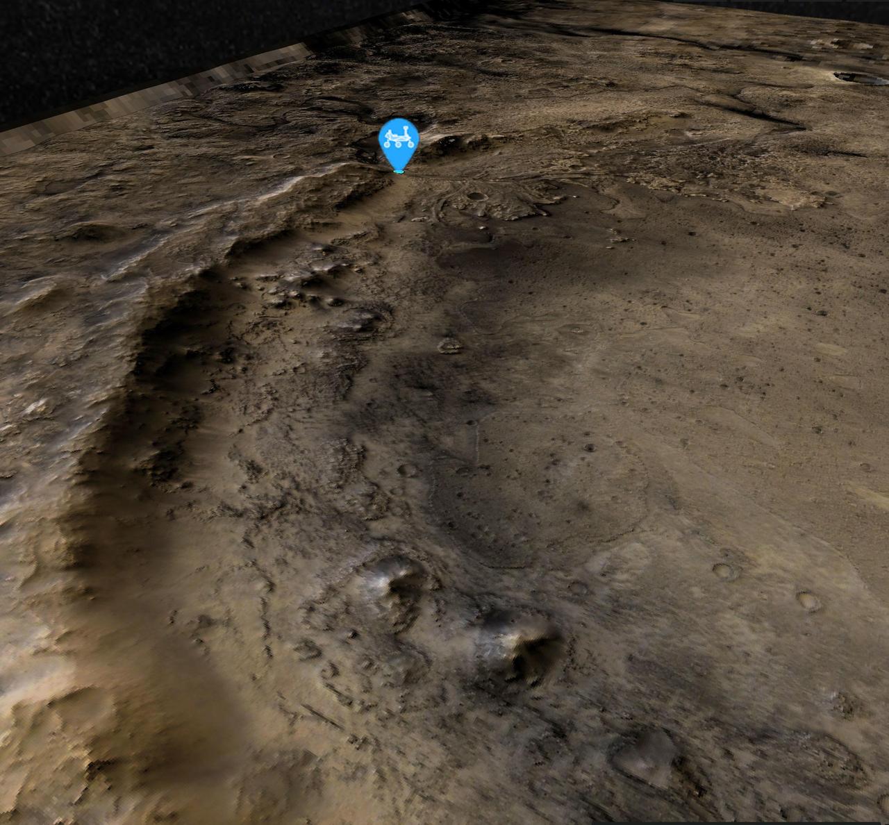
This view of the western edge of Mars' Jezero Crater shows the steep crater rim, which stands roughly 1,000 feet (300 meters) tall. The view looks northwest from the southern edge of the crater. A blue icon shows Perseverance's general location as of Aug. 14, 2024, the 1,238th Martian day, or sol, of the mission. The rover began its ascent of the crater rim on Aug. 27, 2024. Perseverance will encounter slopes of up to 23 degrees (rover drivers plan routes to avoid slopes that would tilt the rover more than 30 degrees) on its way to summit at a place nicknamed "Aurora Park." The high-resolution base map was created with images from the HiRISE (High-Resolution Imaging Science Experiment) camera on NASA's Mars Reconnaissance Orbiter, while the broader color base map is from the High-Resolution Stereo camera on ESA's (the European Space Agency's) Mars Express. Color processing has been applied to both maps to highlight surface features. https://photojournal.jpl.nasa.gov/catalog/PIA26402
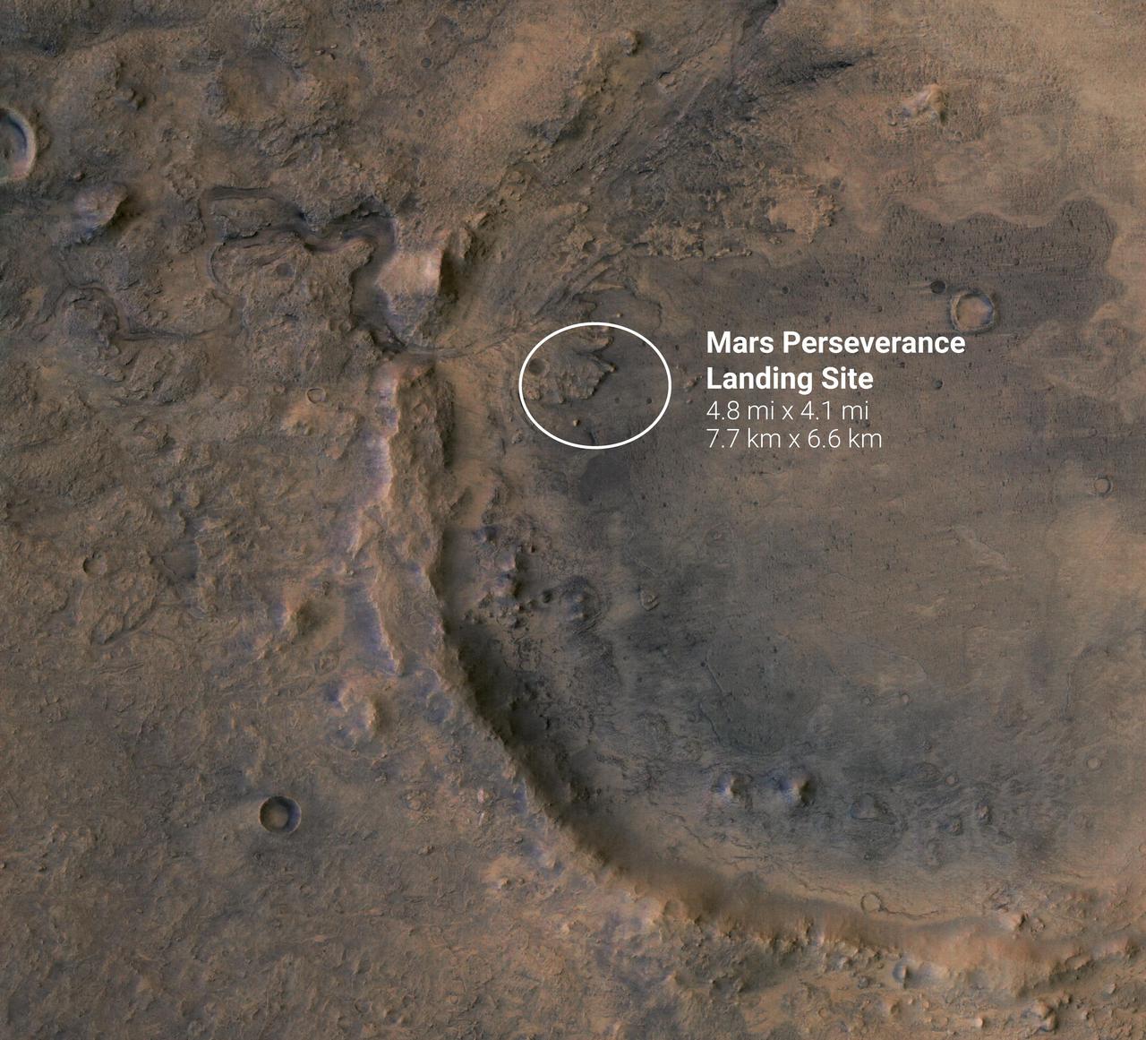
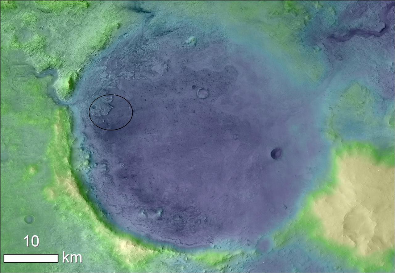
The white circle near the center of this image of Mars represents the location where NASA's Perseverance rover is expected to land on Feb. 18, 2021. The landing ellipse, measuring 4.8 miles by 4.1 miles (7.7 kilometers by 6.6 kilometers), places the rover at the site of an ancient river delta which could harbor signs of fossilized microbial life. The fan-like shape of the delta is visible in this image, as is the crater rim. The crater was once filled with a lake several hundred feet deep. Jezero Crater sits within the Isidis Planitia region of Mars, where an ancient asteroid or comet impact left behind a large basin some 750 miles (1200 kilometers) across. This event forever changed the rocks in and around the basin. A later, smaller impact created Jezero Crater within the Isidis impact basin. There is evidence of ancient river flow into Jezero, forming a lake that has long since been dry. Scientists believe that these events likely created environments friendly to life. https://photojournal.jpl.nasa.gov/catalog/PIA24350
This 60-second video pans across an enhanced-color composite image, or mosaic, of the delta at Jezero Crater on Mars. The delta formed billions of years ago from sediment that an ancient river carried to the mouth of the lake that once existed in the crater. Taken by the Mastcam-Z instrument aboard NASA's Perseverance rover, the video begins looking almost due west of the rover, and sweeps to the right until it faces almost due north. Fourteen images compose the mosaic that provides the base image for this video (included as an additional figure); they were acquired on Nov. 28, 2021 (the 275th sol, or Martian day, of Perseverance's mission) as the rover sat at the highest vantage point in the "South Séítah" geological unit, allowing a perspective that included boulders and other features atop the delta as well as farther west and northwest across its surface. The mountains in the background are the rim of Jezero Crater. The view also shows brown hills in the middle distance that are part of an ancient delta, where a river hit a lake in the crater. The rover has spent the last several months exploring the sandy and rocky terrain in the foreground. The color bands of the image have been processed to improve visual contrast and accentuate color differences. The sky would not actually look blue to a human explorer on the Red Planet. The Mastcam-Z investigation is led and operated by Arizona State University in Tempe, working in collaboration with Malin Space Science Systems in San Diego, California, on the design, fabrication, testing, and operation of the cameras, and in collaboration with the Neils Bohr Institute of the University of Copenhagen on the design, fabrication, and testing of the calibration targets. A key objective for Perseverance's mission on Mars is astrobiology, including the search for signs of ancient microbial life. The rover will characterize the planet's geology and past climate, pave the way for human exploration of the Red Planet, and be the first mission to collect and cache Martian rock and regolith (broken rock and dust). Subsequent NASA missions, in cooperation with ESA (European Space Agency), would send spacecraft to Mars to collect these sealed samples from the surface and return them to Earth for in-depth analysis. The Mars 2020 Perseverance mission is part of NASA's Moon to Mars exploration approach, which includes Artemis missions to the Moon that will help prepare for human exploration of the Red Planet. Movie available at https://photojournal.jpl.nasa.gov/catalog/PIA25022

NASA's Perseverance rover was able to use its new Terrain-Relative Navigation technology to avoid hazards and find a safe place to land in Jezero Crater on Mars. In this graphic, the blue areas are considered safe zones and red are considered more dangerous. Perseverance's landing spot is marked with a green dot. A version with an arrow makes the landing site easier to see. A key objective for Perseverance's mission on Mars is astrobiology, including the search for signs of ancient microbial life. The rover will characterize the planet's geology and past climate, pave the way for human exploration of the Red Planet, and be the first mission to collect and cache Martian rock and regolith (broken rock and dust). Subsequent NASA missions, in cooperation with ESA (European Space Agency), would send spacecraft to Mars to collect these sealed samples from the surface and return them to Earth for in-depth analysis. The Mars 2020 mission is part of a larger program that includes missions to the Moon as a way to prepare for human exploration of the Red Planet. https://photojournal.jpl.nasa.gov/catalog/PIA23970
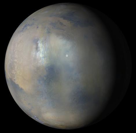
Multiple images from the Mars Color Imager (MARCI) aboard NASA's Mars Reconnaissance Orbiter (MRO) were used to generate this view of a regional dust storm obscuring Syrtis Major and Jezero Crater (white circle). The images were acquired on Jan. 9, 2022. MRO creates global maps of Mars but roll maneuvers for targeted observations produce gaps in the coverage, which appear as black gores in the maps. On some days there are data drops where partial or full orbits of coverage are missing. Green and purple observed in the south polar region indicate saturated pixels. https://photojournal.jpl.nasa.gov/catalog/PIA25068
This image shows with a green dot where NASA's Perseverance rover landed in Jezero Crater on Mars on Feb. 18, 2021. The base image was taken by the HiRISE camera aboard NASA's Mars Reconnaissance Orbiter. A key objective for Perseverance's mission on Mars is astrobiology, including the search for signs of ancient microbial life. The rover will characterize the planet's geology and past climate, pave the way for human exploration of the Red Planet, and be the first mission to collect and cache Martian rock and regolith (broken rock and dust). Subsequent NASA missions, in cooperation with ESA (European Space Agency), would send spacecraft to Mars to collect these sealed samples from the surface and return them to Earth for in-depth analysis. The Mars 2020 Perseverance mission is part of NASA's Moon to Mars exploration approach, which includes Artemis missions to the Moon that will help prepare for human exploration of the Red Planet. https://photojournal.jpl.nasa.gov/catalog/PIA24331

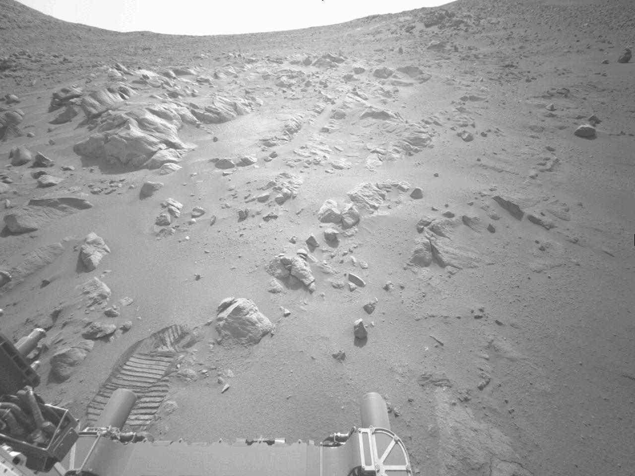
This image of a Martian vista in Jezero Crater, made from smaller individual images, was taken by NASA's Perseverance rover on July 3, 2021 (the 131th sol, or Martian day, of its mission). The rover's tracks from its autonomous drive that day are visible on the right. The images that compose the larger mosaic came from the rover's Navigation Cameras and were processed to enhance the contrast. Perseverance has been exploring the floor of Jezero since it landed on Feb. 18, 2021. A key objective for Perseverance's mission on Mars is astrobiology, including the search for signs of ancient microbial life. The rover will characterize the planet's geology and past climate, pave the way for human exploration of the Red Planet, and be the first mission to collect and cache Martian rock and regolith (broken rock and dust). The Mars 2020 Perseverance mission is part of NASA's Moon to Mars exploration approach, which includes Artemis missions to the Moon that will help prepare for human exploration of the Red Planet. Subsequent NASA missions, in cooperation with ESA (European Space Agency), would send spacecraft to Mars to collect these sealed samples from the surface and return them to Earth for in-depth analysis. https://photojournal.jpl.nasa.gov/catalog/PIA24744
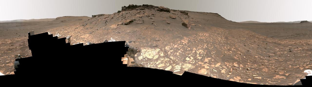
This enhanced-color, high-resolution mosaic showing Mars' Jezero Crater was taken by the Mastcam-Z instrument on NASA's Perseverance as the rover climbed the crater's western wall. Many of the landmarks visited by the rover during its 3½-year exploration of Jezero can be seen, and the vehicle's tracks are also visible. The 44 frames used to generate the mosaic were acquired on Sept. 27, 2024, the 1,282nd Martian day, or sol, of Perseverance's mission. The rover was near a location the Perseverance science team calls "Faraway Rock," about halfway up the climb. Arizona State University leads the operations of the Mastcam-Z instrument, working in collaboration with Malin Space Science Systems in San Diego, on the design, fabrication, testing, and operation of the cameras, and in collaboration with the Niels Bohr Institute of the University of Copenhagen on the design, fabrication, and testing of the calibration targets. A key objective for Perseverance's mission on Mars is astrobiology, including the search for signs of ancient microbial life. The rover will characterize the planet's geology and past climate, pave the way for human exploration of the Red Planet, and be the first mission to collect and cache Martian rock and regolith (broken rock and dust). Subsequent NASA missions, in cooperation with ESA (European Space Agency), would send spacecraft to Mars to collect these sealed samples from the surface and return them to Earth for in-depth analysis. The Mars 2020 Perseverance mission is part of NASA's Moon to Mars exploration approach, which includes Artemis missions to the Moon that will help prepare for human exploration of the Red Planet. https://photojournal.jpl.nasa.gov/catalog/PIA26378

This mosaic featuring several of the escarpments, or scarps – long, steep slopes – of Jezero Crater's river delta was taken by the Mastcam-Z instrument aboard NASA's Perseverance rover on Apr. 17, 2021. The delta formed billions of years ago from sediment that an ancient river carried to the mouth of the lake that once existed in the crater. The images that stitched together to create the mosaic were taken from a distance of about 1.2 miles (2.2 kilometers). An annotated version of this image (Figure 1) indicates the location of four prominent scarps in the delta. The Mastcam-Z investigation is led and operated by Arizona State University in Tempe, working in collaboration with Malin Space Science Systems in San Diego, California, on the design, fabrication, testing, and operation of the cameras, and in collaboration with the Neils Bohr Institute of the University of Copenhagen on the design, fabrication, and testing of the calibration targets. A key objective for Perseverance's mission on Mars is astrobiology, including the search for signs of ancient microbial life. The rover will characterize the planet's geology and past climate, pave the way for human exploration of the Red Planet, and be the first mission to collect and cache Martian rock and regolith (broken rock and dust). Subsequent NASA missions, in cooperation with ESA (European Space Agency), would send spacecraft to Mars to collect these sealed samples from the surface and return them to Earth for in-depth analysis. The Mars 2020 Perseverance mission is part of NASA's Moon to Mars exploration approach, which includes Artemis missions to the Moon that will help prepare for human exploration of the Red Planet. https://photojournal.jpl.nasa.gov/catalog/PIA24815
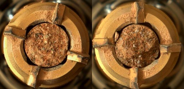
In this video, the robotic arm on NASA’s Perseverance Mars rover uses its percussive drill on a rocky outcrop near the rim of Jezero Crater that the science team calls “Kenmore” on June 10, 2025, the 1,531st Martian day, or sol, of the mission. Before drilling, the team abraded the rock to determine it was worthy of drilling. The eight images that make up this GIF were taken approximately one minute apart by one of the rover's front hazard-avoidance cameras. Animation available at https://photojournal.jpl.nasa.gov/catalog/PIA26575
NASA's Perseverance Mars rover drove first backward then forward as it negotiated some slippery terrain found along a route up the rim of Jezero Crater that the science team calls "Summerland Trail." The 31 images used to create this video were acquired by one of the rover's navigation cameras on Oct. 15, 2024, the 1,299th Martian day, or sol, of the mission. A key objective for Perseverance's mission on Mars is astrobiology, including the search for signs of ancient microbial life. The rover will characterize the planet's geology and past climate, pave the way for human exploration of the Red Planet, and be the first mission to collect and cache Martian rock and regolith (broken rock and dust). Subsequent NASA missions, in cooperation with ESA (European Space Agency), would send spacecraft to Mars to collect these sealed samples from the surface and return them to Earth for in-depth analysis. The Mars 2020 Perseverance mission is part of NASA's Moon to Mars exploration approach, which includes Artemis missions to the Moon that will help prepare for human exploration of the Red Planet. Video available at https://photojournal.jpl.nasa.gov/catalog/PIA26377
The long, steep slope known as an escarpment, or scarp, along the delta in Mars' Jezero Crater that the science team of NASA's Perseverance rover mission refers to as "Scarp a" is seen in this image captured by the rover's Mastcam-Z instrument on Apr. 17, 2021. The Mastcam-Z investigation is led and operated by Arizona State University in Tempe, working in collaboration with Malin Space Science Systems in San Diego, California, on the design, fabrication, testing, and operation of the cameras, and in collaboration with the Neils Bohr Institute of the University of Copenhagen on the design, fabrication, and testing of the calibration targets. A key objective for Perseverance's mission on Mars is astrobiology, including the search for signs of ancient microbial life. The rover will characterize the planet's geology and past climate, pave the way for human exploration of the Red Planet, and be the first mission to collect and cache Martian rock and regolith (broken rock and dust). Subsequent NASA missions, in cooperation with ESA (European Space Agency), would send spacecraft to Mars to collect these sealed samples from the surface and return them to Earth for in-depth analysis. The Mars 2020 Perseverance mission is part of NASA's Moon to Mars exploration approach, which includes Artemis missions to the Moon that will help prepare for human exploration of the Red Planet. https://photojournal.jpl.nasa.gov/catalog/PIA24813
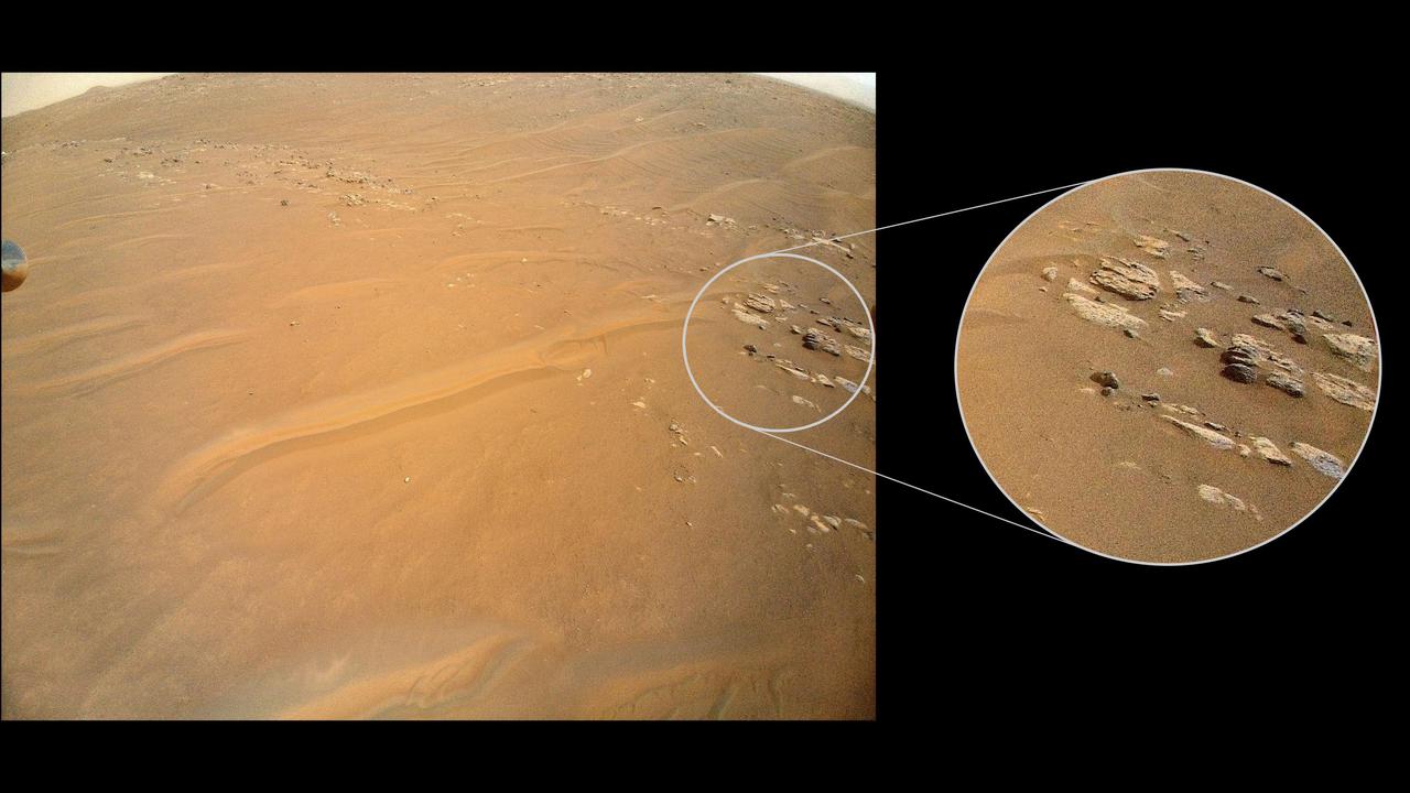
This image of "Yori Pass" was taken by one of the Hazard-Avoidance Cameras (Hazcams) on NASA's Perseverance Mars rover on Nov. 5, 2022, the 609th Martian day, or sol, of the mission. The feature, at the base of Jezero Crater, is sandstone, which is composed of fine grains that have been carried from elsewhere by water before settling and forming stone. The rover will take a rock-core sample here. A key objective for Perseverance's mission on Mars is astrobiology, including the search for signs of ancient microbial life. The rover will characterize the planet's geology and past climate, pave the way for human exploration of the Red Planet, and be the first mission to collect and cache Martian rock and regolith (broken rock and dust). Subsequent NASA missions, in cooperation with ESA (European Space Agency), would send spacecraft to Mars to collect these sealed samples from the surface and return them to Earth for in-depth analysis. The Mars 2020 Perseverance mission is part of NASA's Moon to Mars exploration approach, which includes Artemis missions to the Moon that will help prepare for human exploration of the Red Planet. https://photojournal.jpl.nasa.gov/catalog/PIA25339
This animated artist's concept depicts a scene of water breaking through the rim of Mars' Jezero Crater, which NASA's Perseverance rover is now exploring. Water entered the crater billions of years ago, depositing sediments that built up into a delta. Since the spacecraft's landing in February 2021, Perseverance's exploration of the crater floor and the delta have led to scientists developing a detailed timeline for the crater's formation. They now know there were three major periods after water began flooding through the crater rim. First, those waters brought fine-grained sand and mud (seen by Perseverance at "Hogwallow Flats") that is known for preserving fossilized life in comparable environments on Earth. Second, the crater's lake grew as wide as 22 miles (35 kilometers) in diameter and as deep as 100 feet (30 meters) – deep enough to lay down several sedimentary layers (like those seen at "Pinestand"). Finally, high-energy rivers brought in boulders that were rounded as they tumbled through water, as seen at "Castell Henllys." A key objective for Perseverance's mission on Mars is astrobiology, including the search for signs of ancient microbial life. The rover will characterize the planet's geology and past climate, pave the way for human exploration of the Red Planet, and be the first mission to collect and cache Martian rock and regolith (broken rock and dust). Subsequent NASA missions, in cooperation with ESA (European Space Agency), would send spacecraft to Mars to collect these sealed samples from the surface and return them to Earth for in-depth analysis. The Mars 2020 Perseverance mission is part of NASA's Moon to Mars exploration approach, which includes Artemis missions to the Moon that will help prepare for human exploration of the Red Planet. Animation available at https://photojournal.jpl.nasa.gov/catalog/PIA26207

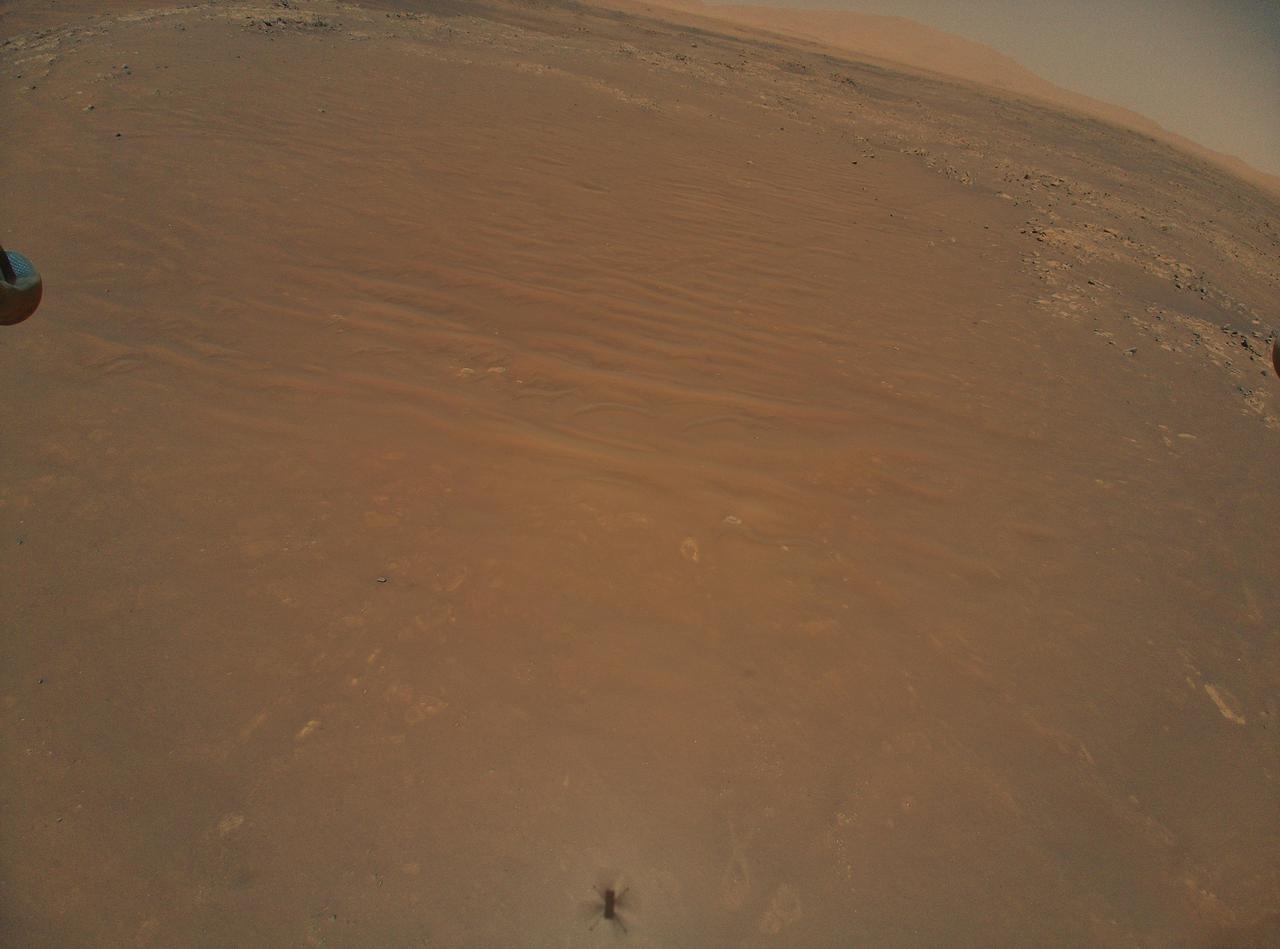
NASA's Perseverance Mars rover used one of its navigation cameras to capture these dust devils swirling across Jezero Crater on July 20, 2021, the 148th Martian day, or sol, of the mission. This GIF has been enhanced in order to show maximal detail, with some color distortion. The three images that have been included were taken about 15 seconds apart. A key objective for Perseverance's mission on Mars is astrobiology, including the search for signs of ancient microbial life. The rover will characterize the planet's geology and past climate, pave the way for human exploration of the Red Planet, and be the first mission to collect and cache Martian rock and regolith (broken rock and dust). Subsequent NASA missions, in cooperation with ESA (European Space Agency), would send spacecraft to Mars to collect these sealed samples from the surface and return them to Earth for in-depth analysis. The Mars 2020 Perseverance mission is part of NASA's Moon to Mars exploration approach, which includes Artemis missions to the Moon that will help prepare for human exploration of the Red Planet. Anaimation available at https://photojournal.jpl.nasa.gov/catalog/PIA25290
Intriguing Martian rocks surround NASA's Perseverance rover in this panorama showing an ancient river delta, made from images captured by the Mastcam-Z camera system. This 2.5-billion-pixel mosaic, which combines 1,118 individual frames, is the most detailed landscape panorama ever returned from Mars. The delta in Mars' Jezero Crater is an area where scientists surmise that, billions of years ago, a river once flowed into a lake and deposited rocks and sediments in a fan shape. Deltas are believed to be the best places on Mars to search for potential signs of ancient microbial life. Arrival at the Jezero delta has been a primary goal of the Perseverance mission since the rover landed in the crater in February 2021. The panorama shows sedimentary rocks of great interest to scientists. The Perseverance rover has abraded the surface of several rocks in this area and acquired compositional information. It also has collected rock samples that the Mars Sample Return campaign could bring back to Earth in the future, enabling detailed laboratory studies as part of a search for signs of ancient life. In this enhanced-color view, the color bands of the image have been processed to improve visual contrast and accentuate color differences. Figure A shows the same panorama using a natural-color view. A guided tour of the panorama is available at https://images.nasa.gov/details-JPL-20220906-Perseverance_Explores_Jezero_Crater_Delta_UHD. These images were taken in 2022 on June 12, 13, 16, 17, and 20 (the 466th, 467th, 470th, 471st, and 474th Martian days, or sols, of Perseverance's mission). A key objective for Perseverance's mission on Mars is astrobiology, including the search for signs of ancient microbial life. The rover will characterize the planet's geology and past climate, pave the way for human exploration of the Red Planet, and be the first mission to collect and cache Martian rock and regolith (broken rock and dust). Subsequent NASA missions, in cooperation with ESA (European Space Agency), would send spacecraft to Mars to collect these sealed samples from the surface and return them to Earth for in-depth analysis. The Mars 2020 Perseverance mission is part of NASA's Moon to Mars exploration approach, which includes Artemis missions to the Moon that will help prepare for human exploration of the Red Planet. https://photojournal.jpl.nasa.gov/catalog/PIA24921

From its landing site, "Octavia E. Butler Landing," NASA's Perseverance rover can see a remnant of a fan-shaped deposit of sediments known as a delta with its Mastcam-Z instrument. Scientists believe this delta is what remains of the confluence between an ancient river and a lake at Mars' Jezero Crater. The delta remnant is the raised area of dark brown rock in the middle ground this image acquired on Feb. 22, 2021. An annotated version of the image shows a scale bar for 30 feet (10 meters). The delta remnant is about 1.4 miles (2.3 kilometers) to the west of the Perseverance landing site. The visible portion of the remnant is about 660 feet (200 meters) across. In the foreground is a boulder about 6 feet (2 meters) across that is about 425 feet (130 meters) from the rover. The image colors portray an estimate of the natural color of each scene, or approximately what the scene would look like if we viewed it with human eyes. A key objective for Perseverance's mission on Mars is astrobiology, including the search for signs of ancient microbial life. The rover will characterize the planet's geology and past climate, pave the way for human exploration of the Red Planet, and be the first mission to collect and cache Martian rock and regolith (broken rock and dust). Subsequent NASA missions, in cooperation with ESA (European Space Agency), would send spacecraft to Mars to collect these sealed samples from the surface and return them to Earth for in-depth analysis. The Mars 2020 Perseverance mission is part of NASA's Moon to Mars exploration approach, which includes Artemis missions to the Moon that will help prepare for human exploration of the Red Planet. https://photojournal.jpl.nasa.gov/catalog/PIA24485

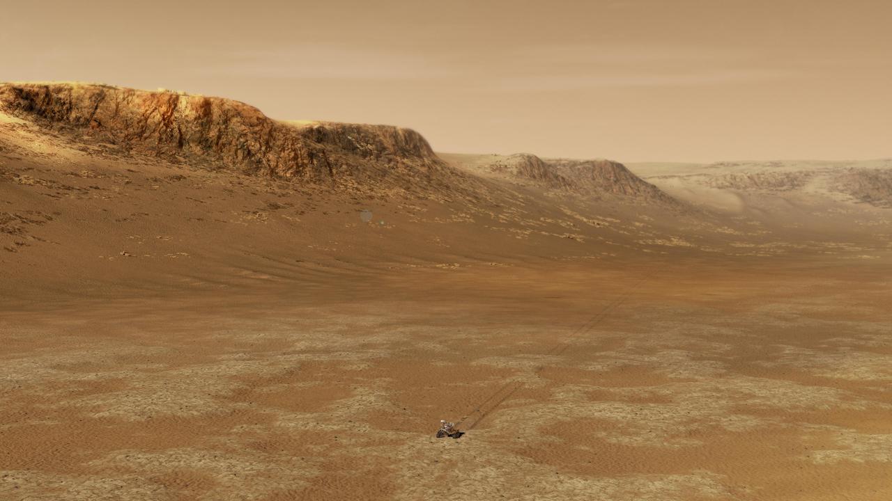
This artist's concept depicts an aerial view of what the Jezero Crater area of Mars may have looked like billions of years ago. https://photojournal.jpl.nasa.gov/catalog/PIA22907
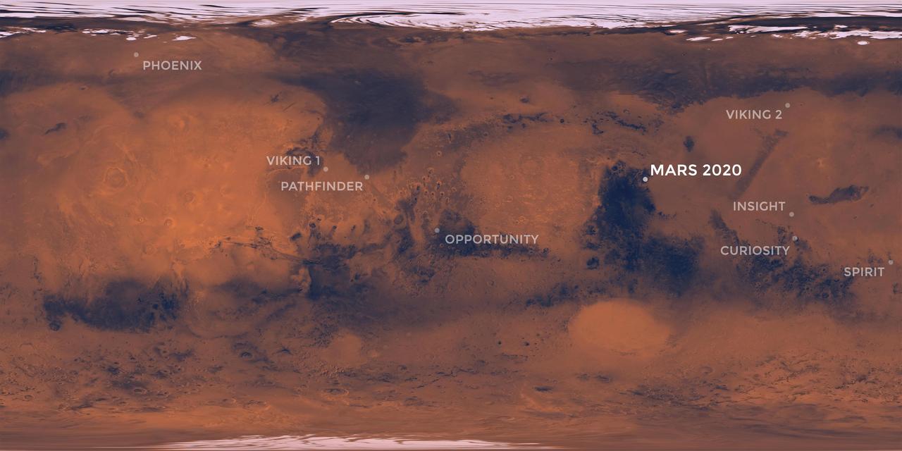
This map of the Red Planet shows Jezero Crater, where NASA's Mars 2020 rover is scheduled to land in February 2021. Also included are the locations where all of NASA's other successful Mars missions touched down. https://photojournal.jpl.nasa.gov/catalog/PIA23518
NASA's Ingenuity Mars Helicopter recently surveyed a ridgeline near the ancient river delta in Mars' Jezero Crater at request of the Perseverance rover's science team. On the left is the full image Ingenuity acquired of the ridgeline on April 23, 2022, during its 27th flight. The science team calls the line of rocky outcrops running from the upper left to middle right of the main image "Fortun Ridge." Enlarged at right is a close-up of one of the ridgeline's rocky outcrops. This portion of Jezero Crater is of interest to the science team because of the clear exposure of the rocky outcrops that define the boundary between two abutting crater floor geologic units, "Séítah" and "Máaz." The geology of both units is thought to be of igneous (volcanic) origin. https://photojournal.jpl.nasa.gov/catalog/PIA25220
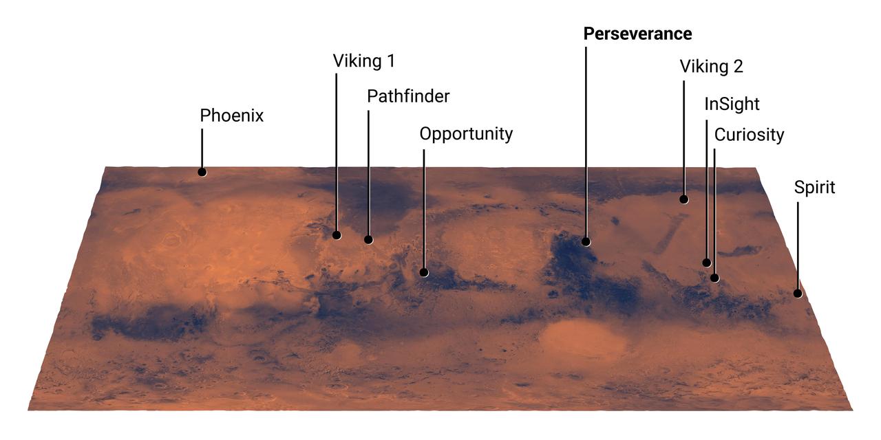
This map of Mars shows the landing site for NASA's Perseverance rover in relation to those of previous successful Mars missions. The newest addition to the group, Perseverance is set to land in Jezero Crater on Feb. 18, 2021. https://photojournal.jpl.nasa.gov/catalog/PIA24320
This close-up view of a rock target named "Dourbes" was provided by the WATSON (Wide Angle Topographic Sensor for Operations and eNgineering) camera on the end of the robotic arm aboard NASA's Perseverance Mars rover. WATSON took a series of eight fully-shadowed images on Nov. 5, 2021, the 253rd Martian day, or sol, of the mission, and the images were subsequently merged to create this view. Before drilling rocks, the rover abrades the rock surface using a tool on its robotic arm to clear away dust and weathering rinds, allowing other instruments to study the rocks in detail. The abraded patch is 2 inches (5 centimeters) in diameter. Perseverance subsequently acquired two rock core samples from this outcrop, called "Brac," which forms part of the "South Séítah" geologic unit of Jezero Crater. The WATSON image shows that the abrasion patch is dominated by discrete areas of light-toned material, with subordinate brown, dark-toned interstitial areas. The chemistry and mineralogy of the abrasion patch was analysed by a series of co-registered observations using the SuperCam, Mastcam-Z, PIXL (Planetary Instrument for X-ray Lithochemistry), and SHERLOC (Scanning Habitable Environments with Raman & Luminescence for Organics & Chemicals) instruments. A subsystem of an instrument called SHERLOC (Scanning Habitable Environments with Raman & Luminescence for Organics & Chemicals), WATSON can document the structure and texture within a drilled or abraded target, and its data can be used to derive depth measurements. WATSON was built by Malin Space Science Systems (MSSS) in San Diego and is operated jointly by MSSS and JPL. A key objective for Perseverance's mission on Mars is astrobiology, including the search for signs of ancient microbial life. The rover will characterize the planet's geology and past climate, pave the way for human exploration of the Red Planet, and be the first mission to collect and cache Martian rock and regolith (broken rock and dust). Subsequent NASA missions, in cooperation with ESA (European Space Agency), would send spacecraft to Mars to collect these sealed samples from the surface and return them to Earth for in-depth analysis. The Mars 2020 Perseverance mission is part of NASA's Moon to Mars exploration approach, which includes Artemis missions to the Moon that will help prepare for human exploration of the Red Planet. https://photojournal.jpl.nasa.gov/catalog/PIA24940

This wide view of Mars' Jezero Crater was taken by NASA's Perseverance rover on July 15, 2021 (the 143rd sol, or Martian day, of its mission). The rover has driven nearly a mile (1.5 kilometers) south of its landing site, "Octavia E. Butler Landing," into a region the team has nicknamed the "Crater Floor Fractured Rough" unit. The stones that appear light-colored and flat in this image are informally referred to as the "paver rocks" and will be the first type from which Perseverance will collect a sample for planned return to Earth by subsequent missions. Small hills to the south of the rover and the sloping inner walls of the Jezero Crater rim fill the distant background of this view. Five images from the rover's Mastcam-Z instrument were calibrated and combined to make this mosaic. Perseverance has been exploring the floor of Jezero since landing on Feb. 18, 2021. The Mastcam-Z investigation is led and operated by Arizona State University in Tempe, working in collaboration with Malin Space Science Systems in San Diego, California, on the design, fabrication, testing, and operation of the cameras, and in collaboration with the Neils Bohr Institute of the University of Copenhagen on the design, fabrication, and testing of the calibration targets. A key objective for Perseverance's mission on Mars is astrobiology, including the search for signs of ancient microbial life. The rover will characterize the planet's geology and past climate, pave the way for human exploration of the Red Planet, and be the first mission to collect and cache Martian rock and regolith. The Mars 2020 Perseverance mission is part of NASA's Moon to Mars exploration approach, which includes Artemis missions to the Moon that will help prepare for human exploration of the Red Planet. Subsequent NASA missions, in cooperation with ESA (European Space Agency), would send spacecraft to Mars to collect these sealed samples from the surface and return them to Earth for in-depth analysis. https://photojournal.jpl.nasa.gov/catalog/PIA24745
This color-enhanced image of the "Castell Henllys" region in Jezero Crater was taken by NASA's Ingenuity Mars Helicopter during the rotorcraft's 48th flight on March 21, 2023, the 741st Martian day, or sol, of the Perseverance rover's mission. At the time the image was taken, the helicopter was at an altitude of about 40 feet (12 meters). This image and others taken during the flight provided advanced reconnaissance to Perseverance scientists and planners roughly two weeks before the rover reached this area. https://photojournal.jpl.nasa.gov/catalog/PIA25890

Members of the Mars 2020 Perseverance rover mission pose at NASA's Jet Propulsion Laboratory, which manages the mission, on July 17, 2019. https://photojournal.jpl.nasa.gov/catalog/PIA23923
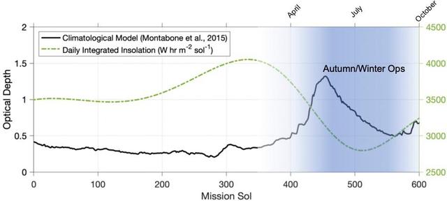
This graphic depicts the environmental conditions at Jezero Crater from the day NASA's Perseverance Mars rover landed there – on Feb. 18, 2021, the first Martian day, or sol, of the mission – through Sol 600. The black line indicates a climatological model of atmospheric opaqueness (a measurement known as "tau") over a Martian year. The expected daily insolation, or the amount of Sun's rays reaching the solar panel, is illustrated by the green dotted line. While a year on Earth lasts 365 days, on Mars a year lasts 668 sols. https://photojournal.jpl.nasa.gov/catalog/PIA25322
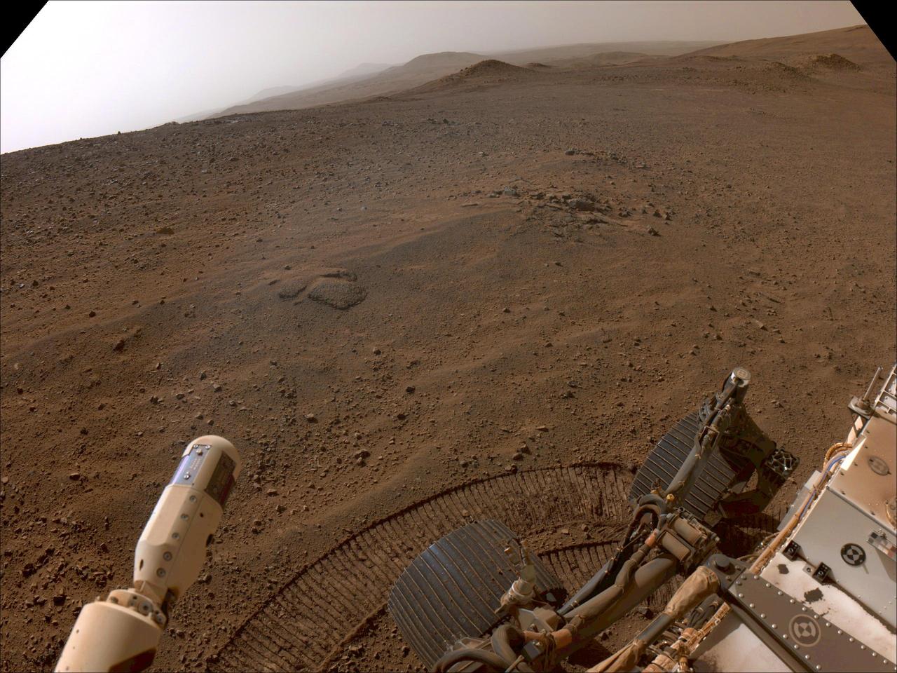
NASA's Perseverance Mars rover used its navigation cameras, or navcams, to capture this scene while driving up to Jezero Crater's rim on Nov. 11, 2024, the 1,326th Martian day, or sol, of the mission. The sandy terrain seen here, along with a 10-degree average slope, meant it was a slippery drive. Rover tracks trail off behind Perseverance in this image. Far in the distance is the floor of Jezero Crater. A key objective for Perseverance's mission on Mars is astrobiology, including the search for signs of ancient microbial life. The rover will characterize the planet's geology and past climate, pave the way for human exploration of the Red Planet, and be the first mission to collect and cache Martian rock and regolith (broken rock and dust). Subsequent NASA missions, in cooperation with ESA (European Space Agency), would send spacecraft to Mars to collect these sealed samples from the surface and return them to Earth for in-depth analysis. The Mars 2020 Perseverance mission is part of NASA's Moon to Mars exploration approach, which includes Artemis missions to the Moon that will help prepare for human exploration of the Red Planet. https://photojournal.jpl.nasa.gov/catalog/PIA26479
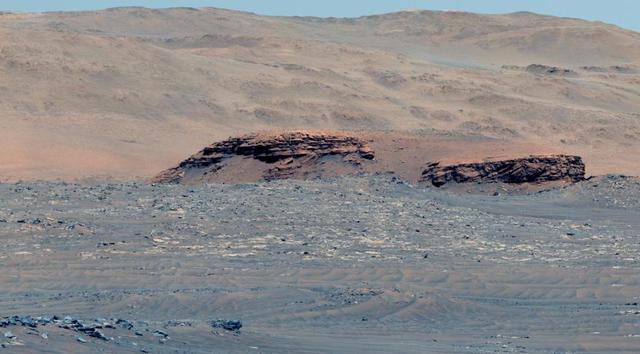
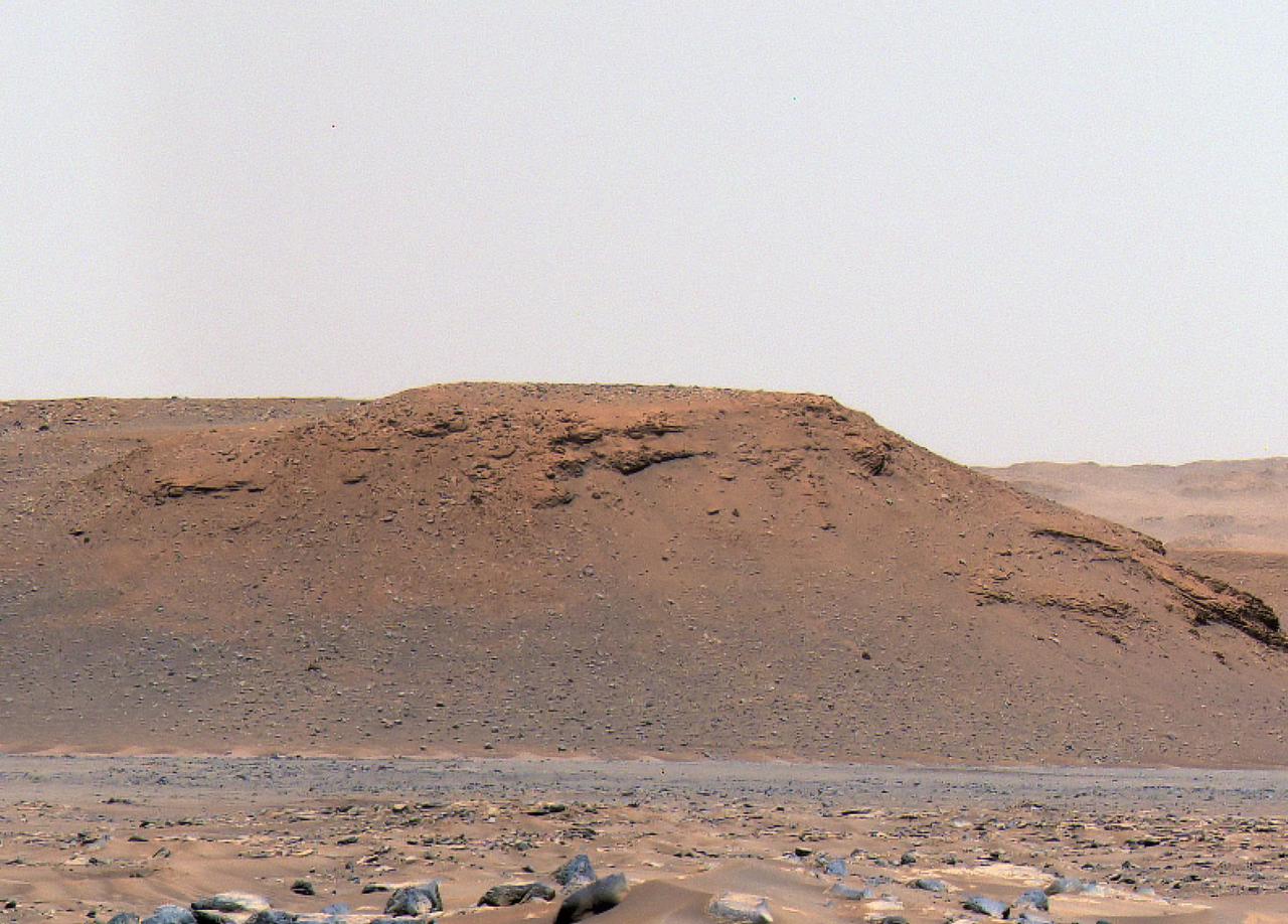
This image of the floor of Jezero Crater was taken by one of the Navcam imagers aboard NASA's Perseverance Mars rover on Feb. 5, 2023, the 698th Martian day, or sol, of the mission. The rover's tracks can be seen disappearing into the distance. The flat-topped hill that the science team refers to as "Kodiak," a remnant of Jezero Crater's river delta, is in the upper right of image, about 0.6 miles (1 kilometer) away. A key objective for Perseverance's mission on Mars is astrobiology, including the search for signs of ancient microbial life. The rover will characterize the planet's geology and past climate, pave the way for human exploration of the Red Planet, and be the first mission to collect and cache Martian rock and regolith (broken rock and dust). Subsequent NASA missions, in cooperation with ESA (European Space Agency), would send spacecraft to Mars to collect these sealed samples from the surface and return them to Earth for in-depth analysis. The Mars 2020 Perseverance mission is part of NASA's Moon to Mars exploration approach, which includes Artemis missions to the Moon that will help prepare for human exploration of the Red Planet. https://photojournal.jpl.nasa.gov/catalog/PIA25684
This annotated mosaic depicts a possible route the Mars 2020 Perseverance rover could take across Jezero Crater as it investigates several ancient environments that may have once been habitable. The route begins at the cliffs defining the base of a delta produced by a river as it flowed into a lake that once filled the crater. The path then traverses up and across the delta toward possible ancient shoreline deposits, and then climbs the 2,000-foot-high (610-meter-high) crater rim to explore the surrounding plains. About half of this traverse could be completed in Perseverance's prime mission (one Mars year, or two Earth years). For reference, the prominent crater near the center of the image is about 0.6 miles (1 kilometer) across. This mosaic is composed of multiple precisely aligned images from the Context Camera on the Mars Reconnaissance Orbiter and has a resolution of 20 meet (6 meters) per pixel. https://photojournal.jpl.nasa.gov/catalog/PIA24379
This image shows the "South Séítah" region of Jezero Crater, captured by NASA's Ingenuity Mars Helicopter during its 11th flight on August 4, 2021. At the bottom center of the image is Ingenuity's shadow. Above it, toward the top of the frame – just beyond the dune field and right of center – is the Perseverance rover (the bright white dot). https://photojournal.jpl.nasa.gov/catalog/PIA24793

On Sept. 23, 2019, Eric Nelson, the U.S. Ambassador to Bosnia and Herzegovina, presented a framed letter to Snezana Ružičić, mayor of the Balkan municipality of Jezero. The letter, from NASA's director of Mars Exploration, James Watzin, honored the connection between the small Balkan town and Jezero Crater the landing site of NASA's upcoming Mars 2020 mission. In this picture, Ružičić snaps a selfie of the ambassador with local school children. https://photojournal.jpl.nasa.gov/catalog/PIA23463

Eric Nelson, the U.S. Ambassador to Bosnia and Herzegovina, presents a framed letter to Snezana Ružičić, mayor of the Balkan municipality of Jezero. The letter, from NASA's director of Mars Exploration, James Watzin, honored the connection between the small Balkan town and Jezero Crater the landing site of NASA's upcoming Mars 2020 mission. https://photojournal.jpl.nasa.gov/catalog/PIA23464

A dust devil whirled by in the distance as one of the cameras on NASA's Perseverance captured the Mars rover coring a sample near the rim of Jezero Crater on April 29, 2025, the 1,490th Martian day, or sol, of the mission. The 12 images that make up this animation were taken approximately one minute apart by the rover's front right hazard-avoidance camera. The dust devil is in the upper right of the frame. The Mars 2020 Perseverance mission is part of NASA's Moon to Mars exploration approach, which includes Artemis missions to the Moon that will help prepare for human exploration of the Red Planet. Animation available at https://photojournal.jpl.nasa.gov/catalog/PIA26572
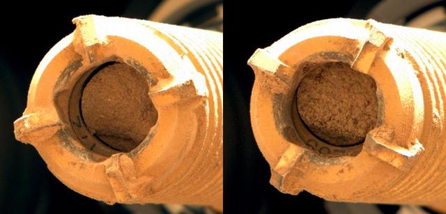
This pair of images shows two cylinders of rock the size of classroom chalk inside the drill of NASA's Perseverance rover from an outcrop called "Skinner Ridge" in Mars' Jezero Crater. The image of the rock core on the left, called "Swift Run," was taken by Perseverance's Mastcam-Z instrument on July 6, 2022, the 490th Martian day, or sol, of the mission. The image on the right, of the rock core called "Skyland," was taken on July 11, 2022, the 495th sol of the mission. Each core is about 0.5 inches, or 13 millimeters, in diameter and 2.4 inches, or 60 millimeters, long. They were taken from an ancient river delta in Jezero Crater, a fan-shaped area where, billions of years ago, a river once flowed into a lake and deposited rocks and sediment. Scientists believe these rock samples contain materials transported by water from potentially hundreds of miles outside of Jezero Crater. These rock cores have been sealed in ultra-clean sample tubes and stored in Perseverance's Sampling and Caching System as part of the mission's search for signs of ancient microbial life. The verification of ancient life on Mars carries an enormous burden of proof. A key objective for Perseverance's mission on Mars is astrobiology, including the search for signs of ancient microbial life. The rover will characterize the planet's geology and past climate, pave the way for human exploration of the Red Planet, and be the first mission to collect and cache Martian rock and regolith (broken rock and dust). Subsequent NASA missions, in cooperation with ESA (European Space Agency), would send spacecraft to Mars to collect these sealed samples from the surface and return them to Earth for in-depth analysis. The Mars 2020 Perseverance mission is part of NASA's Moon to Mars exploration approach, which includes Artemis missions to the Moon that will help prepare for human exploration of the Red Planet. https://photojournal.jpl.nasa.gov/catalog/PIA24927
This 3D view of an area the Mars Perseverance rover team calls "Raised Ridges" was created from data collected by NASA's Ingenuity Mars Helicopter during its 10th flight at Mars on July 24, 2021. The stereo images of the geologic feature were taken at the request of the Mars Perseverance rover science team, which was considering visiting the ridges during the first science campaign. On Earth, similar fractures in desert environments might be a clue to past liquid water activity and thus past habitability. The 3D view (or anaglyph) is best viewed with red-blue glasses. It was created by combining data from two images taken meters apart by the RTE camera aboard Ingenuity. At the time the two images were taken, Ingenuity was at an altitude of 40 feet (12 meters). https://photojournal.jpl.nasa.gov/catalog/PIA24688
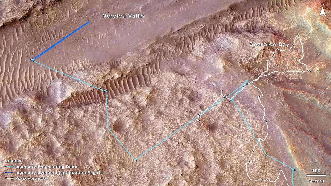
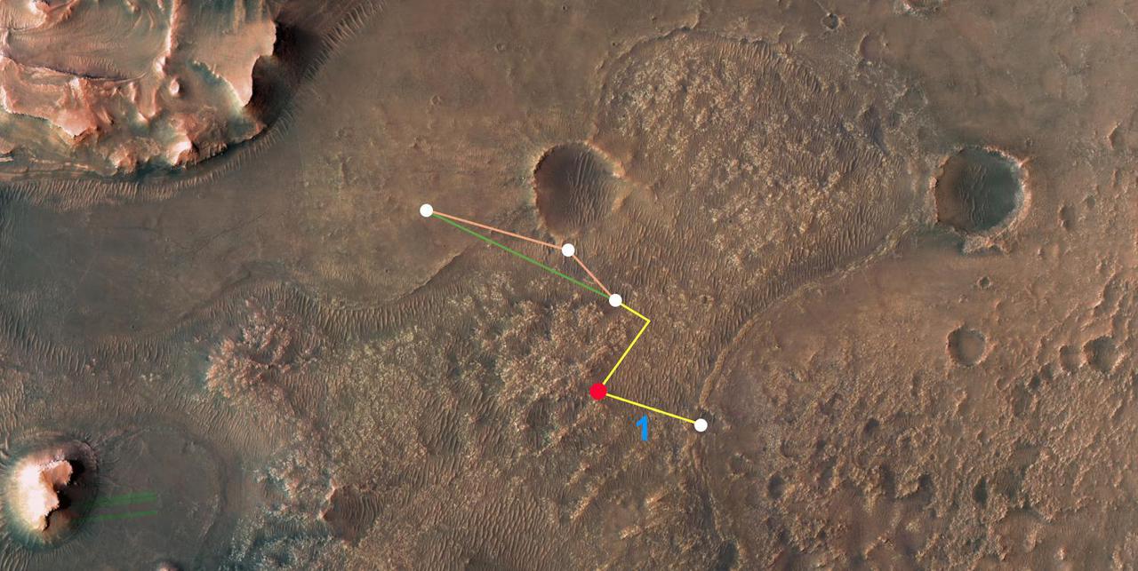
This map shows the locations of NASA's Perseverance rover (white star) and Ingenuity Mars Helicopter (cyan star) on Dec. 19, 2023, the 1,007th Martian day, or sol, of the rover's mission at Mars. During that sol, the rover conducted science operations in an area the team calls "Gnaraloo Bay," while Ingenuity conducted flights 68 and 69 in "Neretva Vallis," a lower-elevation, flatter area (top left). The dots along the white line indicate the stops made by the rover beginning with Sept. 28, 2023, or Sol 927 (lower right). Ingenuity airfields are indicated by dots along the cyan line, starting with Sept. 11, 2023, or Sol 910 (also lower right). Ingenuity flights 68 and 69 consisted of a system identification, or "Sys-ID," test campaign. Sys-ID is a data-driven method for understanding the complex behavior of a system by studying how specific inputs impact the motion of the vehicle. https://photojournal.jpl.nasa.gov/catalog/PIA26311
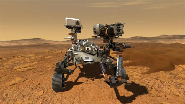
This illustration depicts NASA's Perseverance rover operating on the surface of Mars. Perseverance will land at the Red Planet's Jezero Crater a little after 3:40 p.m. EST (12:40 p.m. PST) on Feb. 18, 2021. https://photojournal.jpl.nasa.gov/catalog/PIA23764
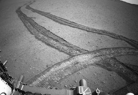
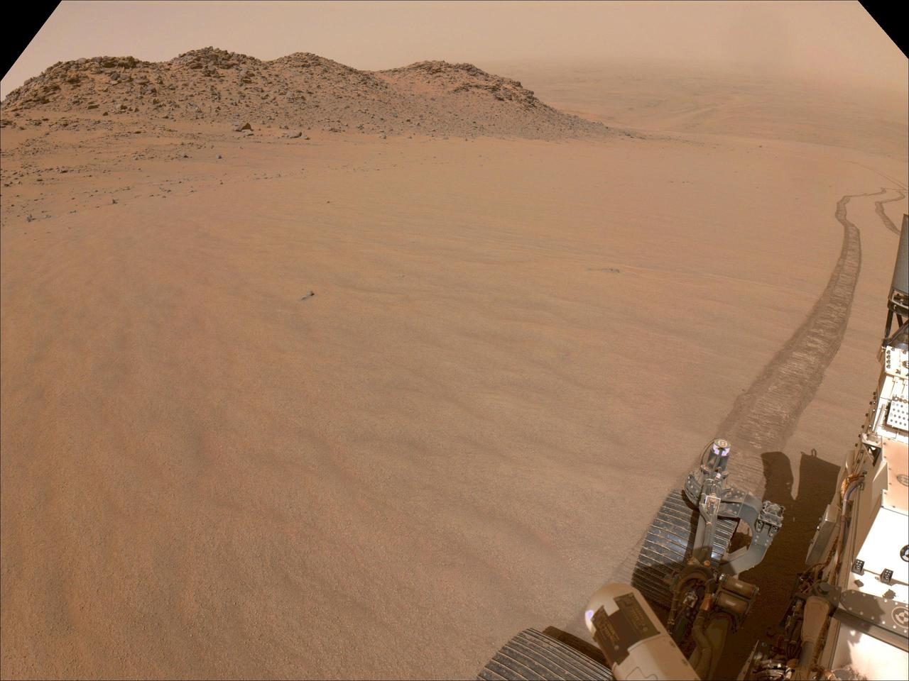
One of the navigation cameras aboard NASA's Perseverance captured this image of the tracks made by the rover during its climb up the rim of Jezero Crater on Oct. 11, 2024, the 1,295th Martian day, or sol, of the mission. The rover's tracks, seen disappearing into the distance, have churned up the regolith (broken rock and sand) on the surface, indicating high slip. The edges of the tracks are not straight or smooth, which indicates cross-track sliding during the drive. On less slippery terrain, the tracks have well defined lines from the grousers on the rover wheels. The distant river channel seen at the upper left of image is Neretva Vallis, which fed Jezero Crater with fresh water billions of years ago. A key objective for Perseverance's mission on Mars is astrobiology, including the search for signs of ancient microbial life. The rover will characterize the planet's geology and past climate, pave the way for human exploration of the Red Planet, and be the first mission to collect and cache Martian rock and regolith (broken rock and dust). Subsequent NASA missions, in cooperation with ESA (European Space Agency), would send spacecraft to Mars to collect these sealed samples from the surface and return them to Earth for in-depth analysis. The Mars 2020 Perseverance mission is part of NASA's Moon to Mars exploration approach, which includes Artemis missions to the Moon that will help prepare for human exploration of the Red Planet. https://photojournal.jpl.nasa.gov/catalog/PIA26379
NASA's Perseverance Mars rover used its right-front navigation camera to capture this first view over the rim of Jezero Crater on Dec. 10, 2024, the 1,354th Martian day, or sol, of the mission, when it reached the end of its long climb from the crater floor. The rover is looking west in this image from a location nicknamed "Lookout Hill." Not visible is "Witch Hazel Hill," a scientifically significant rocky outcrop that Perseverance is headed toward. Once there, the rover will spend about six months exploring the area. Scientists are excited to explore the region outside of Jezero because the rover will encounter rocks excavated by a monster meteor impact that formed the crater an estimated 3.9 billion years ago. These rocks could not only be early Martian crust, but among the oldest rocks found anywhere in the solar system. A key objective for Perseverance's mission on Mars is astrobiology, including the search for signs of ancient microbial life. The rover will characterize the planet's geology and past climate, pave the way for human exploration of the Red Planet, and be the first mission to collect and cache Martian rock and regolith (broken rock and dust). Subsequent NASA missions, in cooperation with ESA (European Space Agency), would send spacecraft to Mars to collect these sealed samples from the surface and return them to Earth for in-depth analysis. The Mars 2020 Perseverance mission is part of NASA's Moon to Mars exploration approach, which includes Artemis missions to the Moon that will help prepare for human exploration of the Red Planet. https://photojournal.jpl.nasa.gov/catalog/PIA26511
This annotated image of Mars' Jezero Crater depicts the ground track and waypoints of the Ingenuity Mars Helicopter's planned 11th flight, scheduled to take place no earlier than Aug. 4, 2021. It was generated using terrain imaged by the HiRISE camera aboard NASA's Mars Reconnaissance Orbiter. The goal of Flight 11 is to move Ingenuity to a new location where it can support the Perseverance rover by obtaining imagery of geologic features in the "South Seítah" area. This graphic indicates the helicopter's location at takeoff with a pale blue dot on the lower right; upper-left dots indicate its new landing site. https://photojournal.jpl.nasa.gov/catalog/PIA24690
This annotated image of the "South Séítah" region of Jezero Crater depicts the planned ground track of NASA's Ingenuity Mars Helicopter (light blue) during its 15th flight at Mars. The pale blue "X" in the upper left indicates the helicopter's location at takeoff; the pale blue dot at lower right indicates the anticipated landing site. The green lines indicate the expected sightlines that will be captured in the flight's 10 planned color images. The red "X" at upper center of the image marks the current location of NASA's Perseverance rover. The image's background terrain was generated using data collected by the HiRISE camera aboard NASA's Mars Reconnaissance Orbiter. https://photojournal.jpl.nasa.gov/catalog/PIA24977
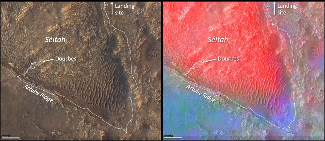
These annotated images show two views of the "Séítah" geologic unit of Mars' Jezero Crater. The map on the left shows terrain features of the crater with annotations depicting the rover's route during its first science campaign. "Artuby" is a ridgeline running along a portion of the southern boundary of Séítah. "Dourbes" is the name of an abrading target on a rock in South Séítah. The multi-hued map on the right shows the diversity of igneous (solidified from lava or magma) minerals in the same region. Olivine is shown in red. Calcium-poor pyroxene in green. Calcium-rich pyroxene is in blue. A key objective for Perseverance's mission on Mars is astrobiology, including the search for signs of ancient microbial life. The rover will characterize the planet's geology and past climate, pave the way for human exploration of the Red Planet, and be the first mission to collect and cache Martian rock and regolith (broken rock and dust). Subsequent NASA missions, in cooperation with ESA (European Space Agency), would send spacecraft to Mars to collect these sealed samples from the surface and return them to Earth for in-depth analysis. The Mars 2020 Perseverance mission is part of NASA's Moon to Mars exploration approach, which includes Artemis missions to the Moon that will help prepare for human exploration of the Red Planet. https://photojournal.jpl.nasa.gov/catalog/PIA25024
As landing technology improves and these landing ellipses shrink, missions can aim for more precise landings, opening up new areas of Mars to explore. Perseverance takes it two steps further than previous missions. First, it uses a new algorithm to time its parachute deployment based on distance to its target rather than vehicle velocity. This shrinks the landing ellipse to 4.8 miles by 4.1 miles (7.7 kilometers by 6.6 kilometers). Second, the rover uses maps stored in its memory to avoid landing hazards within that smaller ellipse during its propulsive descent phase. This allows Perseverance to target safe landing locations within Jezero Crater. The rover is set to land on Feb. 18, 2021. Improvements in interplanetary navigation tightened the landing ellipse of Mars Pathfinder in comparison with missions before it. It landed by bouncing on the surface with airbags, and has the largest ellipse in this image, measuring 124.3 miles by 43.5 miles (200 by 70 kilometers). The Phoenix and InSight landers used retrorockets to land on three legs, but still had large possible landing areas about 80.8 miles (130 kilometers) long. In 2012, the Curiosity team developed guided entry technology, shrinking its landing ellipse further. The spacecraft used small rockets to steer itself through the atmosphere as it headed toward Gale Crater. https://photojournal.jpl.nasa.gov/catalog/PIA24349
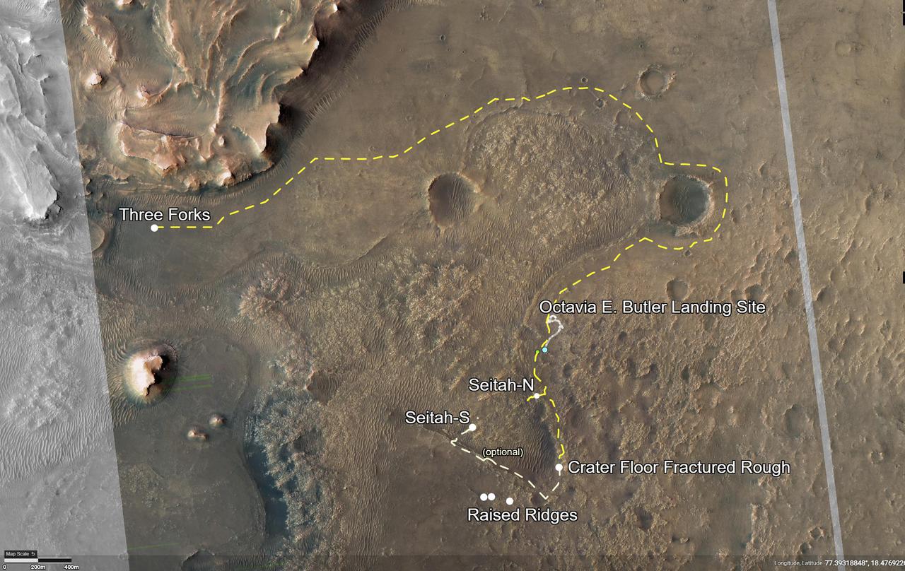
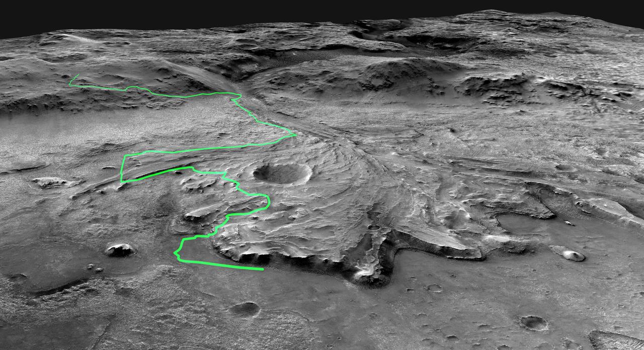
This annotated image of Mars' Jezero Crater depicts the route NASA's Perseverance rover will take during its first science campaign – as well as its path to the location of its second science campaign. The image was provided by the High Resolution Imaging Experiment (HiRISE) aboard NASA's Mars Reconnaissance orbiter. Perseverance's first science campaign sends the rover south and west of the Octavia E. Butler Landing Site to investigate and sample several of the deepest, and potentially oldest, accessible geologic units in Jezero Crater – the "Séítah" unit (which in Navajo language means "amidst the sand"), and the "Cratered Floor Fractured Rough." At the completion of the science campaign, Perseverance will return to the "Octavia E. Butler" landing site on its way north, then head west toward the location where its second science campaign will begin. The first science campaign (depicted with yellow hash marks) begins with the rover performing an arching drive southward from its landing site to Séítah-North (Séítah-N). At that point the rover will travel west a short distance to an overlook where it can view much of the Séítah unit. The "Séítah-N Overlook" could also become an area of scientific interest – with Perseverance performing a "toe dip" into the unit to collect remote-sensing measurements of geologic targets. Once its time at the Séítah-N Overlook is complete, Perseverance will head east, then south toward a spot where the science team can study the Crater Floor Fractured Rough in greater detail. The first core sample collected by the mission will also take place at this location. After Cratered Floor Fractured Rough, the Perseverance rover team will evaluate whether additional exploration (depicted with light-yellow hash marks) farther south – and then west – is warranted. Whether Perseverance travels beyond the Cratered Floor Fractured Rough during this first science campaign, the rover will eventually retrace its steps. As Perseverance passes the Octavia B. Butler landing site, the first science campaign will conclude. At that point, several months of travel lay ahead as Perseverance makes its way to "Three Forks," where the second science campaign will begin. From Three Forks, Perseverance can access geologic locations at the base of the ancient delta (the fan-shaped remains of the confluence of an ancient river and a lake), as well as ascend the delta by driving up a valley wall to the northwest. https://photojournal.jpl.nasa.gov/catalog/PIA24596

NASA's Perseverance rover puts its robotic arm to work around a rocky outcrop called "Skinner Ridge" in Mars' Jezero Crater. Composed of multiple images, this mosaic shows layered sedimentary rocks in the face of a cliff in the delta, as well as one of the locations where the rover abraded a circular patch to analyze a rock's composition. The delta is an area where, billions of years ago, a river once flowed into a lake in Jezero Crater and deposited rocks and sediments in a fan shape. Scientists consider the delta one of the best places on Mars to search for potential signs of ancient microbial life. The verification of ancient life on the Red Planet carries an enormous burden of proof. The multiple images that compose this mosaic were acquired by Perseverance's Mastcam-Z instrument between June 30 and July 8, 2022 (PDT), the 484th and 492nd Martian days, or sols, of the rover's mission. The color bands of the image have been processed to improve visual contrast and accentuate color differences. In the days after this mosaic was taken, Perseverance also extracted two classroom chalk-size pieces of rock (cylinders about 0.5 inches, or 13 millimeters, in diameter and 2.4 inches, or 60 millimeters, long) from Skinner Ridge and sealed them in ultra-clean sample tubes. A key objective for Perseverance's mission on Mars is astrobiology, including the search for signs of ancient microbial life. The rover will characterize the planet's geology and past climate, pave the way for human exploration of the Red Planet, and be the first mission to collect and cache Martian rock and regolith (broken rock and dust). Subsequent NASA missions, in cooperation with ESA (European Space Agency), would send spacecraft to Mars to collect these sealed samples from the surface and return them to Earth for in-depth analysis. The Mars 2020 Perseverance mission is part of NASA's Moon to Mars exploration approach, which includes Artemis missions to the Moon that will help prepare for human exploration of the Red Planet. https://photojournal.jpl.nasa.gov/catalog/PIA24925
This pair of images shows two cylinders of rock the size of classroom chalk inside the drill of NASA's Perseverance rover from an outcrop called "Wildcat Ridge" in Mars' Jezero Crater. The image of the rock core on the left, called "Hazeltop," was taken by Perseverance's Mastcam-Z instrument on July 25, 2022, the 509th Martian day, or sol, of the mission. The image on the right, of the rock core called "Bearwallow," was taken on Aug. 2, 2022, the 516th sol. Each core is about 0.5 inches, or 13 millimeters, in diameter and 2.4 inches, or 60 millimeters, long. They were taken from an ancient river delta in Jezero Crater, a fan-shaped area where, billions of years ago, a river once flowed into a lake and deposited rocks and sediment. Scientists interpret these rocks to be fine-grained sedimentary rocks. They appear to have formed under saltwater conditions, possibly as water from the crater's ancient lake was evaporating. These rock cores have been sealed in ultra-clean sample tubes and stored in Perseverance's Sampling and Caching System as part of the mission's search for ancient signs of microbial life. The verification of ancient life on Mars carries an enormous burden of proof. A key objective for Perseverance's mission on Mars is astrobiology, including the search for signs of ancient microbial life. The rover will characterize the planet's geology and past climate, pave the way for human exploration of the Red Planet, and be the first mission to collect and cache Martian rock and regolith (broken rock and dust). Subsequent NASA missions, in cooperation with ESA (European Space Agency), would send spacecraft to Mars to collect these sealed samples from the surface and return them to Earth for in-depth analysis. The Mars 2020 Perseverance mission is part of NASA's Moon to Mars exploration approach, which includes Artemis missions to the Moon that will help prepare for human exploration of the Red Planet. https://photojournal.jpl.nasa.gov/catalog/PIA24929

NASA's Perseverance Mars rover used its Mastcam-Z camera system to capture this view as it was ascending to the rim of Jezero Crater on Dec. 5, 2024, the 1,349th Martian day, or sol, of the mission. The scene shows just how steep some of the slopes leading to the crater rim can be. Arizona State University leads the operations of the Mastcam-Z instrument, working in collaboration with Malin Space Science Systems in San Diego, on the design, fabrication, testing, and operation of the cameras, and in collaboration with the Niels Bohr Institute of the University of Copenhagen on the design, fabrication, and testing of the calibration targets. A key objective for Perseverance's mission on Mars is astrobiology, including the search for signs of ancient microbial life. The rover will characterize the planet's geology and past climate, pave the way for human exploration of the Red Planet, and be the first mission to collect and cache Martian rock and regolith (broken rock and dust). Subsequent NASA missions, in cooperation with ESA (European Space Agency), would send spacecraft to Mars to collect these sealed samples from the surface and return them to Earth for in-depth analysis. The Mars 2020 Perseverance mission is part of NASA's Moon to Mars exploration approach, which includes Artemis missions to the Moon that will help prepare for human exploration of the Red Planet. Animation available at https://photojournal.jpl.nasa.gov/catalog/PIA26475
On ancient Mars, water carved channels and transported sediments to form fans and deltas within lake basins. Spectral data acquired by NASA Mars Reconnaissance Orbiter, indicate chemical alteration by water.
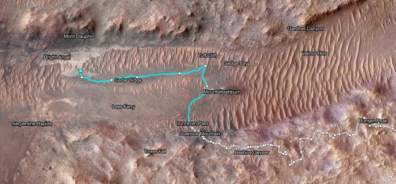
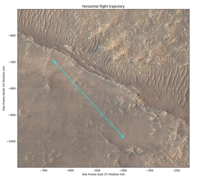
Superimposed on an image taken by the HiRISE camera aboard NASA's Mars Reconnaissance Orbiter, this map shows the path taken by the agency's Perseverance Mars rover between Jan. 31, 2024, and June 11, shortly after it arrived at a geologic area of interest the science team calls "Bright Angel." The route where the rover paralleled the Neretva Vallis river channel is depicted in white. The portion of the route where the rover was inside the river channel is depicted in pale blue. The dots along the white line signify locations where the rover stopped after completing a traverse. The University of Arizona, in Tucson, operates HiRISE, which was built by BAE Systems, in Boulder, Colorado. JPL manages the Mars Reconnaissance Orbiter Project for NASA's Science Mission Directorate, Washington. A key objective for Perseverance's mission on Mars is astrobiology, including the search for signs of ancient microbial life. The rover will characterize the planet's geology and past climate, pave the way for human exploration of the Red Planet, and be the first mission to collect and cache Martian rock and regolith (broken rock and dust). Subsequent NASA missions, in cooperation with ESA (European Space Agency), would send spacecraft to Mars to collect these sealed samples from the surface and return them to Earth for in-depth analysis. https://photojournal.jpl.nasa.gov/catalog/PIA26334
NASA's Ingenuity Mars Helicopter captured this view of an area the Mars Perseverance rover team calls "Raised Ridges" during its 10th flight at Mars on July 24, 2021. The images of the geologic feature were taken at the request of the Mars Perseverance rover science team, which was considering visiting the ridges during the first science campaign. On Earth, similar fractures in desert environments might be a clue to past liquid water activity and thus past habitability. https://photojournal.jpl.nasa.gov/catalog/PIA24689
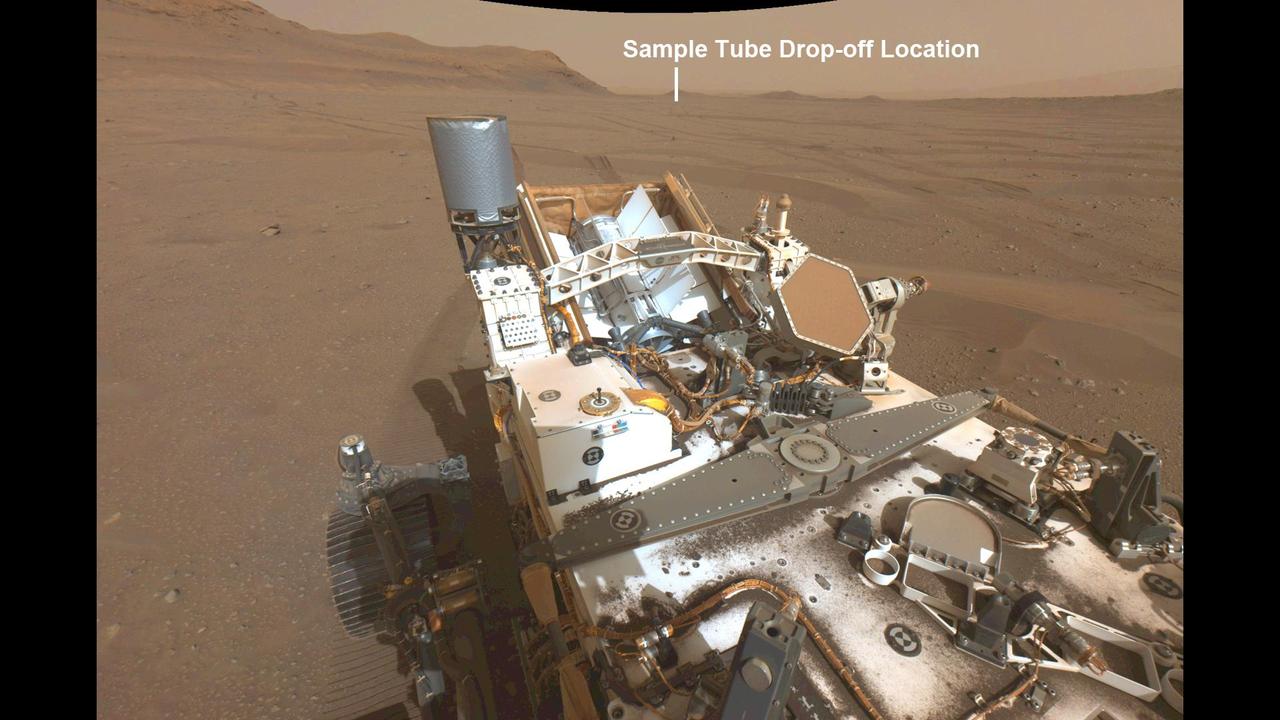
This annotated image from NASA's Perseverance Mars rover shows its wheel tracks in Jezero Crater and a distant view of the first potential location it could deposit a group of sample tubes for possible future return to Earth. The image was taken on Aug. 29, 2022, the 542nd Martian day, or sol, of the rover's mission, by Perseverance's navigation camera. Sample tubes already filled with rock are currently stored in the rover's Sampling and Caching System. Perseverance will deposit select samples in designated locations. Subsequent NASA missions, in cooperation with ESA (European Space Agency), would collect these sealed samples from the surface and return them to Earth for in-depth analysis as part of the Mars Sample Return campaign. This image has been linearized to remove optical lens distortion effects. A key objective for Perseverance's mission on Mars is astrobiology, including the search for signs of ancient microbial life. The rover will characterize the planet's geology and past climate, pave the way for human exploration of the Red Planet, and be the first mission to collect and cache Martian rock and regolith (broken rock and dust). The Mars 2020 Perseverance mission is part of NASA's Moon to Mars exploration approach, which includes Artemis missions to the Moon that will help prepare for human exploration of the Red Planet. https://photojournal.jpl.nasa.gov/catalog/PIA25243
NASA's Perseverance Mars rover is on its ascent to the rim of Jezero Crater, and it captured a portion of the journey with one of its navigation cameras. Forty-five frames were stitched together to create this video showing the rover's progress on Aug. 22, 25, and 26, 2024, the 1,247th, 1,250th, and 1251st Martian days, or sols, of the mission. During the time period captured, Perseverance covered a distance of about 530 feet (160 meters) and gained about 115 feet (35 meters) in elevation. A key objective for Perseverance's mission on Mars is astrobiology, including the search for signs of ancient microbial life. The rover will characterize the planet's geology and past climate, pave the way for human exploration of the Red Planet, and be the first mission to collect and cache Martian rock and regolith (broken rock and dust). Subsequent NASA missions, in cooperation with ESA (European Space Agency), would send spacecraft to Mars to collect these sealed samples from the surface and return them to Earth for in-depth analysis. The Mars 2020 Perseverance mission is part of NASA's Moon to Mars exploration approach, which includes Artemis missions to the Moon that will help prepare for human exploration of the Red Planet. Animation available at https://photojournal.jpl.nasa.gov/catalog/PIA26376
This annotated image of Mars' Jezero Crater depicts the ground track and waypoints of the Ingenuity Mars Helicopter's planned tenth flight, scheduled to take place no earlier than Saturday, July 24. The image was generated using terrain imaged by the HiRISE camera aboard NASA's Mars Reconnaissance Orbiter. The goal of Flight 10 is to obtain 3D imagery of geologic features that are of interest to the agency's Perseverance rover science team. The pale-blue dots indicate mission waypoints. The first and last waypoints provide takeoff and landing locations. Waypoints 2 through 9 indicate where Ingenuity's color Return to Earth (RTE) camera will take pictures that could be made into stereo images. https://photojournal.jpl.nasa.gov/catalog/PIA24687
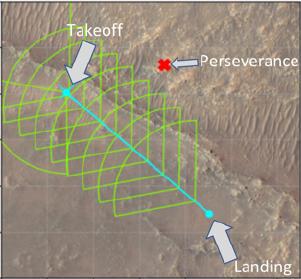
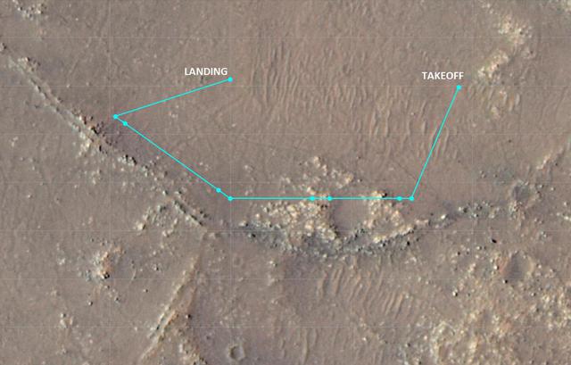
This annotated overhead image from NASA's Mars Reconnaissance Orbiter (MRO) depicts the multiple flights – and two different routes – the agency's Ingenuity Mars Helicopter could take on its way to Jezero Crater's delta. The location of Ingenuity as of March 14, 2022, is indicated by the red dot. This map is made using images from MRO's High Resolution Imaging Experiment (HiRISE) camera. The first flight in this series (indicated by the number 1 in blue) occurred on March 10, 2022. After the next flight – which includes a sharp bend in the course to avoid a large hill – the helicopter team will consider which of two routes to take. The first option requires two flights to reach the base of the delta. The second option is more direct, necessitating only one final flight to reach the same location. https://photojournal.jpl.nasa.gov/catalog/PIA25080
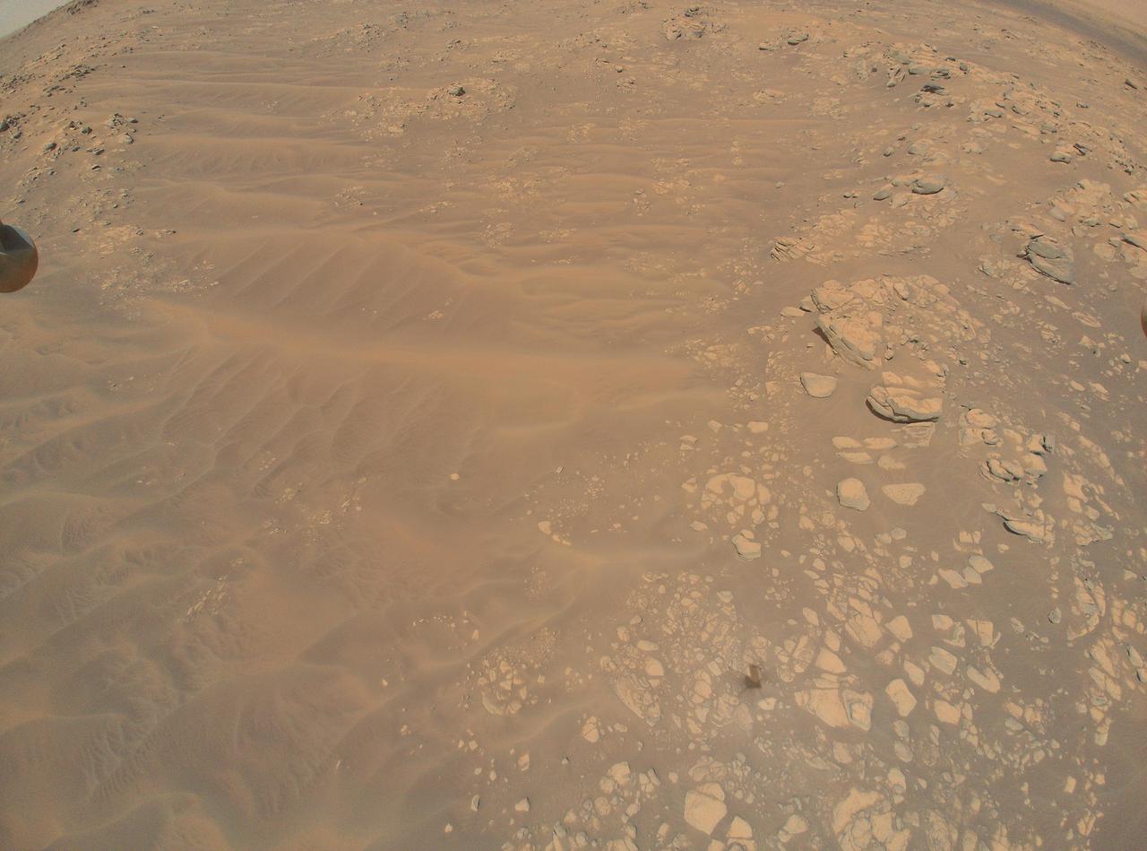
This image sand dunes, boulders, and rocky outcrops of the "South Séítah" region of Mars' Jezero Crater was captured by NASA's Ingenuity Mars Helicopter during its 12th flight, on August 16, 2021. Ingenuity's shadow is visible in the lower third of the image, just right of center. A portion of the foot on one of the helicopter's four landing legs is visible along the upper-left edge of the image. In the upper-right corner (arching toward the top middle of the image) is a ridgeline that is of interest to the Perseverance rover science team. Taken from an altitude of 33 feet (10 meters), the image is one of 10 collected during the flight at the request of the Mars Perseverance rover science team, which is considering whether to explore the location further. https://photojournal.jpl.nasa.gov/catalog/PIA24801
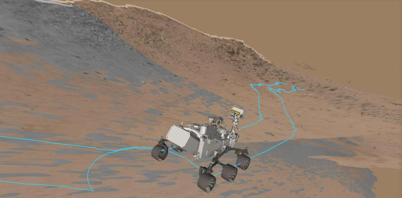
This animation captured from NASA's rover driving software depicts the agency's Perseverance during a slippery drive as it ascends toward the rim of Mars' Jezero Crater on Oct. 16, 2024, the 1,301st Martian day, or sol, of the mission. A key objective for Perseverance's mission on Mars is astrobiology, including the search for signs of ancient microbial life. The rover will characterize the planet's geology and past climate, pave the way for human exploration of the Red Planet, and be the first mission to collect and cache Martian rock and regolith (broken rock and dust). Subsequent NASA missions, in cooperation with ESA (European Space Agency), would send spacecraft to Mars to collect these sealed samples from the surface and return them to Earth for in-depth analysis. The Mars 2020 Perseverance mission is part of NASA's Moon to Mars exploration approach, which includes Artemis missions to the Moon that will help prepare for human exploration of the Red Planet. Animation available at https://photojournal.jpl.nasa.gov/catalog/PIA26514
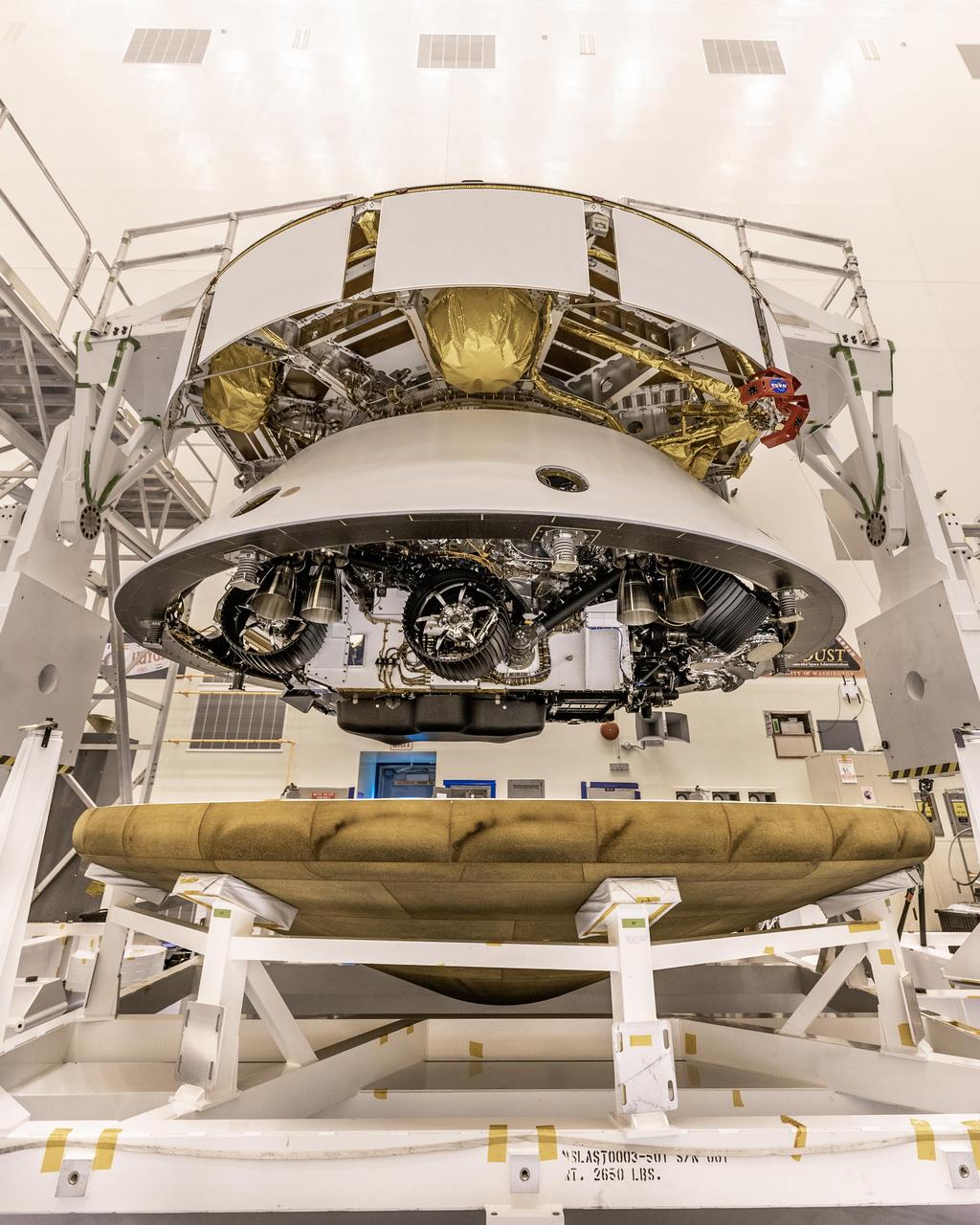
The Mars 2020 Perseverance rover mission's disk-shaped cruise stage sits atop the bell-shaped back shell, which contains the powered descent stage and Perseverance rover. Below is the brass-colored heat shield that is about to be attached to the back shell. The image was taken on May 28, 2020, at Kennedy Space Center in Florida. The next time the back shell and cruise stage will separate will be about 6 miles (9 kilometers) above Mars' Jezero Crater on Feb. 18, 2021. https://photojournal.jpl.nasa.gov/catalog/PIA23925
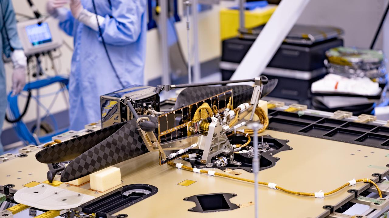
The Mars Helicopter and its Mars Helicopter Delivery System were attached to the Perseverance Mars rover at Kennedy Space Center on April 6, 2020. A shell (not pictured) will protect the helicopter during the rover's descent to the surface of Jezero Crater on Feb. 18, 2021. The helicopter will be deployed about two-and-a-half months after Perseverance lands. https://photojournal.jpl.nasa.gov/catalog/PIA23823
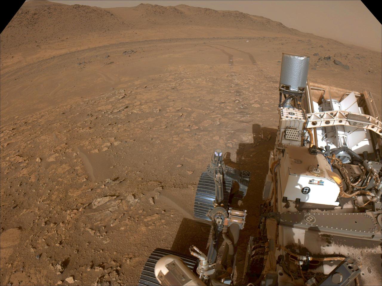
One of the navigation cameras aboard NASA's Perseverance rover captured this view as the rover left the "Bright Angel" area of Mars' Jezero Crater on July 30, 2024, the 1,224th Martian day, or sol, of the mission. A key objective for Perseverance's mission on Mars is astrobiology, including the search for signs of ancient microbial life. The rover will characterize the planet's geology and past climate, pave the way for human exploration of the Red Planet, and be the first mission to collect and cache Martian rock and regolith (broken rock and dust). https://photojournal.jpl.nasa.gov/catalog/PIA26372
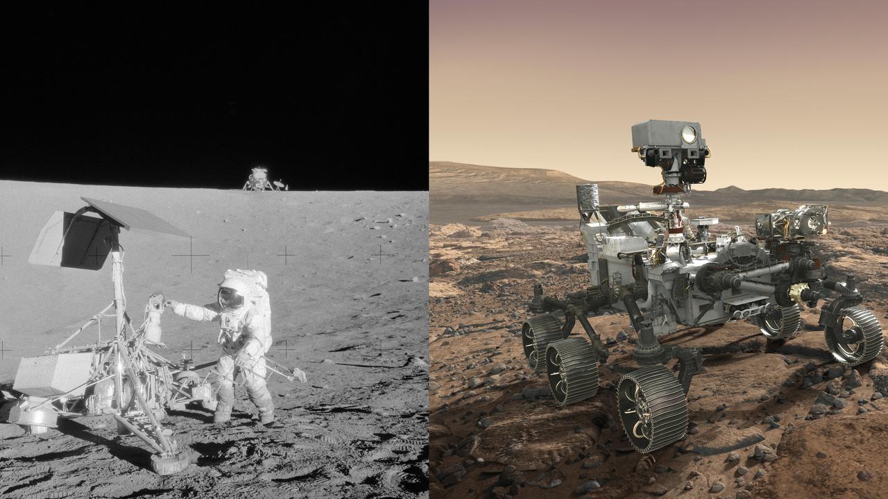
(Left) Apollo 12 astronaut Charles "Pete" Conrad Jr. stands beside NASA's Surveyor 3 spacecraft; the lunar module Intrepid can be seen in the distance. Apollo 12 landed on the Moon's Ocean of Storms on Nov. 20, 1969. (Right) Mars 2020 rover, seen here in an artist's concept, will make history's most accurate landing on a planetary body when it lands at Mars' Jezero Crater on Feb. 18, 2021. https://photojournal.jpl.nasa.gov/catalog/PIA23553

In February 2021, NASA's Mars 2020 Perseverance rover and NASA's Ingenuity Mars Helicopter (shown in an artist's concept) will be the agency's two newest explorers on Mars. Both were named by students as part of an essay contest. Perseverance is the most sophisticated rover NASA has ever sent to Mars. Ingenuity, a technology experiment, will be the first aircraft to attempt controlled flight on another planet. Perseverance will arrive at Mars' Jezero Crater with Ingenuity attached to its belly. https://photojournal.jpl.nasa.gov/catalog/PIA23962
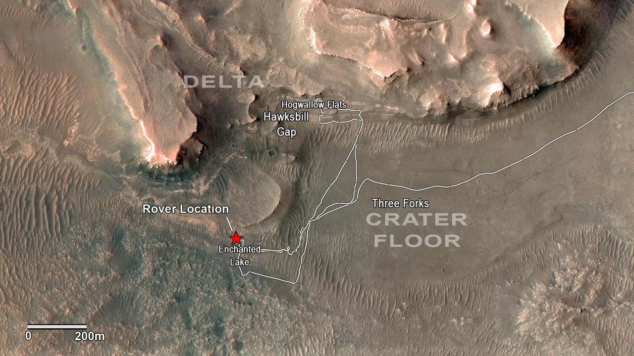
NASA's Perseverance rover has been investigating rocks at the front of the delta in Mars' Jezero Crater along the path indicated in this annotated image taken by the agency's Mars Reconnaissance Orbiter (MRO). The red star indicates the location of the rover in September 2022. Perseverance touched down at "Octavia E. Butler Landing" on the floor of Jezero Crater on Feb. 18, 2021. It reached the delta in April 2022. The delta is a fan-shaped feature where, billions of years ago, a river flowed into a lake and deposited rocks and sediments. Scientists consider the delta one of the best places on Mars to search for potential signs of ancient microbial life. The annotations show the names of some of the key features Perseverance visited, such as "Enchanted Lake" and "Hogwallow Flats." Sample tubes already filled with rock are currently stored in the rover's Sampling and Caching System. Perseverance will deposit select samples in designated locations. MRO took this overhead image with its High Resolution Imaging Science Experiment (HiRISE) camera. A key objective for Perseverance's mission on Mars is astrobiology, including the search for signs of ancient microbial life. The rover will characterize the planet's geology and past climate, pave the way for human exploration of the Red Planet, and be the first mission to collect and cache Martian rock and regolith (broken rock and dust). Subsequent NASA missions, in cooperation with ESA (European Space Agency), would send spacecraft to Mars to collect these sealed samples from the surface and return them to Earth for in-depth analysis. The Mars 2020 Perseverance mission is part of NASA's Moon to Mars exploration approach, which includes Artemis missions to the Moon that will help prepare for human exploration of the Red Planet. https://photojournal.jpl.nasa.gov/catalog/PIA24923

NASA's Perseverance Mars rover used its dual-camera Mastcam-Z imager to capture this image of "Santa Cruz," a hill about 1.5 miles (2.5 kilometers) away from the rover, on April 29, 2021, the 68th Martian day, or sol, of the mission. The entire scene is inside of Mars' Jezero Crater; the crater's rim can be seen on the horizon line beyond the hill. This scene is not white balanced; instead, it is displayed in a preliminary calibrated version of a natural-color composite, approximately simulating the colors of the scene as it would appear to a person on Mars. Arizona State University in Tempe leads the operations of the Mastcam-Z instrument, working in collaboration with Malin Space Science Systems in San Diego. A key objective for Perseverance's mission on Mars is astrobiology, including the search for signs of ancient microbial life. The rover will characterize the planet's geology and past climate, pave the way for human exploration of the Red Planet, and be the first mission to collect and cache Martian rock and regolith (broken rock and dust). Subsequent NASA missions, in cooperation with ESA (European Space Agency), would send spacecraft to Mars to collect these sealed samples from the surface and return them to Earth for in-depth analysis. The Mars 2020 Perseverance mission is part of NASA's Moon to Mars exploration approach, which includes Artemis missions to the Moon that will help prepare for human exploration of the Red Planet. https://photojournal.jpl.nasa.gov/catalog/PIA24546
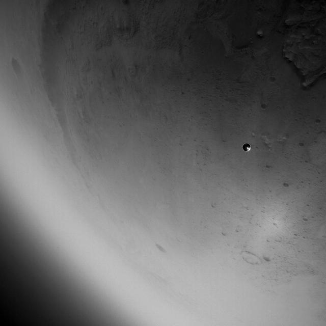
The heat shield drops away toward Mars after being released from the Mars 2020 back shell during the spacecraft's descent through the Martian atmosphere on Feb. 18, 2021. The heat shield and back shell encapsulated NASA's Perseverance rover on its journey to the Red Planet. This image was taken by the rover's Lander Vision System Camera (LCAM), serving as part of the Terrain-Relative Navigation system. This was the first use at Mars of the system, which compared images from below the spacecraft to an onboard map, helping to guide the spacecraft to a safe landing spot in Jezero Crater. Past missions had deemed Jezero Crater too hazardous to be a landing site because of its cliffs, dunes, and boulders. The LCAM generates 1024x1024 pixel grayscale images across a 90x90-degree field of view. The exposure time for each image is just under 150 microseconds, which enables crisp images during descent. LCAM was provided by Malin Space Science Systems in San Diego; the Perseverance rover was built and is operated by NASA's Jet Propulsion Laboratory in Southern California. JPL is a division of Caltech in Pasadena. https://photojournal.jpl.nasa.gov/catalog/PIA24447
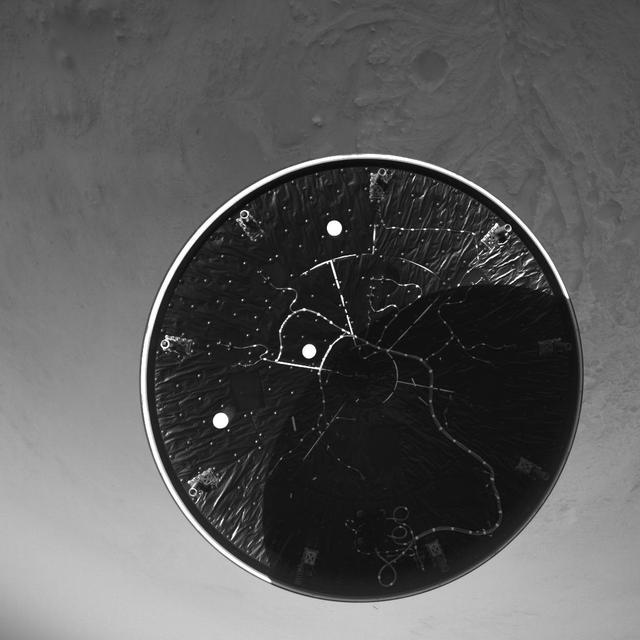
The heat shield drops away toward Mars after being released from the Mars 2020 back shell during the spacecraft's descent through the Martian atmosphere on Feb. 18, 2021. The heat shield and back shell encapsulated NASA's Perseverance rover on its journey to the Red Planet. This image was taken by the rover's Lander Vision System Camera (LCAM), serving as part of the Terrain-Relative Navigation system. This was the first use at Mars of the system, which compared images from below the spacecraft to an onboard map, helping to guide the spacecraft to a safe landing spot in Jezero Crater. Past missions had deemed Jezero Crater too hazardous to be a landing site because of its cliffs, dunes, and boulders. The LCAM generates 1024x1024 pixel grayscale images across a 90x90-degree field of view. The exposure time for each image is just under 150 microseconds, which enables crisp images during descent. LCAM was provided by Malin Space Science Systems in San Diego; the Perseverance rover was built and is operated by NASA's Jet Propulsion Laboratory in Southern California. JPL is a division of Caltech in Pasadena. https://photojournal.jpl.nasa.gov/catalog/PIA24446
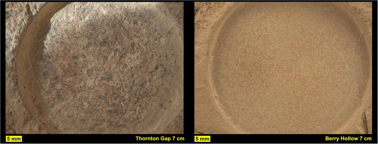
This pair of images from NASA's Perseverance shows close-up views of two rock types the rover investigated in the delta area of Mars' Jezero Crater, which scientists consider one of the best places on the Red Planet to search for potential signs of ancient microbial life. The image on the left shows a circular patch Perseverance abraded on a rocky outcrop called "Skinner Ridge," while the image on the right shows an abrasion patch on a rocky outcrop called "Wildcat Ridge." Under each image is the abrasion patch's name the mission team has provided them for identification purposes. Perseverance grinds circular patches into rocks so its science instruments can analyze the rocks' composition. The images were taken by the WATSON (Wide Angle Topographic Sensor for Operations and eNgineering) camera on the SHERLOC (Scanning Habitable Environments with Raman & Luminescence for Organics & Chemicals) instrument on June 29 and July 21, 2022, the 482nd and 504th Martian days, or sols, of the mission. The camera that took these images, located at the end of Perseverance's robotic arm, was about 3 inches (7 centimeters) away from each rock surface. The Skinner Ridge rock is sandstone and composed of much larger grains than the Wildcat Ridge rock. The rock and mineral fragments at Skinner Ridge – which are the detritus of larger rocks – have a diversity of compositions and were transported by water from possibly hundreds of miles outside of Jezero Crater. The Wildcat Ridge rock is a more finely grained sedimentary rock, a sulfate-bearing mudstone. It has a more homogeneous composition than Skinner Ridge and appears to have formed in saltwater in the distant past, possibly as ancient lake water evaporated. Scientists believe both rocks formed in, and preserve information about, potentially habitable environments in Mars' ancient past. The verification of ancient life on the Red Planet carries an enormous burden of proof. Perseverance collected rock samples beside these abrasion patches (see PIA24927 and PIA24929) and sealed them in ultra-clean sample tubes. A key objective for Perseverance's mission on Mars is astrobiology, including the search for signs of ancient microbial life. The rover will characterize the planet's geology and past climate, pave the way for human exploration of the Red Planet, and be the first mission to collect and cache Martian rock and regolith (broken rock and dust). Subsequent NASA missions, in cooperation with ESA (European Space Agency), would send spacecraft to Mars to collect these sealed samples from the surface and return them to Earth for in-depth analysis. The Mars 2020 Perseverance mission is part of NASA's Moon to Mars exploration approach, which includes Artemis missions to the Moon that will help prepare for human exploration of the Red Planet. https://photojournal.jpl.nasa.gov/catalog/PIA24926

The route (shown in blue) that the agency's Perseverance Mars rover is expected to take as it climbs up the western rim of Jezero Crater is superimposed on this image taken by the HiRISE camera aboard NASA's Mars Reconnaissance Orbiter. At upper right is "Serpentine Rapids," the final geologic location of interest for the Perseverance science team before the rover begins its ascent. "Dox Castle" is a region the science team would like to explore during the rover's ascent. Two of the first regions the science team wants study at the top of the crater are "Pico Turquino" and "Witch Hazel Hill." Imagery from NASA's Mars orbiters indicates that Pico Turquino contains ancient fractures that may have been caused by hydrothermal activity in the distant past. Orbital views of Witch Hazel show layered materials that likely date from a time when Mars had a very different climate than today. Those views have revealed light-toned bedrock similar to what was found at "Bright Angel," the area where Perseverance recently discovered and sampled the "Cheyava Falls" rock, which exhibits chemical signatures and structures that could possibly have been formed by life billions of years ago when the area contained running water. The distance the rover will drive to get from Serpentine Rapids to the Aurora Park/Pico Turquino area is about 1.1 miles (1.8 kilometers); the change in elevation between the two locations is about 980 feet (300 meters). The distance covered to go from Aurora Park/Pico Turquino to Witch Hazel Hill is about 1.2 miles (2,000 meters) and the change in elevation is about 820 feet (250 meters). The University of Arizona, in Tucson, operates HiRISE, which was built by BAE Systems, in Boulder, Colorado. JPL manages the Mars Reconnaissance Orbiter Project for NASA's Science Mission Directorate, Washington. A key objective for Perseverance's mission on Mars is astrobiology, including the search for signs of ancient microbial life. The rover will characterize the planet's geology and past climate, pave the way for human exploration of the Red Planet, and be the first mission to collect and cache Martian rock and regolith (broken rock and dust). https://photojournal.jpl.nasa.gov/catalog/PIA26374
NASA's Mars 2020 Perseverance rover reached its halfway point to Jezero Crater on Oct. 27, 2020 at 1:40 p.m. PDT (4:40 EDT), having completed as many miles — 146.3 million miles (235.4 million kilometers) — as it has yet to travel on its journey to Mars. In straight-line distance, Earth is 26.6 million miles (42.7 million kilometers) behind Perseverance, and Mars is 17.9 million miles (28.8 million kilometers) in front. This illustration depicts the curved trajectory of the spacecraft (seen in inset: cruise stage, descent stage, back shell, and heat shield, plus the rover and Mars Helicopter), noting the positions of Earth and Mars relative to each other both at the time of launch and the time of landing. The trajectory's curvature is a result of the Sun's gravitational influence on the spacecraft. https://photojournal.jpl.nasa.gov/catalog/PIA24232

This image was captured while NASA's Perseverance rover drove on Mars for the first time on March 4, 2021. One of Perseverance's Hazard Avoidance Cameras (Hazcams) captured this image as the rover completed a short traverse and turn from its landing site in Jezero Crater. A key objective for Perseverance's mission on Mars is astrobiology, including the search for signs of ancient microbial life. The rover will characterize the planet's geology and past climate, pave the way for human exploration of the Red Planet, and be the first mission to collect and cache Martian rock and regolith (broken rock and dust). Subsequent NASA missions, in cooperation with ESA (European Space Agency), would send spacecraft to Mars to collect these sealed samples from the surface and return them to Earth for in-depth analysis. The Mars 2020 Perseverance mission is part of NASA's Moon to Mars exploration approach, which includes Artemis missions to the Moon that will help prepare for human exploration of the Red Planet. https://photojournal.jpl.nasa.gov/catalog/PIA24482
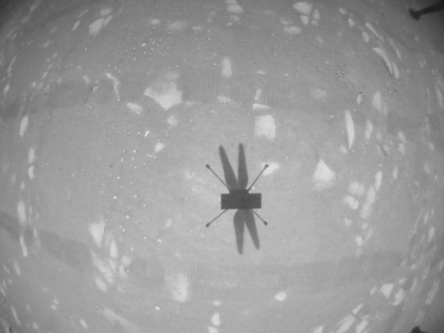
The downward-looking navigation camera aboard NASA's Ingenuity Mars Helicopter took this image of the rotorcraft's shadow on the surface of Jezero Crater during helicopter's second experimental test flight on April 22, 2021. The helicopter's navigation camera autonomously tracks the ground during flight. The Ingenuity Mars Helicopter was built by JPL, which also manages this technology demonstration project for NASA Headquarters. It is supported by NASA's Science Mission Directorate, Aeronautics Research Mission Directorate, and Space Technology Mission Directorate. NASA's Ames Research Center and Langley Research Center provided significant flight performance analysis and technical assistance during Ingenuity's development. A key objective for Perseverance's mission on Mars is astrobiology, including the search for signs of ancient microbial life. The rover will characterize the planet's geology and past climate, pave the way for human exploration of the Red Planet, and be the first mission to collect and cache Martian rock and regolith (broken rock and dust). Subsequent NASA missions, in cooperation with ESA (European Space Agency), would send spacecraft to Mars to collect these sealed samples from the surface and return them to Earth for in-depth analysis. The Mars 2020 Perseverance mission is part of NASA's Moon to Mars exploration approach, which includes Artemis missions to the Moon that will help prepare for human exploration of the Red Planet. https://photojournal.jpl.nasa.gov/catalog/PIA24592
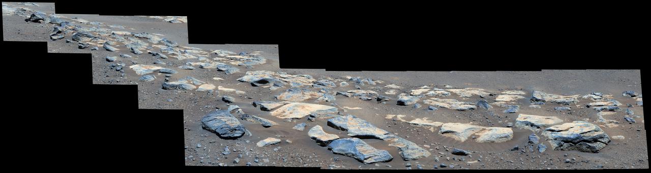
This mosaic image (composed of multiple individual images taken by NASA's Perseverance rover) shows a rock outcrop in the area nicknamed "Citadelle" on the floor of Mars' Jezero Crater. The mosaic image has been nicknamed "Malamaire" by the rover team and includes a block of rock called "Rochette" (after "La Rochette," a small town in north-central France whose name also translates to "little rock"). Perseverance successfully collected its first two rock samples from Rochette in early September 2021. An annotated version of this panorama shows the location of Rochette. The images in the mosaic were taken by the Mastcam-Z instrument on the 180th sol (Martian day) of the rover's mission. A key objective for Perseverance's mission on Mars is astrobiology, including the search for signs of ancient microbial life. The rover will characterize the planet's geology and past climate, pave the way for human exploration of the Red Planet, and be the first mission to collect and cache Martian rock and regolith (broken rock and dust). The Mars 2020 Perseverance mission is part of NASA's Moon to Mars exploration approach, which includes Artemis missions to the Moon that will help prepare for human exploration of the Red Planet. Subsequent NASA missions, in cooperation with ESA (European Space Agency), would send spacecraft to Mars to collect these sealed samples from the surface and return them to Earth for in-depth analysis. https://photojournal.jpl.nasa.gov/catalog/PIA24833
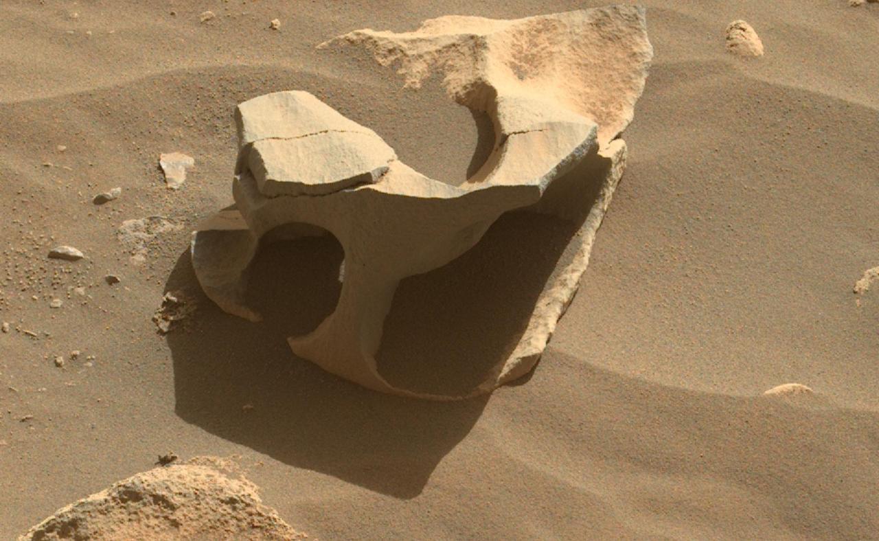
NASA's Perseverance Mars rover spotted this hollowed-out rock in Jezero Crater using its Mastcam-Z instrument on June 26, 2023, the 836th Martian day, or sol, of the mission. Wind can erode all sorts of strange shapes by sandblasting rock surfaces over the course of eons. Arizona State University leads the operations of the Mastcam-Z instrument, working in collaboration with Malin Space Science Systems in San Diego, on the design, fabrication, testing, and operation of the cameras, and in collaboration with the Niels Bohr Institute of the University of Copenhagen on the design, fabrication, and testing of the calibration targets. A key objective for Perseverance's mission on Mars is astrobiology, including the search for signs of ancient microbial life. The rover will characterize the planet's geology and past climate, pave the way for human exploration of the Red Planet, and be the first mission to collect and cache Martian rock and regolith (broken rock and dust). Subsequent NASA missions, in cooperation with ESA (European Space Agency), would send spacecraft to Mars to collect these sealed samples from the surface and return them to Earth for in-depth analysis. The Mars 2020 Perseverance mission is part of NASA's Moon to Mars exploration approach, which includes Artemis missions to the Moon that will help prepare for human exploration of the Red Planet. https://photojournal.jpl.nasa.gov/catalog/PIA25917
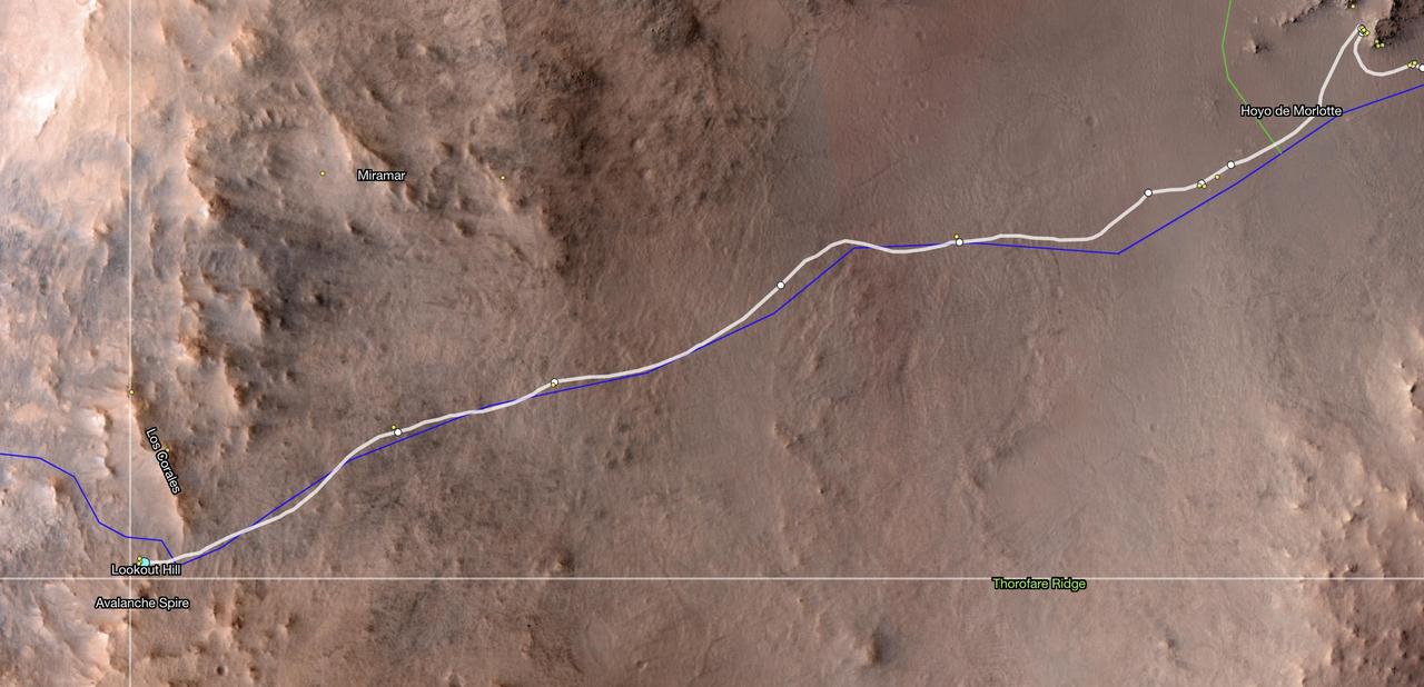
This map shows the location of NASA's Perseverance Mars rover as of Dec. 10, 2024, the 1,354th Martian day, or sol, of the mission, which it reached "Lookout Hill" at the top of Jezero Crater's rim after a monthslong climb. This map was made using data from NASA's Mars Reconnaissance Orbiter's High-Resolution Imaging Science Experiment (HiRISE) camera as well as the European Space Agency's (ESA) High Resolution Stereo Camera (HRSC). The University of Arizona, in Tucson, operates HiRISE, which was built by Ball Aerospace & Technologies Corp., in Boulder, Colorado, NASA's Jet Propulsion Laboratory manages the Mars Reconnaissance Orbiter Project for NASA's Science Mission Directorate, Washington. A key objective for Perseverance's mission on Mars is astrobiology, including the search for signs of ancient microbial life. The rover will characterize the planet's geology and past climate, pave the way for human exploration of the Red Planet, and be the first mission to collect and cache Martian rock and regolith (broken rock and dust). Subsequent NASA missions, in cooperation with ESA (European Space Agency), would send spacecraft to Mars to collect these sealed samples from the surface and return them to Earth for in-depth analysis. The Mars 2020 Perseverance mission is part of NASA's Moon to Mars exploration approach, which includes Artemis missions to the Moon that will help prepare for human exploration of the Red Planet. https://photojournal.jpl.nasa.gov/catalog/PIA26512

This image was acquired on May 30, 2018 by NASA's Mars Reconnaissance Orbiter. This image shows inverted channels within a fan whose origin could be either fluvial (produced by the action of a stream) or alluvial (created by sedimentary deposits). If the fan is alluvial, then it formed on dry land. If the fan is fluvial, then it could have formed in water, like a delta. Similar fans with inverted channels are found in Eberswalde and Jezero craters, both of which are interpreted as deltas and are considered candidate locations of future rover landing sites. More information is available at https://photojournal.jpl.nasa.gov/catalog/PIA22683
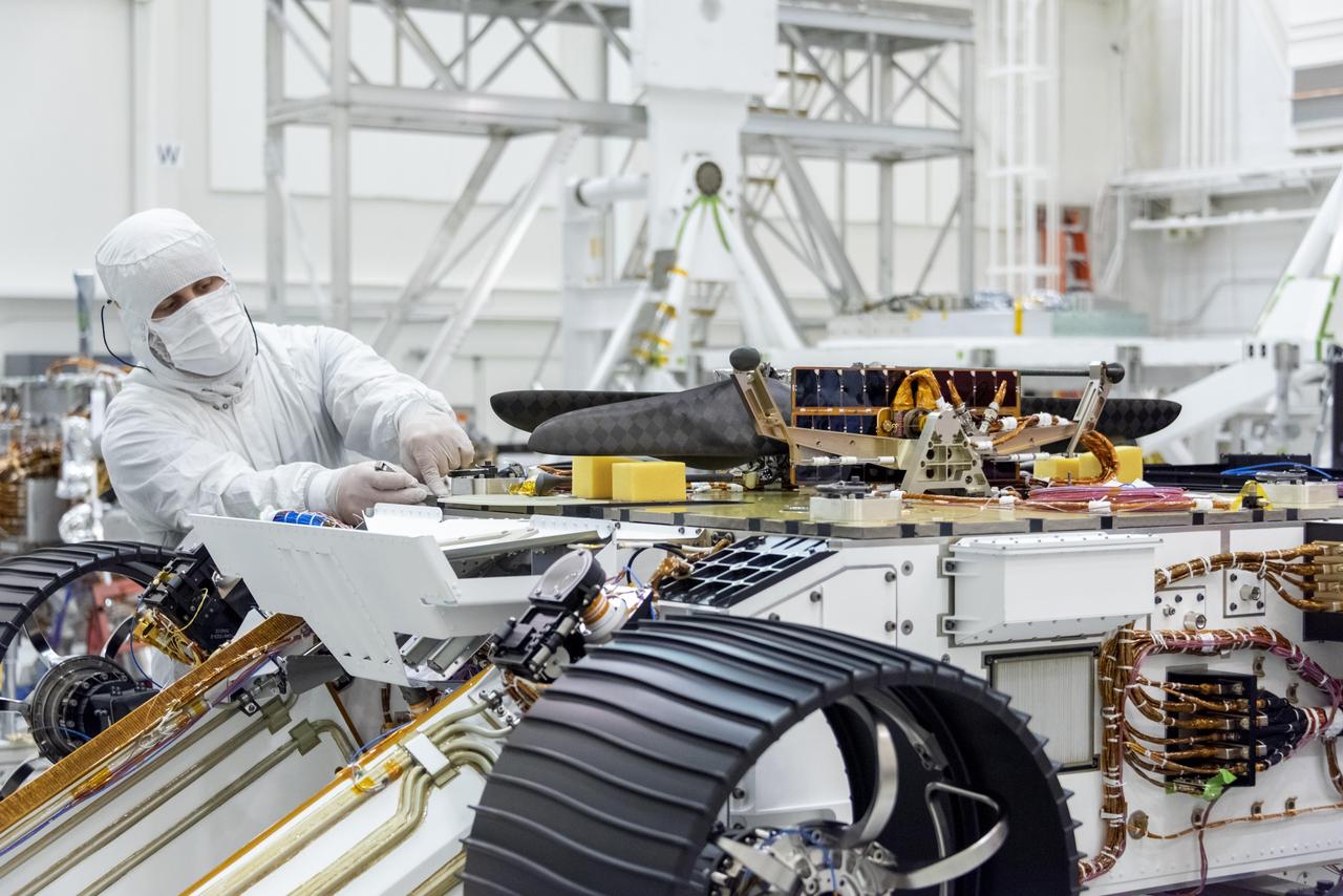
An engineer works on attaching NASA's Mars Helicopter to the belly of the Mars 2020 rover — which has been flipped over for that purpose — on Aug. 28, 2019, at the Jet Propulsion Laboratory in Pasadena, California. The twin-rotor, solar-powered helicopter was mechanically connected, along with the Mars Helicopter Delivery System, to a plate on the rover's belly that includes a cover to shield the helicopter from debris during entry, descent and landing. The helicopter will remain encapsulated after landing, deploying to the surface once a suitable area to conduct test flights is found at Jezero Crater, the rover's destination. https://photojournal.jpl.nasa.gov/catalog/PIA23372
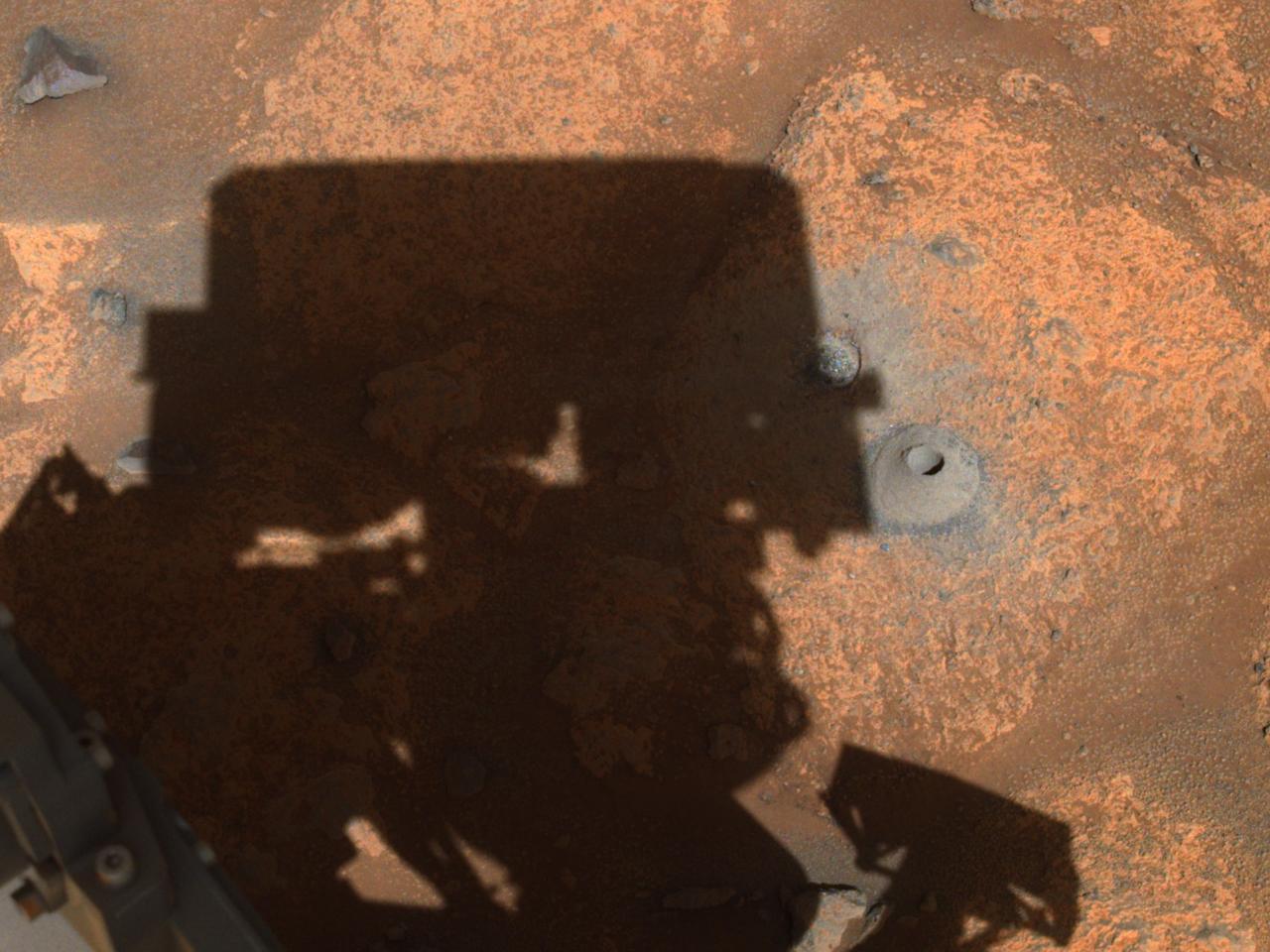
This image of the hole drilled by NASA's Perseverance rover during its first sample-collection attempt was imaged by one of the rover's navigation cameras. The photo was taken on August 6, 2021, in the "Crater Floor Fractured Rough" geologic unit in Mars' Jezero Crater. A key objective for Perseverance's mission on Mars is astrobiology, including the search for signs of ancient microbial life. The rover will characterize the planet's geology and past climate, pave the way for human exploration of the Red Planet, and be the first mission to collect and cache Martian rock and regolith (broken rock and dust). Subsequent NASA missions, in cooperation with ESA (European Space Agency), would send spacecraft to Mars to collect these sealed samples from the surface and return them to Earth for in-depth analysis. The Mars 2020 Perseverance mission is part of NASA's Moon to Mars exploration approach, which includes Artemis missions to the Moon that will help prepare for human exploration of the Red Planet. https://photojournal.jpl.nasa.gov/catalog/PIA24798

This view of the interior of Belva Crater was generated using data collected by the Mastcam-Z instrument aboard NASA's Perseverance Mars rover on April 22, 2023, the 772nd Martian day, or sol, of the mission. When the 152 individual images that make up this mosaic were taken, the rover was parked at the west side of the crater's rim, on a light-toned rocky outcrop the science team is calling "Echo Creek." Belva Crater is about 0.6 miles (0.9 kilometers) in diameter. The view here is looking across the crater towards the distant east-northeast wall of the much-larger Jezero Crater (center of the image), some 25 miles (40 kilometers) away. Impact craters like Belva can offer grand views and contain vertical cuts that provide important clues to the geologic history of the area. The mosaic shows multiple locations of bedrock exposed in vertical cross-section. One of these exposed sections of bedrock (located on the hill seen between the 60 and 75 hashmarks) is angled steeply downward and is nearly 65 feet (20 meters) tall. Called "dipping beds," such a steeply angled bedrock section could indicate the presence of a large Martian sandbar made of sediment that billions of years ago was deposited by a river flowing into the lake that Jezero Crater once held. The most distant point on Belva Crater's rim (just to the left of center in the mosaic) is about 3,500 feet (1,060 meters) away from the rover. The large boulder seen in the far right of the mosaic is about 65 feet (20 meters) away and is about 5 feet (1.5 meters) in diameter. Arizona State University leads the operations of the Mastcam-Z instrument, working in collaboration with Malin Space Science Systems in San Diego, on the design, fabrication, testing, and operation of the cameras, and in collaboration with the Niels Bohr Institute of the University of Copenhagen on the design, fabrication, and testing of the calibration targets. A key objective for Perseverance's mission on Mars is astrobiology, including the search for signs of ancient microbial life. The rover will characterize the planet's geology and past climate, pave the way for human exploration of the Red Planet, and be the first mission to collect and cache Martian rock and regolith (broken rock and dust). Subsequent NASA missions, in cooperation with ESA (European Space Agency), would send spacecraft to Mars to collect these sealed samples from the surface and return them to Earth for in-depth analysis. The Mars 2020 Perseverance mission is part of NASA's Moon to Mars exploration approach, which includes Artemis missions to the Moon that will help prepare for human exploration of the Red Planet. https://photojournal.jpl.nasa.gov/catalog/PIA25889
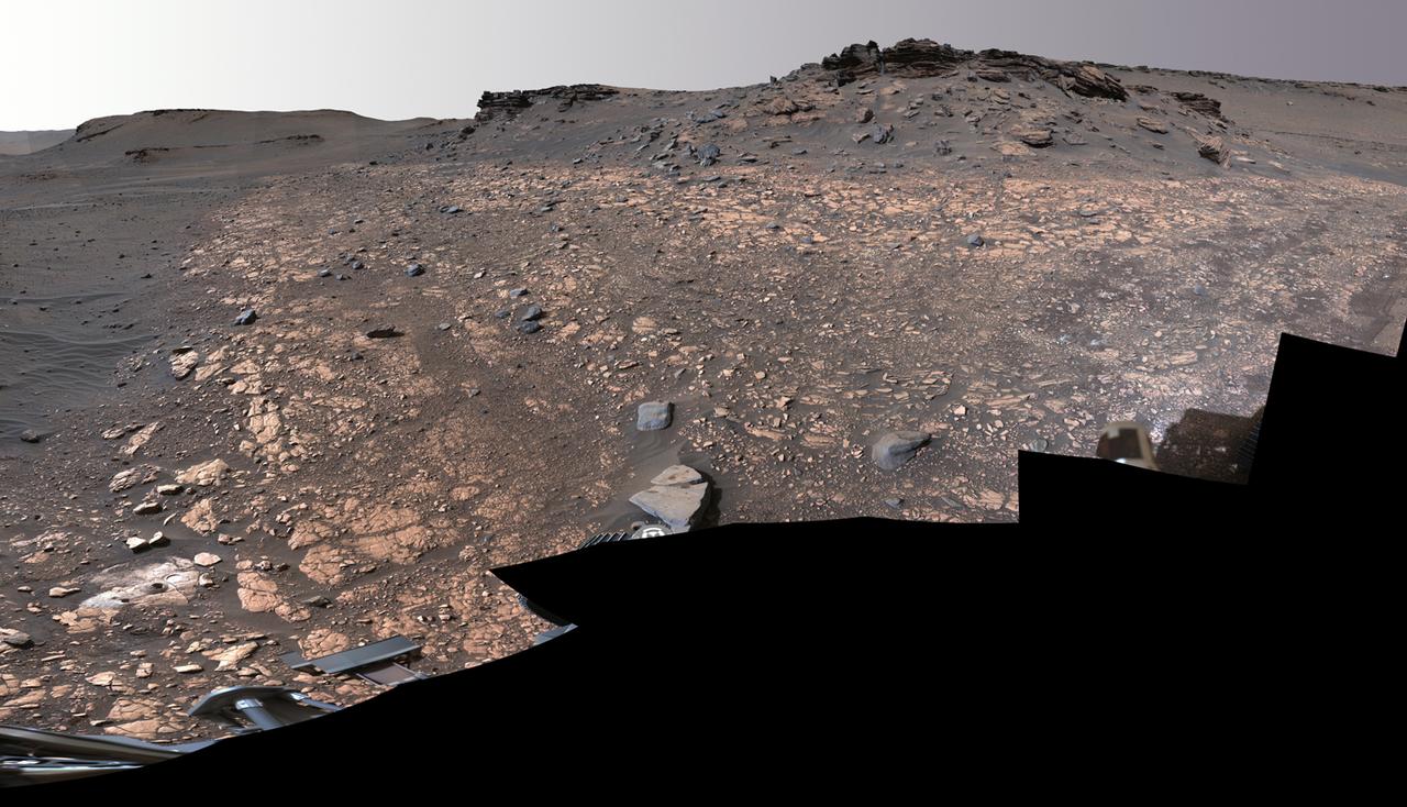
This image shows two locations in Mars's Jezero Crater where NASA's Perseverance rover collected rock samples for possible return to Earth in the future: "Wildcat Ridge" (lower left) and "Skinner Ridge" (upper right). These two outcrops are within about 70 feet (20 meters) of each other. The rover cored two cylinders of rock the size of classroom chalk (about 0.5 inches, or 13 millimeters, in diameter and 2.4 inches, or 60 millimeters, long) from each location. The two sites are in the delta, a fan-shaped area where, billions of years ago, a river once flowed into a lake in Jezero Crater and deposited rocks and sediment. Scientists consider the sedimentary rocks preserved in the delta one of the best places on Mars to search for potential signs of ancient microbial life. The verification of ancient life on Mars carries an enormous burden of proof. A light-colored, circular patch of abraded rock can be seen in the lower-left corner of the image, next to areas where Perseverance used its drill to extract the rock-core samples. The abrasion patch to the right of one of the holes is about 2 inches (5 centimeters) in diameter. The samples taken from these areas were sealed inside ultra-clean sample tubes, which are currently stored inside Perseverance. The multiple images that make up this mosaic were acquired by Perseverance's Mastcam-Z instrument on Aug. 4, 2022, the 518st Martian day, or sol, of the rover's mission. The color bands of the image have been processed to improve visual contrast and accentuate color differences. A key objective for Perseverance's mission on Mars is astrobiology, including the search for signs of ancient microbial life. The rover will characterize the planet's geology and past climate, pave the way for human exploration of the Red Planet, and be the first mission to collect and cache Martian rock and regolith (broken rock and dust). Subsequent NASA missions, in cooperation with ESA (European Space Agency), would send spacecraft to Mars to collect these sealed samples from the surface and return them to Earth for in-depth analysis. The Mars 2020 Perseverance mission is part of NASA's Moon to Mars exploration approach, which includes Artemis missions to the Moon that will help prepare for human exploration of the Red Planet. https://photojournal.jpl.nasa.gov/catalog/PIA24924
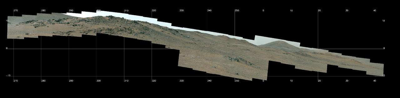
NASA's Perseverance Mars Rover used its Mastcam-Z camera system to capture this panorama of a location nicknamed "Pico Turquino Hills" on Oct. 22, 2024, the 1,306th Martian day, or sol, of the mission. This area is located on the rim of Jezero Crater. Perseverance landed on the crater's floor on Feb. 18, 2021, and has been steadily working its way up and out of the crater since August 2024. The rocks in Pico Turquino Hills are among the oldest yet found by Perseverance, forming in a different geologic era than almost everything the rover has seen before. They're likely part of the original surface that existed before Jezero Crater's formation by a massive asteroid about 3.9 billion years ago. The rocks here are mostly made up of volcanic minerals like olivine, plagioclase, and pyroxene. In the far-right corner of the panorama is a field of white cobbles. This represents the first time Perseverance has encountered pure quartz rock, which may have been created by a hydrothermal system like hot springs – an environment life could have survived in, if any existed on the Red Planet billions of years ago. Arizona State University leads the operations of the Mastcam-Z instrument, working in collaboration with Malin Space Science Systems in San Diego, on the design, fabrication, testing, and operation of the cameras, and in collaboration with the Niels Bohr Institute of the University of Copenhagen on the design, fabrication, and testing of the calibration targets. A key objective for Perseverance's mission on Mars is astrobiology, including the search for signs of ancient microbial life. The rover will characterize the planet's geology and past climate, pave the way for human exploration of the Red Planet, and be the first mission to collect and cache Martian rock and regolith (broken rock and dust). Subsequent NASA missions, in cooperation with ESA (European Space Agency), would send spacecraft to Mars to collect these sealed samples from the surface and return them to Earth for in-depth analysis. The Mars 2020 Perseverance mission is part of NASA's Moon to Mars exploration approach, which includes Artemis missions to the Moon that will help prepare for human exploration of the Red Planet. https://photojournal.jpl.nasa.gov/catalog/PIA26473
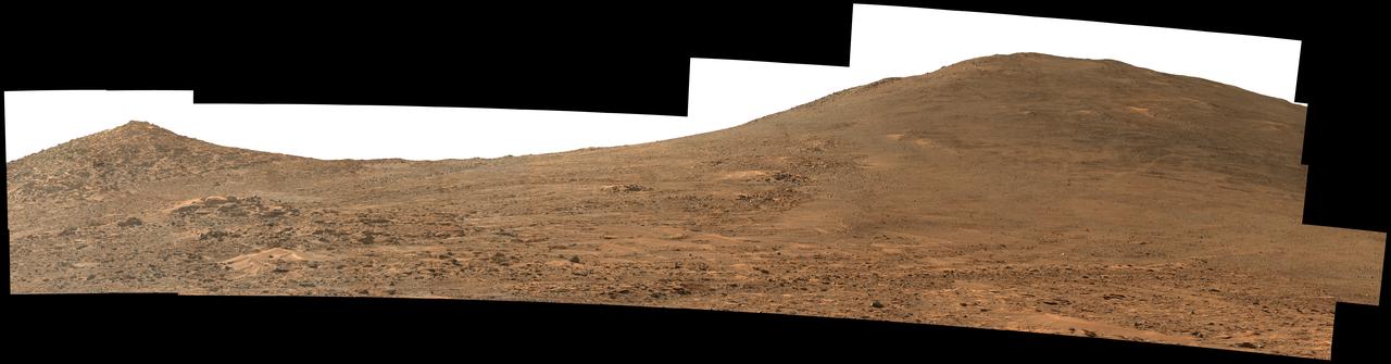
NASA's Perseverance Mars rover used its Mastcam-Z instrument to capture this view looking south toward the rim of Jezero Crater. The panorama, which encompasses 80 degrees, is made up of 59 individual images. They were captured on Aug. 4, 2024, the 1,229th Martian day, or sol, of the mission, and stitched together after being sent back to Earth. The color has been enhanced to bring out subtle details. "Dox Castle," a region the Perseverance science team wants to visit during the rover's climb up the crater rim, is about a half-mile (740 meters) away, on the left side of the hill at right. After the exploration of Dox Castle is complete, the rover will continue its climb up the crater rim, taking a route somewhere in between the two hills. Arizona State University leads the operations of the Mastcam-Z instrument, working in collaboration with Malin Space Science Systems in San Diego, on the design, fabrication, testing, and operation of the cameras, and in collaboration with the Niels Bohr Institute of the University of Copenhagen on the design, fabrication, and testing of the calibration targets. A key objective for Perseverance's mission on Mars is astrobiology, including the search for signs of ancient microbial life. The rover will characterize the planet's geology and past climate, pave the way for human exploration of the Red Planet, and be the first mission to collect and cache Martian rock and regolith (broken rock and dust). https://photojournal.jpl.nasa.gov/catalog/PIA26373

This annotated image was taken by a parachute-up-look camera aboard the protective back shell of NASA's Perseverance rover during its descent toward Mars' Jezero Crater on February 18, 2021. Using binary code, two messages have been encoded in the neutral white and international-orange parachute gores (the sections that make up the canopy's hemispherical shape). The inner portion spells out "DARE MIGHTY THINGS," with each word located on its own ring of gores. The outer band of the canopy provides GPS coordinates for NASA's Jet Propulsion Laboratory in Southern California, where the rover was built and the project is managed. Mars 2020 Perseverance Systems Engineer Ian Clark designed the binary code pattern. The saying is JPL's motto and is an abridgement of a quote from Teddy Roosevelt's "Strenuous Life" speech: "Far better is it to dare mighty things, to win glorious triumphs, even though checkered by failure ... than to rank with those poor spirits who neither enjoy nor suffer much, because they live in a gray twilight that knows not victory nor defeat." https://photojournal.jpl.nasa.gov/catalog/PIA24431
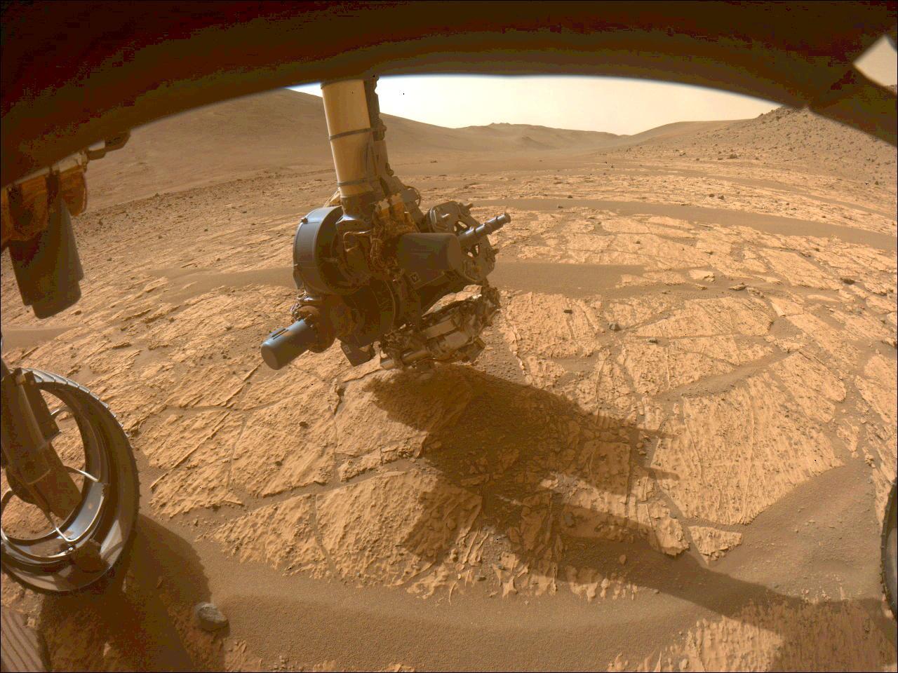
This image shows the WATSON camera aboard NASA's Perseverance Mars rover gathering data on the "Walhalla Glades" abrasion patch. It was taken in the "Bright Angel" region of Jezero Crater by one of the rover's front hazard avoidance cameras on June 14, 2024, the 1,180th Martian day, or sol, of the mission. WATSON (Wide Angle Topographic Sensor for Operations and eNgineering) is located on the SHERLOC (Scanning Habitable Environments with Raman and Luminescence for Organics and Chemicals) instrument at the end of Perseverance's long robotic arm. In this image, SHERLOC is at the bottom of the turret. The WATSON camera head is closest to the surface, and SHERLOC's Autofocus and Context Imager (another camera) is to the right, closer to the drill. A key objective for Perseverance's mission on Mars is astrobiology, including the search for signs of ancient microbial life. The rover is also characterizing the planet's geology and past climate, which paves the way for human exploration of the Red Planet. JPL, which is managed for NASA by Caltech in Pasadena, California, built and manages operations of the Perseverance rover. https://photojournal.jpl.nasa.gov/catalog/PIA26320
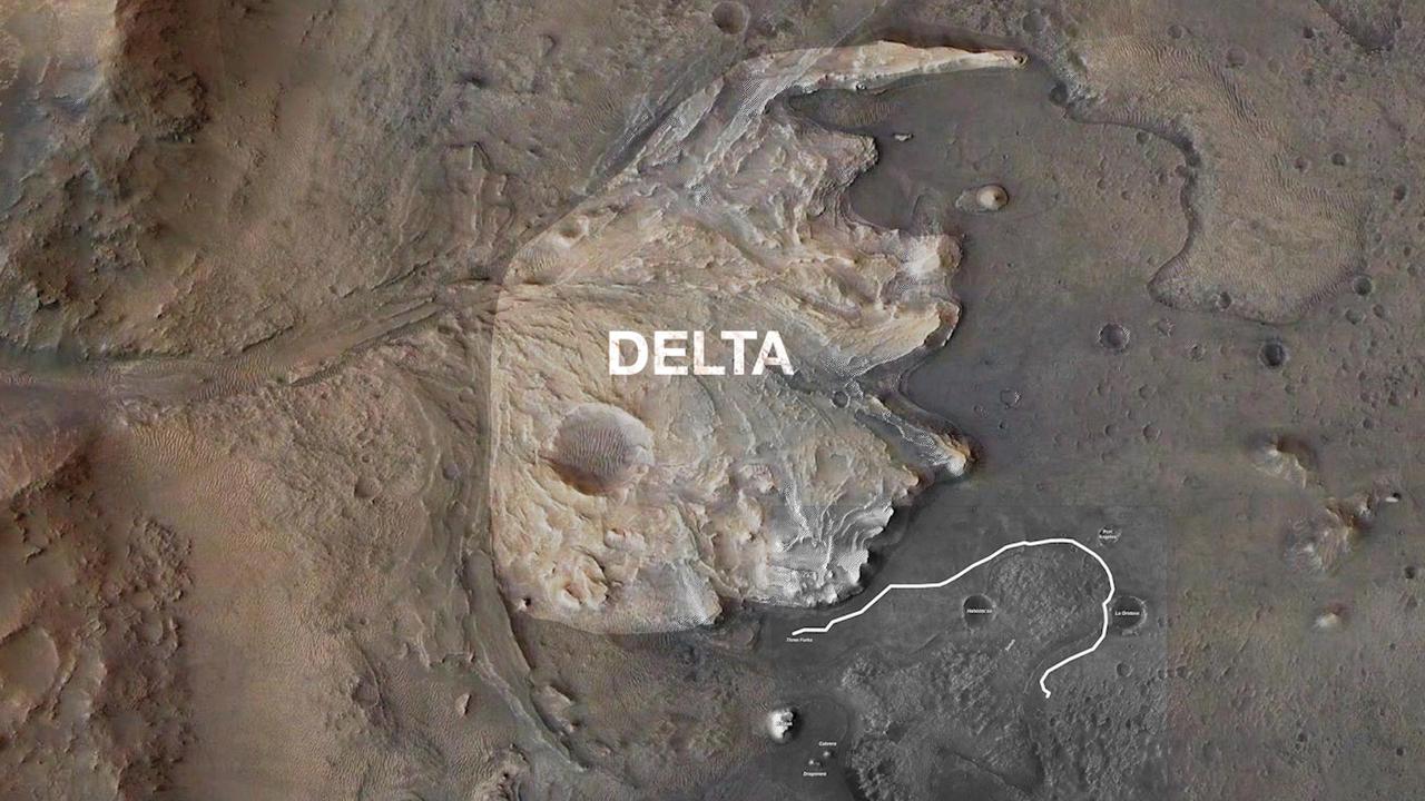
NASA's Perseverance Mars rover will follow the proposed route to Jezero Crater's delta shown in this annotated animated GIF. The delta is one the most important locations the rover will visit as it seeks signs of ancient life on Mars. This map includes data from the HiRISE camera aboard NASA's Mars Reconnaissance Orbiter. A key objective for Perseverance's mission on Mars is astrobiology, including the search for signs of ancient microbial life. The rover will characterize the planet's geology and past climate, pave the way for human exploration of the Red Planet, and be the first mission to collect and cache Martian rock and regolith (broken rock and dust). Subsequent NASA missions, in cooperation with ESA (European Space Agency), would send spacecraft to Mars to collect these sealed samples from the surface and return them to Earth for in-depth analysis. The Mars 2020 Perseverance mission is part of NASA's Moon to Mars exploration approach, which includes Artemis missions to the Moon that will help prepare for human exploration of the Red Planet. Movie available at