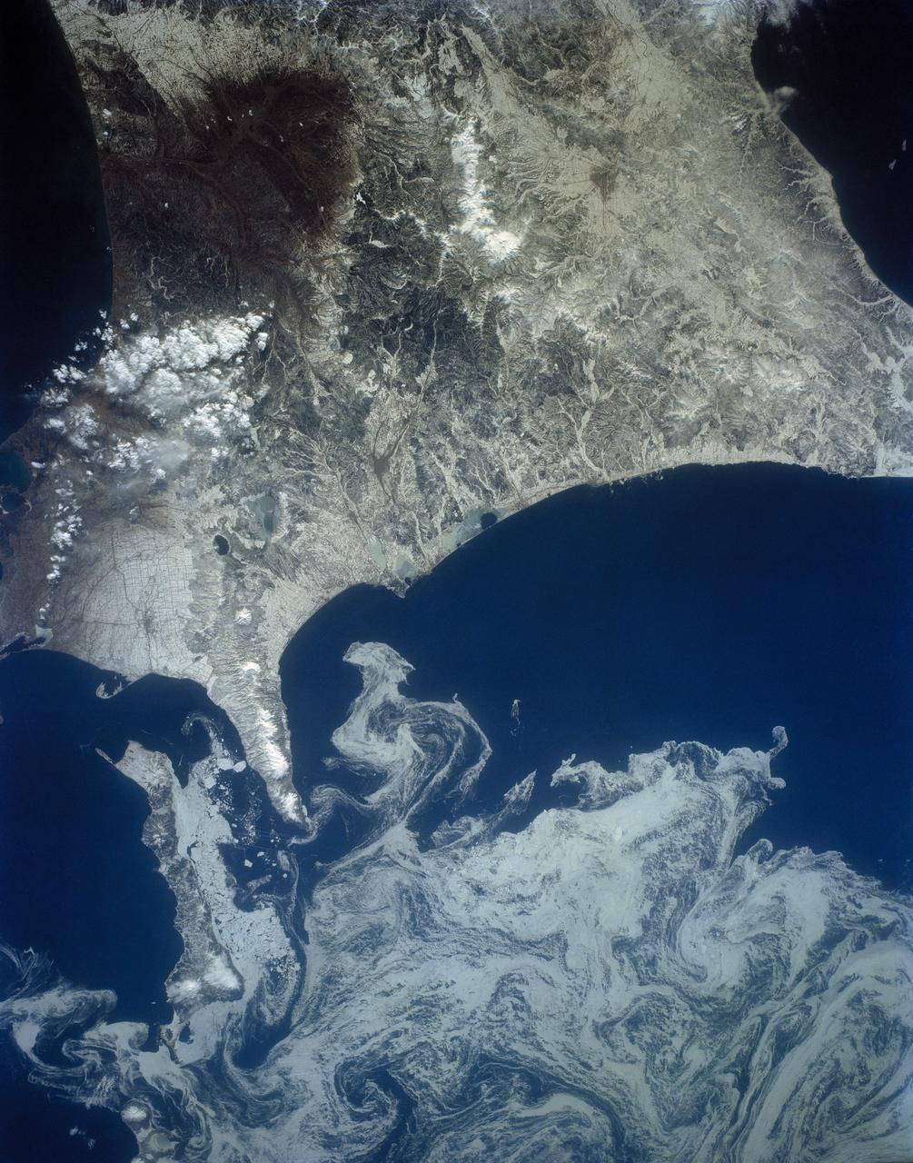
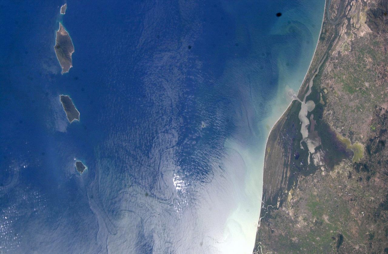
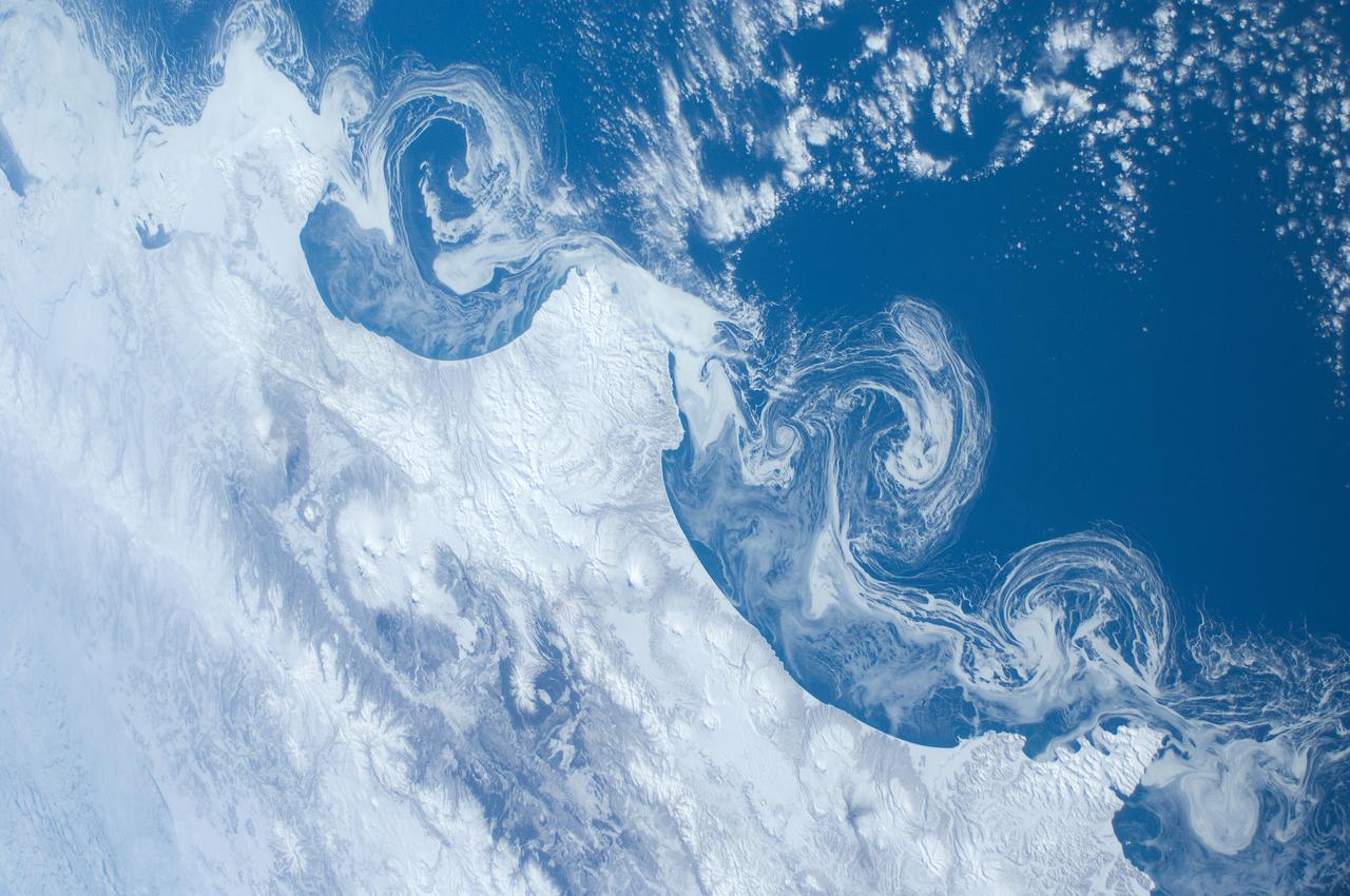
The northeast coast of Hokkaido and Kunashir Island, Japan (44.0N, 143.0E) are seen bordered by drifting sea ice. The sea ice has formed a complex pattern of eddies in response to surface water currents and winds. Photos of this kind aid researchers in describing local ocean current patterns and the effects of wind speed and direction on the drift of surface material, such as ice floes or oil. Kunashir is the southernmost of the Kuril Islands.

This large tabular iceberg, broken off from the Antarctic Ice Sheet, was spotted in the South Atlantic Ocean (57.0S, 57.0W) southeast of the tip of South America as it was slowly being moved north and east by wind, current and tidal influences. This type of iceberg, never to be seen in the northern hemisphere, is typical for Antarctica. Although some such icebergs are as large as 100 km in length, this one measures about 35 by 69 km.

This February 8, 2016 composite image reveals the complex distribution of phytoplankton in one of Earth's eastern boundary upwelling systems — the California Current. Recent work suggests that our warming climate my be increasing the intensity of upwelling in such regions with possible repercussions for the species that comprise those ecosystems. NASA's OceanColor Web is supported by the Ocean Biology Processing Group (OBPG) at NASA's Goddard Space Flight Center. Our responsibilities include the collection, processing, calibration, validation, archive and distribution of ocean-related products from a large number of operational, satellite-based remote-sensing missions providing ocean color, sea surface temperature and sea surface salinity data to the international research community since 1996. Credit: NASA/Goddard/Suomin-NPP/VIIRS <b><a href="http://www.nasa.gov/audience/formedia/features/MP_Photo_Guidelines.html" rel="nofollow">NASA image use policy.</a></b> <b><a href="http://www.nasa.gov/centers/goddard/home/index.html" rel="nofollow">NASA Goddard Space Flight Center</a></b> enables NASA’s mission through four scientific endeavors: Earth Science, Heliophysics, Solar System Exploration, and Astrophysics. Goddard plays a leading role in NASA’s accomplishments by contributing compelling scientific knowledge to advance the Agency’s mission. <b>Follow us on <a href="http://twitter.com/NASAGoddardPix" rel="nofollow">Twitter</a></b> <b>Like us on <a href="http://www.facebook.com/pages/Greenbelt-MD/NASA-Goddard/395013845897?ref=tsd" rel="nofollow">Facebook</a></b> <b>Find us on <a href="http://instagrid.me/nasagoddard/?vm=grid" rel="nofollow">Instagram</a></b>
SL4-137-3655 (16 Dec. 1973) --- An island wake produced by the Antipodes Islands in the ocean current south of New Zealand is seen in this photograph taken from the Skylab space station in Earth orbit. A Skylab 4 crewmen took the picture with a hand-held 70mm Hasselblad camera. The bow wave pattern is quite evident and can be used to determine the current speed from the angle of the bow wave if the propagation speed of the surface wave is known. Also, evident is the darker band extending downstream from the island tens of miles. This is the actual wake of the island. The existence of water color differences from within to outside a turbulent island wake may indicate a temperature difference, with cooler water being stirred to the surface in the wake. This temperature difference could be used to drive a thermo-electric type generator to reduce small islands' dependence on imported oil for power generation. Photo credit: NASA

STS054-72-056 (13-19 Jan 1993) --- A ship wake in the Bay of Bengal is noticeable in this 70mm frame. The sun glint pattern on the ocean reveals many patterns of sea surface roughness related to currents, waves, wind roughening, and biology that and are not apparent when the ocean is viewed away from the Sun's reflection. In this view of the Bay of Bengal, southeast of Madras, India, sun glint highlights convergence zones between ocean currents (bright, linear features), a eddy, and the wake of a ship. In several locations where the ship has passed areas of current shear, the ship wake is distorted, indicating the relative current direction.
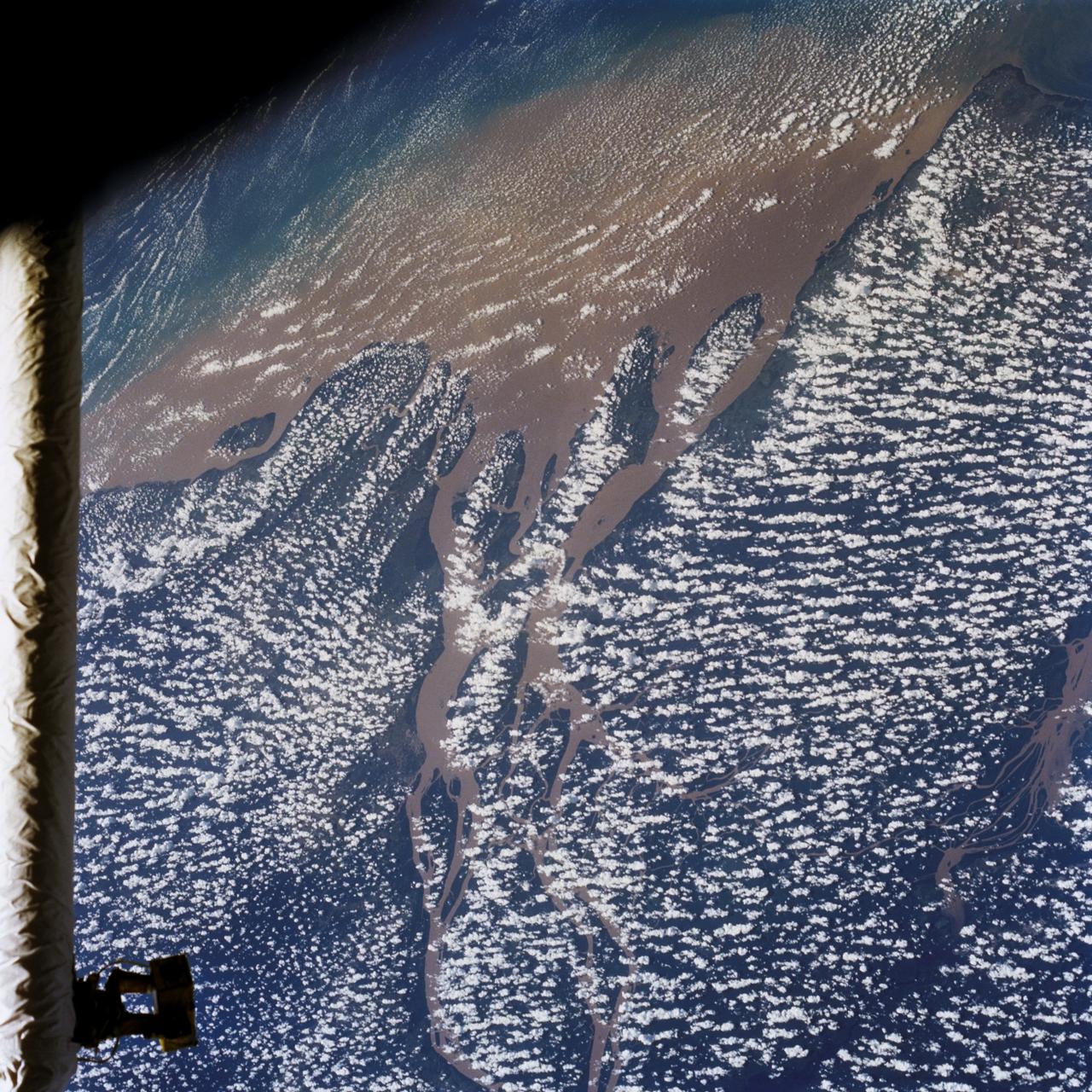
STS046-80-009 (31 July-8 Aug. 1992) --- A view of the mouth of the Amazon River and the Amazon Delta shows a large sediment plume expanding outward into the Atlantic Ocean. The sediment plume can be seen hugging the coast north of the Delta. This is caused by the west-northwest flowing Guyana Current. The large island of Marajo is partially visible through the clouds.
The northern portion of the Gulf of Mexico Loop Current, shown in red, appears about to detach a large ring of current, creating a separate eddy. An eddy is a large, warm, clockwise-spinning vortex of water -- the ocean version of a cyclone.
STS044-79-077 (24 Nov.-1 Dec. 1991) --- This photograph, captured from the Earth-orbiting Space Shuttle Atlantis, shows sunglint pattern in the western tropical Indian Ocean. Several large internal waves reflect around a shallow area on the sea floor. NASA scientists studying the STS-44 photography believe the shallow area to be a sediment (a submerged mountain) on top of the Mascarene Plateau, located northeast of Madagascar at approximately 5.6 degrees south latitude and 55.7 degrees east longitude. Internal waves are similar to surface ocean waves, except that they travel inside the water column along the boundary between water layers of different density. At the surface, their passage is marked on the sea surface by bands of smooth and rough water. These bands appear in the sunglint pattern as areas of brighter or darker water. NASA scientists point out that, when the waves encounter an obstacle, such as a near-surface seamount, they bend or refract around the obstacle in the same manner as surface waves bend around an island or headland.
STS054-95-042 (13-19 Jan 1993) --- The Equatorial Pacific Ocean is represented in this 70mm view. The international oceanographic research community is presently conducting a program called Joint Global Ocean Flux Study (JGOFS) to study the global ocean carbon budget. A considerable amount of effort within this program is presently being focused on the Equatorial Pacific Ocean because of the high annual average biological productivity. The high productivity is the result of nearly constant easterly winds causing cool, nutrient-rich water to well up at the equator. In this view of the sun glint pattern was photographed at about 2 degrees north latitude, 103 degrees west longitude, as the Space Shuttle passed over the Equatorial Pacific. The long narrow line is the equatorial front, which defines the boundary between warm surface equatorial water and cool, recently upwelled water. Such features are of interest to the JGOFS researchers and it is anticipated that photographs such as this will benefit the JGOFS program.
STS040-614-047 (5-14 June 1991) --- This image is of the Norfolk, Virginia -- Southern Delmarva Peninsula Southern Chesapeake Bay Area as seen in sunlight. The exposure is adjusted to emphasize the water patterns present. The outgoing tide generates considerable turbulence as it passes through the mouth of the bay. This is displayed by differences in reflective properties of the water surface due to differences in slope and turbidity. Ship wakes and the wakes of subsurface structures are seen clearly. The bridge tunnel system linking Norfolk with the peninsula and its effect on the system is quite apparent. Sunglint images over land areas were also acquired which emphasize land-water boundaries as demonstrated here in the small Delmarva inlets as a tool for wetland mapping, and river, lake and even pond description. During the first few days of the STS-40 mission the Eastern Seaboard of the United States was free of clouds and haze providing excellent photography of many of the major cities and the countryside of that area as well as the Gulf Stream.
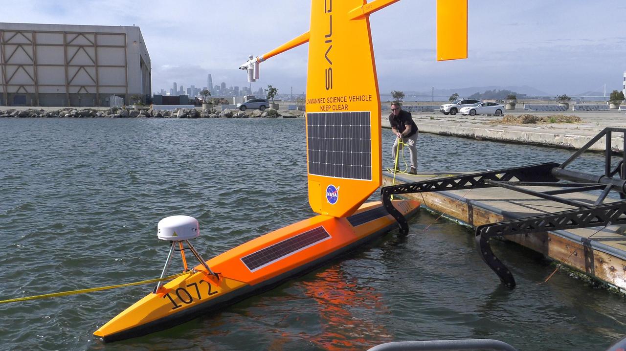
As part of NASA's Sub-Mesoscale Ocean Dynamics Experiment (S-MODE) field campaign, several Saildrones like the one pictured here were launched from San Francisco Bay. The Saildrones were part of a fleet of autonomous marine research vessels designed to measure a vast array of factors such as ocean currents, wind speed and direction, air and water temperature, salinity, dissolved oxygen, and chlorophyll content. S-MODE is a NASA Earth mission to use newly developed in-situ and remote-sensing techniques to look at small-scale ocean whirlpools, eddies, and currents. The observations could help scientists better understand how these dynamics drive the give-and-take of material and energy between the ocean and atmosphere and, ultimately, help shape Earth's climate. More information about S-MODE is at https://espo.nasa.gov/s-mode/content/S-MODE https://photojournal.jpl.nasa.gov/catalog/PIA25523
SL4-137-3632 (February 1974) --- A photograph taken from the Skylab space station in Earth orbit illustrating an atmospheric wave pattern by the affect of a small mountainous island on wind currents. Various patterns can be seen downwind of small islands. Often a Von Karmon vortex can be seen which appears as a spiral pattern. Multiple vortices have been photographed on previous missions. This photograph illustrates a "bow wave" pattern which extends for hundreds of miles downwind from the island. The island itself is often clear when a wave pattern is formed downstream. This particular pattern is very symmetrical. These wave patterns are most common in the South Pacific. This picture was taken by a Skylab 4 crewmen using a hand-held 70mm Hasselblad camera. Photo credit: NASA
STS007-05-245 (18-24 June 1983) --- A rare view of internal waves in the South China Sea. Several different series of internal waves are represented in the 70mm frame, exposed with a handheld camera by members of the STS-7 astronaut crew aboard the Earth-orbiting Challenger. The land area visible in the lower left is part of the large island of Hainan, China.
SL4-137-3721 (February 1974) --- Plankton blooms and color variations in the Falkland Current east of the Argentina coast in the South Atlantic Ocean as seen from the Skylab space station in Earth orbit. This picture was taken by one of the Skylab 4 crewmen using a hand-held 70mm Hasselblad camera. The Skylab 4 crew made many observations of the Falkland Current and related phenomena. This current flows north and northeastward along the Argentine coast near 40 degree south latitude where it meets the Brazil Current and the two swing eastward. The study of such photographs as this one can add significantly to our knowledge and understanding of the oceans. Photo credit: NASA

NAS Facility Hyperwall 2 visit and tour: HQ Review Committee on Facility & Real Property. Showing on Hyperwall Ocean current temperatures.

This spectacular north looking view of south Greenland (62.0N, 46.0W) shows numerous indentations along the coastline, many of which contain small settlements. These indentations are fiords carved by glaciers of the last ice age. Even today, ice in the center of Greenland is as much as 10,000 ft. thick and great rivers of ice continuously flow toward the sea, where they melt or break off as icebergs - some of which may be seen floating offshore.
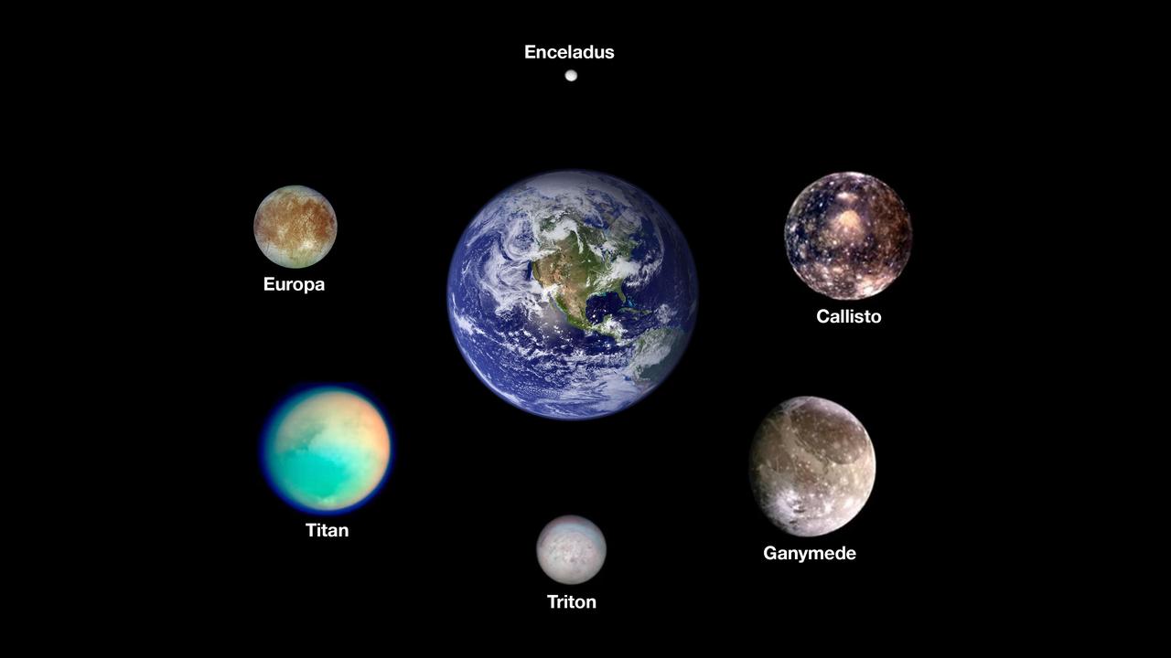
Scientists think six icy moons in our solar system may currently host oceans of liquid water beneath their outer surfaces. Arranged around Earth are images from NASA spacecraft of, clockwise from the top, Saturn's moon Enceladus, Jupiter's moons Callisto and Ganymede, Neptune's moon Triton, Saturn's moon Titan, and Jupiter's moon Europa, the target of NASA's Europa Clipper mission. The worlds here are shown to scale. The images of the Saturnian moons were taken by NASA's Cassini mission. The images of the Jovian moons were taken by NASA's Galileo mission. The image of Triton was taken by NASA's Voyager 2 mission. The image of Earth was stitched together using months of satellite-based observations, mostly using data from the Moderate Resolution Imaging Spectroradiometer (MODIS) on NASA's Terra satellite. https://photojournal.jpl.nasa.gov/catalog/PIA26103
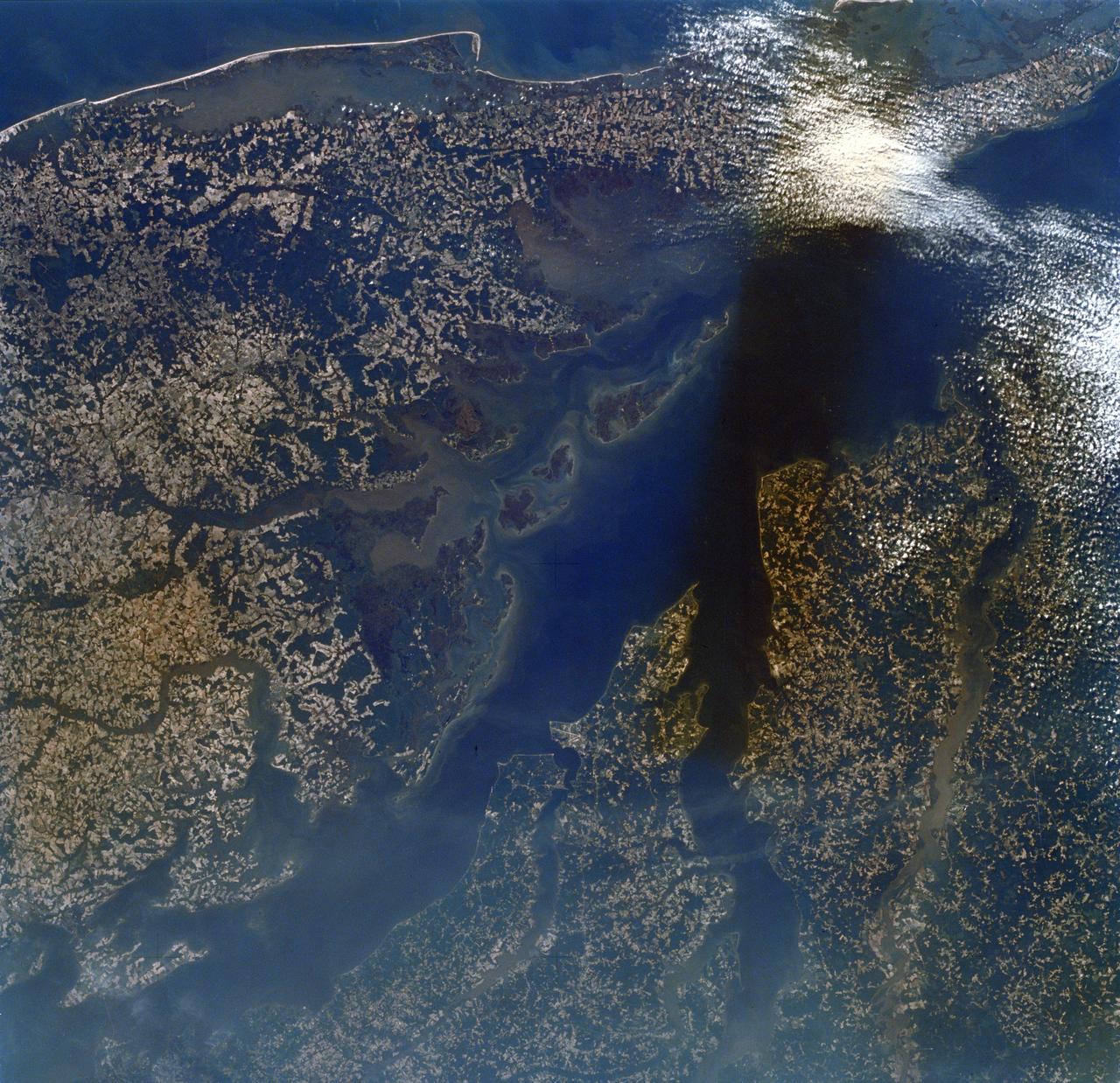
SL2-16-174 (22 June 1973) --- Norfolk and the lower Chesapeake Bay, VA (37.5N, 75.5W) at the interface of the Atlantic Ocean can be seen to be a mixture of complex currents. Outgoing tides from the bay generate considerable turbulence as they encounter coastal currents and can be observed by the sediment plumes stirred up as a result of current dynamics. Smooth flowing water has less sediment and appears darker. Turbulent water has lots of sediment and appears lighter in color. Photo credit: NASA
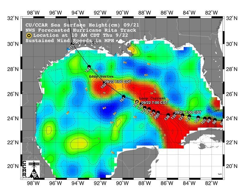
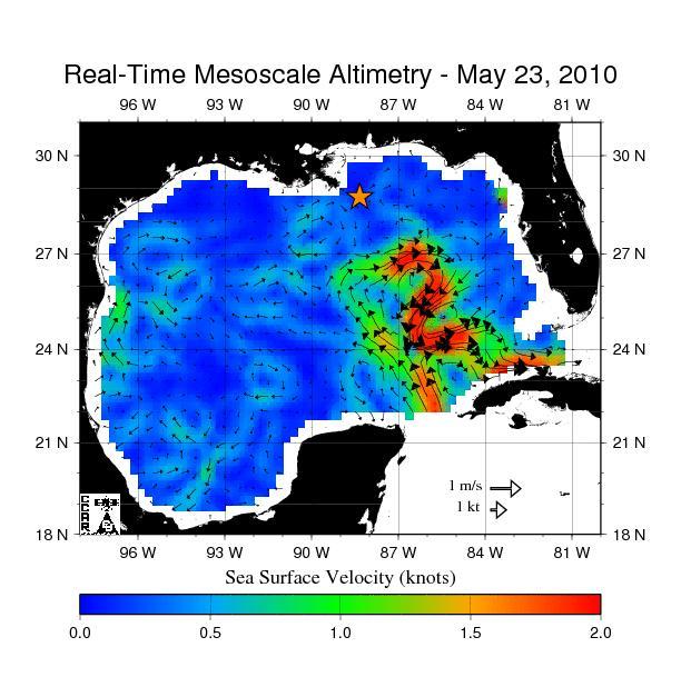
This sea surface height map of the Gulf of Mexico, with the Florida peninsula on the right and the Texas-Mexico Gulf Coast on the left, is based on altimeter data from four satellites including NASA’s Topex/Poseidon and Jason. Red indicates a strong circulation of much warmer waters, which can feed energy to a hurricane. This area stands 35 to 60 centimeters (about 13 to 23 inches) higher than the surrounding waters of the Gulf. The actual track of a hurricane is primarily dependent upon steering winds, which are forecasted through the use of atmospheric models. However, the interaction of the hurricane with the upper ocean is the primary source of energy for the storm. Hurricane intensity is therefore greatly affected by the upper ocean temperature structure and can exhibit explosive growth over warm ocean currents and eddies. Eddies are currents of water that run contrary to the direction of the main current. According to the forecasted track through the Gulf of Mexico, Hurricane Rita will continue crossing the warm waters of a Gulf of Mexico circulation feature called the Loop Current and then pass near a warm-water eddy called the Eddy Vortex, located in the north central Gulf, south of Louisiana. http://photojournal.jpl.nasa.gov/catalog/PIA06427
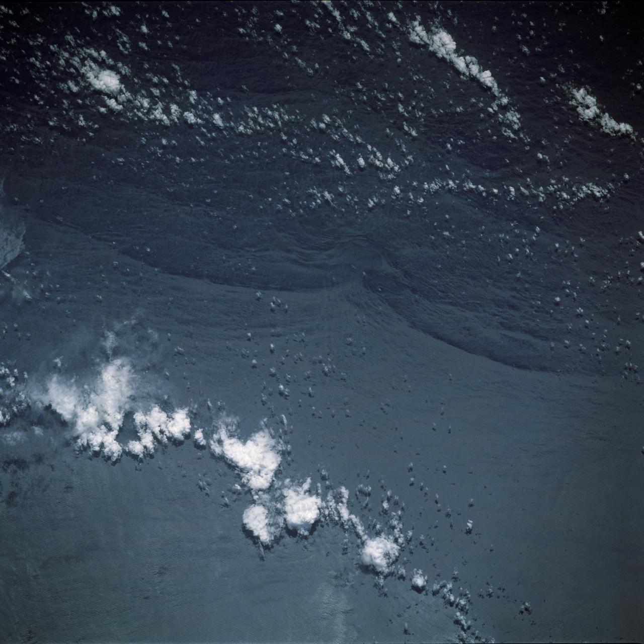
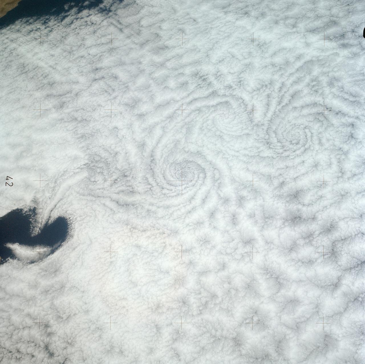
SL4-137-3608 (14 Dec. 1973) --- A view of cold water eddies in the Falkland Current off the South Atlantic coast of southern Argentina as seen from the Skylab space station in Earth orbit. This picture was taken by one of the Skylab 4 crewmen using a hand-held 70mm Hasselblad camera. This land area (left corner) extends south along the coast from Puerto Deseado (center left border) for about 50 miles. Within the ocean, several light blue areas are visible and represent the occurrence of plankton with the Falkland Current. Over the ocean, the cold water eddies are identified by the circular cloud-free areas within the cloud street pattern and bordered by cumulus cloud buildup (white). The cloud streets indicate the wind is from the southwest and do not form over eddies because energy form the atmosphere is absorbed by the cold ocean water. On the downwind side of the eddies, cumulus clouds tend to form as the cold moist air flows over the warmer water. Similar cloud and eddy features have been observed by the Skylab 4 crewmen in the Yucatan Current off Yucatan Peninsula and in some parts of the South Pacific. Studies are underway by Dr. George Maul, NOAA, and Dr. Robert Stevenson, ONR, to determine the significance of the cold water eddies to ocean dynamics. Photo credit: NASA
The southernmost tip of Africa is marked by the Cape Agulhas lighthouse. The warm Atlantic Agulhas current meets the cold water Indian Ocean Benguela current, creating treacherous seas that have claimed many ships over the last 450 years. The image covers an area of 22.5 by 41.1 kilometers, was acquired September 27, 2006, and is located at 34.8 degrees south, 20 degrees east. http://photojournal.jpl.nasa.gov/catalog/PIA21014
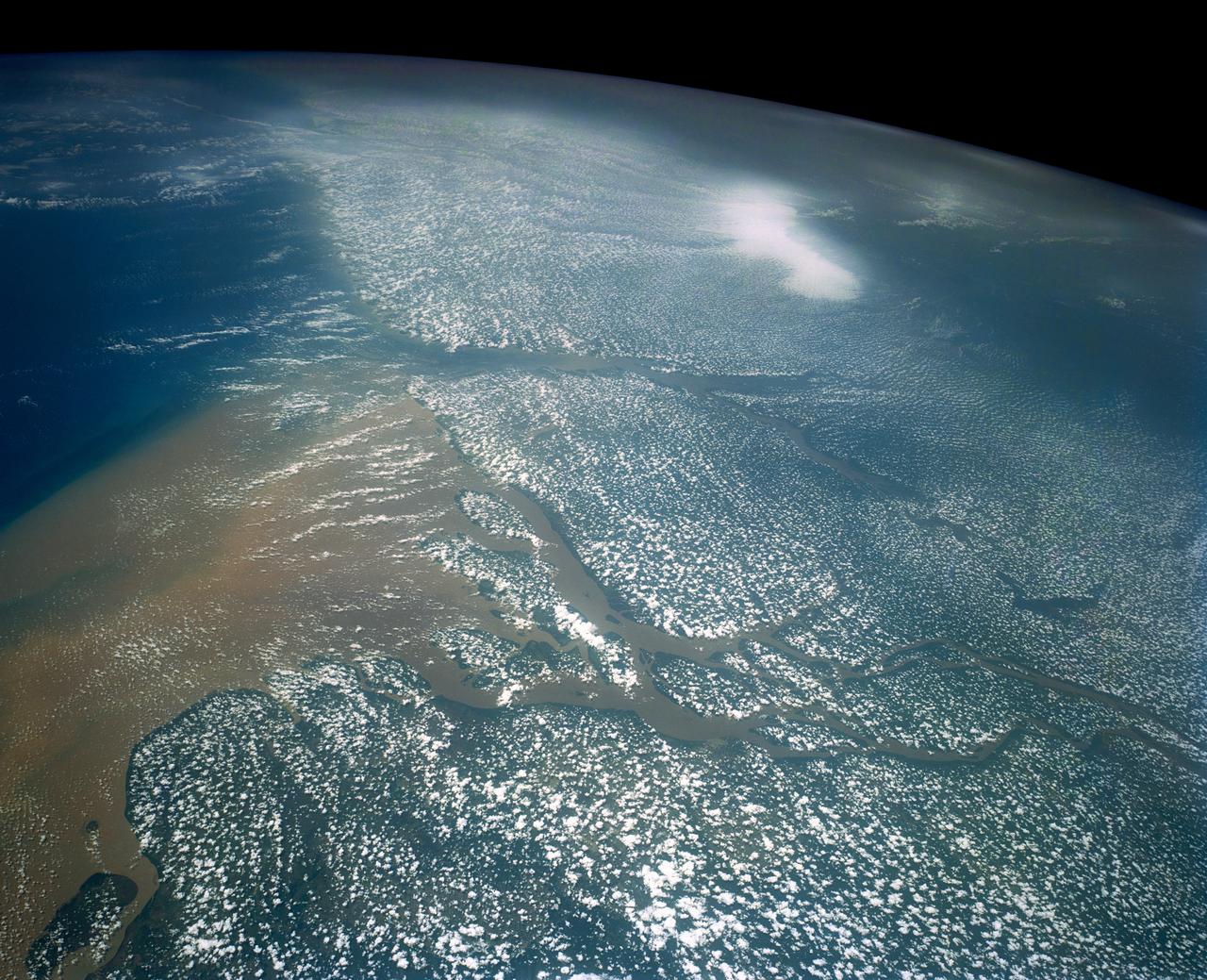
Huge sediment loads from the interior of the country flow through the Mouths of the Amazon River, Brazil (0.5S, 50.0W). The river current carries hundreds of tons of sediment through the multiple outlets of the great river over 100 miles from shore before it is carried northward by oceanic currents. The characteristic "fair weather cumulus" pattern of low clouds over the land but not over water may be observed in this scene.

Swift currents flow through the Strait of Gibraltar, producing complicated patterns in the surface waters. Some of those patterns are highlighted in the sunglint in this photograph. The Mediterranian Sea is on the upper right, the Atlantic Ocean in in the lower left. Few features can be seen on the Mediterranian side, but current shears (straight lines coming off Spain), several sets of internal waves (impinging on the Spanish continental shelf) and ship wakes can be seen on the Atlantic side, west of Cadiz. Both Tangier and Cadiz show up in the sunglint as well.

NASA astronaut and Expedition 64 Flight Engineer Victor Glover works with the FLUIDICS experiment, which observes how liquids move in microgravity. Understanding the underlying physics of how liquids move in space could improve spacecraft fuel economy and our knowledge of Earth’s ocean currents.

Damaging heavy rains fell on South Carolina in the southeastern United States at the beginning of October 2015. Much of that water had, by mid October, flowed into the Atlantic Ocean bringing with it heavy loads of sediment, nutrients, and dissolved organic material. The above VIIRS image shows the runoff as it interacts with ocean currents on October 15, 2015. Credit: NASA/Goddard/SuomiNPP/VIIRS via NASA's OceanColor

This artist's rendering showing a cutaway view into the interior of Saturn's moon Enceladus. NASA's Cassini spacecraft discovered the moon has a global ocean and likely hydrothermal activity. A plume of ice particles, water vapor and organic molecules sprays from fractures in the moon's south polar region. This graphic is an update to a previously published version (see PIA19656) that did not show the ice and ocean layers to scale. The revised graphic more accurately represents scientists' current understanding of the thickness of the layers. http://photojournal.jpl.nasa.gov/catalog/PIA20013
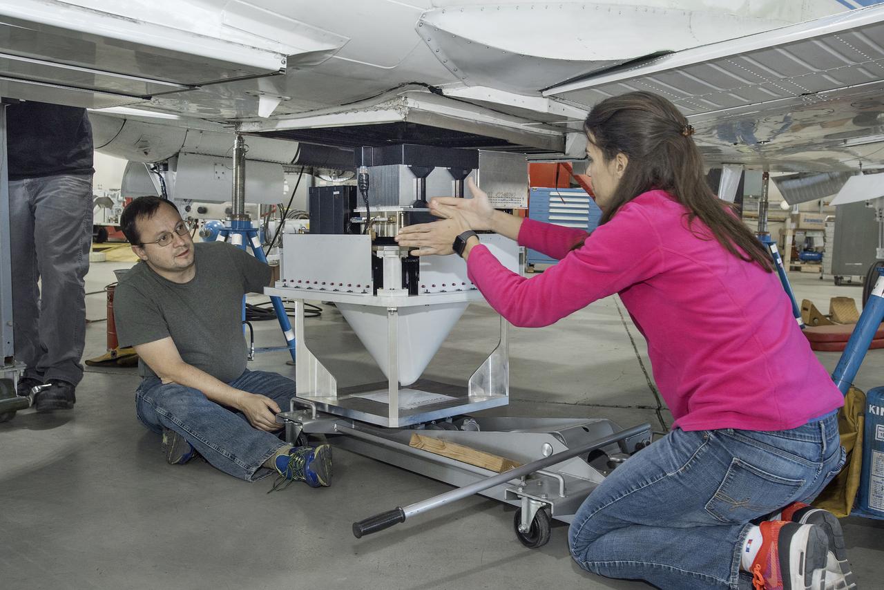
Engineers Raquel Rodriguez Monje and Fabien Nicaise discuss placement of the DopplerScatt radar instrument on the NASA B200 before its final installation onto the aircraft’s fuselage.
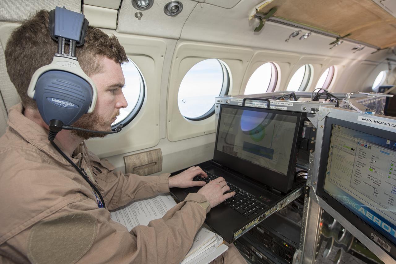
Radar operator Alexander Winteer monitors incoming wind data from the DopplerScatt radar instrument during a science flight off the California Coast on March 5, 2018.

NASA’s B200 taking off for an eight-hour science flight on March 5. Located on the center of the aircraft’s fuselage is the DopplerScatt radar instrument, developed by NASA’s Jet Propulsion Laboratory in California.
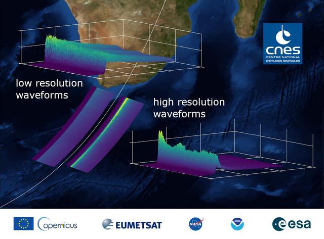
This graphic, released on Dec. 10, 2020, shows the basic radar measurements, called waveforms, collected by the instrument that monitors sea level on the Sentinel-6 Michael Freilich satellite, which launched Nov. 21, 2020. The instrument, called an altimeter, works by bouncing a radar signal off the ocean surface and measuring how long it takes to go out and return. The higher-resolution waveforms focus on a smaller area of the ocean than the lower-resolution waveforms, allowing researchers to resolve smaller ocean features such as currents closer to the coast. The waveform provides information not only on sea level, but also on wave height and wind speed. https://photojournal.jpl.nasa.gov/catalog/PIA24136
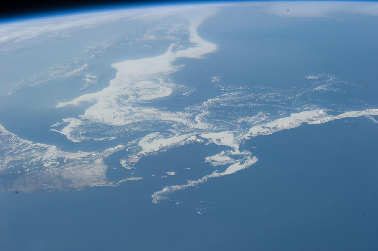
ISS039-E-11773 (14 April 2014) --- Photographed with a camera equipped with an 80mm lens from the International Space Station, patterns of sea ice in the Sea of Okhotsk reveal the dynamics of ocean currents that could otherwise only be seen in sunglint. In this Expedition 39 photo, one can see nearly 1,000 kilometers (600 miles) of the East Sakhalin Current, which is carrying winter ice south toward Japan’s Hokkaido Island. The current is marked by the narrow corridor of dense ice that hugs the coast of Russia’s Sakhalin Island. As it approaches Hokkaido, the ice patterns show a series of eddies and swirls. The East Sakhalin Current wanes in summer when the Soya Current begins to enter the Sea of Okhotsk. This inrush of summer water starts in April and, according to NASA scientists, probably expresses itself in this image as ice pattern to the east above Hokkaido. The Sakhalin current turns east and transports ice toward the Kuril Island chain. Some ice can spill through gaps in the islands, where it is swept southwest by the Kuril Current (lower right).

This animation, created in 2012, shows the increasing clarity and detail of measurements of sea height made by successive satellite altimeters launched by NASA and other agencies over the past four decades, concluding with data at the resolution possible with the Surface Water and Ocean Topography (SWOT) satellite, expected to launch in December 2022. Each new spacecraft has been able to obtain higher-resolution observations than its predecessors. Sea height is key to understanding how much, and how fast, the oceans are rising in a warming climate. The animation starts with Seasat, launched in 1978 as one of the NASA's earliest Earth-observing satellites, then moves to Geosat, a U.S. Navy spacecraft launched in 1985, and on to ERS-1, TOPEX/Poseidon, ERS-2, Jason-1, Envisat, and Jason-2. Since the end of the time period shown in the animation, subsequent satellites have continued measuring sea height, creating an ongoing, decadeslong record. In March 2022, Sentinel-6 Michael Freilich, a joint U.S.-European mission, became the official reference satellite for global sea level measurements. SWOT will be latest spacecraft to observe ocean heights from Earth orbit. Its measurements will provide unprecedented insights into the activity of small-scale currents and their impact on climate change. Researchers believe small-scale currents, which are less than 60 miles (100 kilometers) in size, have a significant influence on the ocean's ability to absorb atmospheric heat and carbon and thereby moderate global temperature change. To measure these currents, SWOT will employ the Ka-band Radar Interferometer (KaRIn), a new technology developed at NASA's Jet Propulsion Laboratory in Southern California that will offer even greater spatial resolution than previous instruments that studied the ocean. SWOT will survey the water in Earth's lakes, rivers, reservoirs, and the ocean. The satellite will cover the planet's surface twice every 21 days and has a prime mission of three years. It was jointly developed by NASA and France's Centre National d'Études Spatiales (CNES), with contributions from the Canadian Space Agency (CSA) and the UK Space Agency. JPL, a division of Caltech in Southern California, manages the U.S. portion of the mission for NASA. Animation available at https://photojournal.jpl.nasa.gov/catalog/PIA25561
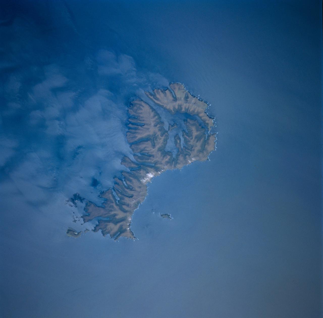
STS089-743-004 (22-31 Jan. 1998) --- This picture showing Auckland Island, New Zealand was photographed with a 70mm handheld camera from the Earth-orbiting space shuttle Endeavour. A spectacular occurrence of internal waves in the ocean is visible in the wake of the island. These waves can be generated by currents or, in some cases, wind across the island. In this case, the observation was that these waves were visible after the sunglint disappeared, suggesting current generated effects. If so, the circum-polar current that moves west-east around Antarctica would generate the scalloped appearance in the water east of the island. There is characteristically very little surface expression to these waves so they would not be noticed by a ship in this region. Fundamental processes of oceanic circulation and interaction are poorly understood. These shots help oceanographers model the dynamics of the open ocean and work out mixing models for ocean layer and ocean-air interaction (important for modeling CO2 budget, for example). The long linear valleys and bays have been excavated by glaciers cutting into this long-extinct volcano. This island is located on the submerged Campbell Plateau, which is an area almost as large as the exposed land of South Island, New Zealand. Scientists report that the plateau was submerged when New Zealand, Antarctica and Australia separated "around 75 million years ago." This could be viewed as one of the tallest mountains on the plateau. Usually the weather in this area is bad so this photo opportunity was considered a "great catch." Photo credit: NASA
STS062-86-196 (4-18 March 1994) --- This photo depicts many of the types of ocean features seen when illuminated by sunglint. These features include a shear line, bilge dump, currents and ship wakes. Winds, currents and oils effect the smoothness of the surface of the water. The oils smooth the water which reflect the sun more than the rougher surround water. This is seen in the bright curved line which is a bilge dump of oily water from a ship. The oils then start to take the form of the currents and in this case are also being blown by the surface winds. The shear line is approximately 240 miles west of Bombay, India. This shear line appears to be a result of two water masses, moving at slightly different speeds, having converged. Ship wakes, such as those in the photo, which cross a shear line, often give us an indication of the relative strenght of a a shear.
iss070e086805 (2/3/2024) --- NASA astronaut Loral O’Hara captured this arctic region of Canada using a handheld digital camera. Sea ice traces ocean currents, creating swirls visible along the coast of Labrador in eastern Canada. According to the National Snow and Ice Data Center, sea ice throughout the Arctic region grew more slowly than usual in January 2024. Monitoring Earth’s climate via space station can provide scientists with more data and information about the planet we call home.

Director's Colloquium; Dr Jonathan Trent, Physical Scientist with NASA Ames Bioengineering Branch presents 'OMEGA and the Future of Aviation Fuels) Abstract: Offshore Membrane Enclosures for Growing Algae (OMEGA) is an innovative approach to growing oil-producing, freshwater algea in off shore enclosures, using municipal wastewater that is currently dumped into the ocean at a rate of >35 billion gals/day.
SL3-121-2371 (July-September 1973) --- A pattern of downstream eddies in the stratocumulus clouds over the Pacific Ocean west of Baja California, as photographed by the crewmen of the second Skylab manned mission (Skylab 3) from the space station cluster in Earth orbit. The clouds, produced by the cold California current running to the south and southwest, are prevented from rising by warm air above them. Photo credit: NASA

STS062-153-226 (4-18 March 1994) --- Though it did not reproduce well, this photo gives scientific information to aid in studying all types of earth's processes. It documents ocean features in the sunglint in the Gulf of California, off the Isla Cerralvo, souther Baja, California. Biological oils collect on the surface and shows current patterns, eddies and ship wakes. The small bright spot on the edge of the eddy is a ship dumping oily water from its bilges. The line in the brighter area is a light wind gust roughening the surface.

Director's Colloquium; Dr Jonathan Trent, Physical Scientist with NASA Ames Bioengineering Branch presents 'OMEGA and the Future of Aviation Fuels) Abstract: Offshore Membrane Enclosures for Growing Algae (OMEGA) is an innovative approach to growing oil-producing, freshwater algea in off shore enclosures, using municipal wastewater that is currently dumped into the ocean at a rate of >35 billion gals/day.

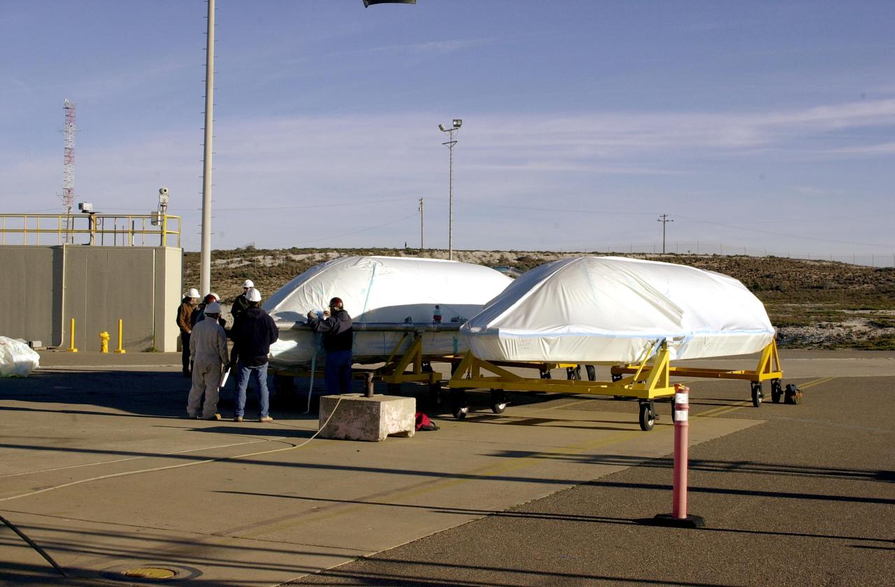
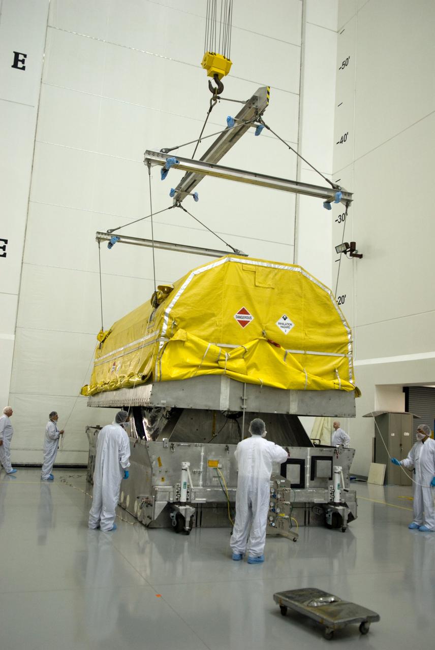
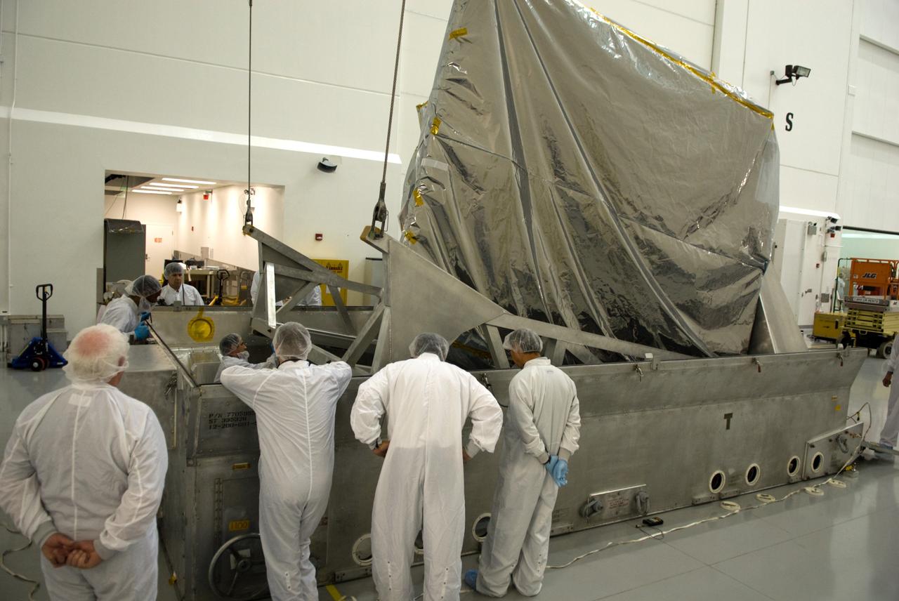
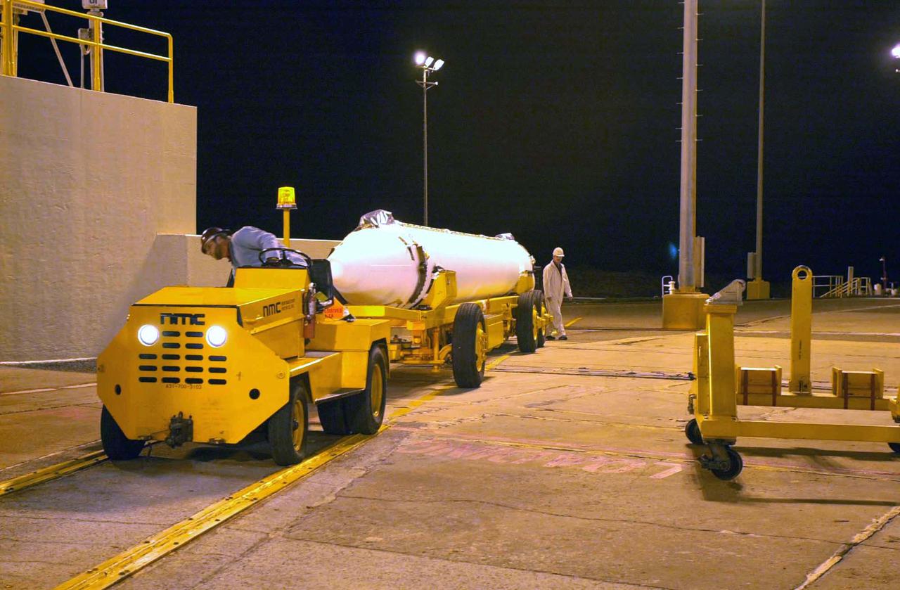
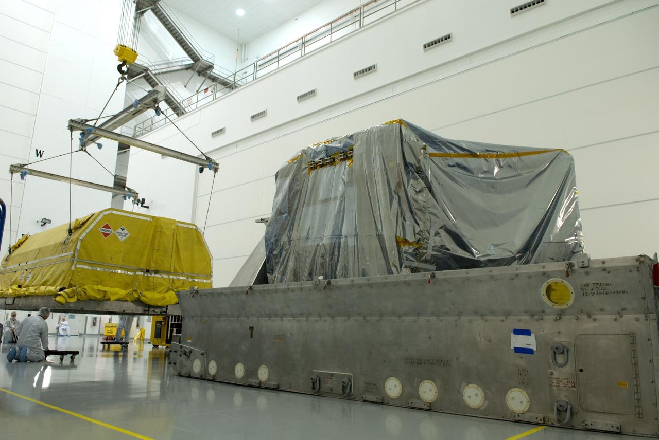
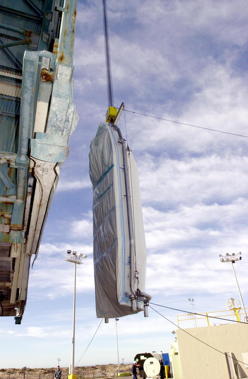
VANDENBERG AIR FORCE BASE, CALIF. - At Vandenberg Air Force Base in California, the container holding the National Oceanic and Atmospheric Administration (NOAA-N) spacecraft arrives inside a hangar where it will undergo preflight processing. NOAA-N is the fourth in the series of support dedicated microwave instruments for the generation of temperature, moisture, surface, and hydrological products in cloudy regions where visible and infrared (IR) instruments have decreased capability. Launch aboard a Boeing Delta II rocket is currently scheduled for no earlier than May 11, 2005.
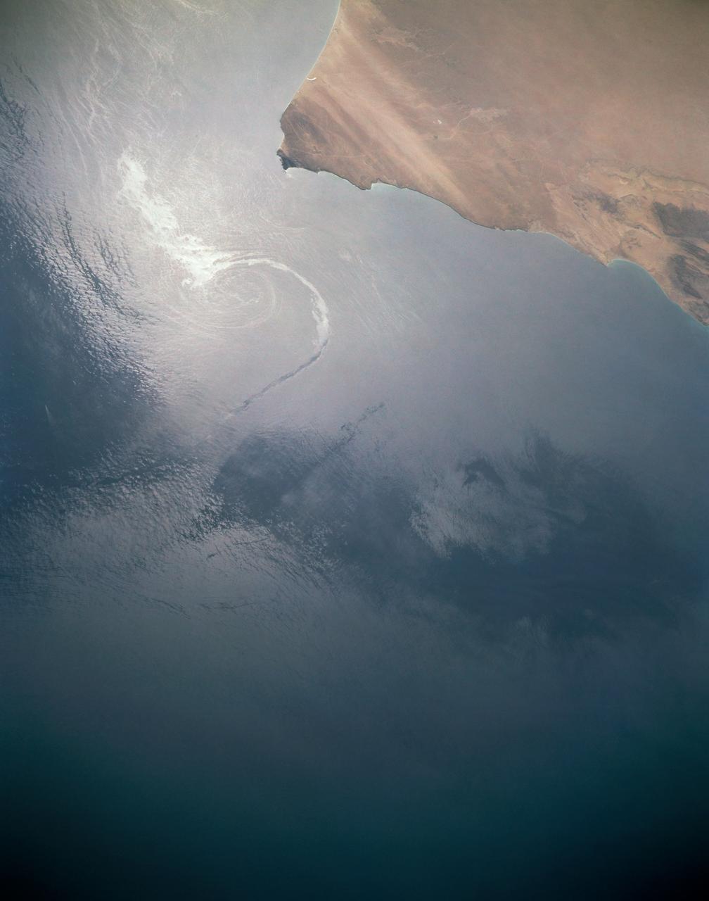
In this sunglint view of the Arabian Seacoast of Oman (19.0N, 59.0E) an oil slick is highlighted on the water's surface by sunglint lighting conditions. Nearly 50 percent of the oil transported worldwide passes through the Gulf of Oman, en route from the Persian Gulf and numerous ship wakes can be seen in this view. The oil slick, rounding the tip of Cape Ras Al Hadd, has formed a counterclockwise bright spiral indicating the local ocean currents.
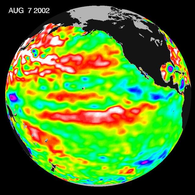
This Topex/Poseidon image of sea-surface heights was taken during a 10-day collection cycle ending August 7, 2002. Sea-surface heights are a measure of how much heat is stored in the ocean below to influence future planetary climate events. Since May 2001, there have been a series of warm Kelvin waves--eastward-moving ocean waves that cross the equatorial Pacific in about two months. A sizable one arrived at the South American coast last February, raising the ocean temperature by 2 degrees Celsius (3.6 degrees Fahrenheit) and triggering the National Oceanic and Atmospheric Administration's forecast for a mild El Niño in 2002. There was another wave in June, followed by the current large pool of warm water in the tropical Pacific that is now moving toward the coast of South America at a speed of 215 kilometers (134 miles) a day and will arrive there in three to four weeks, raising ocean temperatures. Scientists will continue to monitor the Pacific closely for further signs of El Niño formation and intensity. http://photojournal.jpl.nasa.gov/catalog/PIA03855
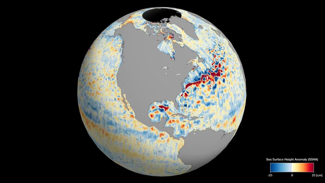
This animation shows global sea level data collected by the Surface Water and Ocean Topography (SWOT) satellite during its first 21-day science orbit, which it completed from July 26 to Aug. 16, 2023. Red and orange indicate ocean heights that were higher than the global mean sea surface height, while blue represents lower-than-the mean. Sea level differences can highlight ocean currents, like the Gulf Stream coming off the U.S. East Coast or the Kuroshio current off the east coast of Japan. Increased sea surface heights can also indicate regions of relatively warmer water – like the eastern part of the equatorial Pacific Ocean during an El Niño – because water expands as it warms. The SWOT science team made the measurements using the spacecraft's Ka-band Radar Interferometer (KaRIn) instrument. With two antennas spread 33 feet (10 meters) apart on a boom, KaRIn produces a pair of data swaths (tracks visible in the animation) as it circles the globe, bouncing radar pulses off the water's surface to collect surface-height measurements. Launched on Dec. 16, 2022, from Vandenberg Space Force Base in central California, SWOT is now in its operations phase, measuring the height of nearly all water on Earth's surface. The satellite will provide one of the most detailed, comprehensive views yet of the planet's oceans and fresh water lakes and rivers, collecting data that will be used for research and other purposes. Animation available at https://photojournal.jpl.nasa.gov/catalog/PIA26100
VANDENBERG AIR FORCE BASE, CALIF. - The logo of the National Oceanic and Atmospheric Administration is affixed to the side of the Boeing Delta II rocket that will launch the NOAA-N rocket. Launch is currently scheduled for no earlier than May 11, 2005. NOAA-N is the fourth in the series of support dedicated microwave instruments for the generation of temperature, moisture, surface, and hydrological products in cloudy regions where visible and infrared (IR) instruments have decreased capability. Launch of NOAA-N aboard the Boeing Delta II rocket is currently scheduled for May 11, 2005. NOAA-N is the fourth in the series of support dedicated microwave instruments for the generation of temperature, moisture, surface, and hydrological products in cloudy regions where visible and infrared (IR) instruments have decreased capability.
ISS006-E-51456 (2003) --- Marias Islands, Mexico is featured in this image photographed by an Expedition Six crewmember on the International Space Station. The view shows the land-sea interactions along a section of Mexico's west coast just south of Mazatlan and the Isla Marias archipelago. The islands are a manifestation of intersecting plate boundaries -- the East Pacific Rise spreading center that traces south from the Gulf of California, and the subduction zone that consumes the Cocos plate beneath southern Mexico. These islands are biologically important: they comprise the Islas Marias Biosphere Reserve and contain endemic species of raccoons and rabbits, and important habitat for birds and marine life. Between the islands and the mainland, swirling surface currents are highlighted by the sun glint reflecting off the ocean surface. Along the Mexican coast, water flows out from a coastal lagoon, and near shore currents carry sediment (light colored water) along the beach front.
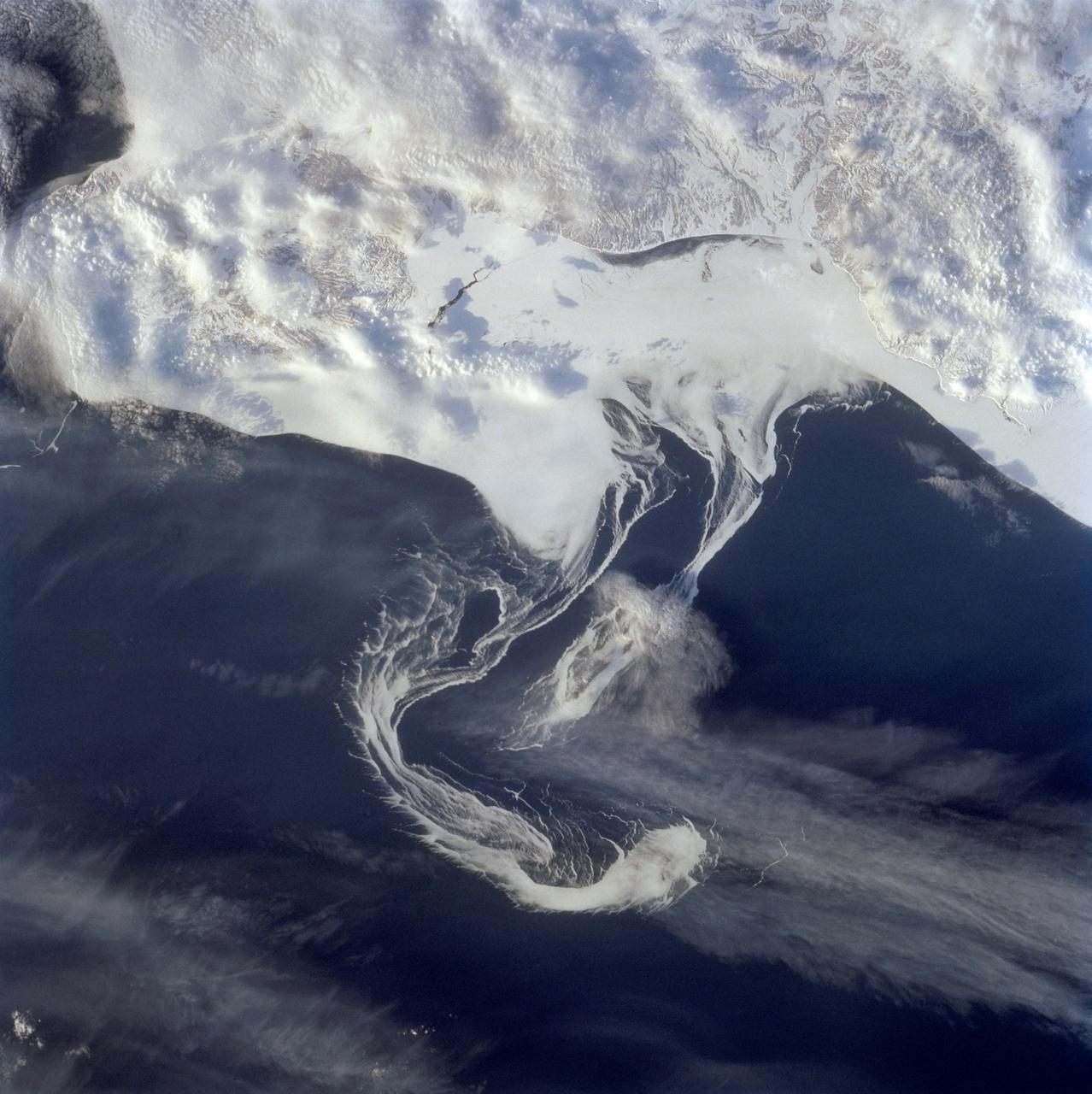
STS060-73-038 (3-11 Feb 1994) --- Pack ice is documented in this photograph along the coast of the Kamchatka Peninsula of Russia in Zaliv Ozernoj. Newly formed ice continually breaks away from the land and takes the form imposed by coastal currents. Detailed photographs of the ice provide information to scientists in both Russia and the united States about the location and fluctuation of ice edges, and how this new sea ice interacts with ocean and littoral currents. This information results in better ice warnings to shipping traffic and provides data points for long-range climate change research for both the Mission-To-Planet Earth and the Russian Priroda ("Nature") monitoring and assessment programs that are respectively coordinated by NASA and the Russian Academy of Sciences. This photography of ice development in the North Pacific, North Atlantic, the Southern Ocean, the Baltic and North Seas, and the Great Lakes is of great interest to the international scientific community. NASA scientists feel high-resolution analog and digital photography from the Space Shuttle and future craft can be a particularly important component in satisfying their data needs on both an operational and a long-term research basis.
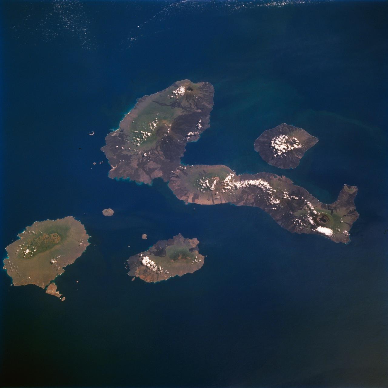
STS077-711-012 (19-29 May 1996) --- One of several volcanic-laden photo targets for the crew members was the grouping of the Galapagos Islands -composites of flat-topped volcanoes produced by a hot spot in the eastern Pacific. Dark lava flows drape the flanks of each volcano. This view centers on Isabella, the sea horse-shaped island. The most active volcano is the island of Fernandina, which sits just west (up) from the sea horse?s middle area. Fernandina erupted late last year, and Shuttle photography has documented the changes produced by eruptions over the past 10 years. Because the Galapagos Islands sit on the equator and near the junction of current systems in the eastern Pacific Ocean, and the volcano provides a sharp topographic barrier to the currents, many interesting oceanic phenomena occur and have been recorded in this region. Lighter colored water occurs just west of Isabella and Fernandina. The origin of the color difference is unknown, but could possibly be plankton blooms related to upwelling around the islands.
ISS030-E-162344 (15 March 2012) --- Ice floes along the Kamchatka coastline are featured in this image photographed by an Expedition 30 crew member on the International Space Station. The vantage point from orbit frequently affords the opportunity to observe processes that are impossible to see on the ground – or in this case the northeastern Pacific Ocean. The winter season blankets the Kamchatka Peninsula of Russia in snow, but significant amounts of sea ice can also form and collect along the coastline. As ice floes grind against each other, they produce smaller floes that can be moved by wind and water currents acting along the coastline. The irregular southeastern coastline of Kamchatka helps to produce large circular eddy currents from the main southwestward-flowing Kamchatka current. Three such eddies are clearly highlighted by surface ice floe patterns at center. The ice patterns are very difficult (and dangerous) to navigate in an ocean vessel – while the floes may look thin and delicate from the space station vantage point, even the smaller ice chunks are likely several meters across. White clouds at top right are distinguished from the sea ice and snow cover in the image by their high brightness and discontinuous nature. The Kamchatka Peninsula also hosts many currently and historically active stratovolcanoes. Kliuchevskoi Volcano, the highest in Kamchatka (summit elevation 4,835 meters) and one of the most active, had its most recent confirmed eruption in June of 2011, while Karymsky Volcano to the south likely produced ash plumes days before this image was taken; the snow cover near the volcano to the south and east of the summit is darkened, probably due to a cover of fresh ash, or melted away altogether (bottom center). In contrast, Kronotsky Volcano – a “textbook” symmetrical cone-shaped stratovolcano – last erupted in 1923.
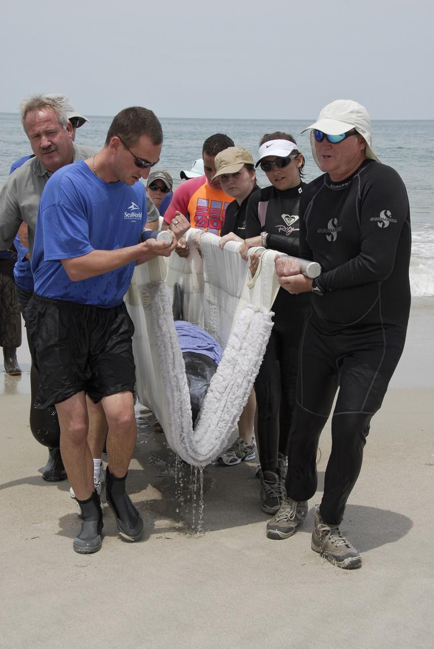
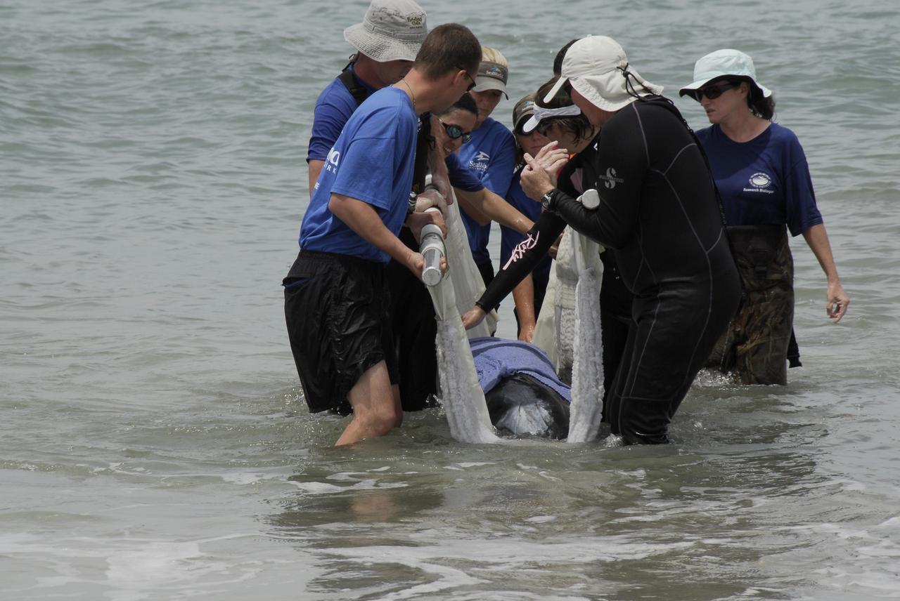
CAPE CANAVERAL, Fla. – Workers from NASA's Kennedy Space Center, a veterinarian and representatives from the Hubbs/Sea World Research Institute support a stranded Melon-Headed Whale on a sling as they carry it out of the Atlantic Ocean. The whale was found beached south of Launch Pad 39A near Cape Canaveral Air Force Station. After assessment by veterinarians at Sea World, the whale will be transported to a whale rescue center in the Panhandle for rehabilitation and release. The Melon-Headed Whale lives well off-shore in all the world's tropical and sub-tropical oceans. At the northern fringes of its range, it may also be found in the warm currents of temperate waters, such as Florida. It is closely related to the Pygmy Killer Whale and the Pilot Whales. Its primary diet is squid. Photo credit: NASA/Kim Shiflett
STS061-106-091 (December 1993) --- The entire southern tip of Africa is shown in this high altitude 50mm photograph. The center of the photograph is at approximately 28.0 degrees south and 24.0 degrees east Cape Columbine is at the upper right with Durban at the lower center. The Orange River is at the upper center of the frame. Cape Agulas is the southernmost part of the African continent and is visible toward the upper right corner with the great bays of South Africa trending toward the bottom right. Continuing clockwise along the coast, Durban projects out into the Indian Ocean. The oceanic clouds on the right side of the photograph probably depict a current boundary. The Drakensberg Range on the east, the great Karoo Range to the south and the Karas Mountains on the west surround the drier central plateau. The southern Kalahari Desert is at the upper left of the photograph.
CAPE CANAVERAL, Fla. – Workers from NASA's Kennedy Space Center and representatives from the Hubbs/Sea World Research Institute support a stranded Melon-Headed Whale on a sling in the Atlantic Ocean. The whale was found beached south of Launch Pad 39A near Cape Canaveral Air Force Station. After assessment by veterinarians at Sea World, the whale will be transported to a whale rescue center in the Panhandle for rehabilitation and release. The Melon-Headed Whale lives well off-shore in all the world's tropical and sub-tropical oceans. At the northern fringes of its range, it may also be found in the warm currents of temperate waters, such as Florida. It is closely related to the Pygmy Killer Whale and the Pilot Whales. Its primary diet is squid. Photo credit: NASA/Kim Shiflett
VANDENBERG AIR FORCE BASE, CALIF. - On Space Launch Complex 2 at Vandenberg Air Force Base in California, the two fairing sections for the National Oceanic and Atmospheric Administration (NOAA-N) spacecraft are ready to be lifted up the launch service tower. The fairing is placed around the spacecraft to protect it during launch. NOAA-N is the fourth in the series of support dedicated microwave instruments for the generation of temperature, moisture, surface, and hydrological products in cloudy regions where visible and infrared (IR) instruments have decreased capability. Launch aboard a Boeing Delta II rocket is currently scheduled for no earlier than May 11, 2005.

CAPE CANAVERAL, Fla. – At the Astrotech Space Operations facility in Titusville, Fla., workers uncrate NASA's newly arrived GOES-P meteorological satellite. GOES-P, the latest Geostationary Operational Environmental Satellite, was developed by NASA for the National Oceanic and Atmospheric Administration, or NOAA. GOES-P is designed to watch for storm development and observed current weather conditions on Earth. Launch of GOES-P is targeted for no earlier than Feb. 25, 2010, from Launch Complex 37 aboard a United Launch Alliance Delta IV rocket. For information on GOES-P, visit http://goespoes.gsfc.nasa.gov/goes/spacecraft/n_p_spacecraft.html. Photo credit: NASA/Glenn Benson
VANDENBERG AIR FORCE BASE, CALIF. - Inside the NASA spacecraft processing hangar 1610 located on North Vandenberg Air Force Base in California, the National Oceanic and Atmospheric Administration (NOAA-N) spacecraft is undergoing testing. The testing includes the Spacecraft Electrical Performance Test, battery conditioning, a Solar Array Illumination Telemetry Test, final instrument inspections and closeouts for flight. Launch of NOAA-N aboard the Boeing Delta II rocket is currently scheduled for May 11, 2005. NOAA-N is the fourth in the series of support dedicated microwave instruments for the generation of temperature, moisture, surface, and hydrological products in cloudy regions where visible and infrared (IR) instruments have decreased capability.
CAPE CANAVERAL, Fla. – At the Astrotech Space Operations facility in Titusville, Fla., workers lift the transportation cover from NASA's newly arrived GOES-P meteorological satellite. GOES-P, the latest Geostationary Operational Environmental Satellite, was developed by NASA for the National Oceanic and Atmospheric Administration, or NOAA. GOES-P is designed to watch for storm development and observed current weather conditions on Earth. Launch of GOES-P is targeted for no earlier than Feb. 25, 2010, from Launch Complex 37 aboard a United Launch Alliance Delta IV rocket. For information on GOES-P, visit http://goespoes.gsfc.nasa.gov/goes/spacecraft/n_p_spacecraft.html. Photo credit: NASA/Glenn Benson
CAPE CANAVERAL, Fla. – At the Astrotech Space Operations facility in Titusville, Fla., workers prepare to lift NASA's newly arrived GOES-P meteorological satellite from its transportation case. GOES-P, the latest Geostationary Operational Environmental Satellite, was developed by NASA for the National Oceanic and Atmospheric Administration, or NOAA. GOES-P is designed to watch for storm development and observed current weather conditions on Earth. Launch of GOES-P is targeted for no earlier than Feb. 25, 2010, from Launch Complex 37 aboard a United Launch Alliance Delta IV rocket. For information on GOES-P, visit http://goespoes.gsfc.nasa.gov/goes/spacecraft/n_p_spacecraft.html. Photo credit: NASA/Glenn Benson
VANDENBERG AIR FORCE BASE, CALIF. - Inside the NASA spacecraft processing hangar 1610 located on North Vandenberg Air Force Base in California, the National Oceanic and Atmospheric Administration (NOAA-N) spacecraft is undergoing testing. The testing includes a Spacecraft Electrical Performance Test, battery conditioning, a Solar Array Illumination Telemetry Test, final instrument inspections and closeouts for flight. Launch of NOAA-N aboard the Boeing Delta II rocket is currently scheduled for May 11, 2005. NOAA-N is the fourth in the series of support dedicated microwave instruments for the generation of temperature, moisture, surface, and hydrological products in cloudy regions where visible and infrared (IR) instruments have decreased capability.
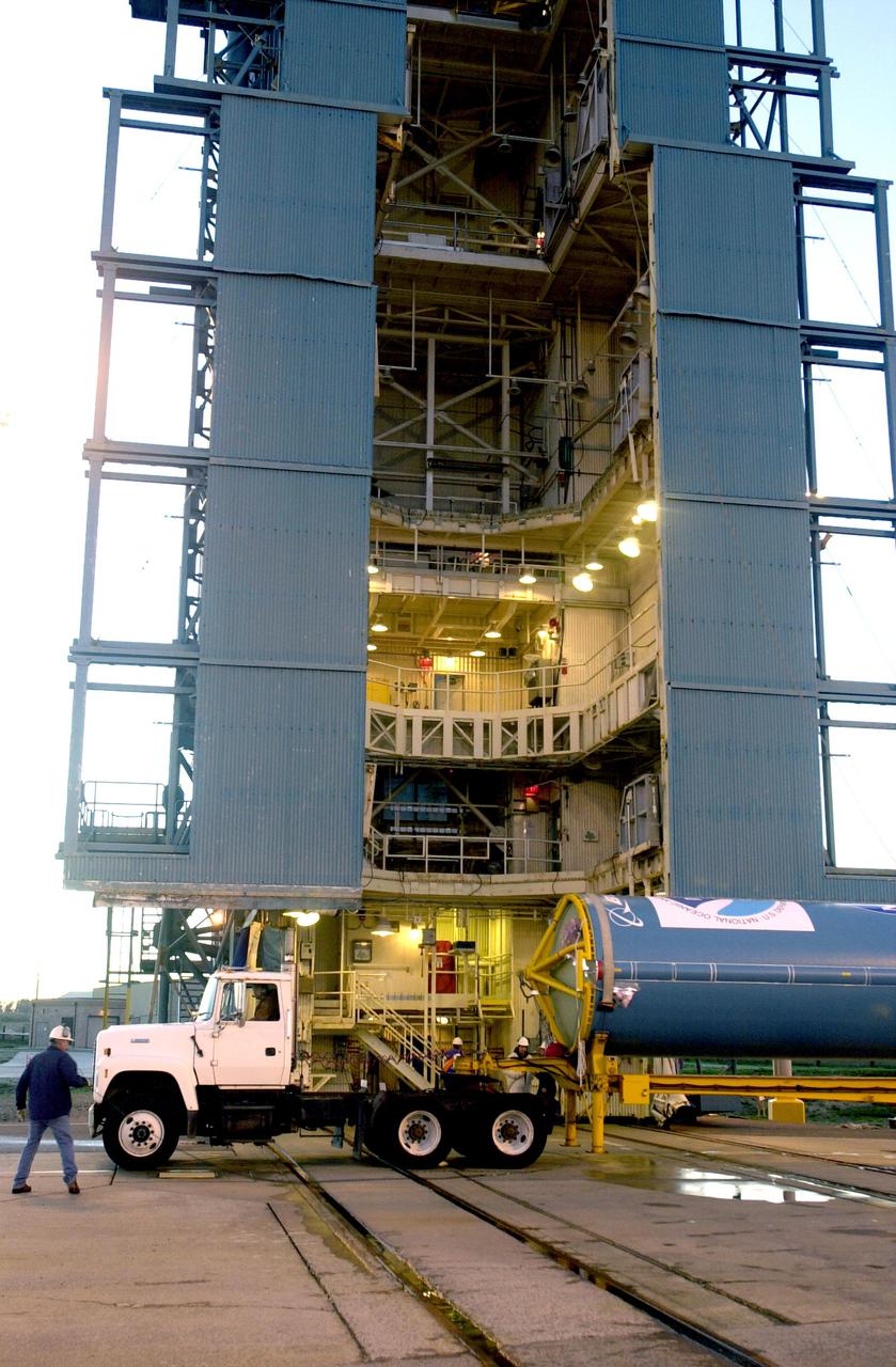
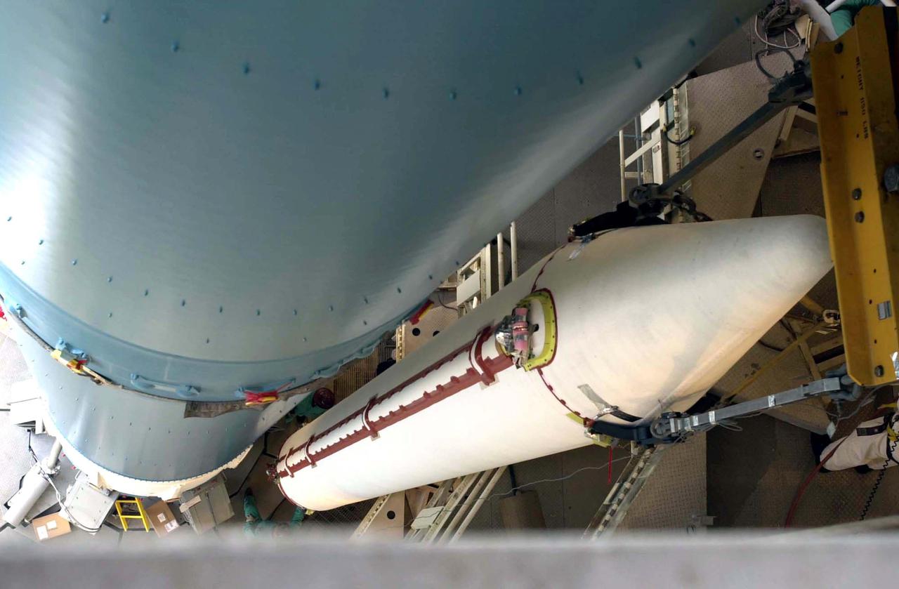
VANDENBERG AIR FORCE BASE, CALIF. - The first stage of a Boeing Delta 2 rocket arrives at the launch service tower on Space Launch Complex 2 at Vandenberg Air Force Base in California. The Delta 2 is the launch vehicle for the National Oceanic and Atmospheric Administration (NOAA-N) spacecraft. NOAA-N is the fourth in the series of support dedicated microwave instruments for the generation of temperature, moisture, surface, and hydrological products in cloudy regions where visible and infrared (IR) instruments have decreased capability. Launch aboard a Boeing Delta II rocket is currently scheduled for no earlier than May 11, 2005.
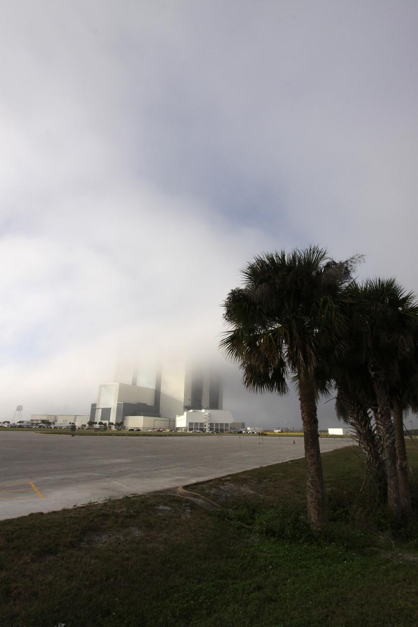
CAPE CANAVERAL, Fla. – At NASA's Kennedy Space Center in Florida, dense fog moving ashore from the Atlantic Ocean engulfs the Vehicle Assembly Building on an atypical December afternoon. It is the second time in one day that fog has obscured the top of the 525-foot-tall processing facility, known as the VAB. Space Shuttle Endeavour currently is in the VAB's High Bay 1 where it is being attached to its external fuel tank and solid rocket boosters in preparation for its targeted launch in early February 2010. Photo credit: NASA/Jack Pfaller
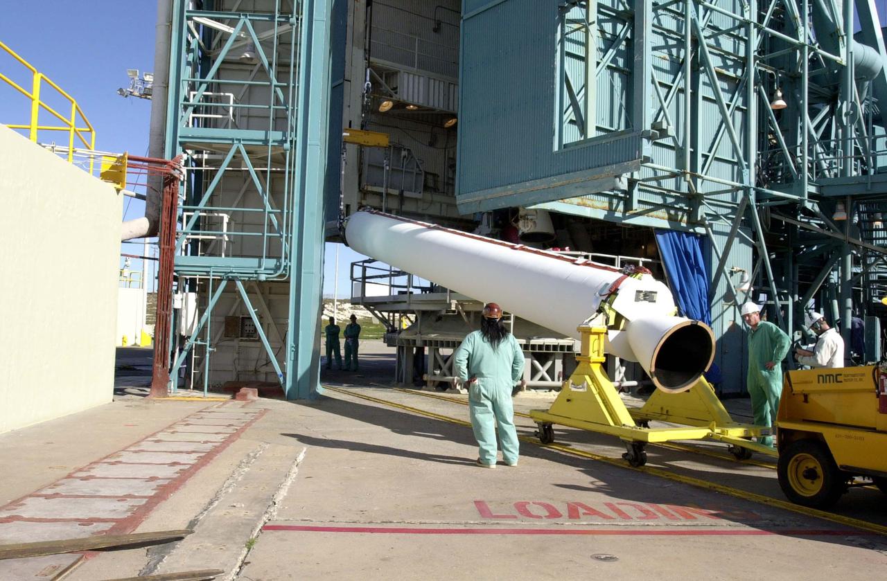
VANDENBERG AIR FORCE BASE, CALIF. - On Space Launch Complex 2 at Vandenberg Air Force Base in California, one of the two fairing sections for the National Oceanic and Atmospheric Administration (NOAA-N) spacecraft is raised to a vertical position for lifting up into the launch service tower. The fairing will be placed around the spacecraft to protect it during launch. NOAA-N is the fourth in the series of support dedicated microwave instruments for the generation of temperature, moisture, surface, and hydrological products in cloudy regions where visible and infrared (IR) instruments have decreased capability. Launch aboard a Boeing Delta II rocket is currently scheduled for no earlier than May 11, 2005.
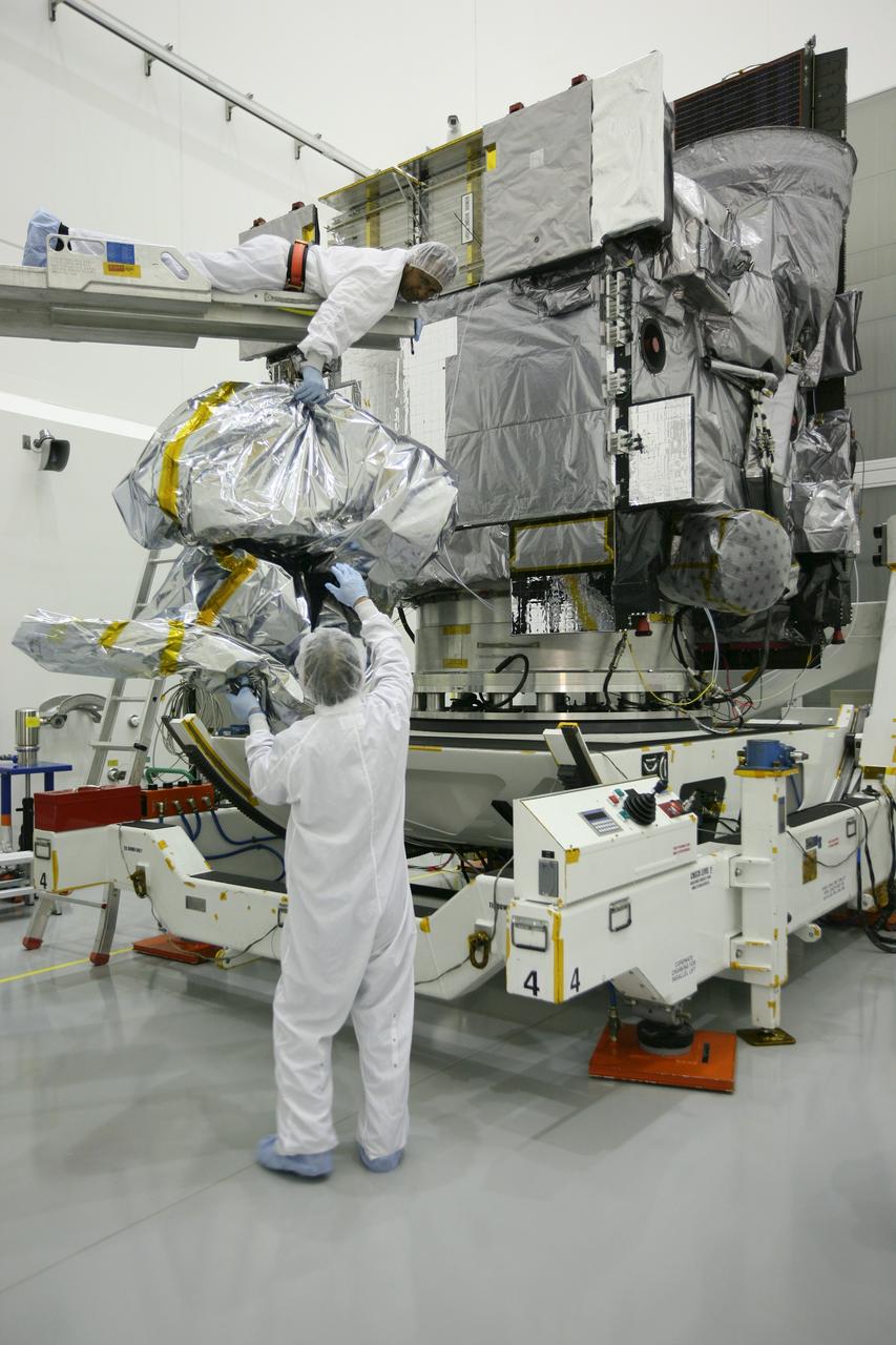
VANDENBERG AIR FORCE BASE, CALIF. - Inside the NASA spacecraft processing hangar 1610 located on North Vandenberg Air Force Base in California, Lockheed Martin workers place a protective cover around the National Oceanic and Atmospheric Administration (NOAA-N) spacecraft. Mechanical and electrical ground support equipment will be set up and the necessary connections made with the spacecraft. Launch of NOAA-N aboard the Boeing Delta II rocket is currently scheduled for May 11, 2005. NOAA-N is the fourth in the series of support dedicated microwave instruments for the generation of temperature, moisture, surface, and hydrological products in cloudy regions where visible and infrared (IR) instruments have decreased capability.
VANDENBERG AIR FORCE BASE, CALIF. - - The interstage of a Boeing Delta 2 rocket is lifted up the launch service tower on Space Launch Complex 2 at Vandenberg Air Force Base in California. It will be mated with the first stage in the launch service tower. The Delta 2 is the launch vehicle for the National Oceanic and Atmospheric Administration (NOAA-N) spacecraft. NOAA-N is the fourth in the series of support dedicated microwave instruments for the generation of temperature, moisture, surface, and hydrological products in cloudy regions where visible and infrared (IR) instruments have decreased capability. Launch aboard a Boeing Delta II rocket is currently scheduled for no earlier than May 11, 2005.
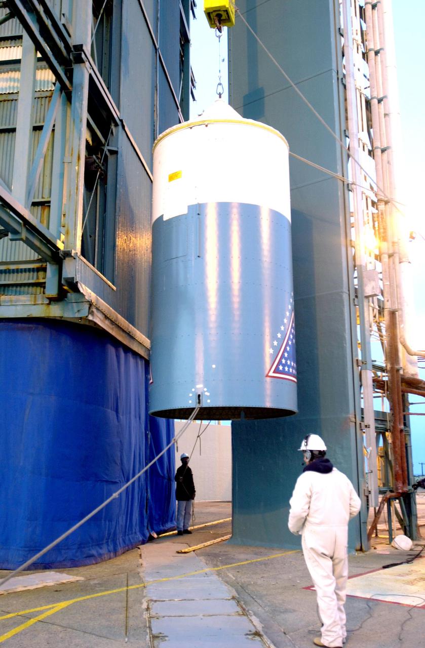
VANDENBERG AIR FORCE BASE, CALIF. - After its arrival at Space Launch Complex 2 on Vandenberg Air Force Base in California, one of three Solid Rocket Boosters is lifted from the transporter and will be raised to a vertical position. It will be lifted up the launch service tower and mated with a Boeing Delta II rocket for the launch of the National Oceanic and Atmospheric Administration (NOAA-N) spacecraft. Launch of NOAA-N aboard the Boeing Delta II rocket is currently scheduled for May 11, 2005. NOAA-N is the fourth in the series of support dedicated microwave instruments for the generation of temperature, moisture, surface, and hydrological products in cloudy regions where visible and infrared (IR) instruments have decreased capability.

CAPE CANAVERAL, Fla. – Dense fog engulfs Launch Complex 39 at NASA's Kennedy Space Center in Florida, obscuring the view of the 525-foot-tall Vehicle Assembly Building. The fog pushed onshore from the Atlantic Ocean for the second time in one day to create atypical conditions on this humid December afternoon. Space Shuttle Endeavour currently is in the VAB's High Bay 1 where it is being attached to its external fuel tank and solid rocket boosters in preparation for its targeted launch in early February 2010. Photo credit: NASA/Jack Pfaller
CAPE CANAVERAL, Fla. – At the Astrotech Space Operations facility in Titusville, Fla., the protective wrapping has been removed from NASA's GOES-P meteorological satellite. GOES-P, the latest Geostationary Operational Environmental Satellite, was developed by NASA for the National Oceanic and Atmospheric Administration, or NOAA. GOES-P is designed to watch for storm development and observed current weather conditions on Earth. Launch of GOES-P is targeted for no earlier than March 1 from Launch Complex 37 aboard a United Launch Alliance Delta IV rocket. For information on GOES-P, visit http://goespoes.gsfc.nasa.gov/goes/spacecraft/n_p_spacecraft.html. Photo credit: NASA/Amanda Diller
VANDENBERG AIR FORCE BASE, CALIF. - Inside the NASA spacecraft processing hangar 1610 located on North Vandenberg Air Force Base in California, the National Oceanic and Atmospheric Administration (NOAA-N) spacecraft is undergoing testing. The testing includes the Spacecraft Electrical Performance Test, battery conditioning, a Solar Array Illumination Telemetry Test, final instrument inspections and closeouts for flight. Launch of NOAA-N aboard the Boeing Delta II rocket is currently scheduled for May 11, 2005. NOAA-N is the fourth in the series of support dedicated microwave instruments for the generation of temperature, moisture, surface, and hydrological products in cloudy regions where visible and infrared (IR) instruments have decreased capability.
VANDENBERG AIR FORCE BASE, CALIF. - On Space Launch Complex 2 at Vandenberg Air Force Base in California, one of the two fairing sections for the National Oceanic and Atmospheric Administration (NOAA-N) spacecraft arrives at the launch service tower where it will be lifted to an upper level. The fairing will be placed around the spacecraft to protect it during launch. NOAA-N is the fourth in the series of support dedicated microwave instruments for the generation of temperature, moisture, surface, and hydrological products in cloudy regions where visible and infrared (IR) instruments have decreased capability. Launch aboard a Boeing Delta II rocket is currently scheduled for no earlier than May 11, 2005.
CAPE CANAVERAL, Fla. – At the Astrotech Space Operations facility in Titusville, Fla., it takes teamwork among the spacecraft technicians to unbag or remove the protective wrapping from NASA's GOES-P meteorological satellite. GOES-P, the latest Geostationary Operational Environmental Satellite, was developed by NASA for the National Oceanic and Atmospheric Administration, or NOAA. GOES-P is designed to watch for storm development and observed current weather conditions on Earth. Launch of GOES-P is targeted for no earlier than March 1 from Launch Complex 37 aboard a United Launch Alliance Delta IV rocket. For information on GOES-P, visit http://goespoes.gsfc.nasa.gov/goes/spacecraft/n_p_spacecraft.html. Photo credit: NASA/Amanda Diller
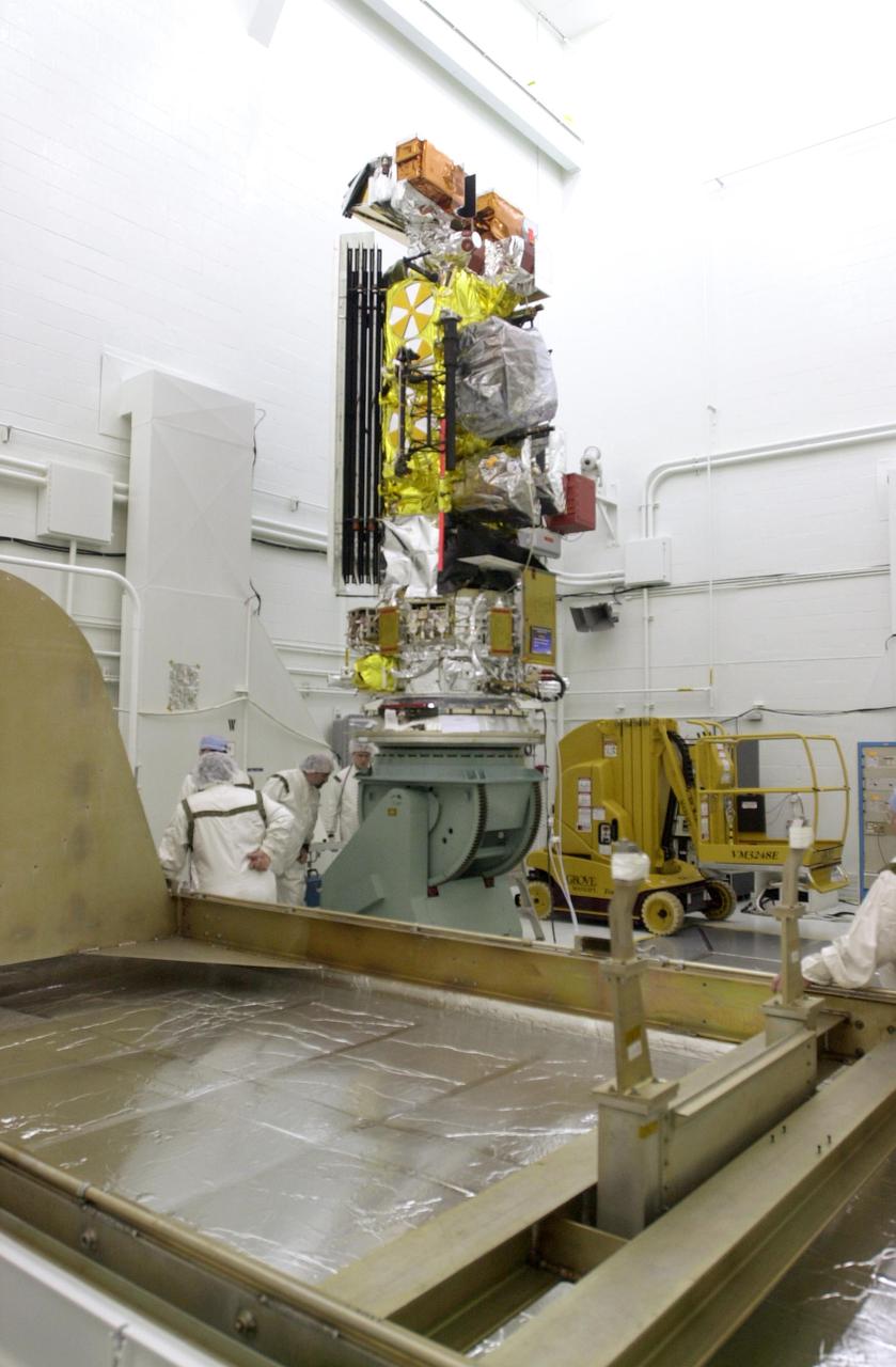
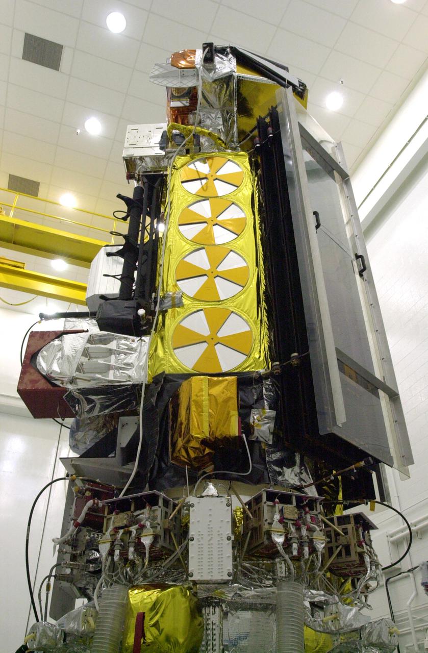
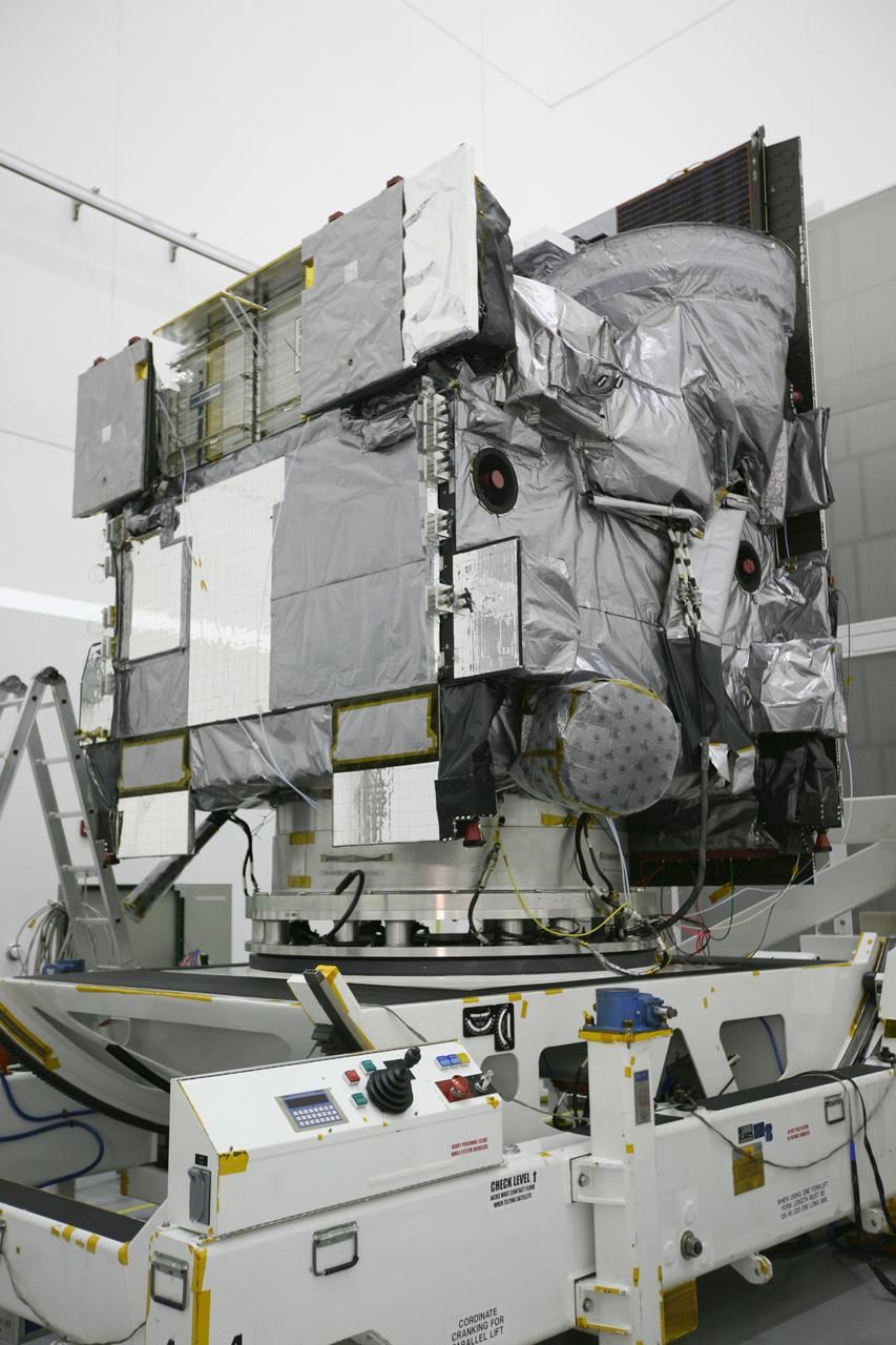
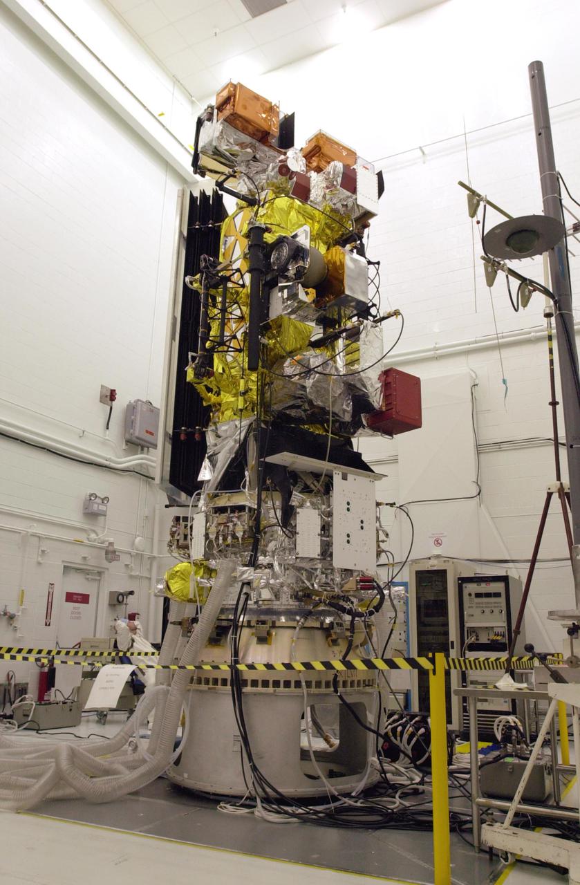
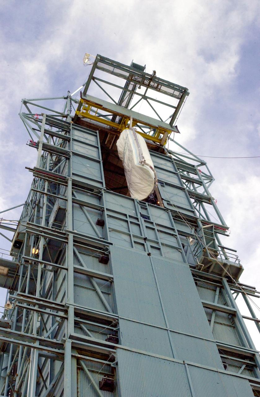
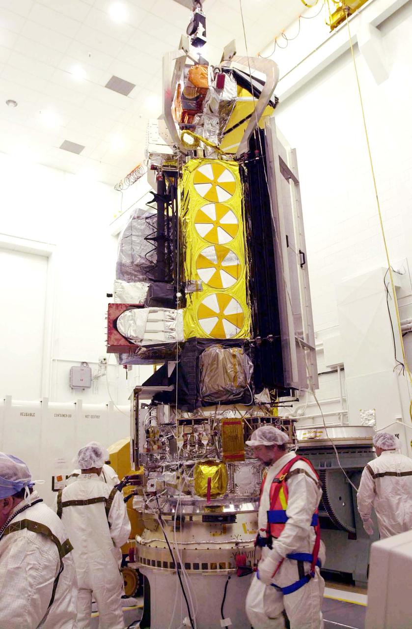
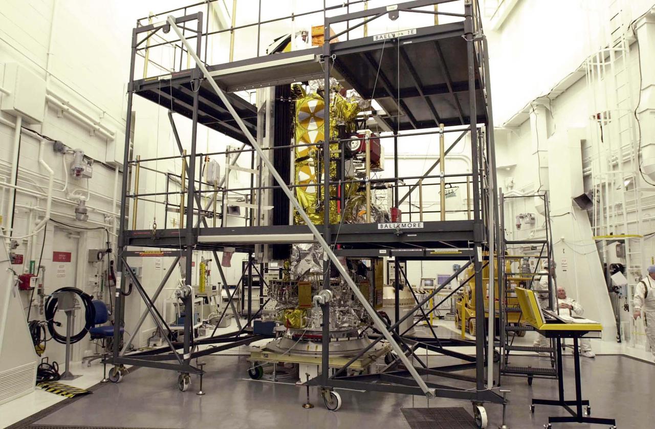
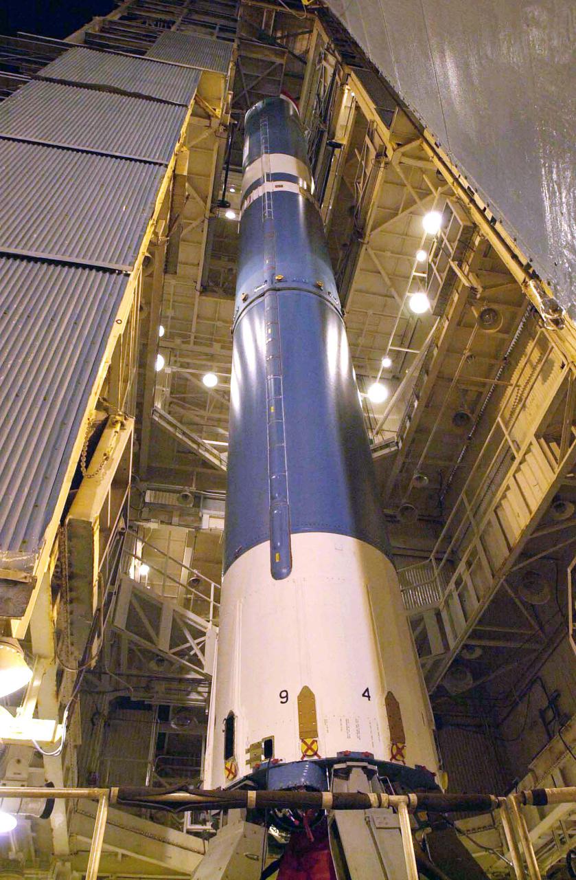
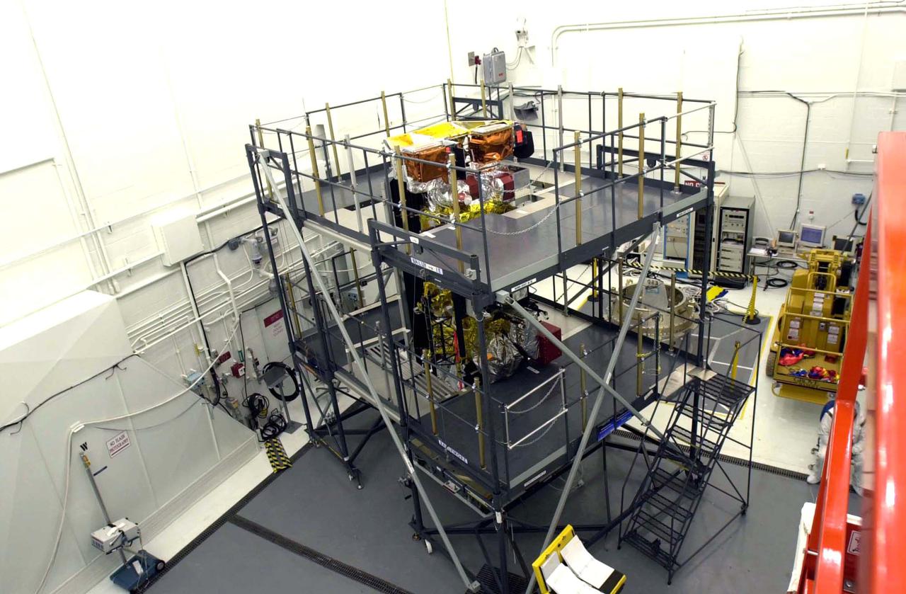
VANDENBERG AIR FORCE BASE, CALIF. - Inside the NASA spacecraft processing hangar 1610 located on North Vandenberg Air Force Base in California, the National Oceanic and Atmospheric Administration (NOAA-N) spacecraft has been raised to a vertical position on an assembly and test stand. It will be mated to the Delta II payload attach fitting. Launch of NOAA-N aboard the Boeing Delta II rocket is currently scheduled for May 11, 2005. NOAA-N is the fourth in the series of support dedicated microwave instruments for the generation of temperature, moisture, surface, and hydrological products in cloudy regions where visible and infrared (IR) instruments have decreased capability.
VANDENBERG AIR FORCE BASE, CALIF. - On Space Launch Complex 2 at Vandenberg Air Force Base in California, one of the two fairing sections for the National Oceanic and Atmospheric Administration (NOAA-N) spacecraft is being lifted up to an upper level of the launch service tower. The fairing will be placed around the spacecraft to protect it during launch. NOAA-N is the fourth in the series of support dedicated microwave instruments for the generation of temperature, moisture, surface, and hydrological products in cloudy regions where visible and infrared (IR) instruments have decreased capability. Launch aboard a Boeing Delta II rocket is currently scheduled for no earlier than May 11, 2005.
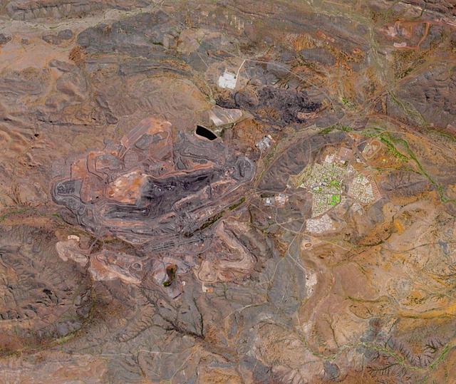
The Mount Whaleback open pit iron ore mine is located 6 km west of the town of Newman in the Pilbara region of Western Australia. It is currently the fifth largest iron mine in the world. The iron occurs in banded iron ore formations, created about 2.5 billion years ago when microorganisms first produced massive amounts of oxygen, oxidizing and precipitating the free iron in the oceans. The image was acquired October 2, 2017, covers an area of 14.4 by 17 km, and is located at 23.3 degrees south, 119.7 degrees east. https://photojournal.jpl.nasa.gov/catalog/PIA24016
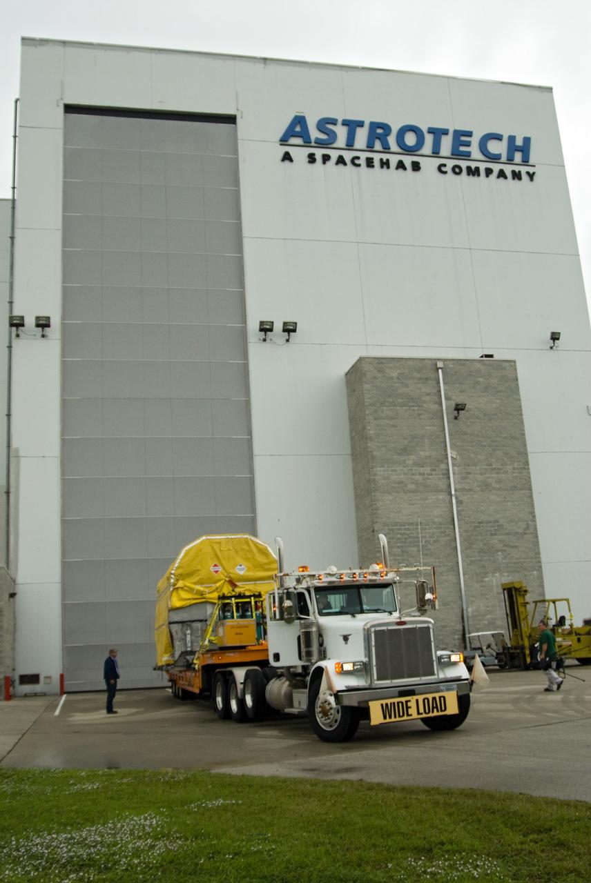
CAPE CANAVERAL, Fla. – At NASA's Kennedy Space Center in Florida, NASA's GOES-P meteorological satellite arrives at the Astrotech Space Operations facility in Titusville, Fla., for final processing before launch. GOES-P, the latest Geostationary Operational Environmental Satellite, was developed by NASA for the National Oceanic and Atmospheric Administration, or NOAA. GOES-P is designed to watch for storm development and observed current weather conditions on Earth. Launch of GOES-P is targeted for no earlier than Feb. 25, 2010, from Launch Complex 37 aboard a United Launch Alliance Delta IV rocket. For information on GOES-P, visit http://goespoes.gsfc.nasa.gov/goes/spacecraft/n_p_spacecraft.html. Photo credit: NASA/Amanda Diller
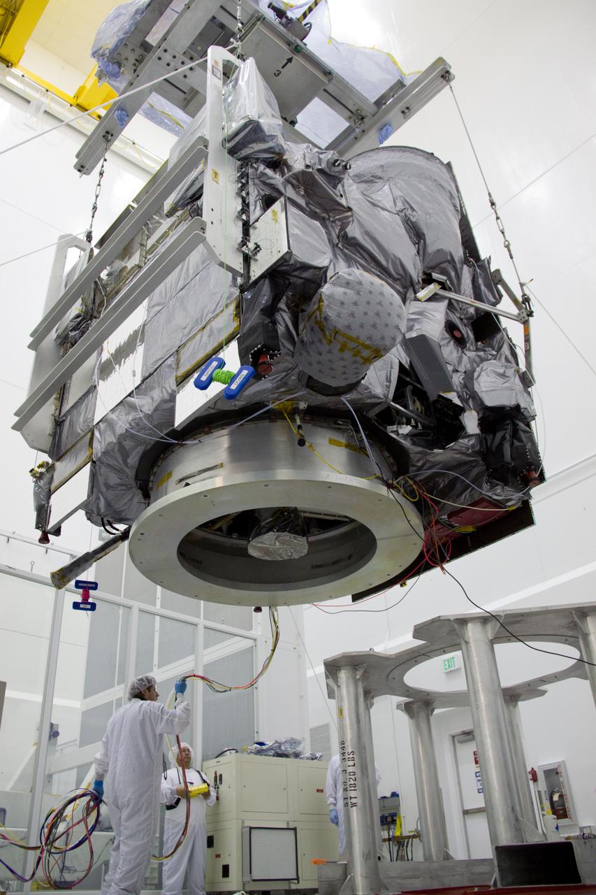
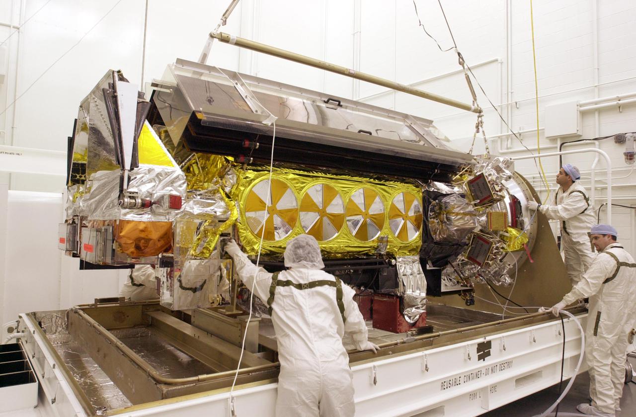
VANDENBERG AIR FORCE BASE, CALIF. - Inside the NASA spacecraft processing hangar 1610 located on North Vandenberg Air Force Base in California, Lockheed Martin workers help guide the suspended National Oceanic and Atmospheric Administration (NOAA-N) spacecraft toward the Boeing Delta II payload attach fitting in the foreground. Launch of NOAA-N aboard the Boeing Delta II rocket is currently scheduled for May 11, 2005. NOAA-N is the fourth in the series of support dedicated microwave instruments for the generation of temperature, moisture, surface, and hydrological products in cloudy regions where visible and infrared (IR) instruments have decreased capability.
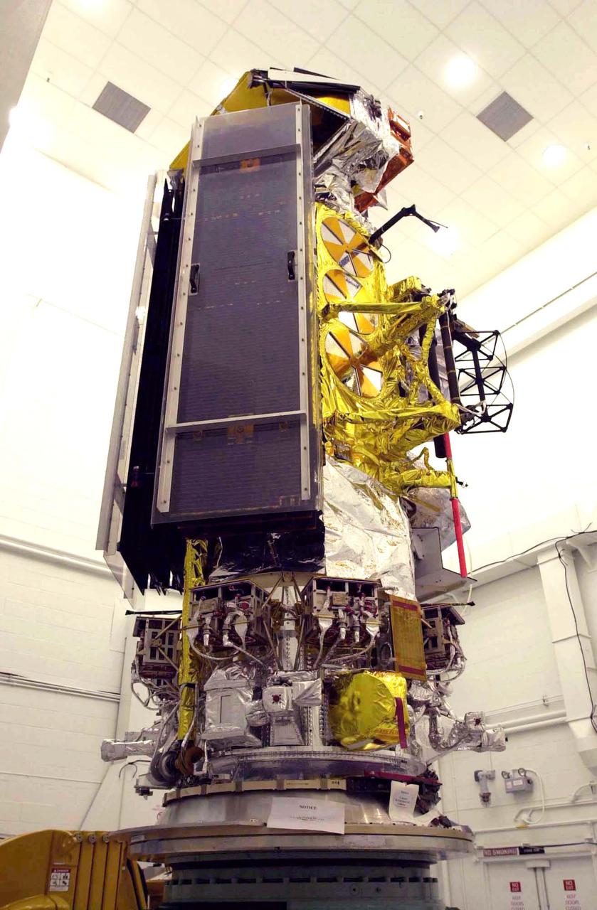
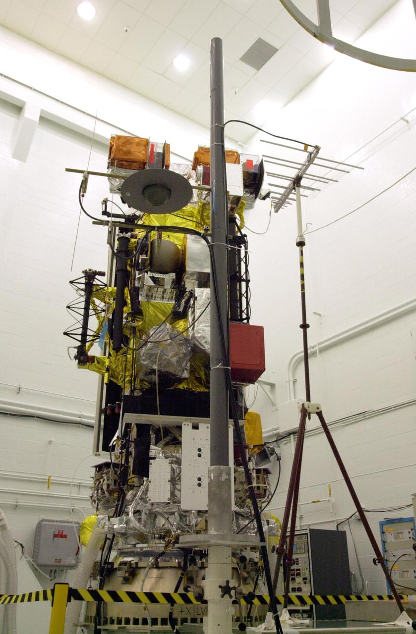
VANDENBERG AIR FORCE BASE, CALIF. - Inside the NASA spacecraft processing hangar 1610 located on North Vandenberg Air Force Base in California, the National Oceanic and Atmospheric Administration (NOAA-N) spacecraft is seen from a different view that includes the solar arrays while on an assembly and test stand. It will be mated to the Delta II payload attach fitting. Launch of NOAA-N aboard the Boeing Delta II rocket is currently scheduled for May 11, 2005. NOAA-N is the fourth in the series of support dedicated microwave instruments for the generation of temperature, moisture, surface, and hydrological products in cloudy regions where visible and infrared (IR) instruments have decreased capability.
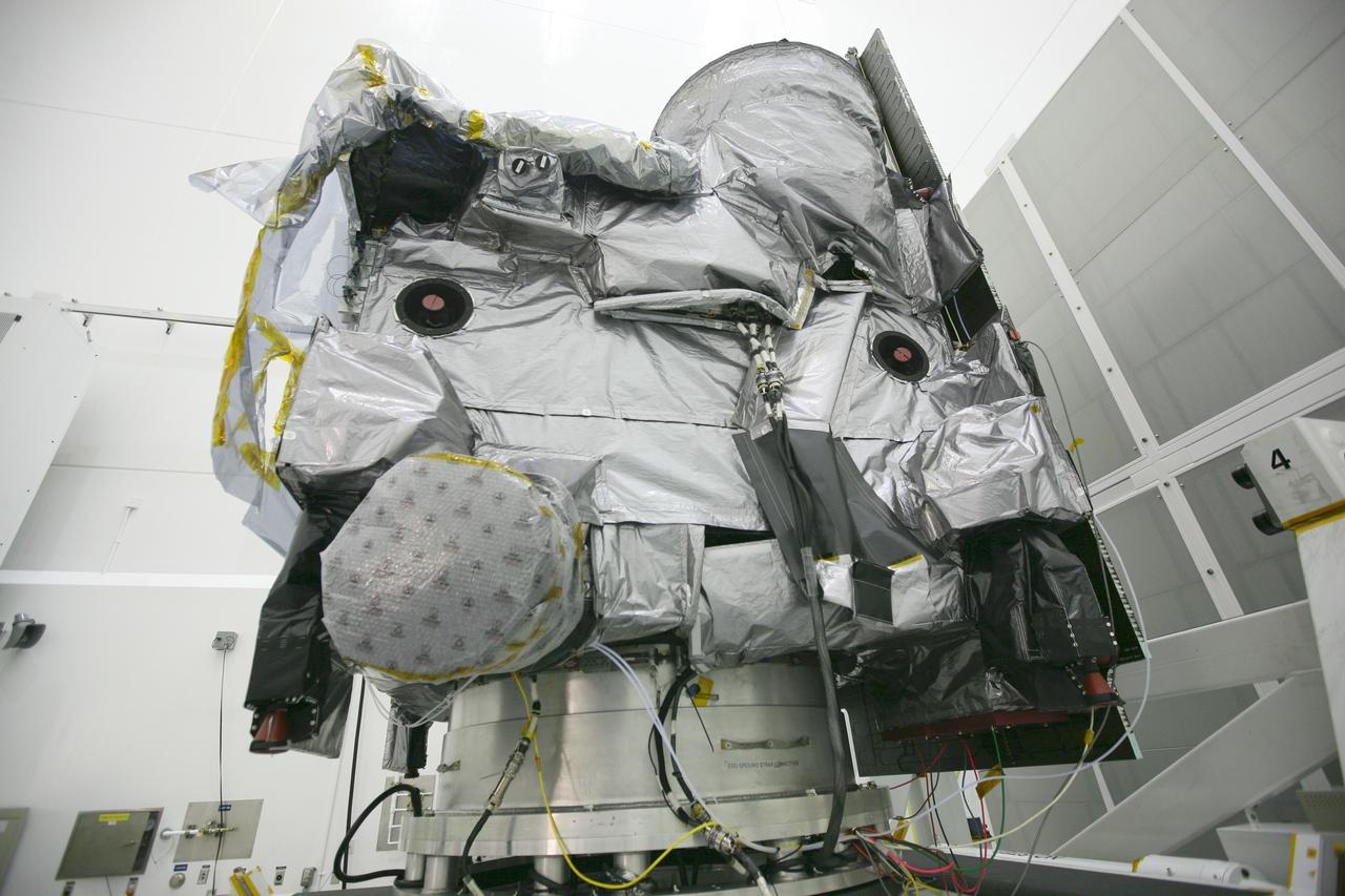
VANDENBERG AIR FORCE BASE, CALIF. - Inside the NASA spacecraft processing hangar 1610 located on North Vandenberg Air Force Base in California, the National Oceanic and Atmospheric Administration (NOAA-N) spacecraft sits attached to the Boeing Delta II payload attach fitting on the bottom. Launch of NOAA-N aboard the Boeing Delta II rocket is currently scheduled for May 11, 2005. NOAA-N is the fourth in the series of support dedicated microwave instruments for the generation of temperature, moisture, surface, and hydrological products in cloudy regions where visible and infrared (IR) instruments have decreased capability.
CAPE CANAVERAL, Fla. – At the Astrotech Space Operations facility in Titusville, Fla., the process to unbag or remove the protective wrapping from NASA's GOES-P meteorological satellite is under way. GOES-P, the latest Geostationary Operational Environmental Satellite, was developed by NASA for the National Oceanic and Atmospheric Administration, or NOAA. GOES-P is designed to watch for storm development and observed current weather conditions on Earth. Launch of GOES-P is targeted for no earlier than March 1 from Launch Complex 37 aboard a United Launch Alliance Delta IV rocket. For information on GOES-P, visit http://goespoes.gsfc.nasa.gov/goes/spacecraft/n_p_spacecraft.html. Photo credit: NASA/Amanda Diller
CAPE CANAVERAL, Fla. – At the Astrotech Space Operations facility in Titusville, Fla., NASA's GOES-P meteorological satellite is ready to be unbagged, or to have its protective wrapping removed. GOES-P, the latest Geostationary Operational Environmental Satellite, was developed by NASA for the National Oceanic and Atmospheric Administration, or NOAA. GOES-P is designed to watch for storm development and observed current weather conditions on Earth. Launch of GOES-P is targeted for no earlier than March 1 from Launch Complex 37 aboard a United Launch Alliance Delta IV rocket. For information on GOES-P, visit http://goespoes.gsfc.nasa.gov/goes/spacecraft/n_p_spacecraft.html. Photo credit: NASA/Amanda Diller
VANDENBERG AIR FORCE BASE, CALIF. - One of three Solid Rocket Boosters arrives at Space Launch Complex 2 on Vandenberg Air Force Base in California. It will be mated with a Boeing Delta II rocket for the launch of the National Oceanic and Atmospheric Administration (NOAA-N) spacecraft. Launch of NOAA-N aboard the Boeing Delta II rocket is currently scheduled for May 11, 2005. NOAA-N is the fourth in the series of support dedicated microwave instruments for the generation of temperature, moisture, surface, and hydrological products in cloudy regions where visible and infrared (IR) instruments have decreased capability.
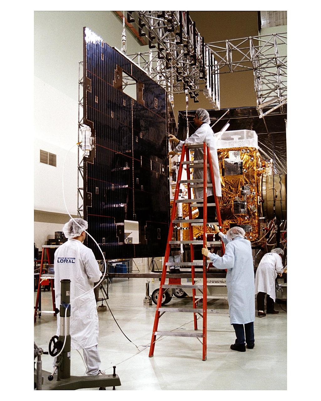
Space Systems/LORAL employees inspect solar panels for the GOES-K weather satellite in the Astrotech facility at Titusville, Fla., as they begin final testing of the imaging system, communications and power systems of the spacecraft. The GOES-K is the third spacecraft to be launched in the new advanced series of geostationary weather satellites for the National Oceanic and Atmospheric Administration (NOAA). The GOES-K is built for NASA and NOAA by Space Systems/LORAL of Palo Alto, Calif. The launch of the satellite from Launch Pad 36B at Cape Canaveral Air Station on an Atlas 1 rocket (AC-79) is currently planned for Apr. 24 at the opening of a launch window which extends from 1:56 to 3:19 a.m. EDT
VANDENBERG AIR FORCE BASE, CALIF. - Inside the NASA spacecraft processing hangar 1610 located on North Vandenberg Air Force Base in California, the National Oceanic and Atmospheric Administration (NOAA-N) spacecraft is raised to a vertical position on an assembly and test stand. It will be mated to the Delta II payload attach fitting. Launch of NOAA-N aboard the Boeing Delta II rocket is currently scheduled for May 11, 2005. NOAA-N is the fourth in the series of support dedicated microwave instruments for the generation of temperature, moisture, surface, and hydrological products in cloudy regions where visible and infrared (IR) instruments have decreased capability.
CAPE CANAVERAL, Fla. – The second stage of a Delta IV rocket awaits checkout in the hangar of the Delta Operations Center at Cape Canaveral Air Force Station in Florida. The United Launch Alliance Delta IV rocket is the vehicle slated to launch GOES-P, the latest Geostationary Operational Environmental Satellite developed by NASA for the National Oceanic and Atmospheric Administration, or NOAA. A meteorological satellite, GOES-P is designed to watch for storm development and observed current weather conditions on Earth. Launch of GOES-P is scheduled for no earlier than Feb. 25, 2010, from Launch Complex 37. For information on GOES-P, visit http://goespoes.gsfc.nasa.gov/goes/spacecraft/n_p_spacecraft.html. Photo credit: NASA/Troy Cryder
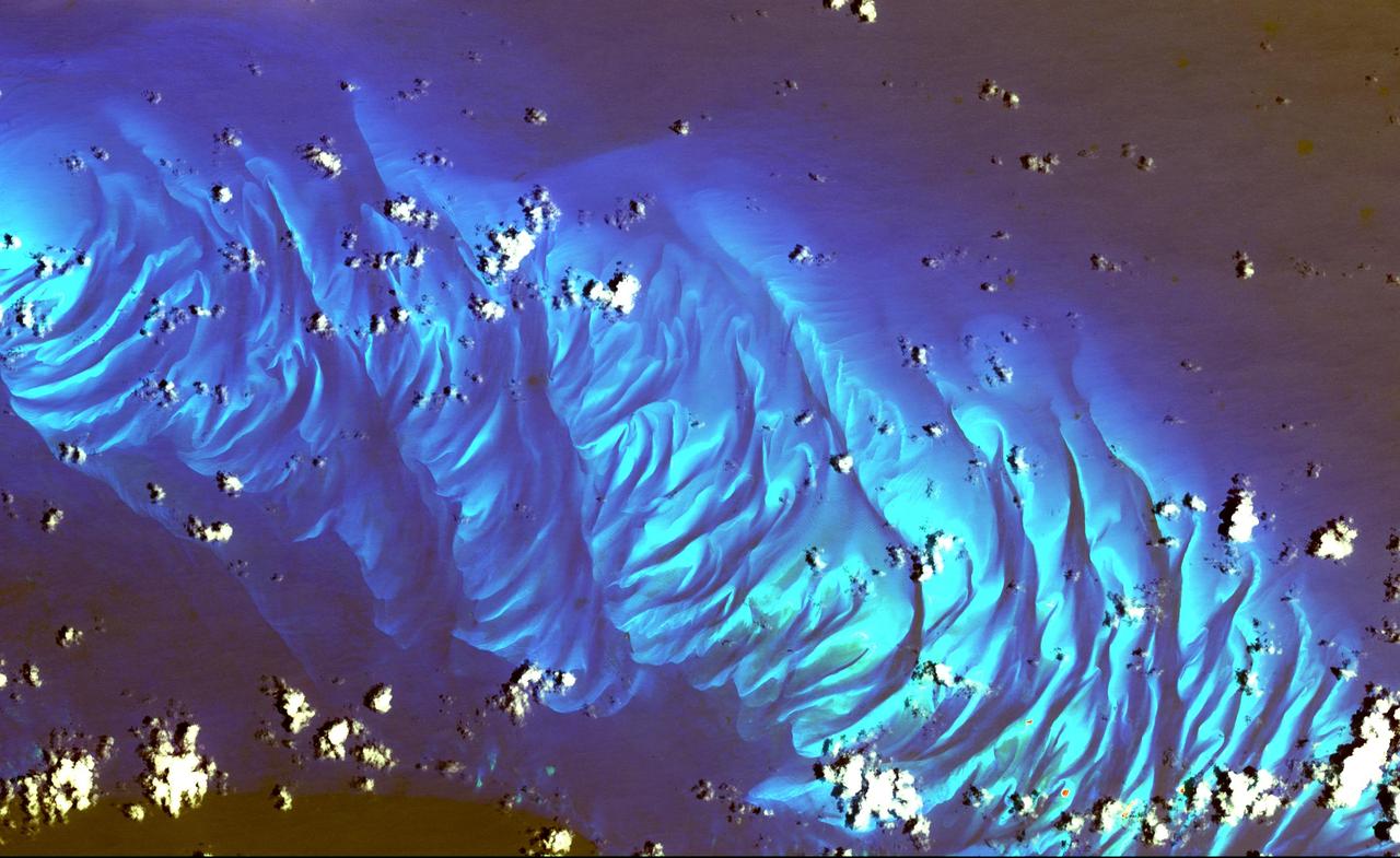
In this ASTER image the features that look like folded material are carbonate sand dunes in the shallow waters of Tarpum Bay, southwest of Eleuthera Island in the Bahamas. The sand making up the dunes comes from the erosion of limestone coral reefs, and has been shaped into dunes by ocean currents. This image was acquired on May 12, 2002 by the Advanced Spaceborne Thermal Emission and Reflection Radiometer (ASTER) on NASA's Terra satellite. With its 14 spectral bands from the visible to the thermal infrared wavelength region, and its high spatial resolution of 15 to 90 meters (about 50 to 300 feet), ASTER images Earth to map and monitor the changing surface of our planet. http://photojournal.jpl.nasa.gov/catalog/PIA03877
Space Systems/LORAL employees inspect solar panels for the GOES-K weather satellite in the Astrotech facility at Titusville, Fla., as they begin final testing of the imaging system, communications and power systems of the spacecraft. The GOES-K is the third spacecraft to be launched in the new advanced series of geostationary weather satellites for the National Oceanic and Atmospheric Administration (NOAA). The GOES-K is built for NASA and NOAA by Space Systems/LORAL of Palo Alto, Calif. The launch of the satellite from Launch Pad 36B at Cape Canaveral Air Station on an Atlas 1 rocket (AC-79) is currently planned for Apr. 24 at the opening of a launch window which extends from 1:56 to 3:19 a.m. EDT
CAPE CANAVERAL, Fla. – At the Astrotech Space Operations facility in Titusville, Fla., preparations are under way to remove the protective wrapping from the NASA's GOES-P meteorological satellite, secured on a Ransome table. GOES-P, the latest Geostationary Operational Environmental Satellite, was developed by NASA for the National Oceanic and Atmospheric Administration, or NOAA. GOES-P is designed to watch for storm development and observed current weather conditions on Earth. Launch of GOES-P is targeted for no earlier than March 1 from Launch Complex 37 aboard a United Launch Alliance Delta IV rocket. For information on GOES-P, visit http://goespoes.gsfc.nasa.gov/goes/spacecraft/n_p_spacecraft.html. Photo credit: NASA/Amanda Diller
Cape Horn is the southernmost point of the Tierra Del Fuego archipelago of Southern Chile, and marks the northern boundary of the Drake Passage where the Atlantic and Pacific Oceans meet. For decades after its 1616 discovery, it was a milestone for the clipper route by which sailing ships carried trade around the world (Wikipedia). Unfortunately, it was also a graveyard for sailing ships due to strong winds, large waves, strong currents, and icebergs. The 1914 opening of the Panama Canal greatly reduced the need for ships to traverse this dangerous passage. The image was acquired December 20, 2009, covers an area of 28.3 by 36.0 kilometers, and is located at 56 degrees south, 67.3 degrees west. https://photojournal.jpl.nasa.gov/catalog/PIA23118
VANDENBERG AIR FORCE BASE, CALIF. - Inside the NASA spacecraft processing hangar 1610 located on North Vandenberg Air Force Base in California, Lockheed Martin workers maneuver the Boeing Delta II payload attach fitting onto a connecting ring on the floor. The National Oceanic and Atmospheric Administration (NOAA-N) spacecraft, in the background, will then be mated to the payload attach fitting. Launch of NOAA-N aboard the Boeing Delta II rocket is currently scheduled for May 11, 2005. NOAA-N is the fourth in the series of support dedicated microwave instruments for the generation of temperature, moisture, surface, and hydrological products in cloudy regions where visible and infrared (IR) instruments have decreased capability.
VANDENBERG AIR FORCE BASE, CALIF. - Inside the NASA spacecraft processing hangar 1610 located on North Vandenberg Air Force Base in California, the National Oceanic and Atmospheric Administration (NOAA-N) spacecraft is undergoing testing. The testing includes a the Spacecraft Electrical Performance Test, battery conditioning, a Solar Array Illumination Telemetry Test, final instrument inspections and closeouts for flight. Launch of NOAA-N aboard the Boeing Delta II rocket is currently scheduled for May 11, 2005. NOAA-N is the fourth in the series of support dedicated microwave instruments for the generation of temperature, moisture, surface, and hydrological products in cloudy regions where visible and infrared (IR) instruments have decreased capability.
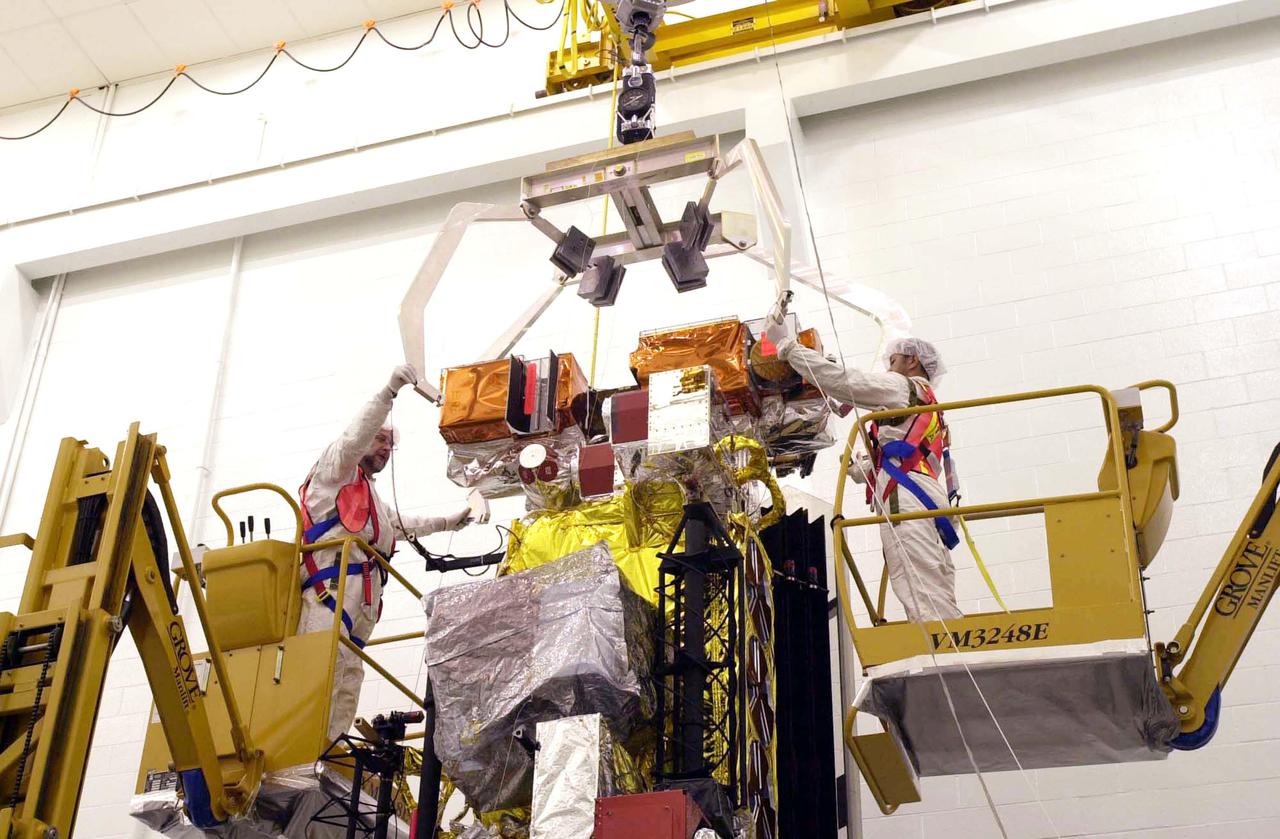
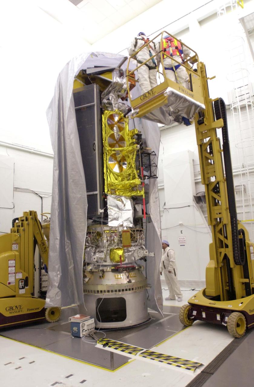
VANDENBERG AIR FORCE BASE, CALIF. - Inside the NASA spacecraft processing hangar 1610 located on North Vandenberg Air Force Base in California, Lockheed Martin workers attach a crane to move the National Oceanic and Atmospheric Administration (NOAA-N) spacecraft. NOAA-N will be lifted and mated to the Boeing Delta II payload attach fitting. Launch of NOAA-N aboard the Boeing Delta II rocket is currently scheduled for May 11, 2005. NOAA-N is the fourth in the series of support dedicated microwave instruments for the generation of temperature, moisture, surface, and hydrological products in cloudy regions where visible and infrared (IR) instruments have decreased capability.
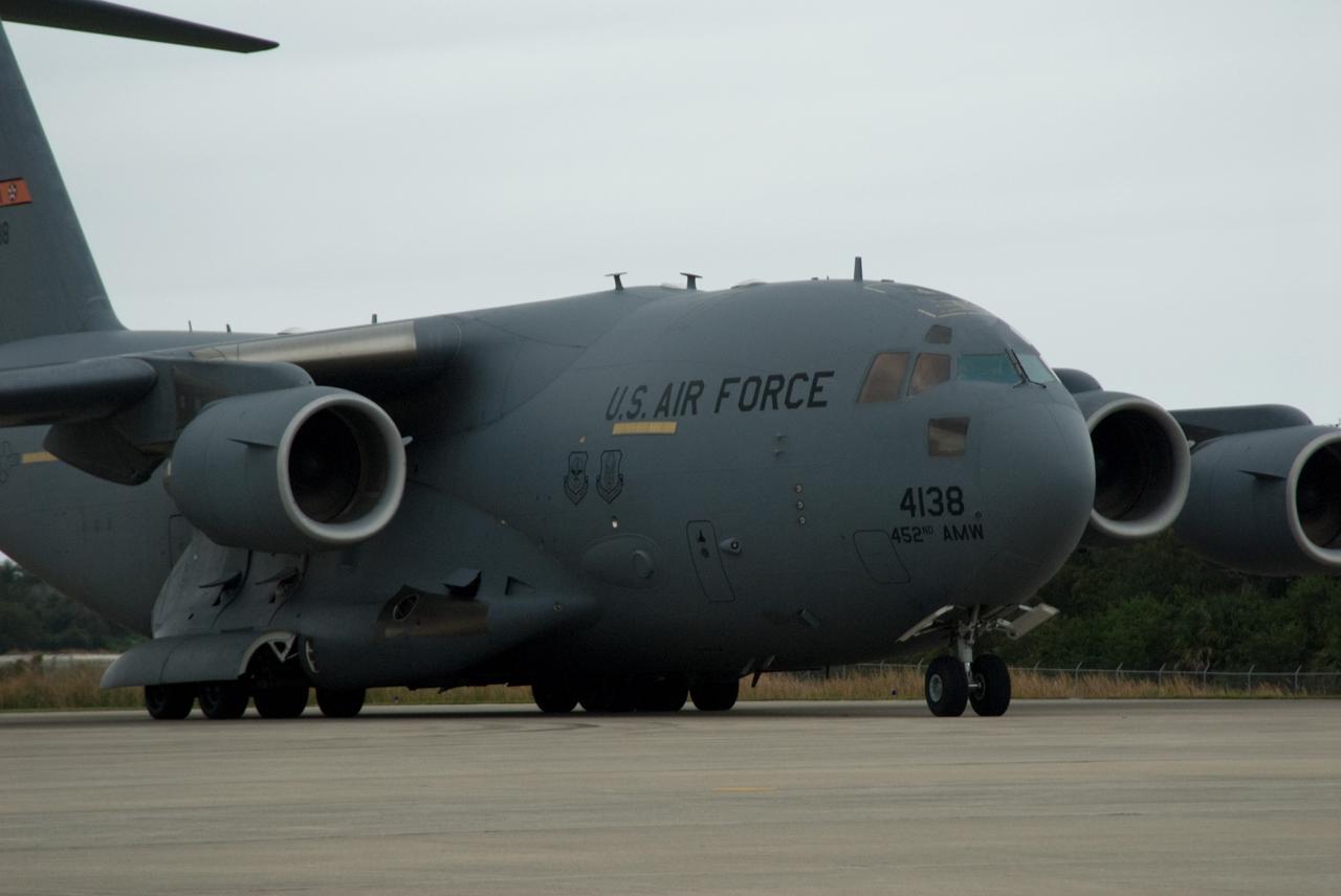
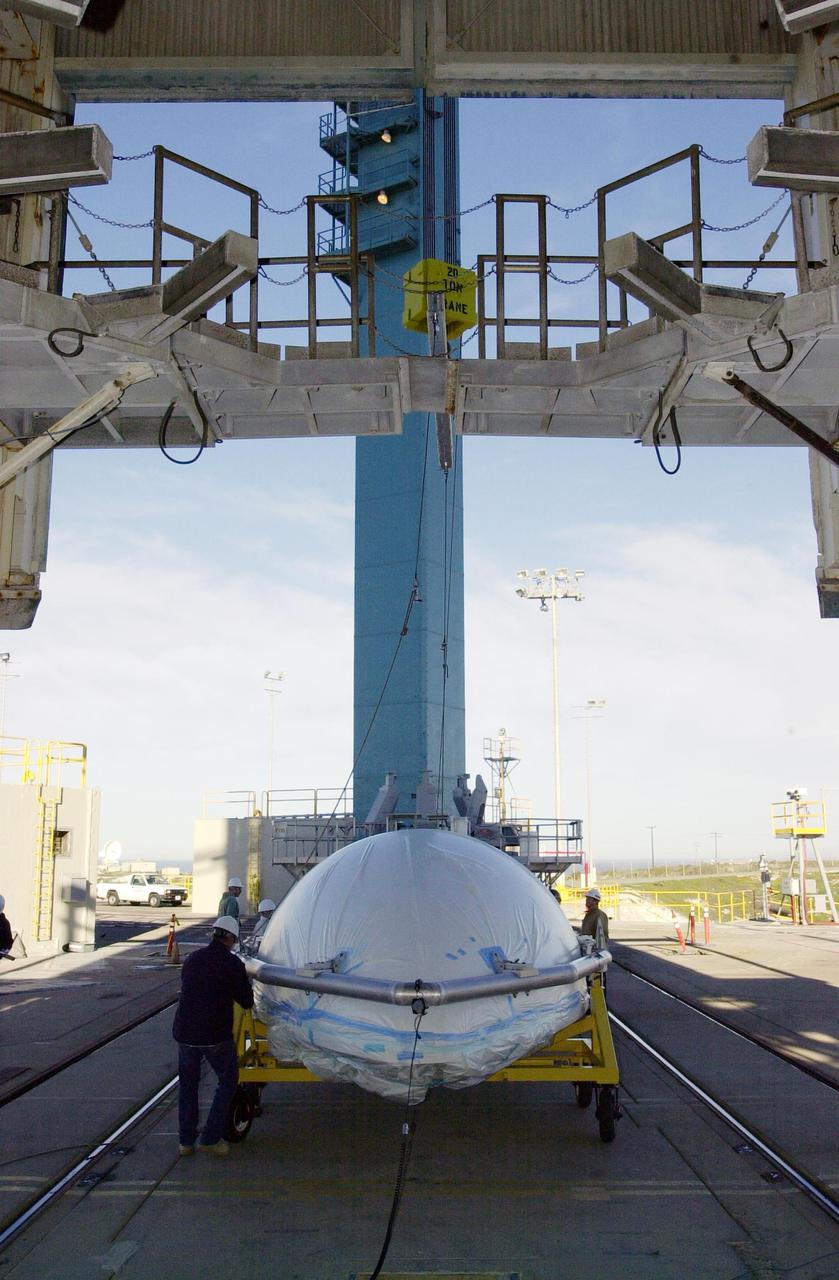
CAPE CANAVERAL, Fla. – NASA's GOES-P meteorological satellite is delivered to the Shuttle Landing Facility at NASA's Kennedy Space Center in Florida aboard a U.S. Air Force C-17 aircraft. GOES-P, the latest Geostationary Operational Environmental Satellite, was developed by NASA for the National Oceanic and Atmospheric Administration, or NOAA. GOES-P is designed to watch for storm development and observed current weather conditions on Earth. Launch of GOES-P is targeted for no earlier than Feb. 25, 2010, from Launch Complex 37 aboard a United Launch Alliance Delta IV rocket. For information on GOES-P, visit http://goespoes.gsfc.nasa.gov/goes/spacecraft/n_p_spacecraft.html. Photo credit: NASA/Amanda Diller
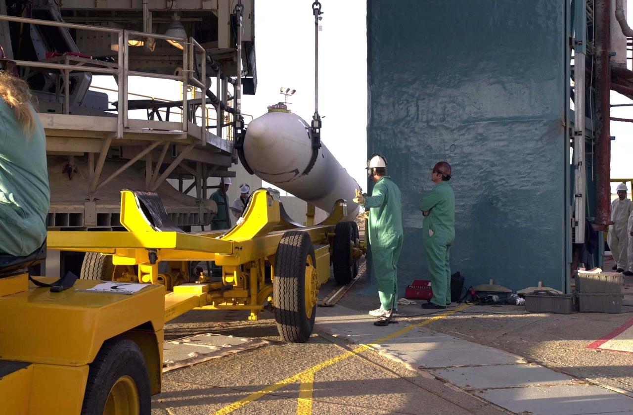
VANDENBERG AIR FORCE BASE, CALIF. - The first stage of a Boeing Delta II rocket is in the launch service tower of Space Launch Complex 2 on Vandenberg Air Force Base in California. It will be mated with an interstage adapter and Solid Rocket Boosters for the launch of the National Oceanic and Atmospheric Administration (NOAA-N) spacecraft. Launch of NOAA-N aboard the Boeing Delta II rocket is currently scheduled for May 11, 2005. NOAA-N is the fourth in the series of support dedicated microwave instruments for the generation of temperature, moisture, surface, and hydrological products in cloudy regions where visible and infrared (IR) instruments have decreased capability.
VANDENBERG AIR FORCE BASE, CALIF. - Another Solid Rocket Booster arrives at Space Launch Complex 2 on Vandenberg Air Force Base in California. It will be mated with a Boeing Delta II rocket for the launch of the National Oceanic and Atmospheric Administration (NOAA-N) spacecraft. Launch of NOAA-N aboard the Boeing Delta II rocket is currently scheduled for May 11, 2005. NOAA-N is the fourth in the series of support dedicated microwave instruments for the generation of temperature, moisture, surface, and hydrological products in cloudy regions where visible and infrared (IR) instruments have decreased capability.
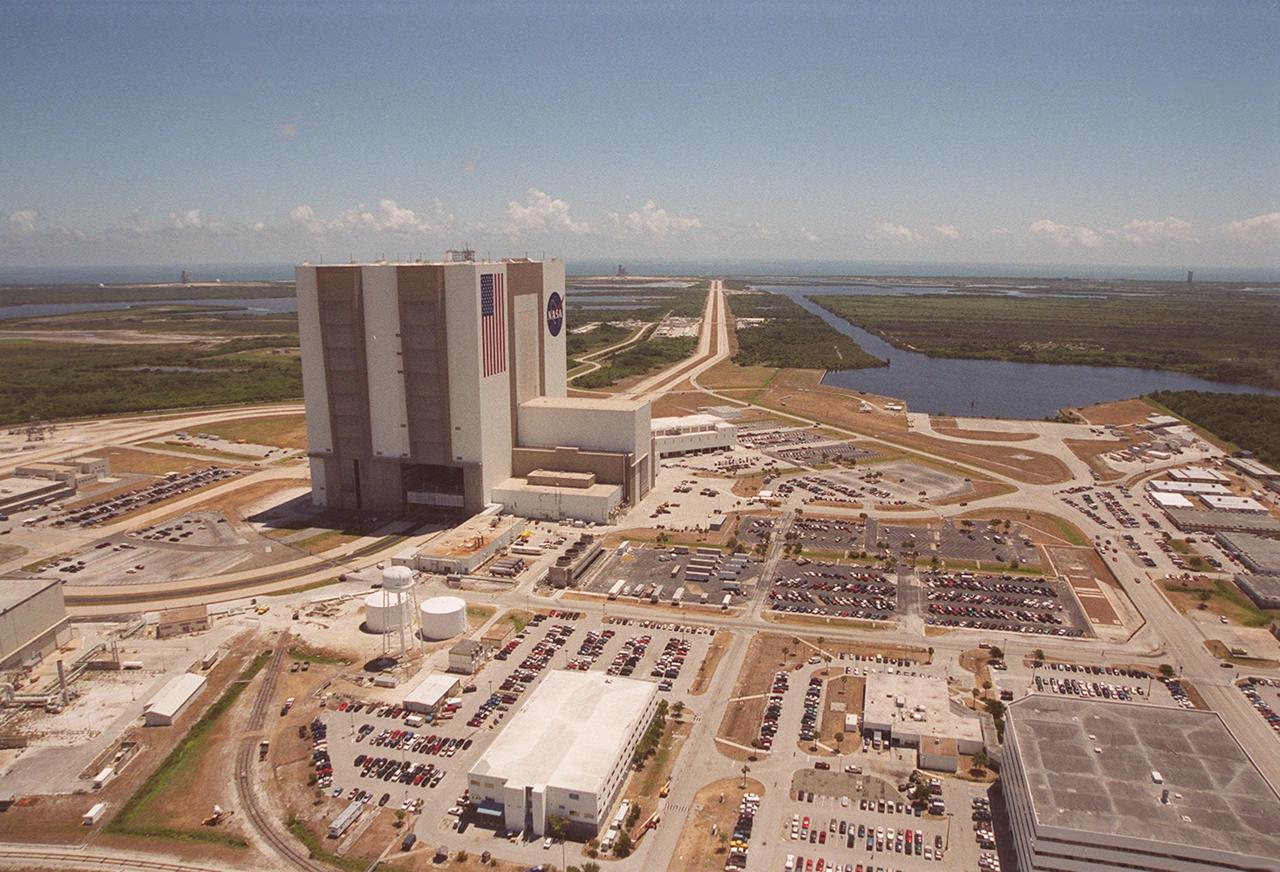
This aerial photo captures many of the facilities involved in Space Shuttle launches. At center is the Vehicle Assembly Building (VAB). The curved road on the near side is the newly restored crawlerway leading into the VAB high bay 2, where a mobile launcher platform/crawler-transporter currently sits. The road restoration and high bay 2 are part of KSC’s Safe Haven project, enabling the storage of orbiters during severe weather. The crawlerway also extends from the east side of the VAB out to the two Space Shuttle launch pads. In the distance is the Atlantic Ocean. To the right of the far crawlerway is the turn basin, into which ships tow the barge for offloading new external tanks from Louisiana
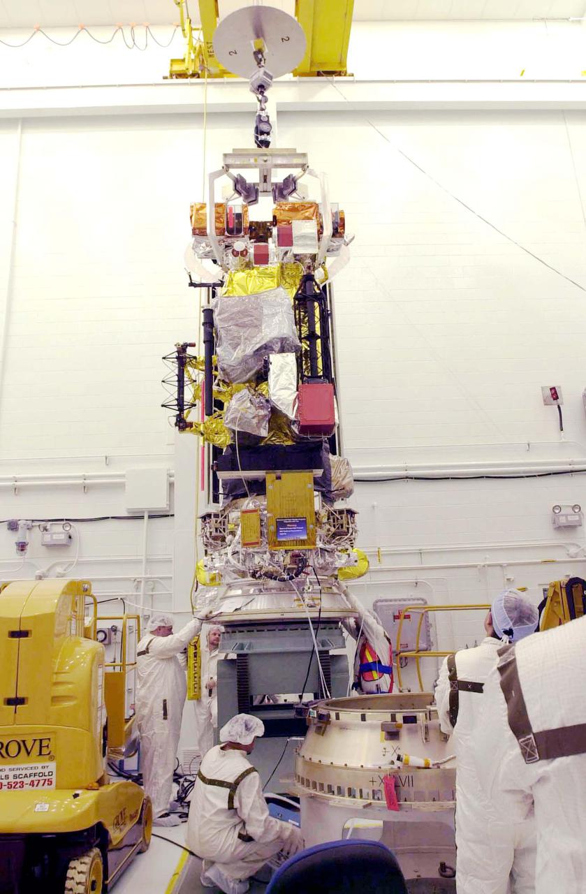
CAPE CANAVERAL, Fla. – At the Astrotech Space Operations facility in Titusville, Fla., spacecraft technicians rotate NASA's GOES-P meteorological satellite. GOES-P, the latest Geostationary Operational Environmental Satellite, was developed by NASA for the National Oceanic and Atmospheric Administration, or NOAA. GOES-P is designed to watch for storm development and observed current weather conditions on Earth. Launch of GOES-P is targeted for no earlier than March 1 from Launch Complex 37 aboard a United Launch Alliance Delta IV rocket. For information on GOES-P, visit http://goespoes.gsfc.nasa.gov/goes/spacecraft/n_p_spacecraft.html. Photo credit: NASA/Amanda Diller
CAPE CANAVERAL, Fla. – At the Astrotech Space Operations facility in Titusville, Fla., NASA's GOES-P meteorological satellite is lifted toward a fueling stand. The spacecraft will be loaded with the propellant necessary for orbit maneuvers and the attitude control system. GOES-P, the latest Geostationary Operational Environmental Satellite, was developed by NASA for the National Oceanic and Atmospheric Administration, or NOAA. GOES-P is designed to watch for storm development and observed current weather conditions on Earth. Launch of GOES-P is targeted for March 1 from Launch Complex 37 aboard a United Launch Alliance Delta IV rocket. For information on GOES-P, visit http:__www.nasa.gov_mission_pages_GOES-P_main_index.html. Photo credit: NASA_Troy Cryder
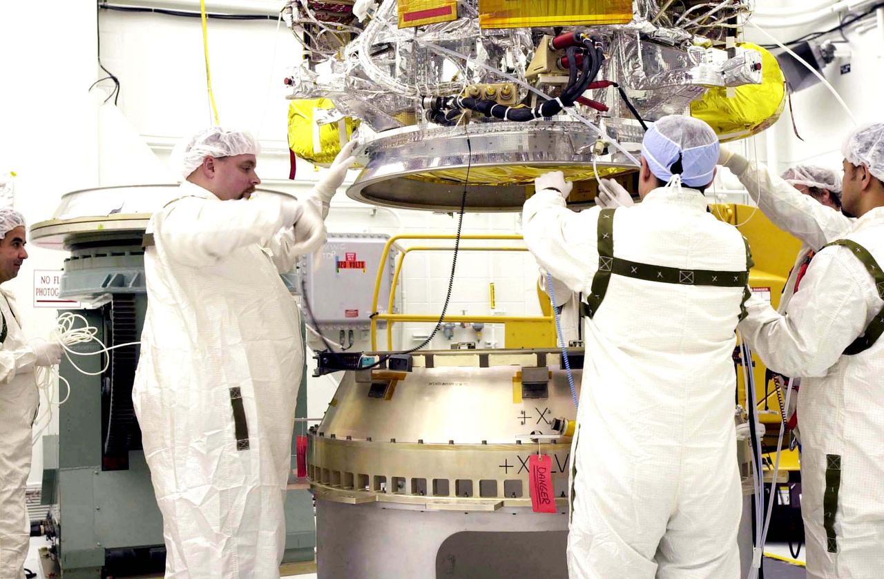
VANDENBERG AIR FORCE BASE, CALIF. - Inside the NASA spacecraft processing hangar 1610 located on North Vandenberg Air Force Base in California, Lockheed Martin workers help guide the National Oceanic and Atmospheric Administration (NOAA-N) spacecraft, above, onto the Boeing Delta II payload attach fitting below. Launch of NOAA-N aboard the Boeing Delta II rocket is currently scheduled for May 11, 2005. NOAA-N is the fourth in the series of support dedicated microwave instruments for the generation of temperature, moisture, surface, and hydrological products in cloudy regions where visible and infrared (IR) instruments have decreased capability.
CAPE CANAVERAL, Fla. – At the Astrotech Space Operations facility in Titusville, Fla., workers remove the transportation cover from NASA's newly arrived GOES-P meteorological satellite. GOES-P, the latest Geostationary Operational Environmental Satellite, was developed by NASA for the National Oceanic and Atmospheric Administration, or NOAA. GOES-P is designed to watch for storm development and observed current weather conditions on Earth. Launch of GOES-P is targeted for no earlier than Feb. 25, 2010, from Launch Complex 37 aboard a United Launch Alliance Delta IV rocket. For information on GOES-P, visit http://goespoes.gsfc.nasa.gov/goes/spacecraft/n_p_spacecraft.html. Photo credit: NASA/Glenn Benson
VANDENBERG AIR FORCE BASE, CALIF. - At Space Launch Complex 2 on Vandenberg Air Force Base in California, one of three Solid Rocket Boosters is lifted alongside the first stage of a Boeing Delta II rocket for mating. The Boeing Delta II will launch the National Oceanic and Atmospheric Administration (NOAA-N) spacecraft. Launch of NOAA-N aboard the Boeing Delta II rocket is currently scheduled for May 11, 2005. NOAA-N is the fourth in the series of support dedicated microwave instruments for the generation of temperature, moisture, surface, and hydrological products in cloudy regions where visible and infrared (IR) instruments have decreased capability.
VANDENBERG AIR FORCE BASE, CALIF. - On Space Launch Complex 2 at Vandenberg Air Force Base in California, one of the two fairing sections for the National Oceanic and Atmospheric Administration (NOAA-N) spacecraft is being lifted up into the launch service tower. The fairing will be placed around the spacecraft to protect it during launch. NOAA-N is the fourth in the series of support dedicated microwave instruments for the generation of temperature, moisture, surface, and hydrological products in cloudy regions where visible and infrared (IR) instruments have decreased capability. Launch aboard a Boeing Delta II rocket is currently scheduled for no earlier than May 11, 2005.
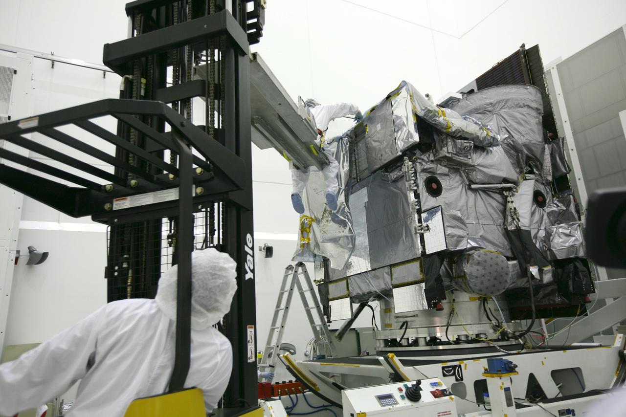
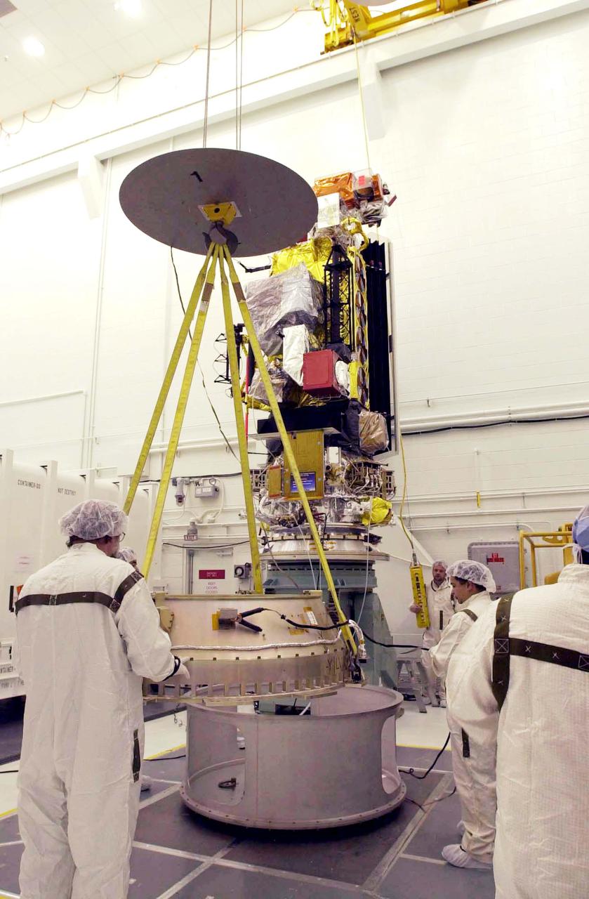
VANDENBERG AIR FORCE BASE, CALIF. - Inside the NASA spacecraft processing hangar 1610 located on North Vandenberg Air Force Base in California, Lockheed Martin workers attach a crane to lift the National Oceanic and Atmospheric Administration (NOAA-N) spacecraft from its shipping container and move it to an assembly and test stand. It will be mated to the Delta II payload attach fitting. Launch of NOAA-N aboard the Boeing Delta II rocket is currently scheduled for May 11, 2005. NOAA-N is the fourth in the series of support dedicated microwave instruments for the generation of temperature, moisture, surface, and hydrological products in cloudy regions where visible and infrared (IR) instruments have decreased capability.
VANDENBERG AIR FORCE BASE, CALIF. - Inside the NASA spacecraft processing hangar 1610 located on North Vandenberg Air Force Base in California, the National Oceanic and Atmospheric Administration (NOAA-N) spacecraft is undergoing testing. The testing includes a the Spacecraft Electrical Performance Test, battery conditioning, a Solar Array Illumination Telemetry Test, final instrument inspections and closeouts for flight. Launch of NOAA-N aboard the Boeing Delta II rocket is currently scheduled for May 11, 2005. NOAA-N is the fourth in the series of support dedicated microwave instruments for the generation of temperature, moisture, surface, and hydrological products in cloudy regions where visible and infrared (IR) instruments have decreased capability.