
STS035-12-005 (2-10 Dec 1990) --- During STS-35, middeck stowage volume G and a contingency water container (CWC) were utilized to remedy a problem onboard Columbia, Orbiter Vehicle (OV) 102. A hose connecting OV-102's waste water system to the CWC was used in order to bypass a suspected clog in the line from the waste water tank to the exit nozzle. On flight day seven, Pilot Guy S. Gardner carried out an inflight maintenance (IFM) procedure by connecting a spare hose from the line to the container. The CWC is a rubber-lined duffle bag that holds about 95 pounds of water and is used in situations where water cannot be dumped overboard normally.
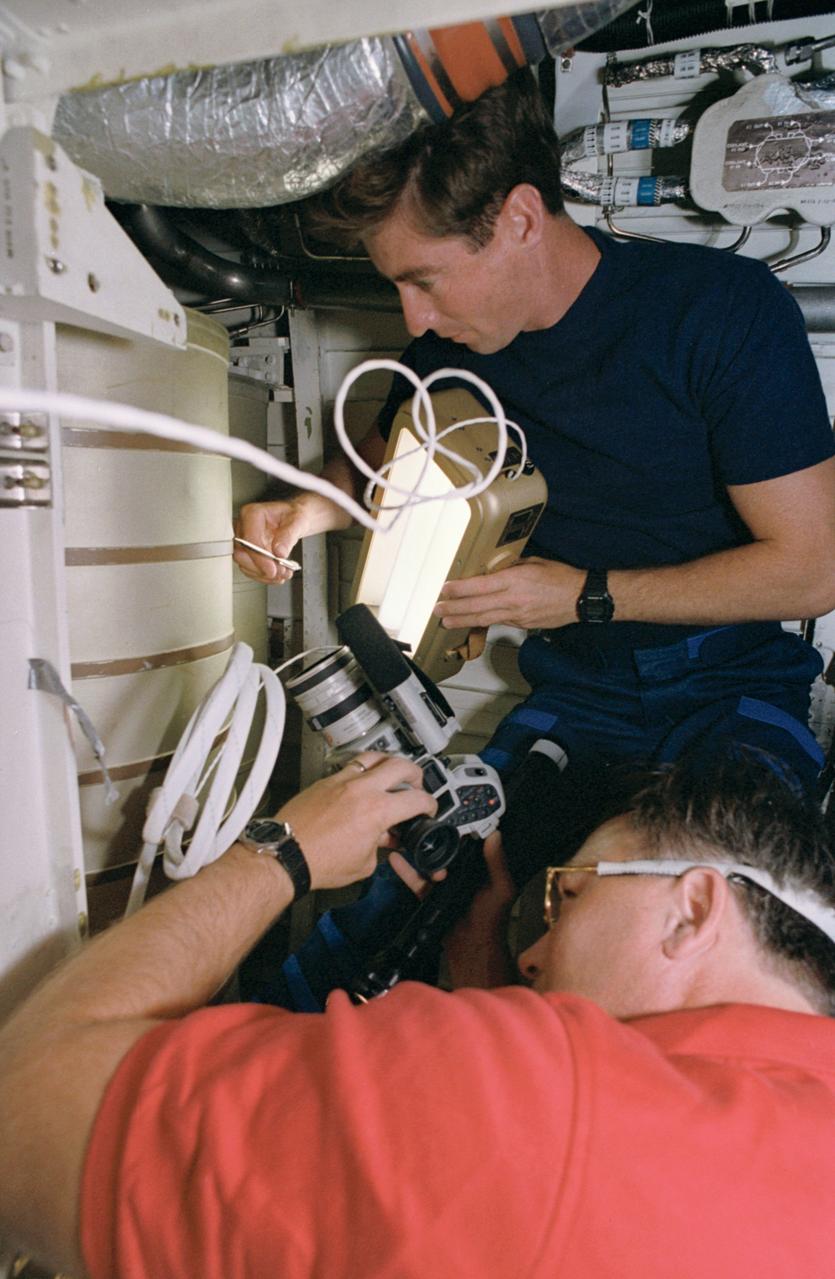
STS055-39-036 (26 April-6 May 1993) --- Astronaut Terence T. (Tom) Henricks, pilot, uses a spotlight and pen to point out a possible problem area on a waste water tank in the bilge area below Columbia's middeck. Astronaut Jerry L. Ross, payload commander, records the activity with a camera.

ISS047e013845 (03/22/2016) --- ESA (European Space Agency) astronaut Tim Peake works on the Water Processor Assembly (WPA) aboard the International Space Station. The WPA is is responsible for treating waste water aboard the station for recycling back into potable water.

The Marshall Space Flight Center (MSFC) is responsible for designing and building the life support systems that will provide the crew of the International Space Station (ISS) a comfortable environment in which to live and work. Scientists and engineers at the MSFC are working together to provide the ISS with systems that are safe, efficient, and cost-effective. These compact and powerful systems are collectively called the Environmental Control and Life Support Systems, or simply, ECLSS. This photograph shows the development Water Processor located in two racks in the ECLSS test area at the Marshall Space Flight Center. Actual waste water, simulating Space Station waste, is generated and processed through the hardware to evaluate the performance of technologies in the flight Water Processor design.
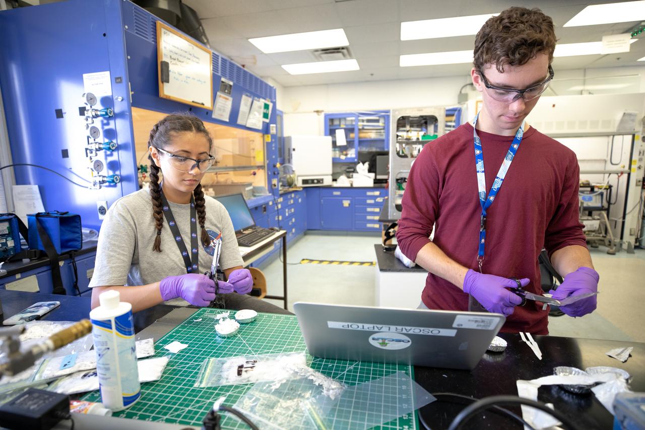
From left, interns Isabella Aviles and Patrick Follis at NASA’s Kennedy Space Center in Florida cut up different types of material for the agency’s Orbital Syngas Commodity Augmentation Reactor, or OSCAR, to use as a trash simulant during microgravity testing. OSCAR is an Early Career Initiative project at the spaceport that studies technology to convert trash and human waste into useful gasses such as methane, hydrogen and carbon dioxide. By processing small pieces of trash in a high-temperature reactor, OSCAR is advancing new and innovative technology for managing waste in space. OSCAR would reduce the amount of space needed for waste storage within a spacecraft, turn some waste into gasses that have energy storage and life support applications, recover water from trash and ensure waste is no longer biologically active. A prototype has been developed, and a team of Kennedy employees are in the process of constructing a new rig for suborbital flight testing.
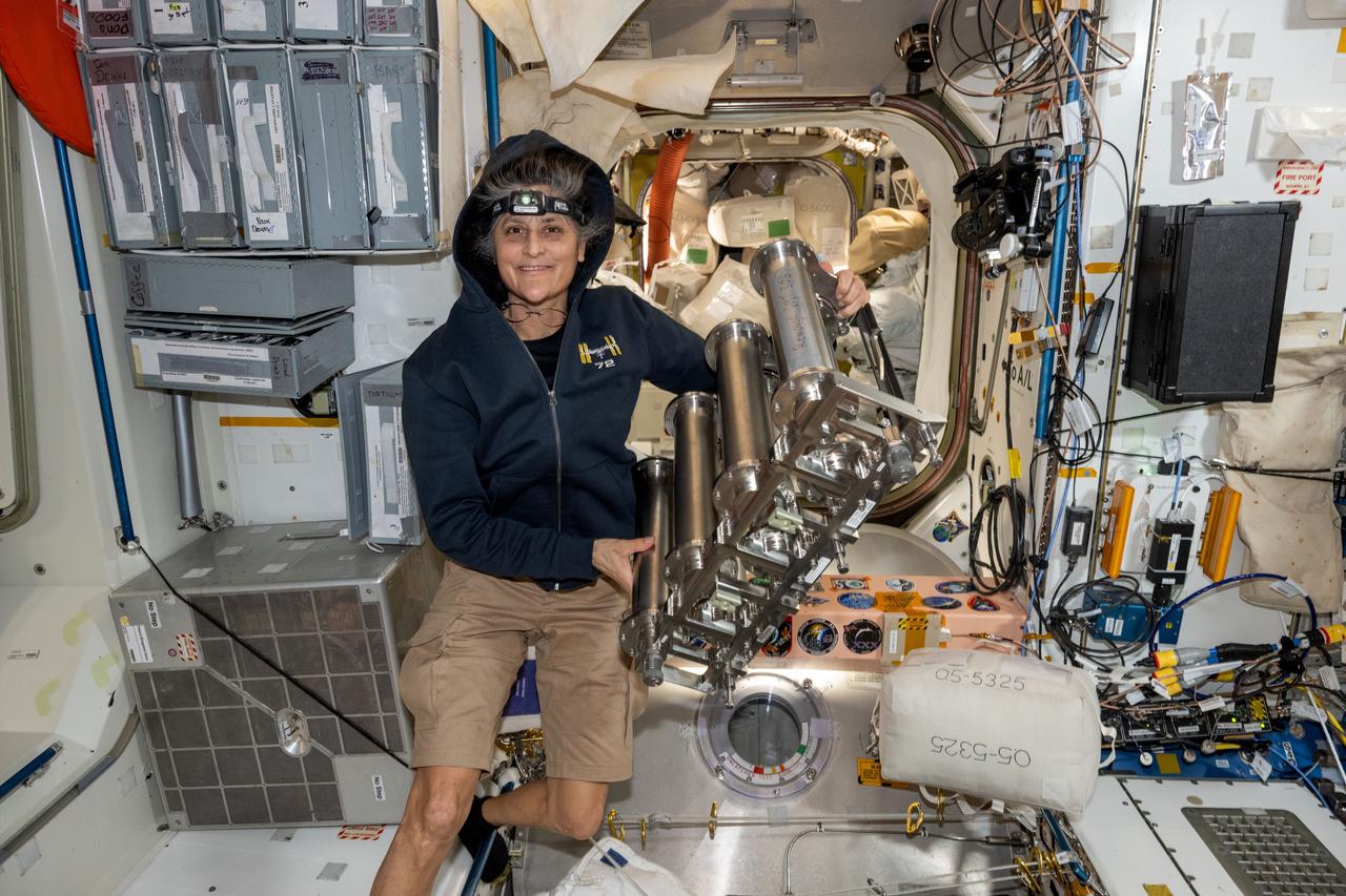
iss072e143163 (Nov. 1, 2024) --- NASA astronaut and Expedition 72 Commander Suni Williams replaces particulate filters on the water recovery system, a component of the Tranquility module's waste and hygiene compartment, the International Space Station's bathroom.
CAPE CANAVERAL, Fla. – This photo shows the Water Recovery System's rack 2, that will be delivered to the International Space Station aboard space shuttle Endeavour on the STS-126 mission. Its primary purpose is to process urine and waster water so that Waste Recovery System's rack 1 can perform the final cleanup. The two units of the Water Recovery System are designed to provide drinking-quality water through the reclamation of wastewater, including urine and hygiene wastes. The water that’s produced will be used to support the crew and work aboard the station. Endeavour and its crew of seven are scheduled to lift off at 7:55 p.m. Nov. 14 for the 15-day STS-126 mission. Photo credit: NASA
ISS043E128431 (04/22/2015) --- The International Space Station employs one of the most complex water recycling systems ever designed, reclaiming waste water from astronauts and the environment and turning it into potable water. NASA astronaut Scott Kelly tweeted out this image of part of the innovative device with this remark: " Recycle Good to the last drop! Making pee potable and turning it into coffee on @space station. #NoPlaceLikeHome"
ISS043E128431 (04/22/2015) --- The International Space Station employs one of the most complex water recycling systems ever designed, reclaiming waste water from astronauts and the environment and turning it into potable water. NASA astronaut Scott Kelly tweeted out this image of part of the innovative device with this remark: " Recycle Good to the last drop! Making pee potable and turning it into coffee on @space station. #NoPlaceLikeHome"
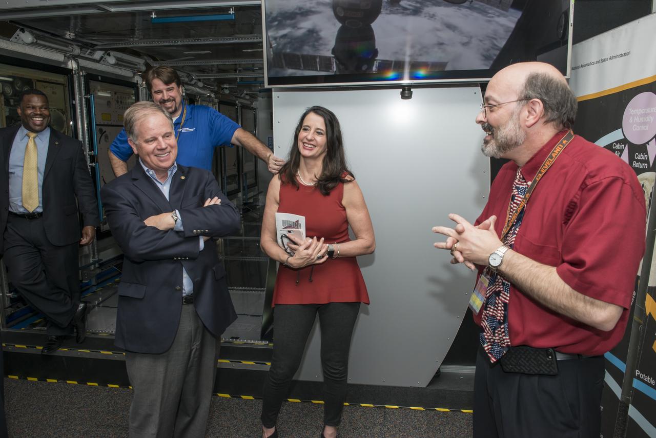
Senator Doug Jones (D-Al.) and wife Louise are presented an overview of the Environmental Control and Life Support System (ECLSS) which was developed at Marshall Space flight Center. Marshall engineer Keith Parrish explains the steps in converting waste fluids generated on the International Space Station (ISS) into purified drinking water.

Senator Doug Jones (D-Al.) and wife Louise are presented an overview of the Environmental Control and Life Support System (ECLSS) which was developed at Marshall Space flight Center. Marshall engineer Keith Parrish explains the steps in converting waste fluids generated on the International Space Station (ISS) into purified drinking water.

iss071e077443 (May 10, 2024) --- NASA astronaut and Expedition 71 Flight Engineer Tracy C. Dyson works in the Tranquility module replacing hardware that supports the water recovery system which is part of the International Space Station’s Waste and Hygiene compartment, or bathroom.

CAPE CANAVERAL, Fla. – This photo shows the waste and hygiene compartment that will be delivered to the International Space Station aboard space shuttle Endeavour on the STS-126 mission. The Russian-built toilet system provides the crew with a second facility on the station, located in the Destiny lab. The unit separately channels liquid and solid waste. While the solid waste goes to a holding tank, a new pair of processing units that Endeavour also will deliver on this mission are set to begin a unique recycling program -- turning crew members’ urine into potable water. Space shuttle Endeavour and its crew of seven are scheduled to lift off at 7:55 p.m. Nov. 14 for the 15-day STS-126 mission. Photo credit: NASA
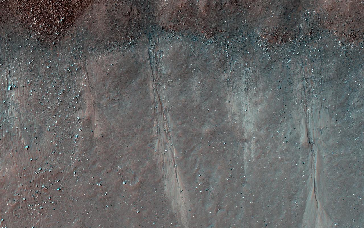
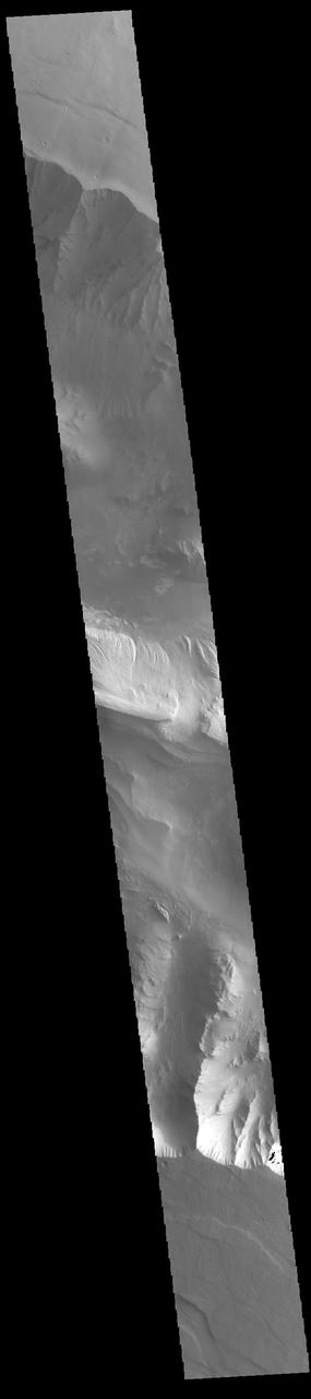
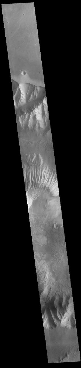
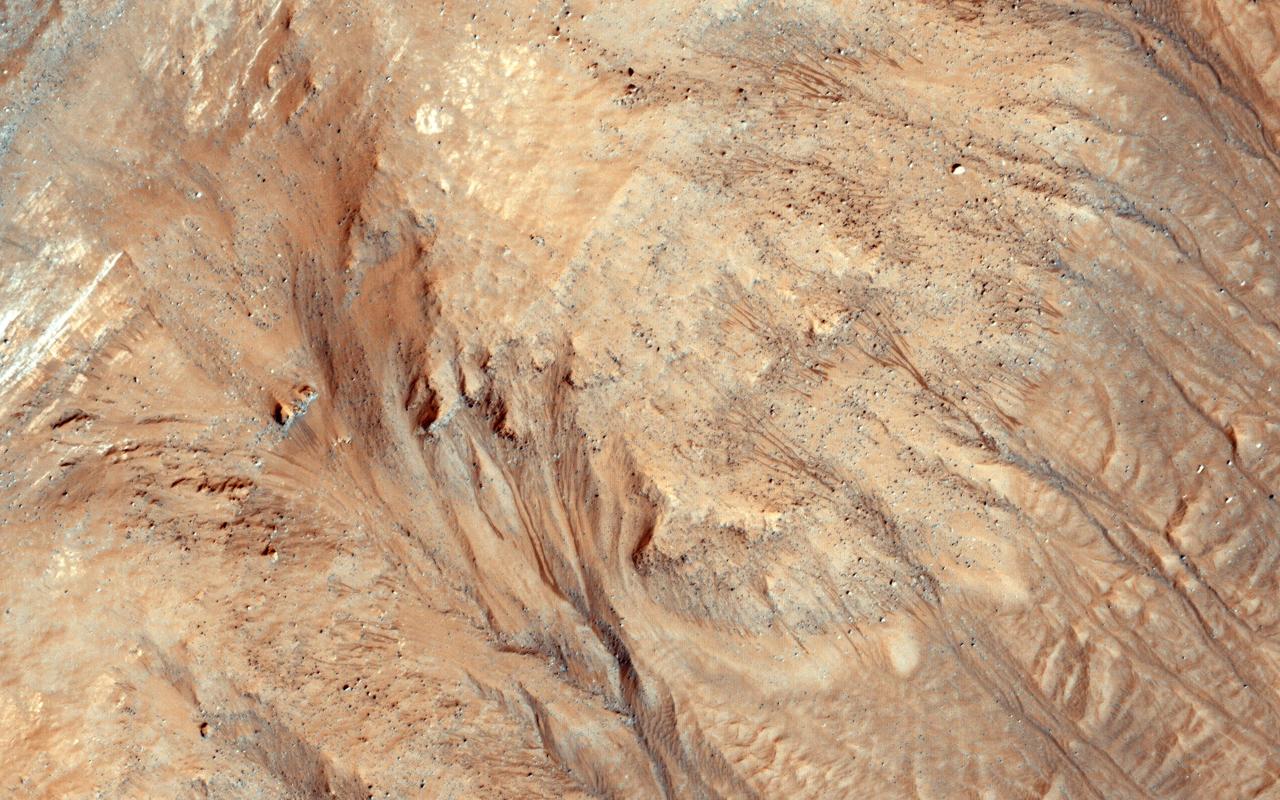
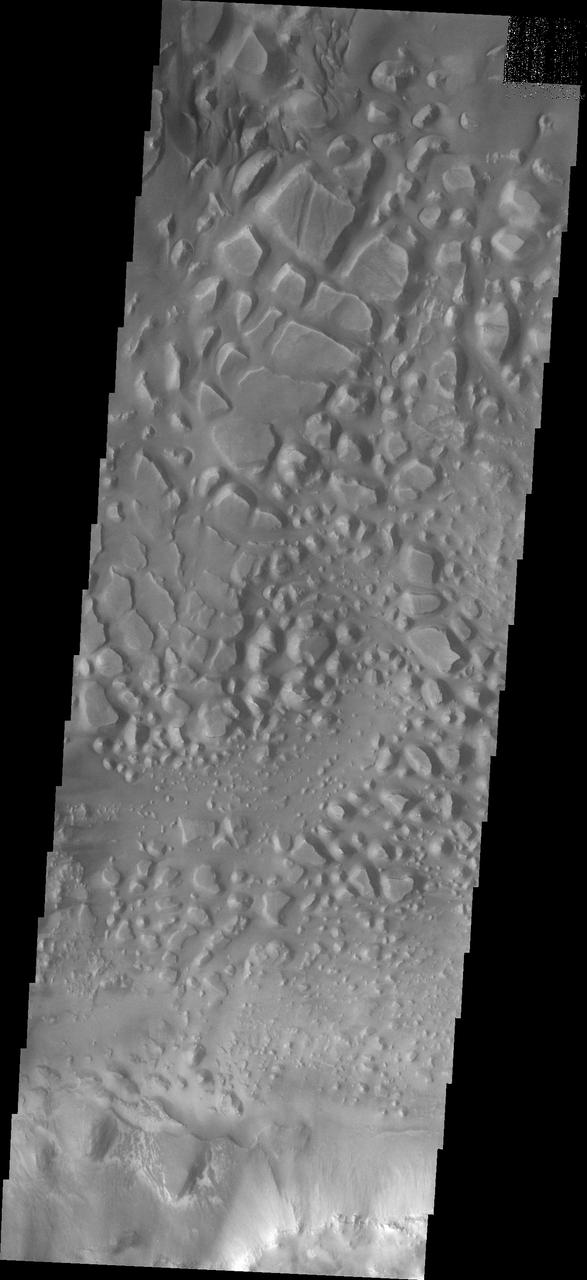
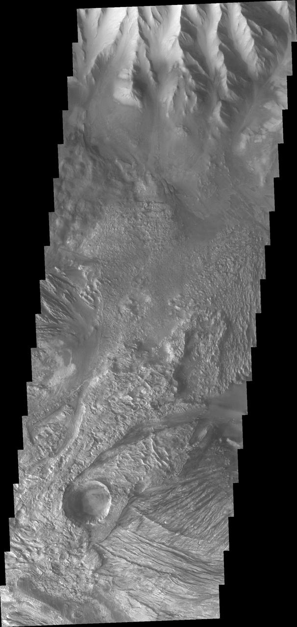
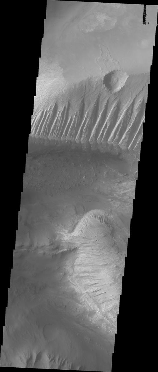
The formation of gullies on Martian slopes is still under debate. Potential mechanisms include the melting of surface water ice, groundwater outbursts, or dry mass wasting processes (landslides). This image shows several shallow gully channels with associated debris aprons emanating from a buried layer on the interior of a crater wall. Also visible are many boulders of varying sizes along the wall, with several exhibiting clear tracks from their journey downslope. These tracks can be used to better understand the mass wasting environment on the hill slope and whether there is any connection between the boulders and the gullies. https://photojournal.jpl.nasa.gov/catalog/PIA25554
CAPE CANAVERAL, Fla. – This photo shows the Water Recovery System's rack 1 that will be delivered to the International Space Station aboard space shuttle Endeavour on the STS-126 mission. The two units of the Water Recovery System are designed to provide drinking-quality water through the reclamation of wastewater, including urine and hygiene wastes. The water that’s produced will be used to support the crew and work aboard the station. Endeavour and its crew of seven are scheduled to lift off at 7:55 p.m. Nov. 14 for the 15-day STS-126 mission. Photo credit: NASA
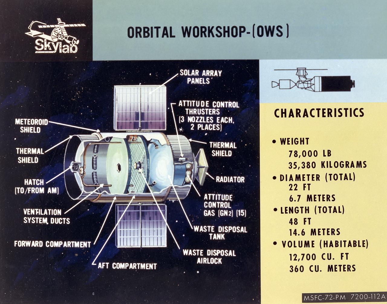
This cutaway illustration shows the characteristics and basic elements of the Skylab Orbiter Workshop (OWS). The OWS was divided into two major compartments. The lower level provided crew accommodations for sleeping, food preparation and consumption, hygiene, waste processing and disposal, and performance of certain experiments. The upper level consisted of a large work area and housed water storage tanks, a food freezer, storage vaults for film, scientific airlocks, mobility and stability experiment equipment, and other experimental equipment. The compartment below the crew quarters was a container for liquid and solid waste and trash accumulated throughout the mission. A solar array, consisting of two wings covered on one side with solar cells, was mounted outside the workshop to generate electrical power to augment the power generated by another solar array mounted on the solar observatory. Thrusters were provided at one end of the workshop for short-term control of the attitude of the space station.
ISS030-E-032750 (11 Jan. 2012) --- NASA astronaut Dan Burbank, Expedition 30 flight commander, performs the Waste and Hygiene Compartment (WHC) yearly maintenance in the Tranquility node of the International Space Station. The maintenance included removing and replacing the urine hydraulic components which include urine lines, urine valve block and urine pressure sensors, and removing and replacing the Flush Water Tank Pressure Sensor.
This photograph was taken during installation of floor grids on the upper and lower floors inside the Skylab Orbital Workshop at the McDornell Douglas plant at Huntington Beach, California. The OWS was divided into two major compartments. The lower level provided crew accommodations for sleeping, food preparation and consumption, hygiene, waste processing and disposal, and performance of certain experiments. The upper level consisted of a large work area and housed water storage tanks, a food freezer, storage vaults for film, scientific airlocks, mobility and stability experiment equipment, and other experimental equipment.
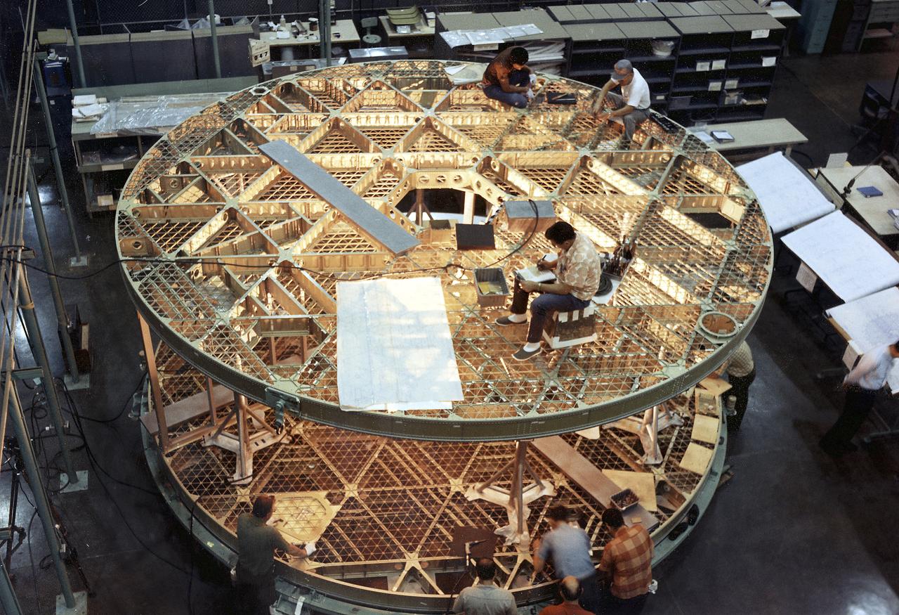
This photograph was taken during assembly of the bottom and upper floors of the Skylab Orbital Workshop (OWS). The OWS was divided into two major compartments. The lower level provided crew accommodations for sleeping, food preparation and consumption, hygiene, waste processing and disposal, and performance of certain experiments. The upper level consisted of a large work area and housed water storage tanks, a food freezer, storage vaults for film, scientific airlocks, mobility and stability experiment equipment, and other experimental equipment.
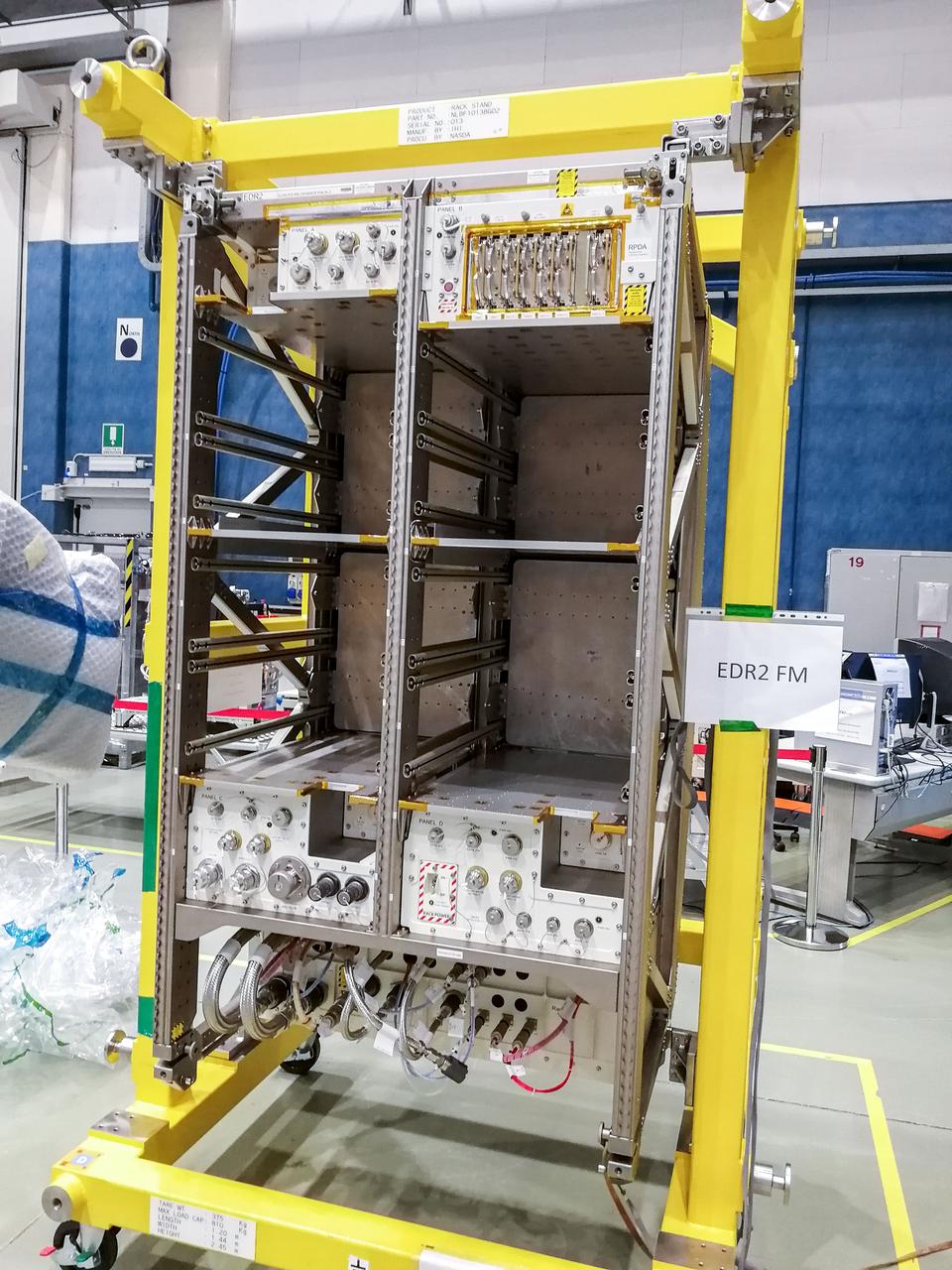
jsc2019e048243 (3/28/2019) — Preflight imagery of the EDR-2 Flight Model in its rack integration stand. The European Drawer Rack-2 (EDR-2) is an experiment support facility accommodated in the Columbus module. The rack provides general services to experiments, including power, data communication, water cooling, vacuum and venting/waste gas, nitrogen supply and structural interfaces.
CAPE CANAVERAL, Fla. – In the News Center at NASA's Kennedy Space Center in Florida, Bob Bagdigian (right) talks to the media about the Water Recovery System being delivered to the International Space Station on space shuttle Endeavour's STS-126 mission. The two units of the Water Recovery System are designed to provide drinking-quality water through the reclamation of wastewater, including urine and hygiene wastes. The water that’s produced will be used to support the crew and work aboard the station. STS-126 is the 124th space shuttle flight and the 27th flight to the International Space Station. The mission will feature four spacewalks and work that will prepare the space station to house six crew members for long- duration missions. Liftoff is scheduled for 7:55 p.m. EST Nov. 14. Photo credit: NASA/Dimitri Gerondidakis
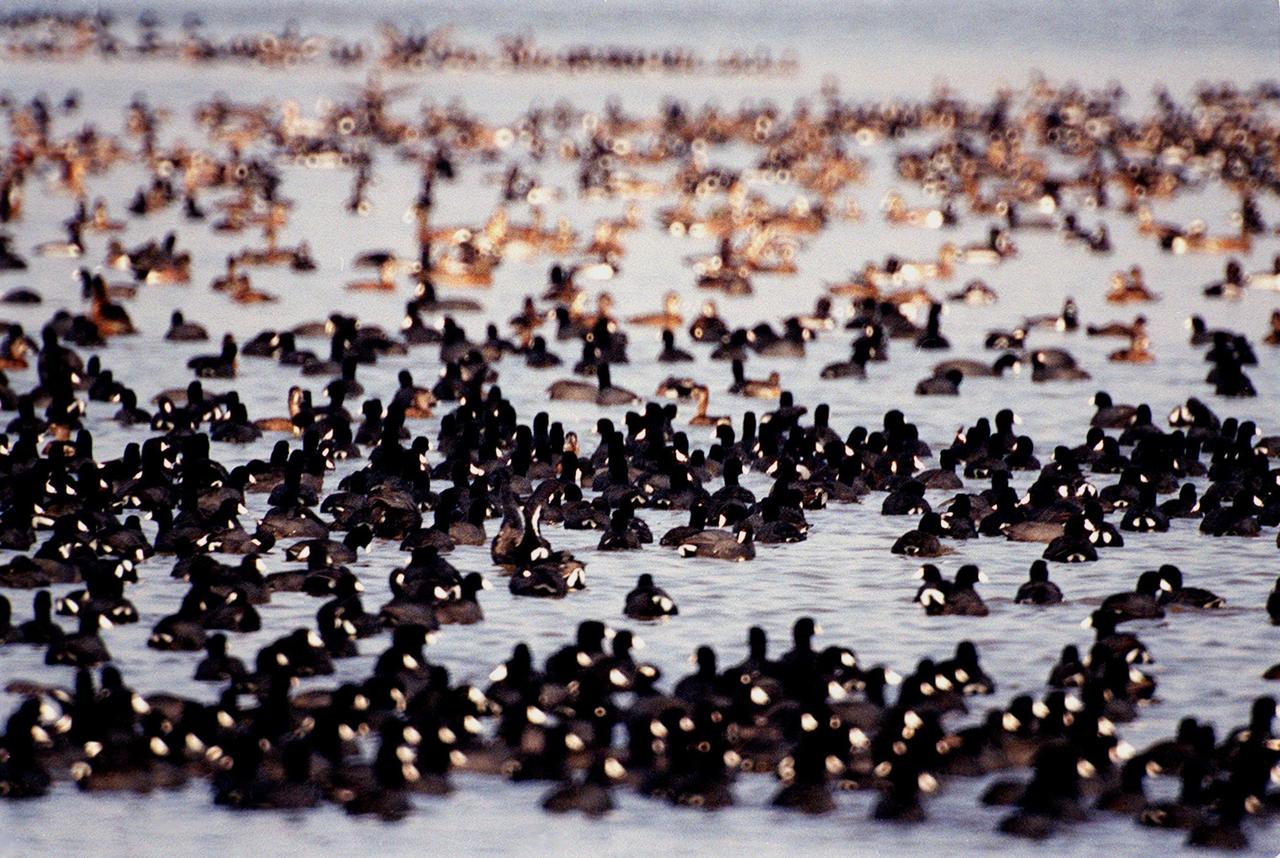
KENNEDY SPACE CENTER, FLA. - The waters of the Merritt Island National Wildlife Refuge, which shares a boundary with Kennedy Space Center, attract coots, ducks, herons and other water birds as shown here. Coots are readily identified by their slate-gray bodies and conspicuous white bill. They inhabit open ponds and marshes from southern Canada to northern South America. Excellent swimmers and divers, they eat various aquatic plants, but also feed on seeds grass and waste grain on land. The 92,000-acre refuge is a habitat for more than 330 species of birds, 31 mammals, 117 fishes and 65 amphibians and reptiles. The marshes and open water of the refuge provide wintering areas for 23 species of migratory waterfowl, as well as a year-round home for great blue herons, great egrets, wood storks, cormorants, brown pelicans and other species of marsh and shore birds.

KENNEDY SPACE CENTER, FLA. - The waters of the Merritt Island National Wildlife Refuge, which shares a boundary with Kennedy Space Center, attract coots, ducks, herons and other water birds as shown here. Coots are readily identified by their slate-gray bodies and conspicuous white bill. They inhabit open ponds and marshes from southern Canada to northern South America. Excellent swimmers and divers, they eat various aquatic plants, but also feed on seeds grass and waste grain on land. The 92,000-acre refuge is a habitat for more than 330 species of birds, 31 mammals, 117 fishes and 65 amphibians and reptiles. The marshes and open water of the refuge provide wintering areas for 23 species of migratory waterfowl, as well as a year-round home for great blue herons, great egrets, wood storks, cormorants, brown pelicans and other species of marsh and shore birds.
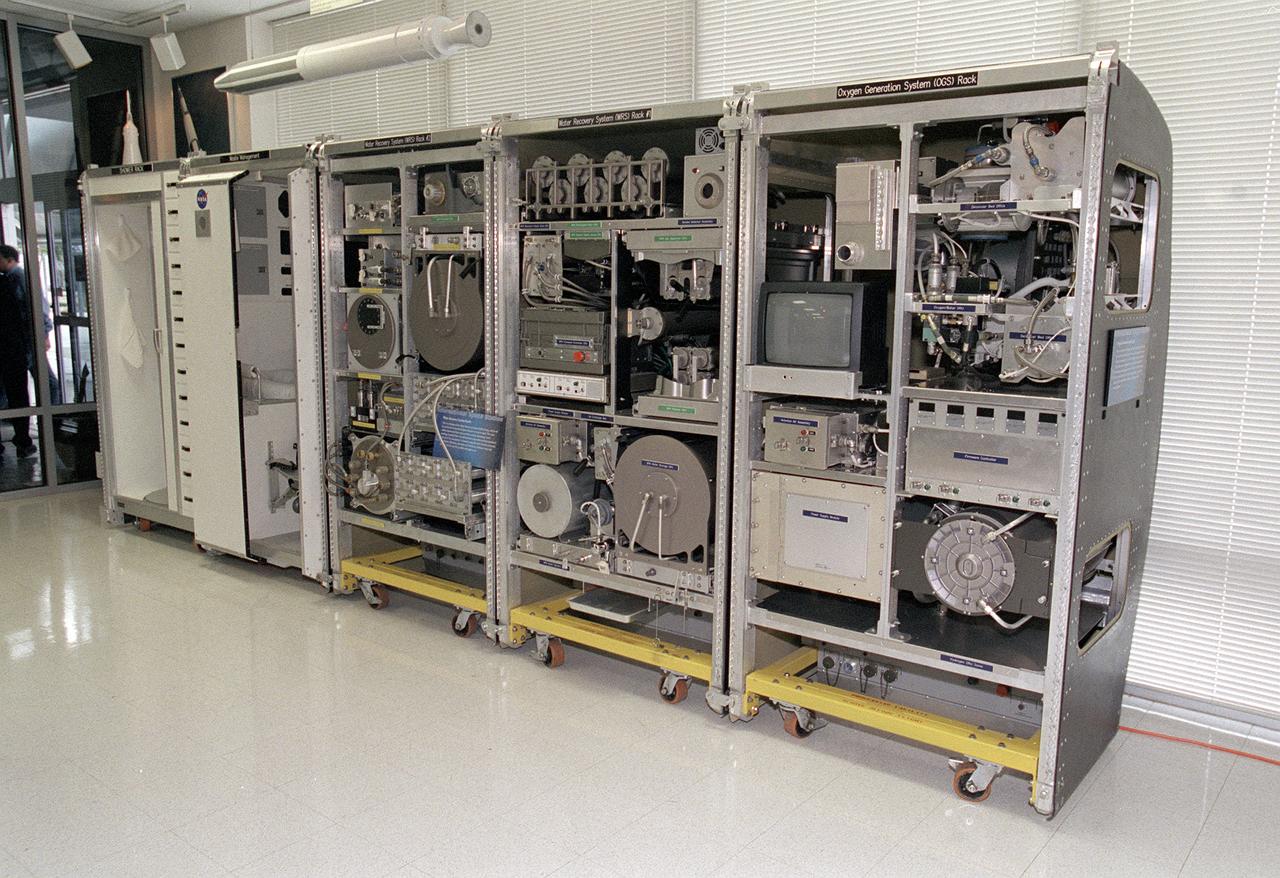
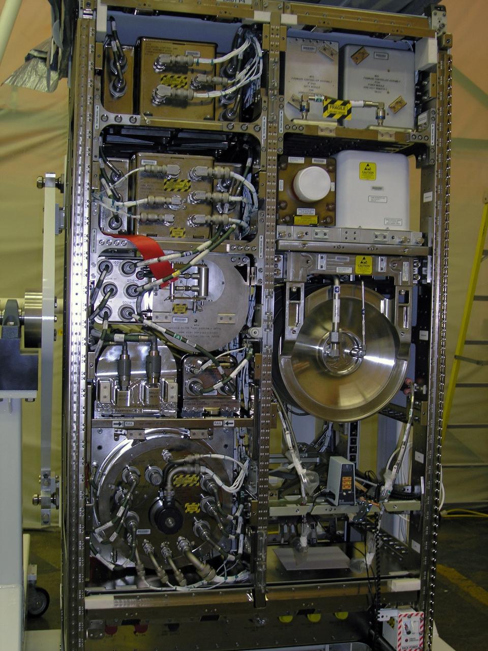
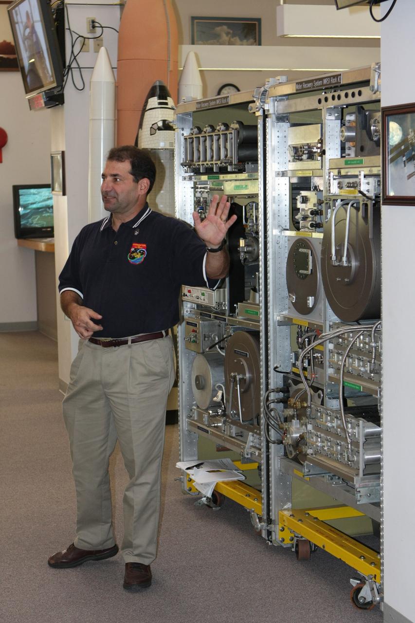
The Environmental Control and Life Support System (ECLSS) Group of the Flight Projects Directorate at the Marshall Space Flight Center in Huntsville, Alabama, is responsible for designing and building the life support systems that will provide the crew of the International Space Station (ISS) a comfortable environment in which to live and work. This photograph shows the mockup of the the ECLSS to be installed in the Node 3 module of the ISS. From left to right, shower rack, waste management rack, Water Recovery System (WRS) Rack #2, WRS Rack #1, and Oxygen Generation System (OGS) rack are shown. The WRS provides clean water through the reclamation of wastewaters and is comprised of a Urine Processor Assembly (UPA) and a Water Processor Assembly (WPA). The UPA accepts and processes pretreated crewmember urine to allow it to be processed along with other wastewaters in the WPA. The WPA removes free gas, organic, and nonorganic constituents before the water goes through a series of multifiltration beds for further purification. The OGS produces oxygen for breathing air for the crew and laboratory animals, as well as for replacing oxygen loss. The OGS is comprised of a cell stack, which electrolyzes (breaks apart the hydrogen and oxygen molecules) some of the clean water provided by the WRS, and the separators that remove the gases from the water after electrolysis.
This photograph is an interior view of the Orbital Workshop (OWS) upper level looking from the airlock hatch, showing the octagonal opening that separated the workshop's two levels. The trash airlock can be seen at center. The lower level of the OWS provided crew accommodations for sleeping, food preparation and consumption, hygiene, waste processing and disposal, and performance of certain experiments. The upper level consisted of a large work area and housed water storage tanks, a food freezer, storage vaults for film, scientific airlocks, mobility and stability experiment equipment, and other experimental equipment.

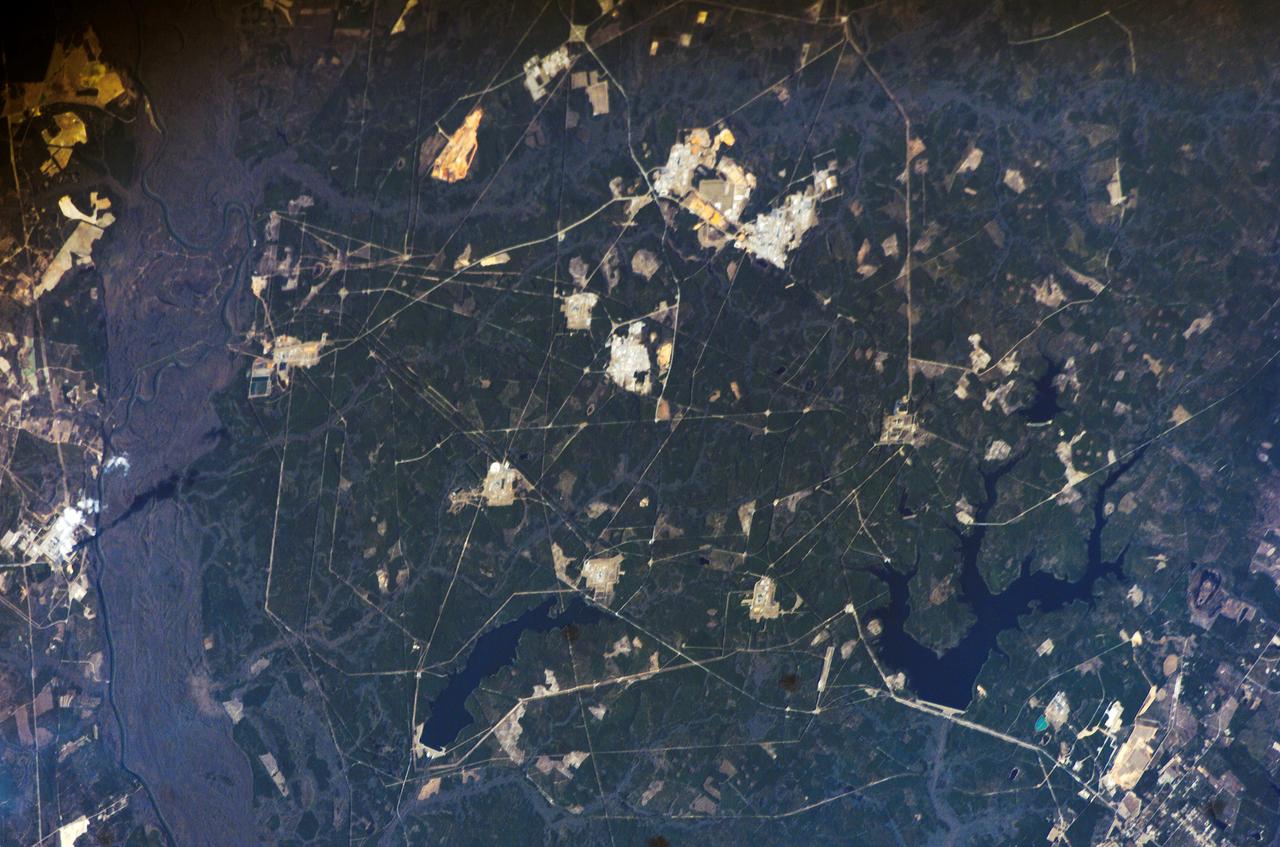
ISS019-E-005501 (9 April 2009) --- Split Region in Croatia is featured in this image photographed by an Expedition 19 crewmember on the International Space Station. One the world?s most rugged coastlines are located in Croatia along the Adriatic Sea. This view features the Dalmatian coastline of Croatia around the city of Split. Much of the region can be characterized by northwest-southeast oriented linear islands and embayments of the Adriatic Sea. This distinctive coastal geomorphology is the result of faulting caused by tectonic activity in the region and sea level rise. Split has a long history - the Roman Emperor Diocletian retired to Spalatum (the present-day Split) in 305, and his palace constitutes the core of the city today. The city is a popular resort destination for its historic sites, Mediterranean climate, and ready access to the Adriatic islands (such as Brac to the south). Other large cities in the region include Kastela and Trogir; together with Split, these form an almost continuous urban area bordering the coast (visible as pink regions). A thin zone marking a water boundary is visible in this image between Split and the island of Brac. It may represent a local plankton bloom, or a line of convergence between water masses creating rougher water. A unique combination of geography -- including dramatic topography that channels local winds, the complicated coastline, input of fresh water from rivers, and ample nutrients and surface oils -- makes for interesting mesoscale surface dynamics throughout the Adriatic Sea. Over the years, astronauts have taken images of the Split region using sunglint and changes in water color to highlight features like eddies, water boundaries and mixing zones between fresh waters flowing into the saltier (denser) waters of the Adriatic, and wind-driven surface currents. Split is an important transit center connecting islands in the Adriatic Sea to the Italian peninsula, and an important regional manufacturing center of goods such as solar cells, plastics, and paper products. The city was heavily industrialized during the post World War II period as a member state of Yugoslavia. By the 1980s, the marine environment bordered by Split, Kastela, and Trogir (known as Kastela Bay) had been identified as one of the most polluted areas of the Adriatic from both sewage and industrial wastes. Concerted efforts by the Croatian government and international partners to improve waste handling and treatment infrastructure over the past 10 years seem to have been successful ? both marine species and water polo players have returned to the area.
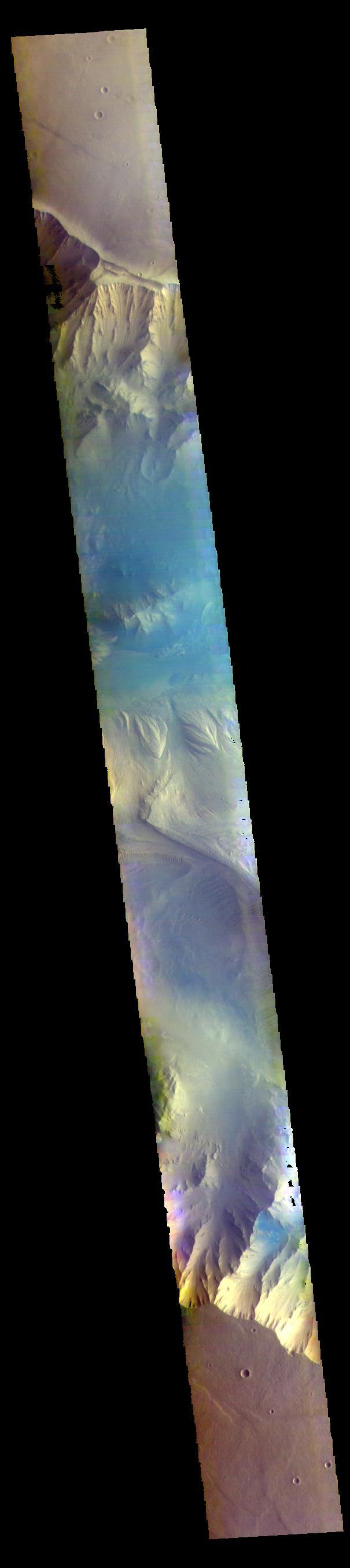
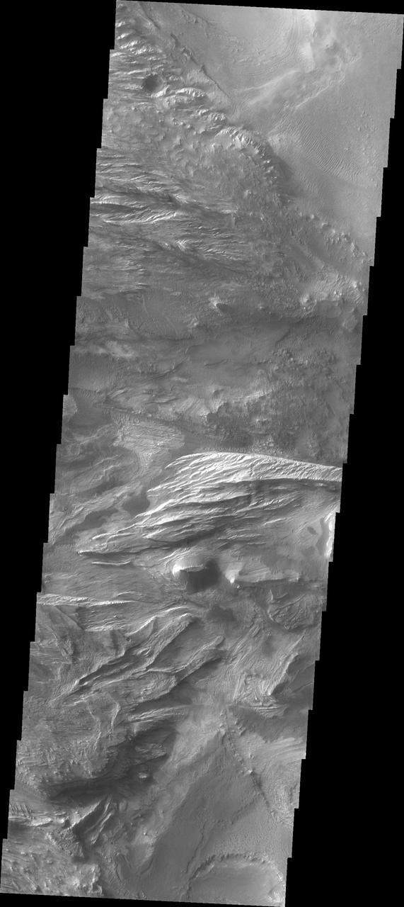
Today's VIS image shows part of Candor Chasma. Candor Chasma is one of the largest canyons that make up Valles Marineris. It is approximately 810 km long (503 miles) and has is divided into two regions – eastern and western Candor Chasma. Candor Chasma is located south of Ophir Chasma and north of Melas Chasma. The border with Melas Chasma contains many large landslide deposits. The floor of Candor Chasma includes a variety of landforms, including layered deposits, dunes, landslide deposits and steep sided cliffs and mesas. Many forms of erosion have shaped Candor Chasma. There is evidence of wind and water erosion, as well as significant gravity driven mass wasting (landslides). The bright features in this image are layered deposits that have been eroded by wind, and possible water. Orbit Number: 89623 Latitude: -6.93421 Longitude: 291.118 Instrument: VIS Captured: 2022-02-26 20:41 https://photojournal.jpl.nasa.gov/catalog/PIA25451
CAPE CANAVERAL, Fla. – In In the News Center at NASA's Kennedy Space Center in Florida, Bob Bagdigian (right) talks to the media about the Water Recovery System being delivered to the International Space Station on space shuttle Endeavour's STS-126 mission. Bagdigian is a project manager with NASA's Regenerative Environmental Control and Life Support System at Marshall Space Flight Center in Huntsville, Ala. Behind Bagdigian is a mockup of the two racks that will be used. The two units of the Water Recovery System are designed to provide drinking-quality water through the reclamation of wastewater, including urine and hygiene wastes. The water that’s produced will be used to support the crew and work aboard the station. STS-126 is the 124th space shuttle flight and the 27th flight to the International Space Station. The mission will feature four spacewalks and work that will prepare the space station to house six crew members for long- duration missions. Liftoff is scheduled for 7:55 p.m. EST Nov. 14. Photo credit: NASA/Dimitri Gerondidakis
CAPE CANAVERAL, Fla. – In the News Center at NASA's Kennedy Space Center in Florida, Bob Bagdigian talks to the media about the Water Recovery System being delivered to the International Space Station on space shuttle Endeavour's STS-126 mission. Bagdigian is a project manager with NASA's Regenerative Environmental Control and Life Support System at Marshall Space Flight Center in Huntsville, Ala. Behind Bagdigian is a mockup of the two racks that will be used. The two units of the Water Recovery System are designed to provide drinking-quality water through the reclamation of wastewater, including urine and hygiene wastes. The water that’s produced will be used to support the crew and work aboard the station. STS-126 is the 124th space shuttle flight and the 27th flight to the International Space Station. The mission will feature four spacewalks and work that will prepare the space station to house six crew members for long- duration missions. Liftoff is scheduled for 7:55 p.m. EST Nov. 14. Photo credit: NASA/Dimitri Gerondidakis

CAPE CANAVERAL, Fla. – In the News Center at NASA's Kennedy Space Center in Florida, Bob Bagdigian talks to the media about the Water Recovery System being delivered to the International Space Station on space shuttle Endeavour's STS-126 mission. Bagdigian is a project manager with NASA's Regenerative Environmental Control and Life Support System at Marshall Space Flight Center in Huntsville, Ala. Behind Bagdigian is a mockup of the two racks that will be used. The two units of the Water Recovery System are designed to provide drinking-quality water through the reclamation of wastewater, including urine and hygiene wastes. The water that’s produced will be used to support the crew and work aboard the station. STS-126 is the 124th space shuttle flight and the 27th flight to the International Space Station. The mission will feature four spacewalks and work that will prepare the space station to house six crew members for long- duration missions. Liftoff is scheduled for 7:55 p.m. EST Nov. 14. Photo credit: NASA/Dimitri Gerondidakis
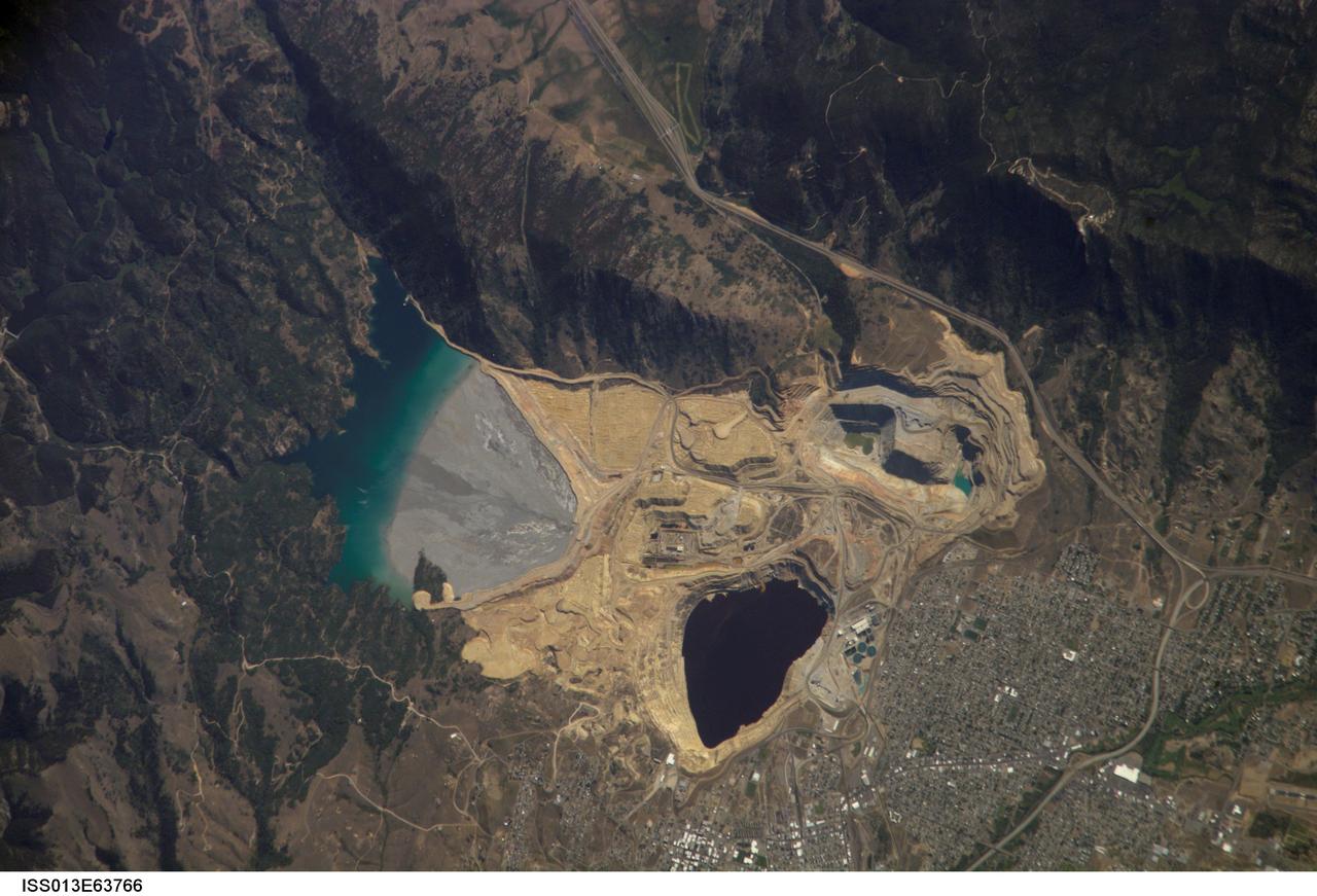
ISS013-E-63766 (2 Aug. 2006) --- Berkeley Pit and Butte, Montana are featured in this image photographed by an Expedition 13 crewmember on the International Space Station. The city of Butte, Montana has long been a center of mining activity. Underground mining of copper began in Butte in the 1870s, and by 1901 underground workings had extended to the groundwater table. Thus began the creation of an intricate complex of underground drains and pumps to lower the groundwater level and continue the extraction of copper. Water extracted from the mines was so rich in dissolved copper sulfate that it was also "mined" (by chemical precipitation) for the copper it contained. In 1955, the Anaconda Copper Mining Company began open-pit mining for copper in what is now know as the Berkeley Pit (dark oblong area in center). The mine took advantage of the existing subterranean drainage and pump network to lower groundwater until 1982, when the new owner ARCO suspended operations at the mine. The groundwater level swiftly rose, and today water in the Pit is more than 900 feet deep. Many features of the mine workings are visible in this image such as the many terraced levels and access roadways of the open mine pits (gray and tan sculptured surfaces). A large gray tailings pile of waste rock and an adjacent tailings pond are visible to the north of the Berkeley Pit. Color changes in the tailings pond are due primarily to changing water depth. The Berkeley Pit is listed as a federal Superfund site due to its highly acidic water, which contains high concentrations of metals such as copper and zinc. The Berkeley Pit receives groundwater flowing through the surrounding bedrock and acts as a "terminal pit" or sink for these heavy metal-laden waters. Ongoing efforts include regulation of water flow into the pit to reduce filling of the Pit and potential release of contaminated water into local aquifers or surface streams.
Today's VIS image shows part of eastern Candor Chasma. Candor Chasma is one of the largest canyons that make up Valles Marineris. It is approximately 810 km long (503 miles) and is divided into two regions – eastern and western Candor. Candor is located south of Ophir Chasma and north of Melas Chasma. The border with Melas Chasma contains many large landslide deposits. The floor of Candor Chasma includes a variety of landforms, including layered deposits (bright region in the center of the image), dunes, landslide deposits and steep sided cliffs and mesas. Many forms of erosion have shaped Candor Chasma. There is evidence of wind and water erosion, as well as significant gravity driven mass wasting (landslides). Orbit Number: 85817 Latitude: -6.96093 Longitude: 291.605 Instrument: VIS Captured: 2021-04-19 11:28 https://photojournal.jpl.nasa.gov/catalog/PIA24875
Today's VIS image shows western parts of Ophir Chasma (top of image) and Candor Chasma (bottom of image). Both are part of Valles Marineris. Candor Chasma is approximately 810 km long (503 miles) and is divided into two regions – eastern and western Candor. Ophir Chasma is approximately 317km long (197 miles). The floors of both chasmata include a variety of landforms, including layered deposits, dunes, landslide deposits and steep sided cliffs and mesas. Many forms of erosion have shaped both chasmata. There is evidence of wind and water erosion, as well as significant gravity driven mass wasting (landslides). Orbit Number: 93311 Latitude: -4.15087 Longitude: 286.533 Instrument: VIS Captured: 2022-12-27 11:51 https://photojournal.jpl.nasa.gov/catalog/PIA25850
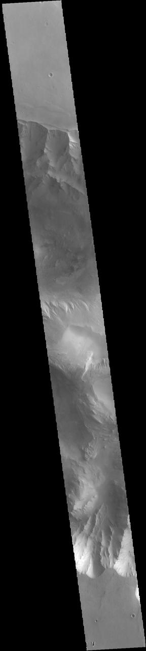
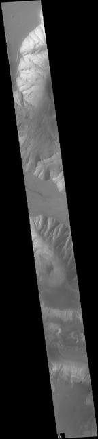
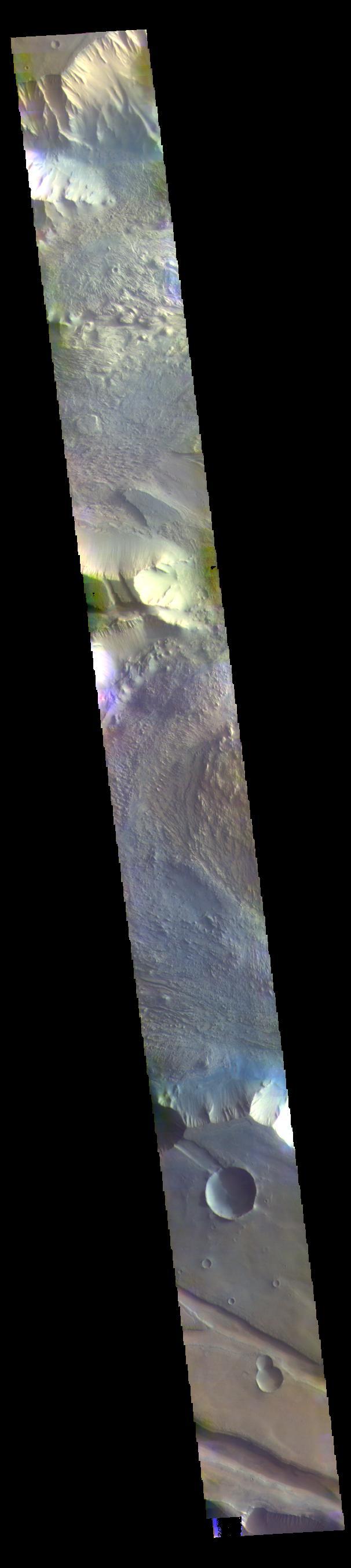
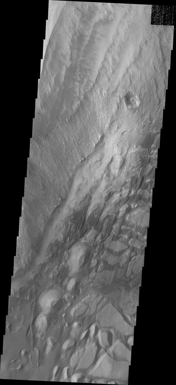
Candor Chasma is one of the largest canyons that make up Valles Marineris. It is approximately 810 km long (503 miles) and is divided into two regions – eastern and western Candor. Candor Chasma is located south of Ophir Chasma and north of Melas Chasma. The border with Melas Chasma contains many large landslide deposits. The floor of Candor Chasma includes a variety of landforms, including layered deposits, dunes, landslide deposits and steep sided cliffs and mesas. Many forms of erosion have shaped Candor Chasma. There is evidence of wind and water erosion, as well as significant gravity driven mass wasting (landslides). Orbit Number: 95151 Latitude: -7.05226 Longitude: 291.676 Instrument: VIS Captured: 2023-05-28 00:49 https://photojournal.jpl.nasa.gov/catalog/PIA26263
Today's VIS image shows part of eastern Candor Chasma. Candor Chasma is one of the largest canyons that make up Valles Marineris. It is approximately 810 km long (503 miles) and has is divided into two regions - eastern and western Candor. Candor is located south of Ophir Chasma and north of Melas Chasma. The border with Melas Chasma contains many large landslide deposits. The floor of Candor Chasma includes a variety of landforms, including layered deposits, dunes, landslide deposits and steep sided cliffs and mesas. Many forms of erosion have shaped Candor Chasma. There is evidence of wind and water erosion, as well as significant gravity driven mass wasting (landslides). Orbit Number: 88163 Latitude: -7.04697 Longitude: 292.058 Instrument: VIS Captured: 2021-10-29 15:27 https://photojournal.jpl.nasa.gov/catalog/PIA25152
Today's VIS image shows parts of Ophir Chasma (top of image) and Candor Chasma (bottom of image). Both are part of Valles Marineris. Candor Chasma is approximately 810 km long (503 miles) and is divided into two regions — eastern and western Candor. This image is of western Candor Chasma. The floor of Candor Chasma includes a variety of landforms, including layered deposits, dunes, landslide deposits and steep sided cliffs and mesas. Many forms of erosion have shaped Candor Chasma. There is evidence of wind and water erosion, as well as significant gravity driven mass wasting (landslides). Ophir Chasma is approximately 317km long (197 miles). This image shows the western end of Ophir Chasma. A landslide is visible in Ophir Chasma. Orbit Number: 82086 Latitude: -4.67658 Longitude: 285.773 Instrument: VIS Captured: 2020-06-16 06:38 https://photojournal.jpl.nasa.gov/catalog/PIA24123
Candor Chasma is one of the largest canyons that make up Valles Marineris. It is approximately 810 km long (503 miles) and is divided into two regions - eastern and western Candor. Candor is located south of Ophir Chasma and north of Melas Chasma. The border with Melas Chasma contains many large landslide deposits. The floor of Candor Chasma includes a variety of landforms, including layered deposits, dunes, landslide deposits and steep sided cliffs and mesas. Many forms of erosion have shaped Candor Chasma. There is evidence of wind and water erosion, as well as significant gravity driven mass wasting (landslides). Orbit Number: 94789 Latitude: -8.22898 Longitude: 295.219 Instrument: VIS Captured: 2023-04-28 05:27 https://photojournal.jpl.nasa.gov/catalog/PIA26158
ISS012-E-16633 (28 Jan. 2006) --- Savannah River Site, South Carolina is featured in this image photographed by an Expedition 12 crew member on the International Space Station. Situated between the South Carolina piedmont and the Atlantic Ocean, the Savannah River Site is an important part of the US Department of Energy’s nuclear program. Construction of the site – originally called the Savannah River Plant – began in 1951 for the purpose of generating radioactive materials, primarily the hydrogen isotope tritium and plutonium-239, necessary for nuclear weapons production during the Cold War. A total of five nuclear reactors occupy the central portion of the site and operated throughout 1953-1992. Following the end of the Cold War in 1991 activities at the Savannah River Site are now focused on disposal of nuclear wastes, environmental cleanup of the site itself, and development of advanced remediation technologies. The Savannah River Site is located in the Sand Hills region of South Carolina and includes an area of 800 square kilometers (300 square miles). The southern half of the Site (building clusters with reflective white rooftops) is shown. The nearby Savannah River and its tributary creeks provided a ready source of water for the nuclear reactors; to this end, two artificial lakes (“L” Lake and Par Pond) were constructed. The meandering channel of the River and its floodplain, characterized by grey-brown sediments, extends from northwest to southeast across the left portion of the image. The proximity of the River, and the permeable nature of the geological materials under laying the site (sand, clay, gravel, and carbonate rocks), necessitate extensive and ongoing environmental monitoring and cleanup efforts to reduce potential contamination of local water sources. According to NASA scientists, final remediation of wastes posing threats to surface and groundwater is scheduled to occur by 2025.

KENNEDY SPACE CENTER, FLA. -- Coots draw together (foreground) in the waters of the Merritt Island National Wildlife Refuge, which shares a boundary with Kennedy Space Center. They are often seen in the Indian River and Banana Creek swimming together in large groups such as these. Other birds, mainly ducks, swim nearby. Coots are readily identified by their slate-gray bodies and conspicuous white bill. They inhabit open ponds and marshes from southern Canada to northern South America. Excellent swimmers and divers, they eat various aquatic plants, but also feed on seeds grass and waste grain on land. The 92,000-acre refuge is a habitat for more than 330 species of birds, 31 mammals, 117 fishes and 65 amphibians and reptiles. The marshes and open water of the refuge provide wintering areas for 23 species of migratory waterfowl, as well as a year-round home for great blue herons, great egrets, wood storks, cormorants, brown pelicans and other species of marsh and shore birds
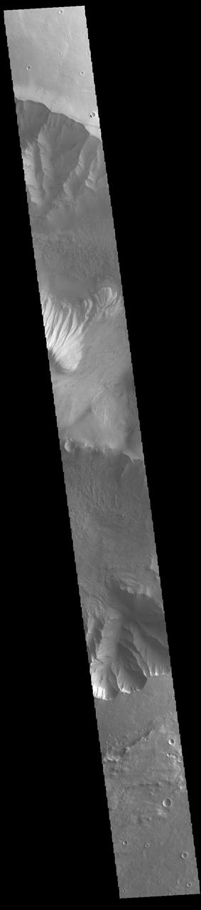
Today's VIS image shows a cross section of eastern Candor Chasma. In the center of this image is a large hill. The sides of the hill are deeply incised by erosion, probably including both wind and water processes. Candor Chasma is one of the largest canyons that make up Valles Marineris. It is approximately 810 km long (503 miles) and has is divided into two regions – eastern and western Candor. Candor is located south of Ophir Chasma and north of Melas Chasma. The border with Melas Chasma contains many large landslide deposits. The floor of Candor Chasma includes a variety of landforms, including layered deposits, dunes, landslide deposits and steep sided cliffs and mesas. Many forms of erosion have shaped Candor Chasma. There is evidence of wind and water erosion, as well as significant gravity driven mass wasting (landslides). Orbit Number: 89548 Latitude: -7.8126 Longitude: 294.967 Instrument: VIS Captured: 2022-02-20 16:28 https://photojournal.jpl.nasa.gov/catalog/PIA25379
KENNEDY SPACE CENTER, FLA. -- Coots draw together (foreground) in the waters of the Merritt Island National Wildlife Refuge, which shares a boundary with Kennedy Space Center. They are often seen in the Indian River and Banana Creek swimming together in large groups such as these. Other birds, mainly ducks, swim nearby. Coots are readily identified by their slate-gray bodies and conspicuous white bill. They inhabit open ponds and marshes from southern Canada to northern South America. Excellent swimmers and divers, they eat various aquatic plants, but also feed on seeds grass and waste grain on land. The 92,000-acre refuge is a habitat for more than 330 species of birds, 31 mammals, 117 fishes and 65 amphibians and reptiles. The marshes and open water of the refuge provide wintering areas for 23 species of migratory waterfowl, as well as a year-round home for great blue herons, great egrets, wood storks, cormorants, brown pelicans and other species of marsh and shore birds
Today's VIS image shows part of the large hill near the eastern edge of Candor Chasma. Layering is visible toward the bottom of the image. The sides of the hill are deeply incised by erosion, probably including both wind and water processes. Candor Chasma is one of the largest canyons that make up Valles Marineris. It is approximately 810 km long (503 miles) and has is divided into two regions - eastern and western Candor. Candor is located south of Ophir Chasma and north of Melas Chasma. The border with Melas Chasma contains many large landslide deposits. The floor of Candor Chasma includes a variety of landforms, including layered deposits, dunes, landslide deposits and steep sided cliffs and mesas. Many forms of erosion have shaped Candor Chasma. There is evidence of wind and water erosion, as well as significant gravity driven mass wasting (landslides). Orbit Number: 88687 Latitude: -7.91852 Longitude: 294.829 Instrument: VIS Captured: 2021-12-11 18:58 https://photojournal.jpl.nasa.gov/catalog/PIA25202
Ravines or very large gullies are actively forming on Mars during the coldest times of year, when carbon dioxide frost aids mass wasting as seen by NASA Mars Reconnaissance Orbiter. However, some of these ravines also show activity in the warmest time of year, in the form of recurring slope lineae (RSL); dark, narrow flows in some alcoves that flow part way down the channels. Few topographic changes have been seen in association with RSL, and they appear to be seeps of water that seasonally extend down slopes, then fade when inactive, and recur each warm season. Could the RSL activity carve the ravines? In some places the RSL extend to the ends of the fans and appear to match in scale, and perhaps gradually form the ravines. In other places, such as this image, the ravines are much larger than the RSL, so presently-observed RSL flow did not produce the larger landforms, but maybe the flow was greater in the past or maybe the RSL just follow the topography created by other processes. The largest ravines are on pole-facing slopes in the middle latitudes, where RSL have never been seen to form, unless the ravine creates a small equator-facing slope. http://photojournal.jpl.nasa.gov/catalog/PIA19458
The THEMIS VIS camera contains 5 filters. The data from different filters can be combined in multiple ways to create a false color image. These false color images may reveal subtle variations of the surface not easily identified in a single band image. Today's false color image shows part of Candor Chasma. Candor Chasma is one of the largest canyons that make up Valles Marineris. It is approximately 810 km long (503 miles) and has is divided into two regions – eastern and western Candor. Candor is located south of Ophir Chasma and north of Melas Chasma. The border with Melas Chasma contains many large landslide deposits. The floor of Candor Chasma includes a variety of landforms, including layered deposits (seen in this image), dunes, landslide deposits and steep sided cliffs and mesas. Many forms of erosion have shaped Candor Chasma. There is evidence of wind and water erosion, as well as significant gravity driven mass wasting (landslides). Orbit Number: 71132 Latitude: -6.71232 Longitude: 284.46 Instrument: VIS Captured: 2017-12-27 03:31 https://photojournal.jpl.nasa.gov/catalog/PIA24508
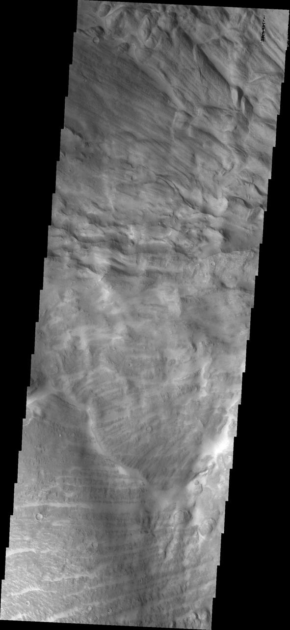
Today's VIS image shows part of the southern margin of Candor Chasma. While not as deep as the northern regions of eastern Candor Chasma, the southern region contains all the features seen at the lower elevations to the north. Candor Chasma is one of the largest canyons that make up Valles Marineris. It is approximately 810 km long (503 miles) and is divided into two regions - eastern and western Candor. Candor is located south of Ophir Chasma and north of Melas Chasma. The border with Melas Chasma contains many large landslide deposits. The floor of Candor Chasma includes a variety of landforms, including layered deposits, dunes, landslide deposits and steep sided cliffs and mesas. Many forms of erosion have shaped Candor Chasma. There is evidence of wind and water erosion, as well as significant gravity driven mass wasting (landslides). Orbit Number: 89860 Latitude: -8.00834 Longitude: 293.829 Instrument: VIS Captured: 2022-03-18 09:02 https://photojournal.jpl.nasa.gov/catalog/PIA25398
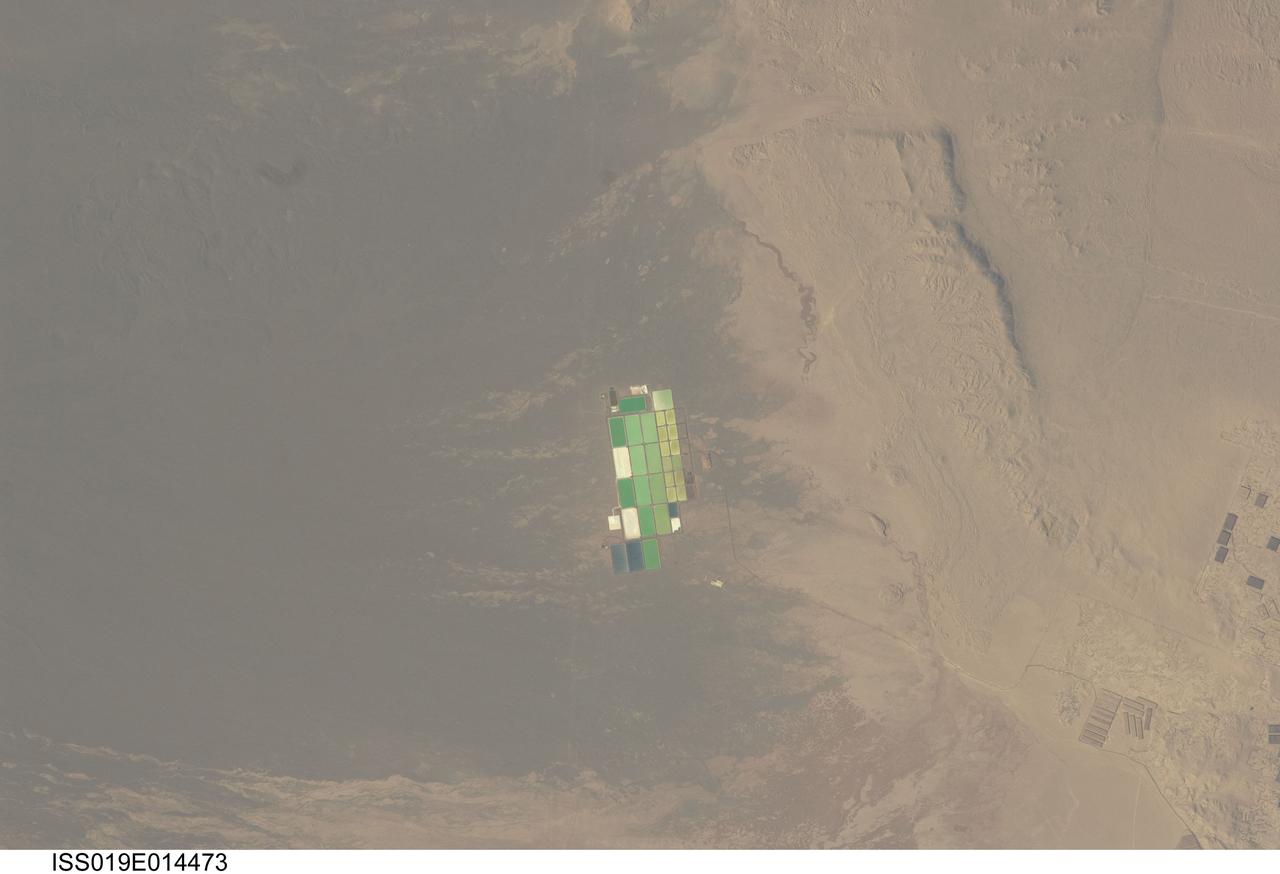
ISS019-E-014473 (5 May 2009) --- Salt ponds in Nueva Victoria, northern Chile are featured in this image photographed by an Expedition 19 crew member on the International Space Station. This view shows a long alluvial fan, sloping from east to west (left to right) in northern Chile with solar evaporation (or salt) ponds, some brightly colored, near the foot of the fan. The alluvial fan sediments are brown and contrast sharply with tan sediments of the Pampa del Tamarugal, the great hyper arid inner valley of Chile?s northern Atacama Desert. Nitrates and many other minerals are mined in this region. A few extraction pits and ore dumps are visible at bottom right, but most of the shallow diggings (0.5?5 meters deep) of a mine extracting caliche deposits ? a hard, cemented layer in the soil formed by downward movement and redeposition of sodium salts ? lie just outside the picture. Iodine is one of the products from mining; it is first extracted by a process known as heap leaching. Waste liquids from the iodine plants are dried in the tan and brightly colored evaporation ponds to crystallize nitrate salts for collection. Fertilizer production for higher-value crops is the main use for the recovered nitrates, but there are many other uses including the manufacture of pharmaceuticals, explosives, glass, ceramics, water treatment and metallurgical processes.
The THEMIS VIS camera contains 5 filters. The data from different filters can be combined in multiple ways to create a false color image. These false color images may reveal subtle variations of the surface not easily identified in a single band image. Today's false color image shows part of eastern Candor Chasma. Candor Chasma is one of the largest canyons that make up Valles Marineris. It is approximately 810 km long (503 miles) and has is divided into two regions — eastern and western Candor. Candor is located south of Ophir Chasma and north of Melas Chasma. The border with Melas Chasma contains many large landslide deposits. The floor of Candor Chasma includes a variety of landforms, including layered deposits, dunes, landslide deposits and steep sided cliffs and mesas. Many forms of erosion have shaped Candor Chasma. There is evidence of wind and water erosion, as well as significant gravity driven mass wasting (landslides). Orbit Number: 68438 Latitude: -7.05392 Longitude: 291.853 Instrument: VIS Captured: 2017-05-19 04:30 https://photojournal.jpl.nasa.gov/catalog/PIA24078
The THEMIS VIS camera contains 5 filters. The data from different filters can be combined in multiple ways to create a false color image. These false color images may reveal subtle variations of the surface not easily identified in a single band image. Today's false color image shows part of western Candor Chasma. Candor Chasma is one of the largest canyons that make up Valles Marineris. It is approximately 810 km long (503 miles) and has is divided into two regions — eastern and western Candor. Candor is located south of Ophir Chasma and north of Melas Chasma. The border with Melas Chasma contains many large landslide deposits. The floor of Candor Chasma includes a variety of landforms, including layered deposits, dunes, landslide deposits and steep sided cliffs and mesas. Many forms of erosion have shaped Candor Chasma. There is evidence of wind and water erosion, as well as significant gravity driven mass wasting (landslides). Orbit Number: 69411 Latitude: -5.95186 Longitude: 283.147 Instrument: VIS Captured: 2017-08-07 08:33 https://photojournal.jpl.nasa.gov/catalog/PIA24081

A prototype of Organic Processor Assembly (OPA) – technology capable of treating mixed organic wastes – arrives at the Neil Armstrong Operations and Checkout Building at NASA’s Kennedy Space Center in Florida on Aug. 19, 2020. At the heart of the OPA is an anaerobic membrane bioreactor – a hybrid technology that couples anaerobic digestion with membrane filtration. Developed through a collaboration between Kennedy’s Dr. Luke Roberson and the University of South Florida’s Dr. Daniel Yeh, the OPA was designed for an early planetary base scenario to help close the resource recovery loop, decreasing the agency’s dependence on resupply missions.

A prototype of Organic Processor Assembly (OPA) – technology capable of treating mixed organic wastes – arrives at the Neil Armstrong Operations and Checkout Building at NASA’s Kennedy Space Center in Florida on Aug. 19, 2020. Developed through a collaboration between Kennedy’s Dr. Luke Roberson and the University of South Florida’s Dr. Daniel Yeh, the OPA was designed for an early planetary base scenario to help close the resource recovery loop, decreasing the agency’s dependence on resupply missions. At the heart of the OPA is an anaerobic membrane bioreactor – a hybrid technology that couples anaerobic digestion with membrane filtration.

A prototype of Organic Processor Assembly (OPA) – technology capable of treating mixed organic wastes – arrives at the Neil Armstrong Operations and Checkout Building at NASA’s Kennedy Space Center in Florida on Aug. 19, 2020. At the heart of the OPA is an anaerobic membrane bioreactor – a hybrid technology that couples anaerobic digestion with membrane filtration. Developed through a collaboration between Kennedy’s Dr. Luke Roberson and the University of South Florida’s Dr. Daniel Yeh, the OPA was designed for an early planetary base scenario to help close the resource recovery loop, decreasing the agency’s dependence on resupply missions.

A prototype of Organic Processor Assembly (OPA) – technology capable of treating mixed organic wastes – arrives at the Neil Armstrong Operations and Checkout Building at NASA’s Kennedy Space Center in Florida on Aug. 19, 2020. At the heart of the OPA is an anaerobic membrane bioreactor – a hybrid technology that couples anaerobic digestion with membrane filtration. Developed through a collaboration between Kennedy’s Dr. Luke Roberson and the University of South Florida’s Dr. Daniel Yeh, the OPA was designed for an early planetary base scenario to help close the resource recovery loop, decreasing the agency’s dependence on resupply missions.
This image shows part of eastern Candor Chasma. At the bottom of the image is the steep cliff between the upper surface elevation and the depths of Candor Chasma. The small lobate feature at the base of the cliff in the bottom of the image is a landslide deposit formed by failure of the cliff face and gravitational downslope movement of the material. Candor Chasma is one of the largest canyons that make up Valles Marineris. It is approximately 810 km long (503 miles) and has is divided into two regions - eastern and western Candor. Candor is located south of Ophir Chasma and north of Melas Chasma. The border with Melas Chasma contains many large landslide deposits. The floor of Candor Chasma includes a variety of landforms, including layered deposits, dunes, landslide deposits and steep sided cliffs and mesas. Many forms of erosion have shaped Chandor Chasma. There is evidence of wind and water erosion, as well as significant gravity driven mass wasting (landslides). The Odyssey spacecraft has spent over 15 years in orbit around Mars, circling the planet more than 69000 times. It holds the record for longest working spacecraft at Mars. THEMIS, the IR/VIS camera system, has collected data for the entire mission and provides images covering all seasons and lighting conditions. Over the years many features of interest have received repeated imaging, building up a suite of images covering the entire feature. From the deepest chasma to the tallest volcano, individual dunes inside craters and dune fields that encircle the north pole, channels carved by water and lava, and a variety of other feature, THEMIS has imaged them all. For the next several months the image of the day will focus on the Tharsis volcanoes, the various chasmata of Valles Marineris, and the major dunes fields. We hope you enjoy these images! Orbit Number: 8916 Latitude: -7.95016 Longitude: 293.509 Instrument: VIS Captured: 2003-12-18 11:38 https://photojournal.jpl.nasa.gov/catalog/PIA22162
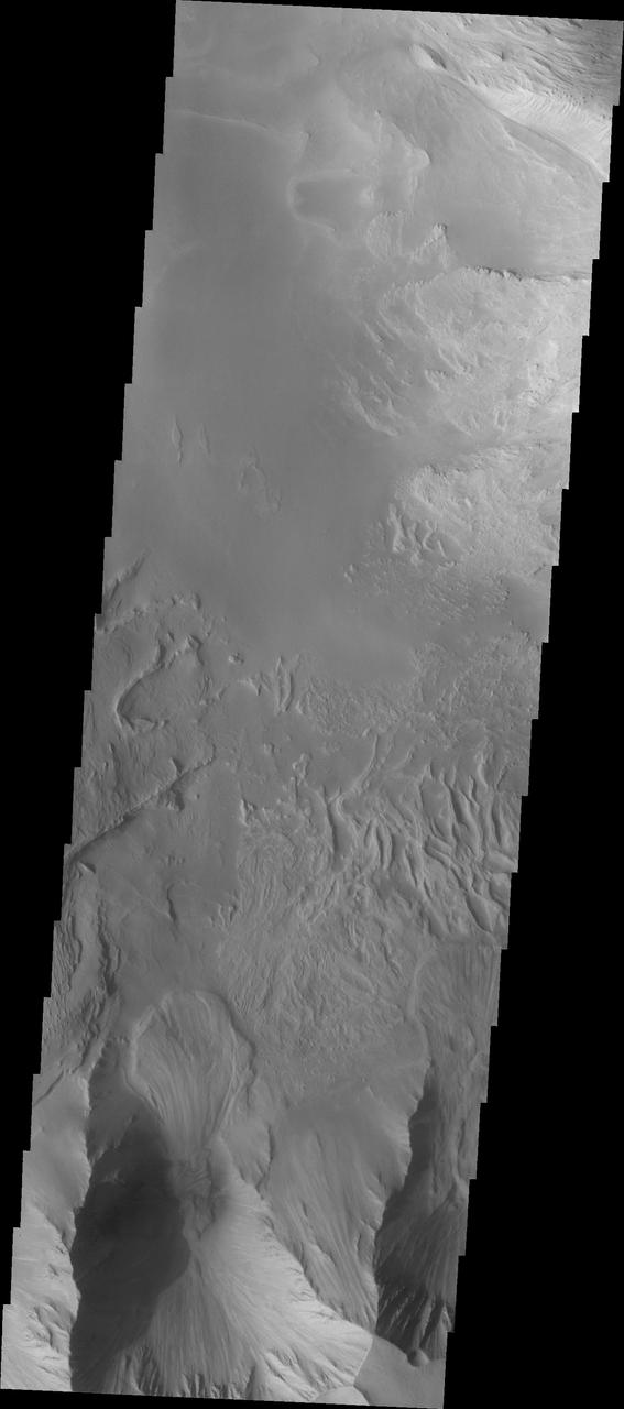
This image shows part of western Candor and the erosion of a large mesa. Layered materials are visible throughout the image. The dark material with the linear appearance in the middle of the image are sand dunes. Sand dunes are created by wind action. At the present time, wind is the active process shaping the surface. Candor Chasma is one of the largest canyons that make up Valles Marineris. It is approximately 810 km long (503 miles) and has is divided into two regions - eastern and western Candor. Candor is located south of Ophir Chasma and north of Melas Chasma. The border with Melas Chasma contains many large landslide deposits. The floor of Candor Chasma includes a variety of landforms, including layered deposits, dunes, landslide deposits and steep sided cliffs and mesas. Many forms of erosion have shaped Chandor Chasma. There is evidence of wind and water erosion, as well as significant gravity driven mass wasting (landslides). The Odyssey spacecraft has spent over 15 years in orbit around Mars, circling the planet more than 69000 times. It holds the record for longest working spacecraft at Mars. THEMIS, the IR/VIS camera system, has collected data for the entire mission and provides images covering all seasons and lighting conditions. Over the years many features of interest have received repeated imaging, building up a suite of images covering the entire feature. From the deepest chasma to the tallest volcano, individual dunes inside craters and dune fields that encircle the north pole, channels carved by water and lava, and a variety of other feature, THEMIS has imaged them all. For the next several months the image of the day will focus on the Tharsis volcanoes, the various chasmata of Valles Marineris, and the major dunes fields. We hope you enjoy these images! Orbit Number: 6245 Latitude: -5.77639 Longitude: 284.339 Instrument: VIS Captured: 2003-05-12 14:49 https://photojournal.jpl.nasa.gov/catalog/PIA22161
This image of central Candor Chasma shows a surface topography called chaos. Chaos is a region of small to medium sized mesas surrounded by valleys that are usually the same elevation. In this image sand and sand dunes have accumulated in the valleys near the top of the image, but are not as prevalent towards the bottom of the image. Candor Chasma is one of the largest canyons that make up Valles Marineris. It is approximately 810 km long (503 miles) and has is divided into two regions - eastern and western Candor. Candor is located south of Ophir Chasma and north of Melas Chasma. The border with Melas Chasma contains many large landslide deposits. The floor of Candor Chasma includes a variety of landforms, including layered deposits, dunes, landslide deposits and steep sided cliffs and mesas. Many forms of erosion have shaped Chandor Chasma. There is evidence of wind and water erosion, as well as significant gravity driven mass wasting (landslides). The Odyssey spacecraft has spent over 15 years in orbit around Mars, circling the planet more than 69000 times. It holds the record for longest working spacecraft at Mars. THEMIS, the IR/VIS camera system, has collected data for the entire mission and provides images covering all seasons and lighting conditions. Over the years many features of interest have received repeated imaging, building up a suite of images covering the entire feature. From the deepest chasma to the tallest volcano, individual dunes inside craters and dune fields that encircle the north pole, channels carved by water and lava, and a variety of other feature, THEMIS has imaged them all. For the next several months the image of the day will focus on the Tharsis volcanoes, the various chasmata of Valles Marineris, and the major dunes fields. We hope you enjoy these images! Orbit Number: 26213 Latitude: -7.25478 Longitude: 287.032 Instrument: VIS Captured: 2007-11-11 14:48 https://photojournal.jpl.nasa.gov/catalog/PIA22169
Candor Chasma is one of the largest canyons that make up Valles Marineris. It is approximately 810 km long (503 miles) and has is divided into two regions - eastern and western Candor. Candor is located south of Ophir Chasma and north of Melas Chasma. The border with Melas Chasma contains many large landslide deposits. The floor of Candor Chasma includes a variety of landforms, including layered deposits, dunes, landslide deposits and steep sided cliffs and mesas. Many forms of erosion have shaped Chandor Chasma. There is evidence of wind and water erosion, as well as significant gravity driven mass wasting (landslides). This image shows part of western Candor and the erosion of a large mesa. Layered materials are visible throughout the image and small dunes exist in several places. The Odyssey spacecraft has spent over 15 years in orbit around Mars, circling the planet more than 69000 times. It holds the record for longest working spacecraft at Mars. THEMIS, the IR/VIS camera system, has collected data for the entire mission and provides images covering all seasons and lighting conditions. Over the years many features of interest have received repeated imaging, building up a suite of images covering the entire feature. From the deepest chasma to the tallest volcano, individual dunes inside craters and dune fields that encircle the north pole, channels carved by water and lava, and a variety of other feature, THEMIS has imaged them all. For the next several months the image of the day will focus on the Tharsis volcanoes, the various chasmata of Valles Marineris, and the major dunes fields. We hope you enjoy these images! Orbit Number: 4360 Latitude: -6.08522 Longitude: 284.85 Instrument: VIS Captured: 2002-12-08 10:51 https://photojournal.jpl.nasa.gov/catalog/PIA22160
The bottom half of this image of central Candor Chasma shows a surface topography called chaos. Chaos is a region of small to medium sized mesas surrounded by valleys that are usually the same elevation. In this image sand and sand dunes are accumulating in the valleys and increasing in depth. Candor Chasma is one of the largest canyons that make up Valles Marineris. It is approximately 810 km long (503 miles) and has is divided into two regions - eastern and western Candor. Candor is located south of Ophir Chasma and north of Melas Chasma. The border with Melas Chasma contains many large landslide deposits. The floor of Candor Chasma includes a variety of landforms, including layered deposits, dunes, landslide deposits and steep sided cliffs and mesas. Many forms of erosion have shaped Chandor Chasma. There is evidence of wind and water erosion, as well as significant gravity driven mass wasting (landslides). The Odyssey spacecraft has spent over 15 years in orbit around Mars, circling the planet more than 69000 times. It holds the record for longest working spacecraft at Mars. THEMIS, the IR/VIS camera system, has collected data for the entire mission and provides images covering all seasons and lighting conditions. Over the years many features of interest have received repeated imaging, building up a suite of images covering the entire feature. From the deepest chasma to the tallest volcano, individual dunes inside craters and dune fields that encircle the north pole, channels carved by water and lava, and a variety of other feature, THEMIS has imaged them all. For the next several months the image of the day will focus on the Tharsis volcanoes, the various chasmata of Valles Marineris, and the major dunes fields. We hope you enjoy these images! Orbit Number: 18251 Latitude: -6.45589 Longitude: 287.35 Instrument: VIS Captured: 2006-01-25 01:39 https://photojournal.jpl.nasa.gov/catalog/PIA22168
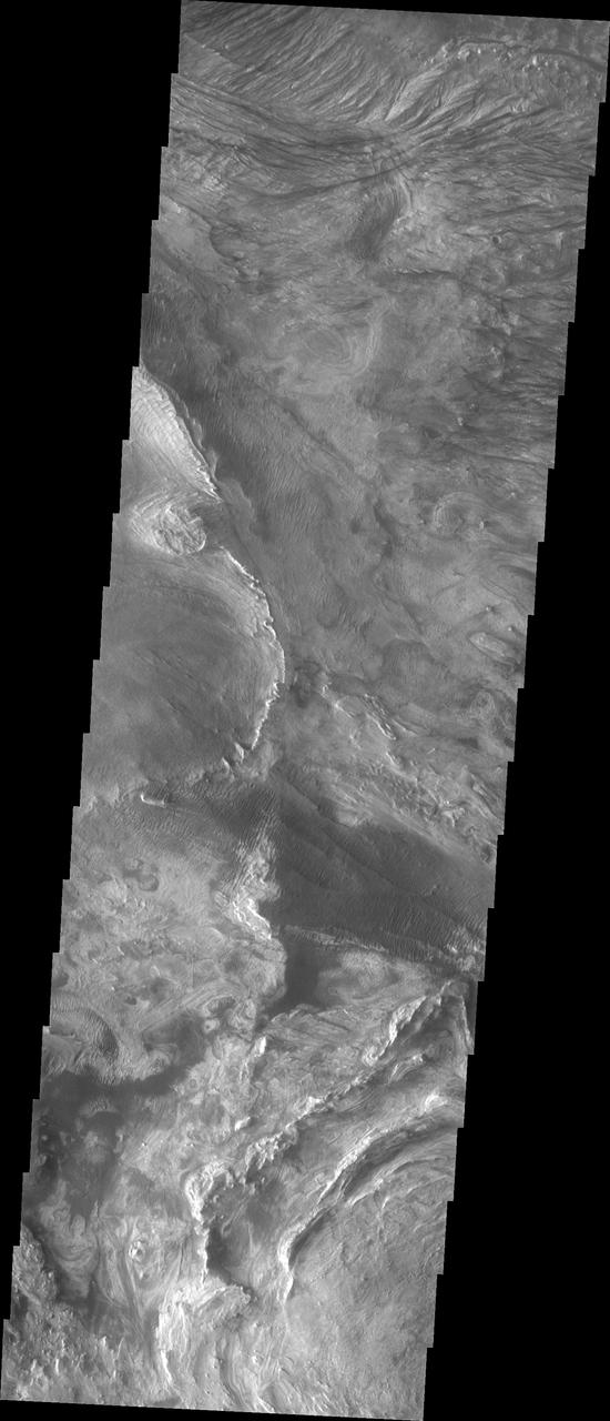
This VIS image shows part of the border between Chandor and Melas Chasmata. The entire image is landslide deposits. It is very common for landslides to develop linear surface grooves that parallel the direction of flow. Candor Chasma is one of the largest canyons that make up Valles Marineris. It is approximately 810 km long (503 miles) and has is divided into two regions - eastern and western Candor. Candor is located south of Ophir Chasma and north of Melas Chasma. The border with Melas Chasma contains many large landslide deposits. The floor of Candor Chasma includes a variety of landforms, including layered deposits, dunes, landslide deposits and steep sided cliffs and mesas. Many forms of erosion have shaped Chandor Chasma. There is evidence of wind and water erosion, as well as significant gravity driven mass wasting (landslides). The Odyssey spacecraft has spent over 15 years in orbit around Mars, circling the planet more than 69000 times. It holds the record for longest working spacecraft at Mars. THEMIS, the IR/VIS camera system, has collected data for the entire mission and provides images covering all seasons and lighting conditions. Over the years many features of interest have received repeated imaging, building up a suite of images covering the entire feature. From the deepest chasma to the tallest volcano, individual dunes inside craters and dune fields that encircle the north pole, channels carved by water and lava, and a variety of other feature, THEMIS has imaged them all. For the next several months the image of the day will focus on the Tharsis volcanoes, the various chasmata of Valles Marineris, and the major dunes fields. We hope you enjoy these images! Orbit Number: 17003 Latitude: -8.20616 Longitude: 288.108 Instrument: VIS Captured: 2005-10-14 07:36 https://photojournal.jpl.nasa.gov/catalog/PIA22167
This THEMIS image shows part of western Candor Chasma. Near the bottom of the image is an impact crater. Impact craters are relatively rare within all the canyons of Valles Marineris. The lack of craters may be due to the relative young age of the canyon system - younger surfaces on Mars have fewer craters than older surfaces. Another factor is that the high rate of erosion and deposition within the canyon erodes the ejecta blanket and fills in the crater, effectively removing the crater over time. Candor Chasma is one of the largest canyons that make up Valles Marineris. It is approximately 810 km long (503 miles) and has is divided into two regions - eastern and western Candor. Candor is located south of Ophir Chasma and north of Melas Chasma. The border with Melas Chasma contains many large landslide deposits. The floor of Candor Chasma includes a variety of landforms, including layered deposits, dunes, landslide deposits and steep sided cliffs and mesas. Many forms of erosion have shaped Chandor Chasma. There is evidence of wind and water erosion, as well as significant gravity driven mass wasting (landslides). The Odyssey spacecraft has spent over 15 years in orbit around Mars, circling the planet more than 69000 times. It holds the record for longest working spacecraft at Mars. THEMIS, the IR/VIS camera system, has collected data for the entire mission and provides images covering all seasons and lighting conditions. Over the years many features of interest have received repeated imaging, building up a suite of images covering the entire feature. From the deepest chasma to the tallest volcano, individual dunes inside craters and dune fields that encircle the north pole, channels carved by water and lava, and a variety of other feature, THEMIS has imaged them all. For the next several months the image of the day will focus on the Tharsis volcanoes, the various chasmata of Valles Marineris, and the major dunes fields. We hope you enjoy these images! Orbit Number: 16479 Latitude: -5.02282 Longitude: 284.268 Instrument: VIS Captured: 2005-09-01 04:09 https://photojournal.jpl.nasa.gov/catalog/PIA22166
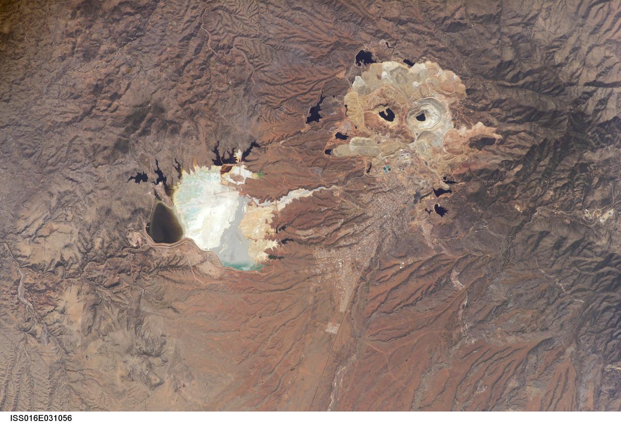
ISS016-E-031056 (3 March 2008) --- Cananea Copper Mine, Sonora, Mexico is featured in this image photographed by an Expedition 16 crewmember on the International Space Station. One of the largest open-pit copper mines in the world, the Cananea mine produced over 164,000 tons of copper in 2006. The mine is located approximately 40 kilometers south of the border between the USA (Arizona) and Mexico (Sonora). Copper and gold ores at Cananea are found in a porphyry copper deposit, a geological structure formed by crystal-rich magma moving upwards through pre-existing rock layers. A porphyry - an igneous rock with large crystals in a fine-grained matrix -- is formed as the magma cools and crystallizes. While crystallization is occurring, hot fluids can circulate through the magma and surrounding rocks via fractures. This hydrothermal alteration of the rocks typically forms copper-bearing and other minerals. Much of the Cananea mine's ore is concentrated in breccia pipes -- mineralized rod or chimney-shaped bodies that contain broken rock fragments. The active, two-kilometers-in-diameter Colorada Pit (top right) is recognizable in this image by the concentric steps or benches cut around its perimeter. These benches allow for access into the pit for extraction of ore and waste materials. Water (black) is visible filling the bottom of the pit, and several other basins in the surrounding area. The city of Cananea -- marked by its street grid -- is located to the northeast of the mine workings. A leachate reservoir is located to the east of the mine (lower left) for removal and evaporation of water pumped from the mine workings -- the bluish-white coloration of deposits near the reservoir suggests the high mineral content of the leachate. A worker strike halted mine operations in 2007.
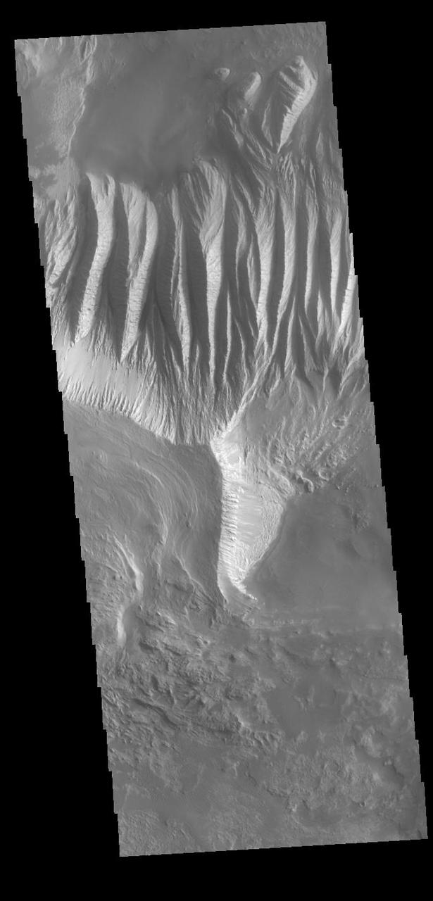
This image shows part of eastern Candor Chasma. At the top of the image is the steep cliff between the upper surface elevation and the depths of Candor Chasma. The bottom of the image is the cliff side of a large mesa. The two cliff faces have very different appearances. The cliff face between the top of the canyon and the bottom is likely layers of volcanic flows from the nearby Tharsis volcanoes. The mesa, however, is probably layers of sediments deposited in the canyon from wind, water and gravity driven erosion and deposition. These layered materials are much more easily eroded than the solid rock of the canyon sides. There is a landslide that originate from the northern cliff face and ran out into the canyon floor, visible as the lobate "tongue" at the right near the center of the image. Candor Chasma is one of the largest canyons that make up Valles Marineris. It is approximately 810 km long (503 miles) and has is divided into two regions - eastern and western Candor. Candor is located south of Ophir Chasma and north of Melas Chasma. The border with Melas Chasma contains many large landslide deposits. The floor of Candor Chasma includes a variety of landforms, including layered deposits, dunes, landslide deposits and steep sided cliffs and mesas. Many forms of erosion have shaped Chandor Chasma. There is evidence of wind and water erosion, as well as significant gravity driven mass wasting (landslides). The Odyssey spacecraft has spent over 15 years in orbit around Mars, circling the planet more than 69000 times. It holds the record for longest working spacecraft at Mars. THEMIS, the IR/VIS camera system, has collected data for the entire mission and provides images covering all seasons and lighting conditions. Over the years many features of interest have received repeated imaging, building up a suite of images covering the entire feature. From the deepest chasma to the tallest volcano, individual dunes inside craters and dune fields that encircle the north pole, channels carved by water and lava, and a variety of other feature, THEMIS has imaged them all. For the next several months the image of the day will focus on the Tharsis volcanoes, the various chasmata of Valles Marineris, and the major dunes fields. We hope you enjoy these images! Orbit Number: 36232 Latitude: -6.78692 Longitude: 292.732 Instrument: VIS Captured: 2010-02-13 14:46 https://photojournal.jpl.nasa.gov/catalog/PIA22170
This image shows part of eastern Candor Chasma. At the top of the image is the steep cliff between the upper surface elevation and the depths of Candor Chasma. The bottom of the image is the cliff side of a large mesa. The two cliff faces have very different appearances. The cliff face between the top of the canyon and the bottom is likely layers of volcanic flows from the nearby Tharsis volcanoes. The mesa, however, is probably layers of sediments deposited in the canyon from wind, water and gravity driven erosion and deposition. These layered materials are much more easily eroded than the solid rock of the canyon sides. Candor Chasma is one of the largest canyons that make up Valles Marineris. It is approximately 810 km long (503 miles) and has is divided into two regions - eastern and western Candor. Candor is located south of Ophir Chasma and north of Melas Chasma. The border with Melas Chasma contains many large landslide deposits. The floor of Candor Chasma includes a variety of landforms, including layered deposits, dunes, landslide deposits and steep sided cliffs and mesas. Many forms of erosion have shaped Chandor Chasma. There is evidence of wind and water erosion, as well as significant gravity driven mass wasting (landslides). The Odyssey spacecraft has spent over 15 years in orbit around Mars, circling the planet more than 69000 times. It holds the record for longest working spacecraft at Mars. THEMIS, the IR/VIS camera system, has collected data for the entire mission and provides images covering all seasons and lighting conditions. Over the years many features of interest have received repeated imaging, building up a suite of images covering the entire feature. From the deepest chasma to the tallest volcano, individual dunes inside craters and dune fields that encircle the north pole, channels carved by water and lava, and a variety of other feature, THEMIS has imaged them all. For the next several months the image of the day will focus on the Tharsis volcanoes, the various chasmata of Valles Marineris, and the major dunes fields. We hope you enjoy these images! Orbit Number: 9540 Latitude: -6.76471 Longitude: 292.539 Instrument: VIS Captured: 2004-02-07 20:41 https://photojournal.jpl.nasa.gov/catalog/PIA22163
This image shows part of eastern Candor Chasma. In the middle of the image is a set of linear ridges and valleys. These features are called yardangs and are created by uniform winds that winnow away materials. Once the valleys are formed the wind then is funneled through the valley and erosion continues more in the valley than on the ridges. At the bottom of the valleys there are sand materials covering the slope between the valleys and the surrounding chasma floor. Beyond this coating of sand there are darker sand deposits where wind has accumulated the sand into larger dunes. The brighter mesa on the right side of the image has also been wind eroded into yardangs, but are aligned in a different direction than the larger yardangs. This indicates that wind directions within the canyon have changed over time. Candor Chasma is one of the largest canyons that make up Valles Marineris. It is approximately 810 km long (503 miles) and has is divided into two regions - eastern and western Candor. Candor is located south of Ophir Chasma and north of Melas Chasma. The border with Melas Chasma contains many large landslide deposits. The floor of Candor Chasma includes a variety of landforms, including layered deposits, dunes, landslide deposits and steep sided cliffs and mesas. Many forms of erosion have shaped Chandor Chasma. There is evidence of wind and water erosion, as well as significant gravity driven mass wasting (landslides). The Odyssey spacecraft has spent over 15 years in orbit around Mars, circling the planet more than 69000 times. It holds the record for longest working spacecraft at Mars. THEMIS, the IR/VIS camera system, has collected data for the entire mission and provides images covering all seasons and lighting conditions. Over the years many features of interest have received repeated imaging, building up a suite of images covering the entire feature. From the deepest chasma to the tallest volcano, individual dunes inside craters and dune fields that encircle the north pole, channels carved by water and lava, and a variety of other feature, THEMIS has imaged them all. For the next several months the image of the day will focus on the Tharsis volcanoes, the various chasmata of Valles Marineris, and the major dunes fields. We hope you enjoy these images! Orbit Number: 10551 Latitude: -6.93639 Longitude: 288.562 Instrument: VIS Captured: 2004-05-01 02:24 https://photojournal.jpl.nasa.gov/catalog/PIA22165
A vigorous summer fire season continued through July, 2013 as many large wildfires continued to burn in the forests of northern Canada. The high fire activity not only laid waste to thousands of hectares of boreal forest, but sent thick smoke billowing high into the atmosphere, where it was carried far across the Atlantic Ocean. On July 30, the Moderate Resolution Imaging Spectroradiometer (MODIS) aboard NASA’s Aqua satellite captured this true-color image of a river of smoke spreading south across the Hudson Bay. The blue background is formed by the waters of Hudson Bay. In the southeast the green, forest-covered land of Quebec province peeks from under a large cloud bank. Another large bank of white cloud covers the water in the southwest, and a smaller cloud bank covers the territory of Nunavut in the northwest. A bit of Baffin Island can be seen near the top center of the image. Looking closely at the image, it appears that the gray smoke mixes with whiter cloud in the south, suggesting they may be at the same level in the atmosphere. In the northeast corner of the image, a ribbon of smoke appears to blow over a bank of popcorn clouds as well as over a few lower-lying clouds, causing some of the clouds to appear gray beneath the smoky veil. Where cloud meets smoke in the northeast, however, the line of the cloud bank remains sharp, while the smoke appears to continue traveling under the edge. Although these interpretations are somewhat subjective in this true-color image, the false-color image of the same scene (not shown here) lends strength to the interpretation. Data from other NASA instruments, designed to measure cloud height and characteristics, agree that clouds vary in height, and that smoke mingles with cloud in the south. Credit: NASA/GSFC/Jeff Schmaltz/MODIS Land Rapid Response Team <b><a href="http://www.nasa.gov/audience/formedia/features/MP_Photo_Guidelines.html" rel="nofollow">NASA image use policy.</a></b> <b><a href="http://www.nasa.gov/centers/goddard/home/index.html" rel="nofollow">NASA Goddard Space Flight Center</a></b> enables NASA’s mission through four scientific endeavors: Earth Science, Heliophysics, Solar System Exploration, and Astrophysics. Goddard plays a leading role in NASA’s accomplishments by contributing compelling scientific knowledge to advance the Agency’s mission. <b>Follow us on <a href="http://twitter.com/NASA_GoddardPix" rel="nofollow">Twitter</a></b> <b>Like us on <a href="http://www.facebook.com/pages/Greenbelt-MD/NASA-Goddard/395013845897?ref=tsd" rel="nofollow">Facebook</a></b> <b>Find us on <a href="http://instagram.com/nasagoddard?vm=grid" rel="nofollow">Instagram</a></b>
This image shows a portion of Lethe Vallis, an outflow channel that also transported lava. Another investigation of this area (Balme et al., 2011) discovered a repeat pattern of dune-like forms in the channel interpreted as fluvial dunes (or, giant current ripples) which are dunes formed by flowing water. This is one of only a few places on Mars where these pristine-appearing landforms have been identified. The channel formed by catastrophic floods, during which it produced the prominent crater-cored, teardroped-shaped island in the middle. The island has the blunter end pointing upstream and the long tail pointing downstream. Both the island and the fluvial dunes were formed by these extreme floods and their size is an indicator of the enormous discharges required to create them. The margins of the channel also show the terminal front of a pristine lava flow unit that inundated the channel from the south and the dunes show the remnants of another older lava flow. The top of the island displays polygonal patterned ground texture, which is a characteristic of periglacial processes in ice-rich ground. The dark materials from the channel and island walls are probably dark sand being eroded from an underlying horizontal basaltic (lava) layer. The crater at the core of the island has elongated dunes and reticulate dust ridges inside. This single image thus contains features formed by periglacial, volcanic, fluvial, impact, aeolian and mass wasting processes, all in one place. http://photojournal.jpl.nasa.gov/catalog/PIA21039