
This narrow-angle color image of the Earth, dubbed Pale Blue Dot, is a part of the first ever 'portrait' of the solar system taken by NASA’s Voyager 1. The spacecraft acquired a total of 60 frames for a mosaic of the solar system from a distance of more than 4 billion miles from Earth and about 32 degrees above the ecliptic. From Voyager's great distance Earth is a mere point of light, less than the size of a picture element even in the narrow-angle camera. Earth was a crescent only 0.12 pixel in size. Coincidentally, Earth lies right in the center of one of the scattered light rays resulting from taking the image so close to the sun. This blown-up image of the Earth was taken through three color filters -- violet, blue and green -- and recombined to produce the color image. The background features in the image are artifacts resulting from the magnification. http://photojournal.jpl.nasa.gov/catalog/PIA00452

In this rare image taken on 19 July, the wide-angle camera on the international Cassini spacecraft has captured Saturn’s rings and our planet Earth and Moon in the same frame. The dark side of Saturn, its bright limb, the main rings, the F ring, and the G and E rings are clearly seen; the limb of Saturn and the F ring are overexposed. The ‘breaks’ in the brightness of Saturn’s limb are due to the shadows of the rings on the globe of Saturn, preventing sunlight from shining through the atmosphere in those regions. The E and G rings have been brightened for better visibility. Earth, 1.44 billion km away in this image, appears as a blue dot at centre right; the Moon can be seen as a fainter protrusion off its right side. The other bright dots nearby are stars. <b><a href="http://www.nasa.gov/audience/formedia/features/MP_Photo_Guidelines.html" rel="nofollow">NASA image use policy.</a></b> <b><a href="http://www.nasa.gov/centers/goddard/home/index.html" rel="nofollow">NASA Goddard Space Flight Center</a></b> enables NASA’s mission through four scientific endeavors: Earth Science, Heliophysics, Solar System Exploration, and Astrophysics. Goddard plays a leading role in NASA’s accomplishments by contributing compelling scientific knowledge to advance the Agency’s mission. <b>Follow us on <a href="http://twitter.com/NASAGoddardPix" rel="nofollow">Twitter</a></b> <b>Like us on <a href="http://www.facebook.com/pages/Greenbelt-MD/NASA-Goddard/395013845897?ref=tsd" rel="nofollow">Facebook</a></b> <b>Find us on <a href="http://instagrid.me/nasagoddard/?vm=grid" rel="nofollow">Instagram</a></b>

For the 30th anniversary of one of the most iconic images taken by NASA's Voyager mission, a new version of the image known as "the Pale Blue Dot." Planet Earth is visible as a bright speck within the sunbeam just right of center and appears softly blue, as in the original version published in 1990 (see PIA00452). This updated version uses modern image-processing software and techniques to revisit the well-known Voyager view while attempting to respect the original data and intent of those who planned the images. In 1990, the Voyager project planned to shut off the Voyager 1 spacecraft's imaging cameras to conserve power and because the probe, along with its sibling Voyager 2, would not fly close enough to any other objects to take pictures. Before the shutdown, the mission commanded the probe to take a series of 60 images designed to produce what they termed the "Family Portrait of the Solar System." Executed on Valentine's Day 1990, this sequence returned images for making color views of six of the solar system's planets and also imaged the Sun in monochrome. The popular name of this view is traced to the title of the 1994 book by Voyager imaging scientist Carl Sagan, who originated the idea of using Voyager's cameras to image the distant Earth and played a critical role in enabling the family portrait images to be taken. The image of Earth was originally published by NASA in 1990. It is republished here to commemorate the 30th anniversary of the Family Portrait of the Solar System (see PIA00451) and the Pale Blue Dot image in particular. The planet occupies less than a single pixel in the image and thus is not fully resolved. (The actual width of the planet on the sky was less than one pixel in Voyager's camera.) By contrast, Jupiter and Saturn were large enough to fill a full pixel in their family portrait images. The direction of the Sun is toward the bottom of the view (where the image is brightest). Rays of sunlight scattered within the camera optics stretch across the scene. One of those light rays happens to have intersected dramatically with Earth. From Voyager 1's vantage point — a distance of approximately 3.8 billion miles (6 billion kilometers) — Earth was separated from the Sun by only a few degrees. The close proximity of the inner planets to the Sun was a key factor preventing these images from being taken earlier in the mission, as our star was still close and bright enough to damage the cameras with its blinding glare. The view is a color composite created by combining images taken using green, blue and violet spectral filters by the Voyager 1 Narrow-Angle Camera. They were taken at 4:48 GMT on Feb. 14, 1990, just 34 minutes before Voyager 1 powered off its cameras forever. Like the original version, this is technically a "false-color" view, as the color-filter images used were mapped to red, green and blue, respectively. The brightness of each color channel was balanced relative to the others, which is likely why the scene appears brighter but less grainy than the original. In addition, the color was balanced so that the main sunbeam (which overlays Earth) appears white, like the white light of the Sun. At its original resolution, the newly processed color image is 666 by 659 pixels in size; this is Figure A. The main image is an enlarged version. The image was processed by JPL engineer and image processing enthusiast Kevin M. Gill with input from two of the image's original planners, Candy Hansen and William Kosmann. https://photojournal.jpl.nasa.gov/catalog/PIA23645
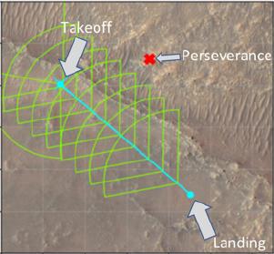
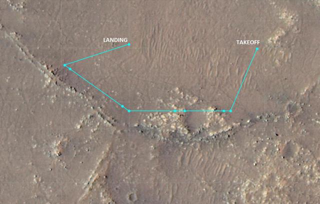
This annotated image of the "South Séítah" region of Jezero Crater depicts the planned ground track of NASA's Ingenuity Mars Helicopter (light blue) during its 15th flight at Mars. The pale blue "X" in the upper left indicates the helicopter's location at takeoff; the pale blue dot at lower right indicates the anticipated landing site. The green lines indicate the expected sightlines that will be captured in the flight's 10 planned color images. The red "X" at upper center of the image marks the current location of NASA's Perseverance rover. The image's background terrain was generated using data collected by the HiRISE camera aboard NASA's Mars Reconnaissance Orbiter. https://photojournal.jpl.nasa.gov/catalog/PIA24977
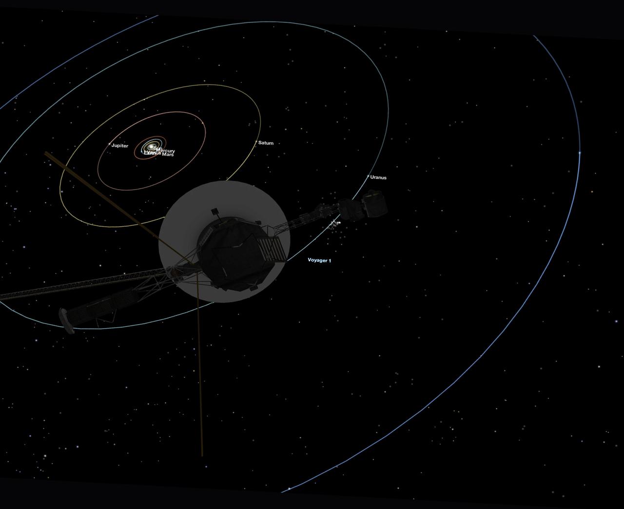
This simulated view, made using NASA's Eyes on the Solar System app, approximates Voyager 1's perspective when it took its final series of images known as the "Family Portrait of the Solar System," including the "Pale Blue Dot" image. https://photojournal.jpl.nasa.gov/catalog/PIA23681
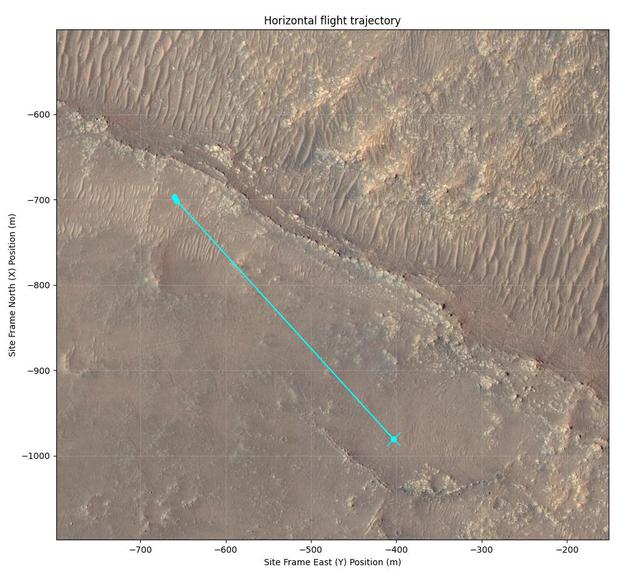
This annotated image of Mars' Jezero Crater depicts the ground track and waypoints of the Ingenuity Mars Helicopter's planned 11th flight, scheduled to take place no earlier than Aug. 4, 2021. It was generated using terrain imaged by the HiRISE camera aboard NASA's Mars Reconnaissance Orbiter. The goal of Flight 11 is to move Ingenuity to a new location where it can support the Perseverance rover by obtaining imagery of geologic features in the "South Seítah" area. This graphic indicates the helicopter's location at takeoff with a pale blue dot on the lower right; upper-left dots indicate its new landing site. https://photojournal.jpl.nasa.gov/catalog/PIA24690
jsc2025e034097 (Feb. 14, 2025) --- The Crew-11 mission patch embodies teamwork, exploration, and the deep connections that bind us—across nations, agencies, and families. Shades of white, red, and blue pay tribute to the flags of the three nations represented by the crew, while three gold stars symbolize the unity of our three space agencies working together in pursuit of discovery. .At the heart of the design, two radiant sunbeams form the number “11” illuminating a blue circle—a subtle nod to Voyager’s Pale Blue Dot image, reminding us of the fragile unity of our shared home. This vision of Earth is reflected in the dragon’s eye, reinforcing our focus on exploration and the perspective gained from space. .The dragon, evoking the heraldry of family crests, stands as a guardian of our mission and legacy. Within the stars, we honor the children of the crew, a reminder of the generations inspired by human spaceflight. Encircling it all, a red flame represents both the power of launch and the plasma of reentry, symbolizing the full journey—our departure from Earth, our work aboard the International Space Station, and our safe return home. Crew-11: Together, we rise.
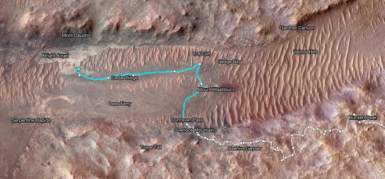
Superimposed on an image taken by the HiRISE camera aboard NASA's Mars Reconnaissance Orbiter, this map shows the path taken by the agency's Perseverance Mars rover between Jan. 31, 2024, and June 11, shortly after it arrived at a geologic area of interest the science team calls "Bright Angel." The route where the rover paralleled the Neretva Vallis river channel is depicted in white. The portion of the route where the rover was inside the river channel is depicted in pale blue. The dots along the white line signify locations where the rover stopped after completing a traverse. The University of Arizona, in Tucson, operates HiRISE, which was built by BAE Systems, in Boulder, Colorado. JPL manages the Mars Reconnaissance Orbiter Project for NASA's Science Mission Directorate, Washington. A key objective for Perseverance's mission on Mars is astrobiology, including the search for signs of ancient microbial life. The rover will characterize the planet's geology and past climate, pave the way for human exploration of the Red Planet, and be the first mission to collect and cache Martian rock and regolith (broken rock and dust). Subsequent NASA missions, in cooperation with ESA (European Space Agency), would send spacecraft to Mars to collect these sealed samples from the surface and return them to Earth for in-depth analysis. https://photojournal.jpl.nasa.gov/catalog/PIA26334
This annotated image of Mars' Jezero Crater depicts the ground track and waypoints of the Ingenuity Mars Helicopter's planned tenth flight, scheduled to take place no earlier than Saturday, July 24. The image was generated using terrain imaged by the HiRISE camera aboard NASA's Mars Reconnaissance Orbiter. The goal of Flight 10 is to obtain 3D imagery of geologic features that are of interest to the agency's Perseverance rover science team. The pale-blue dots indicate mission waypoints. The first and last waypoints provide takeoff and landing locations. Waypoints 2 through 9 indicate where Ingenuity's color Return to Earth (RTE) camera will take pictures that could be made into stereo images. https://photojournal.jpl.nasa.gov/catalog/PIA24687
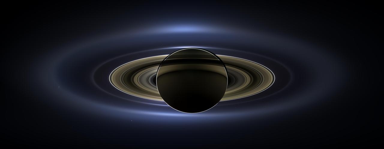
On July 19, 2013, in an event celebrated the world over, NASA's Cassini spacecraft slipped into Saturn's shadow and turned to image the planet, seven of its moons, its inner rings -- and, in the background, our home planet, Earth. With the sun's powerful and potentially damaging rays eclipsed by Saturn itself, Cassini's onboard cameras were able to take advantage of this unique viewing geometry. They acquired a panoramic mosaic of the Saturn system that allows scientists to see details in the rings and throughout the system as they are backlit by the sun. This mosaic is special as it marks the third time our home planet was imaged from the outer solar system; the second time it was imaged by Cassini from Saturn's orbit; and the first time ever that inhabitants of Earth were made aware in advance that their photo would be taken from such a great distance. With both Cassini's wide-angle and narrow-angle cameras aimed at Saturn, Cassini was able to capture 323 images in just over four hours. This final mosaic uses 141 of those wide-angle images. Images taken using the red, green and blue spectral filters of the wide-angle camera were combined and mosaicked together to create this natural-color view. A brightened version with contrast and color enhanced (Figure 1), a version with just the planets annotated (Figure 2), and an annotated version (Figure 3) are shown above. This image spans about 404,880 miles (651,591 kilometers) across. The outermost ring shown here is Saturn's E ring, the core of which is situated about 149,000 miles (240,000 kilometers) from Saturn. The geysers erupting from the south polar terrain of the moon Enceladus supply the fine icy particles that comprise the E ring; diffraction by sunlight gives the ring its blue color. Enceladus (313 miles, or 504 kilometers, across) and the extended plume formed by its jets are visible, embedded in the E ring on the left side of the mosaic. At the 12 o'clock position and a bit inward from the E ring lies the barely discernible ring created by the tiny, Cassini-discovered moon, Pallene (3 miles, or 4 kilometers, across). (For more on structures like Pallene's ring, see PIA08328). The next narrow and easily seen ring inward is the G ring. Interior to the G ring, near the 11 o'clock position, one can barely see the more diffuse ring created by the co-orbital moons, Janus (111 miles, or 179 kilometers, across) and Epimetheus (70 miles, or 113 kilometers, across). Farther inward, we see the very bright F ring closely encircling the main rings of Saturn. Following the outermost E ring counter-clockwise from Enceladus, the moon Tethys (662 miles, or 1,066 kilometers, across) appears as a large yellow orb just outside of the E ring. Tethys is positioned on the illuminated side of Saturn; its icy surface is shining brightly from yellow sunlight reflected by Saturn. Continuing to about the 2 o'clock position is a dark pixel just outside of the G ring; this dark pixel is Saturn's Death Star moon, Mimas (246 miles, or 396 kilometers, across). Mimas appears, upon close inspection, as a very thin crescent because Cassini is looking mostly at its non-illuminated face. The moons Prometheus, Pandora, Janus and Epimetheus are also visible in the mosaic near Saturn's bright narrow F ring. Prometheus (53 miles, or 86 kilometers, across) is visible as a faint black dot just inside the F ring and at the 9 o'clock position. On the opposite side of the rings, just outside the F ring, Pandora (50 miles, or 81 kilometers, across) can be seen as a bright white dot. Pandora and Prometheus are shepherd moons and gravitational interactions between the ring and the moons keep the F ring narrowly confined. At the 11 o'clock position in between the F ring and the G ring, Janus (111 miles, or 179 kilometers, across) appears as a faint black dot. Janus and Prometheus are dark for the same reason Mimas is mostly dark: we are looking at their non-illuminated sides in this mosaic. Midway between the F ring and the G ring, at about the 8 o'clock position, is a single bright pixel, Epimetheus. Looking more closely at Enceladus, Mimas and Tethys, especially in the brightened version of the mosaic, one can see these moons casting shadows through the E ring like a telephone pole might cast a shadow through a fog. In the non-brightened version of the mosaic, one can see bright clumps of ring material orbiting within the Encke gap near the outer edge of the main rings and immediately to the lower left of the globe of Saturn. Also, in the dark B ring within the main rings, at the 9 o'clock position, one can see the faint outlines of two spoke features, first sighted by NASA's Voyager spacecraft in the early 1980s and extensively studied by Cassini. Finally, in the lower right of the mosaic, in between the bright blue E ring and the faint but defined G ring, is the pale blue dot of our planet, Earth. Look closely and you can see the moon protruding from the Earth's lower right. (For a higher resolution view of the Earth and moon taken during this campaign, see PIA14949.) Earth's twin, Venus, appears as a bright white dot in the upper left quadrant of the mosaic, also between the G and E rings. Mars also appears as a faint red dot embedded in the outer edge of the E ring, above and to the left of Venus. For ease of visibility, Earth, Venus, Mars, Enceladus, Epimetheus and Pandora were all brightened by a factor of eight and a half relative to Saturn. Tethys was brightened by a factor of four. In total, 809 background stars are visible and were brightened by a factor ranging from six, for the brightest stars, to 16, for the faintest. The faint outer rings (from the G ring to the E ring) were also brightened relative to the already bright main rings by factors ranging from two to eight, with the lower-phase-angle (and therefore fainter) regions of these rings brightened the most. The brightened version of the mosaic was further brightened and contrast-enhanced all over to accommodate print applications and a wide range of computer-screen viewing conditions. Some ring features -- such as full rings traced out by tiny moons -- do not appear in this version of the mosaic because they require extreme computer enhancement, which would adversely affect the rest of the mosaic. This version was processed for balance and beauty. This view looks toward the unlit side of the rings from about 17 degrees below the ring plane. Cassini was approximately 746,000 miles (1.2 million kilometers) from Saturn when the images in this mosaic were taken. Image scale on Saturn is about 45 miles (72 kilometers) per pixel. This mosaic was made from pictures taken over a span of more than four hours while the planets, moons and stars were all moving relative to Cassini. Thus, due to spacecraft motion, these objects in the locations shown here were not in these specific places over the entire duration of the imaging campaign. Note also that Venus appears far from Earth, as does Mars, because they were on the opposite side of the sun from Earth. http://photojournal.jpl.nasa.gov/catalog/PIA17172